

Impact of Elevation and Hydrography Data on Modeled Flood Map Accuracy Using ARC and Curve2Flood
 , , , , ,
  and
and 
Abstract
1. Introduction
1.1. Large Scale Flood Mapping Efforts
1.2. Global Elevation Data Sources
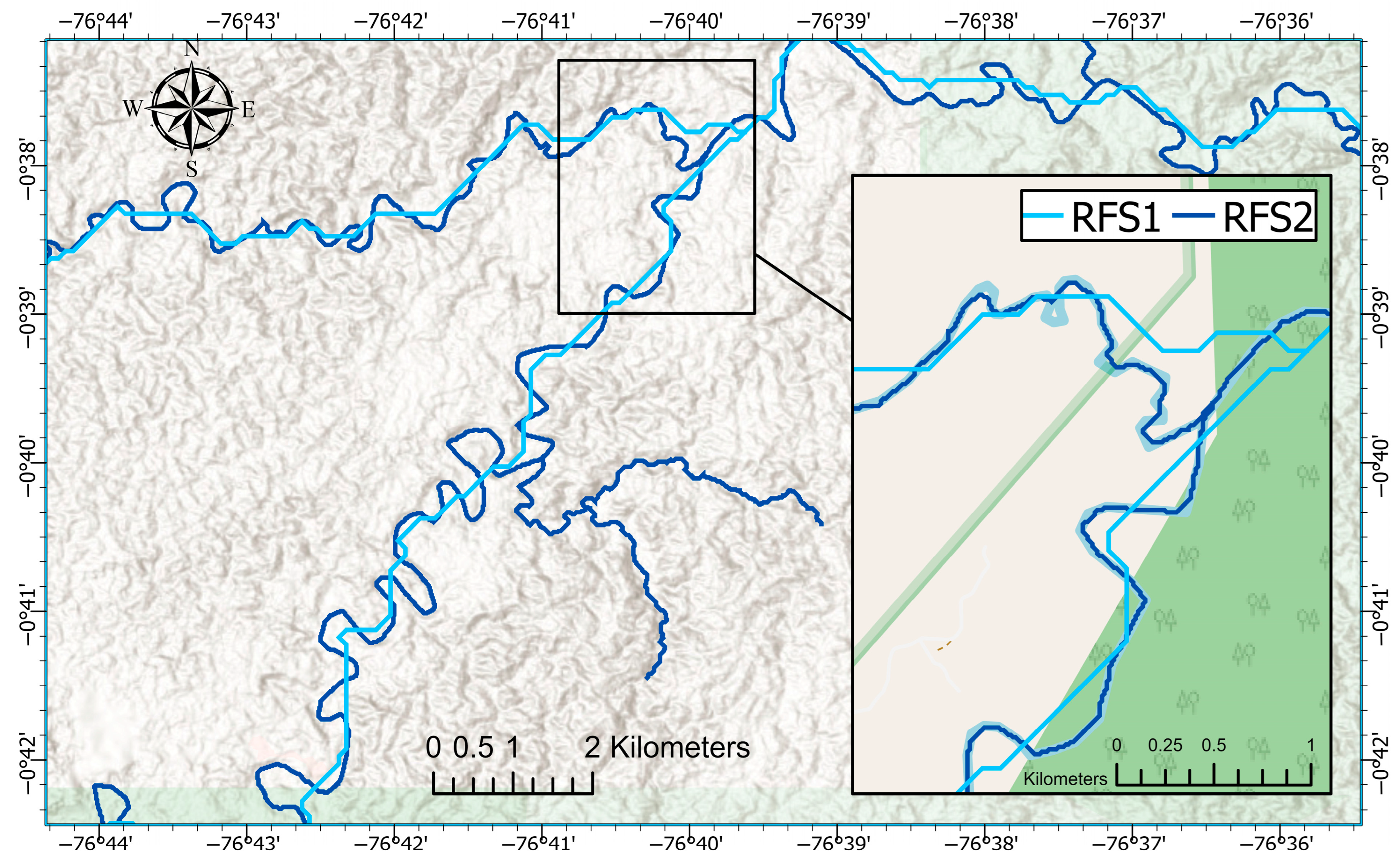
1.3. Global Hydrography Data Sources
1.4. Research Objective
2. Methods
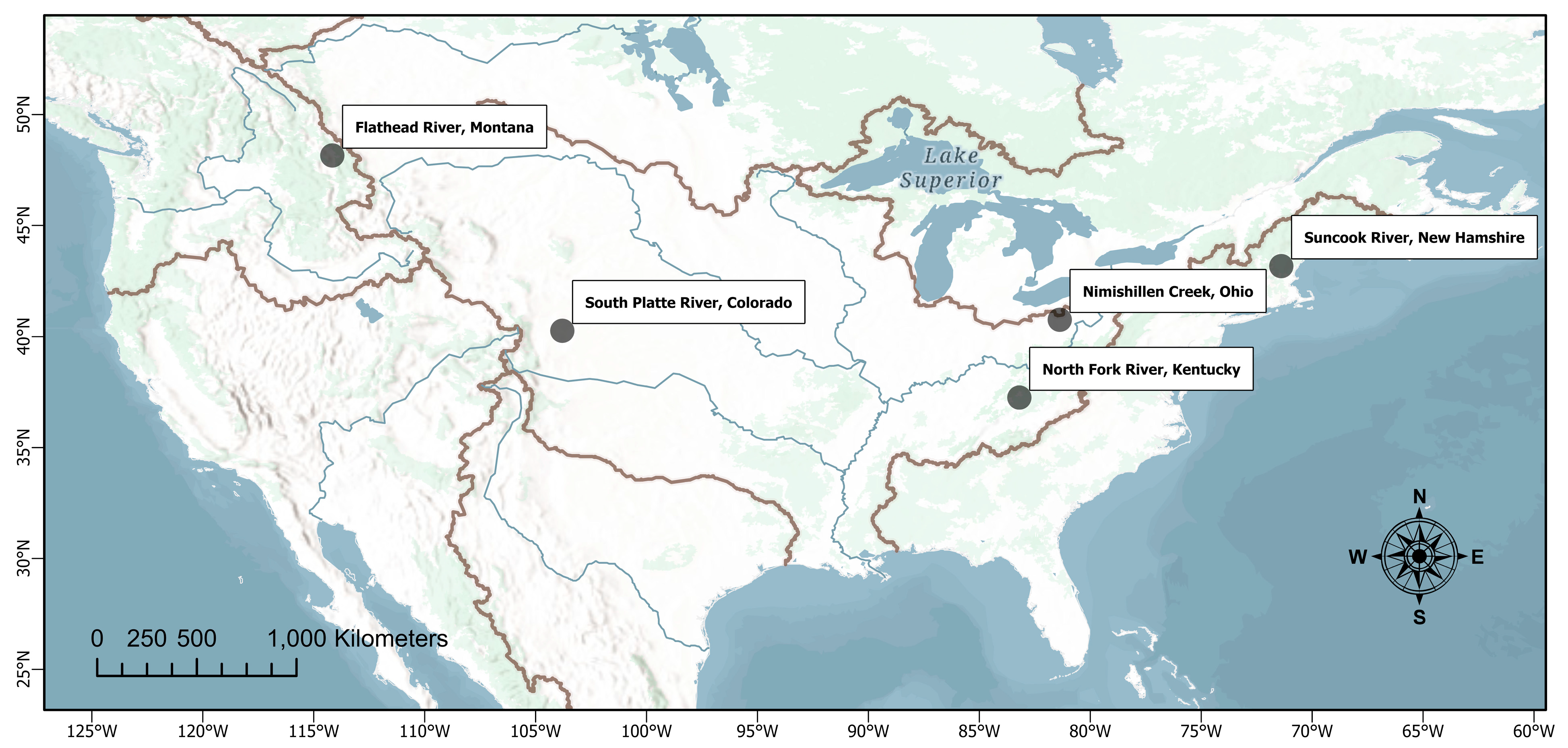
2.1. Study Areas and Flood Scenarios
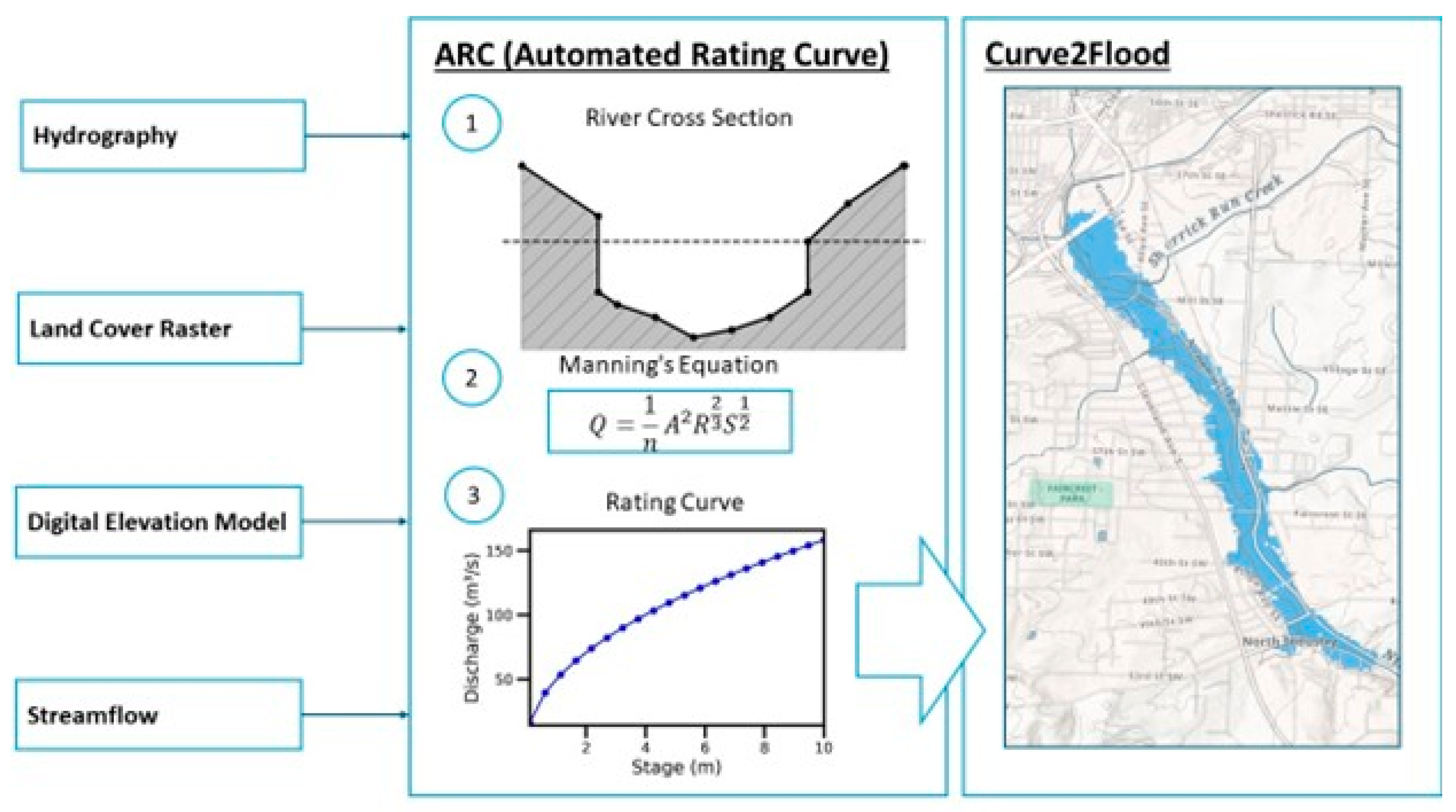
2.2. ARC and Curve2Flood Method Overview
2.3. Flood Map Production
3. Results
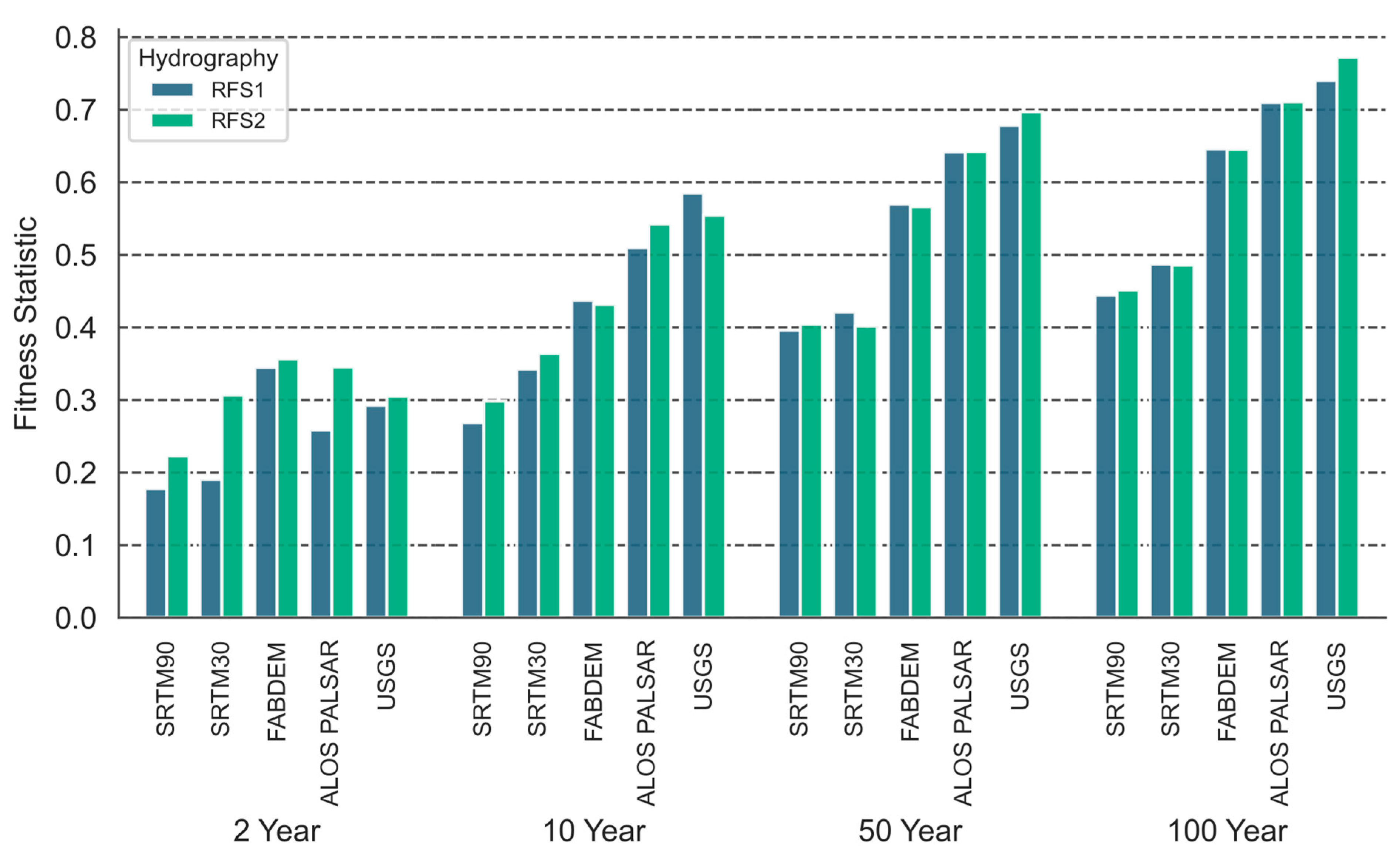
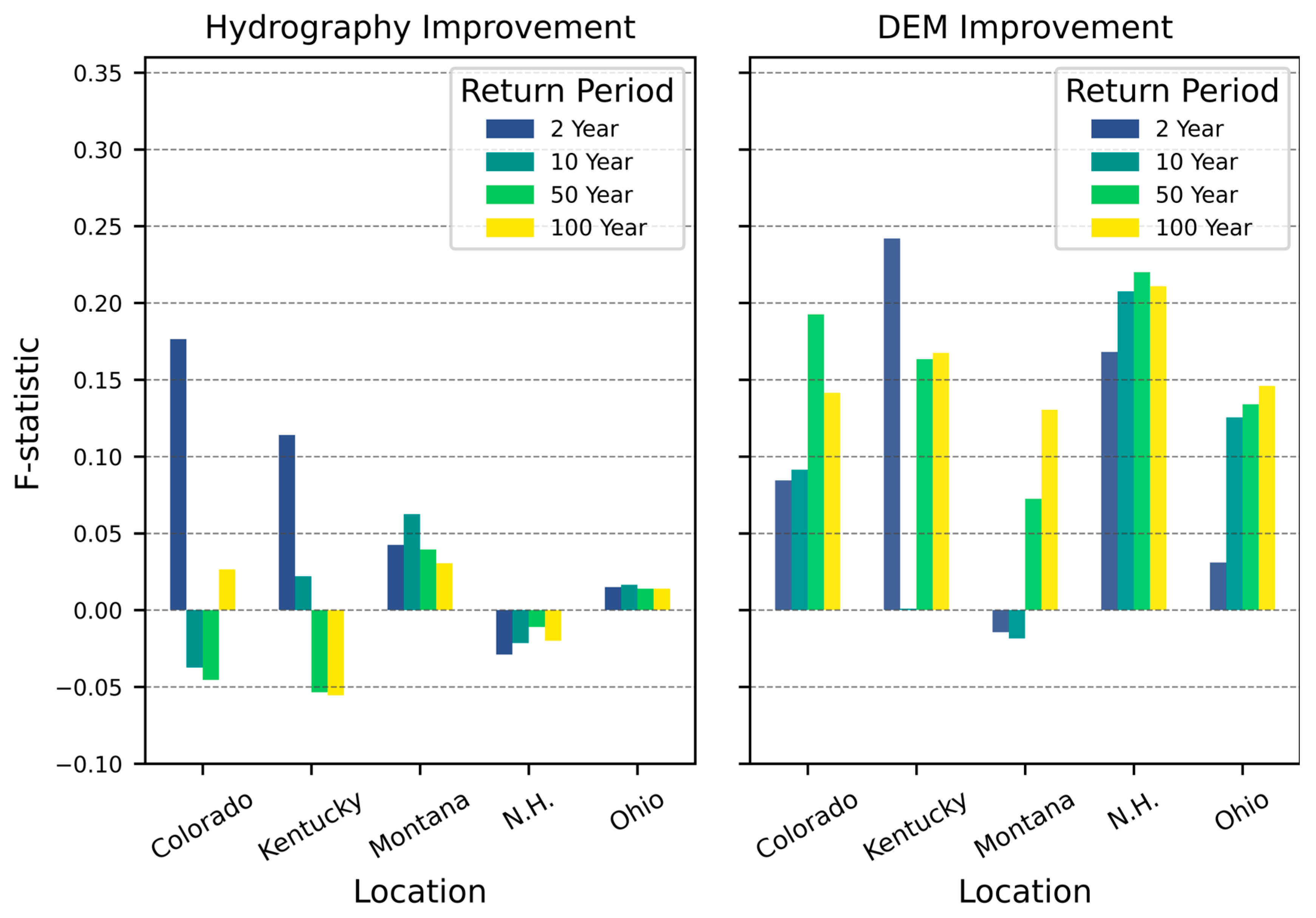
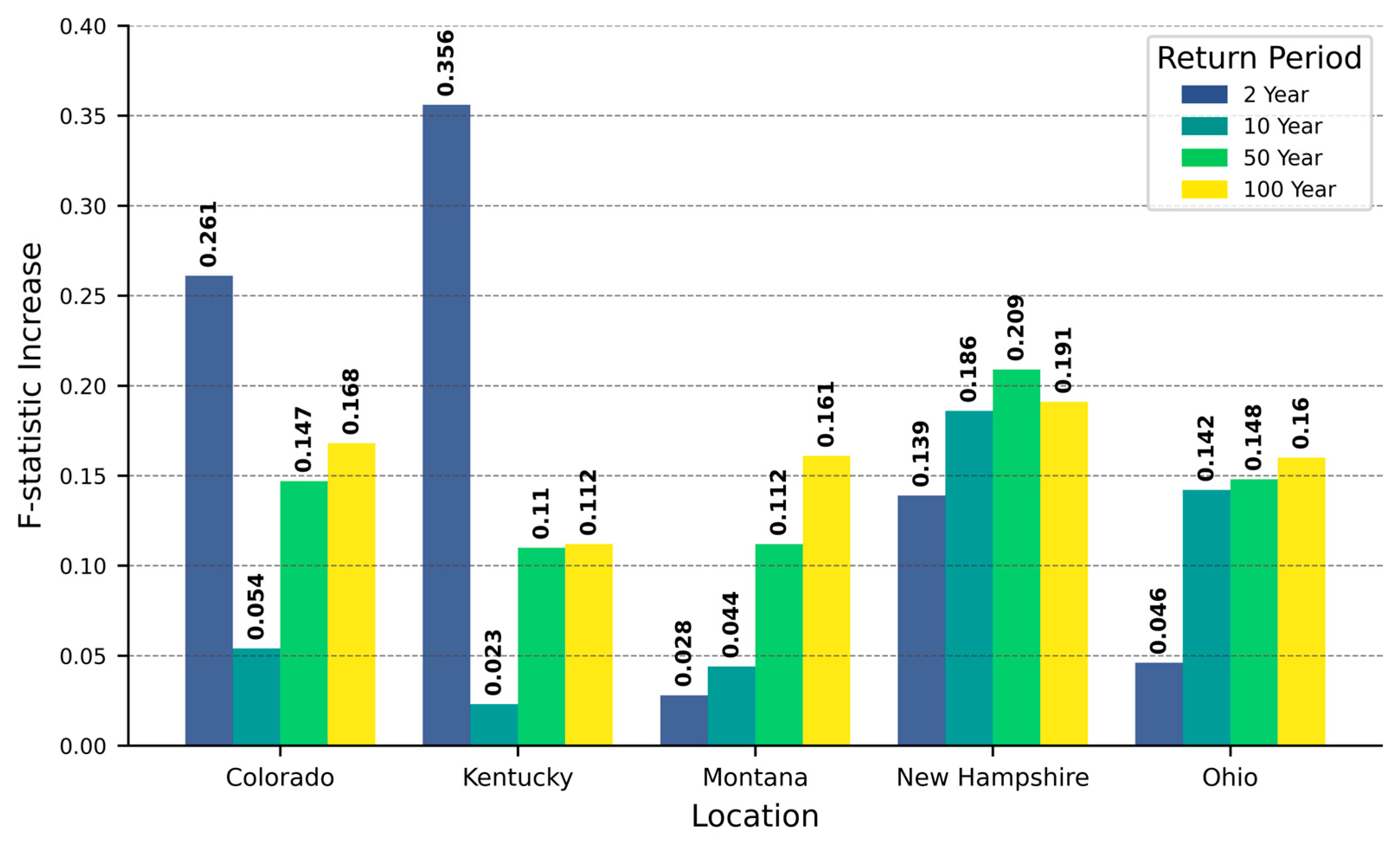
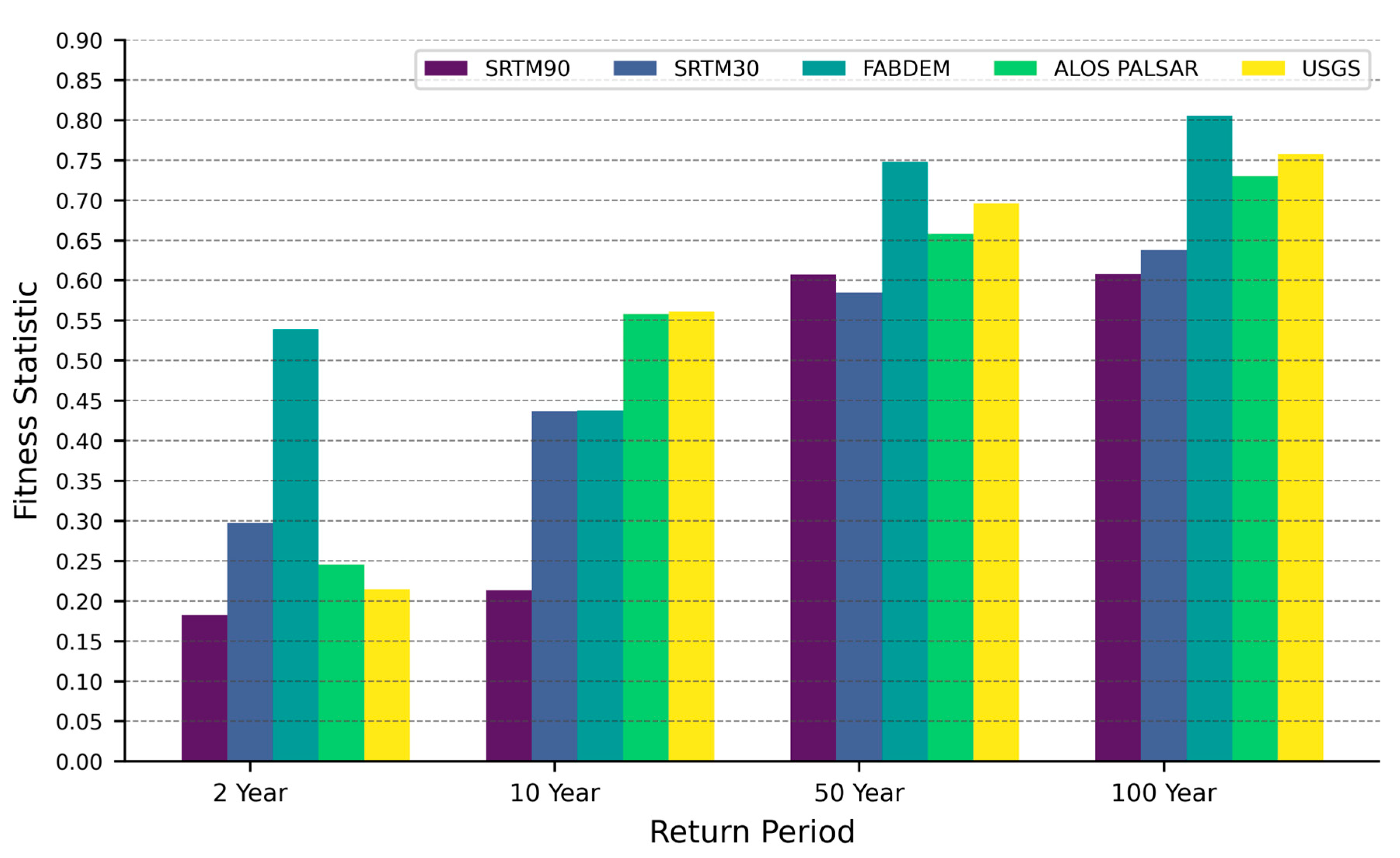
3.1. General Trends from All Simulations
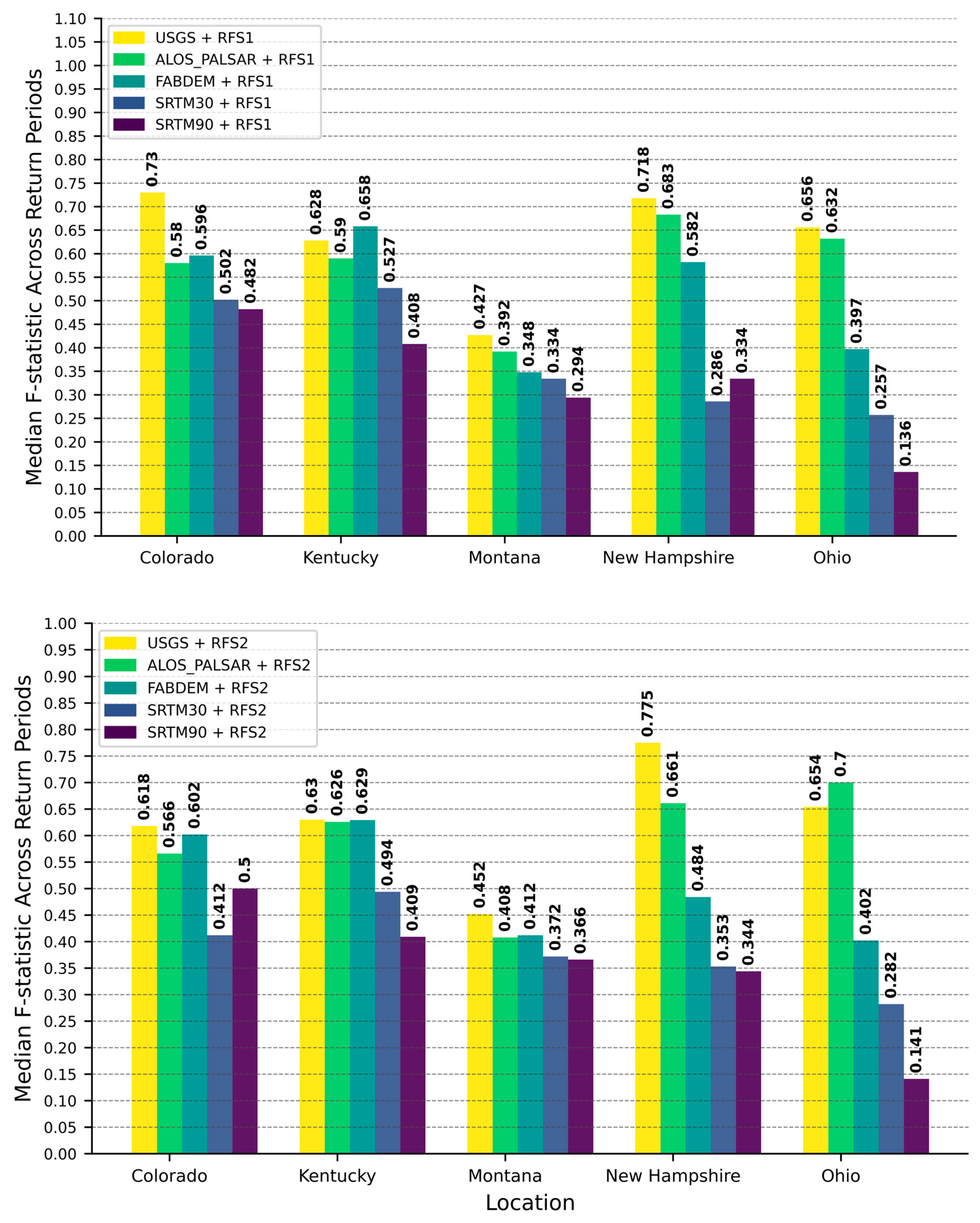
3.2. Extending the Evaluation to Additional DEM Elevations for Flood Mapping
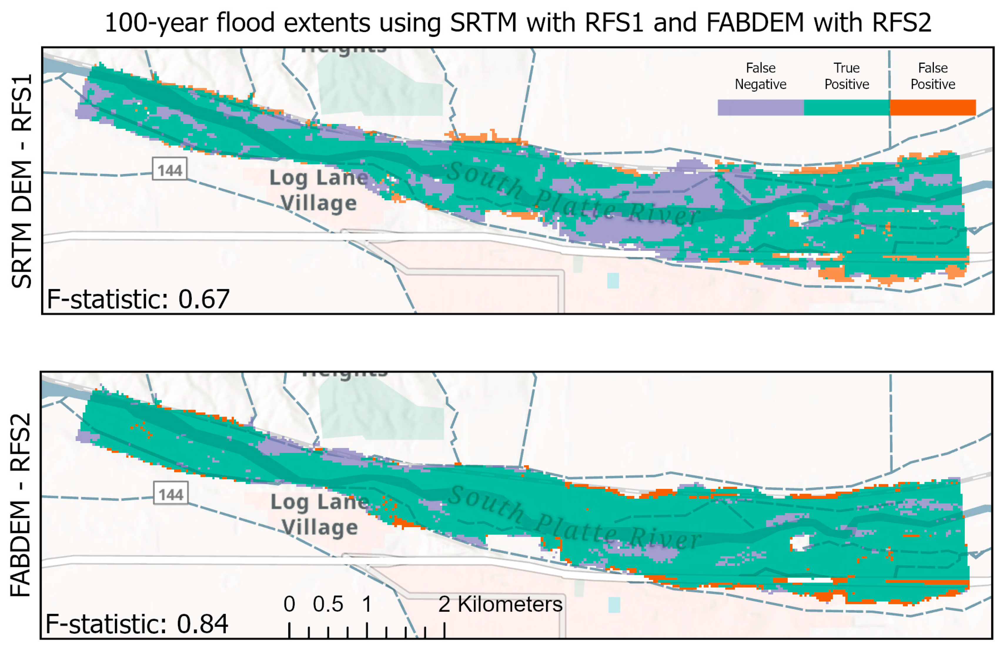
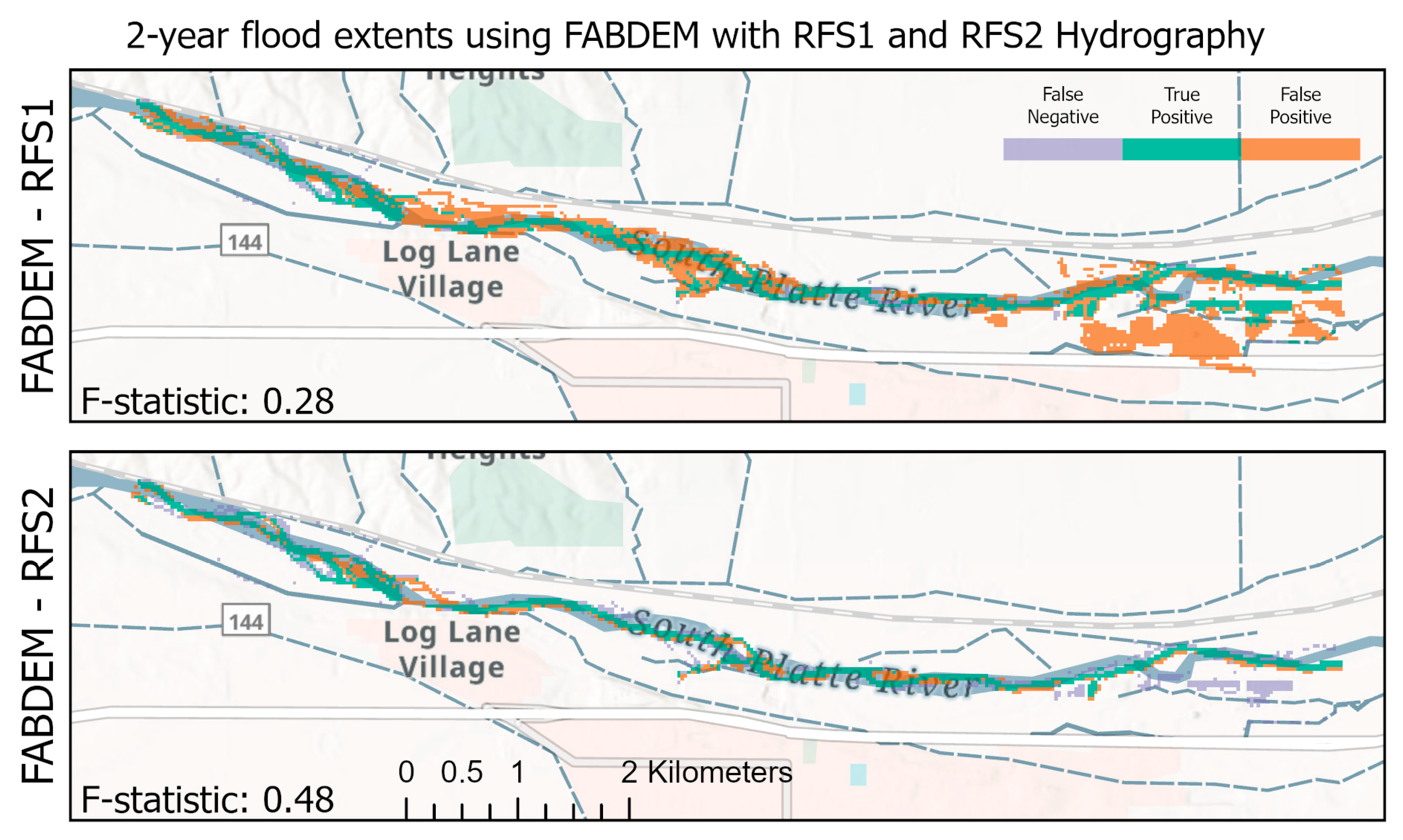
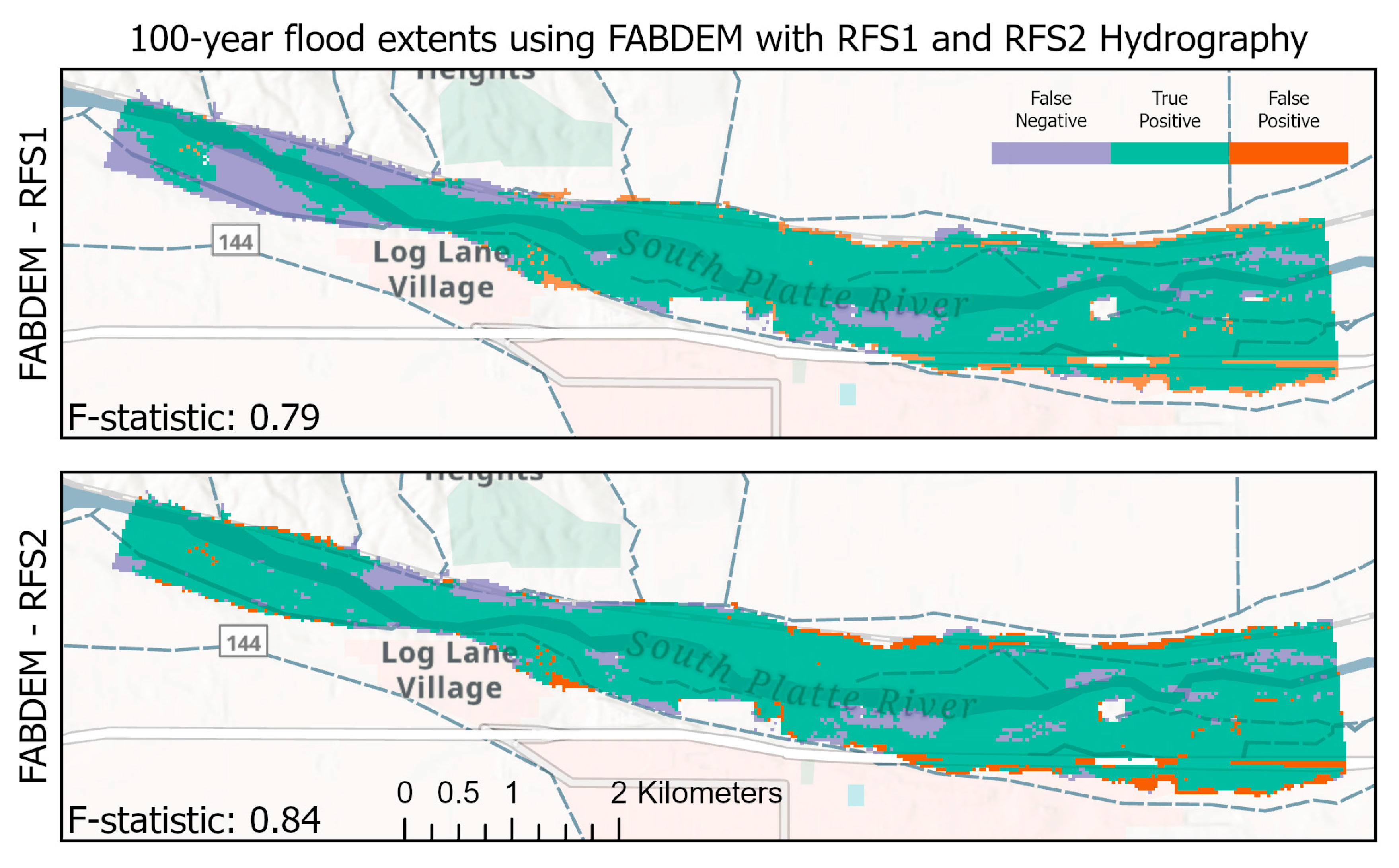
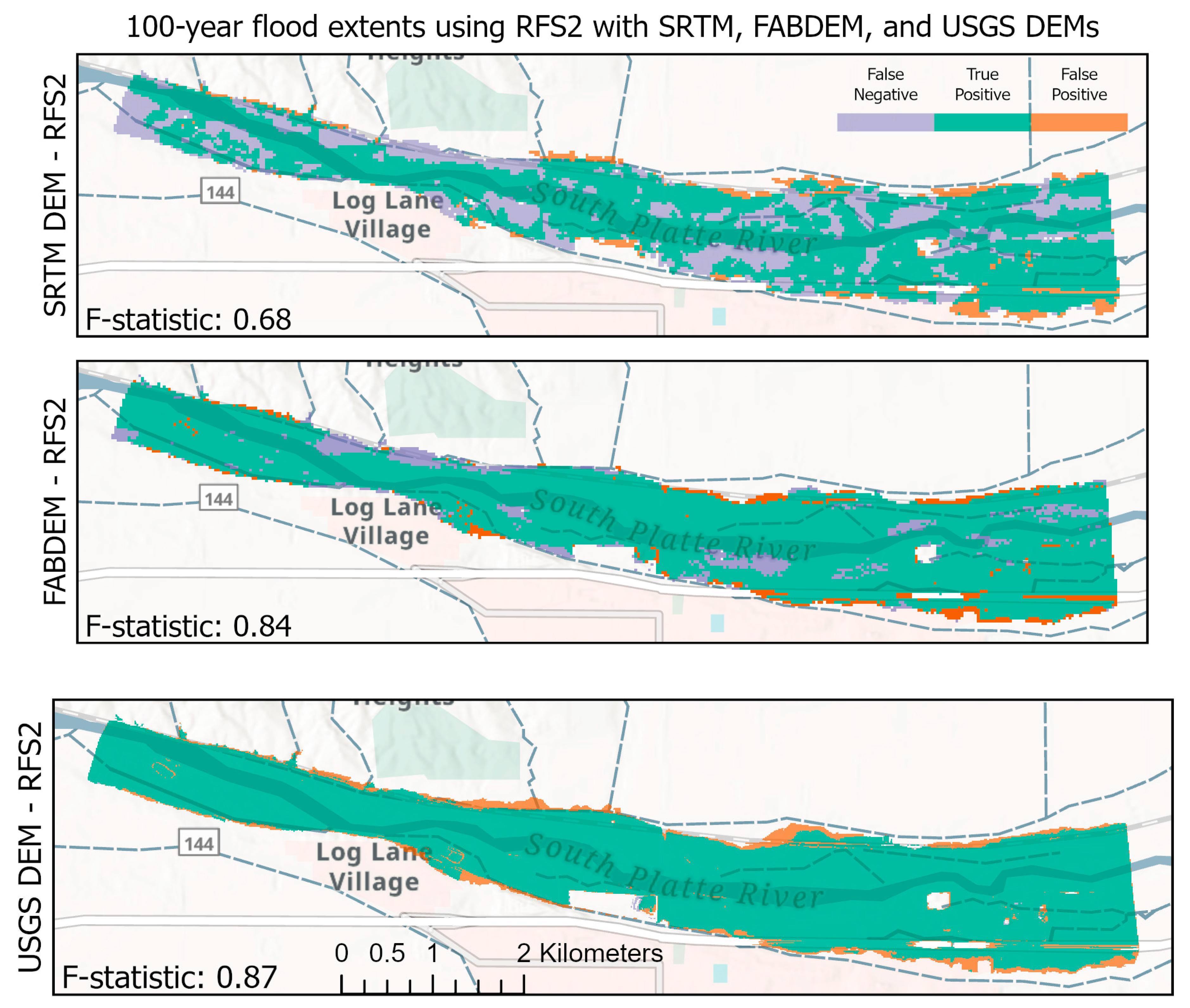
3.3. Evaluation of Selected Flood Extent Maps
4. Conclusions
Author Contributions
Funding
Data Availability Statement
Acknowledgments
Conflicts of Interest
References
- Flood Inundation Mapper. Available online: https://fim.wim.usgs.gov/fim/ (accessed on 11 April 2025).
- Salamon, P.; Mctlormick, N.; Reimer, C.; Clarke, T.; Bauer-Marschallinger, B.; Wagner, W.; Martinis, S.; Chow, C.; Bohnke, C.; Matgen, P.; et al. The New, Systematic Global Flood Monitoring Product of the Copernicus Emergency Management Service. In Proceedings of the 2021 IEEE International Geoscience and Remote Sensing Symposium IGARSS, Brussels, Belgium, 11 July 2021; IEEE: New York City, NY, USA, 2021; pp. 1053–1056. [Google Scholar]
- Dottori, F.; Salamon, P.; Bianchi, A.; Alfieri, L.; Hirpa, F.A.; Feyen, L. Development and Evaluation of a Framework for Global Flood Hazard Mapping. Adv. Water Resour. 2016, 94, 87–102. [Google Scholar] [CrossRef]
- Nobre, A.D.; Cuartas, L.A.; Momo, M.R.; Severo, D.L.; Pinheiro, A.; Nobre, C.A. HAND Contour: A New Proxy Predictor of Inundation Extent. Hydrol. Process. 2016, 30, 320–333. [Google Scholar] [CrossRef]
- Afshari, S.; Tavakoly, A.A.; Rajib, M.A.; Zheng, X.; Follum, M.L.; Omranian, E.; Fekete, B.M. Comparison of New Generation Low-Complexity Flood Inundation Mapping Tools with a Hydrodynamic Model. J. Hydrol. 2018, 556, 539–556. [Google Scholar] [CrossRef]
- Follum, M.L. AutoRoute Rapid Flood Inundation Model; ERDC/CHL CHETN; US Army Engineer Research and Development Center, Coastal and Hydraulics Laboratory: Vicksburg, MS, USA, 2013. [Google Scholar]
- Follum, M.L.; Tavakoly, A.A.; Niemann, J.D.; Snow, A.D. AutoRAPID: A Model for Prompt Streamflow Estimation and Flood Inundation Mapping over Regional to Continental Extents. J. Am. Water Resour. Assoc. 2017, 53, 280–299. [Google Scholar] [CrossRef]
- Follum, M.L. Automated-Rating-Curve. Available online: https://github.com/MikeFHS/automated-rating-curve/wiki/Home (accessed on 23 May 2025).
- Dobbs, K. Flood Inundation Surface Topology (FIST) Modeling and Applications. Available online: https://bluewaters.ncsa.illinois.edu/science-teams@page=detail&psn=bazt (accessed on 14 April 2025).
- Wing, O.E.J.; Quinn, N.; Bates, P.D.; Neal, J.C.; Smith, A.M.; Sampson, C.C.; Coxon, G.; Yamazaki, D.; Sutanudjaja, E.H.; Alfieri, L. Toward Global Stochastic River Flood Modeling. Water Resour. Res. 2020, 56, e2020WR027692. [Google Scholar] [CrossRef]
- Ward, E. Global Sensitivity Analysis of Terrain Effects in Geolocation Systems. IEEE Trans. Aerosp. Electron. Syst. 2015, 51, 2039–2046. [Google Scholar] [CrossRef]
- Olsen, N.R.; Tavakoly, A.A.; McCormack, K.A.; Levin, H.K. Effect of User Decision and Environmental Factors on Computationally Derived River Networks. J. Geophys. Res. Earth Surf. 2023, 128, e2022JF006873. [Google Scholar] [CrossRef]
- Tarboton, D.G.; Bras, R.L.; Rodriguez-Iturbe, I. On the Extraction of Channel Networks from Digital Elevation Data. Hydrol. Process. 1991, 5, 81–100. [Google Scholar] [CrossRef]
- Schumann, G.J.-P.; Bates, P.D.; Neal, J.C.; Andreadis, K.M. Chapter 2—Measuring and Mapping Flood Processes. In Hydro-Meteorological Hazards, Risks and Disasters; Shroder, J.F., Paron, P., Baldassarre, G.D., Eds.; Elsevier: Boston, MA, USA, 2015; pp. 35–64. ISBN 978-0-12-394846-5. [Google Scholar]
- Yamazaki, D.; Ikeshima, D.; Tawatari, R.; Yamaguchi, T.; O’Loughlin, F.; Neal, J.C.; Sampson, C.C.; Kanae, S.; Bates, P.D. A High-accuracy Map of Global Terrain Elevations. Geophys. Res. Lett. 2017, 44, 5844–5853. [Google Scholar] [CrossRef]
- Aristizabal, F.; Chegini, T.; Petrochenkov, G.; Salas, F.; Judge, J. Effects of High-Quality Elevation Data and Explanatory Variables on the Accuracy of Flood Inundation Mapping via Height Above Nearest Drainage. Hydrol. Earth Syst. Sci. 2024, 28, 1287–1315. [Google Scholar] [CrossRef]
- Xu, K.; Fang, J.; Fang, Y.; Sun, Q.; Wu, C.; Liu, M. The Importance of Digital Elevation Model Selection in Flood Simulation and a Proposed Method to Reduce DEM Errors: A Case Study in Shanghai. Int. J. Disaster Risk Sci. 2021, 12, 890–902. [Google Scholar] [CrossRef]
- Sampson, C.C.; Smith, A.M.; Bates, P.D.; Neal, J.C.; Trigg, M.A. Perspectives on Open Access High Resolution Digital Elevation Models to Produce Global Flood Hazard Layers. Front. Earth Sci. 2016, 3, 85. [Google Scholar] [CrossRef]
- Johnson, J.M.; Munasinghe, D.; Eyelade, D.; Cohen, S. An Integrated Evaluation of the National Water Model (NWM)–Height Above Nearest Drainage (HAND) Flood Mapping Methodology. Nat. Hazards Earth Syst. Sci. 2019, 19, 2405–2420. [Google Scholar] [CrossRef]
- Farr, T.G.; Rosen, P.A.; Caro, E.; Crippen, R.; Duren, R.; Hensley, S.; Kobrick, M.; Paller, M.; Rodriguez, E.; Roth, L.; et al. The Shuttle Radar Topography Mission. Rev. Geophys. 2007, 45, RG2004. [Google Scholar] [CrossRef]
- Lehner, B.; Verdin, K.; Jarvis, A. New Global Hydrography Derived from Spaceborne Elevation Data. Eos Trans. Am. Geophys. Union 2008, 89, 93–94. [Google Scholar] [CrossRef]
- Lehner, B.; Grill, G. Global River Hydrography and Network Routing: Baseline Data and New Approaches to Study the World’s Large River Systems. Hydrol. Process. 2013, 27, 2171–2186. [Google Scholar] [CrossRef]
- Frasson, R.P.D.M.; Pavelsky, T.M.; Fonstad, M.A.; Durand, M.T.; Allen, G.H.; Schumann, G.; Lion, C.; Beighley, R.E.; Yang, X. Global Relationships Between River Width, Slope, Catchment Area, Meander Wavelength, Sinuosity, and Discharge. Geophys. Res. Lett. 2019, 46, 3252–3262. [Google Scholar] [CrossRef]
- Yan, D.; Wang, K.; Qin, T.; Weng, B.; Wang, H.; Bi, W.; Li, X.; Li, M.; Lv, Z.; Liu, F.; et al. A Data Set of Global River Networks and Corresponding Water Resources Zones Divisions. Sci. Data 2019, 6, 219. [Google Scholar] [CrossRef]
- Carlson, K.A.; Levin, H.K.; Morris, A.L.; Candela, S.G.; Rivera, A.M.M.; Huening, V.G.; Fredericks, J.G. TDX-Hydro: Global High-Resolution Hydrography Derived from TanDEM-X. ESS Open Arch. 2024. [Google Scholar] [CrossRef]
- Hawker, L.; Uhe, P.; Paulo, L.; Sosa, J.; Savage, J.; Sampson, C.; Neal, J. A 30 m Global Map of Elevation with Forests and Buildings Removed. Environ. Res. Lett. 2022, 17, 024016. [Google Scholar] [CrossRef]
- Krieger, G.; Moreira, A.; Fiedler, H.; Hajnsek, I.; Werner, M.; Younis, M.; Zink, M. TanDEM-X: A Satellite Formation for High-Resolution SAR Interferometry. IEEE Trans. Geosci. Remote Sens. 2007, 45, 3317–3341. [Google Scholar] [CrossRef]
- Rosenqvist, A.; Shimada, M.; Ito, N.; Watanabe, M. ALOS PALSAR: A Pathfinder Mission for Global-Scale Monitoring of the Environment. IEEE Trans. Geosci. Remote Sens. 2007, 45, 3307–3316. [Google Scholar] [CrossRef]
- 1/3rd Arc-Second Digital Elevation Models (DEMs)-USGS National Map 3DEP Downloadable Data Collection-ScienceBase-Catalog. Available online: https://www.sciencebase.gov/catalog/item/4f70aa9fe4b058caae3f8de5 (accessed on 9 May 2025).
- Riegler, G.; Hennig, S.D.; Weber, M. WORLDDEM—A Novel Global Foundation Layer. Int. Arch. Photogramm. Remote Sens. Spatial Inf. Sci. 2015, XL-3/W2, 183–187. [Google Scholar] [CrossRef]
- European Space Agency. Airbus Copernicus DEM. Available online: https://doi.org/10.5270/ESA-c5d3d65 (accessed on 30 July 2025).
- Huang, J.; Yang, Y. Vertical Accuracy Assessment of the ASTER, SRTM, GLO-30, and ATLAS in a Forested Environment. Forests 2024, 15, 426. [Google Scholar] [CrossRef]
- Nandam, V.; Patel, P.L. A Framework to Assess Suitability of Global Digital Elevation Models for Hydrodynamic Modelling in Data Scarce Regions. J. Hydrol. 2024, 630, 130654. [Google Scholar] [CrossRef]
- Zandsalimi, Z.; Feizabadi, S.; Yazdi, J.; Salehi Neyshabouri, S.A.A. Evaluating the Impact of Digital Elevation Models on Urban Flood Modeling: A Comprehensive Analysis of Flood Inundation, Hazard Mapping, and Damage Estimation. Water Resour. Manag. 2024, 38, 4243–4268. [Google Scholar] [CrossRef]
- Pandya, D.; Rana, V.K.; Suryanarayana, T.M.V. Inter-Comparison and Assessment of Digital Elevation Models for Hydrological Applications in the Upper Mahi River Basin. Appl. Geomat. 2024, 16, 191–214. [Google Scholar] [CrossRef]
- Ferreira, Z.; Cabral, P. Vertical Accuracy Assessment of ALOS PALSAR, GMTED2010, SRTM and Topodata Digital Elevation Models. In Proceedings of the 7th International Conference on Geographical Information Systems Theory, Applications and Management—GISTAM, Online, 23–25 April 2021; SciTePress: Setubal, Portugal, 2021; pp. 116–124. [Google Scholar]
- Shimada, M.; Itoh, T.; Motooka, T.; Watanabe, M.; Shiraishi, T.; Thapa, R.; Lucas, R. New Global Forest/Non-Forest Maps from ALOS PALSAR Data (2007–2010). Remote Sens. Environ. 2014, 155, 13–31. [Google Scholar] [CrossRef]
- Ashby, K.R.; Hales, R.C.; Nelson, J.; Ames, D.P.; Williams, G.P. Hydroviewer: A Web Application to Localize Global Hydrologic Forecasts. Open Water J. 2021, 7, 9. [Google Scholar]
- Hales, R.C.; Nelson, E.J.; Souffront, M.; Gutierrez, A.L.; Prudhomme, C.; Kopp, S.; Ames, D.P.; Williams, G.P.; Jones, N.L. Advancing Global Hydrologic Modeling with the GEOGloWS ECMWF Streamflow Service. J. Flood Risk Manag. 2025, 18, e12859. [Google Scholar] [CrossRef]
- Hales, R.C.; Nelson, E.J.; Kopp, S.; Levin, H.K.; Morris, A.L.; Souffront Alcantara, M.A.; Gutiérrez, A.; Magoffin, R.H.; Rosas, L.; Baaniya, Y. The Second Generation Geoglows River Forecast System. SSRN 2025. [Google Scholar] [CrossRef]
- Gutenson, J.L. How Has Curve2Flood Performed Compared to USGS Flood Inundation Maps? Available online: https://github.com/MikeFHS/curve2flood/wiki/How-has-Curve2Flood-performed-compared-to-USGS-flood-inundation-maps%3F (accessed on 28 March 2025).
- MikeFHS MikeFHS/Automated-Rating-Curve. Available online: https://github.com/MikeFHS/automated-rating-curve (accessed on 11 April 2025).
- Boldt, J.A.; Lant, J.G.; Kolarik, N.E. Flood-Inundation Maps for the North Fork Kentucky River at Hazard, Kentucky; U.S. Geological Survey: Reston, VA, USA, 2018. [Google Scholar]
- Flynn, R.H.; Johnston, C.M.; Hayes, L. Flood-Inundation Maps for the Suncook River in Epsom, Pembroke, Allenstown, and Chichester, New Hampshire; U.S. Geological Survey: Reston, VA, USA, 2012. [Google Scholar]
- Kohn, M.S.; Patton, T.T. Flood-Inundation Maps for the South Platte River at Fort Morgan, Colorado, 2018; U.S. Geological Survey: Reston, VA, USA, 2018. [Google Scholar]
- Price, A. Flood-Inundation Maps for the Flathead River from Columbia Falls, Montana to the Holt Stage Road Bridge Near Kalispell, Montana, 2017; U.S. Geological Survey: Reston, VA, USA, 2017. [Google Scholar]
- Whitehead, M. Flood-Inundation Maps for Nimishillen Creek Near North Industry, Ohio, 2019. Available online: https://pubs.usgs.gov/publication/sir20195083 (accessed on 12 April 2025).
- Chow, V.T.; Maidment, D.R.; Mays, L.W. Applied Hydrology; McGraw-Hill Series in Water Resources and Environmental Engineering; McGraw-Hill: New York, NY, USA, 1988; ISBN 0-07-010810-2. [Google Scholar]
- England, J.F.; Cohn, T.A.; Faber, B.A.; Stedinger, J.R.; Thomas, W.O.; Veilleux, A.G.; Kiang, J.E.; Mason, R.R. Guidelines for Determining Flood Flow Frequency-Bulletin 17C. In U.S. Geological Survey Techniques and Methods, Book 4; U.S. Geological Survey: Reston, VA, USA, 2018. [Google Scholar]
- Follum, M.L.; Vera, R.; Tavakoly, A.A.; Gutenson, J.L. Improved Accuracy and Efficiency of Flood Inundation Mapping of Low-, Medium-, and High-Flow Events Using the AutoRoute Model. Nat. Hazards Earth Syst. Sci. 2020, 20, 625–641. [Google Scholar] [CrossRef]
- Bates, P.D.; De Roo, A.P.J. A Simple Raster-Based Model for Flood Inundation Simulation. J. Hydrol. 2000, 236, 54–77. [Google Scholar] [CrossRef]
- Praskievicz, S.; Carter, S.; Dhondia, J.; Follum, M. Flood-Inundation Modeling in an Operational Context: Sensitivity to Topographic Resolution and Manning’s n. J. Hydroinform. 2020, 22, 1338–1350. [Google Scholar] [CrossRef]
- Provost, F.; Kohavi, R. Guest Editors’ Introduction: On Applied Research in Machine Learning. Mach. Learn. 1998, 30, 127–132. [Google Scholar] [CrossRef]
- Wilks, D.S. Statistical Methods in the Atmospheric Sciences; Elsevier: Amsterdam, The Netherlands, 2019; ISBN 978-0-12-815823-4. [Google Scholar]
- Li, Z.; Duque, F.Q.; Grout, T.; Bates, B.; Demir, I. Comparative Analysis of Performance and Mechanisms of Flood Inundation Map Generation Using Height Above Nearest Drainage. Environ. Model. Softw. 2023, 159, 105565. [Google Scholar] [CrossRef]
- Juurlink, D.N.; Detsky, A.S. Kappa Statistic. CMAJ 2005, 173, 16. [Google Scholar] [CrossRef]

| DEM | Spatial Resolution | Vertical Accuracy | Spatial Coverage | Acquisition Date | Providing Agency | Availability | Citation |
|---|---|---|---|---|---|---|---|
| SRTM | 30 m, 90 m | ±16 m | 60° N-56° S | February-2000 | NASA | Free, Public | [20] |
| TanDEM-X | 12 m | ±2 m | Pole-to-pole | December-2010 to January-2015 | Airbus | Private | [27] |
| FABDEM | 30 m | ±2 m | Pole-to-pole | December-2010 to January-2015 | University of Bristol | Free, Public | [26] |
| ALOS DEM | 12.5 m | ±9 m | 60° N-59° S | January-2006 to April-2011 | Japan Aerospace Exploration Agency | Free, Public | [28] |
| USGS 3DEP DEM | 10 m | ±1 m | Conterminous US | 1923 to Present | U.S. Geological Survey | Free, Public | [29] |
| River Name | Location | Köppen–Geiger Classification | USGS Gauges | Drainage Area (km2) | Water Level Range | Domain Length | Sources |
|---|---|---|---|---|---|---|---|
| North Fork Kentucky River | Kentucky | Temperate (cfa) | 03277500 | 1207 | 4.3–11.9 m | 11.4 km | [43] |
| Suncook River | New Hampshire | Continental (dfb) | 01089500 | 4072 | 2.1–5.5 m | 26.5 km | [44] |
| South Platte River | Colorado | Dry (bsk) | 06759500 | 37,938 | 3.7–8.2 m | 7.2 km | [45] |
| Flathead River | Montana | Dry (dfb) | 12363000, 12366500 | 13,830 | 3.7–7.0 m | 24.1 km | [46] |
| Nimishillen Creek | Ohio | Dry (dfa) | 03118500 | 445 | 2.4–4.3 m | 6.4 km | [47] |
| Return Period | DEM | Hydrography | Proportion Correct | Bias | Hit Rate | Kappa |
|---|---|---|---|---|---|---|
| 2 Year | SRTM90 | RFS1 | 0.9362 | 2.3796 | 0.442 | 0.2674 |
| RFS2 | 0.94 | 2.7026 | 0.5362 | 0.3296 | ||
| SRTM30 | RFS1 | 0.9466 | 1.9422 | 0.4432 | 0.2918 | |
| RFS2 | 0.9618 | 1.4852 | 0.5006 | 0.439 | ||
| FABDEM | RFS1 | 0.9622 | 2.8368 | 0.7462 | 0.4778 | |
| RFS2 | 0.9672 | 2.2546 | 0.6474 | 0.497 | ||
| ALOS PALSAR | RFS1 | 0.9482 | 3.2118 | 0.7286 | 0.3672 | |
| RFS2 | 0.9568 | 2.717 | 0.7606 | 0.48 | ||
| USGS | RFS1 | 0.9624 | 2.3782 | 0.7208 | 0.4186 | |
| RFS2 | 0.9668 | 1.9668 | 0.6886 | 0.4538 | ||
| 10 Year | SRTM90 | RFS1 | 0.9204 | 1.1762 | 0.437 | 0.3696 |
| RFS2 | 0.9268 | 1.2356 | 0.4838 | 0.4094 | ||
| SRTM30 | RFS1 | 0.9368 | 1.1006 | 0.5348 | 0.47 | |
| RFS2 | 0.9424 | 0.9544 | 0.5138 | 0.5 | ||
| FABDEM | RFS1 | 0.9532 | 1.5898 | 0.7666 | 0.5778 | |
| RFS2 | 0.9524 | 1.5966 | 0.766 | 0.5782 | ||
| ALOS PALSAR | RFS1 | 0.9518 | 1.8842 | 0.9334 | 0.6454 | |
| RFS2 | 0.9554 | 1.8004 | 0.9378 | 0.6732 | ||
| USGS | RFS1 | 0.9652 | 1.571 | 0.925 | 0.7158 | |
| RFS2 | 0.9576 | 1.7822 | 0.953 | 0.6842 | ||
| 50 Year | SRTM90 | RFS1 | 0.9146 | 0.9742 | 0.523 | 0.498 |
| RFS2 | 0.9236 | 0.9198 | 0.5156 | 0.5146 | ||
| SRTM30 | RFS1 | 0.9238 | 0.912 | 0.5484 | 0.5354 | |
| RFS2 | 0.9266 | 0.7754 | 0.499 | 0.5292 | ||
| FABDEM | RFS1 | 0.9562 | 1.3234 | 0.8134 | 0.6932 | |
| RFS2 | 0.9576 | 1.2838 | 0.798 | 0.6926 | ||
| ALOS PALSAR | RFS1 | 0.9606 | 1.4122 | 0.918 | 0.756 | |
| RFS2 | 0.9622 | 1.3544 | 0.9042 | 0.7578 | ||
| USGS | RFS1 | 0.9656 | 1.2914 | 0.8988 | 0.7832 | |
| RFS2 | 0.9686 | 1.3092 | 0.9328 | 0.8002 | ||
| 100 Year | SRTM90 | RFS1 | 0.9154 | 0.892 | 0.5554 | 0.5468 |
| RFS2 | 0.9218 | 0.8506 | 0.5464 | 0.5582 | ||
| SRTM30 | RFS1 | 0.9248 | 0.8446 | 0.5886 | 0.5956 | |
| RFS2 | 0.9296 | 0.7616 | 0.5666 | 0.6042 | ||
| FABDEM | RFS1 | 0.9604 | 1.2156 | 0.8456 | 0.7554 | |
| RFS2 | 0.9626 | 1.181 | 0.8346 | 0.7552 | ||
| ALOS PALSAR | RFS1 | 0.9676 | 1.233 | 0.9176 | 0.8096 | |
| RFS2 | 0.9676 | 1.1988 | 0.9054 | 0.8098 | ||
| USGS | RFS1 | 0.9718 | 1.1302 | 0.8954 | 0.8306 | |
| RFS2 | 0.9744 | 1.1856 | 0.9452 | 0.8534 |
Disclaimer/Publisher’s Note: The statements, opinions and data contained in all publications are solely those of the individual author(s) and contributor(s) and not of MDPI and/or the editor(s). MDPI and/or the editor(s) disclaim responsibility for any injury to people or property resulting from any ideas, methods, instructions or products referred to in the content. |
© 2025 by the authors. Licensee MDPI, Basel, Switzerland. This article is an open access article distributed under the terms and conditions of the Creative Commons Attribution (CC BY) license (https://creativecommons.org/licenses/by/4.0/).
Share and Cite
Miskin, T.J.; Rosas, L.R.; Hales, R.C.; Nelson, E.J.; Follum, M.L.; Gutenson, J.L.; Williams, G.P.; Jones, N.L. Impact of Elevation and Hydrography Data on Modeled Flood Map Accuracy Using ARC and Curve2Flood. Hydrology 2025, 12, 202. https://doi.org/10.3390/hydrology12080202
Miskin TJ, Rosas LR, Hales RC, Nelson EJ, Follum ML, Gutenson JL, Williams GP, Jones NL. Impact of Elevation and Hydrography Data on Modeled Flood Map Accuracy Using ARC and Curve2Flood. Hydrology. 2025; 12(8):202. https://doi.org/10.3390/hydrology12080202
Chicago/Turabian StyleMiskin, Taylor James, L. Ricardo Rosas, Riley C. Hales, E. James Nelson, Michael L. Follum, Joseph L. Gutenson, Gustavious P. Williams, and Norman L. Jones. 2025. "Impact of Elevation and Hydrography Data on Modeled Flood Map Accuracy Using ARC and Curve2Flood" Hydrology 12, no. 8: 202. https://doi.org/10.3390/hydrology12080202
APA StyleMiskin, T. J., Rosas, L. R., Hales, R. C., Nelson, E. J., Follum, M. L., Gutenson, J. L., Williams, G. P., & Jones, N. L. (2025). Impact of Elevation and Hydrography Data on Modeled Flood Map Accuracy Using ARC and Curve2Flood. Hydrology, 12(8), 202. https://doi.org/10.3390/hydrology12080202