1. Introduction
The Vietnamese Mekong Delta (VMD), situated in the lower reaches of the Mekong River, is a key region for agricultural production and aquaculture [
1]. Its dense network of rivers and canals plays a crucial role in both water supply and drainage, supporting various farming systems [
2,
3,
4,
5]. However, the region faces significant water-related challenges, including the uneven water distribution for intensive rice cultivation in upstream areas and differences in farming practices across the downstream and coastal zones [
6]. Over time, the planning and management of the hydraulic infrastructure in the VMD have primarily focused on serving agricultural production [
7]. Nonetheless, inconsistencies in irrigation planning across localities have resulted in operational difficulties and inefficiencies [
8]. Biggs et al. (2012) [
5] provided a historical and legacy perspective on the water infrastructure and policy trajectories in the VMD, emphasizing path dependency and the institutional inertia of water governance systems. Moreover, Hoang et al. (2020) [
2] outlined the influence of irrigation infrastructure on the agricultural output in Dong Thap Province, while Minh et al. (2019) [
3] examined the relationship between multi-dike systems and the surface water quality in the VMD. Downes et al. (2025) [
4], who discussed future-oriented resilience planning in rapidly urbanizing zones of the Mekong Delta, with a focus on the institutional and governance aspects outlined that local governance structures often lack coordination between provincial and national agencies, resulting in delayed decision making and the inadequate enforcement of water management policies. Additionally, funding constraints and administrative bottlenecks hinder the timely maintenance and modernization of sluice gate systems. Policy frameworks frequently emphasize short-term water control measures rather than integrated, long-term resilience strategies. As a result, the existing sluice gate operations struggle to effectively regulate water levels in response to extreme hydrological variations, increasing the risk of localized flooding and seasonal water shortages. Despite the various hydraulic interventions, the efficiency of proactive sluice gate operations in the Long Xuyen Quadrangle remains understudied, particularly under extreme hydrological variations. While sluice gate modernization efforts are underway, little empirical evidence exists on how different operational modes affect the water levels in specific localities within the Long Xuyen Quadrangle—particularly under combined climate and infrastructural stress. This gap highlights the need for a scenario-based evaluation of sluice operations to guide more resilient water regulation strategies.
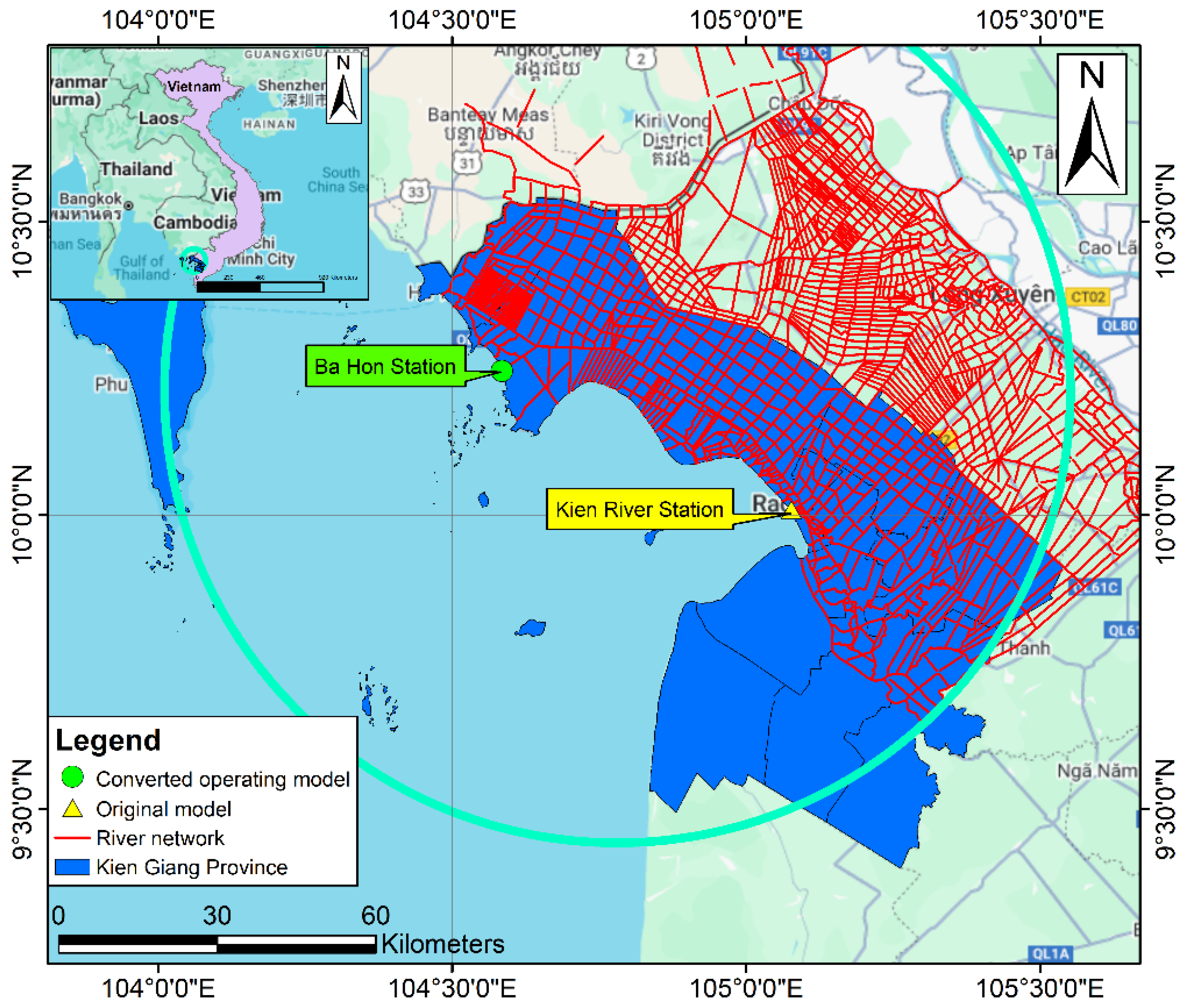
The VMD is highly vulnerable to climate change and rising sea levels, exacerbating the existing hydrological and agricultural challenges. Rising sea levels intensify saltwater intrusion, threatening the freshwater availability and agricultural productivity. This underscores the urgent need for adaptive water management strategies, particularly the enhancement of sluice gate infrastructure. In Kien Giang Province, the flood and salinity control system operates across three key irrigation zones—the Long Xuyen Quadrangle, the Western Hau River, and the Upper U Minh—each playing a vital role in the regional water regulation and agricultural sustainability (
Figure 1). Strengthening these systems is essential for mitigating the climate-induced water scarcity and maintaining agricultural resilience [
9,
10,
11,
12]. Rising sea levels are projected to intensify the saltwater intrusion into inland regions, posing significant challenges to the agricultural productivity and water resource management [
13]. Consequently, the renovation and enhancement of water control infrastructure, particularly sluice gates, are crucial for maintaining agricultural productivity and facilitating sectoral restructuring in response to the evolving hydrological conditions [
14]. In Kien Giang Province, the flood and salinity control sluice system functions across three primary irrigation zones: (i) the Long Xuyen Quadrangle, (ii) the Western Hau River, and (iii) the Upper U Minh, each playing a critical role in regional water management and agricultural sustainability [
15] (
Figure 1).
Currently, in the Long Xuyen Quadrangle region, seven sluice gates along the coastal dike have been converted from automatically operated tidal gates to flat gates controlled by a hydraulic cylinder system. Among these, five have been completed and are in operation. The transition to a new gate system requires a thorough evaluation of its effectiveness [
16], particularly in terms of the environmental quality indicators [
17]. The common methods for assessing the effectiveness of investment projects include cost-benefit analysis [
18], pre- and post-project evaluation [
19], experiment/control group analysis [
20], and assessments of livelihood impacts [
19,
21]. Analytical tools, such as mathematical modeling, statistical analysis, and impact evaluation frameworks, are widely used to quantify the economic and social efficiency of such infrastructure projects. Despite various hydraulic interventions, the efficiency of proactive sluice gate operations in the Long Xuyen Quadrangle remains understudied.
In the Long Xuyen Quadrangle, 45 sluices along the Western Sea dike are currently in operation. The majority of these sluices, originally constructed as part of the Western Sea Flood Drainage Project (comprising 25 sluices), were designed with flat gates that operate automatically in response to the tidal fluctuations. The remaining sluices are part of the Investment Project for the Construction of an Irrigation System for aquaculture in the Vam Ray–Ba Hon area. As these sluices rely solely on the water level differentials between their upstream and downstream sides, their passive operation poses significant challenges in achieving efficient water flow regulation, particularly under variable hydrological conditions. To address this issue, the People’s Committee of Kien Giang Province assigned the Department of Agriculture and Rural Development (DARD) to collaborate with the relevant agencies to implement the project: “Renovation of Automatically Operated Tidal Gates into Proactively Operated Gates and the Integration of SCADA Systems for Automated Operation at Sluices in Kien Giang Province.” SCADA systems (Supervisory Control and Data Acquisition) are industrial control systems used for the real-time monitoring, automation, and management of infrastructure and processes. SCADA systems were implemented in the VMD since the 2000s for water and irrigation management as part of broader efforts to integrate hydraulic modeling, data harmonization, and the development of a sophisticated irrigation supervisory control and data acquisition system. This system leverages the advanced data transmission between gauges and water level monitoring stations, enabling automated water regulation and irrigation operations. By facilitating real-time monitoring and adaptive gate control, SCADA enhances flood management and irrigation efficiency, ensuring more precise water distribution. Additionally, it strengthens climate resilience by allowing for rapid responses to extreme weather events and rising sea levels, thereby improving the overall water security and system reliability. As part of this initiative, six sluices in the Long Xuyen Quadrangle have been successfully piloted, with two more under construction. In the study area, five sluices have already undergone conversion: Sluice-gate No.2, Sluice-gate No.9, Luynh Huynh, Vam Ray (Hon Dat District), and Ba Hon (Kien Luong District) [
14] (
Figure 2).
The operational status of these sluices, particularly those converted to active control systems, requires systematic evaluation. A key aspect of this assessment involves hydrodynamic modeling to analyze the water flow behavior under different operational scenarios. Among the various models used globally to simulate river basin hydrodynamics, MIKE 11 has been widely applied to assess the surface water flow changes [
22,
23]. In Vietnam, MIKE 11 has been extensively utilized in hydrological and salinity intrusion studies across the VMD. For instance, a study by Lam et al. (2022) developed a MIKE 11 model to forecast the hydrology and salinity intrusion in Ben Tre Province [
24]. The calibration and validation results of hourly water level data (January–June) from hydrological stations along the Ham Luong, Co Chien, and Tien Rivers (2016 for calibration; 2020 and 2022 for validation) demonstrated high accuracy using performance indicators. These findings provide a valuable reference for further developing detailed MIKE 11 models for water level and salinity forecasting.
Previous studies have also highlighted the challenges in sluice operations under the Western Sea dike in the Long Xuyen Quadrangle [
25]. Specifically, localized flooding has been reported in low-lying areas lacking a fully enclosed dike system, while automatic gate operation has resulted in delays in water drainage. Moreover, the passive nature of tidal-operated gates has limited the ability to respond promptly to the changing hydrological conditions. In the VMD, several studies have successfully applied the MIKE model to simulate the surface flow dynamics. A notable example is the use of the 1D MIKE 11 model to simulate the flow regimes across the entire Mekong Delta [
26]. This study incorporated upstream discharge, downstream water levels, and rainfall as the boundary conditions, with the results subsequently used to develop a 2D MIKE 21 model for flow velocity, water level, and salinity analysis. These applications demonstrate the MIKE model’s suitability for large-scale hydrodynamic simulations.
Expanding upon previous work, this study evaluates the effects of sluice operations along the Western Sea dike in Long Xuyen Quadrangle, Kien Giang Province, on the area’s water level fluctuations. The first step involves assessing the operational status of the sluices through data collection and field surveys. Subsequently, a MIKE 11 model for the Long Xuyen Quadrangle will be calibrated and validated, followed by scenario-based simulations to assess the water regulation efficiency of converted sluices.
Several recent studies have investigated the water infrastructure management in the VMD, focusing on the implications of sluice gate operation for agricultural resilience, flood control, and salinity intrusion mitigation. For instance, Tri et al. (2023) highlighted the pressing need for adaptive water governance frameworks in response to the rapid urbanization and climate variability in the VMD [
1]. Similarly, Tran et al. (2019) conducted a comparative economic analysis of water management alternatives, emphasizing the potential of proactive infrastructure operations to enhance the long-term sustainability [
10].
Hydrodynamic models, particularly MIKE 11 developed by the DHI, have been widely applied in the VMD to assess the flow dynamics and support water management decisions. Lam et al. (2022) demonstrated the model’s efficacy in forecasting the salinity intrusion in Ben Tre Province, underscoring its suitability for simulating complex deltaic systems [
24]. Tran Anh et al. (2018) also applied MIKE 11 in the Hau River region to simulate the surface water levels and evaluate the operational scenarios, reinforcing the model’s credibility and relevance [
26].
Despite these advancements, few studies have explicitly examined the operational efficiency of converted sluice gate systems—particularly those integrating hydraulic cylinders and SCADA automation—in regulating the water levels across the Long Xuyen Quadrangle. Prior work by Toan et al. (2022) offered a preliminary assessment of the gate conversion outcomes, but did not fully explore the water level implications under multiple operational strategies [
27]. This gap highlights the need for scenario-based evaluations that consider both the natural flow regimes and anthropogenic control mechanisms under varying hydrological conditions.
Furthermore, research from other major delta regions has emphasized the role of decision-support models in improving the water regulation infrastructure [
25]. These global studies contribute valuable insights that can inform local applications in the VMD, especially in enhancing the predictive capacities and integrated gate management under conditions of increasing hydrological uncertainty [
23].
While sluice gate modernization efforts are ongoing in Kien Giang Province and other areas of the VMD, little empirical evidence exists on how different operational modes, automatic, forced hydraulic, or mixed, affect water levels at the local scale, particularly under the conditions of climatic variability and infrastructure constraints. This study addresses that gap by evaluating the operational efficiency of sluices located along the Western Sea dike within the Rach Gia, Hon Dat, and Kien Luong districts of Kien Giang Province. Using a calibrated MIKE 11 hydrodynamic model, we conducted a comparative analysis of sluice gate operations across different management scenarios from 1998 to the present. In doing so, the study provides site-specific insights into the effectiveness of new gate operation models relative to legacy systems, contributing to more adaptive sluice management and planning in the region.
2. Materials and Methods
2.1. Data Collection
Secondary data on the current status of the sluice system in the Long Xuyen Quadrangle region were obtained from the key institutions and agencies responsible for water resource management. These include the Water Resources Division of the Department of Agriculture and Rural Development (DARD) of Kien Giang Province [
15,
28], the Kien Giang Meteorological and Hydrological Station [
29], the Ministry of Agriculture and Rural Development (MARD) [
30], and the Southern Institute for Water Resources Planning (SIWRP) [
29]. These data sources provided essential information on sluice gate operations, hydrological conditions, and irrigation infrastructure, forming the basis for the study’s analysis and model calibration. The data and their sources are presented in
Table 1.
Primary data were collected through measurement results, experiments, and the execution of the MIKE 11 model for operational scenarios during the dry and rainy seasons, as well as field surveys in the study area.
2.2. Hydaulic Model Simulation—MIKE 11
To assess the hydrological conditions and sluice gate operation procedures, the mathematical modeling approach is currently the most advanced and widely used method. This study applied a one-dimensional hydrodynamic model to evaluate tidal variations and identify the advantages and disadvantages of the sluice gate operation procedure in the Long Xuyen Quadrangle region of Kien Giang Province.
Based on the analysis of the actual conditions and the objectives of the study, the MIKE 11 model was selected to calculate and forecast the tidal fluctuations and propose a sluice gate operation procedure for the irrigation system in the Long Xuyen Quadrangle region of Kien Giang Province.
The MIKE modeling system, developed by the Danish Hydraulic Institute (DHI), has been successfully applied to several basins in Vietnam such as the Red River, Ma River, Ben Hai River, Vu Gia-Thu Bon River, and Dong Nai River. The applications include hydraulic simulation, river morphology, flood calculation, rainfall–runoff modeling, and water balance computation for catchments.
MIKE 11 is a one-dimensional dynamic model used for the detailed analysis, design, management, and operation of rivers and simple or complex canal systems. The Hydrodynamic (HD) module is a core component of the MIKE 11 modeling system and forms the basis for most modules, including flood forecasting, diffusion transport, water quality, and non-cohesive sediment transport modules. The HD module solves the vertically integrated equations to ensure continuity (Equation (1)) and momentum conservation (Equation (2)), meaning that it solves the Saint-Venant equations.
The one-dimensional Saint-Venant equations describe the flow as follows:
where
Q is the discharge (flow rate) in m
3/s, while
x and
t represent the spatial coordinate (m) and time (s), respectively. The channel width is denoted by
B, and
h is the water depth (m). The term
q represents the lateral inflow per unit length (m
2/s). The cross-sectional flow area is
A (m
2), and
g is the gravitational acceleration (9.81 m/s
2). The hydraulic radius
R is defined as
A/
P, where
P is the wetted perimeter.
C is the Chezy coefficient: according to Manning,
y = 1/6.
where
n is Manning’s roughness coefficient: A dimensionless empirical coefficient that accounts for the surface roughness of the channel. It varies based on the material (e.g., concrete, gravel, grass-lined channels). Higher values indicate rougher surfaces, leading to greater resistance.
Applications related to the MIKE 11 HD module include the following: flood forecasting, sedimentation and erosion prediction and reservoir operation; flood control simulation methods; the operation of irrigation and surface drainage systems; the design of canal systems and the study of tidal waves and water level rise caused by rain in rivers and estuaries.
The study of tidal waves and rainfall-induced water rise in rivers and estuaries. In MIKE 11, the Saint-Venant equations are solved using a 6-point implicit scheme known as Abbott-Ionescu (
Figure 3).
The basic characteristic of the MIKE 11 modeling system is its modular structure, with various modules added to each calculation to address the phenomena related to the river system. In addition to the modules described above, MIKE 11 includes supplementary modules for hydrology and diffusion load; modules for various water quality issues (ECOLab); consolidated sediment transport (with cohesion), and non-consolidated sediment transport (without cohesion).
2.2.1. Model Setting Up
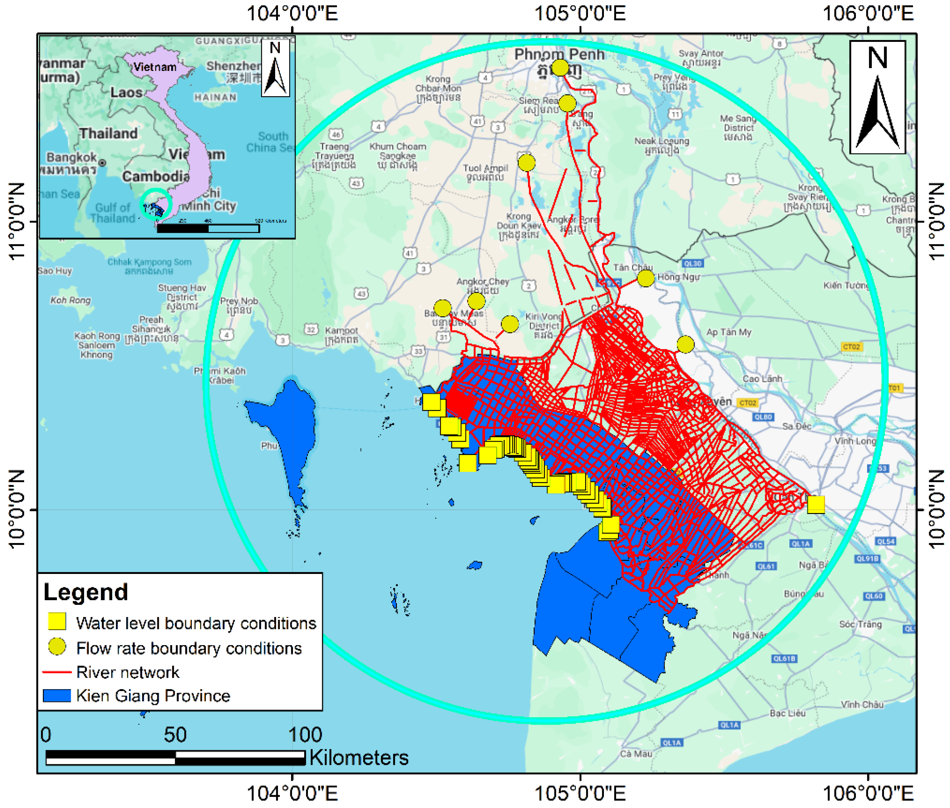
The model simulating the irrigation system of the Long Xuyen Quadrangle region was inherited from the SIWRP [
29]. In this model, the HD module is used to calculate the hydraulics for the model with unsteady flow conditions, as shown in
Figure 4. The river network system is simulated with 11,393 points, 1770 river branches, 4 dams, 987 pumping stations, and 2456 control structures. In this model, there are 57 boundary locations, including 8 flow boundary conditions and 49 water level boundary conditions.
Boundary and initial conditions:
Flow boundaries: including the flow at Chaktomuck, Stung-Takeo, Bassac, GT1, GT5, and GT6; water level boundaries: including the elevation data of water levels at the Can Tho, Xeo Ro, and Rach Gia stations.
In addition to the boundary condition data, the setup of initial conditions for model operation and the roughness coefficient series for rivers, canals, and ditches also influence the model’s operation process. Specifically, the initial condition was set with a water level elevation of +0.5 m (a commonly used initial condition according to the MIKE 11 user manual produced by the DHI), and the roughness coefficient series for the rivers, canals, and ditches in the study area ranged from 0.02 to 0.035, as referenced from TCVN 10716-2015 (the National Standard TCVN 10716-2015: Measurement of fluid flow in open channels cross-section method) [
31].
2.2.2. Model Calibration and Validation
- Model calibration: from 1 November 2018 to 30 April 2019 at Kien River and Ba Hon sluice gates (
Figure 5).
- Model validation in two periods: at Kien River and Ba Hon sluice gates.
+ Period 1 (natural flow regime): from 1 May 2019 to 31 October 2019.
+ Period 2 (flow regime influenced by human activities through the operation of sluice gates in the study area): from 1 July 2022 to 30 November 2022.
- Calibration parameter: Manning’s roughness coefficients were used to calibrate the model.
Figure 5.
Model calibration and validation locations.
Figure 5.
Model calibration and validation locations.
2.2.3. Model Performance Evaluation
To evaluate the results of the model, we not only visualized the measured and calculated data series through graphs but also assessed the model’s performance using the NSE (Equation (4)) and RMSE (Equation (5)) indices.
- -
NSE coefficient: The efficiency coefficient is used to measure the degree of correlation between the observed and simulated values. The classification of the NSE index to evaluate its level is shown in
Table 2 [
32,
33].
The NSE index is calculated using the following formula:
- -
RMSE: The RMSE is a measure used to assess the efficiency by evaluating the difference between the simulated values and the observed values. The RMSE value ranges from 0 to ∞, and the smaller the RMSE value, the more reliable the results [
34].
where
Oi is the observed value at time
i;
is the average of the observed values;
Pi is the simulated value of the model at time
i; and
n is the total observed values.
2.2.4. Operational Scenarios
Based on the operation procedure of the irrigation works system in the Long Xuyen Quadrangle region issued by the Ministry of Agriculture and Rural Development under Decision No. 3829/QĐ-BNN-TCTL [
30] dated 22 September 2021, the operation procedures for the sluice gates in the Long Xuyen Quadrangle region are established in the MIKE 11 model according to each type of gate valve and the specific conditions in the order shown in
Table 3.
Based on the opening and closing conditions of the gates, scenarios were developed in this study considering the operations of six sluice gates, including four sluice gates (Kien River, Sluice gate No.2, Sluice gate No. 9, and Luynh Huynh) belonging to the cluster 1 (BT1); and two sluice gates (Ba Hon and Vam Ray) belonging to cluster 2 (BT2) as shown in
Table 4.
3. Results
3.1. Model Calibration and Validation Results
Summary of calibration and validation results at two representative locations (Kien River and Ba Hon sluice gates) based on two indices: the NSE and the RMSE are shown in
Table 5. The details of the simulated and observed water levels in the calibration at the Kien River and Ba Hon sluice gates are presented in
Figure 6a and
Figure 6b, respectively.
The model calibration results show an NSE of 0.77 (Kien River) and 0.84 (Ba Hon), indicating high accuracy (NSE > 0.75). In addition, the RMSE is found to be 0.07 m and 0.06 m at the Kien River and Ba Hon sluice gates, respectively, indicating that the error values at both sluice gates are very small, implying a high level of reliability of the model simulation.
The details of the simulated and observed water levels in the validation process under two periods are presented in
Figure 7 and
Figure 8, respectively. According to the model validation results for period 1, it shows that the NSE coefficient is 0.78 at the Kien River and 0.85 at Ba Hon, both falling within the range of 0.75 to 1.00, which indicates that the model accuracy is very good. Moreover, the error (RMSE) is 0.09 m and 0.07 m at the Kien River and Ba Hon sluice gates, respectively. The very small RMSE values at both sluice gates indicate that the model has a high level of reliability.
Based on the validation results of the model in period 2, it shows the NSE of 0.79 and 0.85 at the Kien River and Ba Hon, respectively. Both fall within the range of 0.75 to 1.00. The values of RMSE of 0.09 m and 0.06 m at the respective sluice gates are very low, indicating that the model has a high level of reliability.
A comparison of the model validation results in period 2 with the calibration and validation results in period 1 indicates that the operational procedure in the model is quite similar to the actual operational procedure. The calibrated model can be applied to assess the fluctuation of water level inland and/or in the rivers under different operational scenarios.
3.2. Operational Scenario Simulation Results
According to the topographic map of the Long Xuyen Quadrangle region [
30], the natural ground elevation in the coastal areas of Kien Giang Province in the region averages between +0.5 m and +0.7 m MSL. Practical experience in regulating water levels for production and domestic needs during the dry and rainy seasons indicates that maintaining a water level of +0.6 m facilitates the water usage for residents in the coastal areas. Therefore, operating sluice gates to maintain the water levels at +0.6 m aligns with the actual needs of the local communities. When the water level drops below +0.6 m, residents can drain water via gravity; conversely, when the water level exceeds +0.6 m, water can easily flow into fields for agricultural use.
Generally, from the simulation results from the MIKE 11 model for the operational scenarios, the water levels in Scenarios 1, 2, and 3 are higher compared to the observed water levels and the baseline scenario. On the other hand, the water levels among the scenarios show inconsistent differences. The results of observed and simulated water level simulation at the sluice gates in the study area under different scenarios are summarized in
Table 6.
Specifically, the details are as follows:
Kien River sluice gate: With a water level >+0.6 m, Scenarios 1, 2, and 3 all show a higher frequency of operation compared to the baseline scenario and the observed data. Among them, Scenario 3 has the highest frequency of operation. With a water level elevation between +0.2 m and +0.6 m, the frequency of operation in Scenarios 1, 2, and 3 is lower compared to the baseline scenario and the observed data. Among them, Scenario 3 has the lowest frequency of operation. With a water level elevation <+0.2 m, the frequency of operation in Scenarios 1, 2, and 3 is lower compared to the baseline scenario, and the observed data. Among them, Scenario 3 has the lowest frequency of operation. It can be concluded that the operational scenarios at the Kien River sluice show that the average water level is more than twice as high compared to the observed data and the baseline scenario.
Ba Hon sluice gate: With a water level elevation >+0.6 m, Scenarios 1, 2, and 3 all show fewer operations compared to the baseline scenario and the observed data. Among them, Scenario 3 has the least frequency of operation, although the difference is not significant when compared to Scenarios 1 and 2. With a water level elevation between +0.2 m and +0.6 m, the frequency of operation in Scenarios 1, 2, and 3 is lower compared to the baseline scenario and the observed data. Among them, Scenario 2 has the fewest operations, although the difference is not significant compared to Scenarios 1 and 3. In addition, with a water level elevation <+0.2 m, the frequency of operation in Scenarios 1, 2, and 3 is higher compared to the baseline scenario and the observed data. Among them, Scenario 2 has the most operations, although the difference is not significant compared to Scenarios 1 and 3. It is clearly indicated that the average water level in the operational scenarios at the Ba Hon sluice is lower than the observed data and the baseline scenario.
Vam Ray sluice gate: For water levels exceeding +0.6 m, Scenario 3 has the highest frequency of occurrence, approximately twice as many as in Scenario 1 and Scenario 2. However, for water levels ranging from +0.2 m to +0.6 m, the frequency of occurrence across Scenarios 1, 2, and 3 does not differ significantly. However, Scenario 3 has approximately 100 fewer operations compared to Scenarios 1 and 2. Moreover, for water levels lower than +0.2 m, the number of operations of Scenarios 1 and 2 is higher than for scenario 3, in which Scenario 2 has the most appearances. This suggests that at low water levels, the factors associated with Scenario 2 have a stronger influence on the frequency of occurrence, possibly due to hydrological conditions or water regulation in the region. Scenario 3 has a lower frequency, suggesting that it is less likely to occur at such low water levels.
Luynh Huynh sluice gate: For water levels exceeding +0.6 m, Scenario 3 has the highest frequency of occurrence, approximately twice as frequent as Scenario 1 and Scenario 2. In addition, for water levels ranging from +0.2 m to +0.6 m, the frequency of occurrence across Scenarios 1, 2, and 3 does not differ significantly. However, Scenario 3 has approximately 250 fewer operations compared to Scenarios 1 and 2. However, for water levels below +0.2 m, the frequency of occurrence in Scenarios 1 and 2 is higher than in Scenario 3, with Scenario 1 having the highest number of operations.
Sluice gate No.2: For water levels exceeding +0.6 m, Scenario 3 has the lowest frequency of occurrence, approximately 50% less than for Scenarios 1 and 2, while for water levels between +0.2 m and +0.6 m, the frequency of occurrence across Scenarios 1, 2, and 3 does not differ significantly. However, Scenario 3 occurs 295 times more than Scenario 1 and 283 times more than Scenario 2. Moreover, for water levels below +0.2 m, the frequency of occurrence in Scenarios 1 and 2 is approximately 70% lower than in Scenario 3. Scenario 2 has the lowest frequency of occurrence.
Sluice gate No.9: For water levels exceeding +0.6 m, Scenario 3 has the highest frequency of occurrence, more than four times that of Scenario 1 and 2.5 times that of Scenario 2. For water levels between +0.2 m and +0.6 m, the frequency of occurrence across Scenarios 1, 2, and 3 does not differ significantly. Scenario 3 has the highest frequency of occurrence, while Scenario 1 has the lowest. For water levels below +0.2 m, Scenario 1 has the highest frequency of occurrence, while Scenario 3 has the lowest.
Based on the statistical results of the gate opening time, the frequency of gate operation (closing/opening) at the six sluice gates according to the operational scenarios is summarized in
Table 7. The details are as follows:
According to the three scenarios, it can be observed that at the sluices of Ba Hon, Vam Ray, Luynh Huynh, and Sluice Gate No. 9, the number of gate operations (opening/closing) for the forced closure gates is lower than for the automatic gates. However, at the sluices of Kien River and Sluice Gate No. 2, the number of gate operations for the forced closure gates is higher than for the automatic gates.
The number of hours that the gates are closed in Scenario 3 is higher than in Scenario 2, while the number of hours that the gates are open in Scenario 3 is lower than in Scenario 2. This indicates that the operation of the forced closure gates is more controlled and proactive compared to the automatic gates.
4. Discussion
This study highlights the significant impact of the sluice gate operation strategies on the water level regulation within the Long Xuyen Quadrangle. The MIKE 11 model calibration and validation results confirmed the model’s reliability, with NSE values ranging from 0.77 to 0.85 and RMSE values between 0.06 and 0.09 m at Kien River and Ba Hon sluice gates. This indicates that the model effectively simulates the hydrodynamic conditions and can be used to evaluate different sluice gate operation scenarios.
The operational scenario analysis revealed that Scenario 3, in which all the sluice gates were forcefully operated using hydraulic cylinders, maintained the water levels above +0.6 m more frequently than the other scenarios, particularly at the Kien River sluice gate. Forced closure gates allow for controlled water retention, which is crucial for irrigation and domestic water supply in coastal areas. In contrast, Scenario 1 (current operation) and Scenario 2 (fully automatic gates) resulted in lower water levels in some locations, indicating the potential challenges in meeting the water demand under these conditions. As discussed in previous studies [
25], the advantages of forceful operation using hydraulic cylinders are being proactive and prompt, less dependent on the water level conditions, having a simple design, and being easy to check for damage and repair the gates; however, there have been disadvantages such as the operation requiring of a lot of manpower, employees must be highly qualified and well trained, the inspection and repair of controlled electrical equipment must be carried out by highly qualified officials, there is a low clearance height (for boats), and in the cases of flood drainage, salinity control, and pollution discharge, operation must arrange human resources to directly close and open sluice gates in a timely and continuous manner according to the time of the tide, so as not to allow salt water to flow into the fields.
The frequency of sluice gate openings and closings varied across the different scenarios. At Kien River and Sluice-gate No.2, forced operation led to more frequent gate movements compared to automatic operation, ensuring greater control over water levels. However, at Ba Hon, Vam Ray, and Luynh Huynh sluice gates, automatic gates exhibited a higher frequency of operations. This suggests that the effectiveness of forced operation may depend on the site-specific hydrological conditions and that a uniform approach may not be suitable for all locations.
A comparison of the observed and simulated water levels further demonstrated that Scenario 3 provided more stable and controlled water regulation. Maintaining a water level around +0.6 m aligns with the practical needs of local communities, facilitating both agricultural irrigation and domestic water use. The findings suggest that while automatic gates can be effective in certain scenarios, proactive control using hydraulic systems offers greater adaptability in response to fluctuating water levels.
These results indicate that transitioning from passive to active sluice gate management can improve the water regulation efficiency. However, given that only 11.1% of sluices have been converted, further assessment is necessary to evaluate the long-term performance as additional gates are upgraded. Future research should explore the implications of sluice gate operation strategies on sediment transport, salinity intrusion, and climate change adaptation to develop a more comprehensive water management approach.
5. Conclusions and Policy Recommendations
This study assessed the performance of different sluice gate operation strategies on the water level regulation in the Long Xuyen Quadrangle, using a MIKE 11 hydrodynamic model calibrated and validated using field data from key locations such as the Kien River and Ba Hon sluice gates. While the principle that active sluice gate control can improve water management is generally accepted, this research provides detailed empirical evidence of how specific operation modes affect the water level regimes across multiple sites in a complex deltaic system.
The simulations showed that fully forced hydraulic operation (Scenario 3) was most effective in maintaining the water levels above +0.6 m MSL—an operational benchmark relevant for irrigation and domestic water use—particularly at the Kien River and Luynh Huynh sluices. However, the results also revealed that the benefits of active control are not uniform. In some locations, such as Ba Hon, automatic or mixed operation performed equally well or better. This suggests that a one-size-fits-all approach to gate management may be suboptimal. Instead, a differentiated strategy that tailors operation types to site-specific hydrological conditions and infrastructure capacity is likely to offer greater efficiency and resilience.
These findings carry important implications for ongoing sluice gate modernization efforts in the VMD. The transition from passive to active systems should prioritize the key control points where the hydrological variability is the greatest and where stable water levels are critical to agricultural productivity. SCADA systems—where already implemented—can play a pivotal role in enhancing the real-time responsiveness and reducing the reliance on manual operation. However, their deployment should be phased and strategically targeted, starting with the most hydrologically dynamic and operationally demanding sluices. In less complex areas, a combination of automatic and manual control may remain adequate, offering a cost-effective interim solution.
To ensure the long-term success of such transformations, attention must also be given to strengthening institutional and technical capacity. Trained personnel are essential for interpreting hydrological data, managing automated systems, and responding to real-time fluctuations, especially during extreme weather events or seasonal transitions. Embedding hydrodynamic modeling tools such as MIKE 11 into regular operational planning can further support adaptive management by forecasting water level changes under different flow and tide conditions. As more sluices are upgraded, continued model-based assessment will be critical for refining the gate-opening procedures and improving the overall system performance.
Looking ahead, future research should explore how different sluice gate operation strategies influence not only water level regulation but also related processes such as salinity intrusion, sediment transport, and downstream ecological impacts. These coupled dynamics are particularly relevant in a context of accelerating climate change and land use shifts. Moreover, integrating local community perspectives into decision making can help ensure that infrastructure investments are socially responsive and aligned with the on-the-ground needs.
In conclusion, while the general rationale for active gate control may be understood, this study contributes detailed, location-specific evidence on its hydrological impacts and operational trade-offs. It offers practical insights for optimizing gate operation strategies and advancing more adaptive, efficient, and climate-resilient water management in the VMD. This study provides evidence-based guidance to inform the phased transformation of sluice systems across the VMD, emphasizing flexibility, site specificity, and the integration of predictive hydrodynamic tools into routine operations.


 ,
, 


