1. Introduction
Given its vital role in supporting lives and economic activities, groundwater is extensively utilized for various purposes, including human consumption, agriculture, and industrial needs. Multiple activities may compete for groundwater in a region, and varying land utilizations can change groundwater dynamics, necessitating groundwater balance analysis [
1]. Large-scale extraction of groundwater involves pumping to meet the desired water supply. However, this expedient method can swiftly lead to groundwater depletion when the extraction rate surpasses the recharge rate, resulting in groundwater decline. In soil mechanics, a declining groundwater level translates to increased effective stresses on the soil skeleton, triggering consolidation of clayey materials and compaction of sandy ones within the aquifer system [
2]. Consequently, land subsidence and earth fissures become notable consequences. Earth fissures refer to long, deep ground cracks that form due to land subsidence caused by excessive groundwater extraction. These fissures can extend for kilometers, widen over time, and pose significant geotechnical hazards. The long-term depletion of groundwater has resulted in widespread geological hazards globally, including irreversible land subsidence, earth fissures, and property damage. Instances of such hazards have been documented in various regions worldwide, such as Brazil [
3], China [
4,
5], Indonesia [
6], the USA [
7,
8,
9], Mexico [
10], Ethiopia [
11], and the Kingdom of Saudi Arabia [
12].
Furthermore, earth fissures, a type of ruptured ground failure, have been recognized as preferential seepage pathways that can significantly impact environmental stability and contribute to secondary geohazards [
13,
14,
15]. These fissures facilitate water infiltration, potentially leading to secondary hazards such as soil erosion, piping, groundwater contamination, and landslides [
16,
17]. However, in some cases, they may also contribute to aquifer recharge [
14]. In aquifer vulnerability assessments, earth fissures and faults play a critical role in determining groundwater susceptibility [
18,
19]. Similarly, in landslide studies, preferential seepage paths, including earth fissures, can act as key triggering factors for slope instability [
20,
21]. Therefore, preventing and mitigating earth fissure formation is essential in extractive industries such as groundwater management, as well as oil and gas extraction, to minimize associated risks and environmental impacts.
Various mechanisms have been proposed in the literature to explain the formation of earth fissures induced by groundwater extraction, which can be categorized into four dominant mechanisms: tensile failure, shear failure, coupled shear and rotation, and coupled tensile and shear failure as follows.
1.1. Earth Fissuring Due to Tensile Failure
Earth fissures due to tensile failure include mechanisms such as the hydraulic force mechanism, the bending beam theory, and analytical models. This type of fissure is characterized by ground fractures without vertical offset. The hydraulic force mechanism, also known as the horizontal seepage stress hypothesis, is based on fluid motion generated by a pumping well [
22]. During the horizontal movement of water through soil, a tensional force develops in the soil medium due to fluid resistance, leading to the formation of earth fissures. When the pore water pressure in sedimentary soil declines, it results in the development of a contractional force within the dewatered soil layer, which can transform into a small crack [
23]. However, a case study on earth fissure movements in the Picacho basin, Arizona, USA, did not support this hypothesis due to the low correlation between groundwater gradients and horizontal movement [
24].
In 1969, Lee and Shen proposed the bending beam model to explain the formation of earth fissures [
25]. According to this model, a tension crack can form up to the neutral surface. Maximum horizontal strain accumulates around the topsoil layer above the zone of differential subsidence at the outer limits of a subsidence trough. Similarly, a rotating slab theory was developed to interpret earth fissuring induced by differential compaction above a buried bedrock scarp [
7]. According to this theory, earth fissures are likely to form on top of bedrock irregularities, with the top material layer acting as a singular unit [
7], or near points of maximum convex-upward curvature [
9,
26], extending the simplified beam theory for buried bedrock ridges. The basic premise of this theory is that earth fissures form when horizontal tensile strains range between 0.02% and 0.2%.
Sanford derived an elastic response of a homogeneous rock layer under vertical displacement, with or without horizontal displacement, demonstrating that vertical fractures can initiate under small horizontal strains ranging from 0.02% to 0.08%. He also conducted scale-model experiments, which yielded observations that closely agreed with his analytical solutions [
27]. In elasticity, there is a linear relationship between horizontal strain increment and changes in effective stresses. Consequently, substantial horizontal strain can accumulate with a continuous increase in effective stresses when the groundwater level keeps declining. The soil may fail by tension, following the maximum tensile strain criterion, or by shear, following the Mohr-Coulomb criterion, depending on which failure criterion is violated first. For failure to occur, the vertical and horizontal directions must align with the directions of the maximum and minimum principal stresses, respectively, resulting in vertical or subvertical earth fissures. Furthermore, earth fissuring related to groundwater withdrawal is believed to be a multi-step process. Differential movement, both horizontal and vertical, generates tensile zones at depth, which may migrate upward, forming a crack [
15].
1.2. Earth Fissures Due to Shear Failure
In the presence of a fault underlying a subsidence trough, the formation of fissures can be strongly influenced by the fault, as evidenced by dominant shearing deformation [
28,
29]. Critical stress path is used to interpret the slip mechanism of preexisting faults due to reservoir depletion in oil and gas extraction under homogeneous, isotropic, and linear poroelastic conditions. The stress path is defined based on the change in horizontal stress relative to variations in pore pressure and is applied within the framework of Jaeger and Cook’s frictional strength theory for faults [
30]. This type of earth fissure often presents notable vertical offsets. For example, the 13 km Shunyi earth fissure in Beijing, China, aligns with the pre-existing 100 km Shunyi-Liangxiang fault zone. Numerical studies have found persistent shear strain along the normal faulting of the fault and significant tensile strain across the fault, reaching 0.018% and 0.003%, respectively, after 91 days of pumping [
29]. Contributing factors to this earth fissuring mechanism under groundwater depletion include weaker material strength in the fault zone, thicker quaternary sediment on one side of the fault, the buried fault scarp on the other side, and activation of the fault [
12,
28,
29]. Dominant shearing can also be observed in earth fissures near mountainsides [
24] or above a bedrock ridge [
13].
1.3. Earth Fissures Due to Shear and Rotation in a Cosserat Continuum
Analyzing the state of stress on the soil skeleton reveals that it consists of compression, shear, and rotation, as the shear stresses on the vertical and horizontal planes are not equal due to the parabolic decline of the groundwater level. Consequently, a Cosserat continuum, rather than a Cauchy continuum, is more appropriate for simulating the stresses in such an environment because it accounts for the micro-rotation of infinitesimal soil elements [
31,
32]. This innovative approach provides an alternative interpretation of the earth fissuring mechanism. However, the analysis focused solely on the mechanics of the soil skeleton under effective stresses, ignoring the effects of fluid mechanics (hydraulic pressure). The direction of shearing and rotation resulting from unbalanced water pressure could counteract the shearing and rotation caused by effective stresses acting on the soil skeleton elements. Therefore, this effect must be included in the analysis to obtain a more comprehensive understanding of the earth fissuring process.
1.4. Earth Fissures Due to Coupled Shear and Tensile Failure Under Differential Compaction
The three major causes of earth fissuring due to differential subsidence are changes in the thickness of aquifer-aquitards, changes in soil compressibility, and changes in groundwater levels. The concept of differential subsidence-induced earth fissuring was first introduced by Feth [
33]. The main idea behind this theory was based on spatial variability of aquifer thickness, often coupled with bedrock abnormalities such as buried scarps [
29,
34], ridges [
13,
35], river courses, and active faults [
28,
29]. Investigations using multilayered extensometers have shown that land subsidence is primarily caused by the compaction of the primarily pumped aquifer and its adjacent aquitards [
4,
36]. The spatial variability of these layers results in differential subsidence and the formation of earth fissures. Coupled shear and tensional strains accumulate in the soil layer above an underlying bedrock irregularity, leading to differential movement of sedimentary layers when their limits are exceeded. In summary, both vertical and horizontal differential movements can induce earth failures. Earth fissuring is more likely to occur when bending combines with simple shearing or coupled shear and tensile failure [
37].
Earth fissures may harm lives and damage properties (farmland, house, building), infrastructure (road, bridge, pipeline, waterway), and the environment (pollution, ecosystem, biodiversity) [
12,
24,
38]. Geological hazards resulting from groundwater depletion are prevalent in densely populated regions across China, including the Beijing-Tianjin region [
29,
39], Xi’an [
40], and the Yangtze River delta region [
36,
38,
41]. In the jurisdiction of Jiangsu Province that is part of the Yangtze River delta region, previous studies include land subsidence and rebound in the Changzhou City area [
4,
36] and earth fissures in Jiangsu Province [
13,
35]. The present study focuses on the western area in Wuxi City of Jiangsu Province, China. The area is of unique significance as the local epicenter of the groundwater depression funnel at Qianzhou-Shitangwan coincides with the regional epicenter of the groundwater depression funnel in the Yangtze River delta, experiencing the most significant decline in groundwater level in the region. The study utilizes Shitangwan as a case study to investigate the efficacy of an integrated methodology in earth fissure investigation in Wuxi. This integrated approach incorporates multilayered extensometers, crack meters, advanced geophysical explorations, conventional field surveys, excavation, geological drilling techniques, and analytical methods.
2. Geological Setting
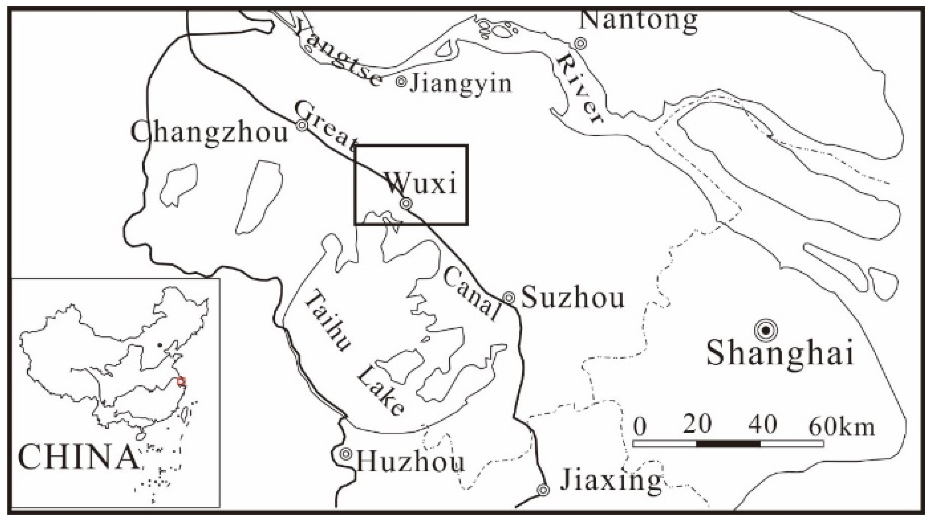
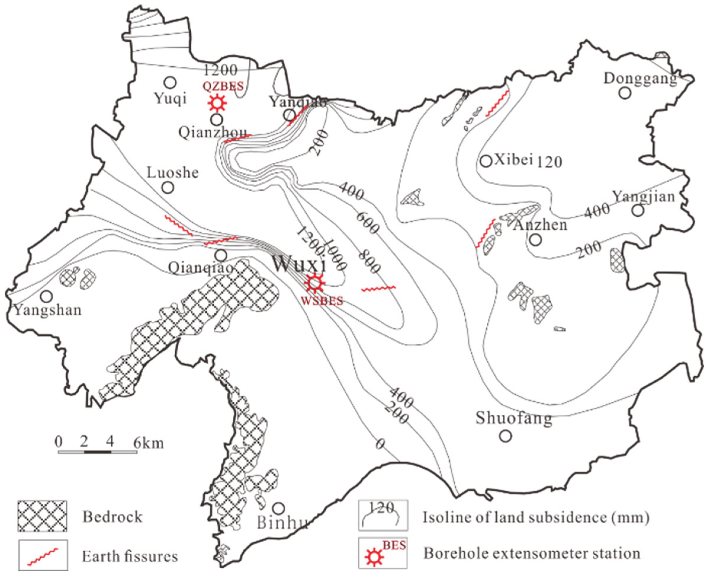
Wuxi, Jiangsu Province, China, lies in the western Yangtze River Delta (
Figure 1), featuring low-lying terrain (2.0–4.2 m elevation) and an extensive surface water network. The phreatic surface is typically 0.5–1.0 m below ground level. Subsurface sediments mainly comprise Quaternary deposits, including alluvial lacustrine silt clay and river lacustrine silt clay.
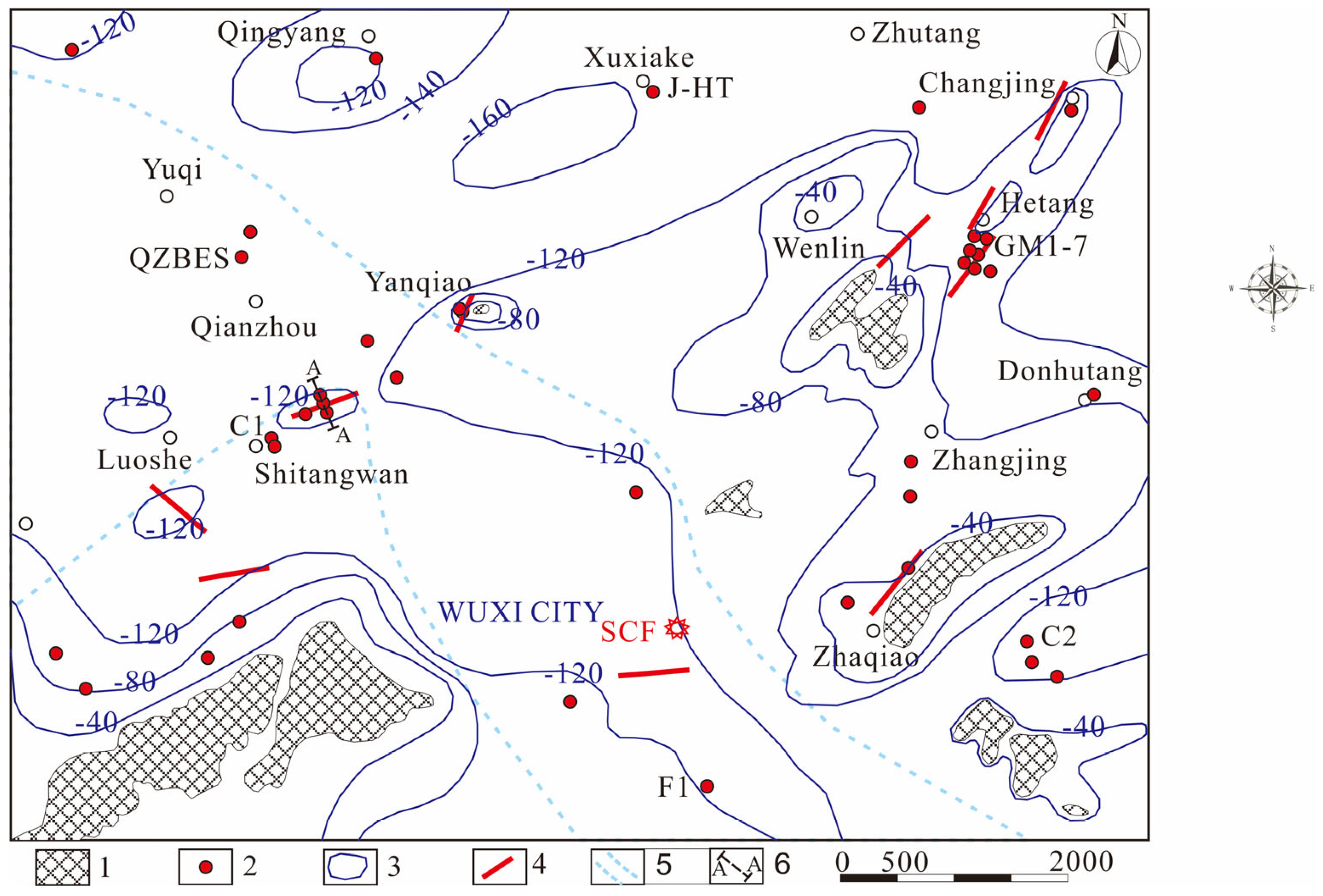
Shitangwan, a town in western Wuxi, lies within a geologically complex area.
Figure 2 illustrates the region’s bedrock topography and earth fissure distribution. Despite the flat surface terrain, bedrock isolines reveal a rugged subsurface, with depths exceeding 120 m in basins and exposed outcrops in mountainous areas. An ancient river channel, 8–10 km wide, traverses the area, containing a thick sand layer that forms the second confined aquifer. Beneath the Shitangwan earth fissure, the buried southern riverbank consists of Upper Devonian quartz sandstone, shaping a northeast-oriented (65–75°) bedrock ridge at depths of 50–100 m.
Figure 3 shows a geological profile through the Shitangwan earth fissure, with Quaternary sediments comprising clay, silty clay, silt, fine sand, coarse sand, and gravelly clay layers. Four aquifers have been identified in the Yangtze River delta region: one unconfined (UCA) and three confined (CA1, CA2, CA3) [
4]. The UCA, CA1, and CA2 aquifers are identified at the Shitangwan site.
The CA1 aquifer consists of silt, silt sand, and fine sand from upper Pleistocene marine and alluvial lake facies, with low-quality groundwater.
CA2 typically has a thickness of 30 m and is found 90 m bgl north of the bedrock ridge, though its thickness varies with topography. At borehole C1 in Shitangwan, 2000 m west of WF1, CA2 is 58 m thick, composed mainly of fine sand, at 75.45 m bgl. At borehole WF2, CA2 spans 90.4–115 m bgl with a thickness of 24.6 m, consisting of dark gray silt, fine sand, and coarse sand, with a thin clay layer between 103.2 and 103.65 m bgl. The underlying aquitard, from 105 to 120 m bgl, is dark gray-brown silt clay interspersed with fine sand. Bedrock is encountered at 123.1 m bgl. At borehole S01, CA2 is 25.42 m thick at 77.4 m bgl, with a gradual increase in grain size downward. CA2 is absent south of the bedrock ridge, as confirmed by boreholes S02, S03, and WF1, which reach 116 m bgl.
3. Methodology
In addition to compiling regional first-class leveling survey data and historical groundwater extraction records, key methodologies included field monitoring using multilayered borehole extensometers to track strata compression and groundwater levels, as well as static level gauges and crack meters for earth fissure monitoring. Furthermore, advanced geophysical techniques, such as 3D seismic surveys and transient surface wave exploration, were utilized alongside conventional geological investigations, trench excavations, and profile drilling.
3.1. Qianzhou Borehole Extensometer Station (QZBES)
A borehole extensometer station was established in Qainzhou, Wuxi, in 2002 (see
Figure 2), strategically positioned at the center of the regional groundwater depletion funnel. The QZBES comprises one bedrock borehole extensometer, six layered borehole extensometers, one benchmark, and one observation well to CA2, designed to monitor strata compression and groundwater levels in the CA2. The bedrock extensometer is securely anchored in fine sandstone. The multilayered measurements of land subsidence enable detailed analysis of strata compression to gauge the spatial and temporal variations. The stratification of the Quaternary strata at the QZBES is as follows:
0–15.10 m: soft silty clay;
15.10–27.20 m: hard to plastic clay;
27.20–34.30 m: soft silty clay;
34.30–57.60 m: hard to plastic clay;
57.60–63.50 m: clayey silt to fine sand (CA1);
63.50–87.80 m: hard silty clay;
87.80–94.60 m: silty clay inter-layered with silt-fine sand;
94.60–139.80 m: medium-coarse sand and medium to fine sand (CA2);
139.80–157.20 m: hard silty clay.
3.2. Earth Fissure Monitoring
A pair of static-level apparatus and a crack meter was installed across the main fissure of the Shitangwan earth fissure to monitor the differential subsidence across the fissure and the aperture of the fissure over time. These instruments were installed on bases positioned across the earth fissure, spaced 14.9 m apart in 2004. This installation represents the first automated station designed to monitor both horizontal and vertical relative deformation of the hanging wall and footwall of an earth fissure within the Yangtze River delta region. The static level gauge serves to measure the differential subsidence between the two sides of the fissure, while the crack meter is utilized for measuring horizontal deformation across the fissure.
3.3. Geophysical Investigation
3D seismic exploration is used to investigate the geological profile across the earth fissure zone at Shitangwan, complementing five borehole drilling and trench excavation across the fissure.
Transient surface wave exploration is applied to accurately depict the topography of the Shitangwan earth fissure. The exploration area predominantly consists of farmlands interspersed with numerous ditches, ponds, and scattered houses. To establish a comprehensive geophysical detection network, five lines were deployed, comprising three north–south lines and two east–west lines. The spacing between measuring points within the earth fissure zone was set at either 48 m or 24 m. In total, the exploration lines span a length of 4.9 km and encompass 133 surface wave exploration points. The transient surface wave exploration utilized OYO’s Mcseis-1500 improved shallow seismograph multi-channel wave acquisition system in conjunction with the high-damping 4 Hz detector manufactured by Xi’an Petroleum Instrument Factory. The parameters were meticulously optimized, with settings configured for an 8 m offset, 4 m track spacing, 0.25 ms instrument sampling interval, 512–1024 ms record length, and a combined excitation mode employing both hammer and weight falling techniques. Geodetic measurements of the coordinates and relative elevations of the measuring points were conducted using the Topcon GTS-711 total station.
4. Groundwater Depletion and Recovery
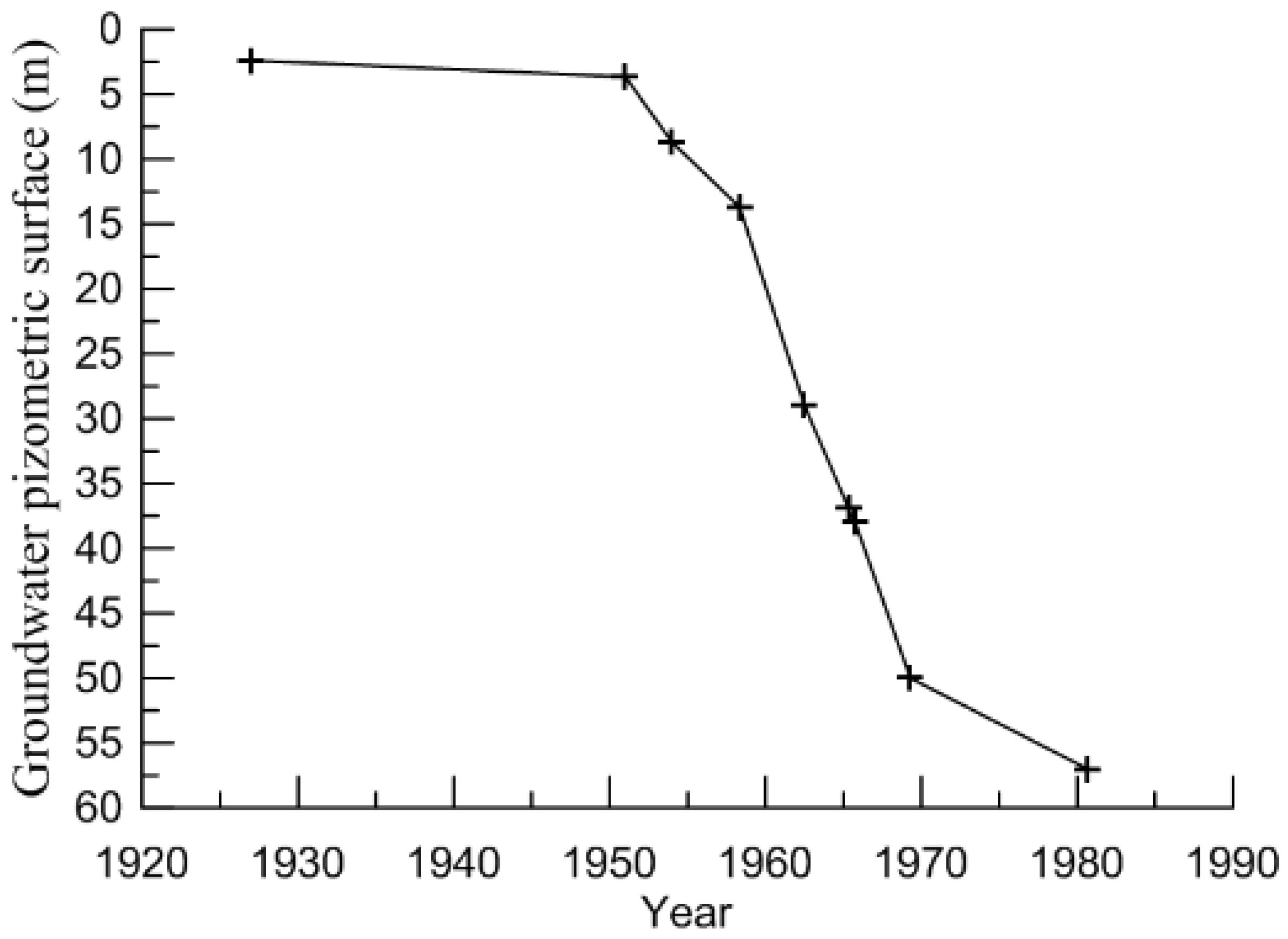
Before 1980, groundwater pumping was mainly in municipal Wuxi City, with only two wells in west Wuxi. From the 1920s to the 1950s, CA2’s groundwater level remained stable. However, from the 1950s to the 1970s, increased demand led to a rapid decline, dropping from 3 m bgl in 1953 to 60 m bgl by 1981, averaging 2.0 m per year (see
Figure 4).
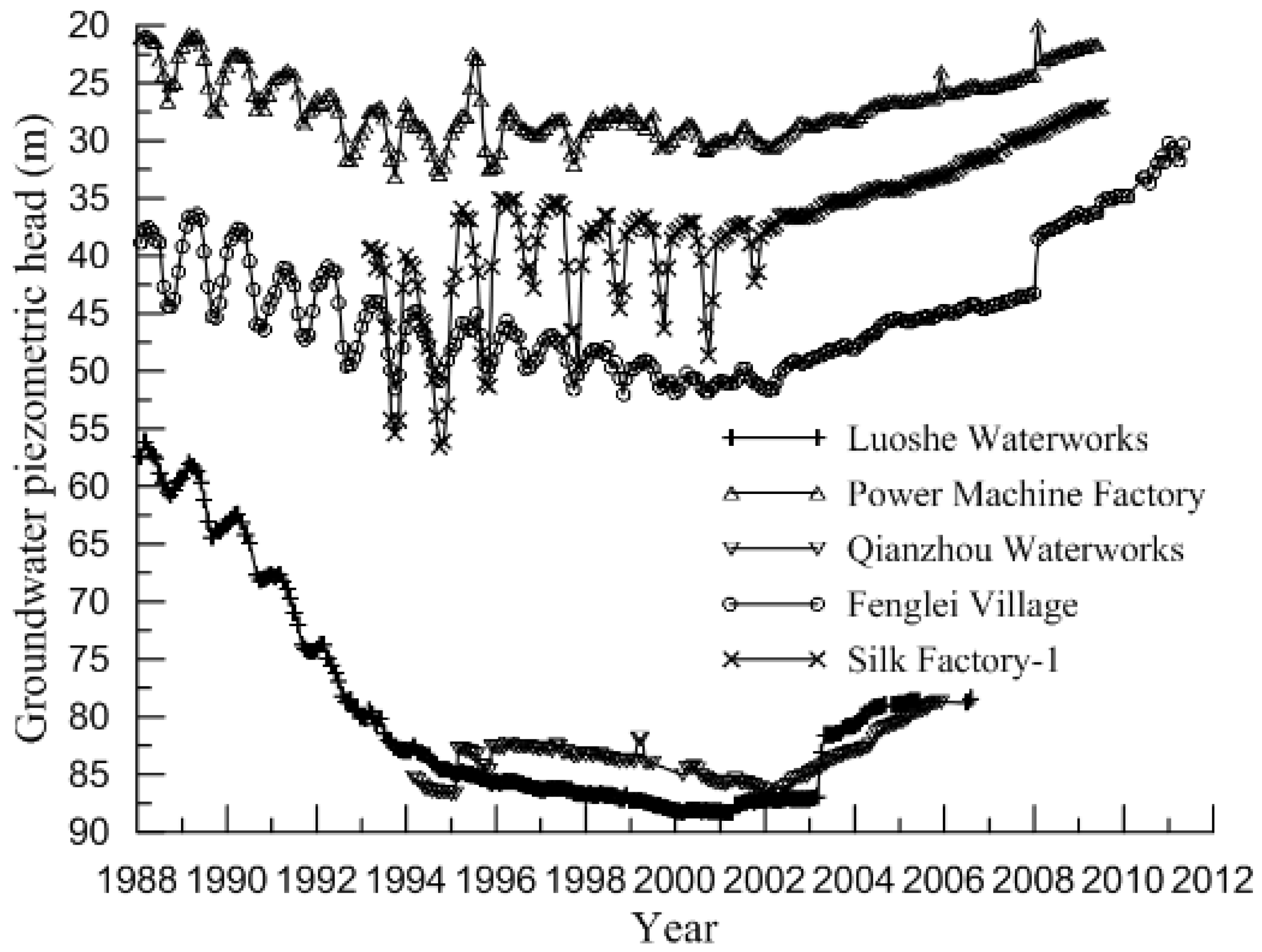
Since 1980, rapid industrial expansion led to severe surface water pollution, increasing reliance on CA2 groundwater. By 1988, the groundwater level in Luoshe dropped to 57 m bgl, reaching 60 m bgl in 1989 when the Shitangwan earth fissure formed (
Figure 5). In Shitangwan, 33 deep wells pumped up to 20 million m
3 annually, causing a rapid decline of 5–6 m per year.
Despite restrictions on groundwater extraction from 1990, CA2 levels continued to drop, reaching 85 m bgl in Luoshe by 2000. Annual pumping exceeded 50 million m
3 in west Wuxi and 10 million m
3 in Luoshe, creating a depletion funnel over 300 km
2. The lowest recorded level, 88.24 m bgl, was reached in Luoshe in 2001, marking the deepest depletion in west Wuxi and the Yangtze River Delta. Since 2003, groundwater levels have steadily recovered, returning to 1980s levels in some areas (
Figure 5).
5. Effects of Groundwater Depletion and Recovery
5.1. Land Subsidence and Rebound in Wuxi
Signs of land subsidence in Wuxi City emerged in the late 1960s, intensifying as groundwater pumping expanded in the 1970s. A maximum subsidence rate of over 40 mm/a was recorded, with the First Cotton Factory accumulating more than 700 mm of subsidence by 1980.
Despite reduced groundwater pumping in urban Wuxi since the 1980s, groundwater levels continued to decline at 1.0 m/a, maintaining a subsidence rate of 20 mm/a. Meanwhile, subsidence in west Wuxi escalated due to rapid groundwater depletion, exceeding 100 mm/a in the late 1980s and reaching 120 mm/a in the 1990s. By 1990, the subsidence center had shifted to Qianzhou, Luoshe, and Shitangwan, with cumulative subsidence reaching 1000 mm and a 300 km
2 area enclosed by 600 mm subsidence isolines (
Figure 6).
Enhanced supervision of groundwater pumping in the 1990s slowed groundwater drawdown and reduced land subsidence rates (
Figure 5). From 1980 to 1999, Shitangwan experienced 1844 mm of subsidence, averaging 97 mm/a. By 2006, cumulative subsidence reached 1994 mm, but the rate had declined to 21.4 mm/a (1999–2006). Similarly, subsidence in Qianzhou and Yuqi remained above 20 mm/a (2000–2003), dropped below 10 mm/a in west Wuxi by 2005, and was 2.7 mm/a at the South Station borehole extensometer in 2007.
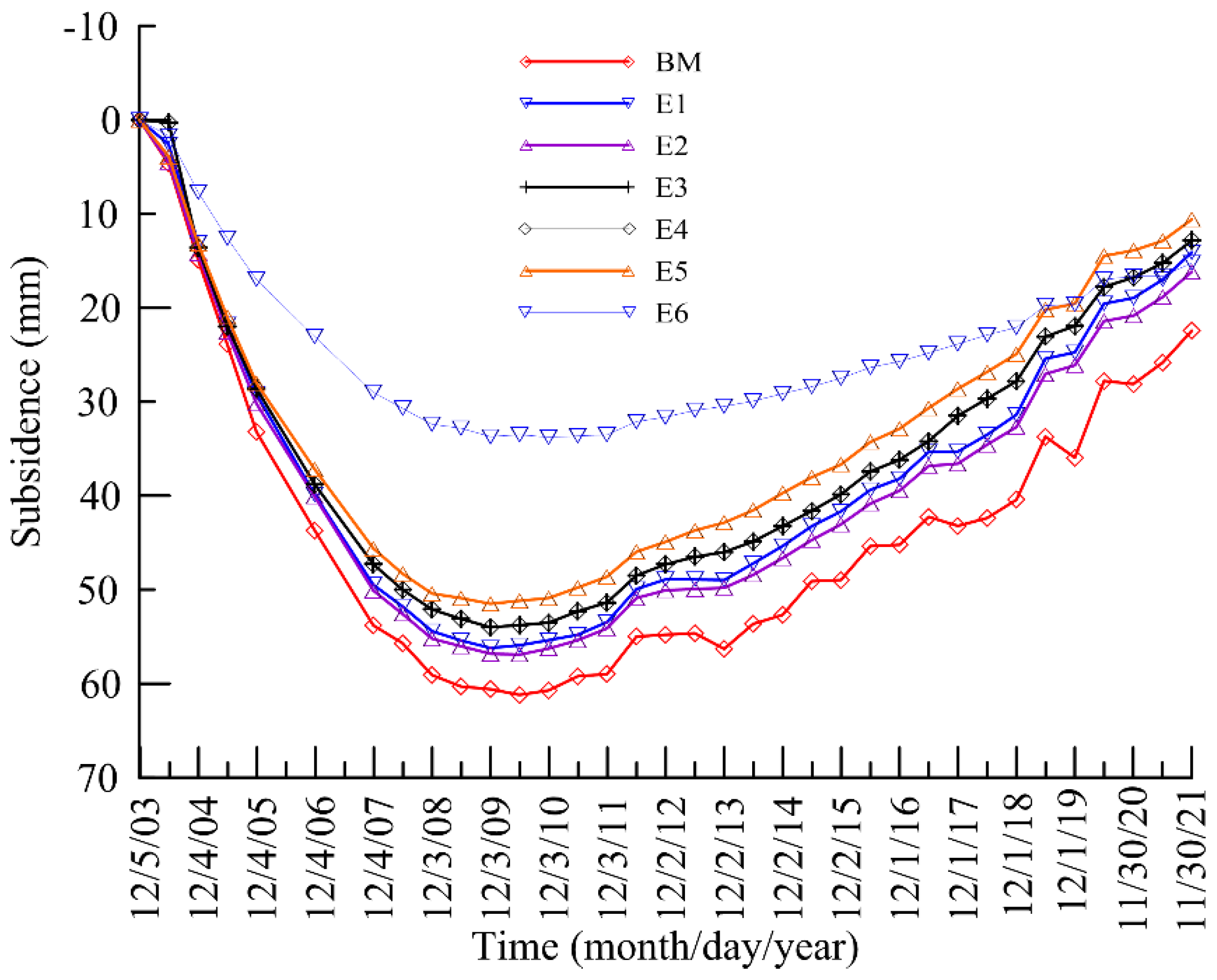
Figure 7 presents the monitored multilayered land subsidence data at QZBES from 2003 to 2021, while
Figure 8 illustrates the resulting strata compression. In these figures, BM denotes the benchmark, and E1–E6 represent extensometers located at stratum interfaces. From 2003 to 2009, land subsidence at QZBES totaled 60 mm before stabilizing, while groundwater levels showed significant recovery (
Figure 5). However, land rebound has been minimal, reaching only 38 mm (less than 2% of total subsidence) due to irreversible plastic compression [
2,
36].
Figure 8 and
Table 1 demonstrate that different strata present significant temporal variation in compressibility and rebound corresponding to the groundwater recovery in CA2. Deep strata, particularly CA2 and adjacent aquitards, responded more to groundwater recovery.
Overall, Wuxi’s subsidence trends parallel Changzhou’s. Groundwater levels took over a decade to recover to 1980s levels, while land rebound lagged by 11 years, with a decade of rebound accounting for less than 3% of total subsidence [
36].
5.2. Earth Fissures in Wuxi
By 1999, Wuxi had experienced seven earth fissures, indicating a relatively high density of occurrences within the regional land subsidence trough of the Yangtze River Delta. This phenomenon is attributed to several factors, including significant groundwater depletion, extensive land subsidence, and the irregular bedrock topography, which consists of ancient river valleys and mountainous terraces (
Figure 2), along with the heterogeneous structure of the Quaternary strata (
Figure 3).
Table 2 summarizes the earth fissures in Wuxi.
5.3. Property Damage at Shitangwan
In addition to land subsidence and earth fissures, property damage is frequently observed in the region. The Shitangtan earth fissure has caused significant damage to farmlands, houses, and roads and has altered surface runoff patterns. In Yinguoan Village, 15 houses were affected, with three suffering severe damage due to the fissure, along with cracked concrete pavement and disrupted farmland.
Figure 9 shows a house severely impacted by the primary fissure, with two groups of cracks extending across the side wall.
6. Results and Discussions on the Shitangwan Earth Fissure
The Shitangwan earth fissure was first observed in May 1991, extending in a northeast direction from Yinguoan to Qinxiang. This fissure zone consists of a primary crack and numerous secondary rifts running parallel to it on the north side (see
Figure 2 and
Figure 6). The primary crack stretches over 2000 m, while the secondary rift zone spans 50–60 m in width. The formation of this fissure is attributed to differential land subsidence caused by the decline in groundwater levels within CA2. Initially, micro-cracks appeared on the ground surface, oriented perpendicular to the steep gradient of land subsidence. As subsidence progressed, these cracks gradually expanded, eventually developing into elongated linear faults. These faults are characterized by scarps ranging from 200 to 500 mm in height on the footwall, located on the south side of the fissure.
6.1. Investigations Across the Shitangwan Earth Fissure
The activity of the earth fissure is closely linked to the rate of land subsidence. The most dynamic phase of the fissure occurred between 1991 and 1995. During this period, the fissures underwent progressive growth: the width expanded from mere millimeters to 10–25 mm, the main fissure lengthened from hundreds of meters to over 2000 m, and the degree of differential subsidence along the main fissure also increased. Most of the fissure segments extend across farmlands. Survey findings indicated that the fissure scarp offset approximately 500 mm with the hanging wall slipping down. The fissure width ranged from 30 to 80 mm, with a visible depth of 200 to 400 mm.
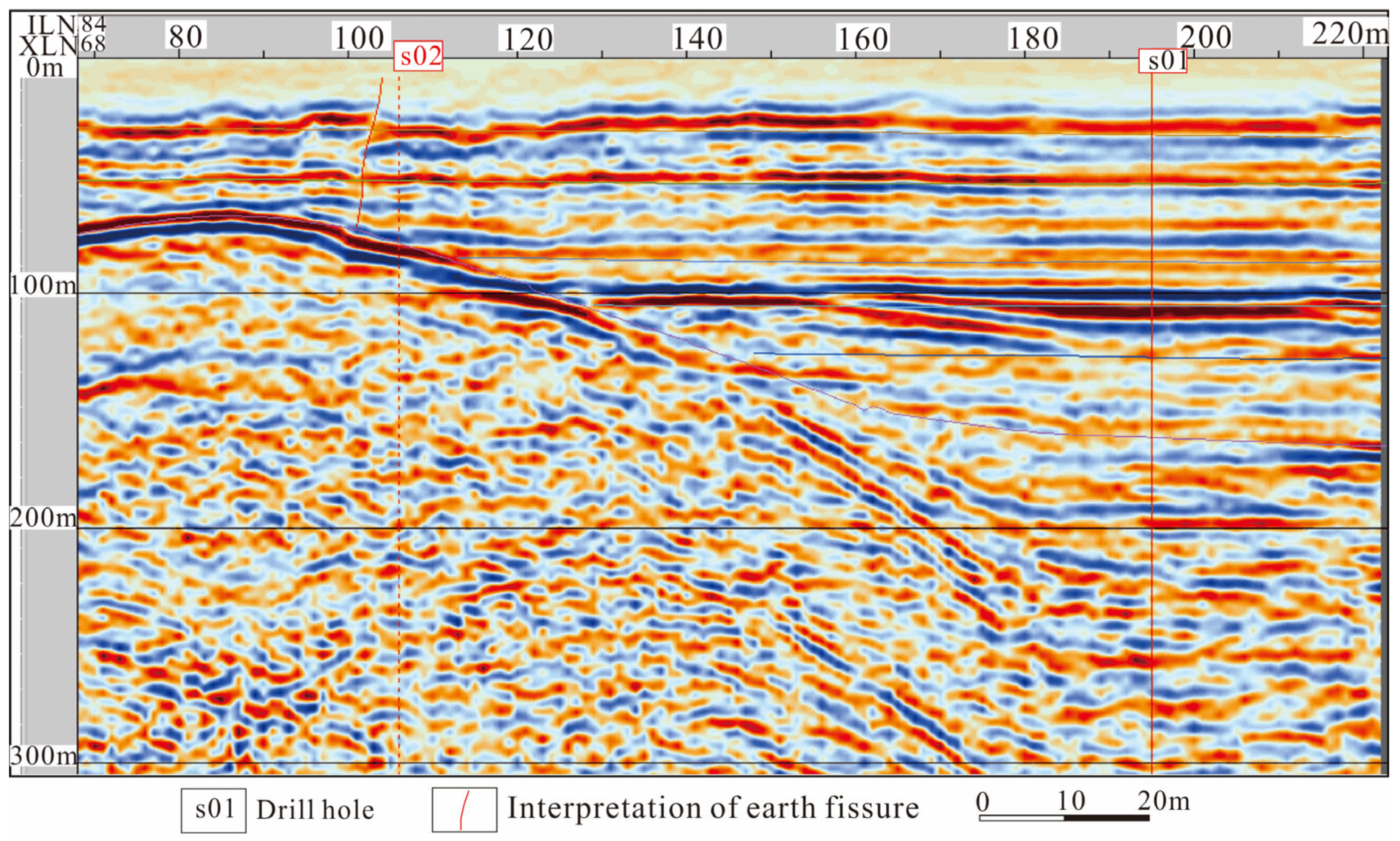
The 3D seismic exploration image depicted in
Figure 10 reveals the presence of a buried bedrock ridge beneath both the fissure and the house in
Figure 9. The geophysical parameters of various lithological types were derived from transverse wave velocity (v
s), longitudinal wave velocity (v
p), and logging data collected from the S01 borehole. Utilizing 3D seismic exploration data, the buried bedrock ridge is in the NE-NEE direction [
42]. This ridge generally exhibits higher elevation in the southwest and lower elevation in the northeast, with a burial depth ranging from 50 to 100 m bgl. In the southeast, the depth of the foothills is less than 120 m bgl, while in the northwest, it ranges from 120 to 130 m bgl. The ridge displays a relatively symmetrical profile, featuring a north-slope angle of 12° and a south-slope angle of 11°. The 3D spatial distribution of the earth fissure is clearly delineated through the analysis of broken reflection layers, the conversion of reflection wave energy, and seismic event mutations (
Figure 10). The direction of the earth fissure is predominantly NE-NEE, aligning with the direction of the buried ridge. The fissure is interpreted as fractured from the surface to the bedrock from the seismic image (the red line near borehole S02 in
Figure 10).
Five boreholes were drilled perpendicular to the fissure, forming the geological profile illustrated in
Figure 3. The bedrock hill emerged as a significant geological feature influencing the soil strata structure on either side of it: CA2 was prominently developed on the northern side, whereas it was notably absent on the southern side [
38].
To reveal the characteristics of the primary fissure affecting the soil mass, a trench was excavated in the central segment of the fissure, similar to the approach taken at the Hetang earth fissure [
35]. Oriented at 160°, nearly perpendicular to the main fissure, the trench aimed to expose the fissure’s impact. The interface of the soil layers was faulted by 200 mm, with the north side down-slip. Although the surface of the fissure was not clearly discernible, four nearly parallel vertical cracks disturbed the soil mass. Upon excavating the trench to a depth of about 1.0 m, spring water gushed out from the cracks, indirectly indicating that the fissure had cut through the soil mass, and had become a preferential seepage pathway between strata.
6.2. Transient Surface Wave Exploration
The resultant three-dimensional image of relative elevations vividly depicts the micro-topographical disparities on either side of the earth fissure (
Figure 11). The terrain exhibits a predominantly flat profile, with ground elevation differences ranging from 2 to 3 m, gradually decreasing from south to north. Most of the area (green and yellowish zones in the figure) is below the reference level with negative elevations, and hills and the northeast corner (blue zones in the figure) are slightly above the reference level of positive elevations. Furthermore, the north side of the earth fissure experienced subsidence ranging from 0.5 to 0.8 m in relation to its south side, with the maximum opening of the main fissure measuring several centimeters.
6.3. Monitoring of the Shitangwan Earth Fissure
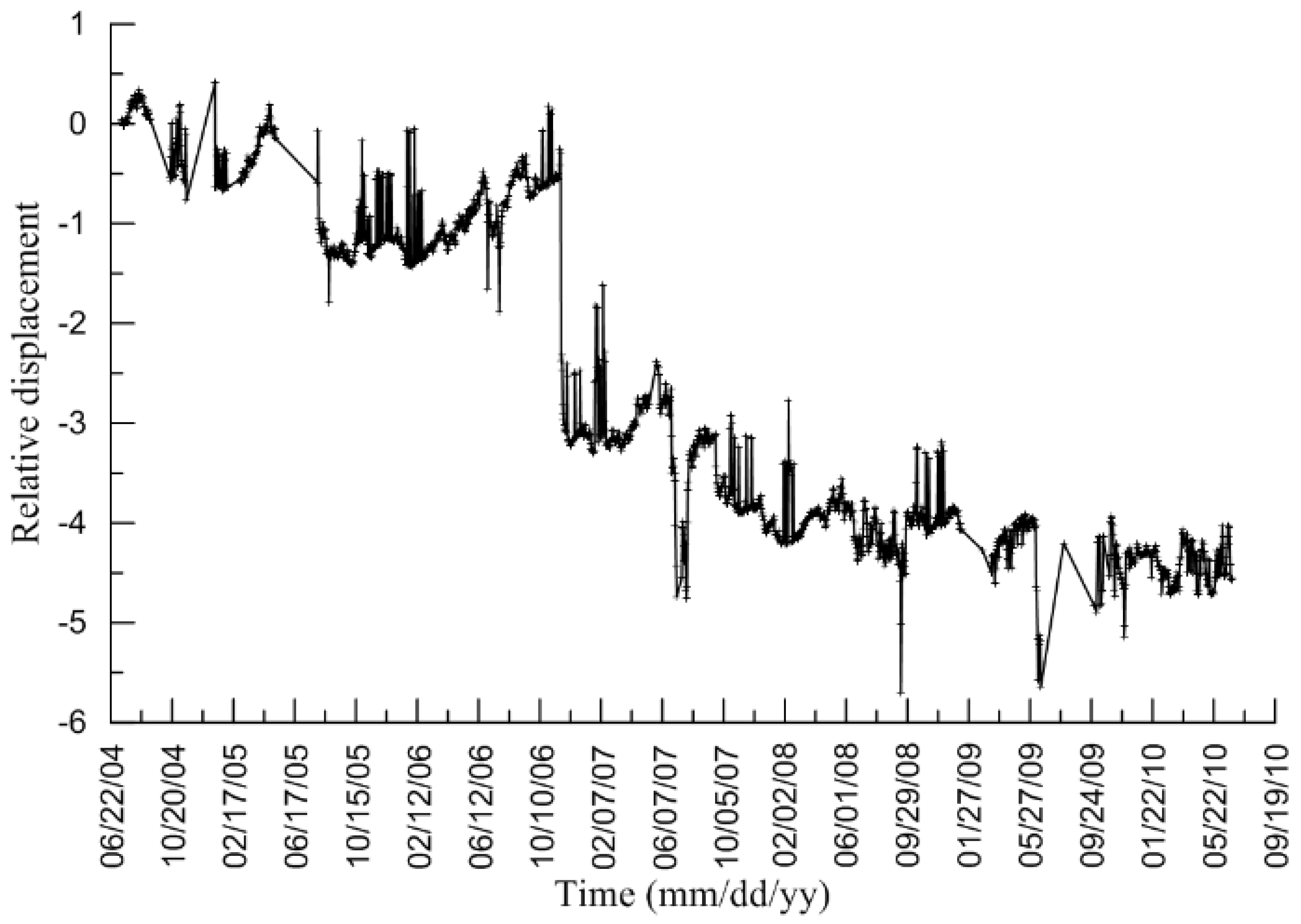
As surveyed, a 500 mm scarp was formed along the main fissure before 2004, with the north side slipping relative to the south side, and the average rate of differential settlement was estimated at 38.46 mm/a from 1991 to 2003. Since 2004, the earth fissure deformation has been continuously monitored using a pair of static level apparatus and a crack meter.
Figure 12 illustrates the monitored vertical relative deformation between the two sides of the fissure from 2004 to 2012. The measured vertical relative deformation increased from 5 mm at the end of 2004 to 12 mm by the end of 2009, averaging approximately 2 mm/a during this period. Notably, the deformation was nearly negligible since 2009, coinciding with the cessation of earth fissuring since that year.
Figure 13 depicts the horizontal displacement monitored across the earth fissure from 2004 to 2010. Lateral cracking ceased after 2009, consistent with the relative vertical displacement across the fissure (
Figure 12). The behavior resembled that of a spring, exhibiting some elastic expansion and contraction around the neutral axis since 2009.
6.4. Deformation Compatibility Analysis
The differential subsidence was estimated at 1100 mm between the earth fissure zone and the local trough center 328 m away. The bedrock ridge is 73.6 m high relative to the bedrock level at the trough center. Considering deformation compatibility, the horizontal normal strain is ε
x = 0.335%. Typically, the tensile strain required for the development of an earth fissure ranges from 0.02 to 0.2% [
26,
35]. This indicates that the occurrence of the Shitangwan earth fissure is inevitable.
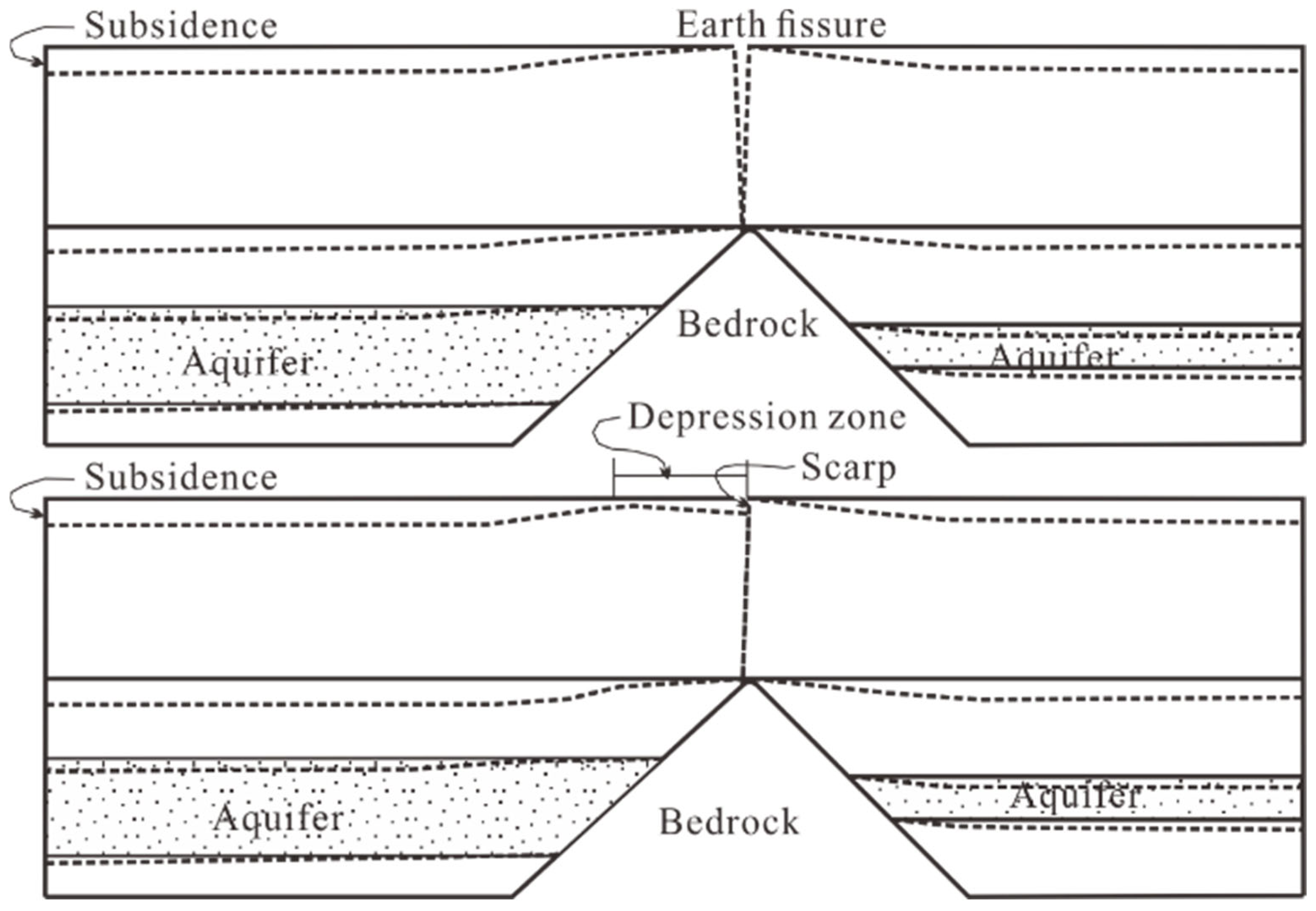
The mechanism underlying the formation of the earth fissure is depicted in
Figure 14, focusing on the Shitangwan earth fissure. The primary contributor to land subsidence is the depletion of groundwater in CA2. Differential subsidence occurring across the bedrock ridge can induce tension cracks at the ground surface, akin to a slab bending over the ridge [
7]. As a result, these cracks gradually enlarge over time. Subsequently, the hanging wall undergoes greater subsidence relative to the footwall, primarily due to the heterogeneous consolidation of the soil profile resulting from the depletion of groundwater. Concurrently, scarps begin to form along the main fissure due to the vertical shearing of the differential strata compressibility [
24]. Under the coupled action of tension and shearing, numerous secondary rifts or soil failures occur when the ground keeps subsiding. Finally, a local depression zone develops over the ridge when the failed soil mass backfills the voids of the fissure (the lower illustration in
Figure 14).
7. Conclusions
Long-term excessive groundwater depletion in Wuxi, China, has led to significant regional land subsidence, earth fissures, and damage to farmlands, roads, and residential properties. Through a comprehensive literature review, this study identified gaps in understanding the mechanisms driving earth fissuring due to groundwater decline and potential secondary geohazards if earth fissures act as preferential seepage paths. The research aimed to analyze the formation and progression of earth fissures in the Shitangwan area using a multifaceted investigative approach. Key methodologies included field monitoring with multilayered borehole extensometers to track strata compression and groundwater levels, as well as static level gauges and crack meters for earth fissure monitoring. Additionally, advanced geophysical techniques, such as 3D seismic surveys and transient surface wave exploration, were employed alongside conventional geological surveys, excavation, and profile drilling to develop a holistic understanding of the subsidence and fissuring processes induced by groundwater extraction. Key findings from this study include:
Land Subsidence Recovery: Groundwater levels in Wuxi are gradually recovering after banning groundwater extraction, leading to an observed rebound in land elevation. However, subsidence varies both spatially and temporally, with deep strata (CA2 and adjacent aquitards) more responsive to the groundwater recovery with a delayed time lag of approximately a decade.
Cessation of Earth Fissuring: Monitoring results indicate that earth fissuring has ceased at the Shitangwan earth fissure, with zero differential subsidence and lateral cracking recorded across the primary fissure. The cessation of the earth fissuring temporally correlated with the cessation of land subsidence in the area, supporting the conclusion that the earth fissure is resultant from the differential land subsidence.
Influence of Subsurface Bedrock and Strata Heterogeneity: The formation of earth fissures is strongly influenced by the rugged bedrock topography, ancient river valley formations, and heterogeneous strata. These factors exacerbate differential strata consolidation/compression caused by excessive groundwater decline.
Mechanisms of Fissure Formation: Earth fissures at Shitangwan developed through a combination of mechanisms:
Rotation-Slab Theory: Differential land subsidence near subsurface bedrock ridges induces heterogeneous soil movements, generating horizontal tensile stress/strain that leads to surface cracking once the tensile strain threshold is exceeded.
Sandford’s Model: Dominant deep strata compression creates complex displacement patterns, where variations in vertical compression at depth induce horizontal tensile strain at the ground surface.
Non-Tectonic Faulting: Continued groundwater decline exacerbates differential strata compression, leading to fault-like shearing and the formation of surface scarps associated with differential subsidence rates.
Water Pressure Counteraction Model: Differential water pressure variations counteract differential effective stresses in the soil skeleton, inducing upward bending and facilitating earth fissure initiation at zones of highest differential variations.
Despite the extensive data collected, some limitations remain. This study focuses on a single case study, and while the findings offer valuable insights, further research is needed to assess the applicability of the identified mechanisms across diverse geological settings.
The findings have significant implications for sustainable groundwater management, landform protection, and urban planning in subsidence-prone regions. By enhancing the understanding of fissure formation mechanisms, this study provides a foundation for strategic groundwater utilization and management policies. These insights contribute to advancing land stability assessments and strengthening the resilience of critical infrastructure in areas affected by land subsidence and earth fissures due to groundwater extraction.
Author Contributions
This article is substantially contributed by the following authors. Conceptualization, methodology, validation, investigation, data curation and funding acquisition, G.-Y.W., J.-Q.Z., J.Y., F.-G.G. and J.-Q.W.; formal analysis, G.-Y.W., J.-Q.Z., G.G.Y. and D.Z.; writing—original draft preparation, G.-Y.W.; writing—review and editing, G.-Y.W., G.G.Y. and D.Z. All authors have read and agreed to the published version of the manuscript.
Funding
This research was funded by the National Natural Science Foundation of China (Grant Nos. 41772327 and 41572271) and supported by funds from the Special Program for the Public Research of the Ministry of Land and Resources of China (Grant No. 201411096).
Data Availability Statement
The original contributions presented in this study are included in the article. Further inquiries can be directed to the corresponding author(s).
Conflicts of Interest
The authors declare no conflicts of interest, and the funders had no role in the design of the study; in the collection, analyses, or interpretation of data; in the writing of the manuscript; or in the decision to publish the results.
References
- Lu, Y.; Dai, L.; Yan, G.; Huo, Z.; Chen, W.; Lan, J.; Zhang, C.; Xu, Q.; Deng, S.; Chen, J. Effects of various land utilization types on groundwater at different temporal scales: A case study of Huocheng plain, Xinjiang, China. Front. Environ. Sci. 2023, 11, 1225916. [Google Scholar] [CrossRef]
- Terzaghi, K. Principles of soil mechanics: IV Settlement and consolidation of clay. Eng. News Rec. 1925, 95, 874–878. [Google Scholar]
- Vassileva, M.; Al-Halbouni, D.; Motagh, M.; Walter, T.R.; Dahm, T.; Wetzel, H.U. A decade-long silent ground subsidence hazard culminating in a metropolitan disaster in Maceio, Brazil. Sci. Rep. 2021, 11, 7704. [Google Scholar] [CrossRef]
- Wang, G.; You, G.; Shi, B.; Yu, J.; Tuck, M. Long-term land subsidence and strata compression in Changzhou, China. Eng. Geol. 2009, 104, 109–118. [Google Scholar] [CrossRef]
- Zhao, F.; Gong, W.; Tang, H.; Pudasaini, S.P.; Ren, T.; Cheng, Z. An integrated approach for risk assessment of land subsidence in Xi’an, China using optical and radar satellite images. Eng. Geol. 2023, 314, 106983. [Google Scholar] [CrossRef]
- Sarah, D.; Soebowo, E.; Satriyo, N.A.; Zulfahmi; Wahyudin. Predictive Modelling of Land Subsidence Due to Groundwater Level Decline in Gedebage District, Bandung, Indonesia. IOP Conf. Ser. Earth Environ. Sci. 2023, 1227, 012016. [Google Scholar] [CrossRef]
- Bouwer, H. Land Subsidence and Cracking Due to Ground-Water Depletion. Ground Water 1977, 15, 358–364. [Google Scholar] [CrossRef]
- Helm, D.C. Hydraulic forces that play a role in generating fissures at depth. Bull. Assoc. Eng. Geol. 1994, 31, 293–304. [Google Scholar] [CrossRef]
- Holzer, T.L.; Pampeyan, E.H. Earth fissures and localized differential subsidence. Water Resour. Res. 1981, 17, 223–227. [Google Scholar] [CrossRef]
- Carreon, D.; Cerca, M. Delineating the near-surface geometry of the fracture system affecting the Valley of Queretaro, Mexico. In Proceedings of the Tenth International Conference on Grounds Penetrating Radar, GPR 2004, Delft, The Netherlands, 21–24 June 2004; pp. 535–538. [Google Scholar]
- Ayalew, L.; Yamagishi, H.; Reik, G. Ground cracks in Ethiopian Rift Valley: Facts and uncertainties. Eng. Geol. 2004, 75, 309–324. Available online: http://www.refdoc.fr/Detailnotice?idarticle=8524070 (accessed on 12 June 2024). [CrossRef]
- Alsaiari, M.; Nwafor, B.O.; Hermana, M.; Hassan, H.M.; Irfan, M. Understanding the Mechanisms of Earth Fissuring for Hazard Mitigation in Najran, Saudi Arabia. Sustainability 2023, 15, 6006. [Google Scholar] [CrossRef]
- Wang, G.; You, G.; Zhu, J.; Yu, J.; Gong, X.; Wu, J. Investigations of Changjing earth fissures, Jiangyin, Jiangsu, China. Environ. Earth Sci. 2016, 75, 502. [Google Scholar] [CrossRef]
- Pacheco-Martínez, J.; Hernandez-Marín, M.; Burbey, T.J.; González-Cervantes, N.; Ortíz-Lozano, J.Á.; Zermeño-De-Leon, M.E.; Solís-Pinto, A. Land subsidence and ground failure associated to groundwater exploitation in the Aguascalientes Valley, México. Eng. Geol. 2013, 164, 172–186. [Google Scholar] [CrossRef]
- Sheng, Z.; Helm, D.C.; Li, J. Mechanisms of Earth Fissuring Caused by Groundwater Withdrawal. Environ. Eng. Geosci. 2003, 9, 351–362. [Google Scholar] [CrossRef]
- Zang, M.; Peng, J.; Qi, S. Earth fissures developed within collapsible loess area caused by groundwater uplift in Weihe watershed, northwestern China. J. Asian Earth Sci. 2019, 173, 364–373. [Google Scholar] [CrossRef]
- Valenta, J.; Verner, K.; Martínek, K.; Hroch, T.; Buriánek, D.; Megerssa, L.A.; Boháč, J.; Kassa, M.; Legesse, F.; Yakob, M.; et al. Ground fissures within the Main Ethiopian Rift: Tectonic, lithological and piping controls. Earth Surf. Process. Landf. 2021, 46, 3158–3174. [Google Scholar] [CrossRef]
- Borja-Ortiz, R.; Rodriguez, R. Aquifer vulnerability changes due to faults and riverbeds in Salamanca, Guanajuato, Mexico. Geofísica Int. 2004, 43, 623–628. [Google Scholar] [CrossRef]
- Mejia, J.A.; Rodriguez, R.; Armienta, A.; Mata, E.; Fiorucci, A. Aquifer Vulnerability Zoning, an Indicator of Atmospheric Pollutants Input? Vanadium in the Salamanca Aquifer, Mexico. Water Air Soil Pollut. 2007, 185, 95–100. [Google Scholar] [CrossRef]
- Hencher, S.R. Preferential flow paths through soil and rock and their association with landslides. Hydrol. Process. 2010, 24, 1610–1630. [Google Scholar] [CrossRef]
- Krzeminska, D.M.; Bogaard, T.A.; Malet, J.P.; van Beek, L.H. A model of hydrological and mechanical feedbacks of preferential fissure flow in a slow-moving landslide. Hydrol. Earth Syst. Sci. 2013, 17, 947–959. [Google Scholar] [CrossRef]
- Lofgren, B.E. Significant role of seepage stresses in compressible aquifer systems. Eos Trans. Am. Geophys. Union 1971, 52, 832. [Google Scholar]
- Holzer, T.L.; Davis, S.N. Earth fissures associated with water table declines. Geol. Soc. Am. 1976, 8, 923–924. [Google Scholar]
- Carpenter, M.C. Earth-Fissure Movements Associated with Fluctuations in Ground-Water Levels near the Picacho Mountains, South-Central Arizona, 1980–1984, U.S. Geological Survey Professional Report 497-H. Available online: http://pubs.er.usgs.gov/publication/pp497H (accessed on 15 June 2024).
- Lee, C.; Shen, B. Earth Fissures Caused by Differential Subsidence in Alluvial Fan. Geotechnique 1969, 19, 505–518. [Google Scholar]
- Jachens, R.C.; Holzer, T.L. Differential compaction mechanism for earth fissures near Casa Grande, Arizona. Ariz. Geol. Soc. Am. Bull. 1982, 93, 998–1012. [Google Scholar] [CrossRef]
- Sanford, A.R. Analytical and experimental study of simple geologic structures. GSA Bull. 1959, 70, 19–52. [Google Scholar] [CrossRef]
- Peng, J.; Sun, X.; Lu, Q.; Meng, L.; He, H.; Qiao, J.; Wang, F. Characteristics and mechanisms for origin of earth fissures in Fenwei basin, China. Eng. Geol. 2020, 266, 105445. [Google Scholar] [CrossRef]
- Wan, J.; Li, B.; Tan, C.; Feng, C.; Zhang, P. Formation mechanism of pumping-induced earth fissures associated with a pre-existing normal fault, Beijing, China. Eng. Geol. 2021, 294, 106361. [Google Scholar] [CrossRef]
- Zoback, M. Reservoir Geomechanics; Cambridge University Press: Cambridge, UK, 2007. [Google Scholar]
- Budhu, M. Earth Fissure Formation from the Mechanics of Groundwater Pumping. Int. J. Geomech. 2011, 11, 1–11. [Google Scholar] [CrossRef]
- Budhu, M.; Adiyaman, I.B. Mechanics of land subsidence due to groundwater pumping. Int. J. Numer. Anal. Methods Geomech. 2009, 34, 1459–1478. [Google Scholar] [CrossRef]
- Feth, J.H. Structural Reconnaissance of the Red Rock Quadrangle, Arizona; U.S. Geological Survey: Tucson, AZ, USA, 1951. Available online: https://pubs.usgs.gov/of/1951/0199/report.pdf (accessed on 12 June 2024).
- Schumann, H.H.; Poland, J.F. Land subsidence, earth fissures, and groundwater withdrawal in south-central Arizona, USA. In Land Subsidence: Proceedings of the Tokyo Symposium; Tison, L.J., Ed.; International Association of Scientific Hydrology Publication: Oxfordshire, UK, 1969; Volume 88, pp. 295–302. [Google Scholar]
- Wang, G.; You, G.; Shi, B.; Qiu, Z.; Li, H.; Tuck, M. Earth fissures in Jiangsu Province, China and geological investigation of Hetang earth fissure. Environ. Earth Sci. 2010, 60, 35–43. [Google Scholar] [CrossRef]
- Wang, G.; Zhu, J.; You, G.; Yu, J.; Gong, X.; Li, W.; Gou, F. Land rebound after banning deep groundwater extraction in Changzhou, China. Eng. Geol. 2017, 229, 13–20. [Google Scholar] [CrossRef]
- Budhu, M. Mechanics of Earth Fissures Using the Mohr-Coulomb Failure Criterion. Environ. Eng. Geosci. 2008, 14, 281–295. [Google Scholar] [CrossRef]
- Wang, G.; You, G.; Zhu, J.; Yu, J.; Li, W. Earth Fissures in Su–Xi–Chang Region, Jiangsu, China. Surv. Geophys. 2016, 37, 1095–1116. [Google Scholar] [CrossRef]
- Zhou, C.; Gong, H.; Chen, B.; Gao, M.; Cao, Q.; Cao, J.; Duan, L.; Zuo, J.; Shi, M. Land Subsidence Response to Different Land Use Types and Water Resource Utilization in Beijing-Tianjin-Hebei, China. Remote Sens. 2020, 12, 457. [Google Scholar] [CrossRef]
- Shi, W.; Chen, G.; Meng, X.; Jiang, W.; Chong, Y.; Zhang, Y.; Dong, Y.; Zhang, M. Spatial-Temporal Evolution of Land Subsidence and Rebound over Xi’an in Western China Revealed by SBAS-InSAR Analysis. Remote Sens. 2020, 12, 3756. [Google Scholar] [CrossRef]
- Zhang, Y.; Xue, Y.-Q.; Wu, J.-C.; Shi, X.-Q.; Yu, J. Excessive groundwater withdrawal and resultant land subsidence in the Su-Xi-Chang area, China. Environ. Earth Sci. 2010, 61, 1135–1143. [Google Scholar] [CrossRef]
- Yu, J.; Zhu, J.Q.; Gong, X.L.; Yang, Y. The potential mechanisms of Yinguoan earth fissure using 3D seismic exploration data. In Proceedings of the 20th International Congress on Modelling and Simulation, Adelaide, SA, Australia, 1–6 December 2013. [Google Scholar]
| Disclaimer/Publisher’s Note: The statements, opinions and data contained in all publications are solely those of the individual author(s) and contributor(s) and not of MDPI and/or the editor(s). MDPI and/or the editor(s) disclaim responsibility for any injury to people or property resulting from any ideas, methods, instructions or products referred to in the content. |
© 2025 by the authors. Licensee MDPI, Basel, Switzerland. This article is an open access article distributed under the terms and conditions of the Creative Commons Attribution (CC BY) license (https://creativecommons.org/licenses/by/4.0/).


 ,
, 


