1. Introduction
Lakes in the Himalayan foothills, particularly in densely populated areas, are experiencing accelerated siltation and eutrophication. These processes are being intensified by climate change and extreme monsoon rainfall events. At the same time, human activities and rapid land use and land cover (LULC) changes are placing increasing pressure on freshwater systems [
1]. The transfer of nutrients, both in dissolved form and bound to fine sediment, poses a growing threat to ecosystem health. This threat becomes more severe during intensified monsoon rainfall events that trigger high floods, which increase nutrient and pollutant loads into lake systems. In addition, urban expansion is affecting ecosystem services by reducing ecosystem resiliency, an area that remains largely underexplored.
The ecosystem services provided by wetland landscapes play a crucial role in supporting human societies [
2]. However, over half of the world’s wetlands have already been lost, and the remaining areas face increasing threats of degradation, primarily due to anthropogenic pressures [
3,
4,
5,
6]. Freshwater ecosystems, particularly in developing countries, are under severe threat from rising nutrient loads originating from uncontrolled sources [
7], which in turn leads to eutrophication [
8,
9]. The primary drivers include lake water pollution linked to urbanization and the use of pesticides and fertilizers within catchment areas. Eutrophication results in deteriorating water quality and ecological imbalances [
10], and it has become an environmental concern for wetland systems in Nepal.
Nitrogen (N) and phosphorus (P) are among the most critical soil nutrients driving eutrophication globally [
11]. Nitrogen is predominantly transported in dissolved form via runoff, whereas phosphorus is largely associated with sediment particles and is lost through particulate erosion [
12]. The concentration of phosphorus (P) in soils and its subsequent release are determined by the soil’s origin, the nature of P binding within the soil matrix, and the prevailing land use practices. Soil erosion, therefore, acts as a key driver of nutrient transfer to water bodies, affecting TN and TP levels [
13], and thereby affecting plant fertility, growth, and soil biological activity.
Phosphorus primarily attaches to fine soil particles, becoming immobilized in fixed forms. Nonetheless, it poses a significant environmental risk when mobilized through soil erosion processes. Agriculture is generally regarded as the land use responsible for the greatest phosphorus losses [
14]. However, other land uses [
15] and geomorphic features such as riverbanks [
16] are identified as significant potential sources of P. Furthermore, changes in land cover exert a strong control on P fluxes within catchments [
17]. Although phosphorus release from minerals is typically slow, high soil surface concentrations become critical during intense rainfall events, mobilizing soil and sediments and dissolved P beyond catchments or facilitating its co-precipitation [
18]. Unlike phosphorus, nitrogen is highly soluble and is transported in both dissolved and particulate forms, with dissolved nitrogen typically prevailing [
19].
The consequences of increasing eutrophication adversely affect native ecosystems by promoting the spread of invasive species. It results in excessive plant and animal biomass, more frequent algal blooms, overgrowth of rooted aquatic plants, and a decline in species diversity. Monitoring eutrophication and identifying nutrient loading sources from a catchment area is therefore essential [
20]. This knowledge is also key to the design of appropriate nature-based solutions for the sustainable management of lake ecosystems [
21]. Addressing pollution is critical for developing effective strategies to control eutrophication and conserve ecologically significant freshwater ecosystems.
Land use and land cover change within catchments are key indicators for identifying pollution sources, wetland health, and potential for restoration [
22]. In Nepal, LULC change has been rapid and poorly regulated. Urban infrastructure and settlement expansion, driven by migration and tourism, are putting increasing pressure on lake valleys. Farmers are abandoning traditional practices because of uncertain climate patterns, intense rainfall, prolonged droughts, and declining profitability, leaving land fallow. Over the last decade, the urban population around Phewa Lake has nearly doubled, reshaping land use patterns. Agricultural land is being converted to urban settlements, while poor solid waste management contributes further to wetland degradation. In response, the government has prioritized the implementation of nature-based solutions and the promotion of integrated catchment management. Recently, the Phewa catchment was designated as one of the first protected catchment areas in the country. However, despite these measures, it remains under threat from both the growing pressure from tourism and rural-to-urban migration. Improper solid waste disposal and the conversion of agricultural land into urban settlements may have contributed to wetland degradation in the area.
Although siltation and eutrophication in Phewa Lake are well recognized, the long-term interactions between land use change, wetland loss, sediment transport, and nutrient delivery remain insufficiently quantified. In particular, little is known about how these processes differ between dry-season and monsoon conditions, when hydrological and erosion dynamics strongly influence nutrient fluxes.
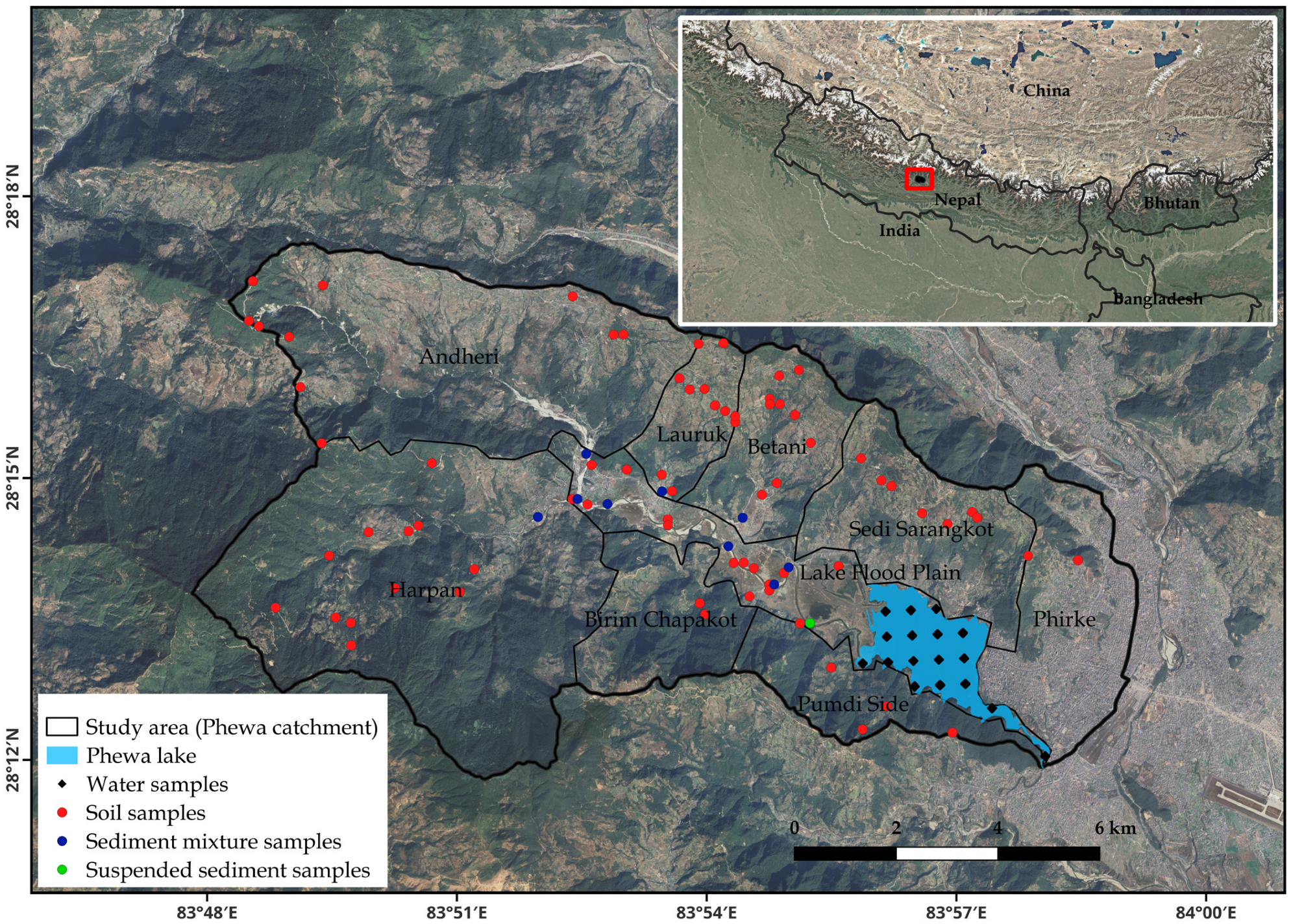
To address this gap, this study examines the impacts of land use and land cover change on nutrient dynamics and water quality in the Phewa Lake catchment. The specific objectives are to (i) assess land use and land cover (LULC) changes between 1990 and 2021 using Landsat satellite imagery processed in Google Earth Engine; (ii) estimate nutrient loading for two time periods using the Integrated Valuation of Ecosystem Services and Tradeoffs (InVEST) model; (iii) assess the spatial distribution of nitrogen and phosphorus and key soil properties through surface soil sampling, riverbed sediment collection during the dry season (2022) and suspended sediment sampling during the monsoon (2023); and (iv) evaluate water quality and the spatial distribution of eutrophication across zones of Phewa Lake.
By integrating remote sensing, ecosystem services modeling, and empirical field data, this study will provide new insights into how LULC change influences nutrient delivery and lake eutrophication. These findings will provide valuable insights for catchment management and support the design of strategies to mitigate nutrient pollution in Himalayan lake systems.
4. Discussion
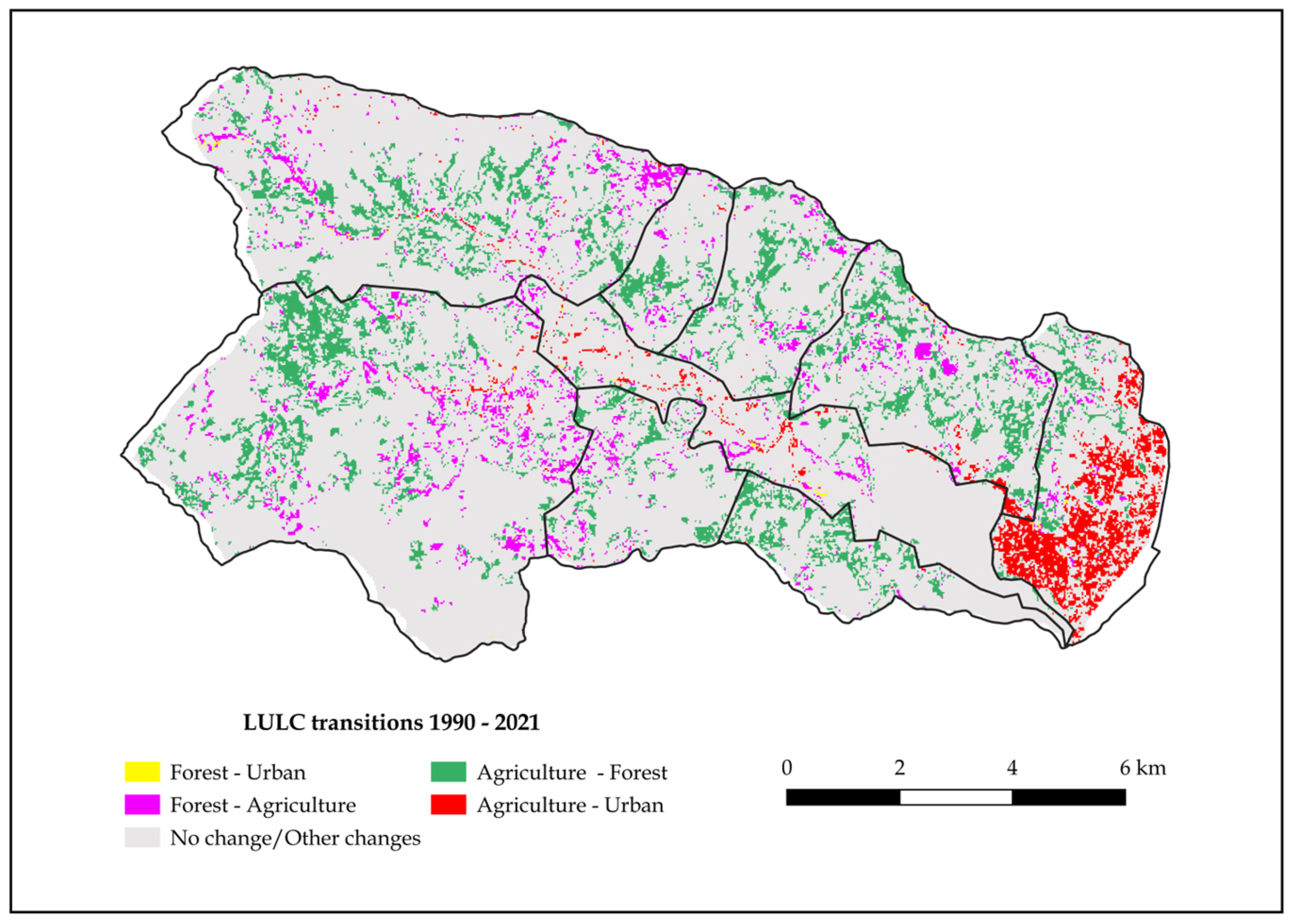
The analysis of land use/land cover (LULC) dynamics between 1990 and 2021 in the Phewa Lake catchment reveals a significant landscape transformation. The most notable trend is the decline in agricultural land and a concurrent increase in forest and built-up areas. Agricultural land, which occupied over 52% of the catchment in 1990, declined to 39% by 2021, whereas forest cover increased from 41% to nearly 50%. Built-up land tripled in the area over the 31-year period, particularly in the Phirke subcatchment and the lake’s floodplain, driven by unregulated urban expansion and infrastructure development. At the same time, significant portions of agricultural land were converted to forest in upper subcatchments such as Harpan, Andheri, and Betani, indicating the role of land abandonment, natural regeneration, and afforestation programs.
The LULC dynamics of the region are driven by complex socioecological transformation and increased forest cover, reflecting the role of conservation initiatives, policy interventions, and rural outmigration. Various studies documented LULC patterns of the catchment. The period prior to the 1990s was marked by widespread deforestation driven by the expansion of settlements and agricultural land [
37]. The regain of forests from the 1970s onward and the implementation of conservation programs, particularly Community Forestry (CF), have played a pivotal role in reversing deforestation trends [
38,
39].
Migration, remittance income, and a declining dependency on farming practices have contributed to the abandonment of agricultural land in upland areas. Furthermore, uncertainty on the climate patterns, with intense rainfall and less economic return, demotivates farmers from continuing with the traditional farming system, leading to land abandonment. This, in turn, has created favorable conditions for forest regeneration, resulting in improved forest cover in the region [
40,
41].
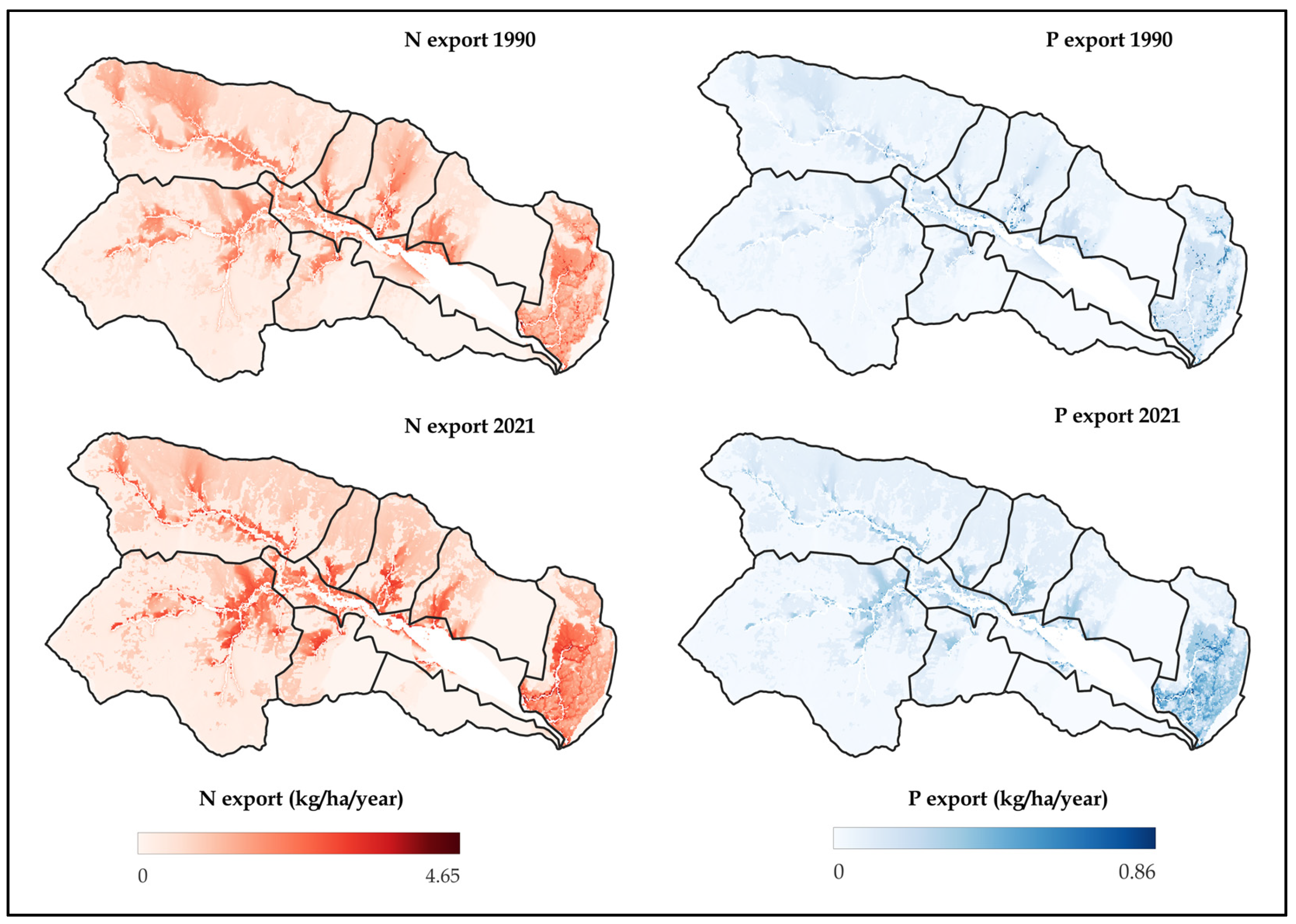
Unregulated and disorganized urban expansion, along with shifts in farming practices from subsistence, livestock-based organic farming to more commercial approaches involving increased use of chemical fertilizers and pesticide applications, have intensified nutrient loading in the lake. Nutrient exports under different land use scenarios, estimated using the NDR InVEST model, effectively demonstrate how land use change (1990 to 2021) results in eutrophication concern for the lake.
Estimated nitrogen (N) and phosphorus (P) exports using the InVEST model at subcatchments show an overall increase from 0.54 to 0.60 kg/ha/year and 0.05 to 0.065 kg/ha/year, respectively. The Phirke subcatchment recorded the highest nutrient increases, corresponding with rapid urbanization and inadequate sewage infrastructure. Conversely, Pumdi Side showed a reduction in nutrient loads, likely due to reforestation or declining human activity. These changes signal overall rising eutrophication risks, with increased nutrient inputs potentially threatening the lake’s ecological balance. Agroforestry on private lands and reforestation on public barren areas under conservation programs have also contributed to forest cover improvements and have significantly improved ecosystem services, especially nutrient retention and soil stability, through the control of erosion and enhancement of infiltration rates [
42,
43]. Further classification of agricultural land into distinct cropping systems and forest areas into specific forest types, combined with the establishment of experimental plots in representative land units, would enable more accurate estimation of nutrient retention efficiencies and thereby improve model performance.
Tributaries like Phirke Khola carry untreated municipal sewage, solid waste, and effluent from hotels into the lake [
44,
45]. Subsurface flows from septic tanks and direct discharge from sewerage pipes have contributed to the deterioration of lake water quality, with high E. coli counts and increased concentrations of nutrients and heavy metals along the urban side [
35,
36]. In contrast, dense forest cover, particularly in the southwestern catchment, acts as a natural buffer, filtering sediment and pollutants.
While improved forest cover has enhanced sediment retention capacity, the construction of hilly roads and the occurrence of large-scale landslides, often due to intense rainfall and slope failures, even within forested areas, have contributed to continued sediment exports into the lake. This underscores the need for advanced modeling approaches capable of quantifying mass movement caused by landslides, road excavations, and exposed terrain. Subcatchments like Andheri and Lauruk exhibit particularly high sediment yields due to recent road construction activities and landslides [
46]. The severity of erosion not only contributes to the siltation but also contributes to nutrient transport to the lake.
Agricultural intensification has compounded this issue. The use of chemical fertilizers (e.g., urea and DAP) and pesticides, particularly for cash crops like tomatoes and potatoes, has increased significantly [
47]. Research indicates that 50–70% of these fertilizers and most pesticides are not absorbed by crops and are instead lost to the environment via surface runoff, contributing to eutrophication of the lake [
34]. Over time, the lake has transitioned from oligotrophic conditions in the 1970s to eutrophic conditions post-1990s [
35,
44]. Furthermore, regular or seasonal monitoring of water quality parameters is essential to capture the complex influence of rainfall events and seasonal land use practices, as well as to monitor the impacts of implemented interventions.
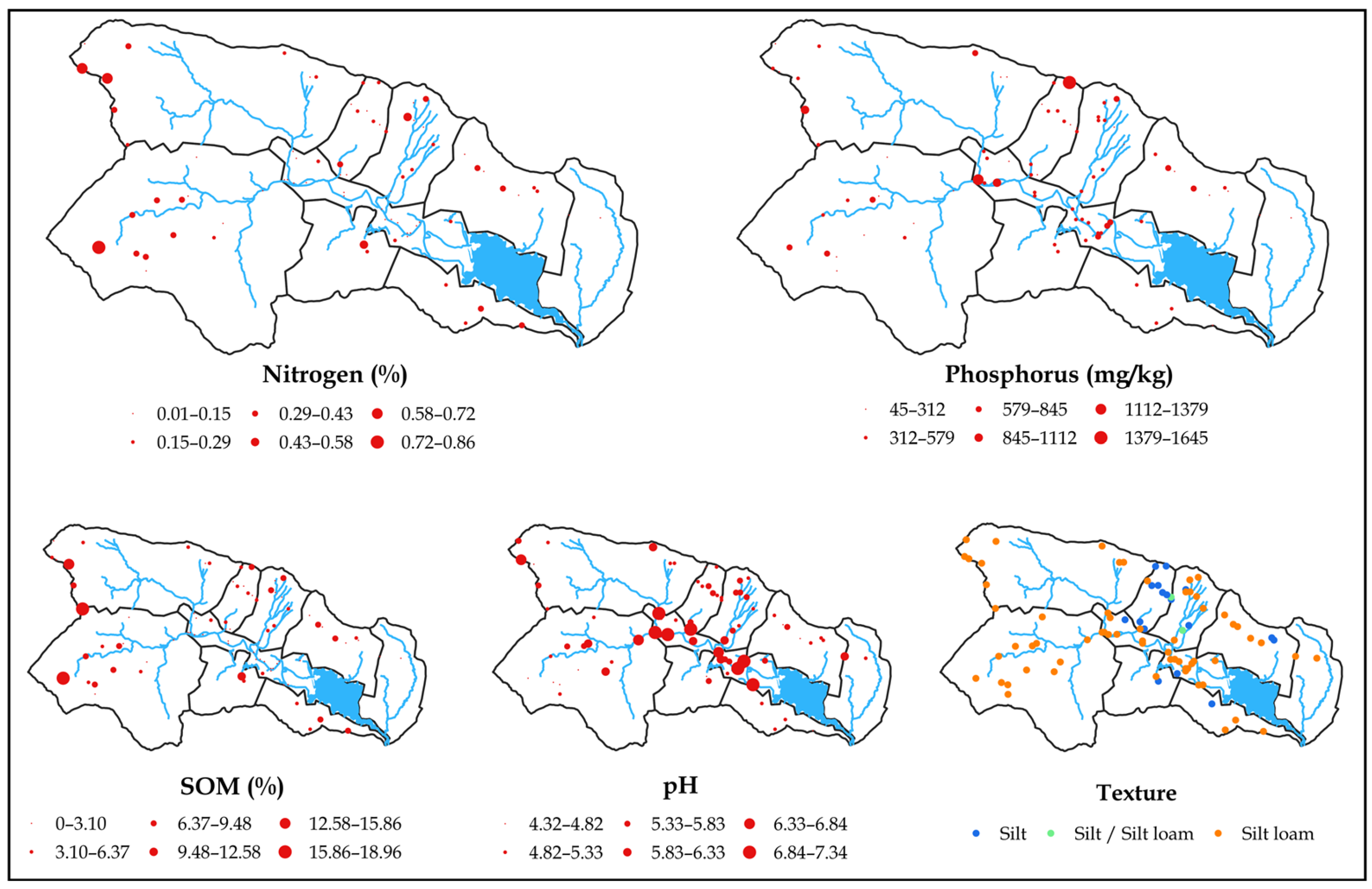
Regarding the particulate nitrogen and phosphorus, the considerable spatial variability in their distributions across the Phewa catchment reflects the influence of lithology, land use, and geomorphic features. The ANOVA results indicate that riverbanks and bare surfaces are dominated by coarser textures, which is consistent with fluvial sorting processes and surface erosion exposing coarser particles. In contrast, croplands and forests, which exhibited similar textural characteristics, showed higher silt and clay contents, supporting their role in nutrient retention due to increased surface area for nutrient adsorption, particularly for nitrogen, as confirmed by its significant positive correlation with finer fractions and SOM content.
At the subcatchment scale, significant differences in grain size distributions were evident, with the Lake Floodplain and Andheri catchment dominated by sand fractions, while Harpan and Pumdi Side, with greater forest cover, showed higher clay fraction and SOM contents. This aligns with established links between land cover, erosion processes, and sediment characteristics, as forest lands typically exhibit lower erosion rates and higher SOM accumulation, enhancing nitrogen retention. The content of nitrogen is also in line with the limited nitrogen retention capacity due to intensive cropping.
In contrast, the high variability in phosphorus content across subcatchments, especially in Lauruk, may reflect the effect of parent material. The origin of P is likely from primary P-bearing minerals in phyllites, likely bound to silicates [
48] and secondary minerals comprising pedogenetic metastable and metamorphic phosphates [
49]. Additionally, the significant relationship between P and SOM in source samples suggests they are bound to soil organic matter, possibly through organo-mineral complexes or particulate organic matter, which may contribute to the high P content observed in croplands. Furthermore, the highest P levels in riverbanks indicate that it has been mobilized with eroded soil and sediment particles that accumulate along the Harpan riverbanks in the floodplain, potentially intensified by quarry waste deposits located in the upstream floodplain. Ramos et al. (2022) [
14] also found in a Mediterranean catchment with Tertiary sand formations that croplands and riverbanks had higher P levels than forests and degraded bare surfaces.
In the riverbed and suspended sediment samples, nitrogen content showed stronger positive correlations with the finer fractions and SOM compared to the source samples, underscoring the role of organic matter and fine particles in nitrogen transport. However, phosphorus displayed a different behavior. No significant correlations were found between phosphorus content and particle size fractions, and a negative correlation with SOM was observed. This suggests that, unlike nitrogen, phosphorus transport is not driven by association with organic matter or finer particles. Considering that phyllites, the dominant lithology in the catchment, contain levels of phosphorus of around 600 ppm, it is plausible that part of the phosphorus in the sediments derives directly from mineral sources, being transported as inorganic particulate phosphorus associated with coarser mineral particles. However, the role of pedogenetic processes cannot be excluded, as weathering and soil formation under acidic conditions could mobilize phosphorus from primary minerals and redistribute it within the soil matrix, potentially contributing to the observed sediment phosphorus content.
In addition, the highest content of P in suspended sediment samples suggests high loads of P reaching the Phewa Lake during intense precipitation events. This, along with the reworking and mobilization of riverbed sediments and the erosion of riverbanks during floods, amplifies the impact of P export into Phewa Lake as found in other study areas [
16,
50]. The enrichment of phosphorus in suspended sediments suggests that particulate phosphorus is preferentially mobilized by greater flow energies associated with higher discharges, removing P-rich material transported in association with coarser mineral particles (
Figure 6), highlighting its potential for downstream eutrophication risks. In addition, under high rainfalls that mobilize high amounts of sediments, P would also be exported in its soluble form [
18].
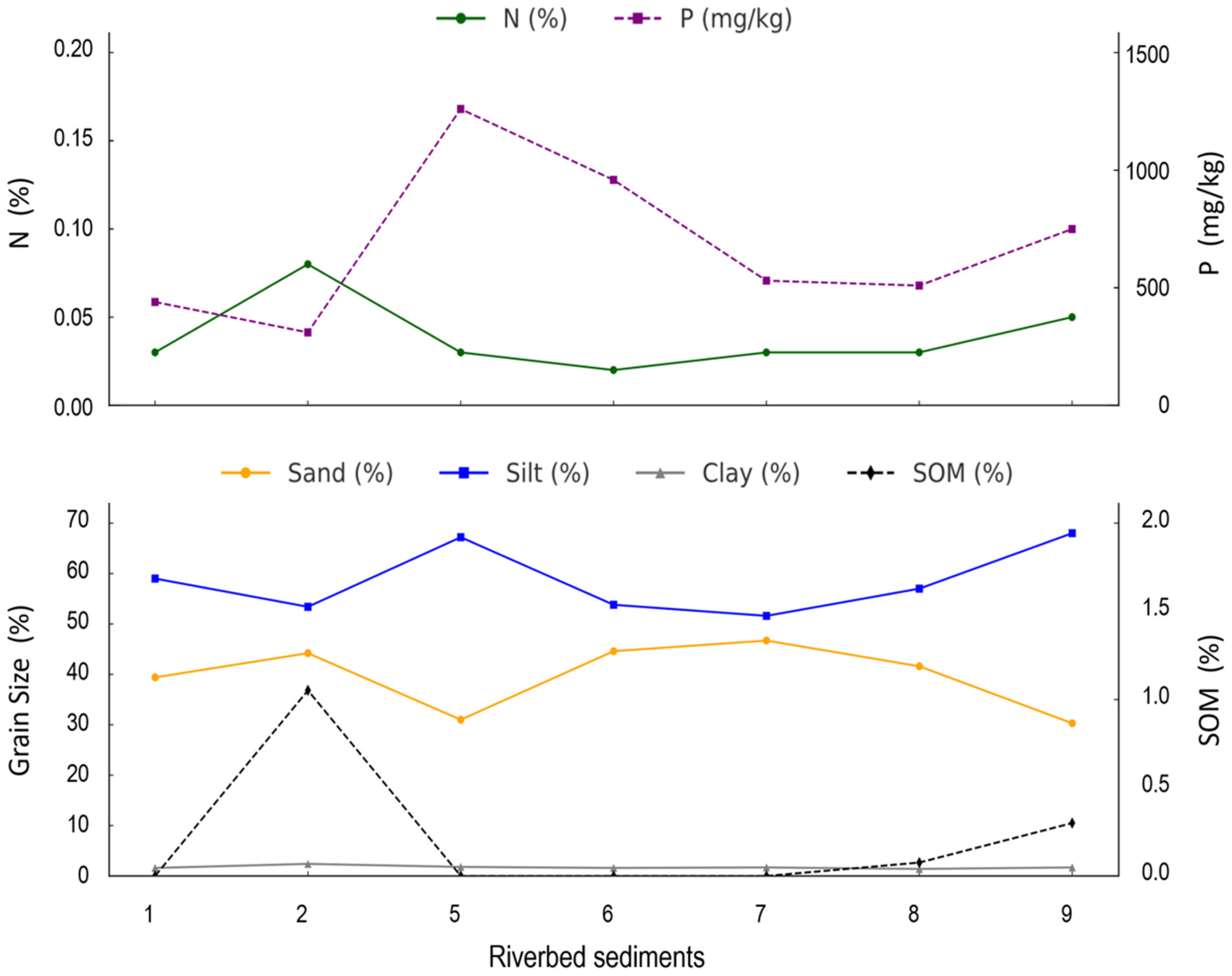
The analysis of sediments indicated depletion in N and SOM in riverbed and suspended sediments, consistent with selective transport. The longitudinal patterns along the Harpan River further illustrate these dynamics. The relatively stable clay content, alongside contrasting sand and silt distributions, with sand content peaking at confluences and outlets, reflects typical fluvial sediment sorting processes, as well as the influence of quarrying activities in the alluvial floodplain. The coinciding peaks of phosphorus with sand content at Point 5, followed by a progressive decrease and a final rise near the lake inflow, suggest episodic sediment particulate phosphorus transport linked to hydrological connectivity and sediment inputs from tributaries, similar to findings in an upland agroforestry catchment [
51]. In contrast, nitrogen showed a distinct pattern, with its highest content at the Harpan outlet (P2), likely related to the predominance of forest soils with higher nitrogen levels, followed by a downstream decrease and another increase near the lake. This may indicate localized inputs, potentially from forests as well as from increased human and livestock presence near the lake inflow. However, as dissolved nitrogen content is generally higher than particulate nitrogen [
19], total nitrogen inputs could be much greater, further exacerbating pollution in Phewa Lake.
Overall, the findings highlight a dual trajectory of reforestation and urbanization in the catchment, with both positive (forest recovery) and negative (pollution and land degradation) implications for the lake’s long-term health.
The results help to identify the key environmental and anthropogenic drivers of change. The rural-to-urban migration has promoted reforestation, yet has inadvertently led to increased nutrient discharge. If current trends continue, urban populations are likely to face growing water-related challenges in the near future unless urgent remedial measures are implemented.
Despite conservation improvements, unplanned development and pollutant inputs continue to threaten the lake’s ecological integrity. Mitigating these impacts requires integrated catchment management, enforcing land use regulations, implementing wastewater treatment, and promoting sustainable agriculture. Buffer zones, effluent pretreatment, and economic incentives for conservation (e.g., environmental taxes) could work better for restoring water quality. Regular monitoring and implementation are essential to sustain ecosystem services and safeguard Phewa Lake’s long-term health.
5. Conclusions
The degradation of Phewa Lake is strongly linked to unsustainable land use practices, including unplanned urban expansion, cultivation on steep slopes, unstable road construction, and intensified rainfall-driven erosion. This study, by integrating remote sensing, ecosystem services modeling, and empirical field data, provided new insights into how LULC change influences nutrient delivery and lake eutrophication.
This study highlights key environmental and human drivers of change across the catchment. Notably, land use transitions show a shift from agriculture to forest in upland areas, partly due to rural-to-urban migration, and into built-up areas in urbanizing lowlands. While reforestation supports sediment retention and nutrient control, it also poses challenges for local agricultural productivity. In contrast, rapid urban growth has led to increased nutrient discharge and pollution of lake water. These results underscore a dual trajectory of reforestation and urbanization, with both positive (forest recovery) and negative (pollution and land degradation) consequences for the long-term health of Phewa Lake.
Our findings show marked spatial variability in nitrogen and phosphorus. Nitrogen is strongly associated with forest soils rich in SOM and fine particles, enhancing its retention, whereas phosphorus concentrations are higher in croplands and riverbanks, largely due to mineral sources and erosion. During monsoon rainfall events, suspended sediments were enriched in phosphorus and depleted in nitrogen, indicating distinct transport mechanisms and suggesting an increased risk of eutrophication during periods of high flow.
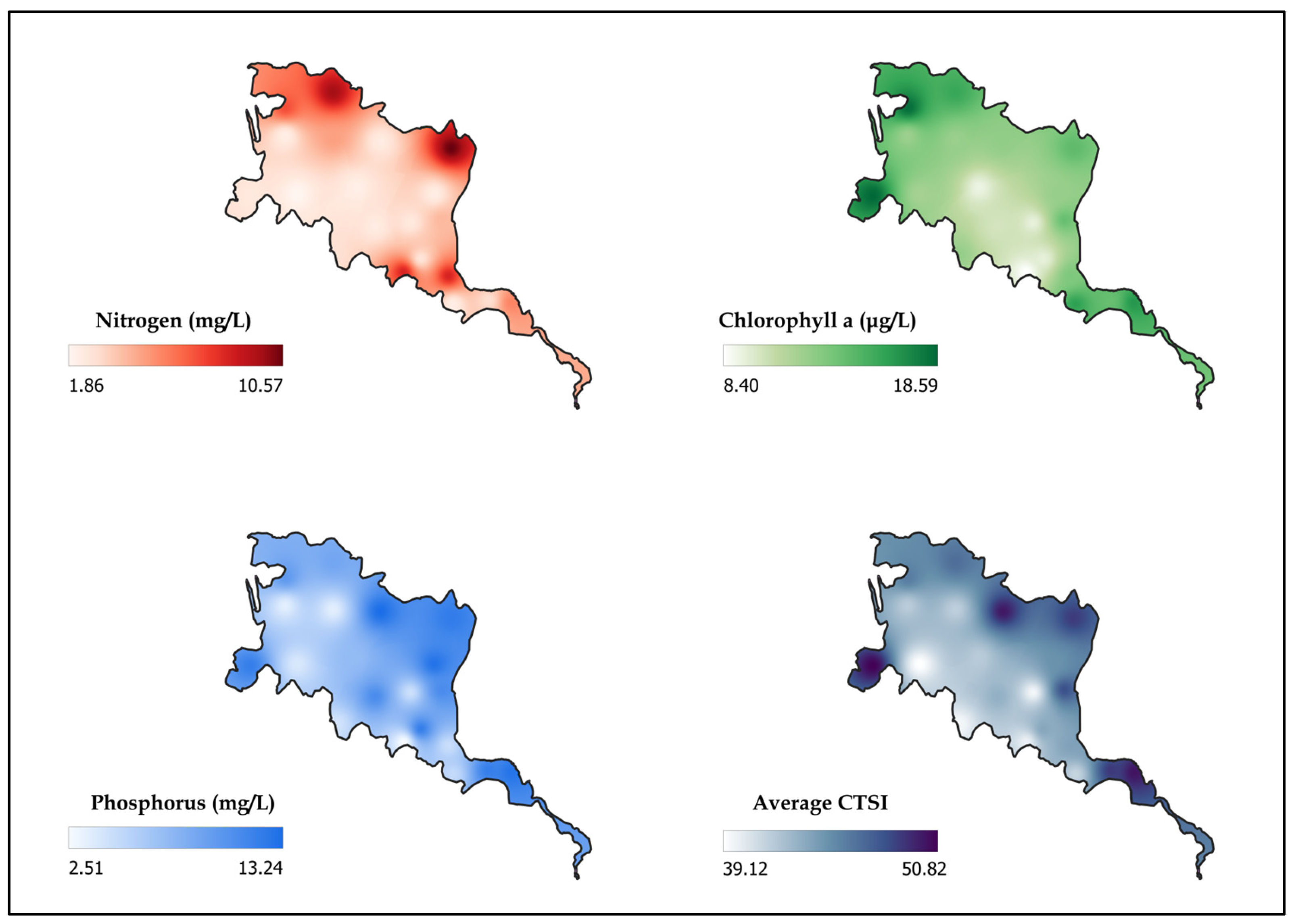
The rate of nutrient exports due to land use changes is higher in the Phirke subcatchment, which has experienced greater urbanization. This increased nutrient exports from the catchment aligns with shifts in the lake’s trophic status, as indicated by Carlson Trophic State Index values ranging from oligotrophic to eutrophic. Elevated phosphorus loading from urbanized areas, coupled with excessive use of chemical fertilizers in agriculture, along with pollution and sedimentation caused by poor waste management, improper land use, and haphazard construction activities, remains a major concern for lake conservation.
Overall, the study underscores the importance of regular water quality monitoring and integrated catchment-scale management to control pollution sources within the catchment. Recommended strategies include sustainable land use planning, targeted soil and nutrient management in agricultural headwaters, and effective urban planning and pollution control measures to mitigate nutrient exports, reduce downstream eutrophication risks, and preserve the ecological integrity and ecosystem services of Phewa Lake.
