
Applications of Machine Learning and Remote Sensing in Soil and Water Conservation

 and
and 
Abstract
1. Introduction
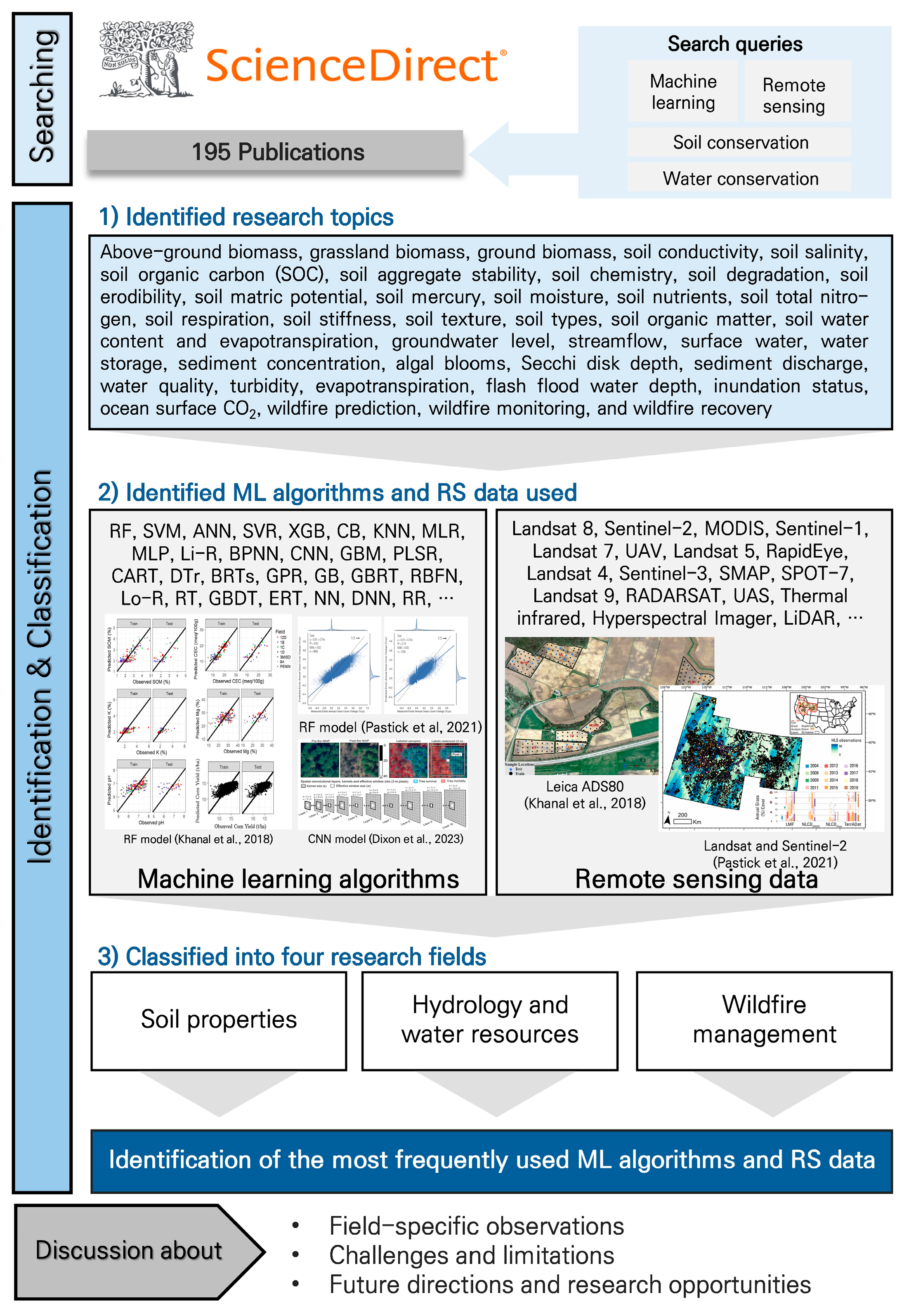
2. Materials and Methods
Searching/Classification Methodology
3. Results and Discussion
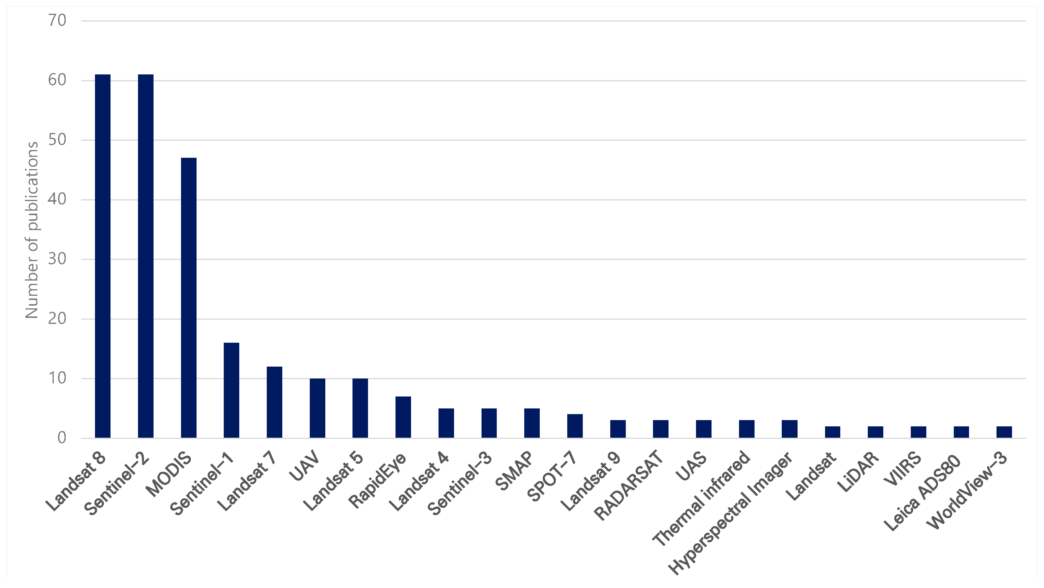
3.1. Types and Frequencies of RS Data Used in Soil and Water Conservation Research
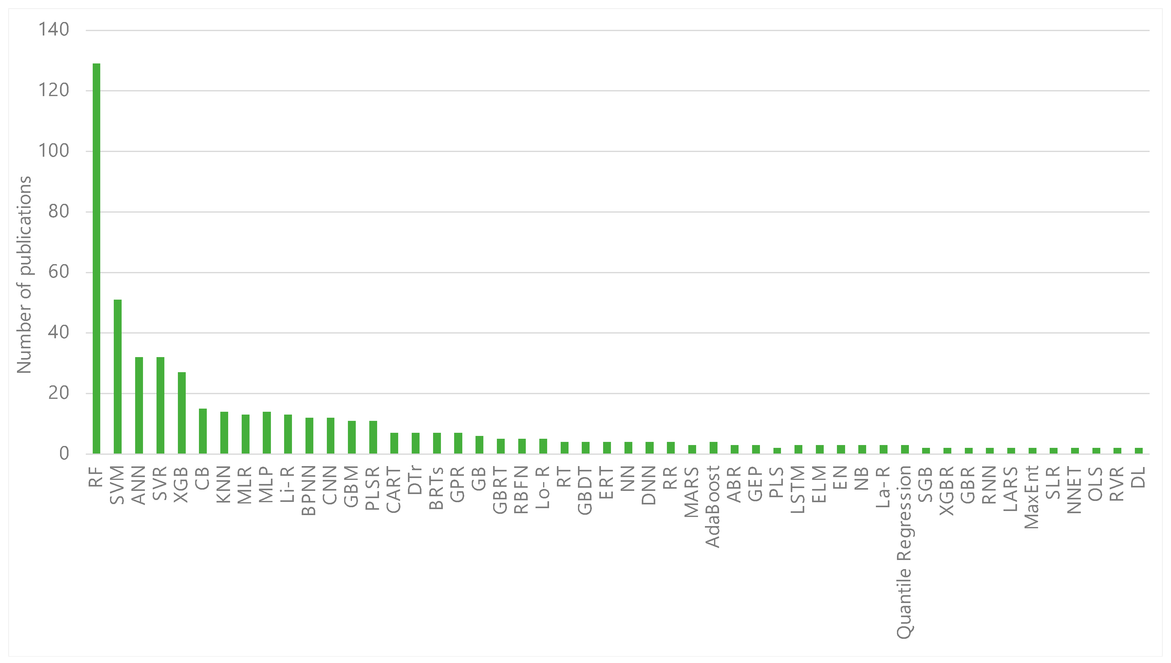
3.2. Types and Frequencies of ML Algorithm Used in Soil and Water Conservation Research
3.3. Field-Specific Observations
3.3.1. Soil Properties
3.3.2. Hydrology and Water Resources
3.3.3. Wildfire Management
4. Challenges and Limitations
4.1. Data-Related Challenges
4.2. Limitations in Technology and Implementation
5. Conclusions and Future Directions
Author Contributions
Funding
Data Availability Statement
Conflicts of Interest
Appendix A

| ML | Full Name |
|---|---|
| ABR | Adaptive Boosting Regression |
| AdaBag | Boosting and Bagging |
| AdaBoost | Boosted Classifier |
| ANFIS | Adaptive Neuro Fuzzy Inference System |
| ANN | Artificial Neural Network |
| ARD | Automatic Relevance Determination |
| BAGGING | Bootstrap Aggregating Regression |
| BAYE | Bayesian |
| B-CART | Bagged Classification and Regression Trees |
| BDT | Bagging Decision Tree |
| BPNN | Back Propagation Neural Network |
| BRTs | Boosted Regression Trees |
| BST | Extreme Gradient Boosting Tree |
| CART | Classification and Regression Trees |
| CB | Cubist |
| CBR | Catboost Regression |
| CNN | Convolutional Neural Network |
| DBN | Deep Belief Network |
| DELM | Deep Extreme Learning Machine |
| DL | Deep Learning |
| DMP | Dense Multilayer Perceptron |
| DNN | Deep Neural Networks |
| DR | Dmine Regression |
| DRF | Distributed Random Forest |
| DTr | Decision Tree |
| EBP | Error Back Propagation |
| EFS | Exhaustive Feature Selection |
| ELM | Extreme Learning Machine |
| ELR | Extreme Learning Machine Regression |
| EM | Evaluation metrics |
| EN | Elastic Net |
| EPR | Evolutionary Polynomial Regression |
| ERT | Extremely Randomized Tree |
| ETR | Extreme Tree Regression |
| FCN | Fully Connected Network |
| FNN | Feed Forward Neural Networks |
| FR | Frequency Ratio |
| GAN | Generative Adversarial Networks |
| GB | Gradient Boosting |
| GBDT | Gradient Boosted Decision Tree |
| GBM | Gradient Boosting Machine |
| GBR | Gradient Boosting Regression |
| GBRT | Gradient Boosting Regression Tree |
| GEP | Genetic Expression Programming |
| GLM | Generalized Linear Model |
| GPR | Gaussian Process Regression |
| GRNN | General Regression Neural Network |
| GSC | Generalized Synthetic Control |
| Isolation Forest | Isolation Forest |
| KNN | K-Nearest Neighbors |
| La-R | Lasso Regression |
| LARS | Least Angle Regression |
| LDA | Linear Discriminant Analysis |
| LGBM | Light Gradient Boosting Machine |
| Li-R | Linear Regression |
| LMM | Linear Mixed-Effects Model |
| Lo-R | Logistic Regression |
| LSTM | Long Short-Term Memory |
| M5P | M5-Pruned |
| MARS | Multivariate Adaptive Regression Spline |
| MaxEnt | Maximum Entropy Model |
| MDN | Mixture Density Network |
| MLP | Multilayer Perceptron |
| MLPR | Multilayer Perceptron Regression |
| MLR | Multiple Linear Regression |
| MR-CNN | Mask Region-Based Convolutional Neural Network |
| MT | M5 Model Tree |
| NB | Naïve Bayes |
| Neu-SICR | Neural Network-Satellite and in situ Sensor Collaborated Reconstruction |
| NN | Neural Networks |
| NNET | Feed-Forward Neural Network |
| OLS | Ordinary Least Squares |
| PCR | Principal Component Regression |
| PKR | Polynomial Kernel Regression |
| PLS | Partial Least Squares |
| PLSR | Partial Least Squares Regression |
| PSO-SVR | Particle Swarm Optimization and Support Vector Machine |
| QR | Quantile Regression Forest |
| RBFN | Radial Basin Function Neural Network |
| RF | Random Forest |
| RNN | Recurrent Neural Network |
| RPART | Recursive Partitioning and Regression Trees |
| RR | Ridge Regression |
| RT | Regression Tree |
| RTM | Radiative Transfer Models |
| RVR | Relevance Vector Regression |
| SA | Sensitivity Analysis |
| SCA-Elman | Sine Cosine Algorithm-Elman |
| SGB | Stochastic Gradient Boosting |
| SICR | Sensor Collaborated Reconstruction |
| SLR | Stepwise Linear Regression |
| SoLIM | Soil–Landscape Inference Model (Fuzzy Logic) |
| SOM | Self-Organizing Maps |
| SR | Simple Regression |
| SVM | Support Vector Machine |
| SVR | Support Vector Regression |
| XGB | EXtreme Gradient Boosting |
| XGBR | EXtreme Gradient Boosting Regression |
| YOLO | You Only Look Once |
| RS Techniques | Descriptions | |
|---|---|---|
| Satellite | ALOS-2 * |
|
| Chinese Environmental 1A |
| |
| GF-1 |
| |
| GOES-16 |
| |
| Himawari-8 |
| |
| Landsat 4, 5 |
| |
| Landsat 7 |
| |
| Landsat 8, 9 |
| |
| RADARSAT |
| |
| RapidEye |
| |
| Sentinel-1 |
| |
| Sentinel-2 |
| |
| Sentinel-3 |
| |
| SMAP |
| |
| SPOT-4 |
| |
| SPOT-7 |
| |
| SRTM |
| |
| Terra |
| |
| Triplesat |
| |
| WorldView-3 |
| |
| ZH-1 |
| |
| AGRS |
| |
| AMSR-E |
| |
| AVIRIS-NG |
| |
| ETM+ |
| |
| Thermal infrared |
| |
| Leica ADS80 |
| |
| LiDAR |
| |
| MERIS |
| |
| MODIS |
| |
| PALSAR-2 |
| |
| SAR |
| |
| SVC |
| |
| TDC |
| |
| Hyperspectral Imager |
| |
| TM |
| |
| UAS/UAV |
| |
| VIIRS |
| |
References
- Pereira, P.; Bogunovic, I.; Muñoz-Rojas, M.; Brevik, E.C. Soil ecosystem services, sustainability, valuation and management. Curr. Opin. Environ. Sci. Health 2018, 5, 7–13. [Google Scholar] [CrossRef]
- Trap, J.; Bonkowski, M.; Plassard, C.; Villenave, C.; Blanchart, E. Ecological importance of soil bacterivores for ecosystem functions. Plant Soil 2016, 398, 1–24. [Google Scholar] [CrossRef]
- Whitford, W.G. The importance of the biodiversity of soil biota in arid ecosystems. Biodivers. Conserv. 1996, 5, 185–195. [Google Scholar] [CrossRef]
- Allan, R.P.; Barlow, M.; Byrne, M.P.; Cherchi, A.; Douville, H.; Fowler, H.J.; Gan, T.Y.; Pendergrass, A.G.; Rosenfel, D.; Swann, A.; et al. Advances in understanding large-scale responses of the water cycle to climate change. Ann. N. Y. Acad. Sci. 2020, 1472, 49–75. [Google Scholar] [CrossRef]
- Peixoto, J.P.; Kettani, M.A. The control of the water cycle. Sci. Am. 1973, 228, 46–63. [Google Scholar] [CrossRef]
- Lal, R. Soil conservation and ecosystem services. Int. Soil Water Conserv. Res. 2014, 2, 36–47. [Google Scholar] [CrossRef]
- Neary, D.G.; Ryan, K.C.; DeBano, L.F. Wildland fire in ecosystems: Effects of fire on soils and water. Gen. Tech. Rep. 2005, 4, 42. [Google Scholar]
- Ali, M.; Talukder, M. Increasing water productivity in crop production—A synthesis. Agric. Water Manag. 2008, 95, 1201–1213. [Google Scholar] [CrossRef]
- Akhtar, N.; Syakir Ishak, M.I.; Bhawani, S.A.; Umar, K. Various natural and anthropogenic factors responsible for water quality degradation: A review. Water 2021, 13, 2660. [Google Scholar] [CrossRef]
- Bungau, S.; Behl, T.; Aleya, L.; Bourgeade, P.; Aloui-Sossé, B.; Purza, A.L.; Abid, A.; Samuel, A.D. Expatiating the impact of anthropogenic aspects and climatic factors on long-term soil monitoring and management. Environ. Sci. Pollut. Res. 2021, 28, 30528–30550. [Google Scholar] [CrossRef]
- Zhang, X.; Chen, J.; Tan, M.; Sun, Y. Assessing the impact of urban sprawl on soil resources of Nanjing city using satellite images and digital soil databases. Catena 2007, 69, 16–30. [Google Scholar] [CrossRef]
- Hajabbasi, M.A.; Jalalian, A.; Karimzadeh, H.R. Deforestation effects on soil physical and chemical properties, Lordegan, Iran. Plant Soil 1997, 190, 301–308. [Google Scholar] [CrossRef]
- Syamsih, D. Impacts of Deforestation on Soil Quality and Water Resources in Tropical Forest Areas of Sumatra. J. Horiz. 2024, 1, 16–22. [Google Scholar] [CrossRef]
- Blanco-Canqui, H.; Lal, R. Soil and water conservation. In Principles of Soil Conservation and Management, 1st ed.; Springer: Dordrecht, The Netherlands, 2008; pp. 1–19. [Google Scholar]
- Côté, I.M.; Darling, E.S.; Brown, C.J. Interactions among ecosystem stressors and their importance in conservation. Proc. R. Soc. B Biol. Sci. 2016, 283, 20152592. [Google Scholar] [CrossRef]
- Gassman, P.W.; Reyes, M.R.; Green, C.H.; Arnold, J. The soil and water assessment tool: Historical development, applications, and future research directions. Trans. ASABE 2007, 50, 1211–1250. [Google Scholar] [CrossRef]
- Mansell, R.S.; Ma, L.; Ahuja, L.R.; Bloom, S.A. Adaptive grid refinement in numerical models for water flow and chemical transport in soil: A review. Vadose Zone J. 2002, 1, 222–238. [Google Scholar] [CrossRef]
- Kattenberg, A.; Giorgi, F.; Grassl, H.; Meehl, G.A.; Mitchell, J.F.B.; Stouffer, R.J.; Tokioka, T.; Weaver, A.J.; Wigley, T.M.L. Climate models–projections of future climate. In Climate Change 1995, The Science of Climate Change: Contribution of Working Group I to the Second Assessment Report of the Intergovernmental Panel on Climate Change; Houghton, J.T., Meira Filbo, B.G., Callander, B.A., Harris, N., Kattenberg, A., Maskell, K., Eds.; Cambridge University Press: Cambridge, UK, 1996; pp. 285–357. [Google Scholar]
- Kavetski, D.; Franks, S.W.; Kuczera, G. Confronting input uncertainty in environmental modelling. Calibration Watershed Models 2003, 6, 49–68. [Google Scholar]
- Matott, L.S.; Babendreier, J.E.; Purucker, S.T. Evaluating uncertainty in integrated environmental models: A review of concepts and tools. Water Resour. Res. 2009, 45. [Google Scholar] [CrossRef]
- Refsgaard, J.C.; van der Sluijs, J.P.; Højberg, A.L.; Vanrolleghem, P.A. Uncertainty in the environmental modelling process—A framework and guidance. Environ. Model. Softw. 2007, 22, 1543–1556. [Google Scholar] [CrossRef]
- Zhong, S.; Zhang, K.; Bagheri, M.; Burken, J.G.; Gu, A.; Li, B.; Ma, X.; Marrone, B.L.; Ren, Z.J.; Schrier, J.; et al. Machine learning: New ideas and tools in environmental science and engineering. Environ. Sci. Technol. 2021, 55, 12741–12754. [Google Scholar] [CrossRef]
- Huang, C.; Chen, Y.; Zhang, S.; Wu, J. Detecting, extracting, and monitoring surface water from space using optical sensors: A review. Rev. Geophys. 2018, 56, 333–360. [Google Scholar] [CrossRef]
- Rogan, J.; Chen, D. Remote sensing technology for mapping and monitoring land-cover and land-use change. Prog. Plan. 2004, 61, 301–325. [Google Scholar] [CrossRef]
- Florath, J.; Keller, S. Supervised machine learning approaches on multispectral remote sensing data for a combined detection of fire and burned area. Remote Sens. 2022, 14, 657. [Google Scholar] [CrossRef]
- Sun, A.Y.; Scanlon, B.R. How can Big Data and machine learning benefit environment and water management: A survey of methods, applications, and future directions. Environ. Res. Lett. 2019, 14, 073001. [Google Scholar] [CrossRef]
- Glasgow, H.B.; Burkholder, J.M.; Reed, R.E.; Lewitus, A.J.; Kleinman, J.E. Real-time remote monitoring of water quality: A review of current applications, and advancements in sensor, telemetry, and computing technologies. J. Exp. Mar. Biol. Ecol. 2004, 300, 409–448. [Google Scholar] [CrossRef]
- Wang, S.; Guan, K.; Zhang, C.; Lee, D.; Margenot, A.J.; Ge, Y.; Peng, J.; Zhou, W.; Zhou, Q.; Huang, Y. Using soil library hyperspectral reflectance and machine learning to predict soil organic carbon: Assessing potential of airborne and spaceborne optical soil sensing. Remote Sens. Environ. 2022, 271, 112914. [Google Scholar] [CrossRef]
- Detsikas, S.E.; Petropoulos, G.P.; Kalogeropoulos, K.; Faraslis, I. Combining Low-Cost UAV Imagery with Machine Learning Classifiers for Accurate Land Use/Land Cover Mapping. Earth 2024, 5, 244–254. [Google Scholar] [CrossRef]
- Zhang, Y.; Liu, J.; Shen, W. A review of ensemble learning algorithms used in remote sensing applications. Appl. Sci. 2022, 12, 8654. [Google Scholar] [CrossRef]
- Khanal, S.; Fulton, J.; Klopfenstein, A.; Douridas, N.; Shearer, S. Integration of high resolution remotely sensed data and machine learning techniques for spatial prediction of soil properties and corn yield. Comput. Electron. Agric. 2018, 153, 213–225. [Google Scholar] [CrossRef]
- Dixon, D.J.; Zhu, Y.; Brown, C.F.; Jin, Y. Satellite detection of canopy-scale tree mortality and survival from California wildfires with spatio-temporal deep learning. Remote Sens. Environ. 2023, 298, 113842. [Google Scholar] [CrossRef]
- Pastick, N.J.; Wylie, B.K.; Rigge, M.B.; Dahal, D.; Boyte, S.P.; Jones, M.O.; Allredm, B.W.; Parajuli, S.; Wu, Z. Rapid monitoring of the abundance and spread of exotic annual grasses in the western United States using remote sensing and machine learning. AGU Adv. 2021, 2, e2020AV000298. [Google Scholar] [CrossRef]
- Saygın, F.; Aksoy, H.; Alaboz, P.; Dengiz, O. Different approaches to estimating soil properties for digital soil map integrated with machine learning and remote sensing techniques in a sub-humid ecosystem. Environ. Monit. Assess. 2023, 195, 1061. [Google Scholar] [CrossRef] [PubMed]
- Rezaei, M.; Mousavi, S.R.; Rahmani, A.; Zeraatpisheh, M.; Rahmati, M.; Pakparvar, M.; Mahjenabadi, V.A.J.; Seuntjens, P.; Cornelis, W. Incorporating machine learning models and remote sensing to assess the spatial distribution of saturated hydraulic conductivity in a light-textured soil. Comput. Electron. Agric. 2023, 209, 107821. [Google Scholar] [CrossRef]
- Jia, P.; Zhang, J.; He, W.; Hu, Y.; Zeng, R.; Zamanian, K.; Jia, K.; Zhao, X. Combination of hyperspectral and machine learning to invert soil electrical conductivity. Remote Sens. 2022, 14, 2602. [Google Scholar] [CrossRef]
- Wang, N.; Xue, J.; Peng, J.; Biswas, A.; He, Y.; Shi, Z. Integrating remote sensing and landscape characteristics to estimate soil salinity using machine learning methods: A case study from Southern Xinjiang, China. Remote Sens. 2020, 12, 4118. [Google Scholar] [CrossRef]
- Mohamed, S.A.; Metwaly, M.M.; Metwalli, M.R.; AbdelRahman, M.A.; Badreldin, N. Integrating active and passive remote sensing data for mapping soil salinity using machine learning and feature selection approaches in arid regions. Remote Sens. 2023, 15, 1751. [Google Scholar] [CrossRef]
- Wang, Z.; Zhang, F.; Zhang, X.; Chan, N.W.; Ariken, M.; Zhou, X.; Wang, Y. Regional suitability prediction of soil salinization based on remote-sensing derivatives and optimal spectral index. Sci. Total Environ. 2021, 775, 145807. [Google Scholar] [CrossRef] [PubMed]
- Cui, J.; Chen, X.; Han, W.; Cui, X.; Ma, W.; Li, G. Estimation of soil salt content at different depths using UAV multi-spectral remote sensing combined with machine learning algorithms. Remote Sens. 2023, 15, 5254. [Google Scholar] [CrossRef]
- Naimi, S.; Ayoubi, S.; Zeraatpisheh, M.; Dematte, J.A.M. Ground observations and environmental covariates integration for mapping of soil salinity: A machine learning-based approach. Remote Sens. 2021, 13, 4825. [Google Scholar] [CrossRef]
- Wang, S.; Chen, Y.; Wang, M.; Li, J. Performance comparison of machine learning algorithms for estimating the soil salinity of salt-affected soil using field spectral data. Remote Sens. 2019, 11, 2605. [Google Scholar] [CrossRef]
- Erkin, N.; Zhu, L.; Gu, H.; Tusiyiti, A. Method for predicting soil salinity concentrations in croplands based on machine learning and remote sensing techniques. J. Appl. Remote Sens. 2019, 13, 034520. [Google Scholar] [CrossRef]
- Kaplan, G.; Gašparović, M.; Alqasemi, A.S.; Aldhaheri, A.; Abuelgasim, A.; Ibrahim, M. Soil salinity prediction using Machine Learning and Sentinel–2 Remote Sensing Data in Hyper–Arid areas. Phys. Chem. Earth Parts A/B/C 2023, 130, 103400. [Google Scholar] [CrossRef]
- Jiang, X.; Duan, H.; Liao, J.; Guo, P.; Huang, C.; Xue, X. Estimation of soil salinization by machine learning algorithms in different arid regions of northwest China. Remote Sens. 2022, 14, 347. [Google Scholar] [CrossRef]
- Haq, Y.U.; Shahbaz, M.; Asif, H.S.; Al-Laith, A.; Alsabban, W.H. Spatial mapping of soil salinity using machine learning and remote sensing in Kot Addu, Pakistan. Sustainability 2023, 15, 12943. [Google Scholar] [CrossRef]
- Wang, J.; Ding, J.; Yu, D.; Teng, D.; He, B.; Chen, X.; Ge, X.; Zhang, Z.; Wang, Y.; Yang, W.; et al. Machine learning-based detection of soil salinity in an arid desert region, Northwest China: A comparison between Landsat-8 OLI and Sentinel-2 MSI. Sci. Total Environ. 2020, 707, 136092. [Google Scholar] [CrossRef]
- Zhang, H.; Fu, X.; Zhang, Y.; Qi, Z.; Zhang, H.; Xu, Z. Mapping Multi-Depth Soil Salinity Using Remote Sensing-Enabled Machine Learning in the Yellow River Delta, China. Remote Sens. 2023, 15, 5640. [Google Scholar] [CrossRef]
- Wei, Q.; Nurmemet, I.; Gao, M.; Xie, B. Inversion of soil salinity using multisource remote sensing data and particle swarm machine learning models in Keriya Oasis, northwestern China. Remote Sens. 2022, 14, 512. [Google Scholar] [CrossRef]
- Hoa, P.V.; Giang, N.V.; Binh, N.A.; Hai, L.V.H.; Pham, T.D.; Hasanlou, M.; Tien Bui, D. Soil salinity mapping using SAR sentinel-1 data and advanced machine learning algorithms: A case study at Ben Tre Province of the Mekong River Delta (Vietnam). Remote Sens. 2019, 11, 128. [Google Scholar] [CrossRef]
- Das, A.; Bhattacharya, B.K.; Setia, R.; Jayasree, G.; Das, B.S. A novel method for detecting soil salinity using AVIRIS-NG imaging spectroscopy and ensemble machine learning. ISPRS J. Photogramm. Remote Sens. 2023, 200, 191–212. [Google Scholar] [CrossRef]
- Nguyen, H.D.; Van, C.P.; Nguyen, T.G.; Dang, D.K.; Pham, T.T.N.; Nguyen, Q.H.; Bui, Q.T. Soil salinity prediction using hybrid machine learning and remote sensing in Ben Tre province on Vietnam’s Mekong River Delta. Environ. Sci. Pollut. Res. 2023, 30, 74340–74357. [Google Scholar] [CrossRef]
- Zhao, W.; Zhou, C.; Zhou, C.; Ma, H.; Wang, Z. Soil salinity inversion model of oasis in arid area based on UAV multispectral remote sensing. Remote Sens. 2022, 14, 1804. [Google Scholar] [CrossRef]
- Aksoy, S.; Yildirim, A.; Gorji, T.; Hamzehpour, N.; Tanik, A.; Sertel, E. Assessing the performance of machine learning algorithms for soil salinity mapping in Google Earth Engine platform using Sentinel-2A and Landsat-8 OLI data. Adv. Space Res. 2022, 69, 1072–1086. [Google Scholar] [CrossRef]
- Ma, G.; Ding, J.; Han, L.; Zhang, Z.; Ran, S. Digital mapping of soil salinization based on Sentinel-1 and Sentinel-2 data combined with machine learning algorithms. Reg. Sustain. 2021, 2, 177–188. [Google Scholar] [CrossRef]
- Kalambukattu, J.G.; Johns, B.; Kumar, S.; Raj, A.D.; Ellur, R. Temporal remote sensing based soil salinity mapping in Indo-Gangetic plain employing machine-learning techniques. Proc. Indian Natl. Sci. Acad. 2023, 89, 290–305. [Google Scholar] [CrossRef]
- Zhang, T.; Li, Y.; Wang, M. Remote sensing-based prediction of organic carbon in agricultural and natural soils influenced by salt and sand mining using machine learning. J. Environ. Manag. 2024, 352, 120107. [Google Scholar] [CrossRef]
- Odebiri, O.; Mutanga, O.; Odindi, J.; Naicker, R. Modelling soil organic carbon stock distribution across different land-uses in South Africa: A remote sensing and deep learning approach. ISPRS J. Photogramm. Remote Sens. 2022, 188, 351–362. [Google Scholar] [CrossRef]
- Zhang, X.; Xue, J.; Chen, S.; Wang, N.; Shi, Z.; Huang, Y.; Zhuo, Z. Digital mapping of soil organic carbon with machine learning in dryland of Northeast and North plain China. Remote Sens. 2022, 14, 2504. [Google Scholar] [CrossRef]
- Emadi, M.; Taghizadeh-Mehrjardi, R.; Cherati, A.; Danesh, M.; Mosavi, A.; Scholten, T. Predicting and mapping of soil organic carbon using machine learning algorithms in Northern Iran. Remote Sens. 2020, 12, 2234. [Google Scholar] [CrossRef]
- John, K.; Abraham, I.I.; Kebonye, N.M.; Ayito, E.O.; Agyeman, C.P.; Afu, S.M. Using machine learning algorithms to estimate soil organic carbon variability with environmental variables and soil nutrient indicators in an alluvial soil. Land 2020, 9, 487. [Google Scholar] [CrossRef]
- Meng, X.; Bao, Y.; Wang, Y.; Zhang, X.; Liu, H. An advanced soil organic carbon content prediction model via fused temporal-spatial-spectral (TSS) information based on machine learning and deep learning algorithms. Remote Sens. Environ. 2022, 280, 113166. [Google Scholar] [CrossRef]
- Zeraatpisheh, M.; Ayoubi, S.; Jafari, A.; Tajik, S.; Finke, P. Digital mapping of soil properties using multiple machine learning in a semi-arid region, central Iran. Geoderma 2019, 338, 445–452. [Google Scholar] [CrossRef]
- Zhou, T.; Geng, Y.; Chen, J.; Pan, J.; Haase, D.; Lausch, A. High-resolution digital mapping of soil organic carbon and soil total nitrogen using DEM derivatives, Sentinel-1 and Sentinel-2 data based on machine learning algorithms. Sci. Total Environ. 2020, 729, 138244. [Google Scholar] [CrossRef] [PubMed]
- Zhou, T.; Geng, Y.; Ji, C.; Xu, X.; Wang, H.; Pan, J.; Lausch, A. Prediction of soil organic carbon and the C:N ratio on a national scale using machine learning and satellite data: A comparison between Sentinel-2, Sentinel-3 and Landsat-8 images. Sci. Total Environ. 2021, 755, 142661. [Google Scholar] [CrossRef] [PubMed]
- Abdoli, P.; Khanmirzaei, A.; Hamzeh, S.; Rezaei, S.; Moghimi, S. Use of remote sensing data to predict soil organic carbon in some agricultural soils of Iran. Remote Sens. Appl. Soc. Environ. 2023, 30, 100969. [Google Scholar] [CrossRef]
- Paul, S.S.; Coops, N.C.; Johnson, M.S.; Krzic, M.; Chandna, A.; Smukler, S.M. Mapping soil organic carbon and clay using remote sensing to predict soil workability for enhanced climate change adaptation. Geoderma 2020, 363, 114177. [Google Scholar] [CrossRef]
- Hamzehpour, N.; Shafizadeh-Moghadam, H.; Valavi, R. Exploring the driving forces and digital mapping of soil organic carbon using remote sensing and soil texture. Catena 2019, 182, 104141. [Google Scholar] [CrossRef]
- Matinfar, H.R.; Maghsodi, Z.; Mousavi, S.R.; Rahmani, A. Evaluation and Prediction of Topsoil organic carbon using Machine learning and hybrid models at a Field-scale. Catena 2021, 202, 105258. [Google Scholar] [CrossRef]
- Xie, B.; Ding, J.; Ge, X.; Li, X.; Han, L.; Wang, Z. Estimation of soil organic carbon content in the Ebinur Lake wetland, Xinjiang, China, based on multisource remote sensing data and ensemble learning algorithms. Sensors 2022, 22, 2685. [Google Scholar] [CrossRef]
- Wang, B.; Waters, C.; Orgill, S.; Gray, J.; Cowie, A.; Clark, A.; Liu, L.D. High resolution mapping of soil organic carbon stocks using remote sensing variables in the semi-arid rangelands of eastern Australia. Sci. Total Environ. 2018, 630, 367–378. [Google Scholar] [CrossRef]
- Xing, C.; Chen, N.; Zhang, X.; Gong, J. A machine learning based reconstruction method for satellite remote sensing of soil moisture images with in situ observations. Remote Sens. 2017, 9, 484. [Google Scholar] [CrossRef]
- Zeraatpisheh, M.; Ayoubi, S.; Mirbagheri, Z.; Mosaddeghi, M.R.; Xu, M. Spatial prediction of soil aggregate stability and soil organic carbon in aggregate fractions using machine learning algorithms and environmental variables. Geoderma Reg. 2021, 27, e00440. [Google Scholar] [CrossRef]
- Mahjenabadi, V.A.J.; Mousavi, S.R.; Rahmani, A.; Karami, A.; Rahmani, H.A.; Khavazi, K.; Rezaei, M. Digital mapping of soil biological properties and wheat yield using remotely sensed, soil chemical data and machine learning approaches. Comput. Electron. Agric. 2022, 197, 106978. [Google Scholar] [CrossRef]
- Rukhovich, D.I.; Koroleva, P.V.; Rukhovich, D.D.; Rukhovich, A.D. Recognition of the bare soil using deep machine learning methods to create maps of arable soil degradation based on the analysis of multi-temporal remote sensing data. Remote Sens. 2022, 14, 2224. [Google Scholar] [CrossRef]
- Alexakis, D.D.; Tapoglou, E.; Vozinaki, A.E.K.; Tsanis, I.K. Integrated use of satellite remote sensing, artificial neural networks, field spectroscopy, and GIS in estimating crucial soil parameters in terms of soil erosion. Remote Sens. 2019, 11, 1106. [Google Scholar] [CrossRef]
- Fernández, D.; Adermann, E.; Pizzolato, M.; Pechenkin, R.; Rodríguez, C.G.; Taravat, A. Comparative analysis of machine learning algorithms for soil erosion modelling based on remotely sensed data. Remote Sens. 2023, 15, 482. [Google Scholar] [CrossRef]
- Do, T.A.T.; Tran, H.D.; Do, A.N.T. Classifying forest cover and mapping forest fire susceptibility in Dak Nong province, Vietnam utilizing remote sensing and machine learning. Ecol. Inform. 2024, 79, 102392. [Google Scholar]
- Saygın, F.; Aksoy, H.; Alaboz, P.; Birol, M.; Dengiz, O. Estimation of soil erodability parameters based on different machine algorithms integrated with remote sensing techniques. Int. J. Environ. Sci. Technol. 2024, 12, 9527–9540. [Google Scholar] [CrossRef]
- Maia, R.F.; Lurbe, C.B.; Hornbuckle, J. Machine learning approach to estimate soil matric potential in the plant root zone based on remote sensing data. Front. Plant Sci. 2022, 13, 931491. [Google Scholar] [CrossRef]
- Suleymanov, A.; Suleymanov, R.; Kulagin, A.; Yurkevich, M. Mercury Prediction in Urban Soils by Remote Sensing and Relief Data Using Machine Learning Techniques. Remote Sens. 2023, 15, 3158. [Google Scholar] [CrossRef]
- Senanayake, I.P.; Yeo, I.Y.; Walker, J.P.; Willgoose, G.R. Estimating catchment scale soil moisture at a high spatial resolution: Integrating remote sensing and machine learning. Sci. Total Environ. 2021, 776, 145924. [Google Scholar] [CrossRef]
- Mao, T.; Shangguan, W.; Li, Q.; Li, L.; Zhang, Y.; Huang, F.; Li, J.; Liu, W.; Zhang, R. A spatial downscaling method for remote sensing soil moisture based on random forest considering soil moisture memory and mass conservation. Remote Sens. 2022, 14, 3858. [Google Scholar] [CrossRef]
- Babaeian, E.; Paheding, S.; Siddique, N.; Devabhaktuni, V.K.; Tuller, M. Estimation of root zone soil moisture from ground and remotely sensed soil information with multisensor data fusion and automated machine learning. Remote Sens. Environ. 2021, 260, 112434. [Google Scholar] [CrossRef]
- Sun, H.; Cui, Y. Evaluating downscaling factors of microwave satellite soil moisture based on machine learning method. Remote Sens. 2021, 13, 133. [Google Scholar] [CrossRef]
- Senyurek, V.; Lei, F.; Boyd, D.; Kurum, M.; Gurbuz, A.C.; Moorhead, R. Machine learning-based CYGNSS soil moisture estimates over ISMN sites in CONUS. Remote Sens. 2020, 12, 1168. [Google Scholar] [CrossRef]
- Araya, S.N.; Fryjoff-Hung, A.; Anderson, A.; Viers, J.H.; Ghezzehei, T.A. Advances in soil moisture retrieval from multispectral remote sensing using unoccupied aircraft systems and machine learning techniques. Hydrol. Earth Syst. Sci. 2021, 25, 2739–2758. [Google Scholar] [CrossRef]
- Kisekka, I.; Peddinti, S.R.; Kustas, W.P.; McElrone, A.J.; Bambach-Ortiz, N.; McKee, L.; Bastiaanssen, W. Spatial–temporal modeling of root zone soil moisture dynamics in a vineyard using machine learning and remote sensing. Irrig. Sci. 2022, 40, 761–777. [Google Scholar] [CrossRef]
- Greifeneder, F.; Notarnicola, C.; Wagner, W. A machine learning-based approach for surface soil moisture estimations with google earth engine. Remote Sens. 2021, 13, 2099. [Google Scholar] [CrossRef]
- Liu, Y.; Yang, Y.; Jing, W.; Yue, X. Comparison of different machine learning approaches for monthly satellite-based soil moisture downscaling over Northeast China. Remote Sens. 2017, 10, 31. [Google Scholar] [CrossRef]
- Zeng, L.; Hu, S.; Xiang, D.; Zhang, X.; Li, D.; Li, L.; Zhang, T. Multilayer soil moisture mapping at a regional scale from multisource data via a machine learning method. Remote Sens. 2019, 11, 284. [Google Scholar] [CrossRef]
- Zhao, J.; Zhang, C.; Min, L.; Guo, Z.; Li, N. Retrieval of farmland surface soil moisture based on feature optimization and machine learning. Remote Sens. 2022, 14, 5102. [Google Scholar] [CrossRef]
- Abowarda, A.S.; Bai, L.; Zhang, C.; Long, D.; Li, X.; Huang, Q.; Sun, Z. Generating surface soil moisture at 30 m spatial resolution using both data fusion and machine learning toward better water resources management at the field scale. Remote Sens. Environ. 2021, 255, 112301. [Google Scholar] [CrossRef]
- Wang, S.; Wu, Y.; Li, R.; Wang, X. Remote sensing-based retrieval of soil moisture content using stacking ensemble learning models. Land Degrad. Dev. 2023, 34, 911–925. [Google Scholar] [CrossRef]
- Im, J.; Park, S.; Rhee, J.; Baik, J.; Choi, M. Downscaling of AMSR-E soil moisture with MODIS products using machine learning approaches. Environ. Earth Sci. 2016, 75, 1–19. [Google Scholar] [CrossRef]
- Karthikeyan, L.; Mishra, A.K. Multi-layer high-resolution soil moisture estimation using machine learning over the United States. Remote Sens. Environ. 2021, 266, 112706. [Google Scholar] [CrossRef]
- Araya, S.N.; Fryjoff-Hung, A.; Anderson, A.; Viers, J.H.; Ghezzehei, T.A. Machine learning based soil moisture retrieval from unmanned aircraft system multispectral remote sensing. In Proceedings of the IEEE International Geoscience and Remote Sensing Symposium, Waikoloa, HI, USA, 26 September–2 October 2020. [Google Scholar]
- Chen, Q.; Miao, F.; Wang, H.; Xu, Z.X.; Tang, Z.; Yang, L.; Qi, S. Downscaling of satellite remote sensing soil moisture products over the Tibetan Plateau based on the random forest algorithm: Preliminary results. Earth Space Sci. 2020, 7, e2020EA001265. [Google Scholar] [CrossRef]
- Nouraki, A.; Golabi, M.; Albaji, M.; Naseri, A.; Homayouni, S. Spatial-temporal modeling of soil moisture using optical and thermal remote sensing data and machine learning algorithms. Iran. J. Soil Water Res. 2023, 54, 637–653. [Google Scholar]
- Chen, L.; Xing, M.; He, B.; Wang, J.; Shang, J.; Huang, X.; Xu, M. Estimating soil moisture over winter wheat fields during growing season using machine-learning methods. IEEE J. Sel. Top. Appl. Earth Obs. Remote Sens. 2021, 14, 3706–3718. [Google Scholar] [CrossRef]
- Hajdu, I.; Yule, I.; Dehghan-Shear, M.H. Modelling of near-surface soil moisture using machine learning and multi-temporal sentinel 1 images in New Zealand. In Proceedings of the IGARSS 2018-2018 IEEE International Geoscience and Remote Sensing Symposium, Valencia, Spain, 22–27 July 2018. [Google Scholar]
- Santi, E.; Dabboor, M.; Pettinato, S.; Paloscia, S. Combining machine learning and compact polarimetry for estimating soil moisture from C-band SAR data. Remote Sens. 2019, 11, 2451. [Google Scholar] [CrossRef]
- Park, S.; Im, J.; Park, S.; Rhee, J. AMSR2 soil moisture downscaling using multisensor products through machine learning approach. In Proceedings of the 2015 IEEE International Geoscience and Remote Sensing Symposium, Milan, Italy, 26–31 July 2015. [Google Scholar]
- Bueno, M.; Baca García, C.; Montoya, N.; Rau, P.; Loayza, H. Watershed scale soil moisture estimation model using machine learning and remote sensing in a data-scarce context. Sci. Agropecu. 2024, 15, 103–120. [Google Scholar] [CrossRef]
- Cui, Y.; Chen, X.; Xiong, W.; He, L.; Lv, F.; Fan, W.; Luo, Z.; Hong, Y. A soil moisture spatial and temporal resolution improving algorithm based on multi-source remote sensing data and GRNN model. Remote Sens. 2020, 12, 455. [Google Scholar] [CrossRef]
- Chen, S.; She, D.; Zhang, L.; Guo, M.; Liu, X. Spatial downscaling methods of soil moisture based on multisource remote sensing data and its application. Water 2019, 11, 1401. [Google Scholar] [CrossRef]
- Tong, C.; Wang, H.; Magagi, R.; Goïta, K.; Wang, K. Spatial gap-filling of SMAP soil moisture pixels over Tibetan plateau via machine learning versus geostatistics. IEEE J. Sel. Top. Appl. Earth Obs. Remote Sens. 2021, 14, 9899–9912. [Google Scholar] [CrossRef]
- Nadeem, A.A.; Zha, Y.; Shi, L.; Ali, S.; Wang, X.; Zafar, Z.; Afzal, Z.; Tariq, M.A.U.R. Spatial downscaling and gap-filling of SMAP soil moisture to high resolution using MODIS surface variables and machine learning approaches over ShanDian River Basin, China. Remote Sens. 2023, 15, 812. [Google Scholar] [CrossRef]
- Zhang, W.; Zhu, L.; Zhuang, Q.; Chen, D.; Sun, T. Mapping cropland soil nutrients contents based on multi-spectral remote sensing and machine learning. Agriculture 2023, 13, 1592. [Google Scholar] [CrossRef]
- Song, Y.Q.; Zhao, X.; Su, H.Y.; Li, B.; Hu, Y.M.; Cui, X.S. Predicting spatial variations in soil nutrients with hyperspectral remote sensing at regional scale. Sensors 2018, 18, 3086. [Google Scholar] [CrossRef] [PubMed]
- Hengl, T.; Leenaars, J.G.; Shepherd, K.D.; Walsh, M.G.; Heuvelink, G.B.; Mamo, T.; Tilahun, H.; Berkhout, E.; Cooper, M.; Fegraus, E.; et al. Soil nutrient maps of Sub-Saharan Africa: Assessment of soil nutrient content at 250 m spatial resolution using machine learning. Nutr. Cycl. Agroecosystems 2017, 109, 77–102. [Google Scholar] [CrossRef]
- Kaur, G.; Das, K.; Hazra, J. Soil nutrients prediction using remote sensing data in western india: An evaluation of machine learning models. In Proceedings of the IGARSS 2020-2020 IEEE International Geoscience and Remote Sensing Symposium, Waikoloa, HI, USA, 26 September–2 October 2020. [Google Scholar]
- Liu, Y.; Lin, J.; Yue, H. Soil respiration estimation in desertified mining areas based on UAV remote sensing and machine learning. Earth Sci. Inform. 2023, 16, 3433–3448. [Google Scholar] [CrossRef]
- Ewing, J.; Oommen, T.; Jayakumar, P.; Alger, R. Characterizing soil stiffness using thermal remote sensing and machine learning. Remote Sens. 2021, 13, 2306. [Google Scholar] [CrossRef]
- Forkuor, G.; Hounkpatin, O.K.; Welp, G.; Thiel, M. High resolution mapping of soil properties using remote sensing variables in south-western Burkina Faso: A comparison of machine learning and multiple linear regression models. PLoS ONE 2017, 12, e0170478. [Google Scholar] [CrossRef] [PubMed]
- Mirzaeitalarposhti, R.; Shafizadeh-Moghadam, H.; Taghizadeh-Mehrjardi, R.; Demyan, M.S. Digital soil texture mapping and spatial transferability of machine learning models using sentinel-1, sentinel-2, and terrain-derived covariates. Remote Sens. 2022, 14, 5909. [Google Scholar] [CrossRef]
- Zhai, Y.; Thomasson, J.A.; Boggess, J.E., III; Sui, R. Soil texture classification with artificial neural networks operating on remote sensing data. Comput. Electron. Agric. 2006, 54, 53–68. [Google Scholar] [CrossRef]
- Haq, Y.U.; Shahbaz, M.; Asif, H.S.; Al-Laith, A.; Alsabban, W.; Aziz, M.H. Identification of soil type in Pakistan using remote sensing and machine learning. PeerJ Comput. Sci. 2022, 8, e1109. [Google Scholar] [CrossRef] [PubMed]
- Heil, J.; Jörges, C.; Stumpe, B. Fine-scale mapping of soil organic matter in agricultural soils using UAVs and machine learning. Remote Sens. 2022, 14, 3349. [Google Scholar] [CrossRef]
- Zhang, M.; Zhang, M.; Yang, H.; Jin, Y.; Zhang, X.; Liu, H. Mapping regional soil organic matter based on sentinel-2a and modis imagery using machine learning algorithms and google earth engine. Remote Sens. 2021, 13, 2934. [Google Scholar] [CrossRef]
- Chen, D.; Chang, N.; Xiao, J.; Zhou, Q.; Wu, W. Mapping dynamics of soil organic matter in croplands with MODIS data and machine learning algorithms. Sci. Total Environ. 2019, 669, 844–855. [Google Scholar] [CrossRef]
- Wu, T.; Luo, J.; Dong, W.; Sun, Y.; Xia, L.; Zhang, X. Geo-object-based soil organic matter mapping using machine learning algorithms with multi-source geo-spatial data. IEEE J. Sel. Top. Appl. Earth Obs. Remote Sens. 2019, 12, 1091–1106. [Google Scholar] [CrossRef]
- Filgueiras, R.; Almeida, T.S.; Mantovani, E.C.; Dias, S.H.B.; Fernandes-Filho, E.I.; da Cunha, F.F.; Venancio, L.P. Soil water content and actual evapotranspiration predictions using regression algorithms and remote sensing data. Agric. Water Manag. 2020, 241, 106346. [Google Scholar] [CrossRef]
- Lee, J.Y.; Raza, M.; Kwon, K.D. Land use and land cover changes in the Haean Basin of Korea: Impacts on soil erosion. Epis. J. Int. Geosci. 2019, 42, 17–32. [Google Scholar] [CrossRef]
- Guo, D.; Saft, M.; Hou, X.; Webb, J.A.; Hairsine, P.B.; Western, A.W. How does wildfire and climate variability affect streamflow in forested catchments? A regional study in eastern Australia. J. Hydrol. 2023, 625, 129979. [Google Scholar]
- Rahaman, M.H.; Masroor, M.; Sajjad, H. Integrating remote sensing derived indices and machine learning algorithms for precise extraction of small surface water bodies in the lower Thoubal river watershed, India. J. Clean. Prod. 2023, 422, 138563. [Google Scholar] [CrossRef]
- Acharya, T.D.; Subedi, A.; Lee, D.H. Evaluation of machine learning algorithms for surface water extraction in a Landsat 8 scene of Nepal. Sensors 2019, 19, 2769. [Google Scholar] [CrossRef] [PubMed]
- Yang, H.; Guo, H.; Dai, W.; Nie, B.; Qiao, B.; Zhu, L. Bathymetric mapping and estimation of water storage in a shallow lake using a remote sensing inversion method based on machine learning. Int. J. Digit. Earth 2022, 15, 789–812. [Google Scholar] [CrossRef]
- Dehkordi, A.T.; Ghasemi, H.; Zoej, M.J.V. Machine learning-based estimation of suspended sediment concentration along Missouri River using remote sensing imageries in Google Earth Engine. In Proceedings of the 2021 7th International Conference on Signal Processing and Intelligent Systems, Tehran, Iran, 29–30 December 2021. [Google Scholar]
- Izadi, M.; Sultan, M.; Kadiri, R.E.; Ghannadi, A.; Abdelmohsen, K. A remote sensing and machine learning-based approach to forecast the onset of harmful algal bloom. Remote Sens. 2021, 13, 3863. [Google Scholar] [CrossRef]
- Zhang, Y.; Shi, K.; Sun, X.; Zhang, Y.; Li, N.; Wang, W.; Zhou, Y.; Zhi, W.; Liu, M.; Li, Y.; et al. Improving remote sensing estimation of Secchi disk depth for global lakes and reservoirs using machine learning methods. GIScience Remote Sens. 2022, 59, 1367–1383. [Google Scholar] [CrossRef]
- Mohsen, A.; Kovács, F.; Kiss, T. Remote sensing of sediment discharge in rivers using Sentinel-2 images and machine-learning algorithms. Hydrology 2022, 9, 88. [Google Scholar] [CrossRef]
- Mondal, I.; Hossain, S.A.; Roy, S.K.; Karmakar, J.; Jose, F.; De, T.K.; Nguyen, T.T.; Elkhrachy, I.; Nguyen, N.M. Assessing intra and interannual variability of water quality in the Sundarban mangrove dominated estuarine ecosystem using remote sensing and hybrid machine learning models. J. Clean. Prod. 2024, 442, 140889. [Google Scholar] [CrossRef]
- Song, W.; Yinglan, A.; Wang, Y.; Fang, Q.; Tang, R. Study on remote sensing inversion and temporal-spatial variation of Hulun lake water quality based on machine learning. J. Contam. Hydrol. 2024, 260, 104282. [Google Scholar] [CrossRef]
- Yang, W.; Fu, B.; Li, S.; Lao, Z.; Deng, T.; He, W.; He, H.; Chen, Z. Monitoring multi-water quality of internationally important karst wetland through deep learning, multi-sensor and multi-platform remote sensing images: A case study of Guilin, China. Ecol. Indic. 2023, 154, 110755. [Google Scholar] [CrossRef]
- Qiao, Z.; Sun, S.; Jiang, Q.O.; Xiao, L.; Wang, Y.; Yan, H. Retrieval of total phosphorus concentration in the surface water of miyun reservoir based on remote sensing data and machine learning algorithms. Remote Sens. 2021, 13, 4662. [Google Scholar] [CrossRef]
- Borovskaya, R.; Krivoguz, D.; Chernyi, S.; Kozhurin, E.; Khorosheltseva, V.; Zinchenko, E. Surface water salinity evaluation and identification for using remote sensing data and machine learning approach. J. Mar. Sci. Eng. 2022, 10, 257. [Google Scholar] [CrossRef]
- Ahmed, M.; Mumtaz, R.; Anwar, Z.; Shaukat, A.; Arif, O.; Shafait, F. A multi–step approach for optically active and inactive water quality parameter estimation using deep learning and remote sensing. Water 2022, 14, 2112. [Google Scholar] [CrossRef]
- Zhu, X.; Guo, H.; Huang, J.J.; Tian, S.; Xu, W.; Mai, Y. An ensemble machine learning model for water quality estimation in coastal area based on remote sensing imagery. J. Environ. Manag. 2022, 323, 116187. [Google Scholar] [CrossRef] [PubMed]
- Leggesse, E.S.; Zimale, F.A.; Sultan, D.; Enku, T.; Srinivasan, R.; Tilahun, S.A. Predicting optical water quality indicators from remote sensing using machine learning algorithms in tropical highlands of Ethiopia. Hydrology 2023, 10, 110. [Google Scholar] [CrossRef]
- Zhao, X.; Xu, H.; Ding, Z.; Wang, D.; Deng, Z.; Wang, Y.; Wu, T.; Li, W.; Lu, Z.; Wang, G. Comparing deep learning with several typical methods in prediction of assessing chlorophyll-a by remote sensing: A case study in Taihu Lake, China. Water Supply 2021, 21, 3710–3724. [Google Scholar] [CrossRef]
- Sun, X.; Zhang, Y.; Shi, K.; Zhang, Y.; Li, N.; Wang, W.; Huang, X.; Qin, B. Monitoring water quality using proximal remote sensing technology. Sci. Total Environ. 2022, 803, 149805. [Google Scholar] [CrossRef]
- Qian, J.; Liu, H.; Qian, L.; Bauer, J.; Xue, X.; Yu, G.; He, Q.; Zhou, Q.; Bi, Y.; Norra, S. Water quality monitoring and assessment based on cruise monitoring, remote sensing, and deep learning: A case study of Qingcaosha Reservoir. Front. Environ. Sci. 2022, 10, 979133. [Google Scholar] [CrossRef]
- Hoyek, A.; Arias-Rodriguez, L.F.; Perosa, F. Holistic approach for estimating water quality ecosystem services of danube floodplains: Field measures, remote sensing, and machine learning. Hydrobiology 2022, 1, 211–231. [Google Scholar] [CrossRef]
- Wang, X.; Zhang, F.; Ding, J. Evaluation of water quality based on a machine learning algorithm and water quality index for the Ebinur Lake Watershed, China. Sci. Rep. 2017, 7, 12858. [Google Scholar]
- Li, N.; Ning, Z.; Chen, M.; Wu, D.; Hao, C.; Zhang, D.; Bai, R.; Liu, H.; Chen, X.; Li, W.; et al. Satellite and machine learning monitoring of optically inactive water quality variability in a tropical river. Remote Sens. 2022, 14, 5466. [Google Scholar] [CrossRef]
- Peterson, K.T.; Sagan, V.; Sloan, J.J. Deep learning-based water quality estimation and anomaly detection using Landsat-8/Sentinel-2 virtual constellation and cloud computing. GIScience Remote Sens. 2020, 57, 510–525. [Google Scholar] [CrossRef]
- Najafzadeh, M.; Basirian, S. Evaluation of river water quality index using remote sensing and artificial intelligence models. Remote Sens. 2023, 15, 2359. [Google Scholar] [CrossRef]
- Maier, P.M.; Keller, S. Machine learning regression on hyperspectral data to estimate multiple water parameters. In Proceedings of the 2018 9th Workshop on Hyperspectral Image and Signal Processing: Evolution in Remote Sensing, Amsterdam, The Netherlands, 23–26 September 2018. [Google Scholar]
- Arias-Rodriguez, L.F.; Duan, Z.; Sepúlveda, R.; Martinez-Martinez, S.I.; Disse, M. Monitoring water quality of valle de bravo reservoir, mexico, using entire lifespan of meris data and machine learning approaches. Remote Sens. 2020, 12, 1586. [Google Scholar] [CrossRef]
- Cao, Q.; Yu, G.; Sun, S.; Dou, Y.; Li, H.; Qiao, Z. Monitoring water quality of the Haihe River based on ground-based hyperspectral remote sensing. Water 2021, 14, 22. [Google Scholar] [CrossRef]
- Xiao, Y.; Guo, Y.; Yin, G.; Zhang, X.; Shi, Y.; Hao, F.; Fu, Y. UAV multispectral image-based urban river water quality monitoring using stacked ensemble machine learning algorithms—A case study of the Zhanghe river, China. Remote Sens. 2022, 14, 3272. [Google Scholar] [CrossRef]
- Cao, Z.; Ma, R.; Duan, H.; Pahlevan, N.; Melack, J.; Shen, M.; Xue, K. A machine learning approach to estimate chlorophyll-a from Landsat-8 measurements in inland lakes. Remote Sens. Environ. 2020, 248, 111974. [Google Scholar] [CrossRef]
- Adusei, Y.Y.; Quaye-Ballard, J.; Adjaottor, A.A.; Mensah, A.A. Spatial prediction and mapping of water quality of Owabi reservoir from satellite imageries and machine learning models. Egypt. J. Remote Sens. Space Sci. 2021, 24, 825–833. [Google Scholar] [CrossRef]
- Arias-Rodriguez, L.F.; Tüzün, U.F.; Duan, Z.; Huang, J.; Tuo, Y.; Disse, M. Global water quality of inland waters with harmonized landsat-8 and sentinel-2 using cloud-computed machine learning. Remote Sens. 2023, 15, 1390. [Google Scholar] [CrossRef]
- Blix, K.; Pálffy, K.R.; Tóth, V.; Eltoft, T. Remote sensing of water quality parameters over Lake Balaton by using Sentinel-3 OLCI. Water 2018, 10, 1428. [Google Scholar] [CrossRef]
- Cai, J.; Chen, J.; Dou, X.; Xing, Q. Using machine learning algorithms with in situ hyperspectral reflectance data to assess comprehensive water quality of urban rivers. IEEE Trans. Geosci. Remote Sens. 2022, 60, 1–13. [Google Scholar] [CrossRef]
- Souza, A.P.; Oliveira, B.A.; Andrade, M.L.; Starling, M.C.V.; Pereira, A.H.; Maillard, P.l.; Maillard, P.; Nogueira, K.; dos Santos, J.A.; Amorim, C.C.; et al. Integrating remote sensing and machine learning to detect turbidity anomalies in hydroelectric reservoirs. Sci. Total Environ. 2023, 902, 165964. [Google Scholar] [CrossRef]
- Ma, Y.; Song, K.; Wen, Z.; Liu, G.; Shang, Y.; Lyu, L.; Du, J.; Yang, Q.; Li, S.; Tao, H.; et al. Remote sensing of turbidity for lakes in northeast China using Sentinel-2 images with machine learning algorithms. IEEE J. Sel. Top. Appl. Earth Obs. Remote Sens. 2021, 14, 9132–9146. [Google Scholar] [CrossRef]
- Rubin, H.J.; Lutz, D.A.; Steele, B.G.; Cottingham, K.L.; Weathers, K.C.; Ducey, M.J.; Palace, M.; Johnson, K.M.; Chipman, J.W. Remote sensing of lake water clarity: Performance and transferability of both historical algorithms and machine learning. Remote Sens. 2021, 13, 1434. [Google Scholar] [CrossRef]
- Zeng, W.; Xu, K.; Cheng, S.; Zhao, L.; Yang, K. Regional Remote Sensing of Lake Water Transparency Based on Google Earth Engine: Performance of Empirical Algorithm and Machine Learning. Appl. Sci. 2023, 13, 4007. [Google Scholar] [CrossRef]
- Magrì, S.; Ottaviani, E.; Prampolini, E.; Besio, G.; Fabiano, B.; Federici, B. Application of machine learning techniques to derive sea water turbidity from Sentinel-2 imagery. Remote Sens. Appl. Soc. Environ. 2023, 30, 100951. [Google Scholar] [CrossRef]
- Lu, Q.; Si, W.; Wei, L.; Li, Z.; Xia, Z.; Ye, S.; Xia, Y. Retrieval of water quality from UAV-borne hyperspectral imagery: A comparative study of machine learning algorithms. Remote Sens. 2021, 13, 3928. [Google Scholar] [CrossRef]
- Mosre, J.; Suárez, F. Actual evapotranspiration estimates in arid cold regions using machine learning algorithms with in situ and remote sensing data. Water 2021, 13, 870. [Google Scholar] [CrossRef]
- Loggenberg, K.; Strever, A.; Greyling, B.; Poona, N. Modelling water stress in a Shiraz vineyard using hyperspectral imaging and machine learning. Remote Sens. 2018, 10, 202. [Google Scholar] [CrossRef]
- Elkhrachy, I. Flash flood water depth estimation using SAR images, digital elevation models, and machine learning algorithms. Remote Sens. 2022, 14, 440. [Google Scholar] [CrossRef]
- Zhang, L.; Hu, Q.; Tang, Z. Using Sentinel-2 imagery and machine learning algorithms to assess the inundation status of Nebraska conservation easements during 2018–2021. Remote Sens. 2022, 14, 4382. [Google Scholar] [CrossRef]
- Fu, Z.; Hu, L.; Chen, Z.; Zhang, F.; Shi, Z.; Hu, B.; Du, Z.; Liu, R. Estimating spatial and temporal variation in ocean surface pCO2 in the Gulf of Mexico using remote sensing and machine learning techniques. Sci. Total Environ. 2020, 745, 140965. [Google Scholar] [CrossRef]
- Singha, C.; Swain, K.C.; Moghimi, A.; Foroughnia, F.; Swain, S.K. Integrating geospatial, remote sensing, and machine learning for climate-induced forest fire susceptibility mapping in Similipal Tiger Reserve, India. For. Ecol. Manag. 2024, 555, 121729. [Google Scholar] [CrossRef]
- Kalantar, B.; Ueda, N.; Idrees, M.O.; Janizadeh, S.; Ahmadi, K.; Shabani, F. Forest fire susceptibility prediction based on machine learning models with resampling algorithms on remote sensing data. Remote Sens. 2020, 12, 3682. [Google Scholar] [CrossRef]
- Piralilou, S.T.; Einali, G.; Ghorbanzadeh, O.; Nachappa, T.G.; Gholamnia, K.; Blaschke, T.; Ghamisi, P. A Google Earth Engine approach for wildfire susceptibility prediction fusion with remote sensing data of different spatial resolutions. Remote Sens. 2022, 14, 672. [Google Scholar] [CrossRef]
- Xie, L.; Zhang, R.; Zhan, J.; Li, S.; Shama, A.; Zhan, R.; Wang, T.; Lv, J.; Bao, X.; Wu, R. Wildfire risk assessment in Liangshan Prefecture, China based on an integration machine learning algorithm. Remote Sens. 2022, 14, 4592. [Google Scholar] [CrossRef]
- Cheng, S.; Jin, Y.; Harrison, S.P.; Quilodrán-Casas, C.; Prentice, I.C.; Guo, Y.K.; Arcucci, R. Parameter flexible wildfire prediction using machine learning techniques: Forward and inverse modelling. Remote Sens. 2022, 14, 3228. [Google Scholar] [CrossRef]
- Sulova, A.; Arsanjani, J.J. Exploratory analysis of driving force of wildfires in Australia: An application of machine learning within Google Earth engine. Remote Sens. 2020, 13, 10. [Google Scholar] [CrossRef]
- Saim, A.A.; Aly, M.H. Machine learning for modeling wildfire susceptibility at the state level: An example from Arkansas, USA. Geographies 2022, 2, 31–47. [Google Scholar] [CrossRef]
- Pérez-Porras, F.J.; Triviño-Tarradas, P.; Cima-Rodríguez, C.; Meroño-de-Larriva, J.E.; García-Ferrer, A.; Mesas-Carrascosa, F.J. Machine learning methods and synthetic data generation to predict large wildfires. Sensors 2021, 21, 3694. [Google Scholar] [CrossRef]
- McCandless, T.C.; Kosovic, B.; Petzke, W. Enhancing wildfire spread modelling by building a gridded fuel moisture content product with machine learning. Mach. Learn. Sci. Technol. 2020, 1, 035010. [Google Scholar] [CrossRef]
- Rafaqat, W.; Iqbal, M.; Kanwal, R.; Song, W. Study of driving factors using machine learning to determine the effect of topography, climate, and fuel on wildfire in pakistan. Remote Sens. 2022, 14, 1918. [Google Scholar] [CrossRef]
- Agrawal, N.; Nelson, P.V.; Low, P.V. A Novel Approach for Predicting Large Wildfires Using Machine Learning Towards Environmental Justice via Environmental Remote Sensing and Atmospheric Reanalysis Data across the United States. Remote Sens. 2023, 15, 5501. [Google Scholar] [CrossRef]
- Jiang, W.; Qiao, Y.; Zheng, X.; Zhou, J.; Jiang, J.; Meng, Q.; Su, G.; Zhong, S.; Wang, F. Wildfire risk assessment using deep learning in Guangdong Province, China. Int. J. Appl. Earth Obs. Geoinf. 2024, 128, 103750. [Google Scholar] [CrossRef]
- Shirazi, Z.; Wang, L.; Bondur, V.G. Modeling Conditions Appropriate for Wildfire in South East China—A Machine Learning Approach. Front. Earth Sci. 2021, 9, 622307. [Google Scholar] [CrossRef]
- Valdez, M.C.; Chang, K.T.; Chen, C.F.; Chiang, S.H.; Santos, J.L. Modelling the spatial variability of wildfire susceptibility in Honduras using remote sensing and geographical information systems. Geomat. Nat. Hazards Risk 2017, 8, 876–892. [Google Scholar] [CrossRef]
- Heisig, J.; Olson, E.; Pebesma, E. Predicting wildfire fuels and hazard in a central European temperate forest using active and passive remote sensing. Fire 2022, 5, 29. [Google Scholar] [CrossRef]
- Zhao, Y.; Ma, J.; Li, X.; Zhang, J. Saliency detection and deep learning-based wildfire identification in UAV imagery. Sensors 2018, 18, 712. [Google Scholar] [CrossRef]
- Wang, G.; Li, H.; Li, P.; Lang, X.; Feng, Y.; Ding, Z.; Xie, S. M4SFWD: A Multi-Faceted synthetic dataset for remote sensing forest wildfires detection. Expert Syst. Appl. 2024, 248, 123489. [Google Scholar] [CrossRef]
- Velayati, A.H.; Boloorani, A.D.; Kiavarz, M.; Samani, N.N.; Alavipanah, S.K. Spatiotemporal analysis of wildfire in the Tigris and Euphrates basin: A remote sensing based wildfire potential mapping. Remote Sens. Appl. Soc. Environ. 2024, 34, 101150. [Google Scholar] [CrossRef]
- Pelletier, N.; Millard, K.; Darling, S. Wildfire likelihood in Canadian treed peatlands based on remote-sensing time-series of surface conditions. Remote Sens. Environ. 2023, 296, 113747. [Google Scholar] [CrossRef]
- Jin, S.; Wang, T.; Huang, H.; Zheng, X.; Li, T.; Guo, Z. A self-adaptive wildfire detection algorithm by fusing physical and deep learning schemes. Int. J. Appl. Earth Obs. Geoinf. 2024, 127, 103671. [Google Scholar] [CrossRef]
- Zhang, Q.; Zhu, J.; Huang, Y.; Yuan, Q.; Zhang, L. Beyond being wise after the event: Combining spatial, temporal and spectral information for Himawari-8 early-stage wildfire detection. Int. J. Appl. Earth Obs. Geoinf. 2023, 124, 103506. [Google Scholar] [CrossRef]
- Van, L.N.; Tran, V.N.; Nguyen, G.V.; Yeon, M.; Do, M.T.T.; Lee, G. Enhancing wildfire mapping accuracy using mono-temporal Sentinel-2 data: A novel approach through qualitative and quantitative feature selection with explainable AI. Ecol. Inform. 2024, 81, 102601. [Google Scholar] [CrossRef]
- Huot, F.; Hu, R.L.; Goyal, N.; Sankar, T.; Ihme, M.; Chen, Y.F. Next day wildfire spread: A machine learning dataset to predict wildfire spreading from remote-sensing data. IEEE Trans. Geosci. Remote Sens. 2022, 60, 1–13. [Google Scholar] [CrossRef]
- dos Santos, S.M.B.; Duverger, S.G.; Bento-Gonçalves, A.; Franca-Rocha, W.; Vieira, A.; Teixeira, G. Remote sensing applications for mapping large wildfires based on machine learning and time series in northwestern Portugal. Fire 2023, 6, 43. [Google Scholar] [CrossRef]
- Iban, M.C.; Sekertekin, A. Machine learning based wildfire susceptibility mapping using remotely sensed fire data and GIS: A case study of Adana and Mersin provinces, Turkey. Ecol. Inform. 2022, 69, 101647. [Google Scholar] [CrossRef]
- Mohajane, M.; Costache, R.; Karimi, F.; Pham, Q.B.; Essahlaoui, A.; Nguyen, H.; Laneve, G.; Oudija, F. Application of remote sensing and machine learning algorithms for forest fire mapping in a Mediterranean area. Ecol. Indic. 2021, 129, 107869. [Google Scholar] [CrossRef]
- Janiec, P.; Gadal, S. A comparison of two machine learning classification methods for remote sensing predictive modeling of the forest fire in the North-Eastern Siberia. Remote Sens. 2020, 12, 4157. [Google Scholar] [CrossRef]
- Poon, P.K.; Kinoshita, A.M. Estimating evapotranspiration in a post-fire environment using remote sensing and machine learning. Remote Sens. 2018, 10, 1728. [Google Scholar] [CrossRef]
- Nur, A.S.; Kim, Y.J.; Lee, C.W. Creation of wildfire susceptibility maps in plumas national forest using InSAR coherence, deep learning, and metaheuristic optimization approaches. Remote Sens. 2022, 14, 4416. [Google Scholar] [CrossRef]
- Sim, S.; Kim, W.; Lee, J.; Kang, Y.; Im, J.; Kwon, C.; Kim, S. Wildfire severity mapping using sentinel satellite data based on machine learning approaches. Korean J. Remote Sens. 2020, 36, 1109–1123. [Google Scholar]
- Ghorbanzadeh, O.; Valizadeh Kamran, K.; Blaschke, T.; Aryal, J.; Naboureh, A.; Einali, J.; Bian, J. Spatial prediction of wildfire susceptibility using field survey GPS data and machine learning approaches. Fire 2019, 2, 43. [Google Scholar] [CrossRef]
- Ghorbanzadeh, O.; Kamran, K.V.; Blaschke, T.; Aryal, J.; Naboureh, A.; Einali, J.; Bian, J. Comparisons of diverse machine learning approaches for wildfire susceptibility mapping. Symmetry 2020, 12, 604. [Google Scholar] [CrossRef]
- Napoli, M.D.; Marsiglia, P.; Martire, D.D.; Ramondini, M.; Ullo, S.L.; Calcaterra, D. Landslide susceptibility assessment of wildfire burnt areas through earth-observation techniques and a machine learning-based approach. Remote Sens. 2020, 12, 2505. [Google Scholar] [CrossRef]
- Zikiou, N.; Rushmeier, H.; Capel, M.I.; Kandakji, T.; Rios, N.; Lahdir, M. Remote Sensing and Machine Learning for Accurate Fire Severity Mapping in Northern Algeria. Remote Sens. 2024, 16, 1517. [Google Scholar] [CrossRef]
- Bahadori, N.; Razavi-Termeh, S.V.; Sadeghi-Niaraki, A.; Al-Kindi, K.M.; Abuhmed, T.; Nazeri, B.; Choi, S.M. Wildfire susceptibility mapping using deep learning algorithms in two satellite imagery dataset. Forests 2023, 14, 1325. [Google Scholar] [CrossRef]
- Shmuel, A.; Heifetz, E. Global wildfire susceptibility mapping based on machine learning models. Forests 2022, 13, 1050. [Google Scholar] [CrossRef]
- Hamilton, D.A.; Brothers, K.L.; Jones, S.D.; Colwell, J.; Winters, J. Wildland fire tree mortality mapping from hyperspatial imagery using machine learning. Remote Sens. 2021, 13, 290. [Google Scholar] [CrossRef]
- Schreck, J.S.; Petzke, W.; Jiménez, P.A.; Brummet, T.; Knievel, J.C.; James, E.; Kosović, B.; Gagne, D.J. Machine Learning and VIIRS Satellite Retrievals for Skillful Fuel Moisture Content Monitoring in Wildfire Management. Remote Sens. 2023, 15, 3372. [Google Scholar] [CrossRef]
- Syifa, M.; Panahi, M.; Lee, C.W. Mapping of post-wildfire burned area using a hybrid algorithm and satellite data: The case of the camp fire wildfire in California, USA. Remote Sens. 2020, 12, 623. [Google Scholar] [CrossRef]
- Oliver, J.A.; Pivot, F.C.; Tan, Q.; Cantin, A.S.; Wooster, M.J.; Johnston, J.M. A machine learning approach to waterbody segmentation in thermal infrared imagery in support of tactical wildfire mapping. Remote Sens. 2022, 14, 2262. [Google Scholar] [CrossRef]
- Ban, Y.; Zhang, P.; Nascetti, A.; Bevington, A.R.; Wulder, M.A. Near real-time wildfire progression monitoring with Sentinel-1 SAR time series and deep learning. Sci. Rep. 2020, 10, 1322. [Google Scholar] [CrossRef] [PubMed]
- Cui, Q.; Zhang, F.; Fu, S.; Wei, X.; Ma, Y.; Wu, K. High Spatiotemporal Resolution PM2. 5 concentration estimation with machine learning algorithm: A Case Study for Wildfire in California. Remote Sens. 2022, 14, 1635. [Google Scholar] [CrossRef]
- Serra-Burriel, F.; Delicado, P.; Prata, A.T.; Cucchietti, F.M. Estimating heterogeneous wildfire effects using synthetic controls and satellite remote sensing. Remote Sens. Environ. 2021, 265, 112649. [Google Scholar] [CrossRef]
- Nolè, A.; Rita, A.; Spatola, M.F.; Borghetti, M. Biogeographic variability in wildfire severity and post-fire vegetation recovery across the European forests via remote sensing-derived spectral metrics. Sci. Total Environ. 2022, 823, 153807. [Google Scholar] [CrossRef]
- Guerra-Hernández, J.; Pereira, J.M.; Stovall, A.; Pascual, A. Impact of fire severity on forest structure and biomass stocks using NASA GEDI data. Insights from the 2020 and 2021 wildfire season in Spain and Portugal. Sci. Remote Sens. 2024, 9, 100134. [Google Scholar] [CrossRef]
- Chen, R.; He, B.; Li, Y.; Fan, C.; Yin, J.; Zhang, H.; Zhang, Y. Estimation of potential wildfire behavior characteristics to assess wildfire danger in southwest China using deep learning schemes. J. Environ. Manag. 2024, 351, 120005. [Google Scholar] [CrossRef] [PubMed]
- Ramsey, S.; Reinke, K.; Jones, S. Mapping the recovery of Mountain Ash (Eucalyptus regnans) and Alpine Ash (E. delegatensis) using satellite remote sensing and a machine learning classifier. Remote Sens. Appl. Soc. Environ. 2024, 36, 101274. [Google Scholar] [CrossRef]
- Fernández-Guisuraga, J.M.; Fernández-Manso, A.; Quintano, C.; Fernández-García, V.; Cerrillo, A.; Marqués, G.; Cascallana, G.; Calvo, L. FIREMAP: Cloud-based software to automate the estimation of wildfire-induced ecological impacts and recovery processes using remote sensing techniques. Ecol. Inform. 2024, 81, 102591. [Google Scholar] [CrossRef]
- Lee, S.; Hyun, Y.; Lee, S.; Lee, M.J. Groundwater potential mapping using remote sensing and GIS-based machine learning techniques. Remote Sens. 2020, 12, 1200. [Google Scholar] [CrossRef]
- Wang, J.; Peng, J.; Li, H.; Yin, C.; Liu, W.; Wang, T.; Zhang, H. Soil salinity mapping using machine learning algorithms with the Sentinel-2 MSI in arid areas, China. Remote Sens. 2021, 13, 305. [Google Scholar] [CrossRef]
- Bouslihim, Y.; Rochdi, A.; Aboutayeb, R.; Amrani-Paaza, N.E.; Miftah, A.; Hssaini, L. Soil aggregate stability mapping using remote sensing and GIS-based machine learning technique. Front. Earth Sci. 2021, 9, 748859. [Google Scholar] [CrossRef]

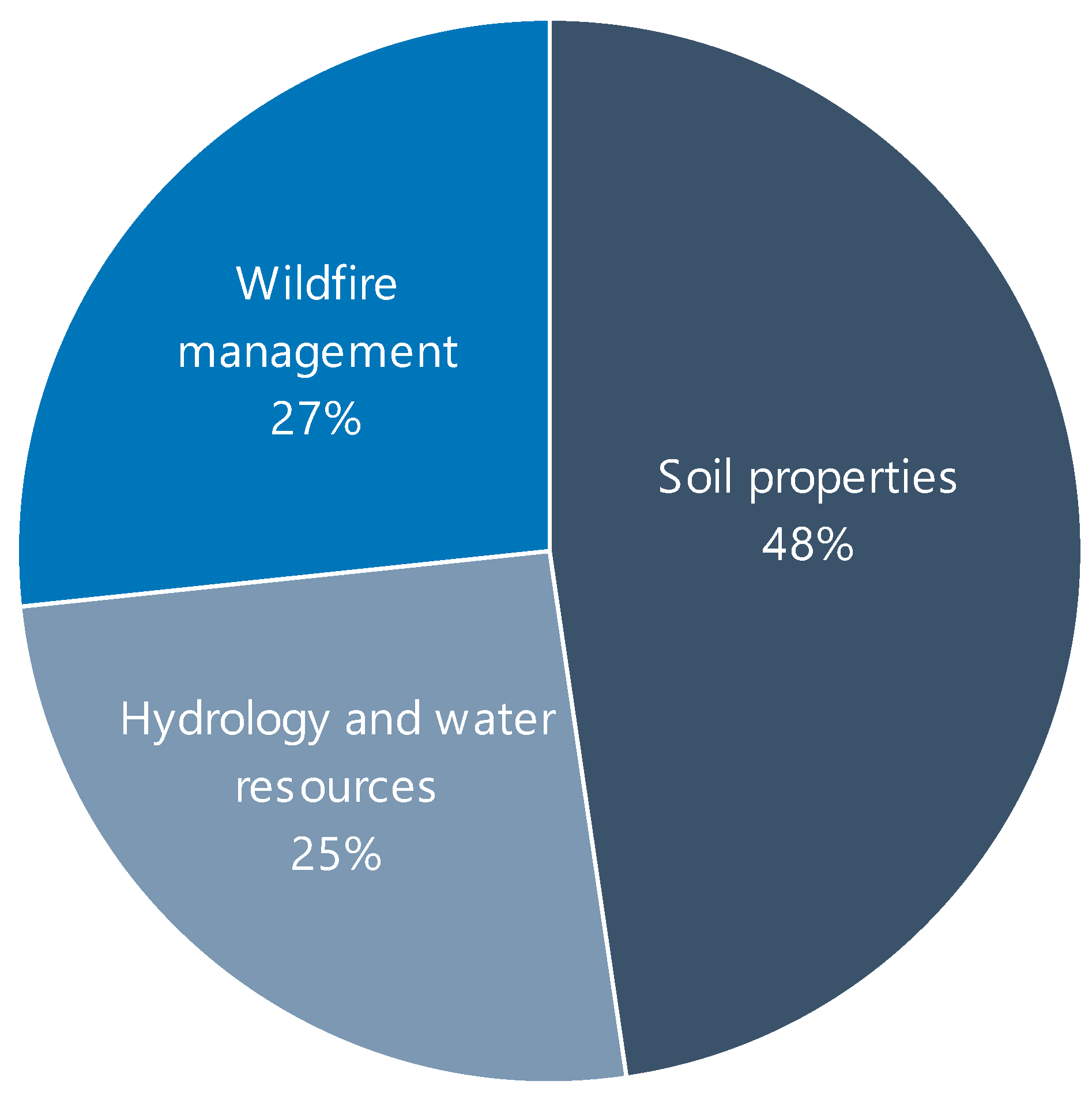
| Research Fields | Subcategorized Subjects | Number of Publications |
|---|---|---|
| Soil properties | Soil conductivity [34,35,36], soil salinity [28,37,38,39,40,41,42,43,44,45,46,47,48,49,50,51,52,53,54,55,56], SOC [57,58,59,60,61,62,63,64,65,66,67,68,69,70,71], soil aggregate stability [72,73], soil chemistry [31,74], soil degradation [75], soil erodibility [76,77,78,79], soil matric potential [80], soil mercury [81], soil moisture [82,83,84,85,86,87,88,89,90,91,92,93,94,95,96,97,98,99,100,101,102,103,104,105,106,107,108], soil nutrients [109,110,111], soil total nitrogen [112], soil respiration [113], soil stiffness [114], soil texture [115,116,117], soil types [118], soil organic matter [119,120,121,122], soil water content and evapotranspiration [123] | 93 |
| Hydrology and water resources | Groundwater level [124,125], streamflow [126], surface water [127,128], water storage [129], sediment concentration [130], algal blooms [131], Secchi disk depth [132], sediment discharge [133], water quality [134,135,136,137,138,139,140,141,142,143,144,145,146,147,148,149,150,151,152,153,154,155,156,157,158], turbidity [159,160,161,162,163,164], evapotranspiration [165,166], flash flood water depth [167], inundation status [168], ocean surface CO2 [169] | 50 |
| Wildfire management | Wildfire prediction [32,170,171,172,173,174,175,176,177,178,179,180,181,182,183,184,185,186,187,188,189,190], wildfire monitoring [25,33,191,192,193,194,195,196,197,198,199,200,201,202,203,204,205,206,207,208,209,210,211,212,213,214,215], wildfire recovery [216,217] | 52 |
| Research Fields | Number of Publications | Top Three Most Used RS Data | |
|---|---|---|---|
| Algorithms | Frequency of Usage | ||
| Soil properties | 93 | (1) Landsat 8 | 32 |
| (2) Sentinel-2 | 28 | ||
| (3) MODIS | 22 | ||
| Hydrology and water resources | 50 | (1) Landsat 8 | 18 |
| (2) Sentinel-2 | 16 | ||
| (3) Rapid Eye | 7 | ||
| Wildfire management | 52 | (1) MODIS | 20 |
| (2) Sentinel-2 | 15 | ||
| (3) Landsat 8 | 10 | ||
| Research Fields | Number of Publications | Top Three Most Used RS Data | |
|---|---|---|---|
| Algorithms | Frequency of Usage | ||
| Soil properties | 93 | (1) RF | 67 |
| (2) ANN | 23 | ||
| (3) SVM | 21 | ||
| Hydrology and water resources | 50 | (1) RF | 32 |
| (2) SVM, SVR | 14 | ||
| (3) XGB | 9 | ||
| Wildfire management | 52 | (1) RF | 30 |
| (2) SVM | 16 | ||
| (3) MLP | 7 | ||
Disclaimer/Publisher’s Note: The statements, opinions and data contained in all publications are solely those of the individual author(s) and contributor(s) and not of MDPI and/or the editor(s). MDPI and/or the editor(s) disclaim responsibility for any injury to people or property resulting from any ideas, methods, instructions or products referred to in the content. |
© 2024 by the authors. Licensee MDPI, Basel, Switzerland. This article is an open access article distributed under the terms and conditions of the Creative Commons Attribution (CC BY) license (https://creativecommons.org/licenses/by/4.0/).
Share and Cite
Kim, Y.I.; Park, W.H.; Shin, Y.; Park, J.-W.; Engel, B.; Yun, Y.-J.; Jang, W.S. Applications of Machine Learning and Remote Sensing in Soil and Water Conservation. Hydrology 2024, 11, 183. https://doi.org/10.3390/hydrology11110183
Kim YI, Park WH, Shin Y, Park J-W, Engel B, Yun Y-J, Jang WS. Applications of Machine Learning and Remote Sensing in Soil and Water Conservation. Hydrology. 2024; 11(11):183. https://doi.org/10.3390/hydrology11110183
Chicago/Turabian StyleKim, Ye Inn, Woo Hyeon Park, Yongchul Shin, Jin-Woo Park, Bernie Engel, Young-Jo Yun, and Won Seok Jang. 2024. "Applications of Machine Learning and Remote Sensing in Soil and Water Conservation" Hydrology 11, no. 11: 183. https://doi.org/10.3390/hydrology11110183
APA StyleKim, Y. I., Park, W. H., Shin, Y., Park, J.-W., Engel, B., Yun, Y.-J., & Jang, W. S. (2024). Applications of Machine Learning and Remote Sensing in Soil and Water Conservation. Hydrology, 11(11), 183. https://doi.org/10.3390/hydrology11110183