Perspective

Sea-Level Rise in Pakistan: Recommendations for Strengthening Evidence-Based Coastal Decision-Making

1
Met Office, Exeter EX1 3PB, UK
2
National Institute of Oceanography, Karachi 75600, Pakistan
3
School of Geographical Sciences, Faculty of Science, University of Bristol, Bristol BS8 1TD, UK
4
University of Liverpool, Liverpool L69 3BX, UK
5
National Oceanography Centre, Liverpool L3 5DA, UK
6
Pakistan Meteorological Department, Karachi 39350, Pakistan
7
Department of Maritime Sciences, Bahria University Karachi Campus, Karachi 75260, Pakistan
8
Institute of Environmental Studies, University of Karachi, Karachi 75270, Pakistan
9
International Union for Conservation of Nature, Islamabad44000, Pakistan
10
Global Change Impact Studies Centre, Ministry of Climate Change and Environmental Coordination, Islamabad 44000, Pakistan
11
Climate Change & Coastal Development Authority, Government of Sindh, Karachi 75500, Pakistan
*
Author to whom correspondence should be addressed.
Hydrology 2023, 10(11), 205; https://doi.org/10.3390/hydrology10110205
Submission received: 15 September 2023 / Revised: 11 October 2023 / Accepted: 16 October 2023 / Published: 25 October 2023
(This article belongs to the Special Issue Climate Change Effects on Coastal Management)

Abstract

:
Pakistan is vulnerable to a range of climate hazards, including sea-level rise. The Indus Delta region, situated in the coastal Sindh province, is particularly at risk of sea-level rise due to low-lying land and fragile ecosystems. In this article, expertise is drawn together from the newly established Pakistan Sea-Level Working Group, consisting of policy experts, scientists, and practitioners, to provide recommendations for future research, investment, and coastal risk management. An assessment of the current scientific understanding of sea-level change and coastal climate risks in Pakistan highlights an urgent need to improve the availability and access to sea-level data and other coastal measurements. In addition, reflecting on the policy environment and the enablers needed to facilitate effective responses to future sea-level change, recommendations are made to integrate coastal climate services into the National Adaptation Plan and develop a National Framework for Climate Services. Such a framework, alongside collaboration, co-production, and capacity development, could help support required improvements in coastal observations and monitoring and continuously deliver useful, usable, and accessible sea-level information for use by practitioners and decision-makers.

1. Introduction

Pakistan has consistently been ranked as one of the top ten countries most vulnerable to the impacts of climate change, which includes sea-level rise. Pakistan’s coastal belt is around 1120 km long [1], stretching from its western border with Iran at Jiwani to its eastern border with India at Sir Creek across two coastal provinces: Balochistan and Sindh (Figure 1). The Sindh coastline (348 km) can be subdivided into the Karachi and Indus Delta regions, where the Karachi region hosts two ports: Karachi Port and Bin Qasim Port. With a population of 15 million people recorded in the 2017 census and a growth rate of 2.35%, the population of Karachi city is expected to be more than 17 million today and it is the most populous and largest city in Pakistan [2]. The low-lying Indus Delta region covers an area of around 60,000 km2, stretching around 210 km where it meets the sea [3], and has around 94% of Pakistan’s mangroves [4]. The Indus Delta exhibits ongoing challenges due to upstream water management interventions, which have affected water and sediment flow across the delta and driven river flooding, erosion, saltwater intrusion, and ecosystem deterioration (see Section 3). Due to these factors, Sindh is considered to be at higher risk from the impacts of sea-level rise than Balochistan [5].
The Intergovernmental Panel on Climate Change (IPCC)’s Sixth Assessment Report (AR6) projected a likely global mean sea-level (GMSL) rise of 0.44 to 0.76 m under an intermediate greenhouse gas emissions scenario (where likely characterises the central two-thirds of the probability distribution). Under high emissions, the projected GMSL rise is 0.63–1.01 m, and above the likely range, a GMSL rise approaching 2 m “cannot be ruled out” due to deep uncertainty associated with rapid ice sheet melt [6]. Sea-level change is not globally uniform and may be exacerbated by additional processes driving regional-to-local scale variation in the rate of sea-level change (see Section 2.1). Hence, local sea-level information is needed to guide coastal planning decisions. Since some of the physical processes contributing to sea-level change have a long response time to global warming (e.g., melting of polar ice sheets), even if a rapid reduction in greenhouse gas emissions is achieved, GMSL is “committed to rise for centuries to millennia” [6]. Pakistan, like other countries across the world, needs to plan and adapt to inevitable changes in sea level over the coming decades for risk to stay at the present levels [7]. However, accessible, long-duration sea-level data along Pakistan’s coastline remain sparse (see Section 2), leading to issues when making localised decisions at the coast.
Pakistan’s National Climate Change Policy (NCCP; [8]) and Framework for Implementation of Climate Change Policy (2014 to 2030 [9]) outline key measures to protect coastal areas from sea-level rise and increasing climatic hazards. These include planting mangroves as a natural defence against erosion and storms, constructing barriers near infrastructure on low-lying land, and ensuring optimal river flow for sediment and nutrient supply to ecosystems and to deter the intrusion of saltwater. However, since only one functional channel of the Indus River remains (Khobar Creek) [10], no change is expected across the whole of the Indus Delta, even with the regular discharge of water in the river [11,12]. At the provincial level, in line with the NCCP, the Government of Sindh passed the Sindh Climate Change Policy in 2022 (SCCP) with a detailed Implementation Framework [13]. The SCCP addresses sea-level rise with specific actions and agencies responsible for taking action. A Climate Change Policy for Balochistan is also in development. Whilst these provincial government frameworks summarise the vision, policies, and strategies to address climate change, the tangible implementation of the policy will involve coordination and decision-making across different levels of governance, depending on the specific context and scope of the actions being undertaken.
Climate information, such as decadal-to-centennial projections of future mean sea level, can be provided and used to assist decision-making, such as in vulnerability testing for nuclear facilities [14]. To improve the coordination and quality control of such climate services, some countries have developed a National Framework for Climate Services (NFCS) [15]. An NFCS acts as a national interface platform to facilitate and strengthen collaboration between institutions across multiple (i.e., local, national, regional, and global) levels, enabling them to co-design, co-produce, communicate, deliver, and use climate services to build resilience in climate-sensitive sectors. NFCSs help to support the Paris Agreement and complement National Adaptation Plans (NAPs) since they improve the availability of scientific research and promote quality assurance, which acts to strengthen the evidence base for decision-making [16]. Such frameworks can help facilitate standardisation requirements in coastal climate services [17]. Whilst Pakistan’s NAP was delivered in August 2023 [18], Pakistan does not currently have an NFCS.
There is also a role for the international community to support and collaborate with organisations in Pakistan via various avenues such as technical assistance, capacity building, research collaboration, data sharing and funding support. The Asia Regional Resilience to a Changing Climate (ARRCC) programme, funded by the UK’s Foreign, Commonwealth and Development Office (FCDO), brought together cross-organisation collaboration and knowledge sharing via the organisation of a sea-level science training workshop and a science-policy webinar. Following discussion and recommendations in the webinar, a Pakistan Sea-Level Working Group was established by the Pakistan Meteorological Department (PMD), supported by the UK Met Office in May 2022 to bring together and support those involved in sea-level science and evidence to work towards coastal resilience in Pakistan. In addition, PMD established a Sea-level Monitoring Unit, strengthening capacity and expertise in sea-level hazards to decision-making.
This article outlines the status of sea-level science and coastal risks in Pakistan and draws on the collective perspectives of the Sea-Level Working Group to provide policy- and research-relevant recommendations for improving Pakistan’s resilience to sea-level rise. In doing so, this article brings together the expertise of decision-makers, practitioners and scientists working at the forefront of coastal protection, policy, and research in Pakistan.
Figure 1. The coastline of Pakistan and its coastal provinces, Sindh and Balochistan. Pakistan stretches from its western border with Iran at Jiwani to its eastern border with India at Sir Creek. The downstream reaches of the Indus River are shown in blue [19]. Cyclones of tropical storm classification or higher from 1973 to 2023 are shown in dotted light red [20] (Cyclone Biparjoy is shown in dark red). Fault lines are also shown, including trench (dark orange [21,22]) and transform (light orange [21]) types, to illustrate the hazard profile. Map data: Google Maps, Google Imagery 2023, TerraMetrics 2023. Border data: Natural Earth.
Hydrology 10 00205 g001

2. Current Scientific Understanding

Understanding past and future local relative mean sea-level change using sea-level observations and projections, alongside analysis of extreme sea levels can help to identify the areas which are vulnerable to erosion, inundation, and storm surge impacts, and help inform coastal planning and adaptation strategies. This section outlines the current understanding of past, present, and future local mean sea-level change and extreme sea levels along Pakistan’s coastline.

2.1. Drivers of Sea-Level Rise Globally, Regionally and Locally

Under global warming, global mean sea-level rise is largely driven by the thermal expansion of the oceans and the addition of water mass due to the melting of glaciers and ice sheets on land. Changes in land water storage via dam impoundment or groundwater extraction also result in a net change in water mass in the oceans. Global mean sea level has risen faster over the 20th century than any previous three millennia, by 0.2 m from 1901 to 2018, and has accelerated since the 1960s to a rate of 3.7 mm/yr from 2006 to 2018 [6]. Sea-level rise is not uniform across the world due to variations in regional ocean circulation and density and gravitational, rotational, and solid-Earth deformational effects arising from water mass being added into the ocean., Whilst glacial lake outburst floods may lead to short-term local flooding in Pakistan [23], which could occur in phase with high tides, waves, or surge events to produce extreme sea levels (see Section 2.4), decreasing glacier coverage over longer timescales results in less gravitational attraction of nearby seas. Globally, vertical land movement processes (e.g., tectonic uplift, subsidence due to groundwater extraction, and the rebounding of the Earth’s crust from melted ancient ice load) can lead to substantial increases or decreases in local mean sea-level change relative to land. Many of the world’s largest coastal cities are found within or adjacent to deltas, which experience gradual subsidence due to natural processes and human activities. Such cities may experience highly localised areas of rapid subsidence, leading to faster rates of relative sea-level rise [24]. Any impact or risk assessment will therefore be limited by the accuracy of present-day subsidence rate estimates and projections for 21st-century subsidence.

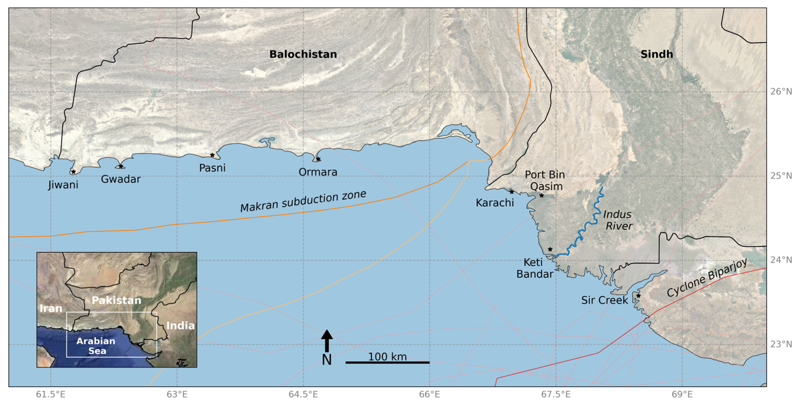
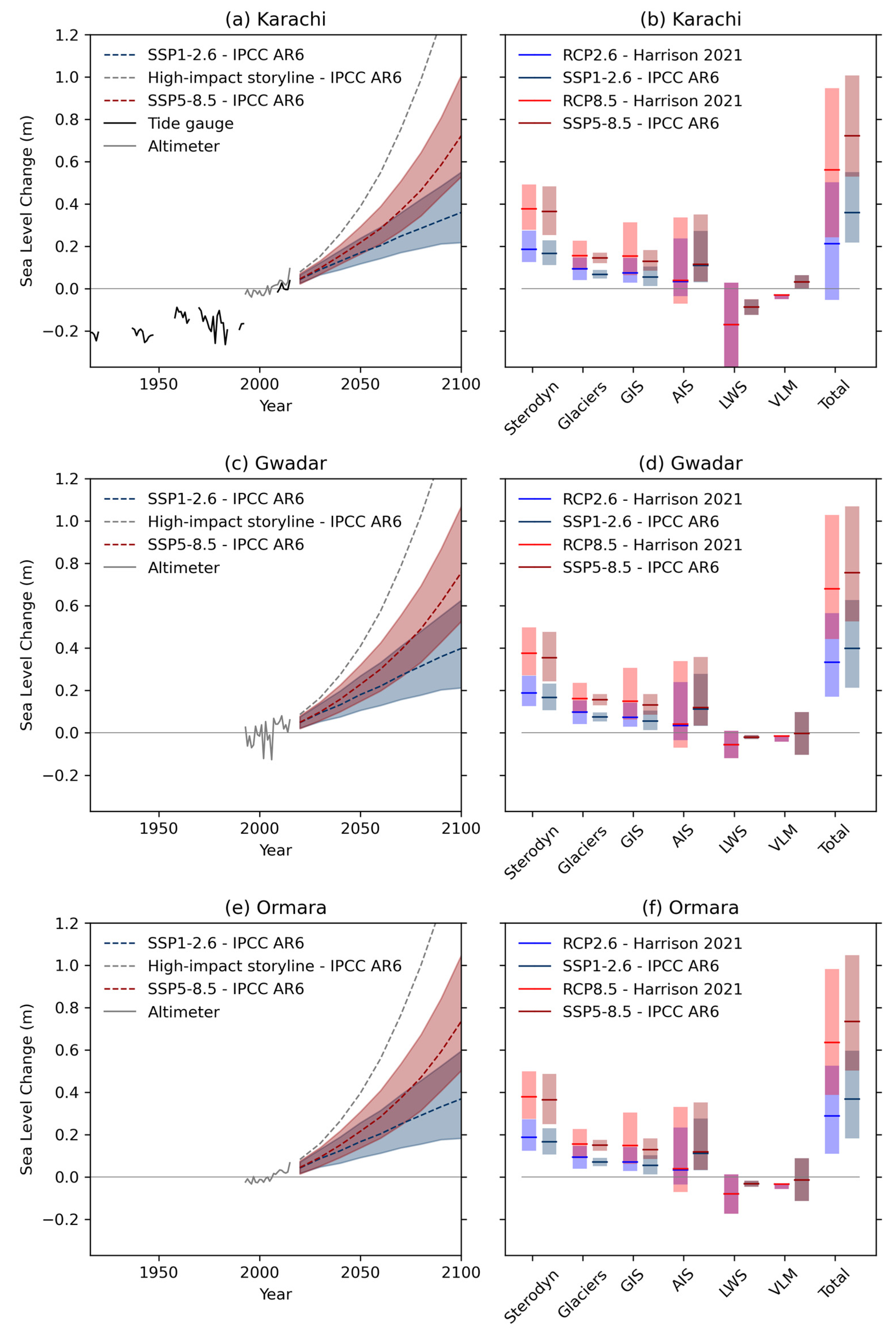
2.2. Observed Local Relative Mean Sea Level along Pakistan’s Coastline

Tide gauges in Pakistan are located at Karachi coast (data available from 1916), as well as Ormara, Gwadar, and Keti Bandar. The tide gauges at Keti Bandar, Gwadar, and Ormara are under the management of the Pakistan Navy Hydrographic Department, whilst the Karachi tide gauge is managed by Karachi Port Trust. The tide gauges are used for tsunami warnings and both sea-level and tidal analysis, with Gwadar and Karachi being part of the Global Sea Level Observing System (GLOSS) network. At present, only the Karachi tide gauge has active data on the Intergovernmental Oceanographic Commission (IOC) Sea-Level Monitoring Facility and the most recent and longest recorded research quality data available on the University of Hawaii Sea Level Center (UHSLC) and Permanent Service for Mean Sea Level (PSMSL). Annual data are available from 1868 [25], and more sparse data are available from as early as 1855 [26], making Karachi one of the longest time series from the region. These data were referenced to known benchmarks, and the sea level at Karachi was used as the reference datum level for the land survey of India in the 19th and early 20th centuries.
A sea-level trend from 1856 to 2000 of approximately 1.1 mm/yr was previously calculated using Karachi tide gauge observation data (Figure 2), and the reference of this rate by studies has frequently been used in the past as a base reference for understanding how sea-levels have changed along Pakistan’s coast, as well as described to align with global geocentric rates of sea-level change [27,28,29]. In comparison, ref. [25] calculated a sea-level rise trend of 0.97 mm/yr from 1868 to 1946, whilst later studies have calculated higher rates of observed sea-level rise at Karachi port of 2.0 mm/yr (1916 to 2016) [30] and 3.6 mm/yr (2007 to 2016) [31]. This indicates a sea-level rise acceleration similar to changes in global trends [32]. However, it is noted that 30 years of data is typically used for climate analysis to remove long-term variations. There are numerous large gaps in Karachi tide gauge data, including from 1921 to 1936, 1948 to 1957, and 1994 to 2007. Notably, the tide gauge location was moved around 1 km northwards from Manora Island to Kiamari in 2007. The datum was transferred across the harbour channel in 1993, and evidence from an analysis of trends [33], and buddy checking using multi-mission altimetry and tide gauge data from a small number of nearby sites [34], suggests a possible datum discontinuity associated with this data gap. This introduces a potential source of uncertainty when estimating longer-term trends for Karachi. Data archaeology may help resolve this issue and also fill some of the gaps in records; for example, it is possible to extract provisional observational data from 1922 to 1937 from records of differences between actual readings and predictions published annually in records of the Survey of India, as the predictions are also given. At the moment, analysis relies on the quality-controlled data available from the PSMSL and UHSLC, which has 10 years of data (up to 2017) from the modern radar gauge at Kiamari but has a much longer time series from 1868 to 1994 (with notable gaps) available from the Manora site.
Tide gauges measure sea-level change relative to land, which incorporates vertical land movement, though they can be co-located with GPS/GNSS measurements to correct for vertical land movement. Since satellite altimetry measures geocentric sea-level rise (which does not include vertical movement of the shore coastal land surface), subtracting satellite altimetry observations from tide gauge data can also be used to understand vertical land movement (for details, see [35,36]). In Pakistan, tide gauge data co-located with GNSS does not yet exist, and there are limited studies using satellite altimetry in sea-level trend analysis (e.g., [37]). Therefore, there is scope for these methods to be better integrated into research across disciplines. Obtaining satellite measurements close to the coast has typically been difficult. However, new processing techniques (e.g., retracking) have led to new products being available, which can be explored.

2.3. Projected Local Relative Mean Sea Level along Pakistan’s Coastline

Local mean sea-level projections at tide gauge locations in Pakistan were generated as part of a study under the ARRCC programme [38] (available to 2100 and 2300) and published alongside projections for the wider South Asia region [39]. Projections have also been published as part of the Intergovernmental Panel on Climate Change (IPCC)’s sixth Assessment Report (AR6 [6,40,41]) (Figure 2). The methods used by [38,39] were rooted in Coupled Model Intercomparison Project Phase 5 (CMIP5) models and IPCC AR5 methods, following [42,43], forced by the Representative Concentration Pathway (RCP) emissions scenarios to 2100. In contrast, IPCC AR6 projections were rooted in CMIP6 models and forced by Shared Socioeconomic Pathway (SSP) emissions scenarios, matched to appropriate radiative forcings used in the RCPs. AR6 medium confidence sea-level projections extend to 2150 (see [44,45,46] for comparisons of these sea-level projection methods). According to IPCC AR6, a 1 m sea-level change would be reached at Karachi under high emissions (SSP5-8.5) by around 2110 or under lower emissions (SSP1-2.6) by around 2160 [6,40,41]. Ref. [39] identified the sterodynamic contribution and future groundwater extraction as the foremost drivers of sea-level change and spatial variations, respectively, in South Asia, including Pakistan.
Figure 2a,c,e show observed sea-level change from tide gauges and satellite imagery and projected sea-level rise to 2100 from IPCC AR6. AR6 also provided low confidence, low-likelihood, high-impact local sea-level projections incorporating “runaway” ice sheet instability mechanisms, as shown in Figure 2. The projections are shown for the likely range, which characterises the central two-thirds of the probability distribution [39,47]. Also shown is a component and total sea-level change comparison between Harrison et al. and AR6 projections, where a tabulated comparison can be found in the Supplementary Materials (it is noted that the projections of Harrison et al. were regenerated for the present study using the same methods to align coordinates with IPCC AR6 although has a minimal effect on the results, and therefore, we refer to these projections as the peer-reviewed Harrison et al. [39]). Local mean sea-level change along Pakistan’s coastline is driven by negative changes in land water storage and large uncertainties in vertical land movement processes on decadal to centennial timescales. AR6 projections are generally higher than Harrison et al., the latter projecting the likely range sea-level change at 2100 to be 0.24 m to 0.95 m at Karachi, 0.39 m to 0.98 m at Ormara, and 0.44 m to 1.03 m at Gwadar under high emissions (RCP8.5). The lower bound under RCP2.6 in Harrison et al. indicates a trend towards negative total sea-level change, whilst, in AR6, the time series shows a more definite sea-level rise. Differences arise from the Antarctic ice sheet, land water storage and vertical land movement contributions to sea-level change, with higher values in AR6 due to different methods used [44]. The land water storage component in this region is affected by strong gradients in gravitational, rotational, and solid-Earth deformational patterns and is therefore impacted by spatial uncertainty in patterns used. The vertical land movement component considers only glacial isostatic adjustment in Harrison et al., whereas IPCC AR6 includes all processes as captured by tide gauges, including human-driven subsidence and tectonic uplift. Whilst the AR6 method includes vertical land movement processes that are important for Pakistan, it uses a “spatiotemporal statistical model of tide gauge data” [6] and is therefore affected by their regional distribution. In addition, ref. [48] found that observed vertical land movement can be more spatially variable than represented in AR6 projections. A better understanding of sea-level drivers such as vertical land movement and land water storage via improved monitoring would therefore help refine projected sea-level change in Pakistan.
Figure 2. A comparison of observed and projected total local sea-level including the high-impact low-likelihood storyline (a,c,e) at tide gauge locations in Pakistan (Karachi, Gwadar, and Ormara) from IPCC AR6, ref. [6,37,38,39,40,41], driven by SSP emissions scenarios. Also shown are total and component projections at 2100 (b,d,f) from Harrison et al. [38] following methods used in [39,40,41,42,43], driven by RCP emissions scenarios (left bars) and from IPCC AR6 (right bars) and observed sea-level records from tide gauges (black) and satellite altimetry (grey). Sterodyn = sterodynamics (ocean circulation and density). GIS = Greenland ice sheet. AIS = Antarctic ice sheet. LWS = Land Water Storage. VLM = Vertical Land Movement. At Karachi at 2100, the lower bound of Harrison et al. LWS reaches −0.38 m, whilst the upper bound of the IPCC AR6 high-impact storyline is 1.57 m. Tide gauge data source: Permanent Service for Mean Sea Level [49]. Satellite altimetry data source: European Space Agency Climate Change Initiative for Observations of Sea Level [50].
Hydrology 10 00205 g002

2.4. Extreme Sea-Level Analysis

Extreme sea levels are exceptionally high or low local seawater levels due to the combined short-term effects of storm surges, tides, and waves [6]. Sea-level rise acts to shorten the return periods of sea-level extreme events. To analyse future extreme sea levels, the effect of tides, storm surges (including cyclones), and waves need to be combined with mean sea-level projections (Section 2.3). This is important since extreme sea levels drive coastal flooding and erosion (Section 3.2). In the past, extreme sea-level events along Pakistan’s coastline have caused infrastructure damage, the disruption of transportation and wetland loss, and the relocation of communities [51].
An analysis of extreme sea-level events for Pakistan was carried out by [31]. This study used the 10 years of Karachi tide gauge hourly data (2007 to 2016) to ascertain extreme sea-level return periods [31] and observed an increase in the rate of change in extreme sea levels (+2.1 mm/year), driven by sea-level rise with a prominent contribution from the tidal component; Pakistan has semi-diurnal tides with diurnal inequality, with a mean tidal range of 2.3 m at Karachi port. The study concluded that advanced monitoring of sea levels via the installation and maintenance of tide gauges in Sindh and Balochistan would improve understanding of the extreme sea-level hazard [31] (see Section 4, Recommendation 2).
Extreme sea levels in Pakistan have been affected by tropical cyclones such as Gonu (2007), Yemyin (2007), and Phet (2010). Cyclone Biparjoy (2023) was the longest-lasting cyclone in the history of the Arabian Sea, lasting 12 days compared to the average cyclone lifespan of 5 to 6 days in this area. Alerts during Cyclone Biparjoy from PMD predicted very rough sea conditions with up to 2.5 m of storm surge near Keti Bandar, Southeast of Karachi. The total population evacuated from the Karachi, Badin, Thatta, and Sujawal coastal districts totalled 84,610, with over 2500 houses damaged, nearly 1800 livestock lost, and over 1000 acres of crop area damaged, as noted by the Provincial Disaster Management Authority. In recent years, the Arabian Sea has experienced more frequent and intense tropical cyclones, correlated with increasing temperatures in the surface and deeper waters [52]. Research suggests tropical cyclones have shifted westward in the North Indian Ocean over the last 30 years [53,54], whilst the probability of late-season severe tropical storms in the Arabian Sea has likely increased under anthropogenic forcing [55,56]. Due to resolution limitations of global climate models in simulating key tropical cyclone features, there is little consensus on local scale projections [57], although increased anthropogenic warming has the potential to increase the intensity of extremely severe and higher category tropical cyclones in the North Indian Ocean [58]. The most confident statement that can be formed about future tropical cyclones is that sea-level rise will increase the risk of extreme sea levels via higher storm surges and inundation [59]. Impacts on the changing vulnerability and exposure profile should also be considered, for example, if tropical cyclones cross the paths of major shipping routes via the Arabian Sea or new communities. Advanced monitoring of meteorological phenomena is therefore important for understanding future coastal risk [31] and for developing adaptation strategies to limit the impacts on coastal communities.
Flood inundation driven by extreme sea levels can also impact communities. Future flood inundation mapping studies for Pakistan’s coastline have typically employed coarse Digital Elevation Model (DEM) data (e.g., [60]), which may indicate regional changes but not provide local information relevant for decision-making. Uncertainty in open-access, global DEM data can be on the same order of magnitude as sea-level rise, however accurate, local DEM data has limited availability [61]. Whilst new satellite LiDAR elevation data products are emerging, drones or unmanned aerial vehicles could present lower-cost opportunities for DEM data collection (e.g., [62,63]).

3. Coastal Risks in Pakistan and Ongoing Initiatives

This section expands on coastal risks in Pakistan, focusing on scientific understanding and current research projects on coastal hazards, vulnerability, and exposure. The knowledge described combines the findings of a literature review conducted under the ARRCC programme in 2020 [64], along with the expertise of members of the Pakistan Sea-Level Working Group.

3.1. Tectonic Instability

Pakistan lies at the triple junction of the Indian, Eurasian, and Arabian plate boundaries and exhibits tectonic instability, with the Makran subduction zone situated offshore Balochistan (Figure 1) [65,66]. As a consequence, Pakistan experiences both onshore and offshore earthquakes, which can cause small islands to appear in the Arabian Sea (e.g., the 2013 Zalzala Koh mud volcano). The Balochistan coastline is understood to have an average uplift rate of 1 to 2 mm/yr [67], which in the past has been considered to cancel out with the aforementioned sea-level rise rate of 1.1 mm/yr [27]. However, using an average vertical land movement rate masks the spatiotemporal nature of the seismic cycle, including how vertical land movement might change during coseismic activity (e.g., subsiding land may suddenly uplift and vice versa). There is a need therefore to consider the full vertical land movement risk profile when considering local sea-level change.
In addition, earthquakes in the Makran region larger than 8 Mw could lead to large near-field tsunamis reaching Pakistan’s coastline in minutes [68,69]. In November 1945, a tsunami hitting Pakistan’s coastal belt caused estimated anomalous sea-level heights of 3 to 6 m at Gwadar, 9 m at Pasni, and 0.5 m to 2 m at Karachi [70,71]. Sea-level information recorded by tide gauges is therefore also important to feed into tsunami warning systems, alongside coordination and communication across all relevant stakeholders [69]. A United Nations Development Programme project with support from the government of Japan aimed to build community-level readiness for earthquakes and tsunamis by initiating a policy discourse on existing capacity and institutional arrangements of agencies involved in disaster risk reduction, preparedness, and response in the coastal areas of Pakistan.

3.2. Upstream Water Management in the Indus Delta

During the 20th century, human-driven upstream interventions for managing irrigation (e.g., dams, barrages and channels built after the Indus Water Treaty) resulted in a dramatic decrease in sediment, water and nutrients being delivered to the ocean [51]. In addition, large-scale engineering projects such as the Left Bank Outfall Drain have exhibited failures, impacting the sediment budget across the delta, and leading to widespread river flooding in Sindh. The vulnerability and exposure of the delta resulting from such interventions were evident during the widespread and widely reported river flooding in 2010 and 2022, which followed heavy monsoon rainfall. For example, ref. [72] found of the 2010 flooding that “most damage was caused by dam and barrage-related backwater effects, reduced water and sediment conveyance capacity, and multiple failures of irrigation system levees”. With reduced sediment and water transport in the Indus Delta towards the coast, the number of distributary channels has significantly reduced “from 17 channels in 1861 to just 1 significant channel in 2000” [10], and the rate of aggradation has become insufficient to keep up with local sea-level rise [73]. Alongside tectonic activity and groundwater abstraction, the delta exhibits subsidence. The resulting increases in high water levels at the coast can cause issues for livelihoods and ecosystems.

3.3. Saltwater Intrusion

The intrusion of saltwater into coastal groundwater aquifers can contaminate domestic and agricultural water resources. As is the case for deltas in other regions (e.g., the Mekong Delta), upstream hydrology may be the dominant process governing seawater intrusion, yet sea-level rise acts to exacerbate the hazard. Saltwater intrusion has already been seen in the Indus Delta over recent decades (e.g., Daboo Creek [74]) and has turned soils, groundwater and lakes brackish. The resulting environmental degradation and loss of cropland forces the migration of coastal inhabitants to more agriculturally prosperous areas [75].

3.4. Deterioration of Ecosystems

Mangroves (salt-tolerant trees and shrubs) have benefits for mitigating climate change and responding to coastal hazards. They can reduce the energy from a storm surge, their roots help stabilise soils to reduce erosion [76], and they store carbon (‘blue carbon’ [77]). Mangroves are also vital breeding grounds (e.g., fish, molluscs, and shrimp) and are therefore beneficial to the economy by supporting fisheries (e.g., Keti Bandar, [78]). Mangroves have historically adapted to sea-level rise via inland migration or increasing their vertical elevation (e.g., by sediment accretion). The former can occur if the path is not blocked by human infrastructure, whilst the latter in the geological past has only been possible up to an upper sea-level rise threshold rate of 7 mm/yr [79]. Over the last 50 years, Pakistan’s mangrove ecosystems have experienced a substantial decrease in the total cover and number of species, driven by a reduction in freshwater flow, pollution, urbanisation (such as turning wetlands into development land), overgrazing, and firewood harvesting [4,80,81,82]. The deterioration of the mangrove ecosystem, alongside illegal fishing practices, overexploitation and destructive equipment, have also led to the declining productivity of fisheries in the Indus Delta [51]. In addition, the Indus River interventions have led to the endangerment of the Indus River dolphin [83].
In response, there have been initiatives to address deforestation and the impact of climate change on ecosystems and to conserve natural resources. The Government of Pakistan’s 10 Billion Trees programme aimed to restore, expand, and safeguard coastal ecosystems, particularly mangroves, to enhance their ecological functions and resilience. Activities have included engagement with local communities, stakeholders, and non-governmental organisations to promote livelihood opportunities and sustainable management practices and build community ownership. Under IUCN’s Mangroves for the Future (MFF) initiative, Astola Island, located in the east of the Pasni district of Balochistan, was developed as Pakistan’s first Marine Protected Area (MPA) by planting a large population of mangroves in addition to other eco-friendly measures [84]. The Sindh Forest Department has worked in collaboration with international organisations such as IUCN under donor agencies like the Asian Development Bank (ADB) and MFF on the rehabilitation of mangroves. This has driven community awareness along the Indus Delta. In addition, the Living Indus project focuses on ecological restoration of the Indus River basin, presenting a ‘menu’ of 25 interventions for policymakers, practitioners, and communities to support and lead. An assessment of mangrove sites in Pakistan by [85] showed such initiatives were having positive changes in mangrove cover. However, despite important conservation efforts, some public initiatives have faced challenges, and the upstream factors driving decline remain an issue (see Section 3.2), affecting the ultimate survival rate of restored mangroves [82]. The extent of mangroves has continued to decline in Pakistan, decreasing overall by 172.14 km2 from 1996 to 2020, according to Mangrove Watch [86].

3.5. Morphological Changes

Freshwater and sediment depletion in the Indus Delta, unplanned infrastructure developments (e.g., Clifton beach), dredging (e.g., Pasni Harbour [87]), wastewater disposal (e.g., Lyari River [88]), and mangrove deterioration have left Pakistan’s coastline vulnerable to erosion [31,89], and there have been significant morphological changes over the last century [90,91]. For example, breakwater construction to protect Pasni Fish Harbour in the early 1990s from wave action caused extensive siltation via the blockage of the longshore sediment transport across the harbour. This led to erosion on the other side of the breakwater and severe morphological changes in the adjacent Shadi Kaur River [89]. In addition, the Indus Delta region was found to have a west-to-east increasing erosional trend, with rates reaching 27.46 m/yr [92]. Some areas have seen coastal accretion due to land reclamation, for example, in southern Karachi [93]. A consultation between researchers, policymakers, and practitioners as part of a coastal erosion study by [89] identified the Indus Delta and Damb, Pasni, Gwadar, and Jiwani in Balochistan as hotpots requiring intervention on coastal erosion. Addressing the need for a coordinated approach to tackle erosion, the study recommended the development of a National Coastal Erosion Management plan and pilot implementations such as re-designing harbours and constructing flood protection walls.

3.6. Significant Infrastructure

Significant infrastructure resides along Pakistan’s coastline, which could suffer huge economic damages and cause severe pollution in the coastal and marine areas if sufficient planning for sea-level rise and associated hazards is not in place. For example, a number of power plants are situated along the coast due to the use of seawater in cooling. The intake and outfall water channels connected with these power plants could face serious issues during extreme sea-level conditions. In addition, Pakistan’s largest industrial area is situated in close proximity to the coast. A network of large-diameter pipes for draining stormwater is being installed along Clifton Beach. These pipes could become compromised during extreme sea-level conditions allowing floodwater to intrude into the residential and commercial areas and cause huge damage to the infrastructure. In these areas, dredging activities along Clifton Beach (which have shifted coastal material) have resulted in a general perception that sea levels are falling. Engagement with practitioners and communities on how local sea levels will change over the coming decades is therefore important to adapt to sea-level rise and to facilitate effective coastal planning measures which account for future changes in extreme sea-levels. In addition, any proposed land reclamation projects may change the bathymetry, which in turn affects tidal propagation, and will need to be carefully modelled to understand the resulting changes to local hydrodynamic conditions during extreme sea levels.

3.7. Ongoing Initiatives

Pakistan has not ensured any specific policy or plan that addresses particular levels of sea-level rise. However, considering the impending risk associated with sea-level rise, the country is taking measures to address the coastal vulnerabilities, such as strengthening coastal infrastructure, early warning systems, disaster management strategies, and preparedness of the community to respond to extreme sea-level events. This was demonstrated during Cyclone Biparjoy, when tens of thousands of coastal inhabitants were evacuated.
A five-year project, which commenced in 2021, is underway to monitor sea-level rise, seawater intrusion and land subsidence across the whole coastal belt of Pakistan, focusing on the Indus Delta creek system and coastal city flooding. This is being led by the National Institute of Oceanography in collaboration with the Pakistan Navy Hydrographic Department, Pakistan Council of Research in Water Resources and Pakistan Space and Upper Atmosphere Research Commission, funded under the Ministry of Science and Technology, Government of Pakistan. The project is expected to provide some vital data, for example, on land elevation (which could be used in high-resolution flood inundation modelling), vertical land movement, tidal observations, and shallow water bathymetry, and would also monitor any changes in the physical and geological parameters along the coast.
At the provincial level, the ADB-funded Sindh Coastal Resilience Project (SCRP) has proposed interventions to mitigate coastal risks such as saltwater intrusion and flooding and to build community capacity to facilitate long-term development, working with nature where feasible. The project aims to restore waterways, enabling the transport of freshwater and sediment towards the coast, which would help deter saltwater intrusion into the delta [75]. An interactive, open-source coastal management system for communicating flood and coastal risks across the delta will also be delivered, of which a demonstration tool is currently available (https://fooldome.github.io/ResilientCoasts/, accessed on 17 October 2023).
Pakistan’s coastline risks are well known across the scientific, political, and consultancy communities, and any further action taken would benefit from close collaboration and coordination between ongoing and future projects working at different scales (i.e., global, regional, national, and local initiatives). As mentioned in Section 1, this has been addressed by some countries via the implementation of an NFCS.

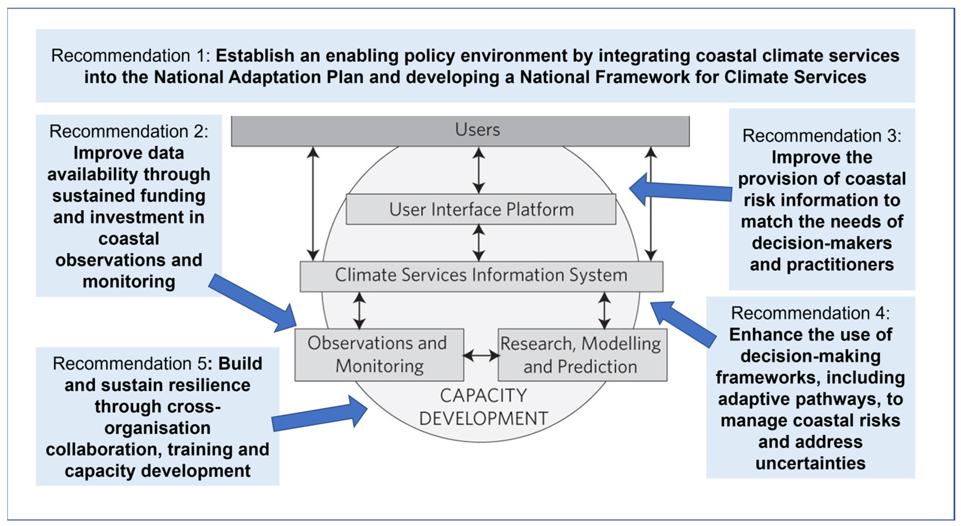
4. Recommendations to Strengthen Evidence-Based Coastal Planning and Resilience to Sea-Level Rise in Pakistan

At present, there is no clear evidence that local sea-level projections are being used to inform coastal decision-making and planning on Pakistan’s coastline. There also remains a need for deeper, active engagement with local communities on the long-term impacts and to incorporate their perspective, knowledge, and experiences into adaptation solutions to sea-level rise. In this section, five key recommendations are presented to strengthen scientific evidence and support an enabling environment to help build Pakistan’s resilience to sea-level rise. These recommendations, co-developed by the Pakistan Sea-Level Working Group, build on the assessment of scientific evidence and coastal risks discussed in previous sections and should act to complement and support ongoing initiatives.

4.1. Recommendation 1: Establish an Enabling Policy Environment by Integrating Coastal Climate Services into the National Adaptation Plan and Developing a National Framework for Climate Services

Pakistan has not yet developed an NFCS (Section 1). An NFCS, developed in collaboration with the government and relevant institutions following step-by-step guidance from the World Meteorological Organisation (WMO) and learnings from other countries, would provide an overall framework for the wider development of climate services in Pakistan [16]. A crucial element of the NFCS would be the inclusion of coastal climate services, supporting the coordination of institutions (Section 3.7) across the climate services value chain [94] to facilitate effective co-design, co-production, communication, delivery, and use of sea-level information. An NFCS would support Pakistan’s NAP by building adaptive capacity and reducing vulnerabilities to climate change impacts. The NAP would therefore benefit from the integration of coastal climate services into its implementation. An NFCS, alongside Pakistan’s NAP, would help build an enabling policy environment to facilitate further recommendations, as envisaged in Figure 3.
The coastal component of the NFCS could be informed by ongoing international coastal climate service projects working towards standardisation and improved data access (e.g., Coastal Climate Core Services; CoCliCo in Europe) and information accessibility (e.g., Coastal Hazard Wheel Program [95]), as well as coastal climate services frameworks outlined in the literature, such as those addressing community-based [96] and capacity building [97] approaches.

4.2. Recommendation 2: Improve Data Collection, Availability, and Quality through Sustained Funding and Investment in Coastal Monitoring and Observation Data

There is an urgent need to acquire real-time sea-level data (in a regular and systematic manner) along the coast and improve the availability of continuous, open-access sea-level data for Pakistan’s coastline (Section 2). A sea-level data network along the full coastline is required to monitor sea-level change, as well as monitor other coastal disasters such as tsunamis and long-distance swells. This means maintaining and upgrading existing tide gauges and installing additional instruments in strategic locations for co-assessment with other climatic variables (e.g., sea surface temperature and salinity). This network can be part of the Early Warning and Mitigation System for natural coastal disasters, aligning with WMO’s “Early Warnings for All” initiative.
It would be beneficial to co-locate tide gauge instruments with GNSS to better understand vertical land movement (subsidence or uplift) for local relative sea-level change (Section 2.2). Satellite-based monitoring combined with ground GPS data can enhance our understanding of trends in land vertical movements. Utilising existing GPS systems at the coast may be possible (e.g., [98]); however, it is dependent on strict requirements such as the distance between the tide gauge and the GNSS, as well as the local geology. In addition, topographic and beach slope surveys could be conducted to estimate past coastal inundation, beach line erosion and accretion, whilst investment in high-resolution flood inundation modelling (driven by emerging high-resolution DEM data) could help understand the potential future risk to local communities from sea-level rise and related hazards such as flooding and erosion.
Facilitating effective analysis requires tide gauge sea-level data to be continuously processed, quality assured and uploaded to open-source data portals, including PSMSL (monthly, annual), UHSLC (hourly, daily) and SONEL (GNSS), which would involve working directly with the portal developers. Detailed information on tide gauge benchmarking or instrument updates should be provided to assist with quality assurance (Section 2.2). A Pakistan Sea Level Data Portal could be developed to host sea-level data (across a range of timescales and available for any location), track local sea-level drivers, and host relevant research literature and training resources (see Recommendation 5).
The ability to install and maintain equipment, carry out research, and invest in required training will depend on adequate and sustainable funding. Challenges may also arise due to resources and allocation between organisations. In addition, some organisations have strict data-sharing policies which may restrict open-access publishing. In these cases, the data could be processed into a different open-access version or graphical representation. The Pakistan Sea-level Working Group could support the open sharing of data for real-time analysis of coastal hazards and sea-level rise.
Finally, to extend the observation record, data archaeology, and digitisation of manually recorded tide gauge logs could help study extreme sea levels over longer time periods and assist decision-makers (Section 2.2). This could be supported by citizen science and emerging machine learning techniques.

4.3. Recommendation 3: Improve the Provision and Communication of Coastal Risk Information to Match the Needs of Decision-Makers and Practitioners through Collaboration and Co-Production

At the national and provincial levels, comprehensive and adaptive strategies are required to be devised for the assessments of sea-level rise vulnerability, consequences, and risk management. In these assessments, a range of sea-level rise scenarios and their impending effects on communities, infrastructure, ecosystems and coastal areas should be taken into account. Local knowledge can help develop tailored coastal climate services and information for adaptation. For example, ‘mean sea level’ to coastal developers and beachfront dwellers is abstract, whilst they may find ‘high water mark’ and ‘low water mark’ more relevant. The extreme sea-level range is also more relevant for several biological species which are confined to the intertidal zone. Translating physical climate data into useful impact metrics for decision-making therefore requires a multidisciplinary approach, considering Pakistan’s social system and associated data [99], and engaging with coastal communities, local authorities, and other relevant stakeholders.
Authenticated sea-level information, such as national or provincial guidance on sea-level projections, could be developed, and reviewed and updated when necessary in a timely manner (i.e., such as feeding into national adaptation assessments) to ensure consistent, clear messaging to coastal decision-makers and practitioners (Section 2.3). This could be implemented in alignment with other climate projections, such as those provided by the Global Change Impact Studies Centre. It would be highly beneficial in this case to establish a specialised task force with professionals from relevant government agencies, research institutions, universities and stakeholders, to enable the co-design, co-production, and review of sea-level projections on a regular basis. The task force would also be responsible for communicating and disseminating sea-level projection guidance and its impacts to practitioners, decision-makers, and policymakers. This information could be provided via a Pakistan Sea-level Portal (as outlined in Recommendation 2).

4.4. Recommendation 4: Enhance the Use of Decision-Making Frameworks, including Adaptive Pathways, to Manage Coastal Risks and Address Uncertainties

Different tools for decision-making could be explored and used to manage uncertainty in projections of sea-level rise, following learnings from international projects. One example is the dynamic adaptive pathways approach, which has been applied in a variety of settings, including the Rhine Delta in the Netherlands [100] and the UK Thames Estuary 2100 plan [101] to identify timings of adaptation measures across multiple scenarios. This approach relies on robust observations and monitoring (see Recommendation 2), which trigger key decision points [102].
Sea-level scenarios and decision-making tools could be developed and applied in development plans, infrastructure projects and coastal zone management, as well as ecosystem-based adaptation, for example, supporting timely plantation of mangrove species (Section 3.4). This would involve building on engagement with coastal communities, local authorities, and other relevant stakeholders (see Section 3.4 and Section 3.7) in a multidimensional approach. Building the capacity of local communities to anticipate long-term change, such as retreat and relocation from the coast, will require proactive engagement with local communities over years to decades and involving communities in decision-making frameworks to understand and co-design adaptation options [102].

4.5. Recommendation 5: Build and Sustain Resilience through Cross-Organisation Collaboration, Training, and Capacity Development

Since sea-level information is typically managed by multiple organisations in Pakistan, tackling sea-level rise will require a robust, cross-organisation collaborative approach with sustained international partnerships, to ensure decisions are informed by up-to-date scientific consensus and learnings (Section 3.7). Maintaining momentum when international, collaborative projects conclude will also be essential. Key organisations in Pakistan include PMD, the National Institute of Oceanography, the Pakistan Navy Hydrographic Department, coastal development authorities and climate change departments of both Balochistan and Sindh, the Global Change Impact Study Centre, as well as universities and academic institutions, coastal and marine science departments of public and private sectors, port authorities (e.g., Karachi and Gwadar), and fisheries departments. International organisations such as the ADB, WMO, IUCN, Met Office, and WWF also have an important role (Section 3). Cross-organisation and international collaboration can be facilitated via the Pakistan Sea-Level Working Group and engagement with global activities such as those associated with the Ocean Decade network or communities of practice such as the Practitioner Exchange for Effective Response to Sea Level Rise (PEERS). Embedded researchers and visiting scientist secondments may be a way of improving partnerships between different organisations. It would be highly beneficial for scientific and technical project reports to be made publicly accessible as open-source, peer-reviewed publications, where possible, so that further studies can advance and build upon the latest scientific evidence and knowledge.
To ensure resilience is sustained, an accessible national training network could be established, including training university students and early career scientists on sea-level science and coastal climate services. This may require building or making use of existing training resources, which are then regularly updated and consistent with research quality datasets, or increasing funded Ph.D. programmes and building sea-level science modules into more university courses. Training resources available via the World Climate Research Programme Academy will also be important over the coming years, as well as attendance at international conferences and training workshops to share scientific knowledge and learnings.

5. Conclusions

Sea-level rise is expected to have severe economic implications for Pakistan (e.g., [28]). The implementation of the recommendations outlined above will rely on national policies and associated investment, driven by public support (in particular coastal communities), champions within the research and practitioner communities, and a conducive international policy context. Pakistan already has a need to respond to the aftermath and ongoing effects of both climatic and tectonic events and will undoubtedly need to face prioritisations. Given the increasing risks to Pakistan’s coastline amidst rising sea levels along with recent extreme weather conditions rising in the Arabian Sea, investing in solutions now will likely yield long-term socioeconomic benefits. Building coastal resilience to sea-level rise hazards necessitates a strengthened scientific evidence base. An NFCS, aligning with Pakistan’s NAP objectives and supporting coastal climate services initiatives, could then provide an enabling environment to pull through strengthened scientific evidence into useful sea-level rise metrics, connect different actors across the climate services value chain, and promote quality assurance in coastal climate services. This will help build Pakistan’s resilience to sea-level change in alignment with the Ocean Decade outcomes.

Supplementary Materials

The following supporting information can be downloaded at https://www.mdpi.com/article/10.3390/hydrology10110205/s1, Table S1: Comparison of local mean sea-level change (m).

Author Contributions

Conceptualization, J.H.W., J.D.D., B.J.H., N.R., A.I., F.A.K., A.K., T.M.A.K. and G.R.; Methodology, J.H.W., J.D.D., B.J.H. and G.R.; Formal Analysis, J.H.W. and P.H.; Investigation, J.H.W., B.J.H., N.R., A.I. and S.N.A.; Writing—Original Draft Preparation, J.H.W., N.R., A.I., B.J.H., J.D.D., A.A.Q., T.M.A.K., F.A.K., P.H. and G.R.; Writing—Review and Editing, A.I., N.R., S.S., T.I., A.K., S.N.A., A.A.Q., T.M.A.K. and F.A.K.; Visualization, J.H.W., J.D.D., B.J.H., A.I. and T.I. Co-authors are listed alphabetically under the manuscript title. All authors have read and agreed to the published version of the manuscript.

Funding

This work was supported by the ARRCC programme funded by the UK’s FCDO. This work pulls through the underpinning science developed under the Hadley Centre Climate Programme.

Data Availability Statement

No new data were created or analysed in this study. Data sharing is not applicable to this article. Projection data generated as part of [39] are available at: https://rds.icimod.org/Home/DataDetail?metadataId=1972957 (last accessed 18 October 23).

Acknowledgments

We thank the three reviewers whose comments and suggestions helped to improve the manuscript. We acknowledge the use of verified cyclone track records from the Joint Typhoon Warning Center and realtime records from Julian Heming as well as scripts developed in the Met Office by Tim Mitchell and others for plotting tropical cyclones. We acknowledge the use of satellite altimetry data from v2.0 of the European Space Agency Climate Change Initiative for Observations of Sea Level [50] and tide gauge data from Permanent Service for Mean Sea Level [49]. We thank the projection authors for developing and making the IPCC AR6 sea-level rise projections available, multiple funding agencies for supporting the development of the projections, and the NASA Sea Level Change Team for developing and hosting the IPCC AR6 Sea Level Projection Tool. We thank Eleanor Ainscoe for guidance on satellite and tectonic datasets for Figure 1. We thank Lujia Feng for providing guidance and references on the use of GNSS/GPS with tide gauges and on the tectonic setting. We thank Rachel Perks and Matthew Palmer for general guidance to help our scientific understanding and advice on sea-level monitoring and coastal management. We thank the developers of the Met Office Sea-level Tool for the use of the tool in generating local sea-level projections for Pakistan in Figure 2. We thank Chris Hewitt and WMO for permission to adapt their GCFS figure from [15] in Figure 3. We thank Mahmood Akhtar Cheema, Nadeem Shaukat, and all members of the Pakistan Sea-Level Working Group for their valuable input in discussions.

Conflicts of Interest

The authors declare no conflict of interest.

References

  1. Noman, M.; Mohsin, M.; Memon, A.M. Constraint analysis of major problems facing the marine fisheries sector in accordance with the national fisheries policy of Pakistan. Indian J. Geo-Mar. Sci. 2022, 51, 94–103. [Google Scholar] [CrossRef]
  2. Pakistan Bureau of Statistics. Population Census; Pakistan Bureau of Statistics: Islamabad, Pakistan, 2017. [Google Scholar]
  3. World Wide Fund for Nature, “Delta diversity”. 2023. Available online: https://wwf.panda.org/discover/knowledge_hub/where_we_work/indus_delta/ (accessed on 14 July 2023).
  4. MFF Pakistan. A Handbook on Pakistan’s Coastal and Marine Resources; MFF Pakistan: Mardan, Pakistan, 2016; Available online: http://www.mangrovesforthefuture.org/assets/Repository/Documents/A-Handbook-on-Pakistan-Coastal-and-Marine-Resources.pdf (accessed on 14 July 2023).
  5. Khan, T.M.A.; Rabbani, M.M. Sea Level Monitoring and Study of Sea Level Variations Along Pakistan Coast: A Component of Integrated Coastal Zone Management; National Institute of Oceanography: Paris, France, 2005; Available online: https://gloss-sealevel.org/sites/gloss/files/publications/documents/ge9-meeting-report-pakistan.pdf (accessed on 17 October 2023).
  6. Fox-Kemper, B.; Hewitt, H.; Xiao, C.; Aðalgeirsdóttir, G.; Drijfhout, S.; Edwards, T.; Golledge, N.; Hemer, M.; Kopp, R.; Krinner, G.; et al. Ocean, Cryosphere and Sea Level Change. In Climate Change 2021: The Physical Science Basis. Contribution of Working Group I to the Sixth Assessment Report of the Intergovernmental Panel on Climate Change; Masson-Delmotte, V., Zhai, P., Pirani, A., Connors, S.L., Péan, C., Berger, S., Caud, N., Chen, Y., Goldfarb, L., Gomis, M.I., et al., Eds.; Cambridge University Press: Cambridge, UK; New York, NY, USA, 2023; pp. 1211–1362. [Google Scholar] [CrossRef]
  7. Haasnoot, M.; Winter, G.; Brown, S.; Dawson, R.J.; Ward, P.J.; Eilander, D. Long-term sea-level rise necessitates a commitment to adaptation: A first order assessment. Clim. Risk Manag. 2021, 34, 100355. [Google Scholar] [CrossRef]
  8. Government of Pakistan. National Climate Change Policy; Government of Pakistan: Islamabad, Pakistan, 2021; Available online: https://faolex.fao.org/docs/pdf/pak211083.pdf (accessed on 14 July 2023).
  9. Government of Pakistan. Framework for Implementation of Climate Change Policy; Government of Pakistan: Islamabad, Pakistan, 2013. [Google Scholar]
  10. Syvitski, J.P.M.; Kettner, A.J.; Overeem, I.; Giosan, L.; Brakenridge, G.R.; Hannon, M.; Bilham, R. Anthropocene metamorphosis of the Indus Delta and lower floodplain. Anthropocene 2013, 3, 24–35. [Google Scholar] [CrossRef]
  11. Inam, A.; Clift, P.D.; Giosan, L.; Tabrez, A.R.; Rabbani, M.M.; Tahir, M.; Danish, M. The Geographic, Geological, and Oceanographic setting of the Indus River (Chapter 16). In Large Rivers: Geomorphology and Management; Gupta, A., Ed.; John Wiley Publisher: Hoboken, NJ, USA, 2007. [Google Scholar] [CrossRef]
  12. Inam, A.; Clift, P.D.; Giosan, L.; Alizai, A.; Kidwai, S.; Shahzad, M.I.; Zia, I.; Nazeer, M.; Khan, M.J.; Ali, S.S.; et al. The Geographic, Geological, and Oceanographic Setting of the Indus River–An Update. In Large Rivers: Geomorphology and Management, 2nd ed.; Gupta, A., Ed.; John Wiley & Sons, Ltd,: Hoboken, NJ, USA, 2022. [Google Scholar]
  13. Government of Sindh. Sindh Climate Change Policy. 2022. Available online: https://docc.sindh.gov.pk/files/DoCC/Documents/Sindh%20Climate%20Change%20Policy%202022%20(Final).pdf (accessed on 14 July 2023).
  14. Environment Agency; Office for Nuclear Regulation. Principles for Flood and Coastal Erosion Risk Management. Office for Nuclear Regulation and Environment Agency Joint Advice Note, no. July 2022–Revision 2. 2022, pp. 1–39. Available online: https://www.onr.org.uk/documents/2022/principles-for-flood-and-coastal-erosion-risk-management.pdf (accessed on 18 October 2023).
  15. Hewitt, C.; Mason, S.; Walland, D. The Global Framework for Climate Services. Nat. Clim. Chang. 2012, 2, 831–832. [Google Scholar] [CrossRef]
  16. World Meteorological Organization. Step-by-Step Guidelines for Establishing a National Framework for Climate Services. 2018. Available online: https://library.wmo.int/records/item/55867-step-by-step-guidelines-for-establishing-a-national-framework-for-climate-services (accessed on 18 October 2023).
  17. Le Cozannet, G.; Nicholls, R.J.; Hinkel, J.; Sweet, W.V.; McInnes, K.L.; Van de Wal, R.S.W.; Slangen, A.B.A.; Lowe, J.A.; White, K.D. Sea level change and coastal climate services: The way forward. J. Mar. Sci. Eng. 2017, 5, 49. [Google Scholar] [CrossRef]
  18. Ministry of Climate Change & Environmental Coordination. National Adaptation Plan Pakistan. 2023. Available online: https://unfccc.int/documents/631045 (accessed on 18 October 2023).
  19. Kidwai, S.; Ahmed, W.; Tabrez, S.M.; Zhang, J.; Giosan, L.; Clift, P.; Inam, A. The Indus Delta-Catchment, River, Coast, and People. In Coasts and Estuaries: The Future; Elsevier: Amsterdam, The Netherlands, 2019. [Google Scholar] [CrossRef]
  20. Chu, J.-H.; Sampson, C.R.; Levine, A.S.; Fukada, E. 2002: The Joint Typhoon Warning Center Tropical Cyclone Best-Tracks, 1945–2000. Naval Research Laboratory Tech Rep. NRL/MR/7540-02-16. Available online: https://www.metoc.navy.mil/jtwc/products/best-tracks/tc-bt-report.html (accessed on 27 April 2020).
  21. Berberian, M. Active faulting and tectonics of Iran. Zagros Hindu Kush Himalaya Geodyn. Evol. 1981, 3, 33–69. [Google Scholar] [CrossRef]
  22. Bordet, P.; Colchen, M.; Le Fort, P.; Pêcher, A. The geodynamic evolution of the Himalayaten Years of research in central Nepal Himalaya and some other regions. Zagros Hindu Kush Himalaya Geodyn. Evol. 1981, 3, 149–168. [Google Scholar] [CrossRef]
  23. United Nations Development Programme. Scaling-up of Glacial Lake Outburst Flood (GLOF) Risk Reduction in Northern Pakistan United Nations Development Programme. 2022. Available online: https://www.undp.org/pakistan/projects/scaling-glacial-lake-outburst-flood-glof-risk-reduction-northern-pakistan (accessed on 14 July 2023).
  24. Nicholls, R.J.; Lincke, D.; Hinkel, J.; Brown, S.; Vafeidis, A.T.; Meyssignac, B.; Hanson, S.E.; Merkens, J.L.; Fang, J. A global analysis of subsidence, relative sea-level change and coastal flood exposure. Nat. Clim. Chang. 2021, 11, 338–342. [Google Scholar] [CrossRef]
  25. Spencer, N.E.; Woodworth, P.L.; Pugh, D.T. Ancillary Time Series of Mean Sea Level Measurements. Permanent Service for Mean Sea Level, Bidston, Birkenhead. Appendices. 1988. Available online: https://psmsl.org/data/longrecords/ancill_rep.htm (accessed on 14 July 2023).
  26. Tennant, J.F. On Tidal Observations at Kurrachee in 1855. In Account of the Great Trigonometrical Survey of India; History and General Description of the Principal Triangulation and of its Reduction, Appendix 6; Walker, J.T., Ed.; Office of the Great Trigonometrical Survey: Dehra Dun, India, 1856; Volume 2, pp. 119–126. [Google Scholar]
  27. Quraishee, G.S. Global Warming and Rise in Sea Level in the South Asian Seas Region, in The Implication of Climatic Changes and the Impact of Rise in Sea Level in the South Asian Seas Region. Task Team Rep. 1988, 1–21. [Google Scholar]
  28. Rabbani, M.M.; Inam, A.; Tabrez, A.R.; Sayed, N.A.; Tabrez, S.M. The impact of sea level rise on Pakistan’s coastal zones—In a climate change scenario. In Proceedings of the 2nd International Maritime Conferenc, Karachi, Pakistan, 2–4 April 2008; pp. 25–27. [Google Scholar]
  29. Chaudhry, Q.U.Z. Climate Change Profile of Pakistan; Asian Development Bank: Manila, Philippines, 2017. [Google Scholar] [CrossRef]
  30. National Oceanic and Atmospheric Administration. Relative Sea Level Trend 490-021 Karachi, Pakistan. 2022. Available online: https://tidesandcurrents.noaa.gov/sltrends/sltrends_station.shtml?id=490-021 (accessed on 14 July 2023).
  31. Khan, F.A.; Khan, T.M.A.; Ahmed, A.N.; Afan, H.A.; Sherif, M.; Sefelnasr, A.; El-Shafie, A. Complex extreme sea levels prediction analysis: Karachi coast case study. Entropy 2020, 22, 549. [Google Scholar] [CrossRef]
  32. Frederikse, T.; Landerer, F.; Caron, L.; Adhikari, S.; Parkes, D.; Humphrey, V.W.; Dangendorf, S.; Hogarth, P.; Zanna, L.; Cheng, L.; et al. The causes of sea-level rise since 1900. Nature 2020, 584, 393–397. [Google Scholar] [CrossRef] [PubMed]
  33. Woodworth, P.; Foden, P.; Pugh, J.; Mathews, A.; Aarup, T.; Aman, A.; Nkebi, E.; Odametey, J.; Facey, R.; Esmail, M.Y.A.; et al. Insight into Long Term Sea Level Change Based on New Tide Gauge Installations at Takoradi, Aden and Karachi. Int. Hydrogr. Rev. 2009, 1, 18–23. [Google Scholar]
  34. Hogarth, P. Preliminary analysis of acceleration of sea level rise through the twentieth century using extended tide gauge data sets: Supplementary note 4: Indian Ocean (updated 24/2/2016). J. Geophys. Res. Ocean. 2014, 119, 7645–7659. [Google Scholar] [CrossRef]
  35. Pugh, D.; Woodworth, P. Sea-Level Science; Cambridge University Press: Cambridge, UK, 2014. [Google Scholar] [CrossRef]
  36. Gregory, J.M.; Griffies, S.M.; Hughes, C.W.; Lowe, J.A.; Church, J.A.; Fukimori, I.; Gomez, N.; Kopp, R.E.; Landerer, F.; Le Cozannet, G.; et al. Concepts and Terminology for Sea Level: Mean, Variability and Change, Both Local and Global. Surv. Geophys. 2019, 40, 1251–1289. [Google Scholar] [CrossRef]
  37. Naseer, T.; Vignudelli, S.; Zaidi, A. Study of Sea Surface Temperature (SST) and Sea Level Rise (SLR) Along Karachi Coast using Satellite Data, Pakistan. ECWS 2021. [Google Scholar] [CrossRef]
  38. Harrison, B.J. Sea Level Projections for South Asia: Report on Main Findings. 2020. Available online: https://www.metoffice.gov.uk/binaries/content/assets/metofficegovuk/pdf/business/international/report-on-regional-sea-level-projections-for-south-asia---arrcc-report---external-1.pdf (accessed on 18 October 2023).
  39. Harrison, B.J.; Daron, J.D.; Palmer, M.D.; Weeks, J.H. Future sea-level rise projections for tide gauge locations in South Asia. Environ. Res. Commun. 2021, 3, 115003. [Google Scholar] [CrossRef]
  40. Kopp, R.E.; Garner, G.G.; Hermans, T.H.J.; Jha, S.; Kumar, P.; Slangen, A.B.A.; Turilli, M.; Edwards, T.L.; Gregory, J.M.; Koubbe, G.; et al. The Framework for Assessing Changes to Sea-level (FACTS) v1.0-rc: A Platform for Characterizing Parametric and Structural Uncertainty in Future Global, Relative, and Extreme Sea-Level Change to Sea-Level (FACTS). EGUsphere 2023. preprint. [Google Scholar] [CrossRef]
  41. Garner, G.G.; Hermans, T.; Kopp, R.E.; Slangen, A.B.A.; Edwards, T.L.; Levermann, A.; Nowikci, S.; Palmer, M.D.; Smith, C.; Fox-Kemper, B.; et al. IPCC AR6 Sea Level Projections. Version 20. Available online: https://zenodo.org/record/6382554 (accessed on 17 July 2023).
  42. Palmer, M.; Howard, T.; Tinker, J.; Lowe, J.; Bricheno, L.; Calvert, D.; Edwards, T.; Gregory, J.; Harris, G.; Krijnen, J.; et al. UKCP18 Marine Report. 2018. Available online: https://www.metoffice.gov.uk/binaries/content/assets/metofficegovuk/pdf/research/ukcp/ukcp18-marine-report-updated.pdf (accessed on 14 July 2023).
  43. Palmer, M.D.; Gregory, J.M.; Bagge, M.; Calvert, D.; Hagedoorn, J.M.; Howard, T.; Klemann, V.; Lowe, J.A.; Roberts, C.D.; Slangen, A.B.A.; et al. Exploring the Drivers of Global and Local Sea-Level Change Over the 21st Century and Beyond. Earth’s Future 2020, 8, e2019EF001413. [Google Scholar] [CrossRef]
  44. Slangen, A.B.A.; Palmer, M.D.; Camargo, C.M.L.; Church, J.A.; Edwards, T.L.; Hermans, T.H.J.; Hewitt, H.T.; Garner, G.G.; Gregory, J.M.; Kopp, R.E.; et al. The evolution of 21st century sea-level projections from IPCC AR5 to AR6 and beyond. Cambridge Prism. Coast. Future 2023, 1, E7. [Google Scholar] [CrossRef]
  45. Weeks, J.H.; Harrison, B.J.; Daron, J.D. A Comparison of Local Sea-Level Projections for South Asia. 2022. Available online: https://www.metoffice.gov.uk/binaries/content/assets/metofficegovuk/pdf/business/international/arrcc-wp3_summary_ar6_sea-level_projections_final.pdf (accessed on 14 July 2023).
  46. Weeks, J.H.; Fung, F.; Harrison, B.J.; Palmer, M.D. The evolution of UK sea-level projections. Environ. Res. Commun. 2023, 5, 032001. [Google Scholar] [CrossRef]
  47. Kopp, R.; Oppenheimer, M.; O’Reilly, J.L.; Drijfhout, S.S.; Edwards, T.L.; Fox-Kemper, B.; Garner, G.G.; Golledge, N.R.; Hermans, T.H.; Hewitt, H.T.; et al. Communicating Projection Uncertainty and Ambiguity in Sea-Level Assessment. (Unpublished). Available online: https://authorea.com/doi/full/10.1002/essoar.10511663.1 (accessed on 14 July 2023).
  48. Tay, C.; Lindsey, E.O.; Chin, S.T.; McCaughey, J.W.; Bekaert, D.; Nguyen, M.; Hua, H.; Manipon, G.; Karim, M.; Horton, B.P.; et al. Sea-level rise from land subsidence in major coastal cities. Nat. Sustain. 2022, 5, 1049–1057. [Google Scholar] [CrossRef]
  49. Holgate, S.J.; Matthews, A.; Woodworth, P.L.; Rickards, L.J.; Tamisiea, M.E.; Bradshaw, E.; Foden, P.R.; Gordon, K.M.; Jevrejeva, S.; Pugh, J. New data systems and products at the permanent service for mean sea level. J. Coast. Res. 2013, 29, 493. [Google Scholar] [CrossRef]
  50. Legeais, J.F.; Ablain, M.; Zawadzki, L.; Zuo, H.; Johannessen, J.A.; Scharffenberg, M.G.; Fenoglio-Marc, L.; Joana Fernandes, M.; Baltazar Andersen, O.; Rudenko, S.; et al. An improved and homogeneous altimeter sea level record from the ESA Climate Change Initiative. Earth Syst. Sci. Data 2018, 10, 281–301. [Google Scholar] [CrossRef]
  51. Kidwai, S.; Fanning, P.; Ahmed, W.; Tabrez, M.; Zhang, J.; Khan, M.W. Practicality of marine protected areas-Can there be solutions for the River Indus delta? Estuar. Coast. Shelf Sci. 2016, 183, 349–359. [Google Scholar] [CrossRef]
  52. Dasgupta, A. Arabian Sea emerging as a cyclone hotspot. Nat. India 2021. [Google Scholar] [CrossRef]
  53. Murakami, H.; Delworth, T.L.; Cooke, W.F.; Zhao, M.; Xiang, B.; Hsu, P.-C. Detected climatic change in global distribution of tropical cyclones. Proc. Natl. Acad. Sci. USA 2020, 117, 10706–10714. [Google Scholar] [CrossRef] [PubMed]
  54. Wang, S.; Toumi, R. Recent migration of tropical cyclones toward coasts. Science 2021, 371, 514–517. [Google Scholar] [CrossRef] [PubMed]
  55. Seneviratne, S.I.; Zhang, X.; Adnan, M.; Badi, W.; Dereczynski, C.; Di Luca, A.; Ghosh, S.; Iskandar, I.; Kossin, J.; Lewis, S.; et al. Weather and Climate Extreme Events in a Changing Climate. In Climate Change 2021—The Physical Science Basis; Masson-Delmotte, B.Z., Zhai, P., Pirani, A., Connors, S.L., Péan, C., Berger, S., Caud, N., Chen, Y., Goldfarb, L., Gomis, M.I., et al., Eds.; Cambridge University Press: Cambridge, UK; New York, NY, USA, 2021; pp. 1513–1766. [Google Scholar] [CrossRef]
  56. Murakami, H.; Vecchi, G.A.; Underwood, S. Increasing frequency of extremely severe cyclonic storms over the Arabian Sea. Nat. Clim. Chang. 2017, 7, 885–889. [Google Scholar] [CrossRef]
  57. Murakami, H.; Sugi, M. Effect of Model Resolution on Tropical Cyclone Climate Projections. SOLA 2010, 6, 73–76. [Google Scholar] [CrossRef]
  58. Swapna, P.; Sreeraj, P.; Sandeep, N.; Jyoti, J.; Krishnan, R.; Prajeesh, A.G.; Ayantika, D.C.; Manmeet, S. Increasing Frequency of Extremely Severe Cyclonic Storms in the North Indian Ocean by Anthropogenic Warming and Southwest Monsoon Weakening. Geophys. Res. Lett. 2022, 49, e2021GL094650. [Google Scholar] [CrossRef]
  59. Knutson, T.; Camargo, S.J.; Chan, J.C.L.; Emanuel, K.; Ho, C.-H.; Kossin, J.; Mohapatra, M.; Satoh, M.; Sugi, M.; Walsh, K.; et al. Tropical Cyclones and Climate Change Assessment: Part II: Projected Response to Anthropogenic Warming. Bull. Am. Meteorol. Soc. 2020, 101, E303–E322. [Google Scholar] [CrossRef]
  60. Bakhsh, H.A.; Rehman, H.U.; Shakir, A.S.; Khan, N.M. Flood inundation modeling under present and future scenarios of mean sea levels for the Hub River watershed. J. Chin. Inst. Eng. 2017, 40, 1–9. [Google Scholar] [CrossRef]
  61. Hawker, L.; Rougier, J.; Neal, J.; Bates, P.; Archer, L.; Yamazaki, D. Implications of Simulating Global Digital Elevation Models for Flood Inundation Studies. Water Resour. Res. 2018, 54, 7910–7928. [Google Scholar] [CrossRef]
  62. Young, S.S.; Wamburu, P. Comparing Drone-Derived Elevation Data with Air-Borne LiDAR to Analyze Coastal Sea Level Rise at the Local Level. Pap. Appl. Geogr. 2021, 7, 331–342. [Google Scholar] [CrossRef]
  63. Vernimmen, R.; Hooijer, A. New LiDAR-Based Elevation Model Shows Greatest Increase in Global Coastal Exposure to Flooding to Be Caused by Early-Stage Sea-Level Rise. Earth’s Future 2023, 11, e2022EF002880. [Google Scholar] [CrossRef]
  64. Weeks, J.H.; Harrison, B.J. Review of Sea Level Rise Science, Information and Services in Pakistan. 2020. Available online: https://www.metoffice.gov.uk/binaries/content/assets/metofficegovuk/pdf/business/international/review-of-sea-level-rise-literature-for-pakistan---arrcc-report---external.pdf (accessed on 14 July 2023).
  65. Lin, Y.N.; Jolivet, R.; Simons, M.; Agram, P.S.; Martens, H.R.; Li, Z.; Lodi, S.H. High interseismic coupling in the Eastern Makran (Pakistan) subduction zone. Earth Planet. Sci. Lett. 2015, 420, 116–126. [Google Scholar] [CrossRef]
  66. DeMets, C.; Gordon, R.G.; Argus, D.F.; Stein, S. Effect of recent revisions to the geomagnetic reversal time scale on estimates of current plate motions. Geophys. Res. Lett. 1994, 21, 2191–2194. [Google Scholar] [CrossRef]
  67. Page, W.D.; Alt, J.N.; Cluff, L.S.; Plafker, G. Evidence for the recurrence of large-magnitude earthquakes along the Makran coast of Iran and Pakistan. Tectonophysics 1979, 52, 533–547. [Google Scholar] [CrossRef]
  68. Mokhtari, M.; Ala Amjadi, A.; Mahshadnia, L.; Rafizadeh, M. A review of the seismotectonics of the Makran Subduction Zone as a baseline for Tsunami Hazard Assessments. Geosci. Lett. 2019, 6, 13. [Google Scholar] [CrossRef]
  69. Naeem, G. Dealing with Local Tsunami on Pakistan Coast. In Tsunami-Damage Assessment and Medical Triage; IntechOpen: London, UK, 2020. [Google Scholar] [CrossRef]
  70. Lodhi, H.A.; Ahmed, S.; Hasan, H. Tsunami heights and limits in 1945 along the Makran coast estimated from testimony gathered 7 decades later in Gwadar, Pasni and Ormara. Nat. Hazards Earth Syst. Sci. 2021, 21, 3085–3096. [Google Scholar] [CrossRef]
  71. Adams, L.M.; Atwater, B.F.; Hasan, H. Karachi tides during the 1945 Makran tsunami. Geosci. Lett. 2018, 5, 25. [Google Scholar] [CrossRef]
  72. Syvitski, J.P.M.; Robert Brakenridge, G. Causation and avoidance of catastrophic flooding along the Indus River, Pakistan. GSA Today 2013, 23, 4–10. [Google Scholar] [CrossRef]
  73. Syvitski, J.P.M.; Kettner, A.J.; Overeem, I.; Hutton, E.W.H.; Hannon, M.T.; Brakenridge, G.R.; Day, J.; Vörösmarty, C.; Saito, Y.; Giosan, L.; et al. Sinking deltas due to human activities. Nat. Geosci. 2009, 2, 681–686. [Google Scholar] [CrossRef]
  74. Zia, I.; Zafar, H.; Shahzad I, M.; Meraj, M.; Kazmi, J.H. Assessment of Sea Water Inundation Along Daboo Creek Area in Indus Delta Region, Pakistan. J. Ocean Univ. China 2017, 16, 1055–1060. [Google Scholar] [CrossRef]
  75. Rendle, E.J.; Rive, N.A.; Zafar, A.A. COASTAL Resilience in the Indus Delta; Upscaling Nature-Based Solutions. Coast. Eng. Proc. 2020, 36, 39. [Google Scholar] [CrossRef]
  76. Oppenheimer, M.; Glavovic, B.; Hinkel, J.; Van de Wal, R.; Magnan, A.K.; Abd-Elgawad, A.; Cai, R.; Cifuentes-Jara, M.; Deconto, R.M.; Ghosh, T.; et al. Sea Level Rise and Implications for Low-Lying Islands, Coasts and Communities. In IPCC Special Report on the Ocean and Cryosphere in a Changing Climate; Pörtner, H.-O., Roberts, D.C., Masson-Delmotte, V., Zhai, P., Tignor, M., Poloczanska, E., Mintenbeck, K., Alegría, A., Nicolai, M., Okem, A., et al., Eds.; Cambridge University Press: Cambridge, UK; New York, NY, USA, 2022; pp. 321–445. [Google Scholar] [CrossRef]
  77. Ruiz-Fernández, A.C.; Carnero-Bravo, V.; Sanchez-Cabeza, J.A.; Pérez-Bernal, L.H.; Amaya-Monterrosa, O.A.; Bojórquez-Sánchez, S.; López-Mendoza, P.G.; Cardoso-Mohedano, J.G.; Dunbar, R.B.; Mucciarone, D.A.; et al. Carbon burial and storage in tropical salt marshes under the influence of sea level rise. Sci. Total Environ. 2018, 630, 1628–1640. [Google Scholar] [CrossRef] [PubMed]
  78. Salik, K.M.; Jahangir, S.; Zahdi, W.U.Z.; Hasson, S.U. Climate change vulnerability and adaptation options for the coastal communities of Pakistan. Ocean Coast. Manag. 2015, 112, 61–73. [Google Scholar] [CrossRef]
  79. Saintilan, N.; Khan, N.S.; Ashe, E.; Kelleway, J.J.; Rogers, K.; Woodroffe, C.D.; Horton, B.P. Thresholds of mangrove survival under rapid sea level rise. Science 2020, 368, 1118–1121. [Google Scholar] [CrossRef]
  80. Khan, T.M.A.; Aftab, J. Sea Level Rise along Pakistan Coast and possible Impacts on the Indus Deltaic Mangroves Ecosystem—A Review. In Proceedings of the Conference on Marine Environment: The Past, Present and Future, Kaohsiung, Taiwan; 2002; pp. 473–483. [Google Scholar]
  81. Rabbani, M.M.; Khan, T.M.A.; Tabrez, S.M.; Inam, A. Status of mangroves in the coastalbelt of Pakistan: A major protection from tsunami waves and storm surges. In Proceedings of the International Workshop on The Protection of Coastal and Environment, Izmir, Turkey, 9–11 November 2005; pp. 9–14. [Google Scholar]
  82. Rafique, M. A review on the status, ecological importance, vulnerabilities, and conservation strategies for the mangrove ecosystems of Pakistan. Pak. J. Bot. 2018, 50, 1645–1659. [Google Scholar]
  83. World Wide Fund for Nature. Indus River Dolphin. 2023. Available online: https://www.worldwildlife.org/species/indus-river-dolphin (accessed on 14 July 2023).
  84. IUCN. Astola Island–Pakistan’s First ever Marine Protected Area. 2017. Available online: https://www.iucn.org/news/pakistan/201706/astola-island-–-pakistan’s-first-ever-marine-protected-area (accessed on 14 July 2023).
  85. Gilani, H.; Naz, H.I.; Arshad, M.; Nazim, K.; Akram, U.; Abrar, A.; Asif, M. Evaluating mangrove conservation and sustainability through spatiotemporal (1990–2020) mangrove cover change analysis in Pakistan. Estuar. Coast. Shelf Sci. 2021, 249, 107128. [Google Scholar] [CrossRef]
  86. Global Mangrove Alliance, Global Mangrove Watch. 2023. Available online: https://www.globalmangrovewatch.org/ (accessed on 22 August 2023).
  87. Todd, V.L.G.; Todd, I.B.; Gardiner, J.C.; Morrin, E.C.N.; MacPherson, N.A.; DiMarzio, N.A.; Thomsen, F. A review of impacts of marine dredging activities on marine mammals. ICES J. Mar. Sci. 2014, 72, 328–340. [Google Scholar] [CrossRef]
  88. Alamgir, A.; Fatima, N.; Khan, M.A.; Rehman, M.; Shaukat, S.S. A preliminary pollution appraisal of western backwater at Karachi Coastal area. Appl. Water Sci. 2019, 9, 167. [Google Scholar] [CrossRef]
  89. MFF Pakistan. Coastal Erosion in Pakistan: A National Assessment Report. Pakistan. 2014. Available online: https://www.scribd.com/document/323949016/Coastal-Erosion-in-Pakistan# (accessed on 18 October 2023).
  90. Ahsanullah; Khan, S.H.; Ahmed, R.; Luqman, M. Morphological change detection along the shoreline of Karachi, Pakistan using 50 year time series satellite remote sensing data and GIS techniques. Geomat. Nat. Hazards Risk 2021, 12, 3358–3380. [Google Scholar] [CrossRef]
  91. Din Hashmi, S.G.M.; Ahmad, S.R. GIS-Based Analysis and Modeling of Coastline Erosion and Accretion along the Coast of Sindh Pakistan. J. Coast. Zone Manag. 2018, 21, 6–9. [Google Scholar] [CrossRef]
  92. Kanwal, S.; Ding, X.; Sajjad, M.; Abbas, S. Three Decades of Coastal Changes in Sindh, Pakistan (1989–2018): A Geospatial Assessment. Remote Sens. 2019, 12, 8. [Google Scholar] [CrossRef]
  93. Nazeer, M.; Waqas, M.; Shahzad, M.I.; Zia, I.; Wu, W. Coastline Vulnerability Assessment through Landsat and Cubesats in a Coastal Mega City. Remote Sens. 2020, 12, 749. [Google Scholar] [CrossRef]
  94. Hewitt, C.D.; Stone, R. Climate services for managing societal risks and opportunities. Clim. Serv. 2021, 23, 100240. [Google Scholar] [CrossRef]
  95. Micallef, S.; Micallef, A.; Galdies, C. Application of the Coastal Hazard Wheel to assess erosion on the Maltese coast. Ocean. Coast. Manag. 2018, 156, 209–222. [Google Scholar] [CrossRef]
  96. Saleem Khan, A.; Sabuj Kumar, M.; Sudhir Chella, R.; Devdyuti, B. BASIEC: A coastal climate service framework for community-based adaptation to rising sea-levels. In Climate Change Management; Springer: Cham, Switzerland, 2020. [Google Scholar] [CrossRef]
  97. Saleem Khan, A.; Chen, R.S.; de Sherbinin, A. COREDAR: A coastal climate service framework on sea-level rise risk communication for adaptation policy planning. In Climate Change Management; Springer: Cham, Switzerland, 2020. [Google Scholar] [CrossRef]
  98. Peng, D.; Feng, L.; Larson, K.M.; Hill, E.M. Measuring coastal absolute sea-level changes using GNSS interferometric reflectometry. Remote Sens. 2021, 13, 209–222. [Google Scholar] [CrossRef]
  99. Rising, J.; Tedesco, M.; Piontek, F.; Stainforth, D.A. The missing risks of climate change. Nature 2022, 610, 643–651. [Google Scholar] [CrossRef]
  100. Haasnoot, M.; Kwakkel, J.H.; Walker, W.E.; ter Maat, J. Dynamic adaptive policy pathways: A method for crafting robust decisions for a deeply uncertain world. Glob. Environ. Chang. 2013, 23, 485–498. [Google Scholar] [CrossRef]
  101. Ranger, N.; Reeder, T.; Lowe, J. Addressing ‘deep’ uncertainty over long-term climate in major infrastructure projects: Four innovations of the Thames Estuary 2100 Project. EURO J. Decis. Process. 2013, 1, 233–262. [Google Scholar] [CrossRef]
  102. Lawrence, J.; Bell, R.; Stroombergen, A. A Hybrid Process to Address Uncertainty and Changing Climate Risk in Coastal Areas Using Dynamic Adaptive Pathways Planning, Multi-Criteria Decision Analysis & Real Options Analysis: A New Zealand Application. Sustainability 2019, 11, 406. [Google Scholar] [CrossRef]
Figure 3. Recommendations for building coastal resilience in Pakistan applied to a National Framework for Climate Services, adapted from [15].
Hydrology 10 00205 g003
Disclaimer/Publisher’s Note: The statements, opinions and data contained in all publications are solely those of the individual author(s) and contributor(s) and not of MDPI and/or the editor(s). MDPI and/or the editor(s) disclaim responsibility for any injury to people or property resulting from any ideas, methods, instructions or products referred to in the content.

