Article

Controlling Factors of Productivity in the Fuyu Oil Reservoir of the Lower Cretaceous Songliao Basin, Northeast China

1
Xinjiang Yaxin Coalbed Methane Resource Technology Research Co., Ltd., Urumqi 830000, China
2
School of Earth Resources, China University of Geosciences, Wuhan 430000, China
3
Xinjiang Research Institute, Huairou Laboratory, Urumqi 830000, China
*
Author to whom correspondence should be addressed.
Processes 2025, 13(8), 2623; https://doi.org/10.3390/pr13082623
Submission received: 2 April 2025 / Revised: 9 August 2025 / Accepted: 13 August 2025 / Published: 19 August 2025

Abstract

The Mindong–Changchunling region is situated in the central portion of the Songliao Basin, Northeast China. The primary target stratum in this area is the Fuyu Oil Layer of the Lower Cretaceous Quantou 4 Member. This reservoir is predominantly composed of fine sandstone and siltstone, with minor interbedded medium sandstone. Variations in provenance, sedimentation, and diagenesis are identified as the main controlling factors for the distribution of high-quality reservoirs in the Mindong–Changchunling region. The sand body distribution in the Changchunling area is influenced by the eastern near-source provenance. The reservoir properties of these sand bodies are impacted by the poor sorting and high mud content typical of near-source delta sand bodies. Nonetheless, reservoir quality is enhanced by late-stage uplift and surface water dissolution-leaching. In contrast, sand body distribution in the Mindong area is governed by the southwestern far-source provenance. Far-source delta sand bodies are characterized by better sorting but high mud content, with their reservoir properties primarily impaired by carbonate cementation. During the early-middle diagenetic stage, feldspar dissolution by organic acids improves sand body reservoir quality. Due to variations in sedimentation and diagenesis, the following three favorable reservoir zones with distinct genetic types have developed in the Mindong–Changchunling area: the Chang107–Chang104–Chang52 well block, the Fu155–Fu161–Fu157 well block, and the Min103–Min31 well block.

1. Introduction

The Fuyu Oil Layer within the lower Cretaceous Quan 4 Member serves as the principal target hydrocarbon zone in the Mindong–Changchunling area [1,2]. The crude oil is notably lighter, with a 0.5% to 1.5% lower kerogen carbon isotope composition compared to the source rocks [3], and it originates from the Qing 1 Member source rocks in the northern Sanzhao depression. Through the analysis of overpressure, fluid potential, and translocating systems, it has been established that oil and gas were concentrated in the Quan 4 Member through overpressure and backflowing from the Qing 1 Member source rocks in the Sanzhao depression [4,5,6,7,8,9]. This region is characterized by the development of faults, comprising four distinct fault zones. The first fault zone is oriented in a south–north direction, the second follows a northwest–southeast trajectory, the third extends northeast–southwest, and the Xinmin boundary fault zone also runs northeast–southwest. The Mindong area spans from the west of the first fault zone to the Xinmin oil field, while the Changchunling area is situated to the east of this zone.
The study area encompasses 96 exploratory wells, among which 27 are classified as industrial wells (including Min 9, Min 16, Chang 110, Chang 106, Fu 154, Fu 158, He 3, and He 4, among others), and 69 are oil and gas show wells (including Min 69, Min 26, Chang 113, Chang 114, Tan 25, and Tan 26, among others). The sand bodies flanking the slope belt within the dominant migration channel (fault zone) are considered favorable locations for hydrocarbon accumulation [10]. While the area exhibits a rich presence of oil–gas shows, the productivity varies among the wells.
As indicated in Table 1, there exists a significant variation in the production of individual wells, which may be attributed to tectonic factors. Regrettably, even within the same tectonic region, the output of each oil well exhibits considerable variability. For example, there is a substantial disparity in oil production between Well Min 117 (M117) and Well Min 35 (M35), both located within the Xinmin boundary fault. The porosity of the Min 117 well is 11.6%, its permeability is 0.08 × 10⁻³ µm2, and its daily oil production amounts to only 0.9 tons. Conversely, Well Min 35 has a porosity of 13.9%, a permeability of 10.60 × 10⁻³ µm2, and a daily oil production of up to 16.9 tons. The factors that govern the heterogeneities of sandstone reservoirs also influence reservoir quality to a certain extent. These elements primarily encompass depositional facies [11,12,13] and diagenesis [14,15,16,17]. It is evident that the productivity of individual wells is predominantly influenced by sedimentation and diagenesis, with variations in provenance, depositional systems, and late diagenetic processes contributing to the disparities in well productivity. Consequently, evaluating the quality of high-quality reservoirs based on diagenetic differences within the reservoir, encompassing sedimentary facies and petrological characteristics [2,18], is of paramount importance [19,20,21,22,23].
The purposes of this manuscript are to clarify the controlling factors of the production capacity of the Fuyu Oil Layer in the Mindong–Changchunling area of the Songliao Basin, to explore the impact of different sources—including sedimentary and diagenesis—on the distribution of high-quality reservoirs, and to identify the favorable reservoir zones with different types of genes in this area, thereby providing theoretical and practical cases for oil reservoir research.
Thus, to clarify the controlling factors of the main productive layers and areas (e.g., provenance, sedimentation, diagenesis) in the research area, further analysis of petrological, sedimentary facies, provenance, and diagenetic characteristics is required to establish a comprehensive evaluation of reservoir controlling factors. This endeavor aims to provide new theoretical and practical case studies for similar oil reservoirs globally.

2. Geological Setting

The Mindong–Changchunling region is situated on a slope between the Fuyu swell and the Sanzhao depression within the Songliao Basin, encompassing the northern portion of the Fuxin uplift and the Changchunling anticline belt (Figure 1). It borders the Xinmin oil field to the west and extends to the southeast uplift in the east, covering an approximate area of 400 square kilometers [24,25].
The Quan 4 Member in the Mindong–Changchunling area features a developed delta depositional system [26,27,28,29]. Specifically, a river-dominated delta depositional system is present in the southern Songliao Basin, whereas the delta plain–delta front subfacies are predominantly found in the Mindong–Changchunling area [30,31,32,33,34]. This is primarily due to the composition of the delta depositional system’s skeletal sand body [35], with the main components being massive, dense, narrow strips and continuously distributed (underwater) distributary channel sand bodies [36]. The delta depositional system is characterized by its extremely fine lithology, predominantly fine sandstone and siltstone, with occasional interbeds of medium sandstone. Furthermore, through the comprehensive analysis of testing, drilling, outcrop data, and other methods, it has been determined that an inherited eastern provenance developed from the Quantou Formation to the Nenjiang Formation, known as the Yulin depositional system [37,38].
Figure 1. Tectonic framework and location of the Mindong–Changchunling area [39]. (a) Map of China; (b) Songliao Basin.
Processes 13 02623 g001

3. Material and Methods

Ninety-five samples were meticulously collected from ten key wells (Min117, Min35, Min57, Min52, Fu215, Fu235, Chang107, Chang107-1, Chang107-2, Chang122-1) within the Quan 4 Member reservoir. Subsequent identification and analysis were conducted on these samples using thin sections, cast, fluorescence, and cathodoluminescence techniques.
Microscopic identification stands as a pivotal method for determining the origin of rocks and minerals, allowing for a comprehensive investigation into the aggregate assemblage and the sequence of formation of diagenetic minerals.
Upon summarizing the transverse and longitudinal variation patterns of the Quan 4 Member, forty-six samples from the main layer 1 and 2 sand groups were selected from each well for detailed analysis, comparison, and statistical evaluation. Building upon this, eleven representative samples were subjected to further clarification of the diagenetic evolution sequence through the application of scanning electron microscopy, cathodoluminescence analysis, and X-ray diffraction methods.

4. Results

4.1. Characteristics of Sedimentary

The shallow-water delta facies predominantly developed in the Mingdong–Changchunling region, where the principal reservoir sand body constitutes the underwater distributary channel sand body. Each sand body of the same stage can be distinctly delineated through core analysis, well logging, sedimentary structures, and other methodologies.

4.1.1. Characteristics of the Underwater Distributary Channel

The sedimentary structures primarily encompass scour features (indicative of traction currents) and various bedding types in the Mingdong–Changchunling area. Parallel bedding and crossbedding are prevalent, with the presence of bottom mud conglomerate and scour surfaces indicating robust hydrodynamic conditions during the depositional phase. The Quan 4 Member sand body is characterized by multi-stage channel superposition, with occasional mixed structures, boulder clay, and carbonaceous bands observed in the upper coring interval, suggesting a deep and unstable water body.
As depicted in Figure 2, the cumulative grain-size distribution curves exhibit a two-segment nature (comprising saltation and suspension population components), indicating that the sand body is governed by traction currents.
In the Mingdong area, the saltation population content varies between 10% and 25%, while the suspension population ranges from 60% to 80%. The overall inclination of the saltation and suspension populations typically falls between 40° and 60°, with moderate sorting. The fine intercept point between the saltation and suspension populations exhibits significant variability, primarily concentrated between 2.5 Φ and 3 Φ.
The saltation population content within the Changchunling area varies between 15% and 40%, while the suspension population ranges from 40% to 60%. The general inclination of both the saltation and suspension populations predominantly falls within the 20º to 30º range, exhibiting medium sorting. The fine intercept point between the saltation and suspension populations exhibits significant variation, primarily concentrated between 1.5 Φ and 2 Φ. Additionally, the cumulative grain-size distribution curve indicates that the overall grain size of the Mindong area is finer than that of the Changchun area.

4.1.2. Sedimentary Environment

During the Quan 4 Member deposition period, sedimentary evolution was characterized by a flood plain stage of equilibrium and replenishment. This period was marked by reduced tectonic activity and a hot, dry climate. Shallow-water deltas typically formed in platform and epicontinental sea environments, where the water body was shallow, and the tectonic setting was stable [40]. The Songliao Basin’s characteristics indicated a shallow-water lacustrine basin. In contrast to typical deltas, the water body in which the shallow-water delta formed was notably shallow [41], and deep lacustrine facies were not developed during this period. The sedimentary facies rapidly changed, resulting in gray siltstone transforming into dark red, gray green, and variegated mudstone. The Quan 4 Member developed three such sedimentary cyclothems. Ostracoda, trace fossils, and other fossils were discovered in cores. A limited number of fossil species and a small quantity indicate that the water body was shallow and the lacustrine environment experienced frequent fluctuations.

4.1.3. The Vertical Stacking Characteristics of the (Underwater) Distributary Channel

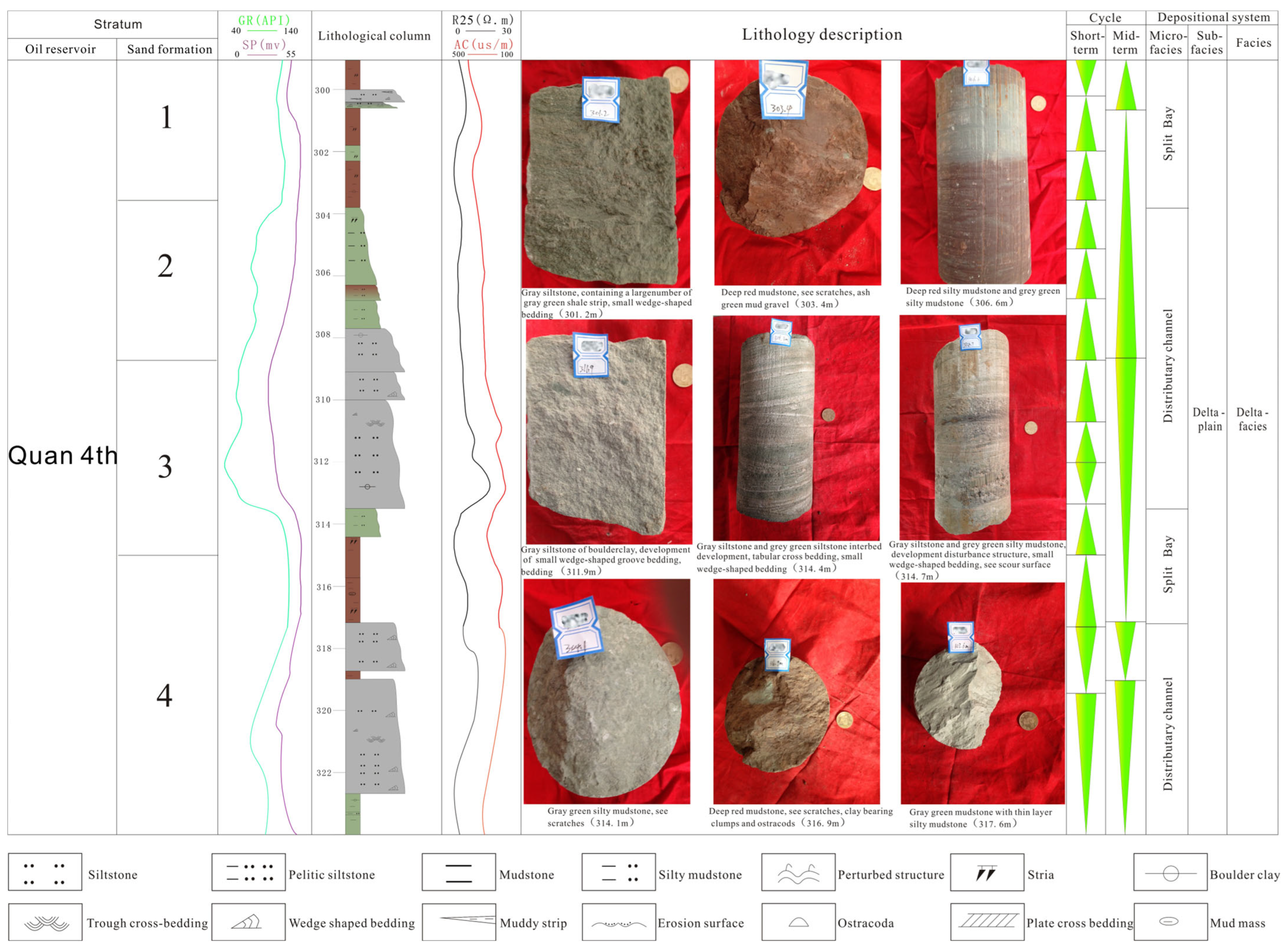
Each phase of the underwater distributary channel sand body was formed by eroding the underwater split bay, which rests upon mudstone. The mudstone predominantly exhibits dark red and celadon hues, displaying striations and containing clusters of muddy debris and ostracods. The alternating colors of the mudstone emerge intermittently and sometimes display abrupt contacts, collectively indicating that the sedimentary environment of the Quan 4 Member is characterized by semi-oxidation and semi-reduction. The lower section primarily consists of celadon and off-white siltstone, featuring tabular and wedge-shaped cross-bedding. Scour surfaces are present at the base of the underwater distributary channel’s sand body from one phase. The middle to upper section comprises celadon and dark-red mudstone, as well as celadon silty mudstone, which also exhibits striations. The uppermost section is composed of dark-red mudstone that includes ashen siltstone (Figure 3).

4.2. Two Provenance Systems

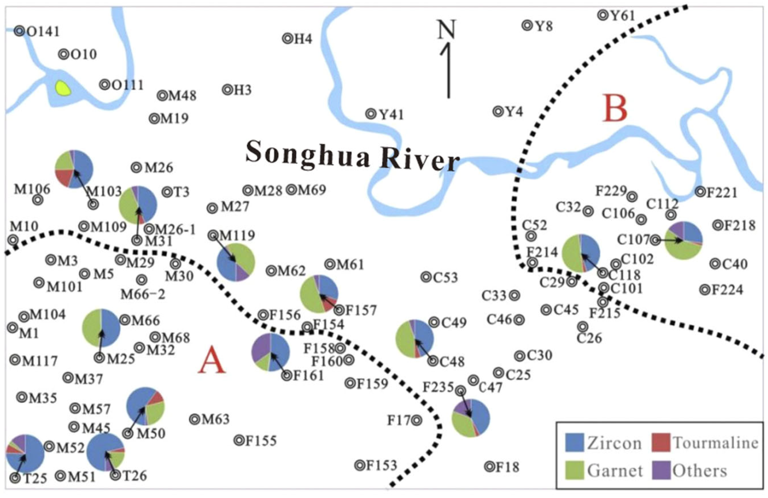
In the Mindong–Changchunling region, two distinct provenance systems that dictate the evolution of sedimentary sand body have been identified. These systems are discerned through the analysis of heavy mineral assemblages, sedimentary single factor maps, sedimentary grain size, and additional relevant factors (refer to Figure 4). The sampling method for heavy minerals is to collect fresh rock blocks using a drilling rig. The weight of each rock block should be no less than 1 kg. After crushing, representative samples are taken. The heavy mineral analysis method involves observing the microscopic morphology of minerals, determining the chemical composition of minerals by combining with energy dispersive spectroscopy (EDS), and accurately identifying minerals.

4.2.1. Heavy Mineral Assemblage

Upon examination of the compositions and content of heavy minerals, it is evident that these minerals predominantly originate from zircon (with acid magmatic rock as the primary parent rock) and garnet (with metamorphic rock as the parent rock). The magnetite content within the major heavy minerals from neutral and basic magmatic rocks is notably low. Authigenic minerals are primarily composed of pyrite, barite, and leucosphenite, among others. The statistical analysis of 83 terrigenous heavy mineral samples from 17 wells reveals the presence of two distinct categories of heavy mineral assemblages during the Quan 4 Member sedimentary period in the Mindong–Changchunling area. The characteristics of these assemblages are delineated as follows:
  • Category A Heavy Mineral Assemblage
This category of heavy mineral assemblage is primarily characterized by the presence of zircon, garnet, tourmaline, and so on. The average content of these heavy minerals is as follows: zircon at 70.3%, garnet at 16.22%, and tourmaline and other heavy minerals at less than 10%. Representative wells include Min 50, Tan 25, and Tan 26, among others.
  • Category B Heavy Mineral Assemblage
This category of heavy mineral assemblage is predominantly characterized by the presence of zircon, garnet, tourmaline, and allochite. The average content of these heavy minerals is as follows: zircon at 51.9%, garnet at 42%, and tourmaline and other heavy minerals at less than 7%. Representative wells include Chang 118 and Chang 107.

4.2.2. Maps of Sedimentary Single Factors

Upon examination of the sandstone thickness isoline and the sandstone percentage content map, it becomes evident that both the thickness and the percentage content diminish progressively from the southwestern regions encompassing wells Tan 25 and Tan 26 towards the northeastern areas of wells Min 61 and Min 27, as well as from the eastern zones of wells Chang 108 and Chang 112-1 towards the western zones of wells Chang 34 and Yuan 4. This observation aligns precisely with the outcomes of heavy mineral analysis. Furthermore, grain size analysis data exhibit a comparable pattern. It is therefore deduced that the study area is under the influence of the southwestern Changchun–Huaide depositional system and the eastern Yulin depositional system (Figure 5).

4.3. Characteristics of Sedimentary Sand Body

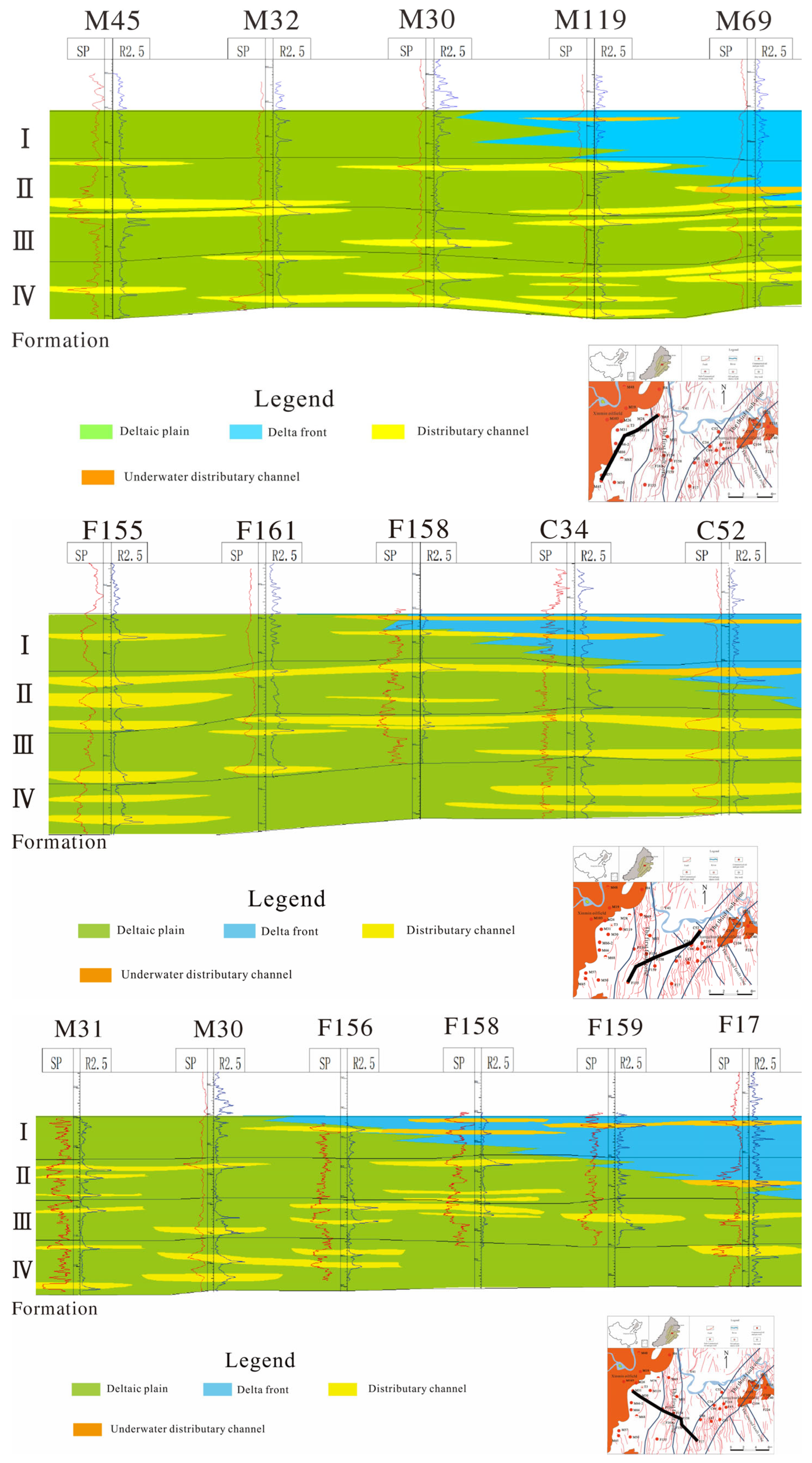
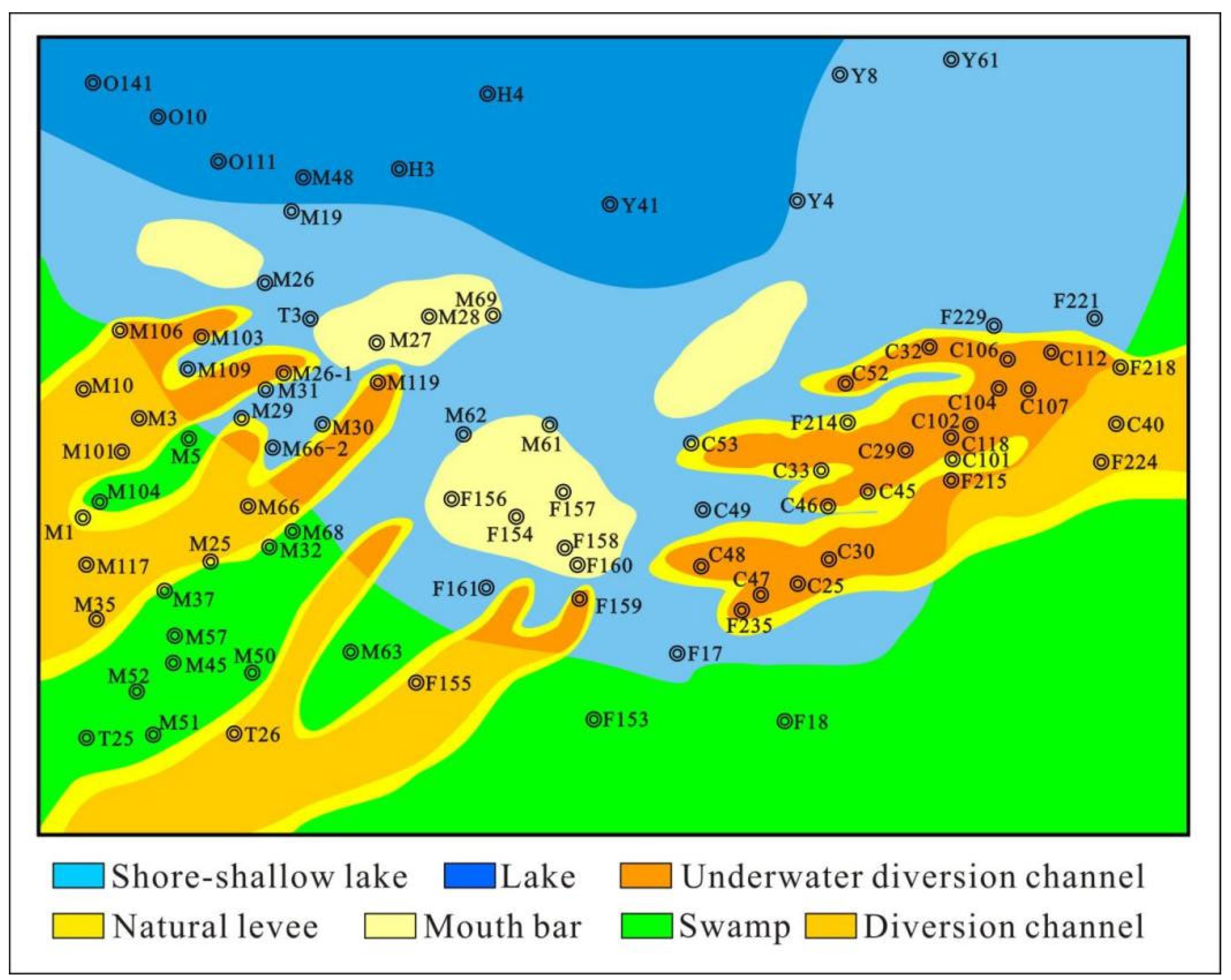
As depicted in Figure 6 and Figure 7, the distribution of the sand body within the Changchunling region is influenced by an eastern provenance, indicative of a near-source condition. Conversely, the sand body distribution in the Mindong area is governed by a southwest provenance, suggesting a far-source influence.
The sand bodies that extend in a southwest–northeast orientation exhibit distributary channel development within specific well areas, such as Min10, Min117, Fu155, Tan26, and others. Similarly, the underwater distributary channel sand bodies are observed in wells such as Fu159 and M119. Sand bodies aligned in an east–west direction also display distributary channel development in well areas, including Chang40 and Fu224, with underwater distributary channels identified in Chang 30, Chang 101, and Chang 29. These underwater distributary channel sand bodies are characterized by dendritic structures, possess a thickness ranging from 2 to 5 m, and have channel widths varying between 300 and 500 m. The development of the front channel mouth bar in the Well Fu160–Fu154–Min61 area is commonly attributed to the combined influence of eastern and southwestern source systems.

4.4. Reservoir Characteristics

4.4.1. Reservoir Petrological Characteristics

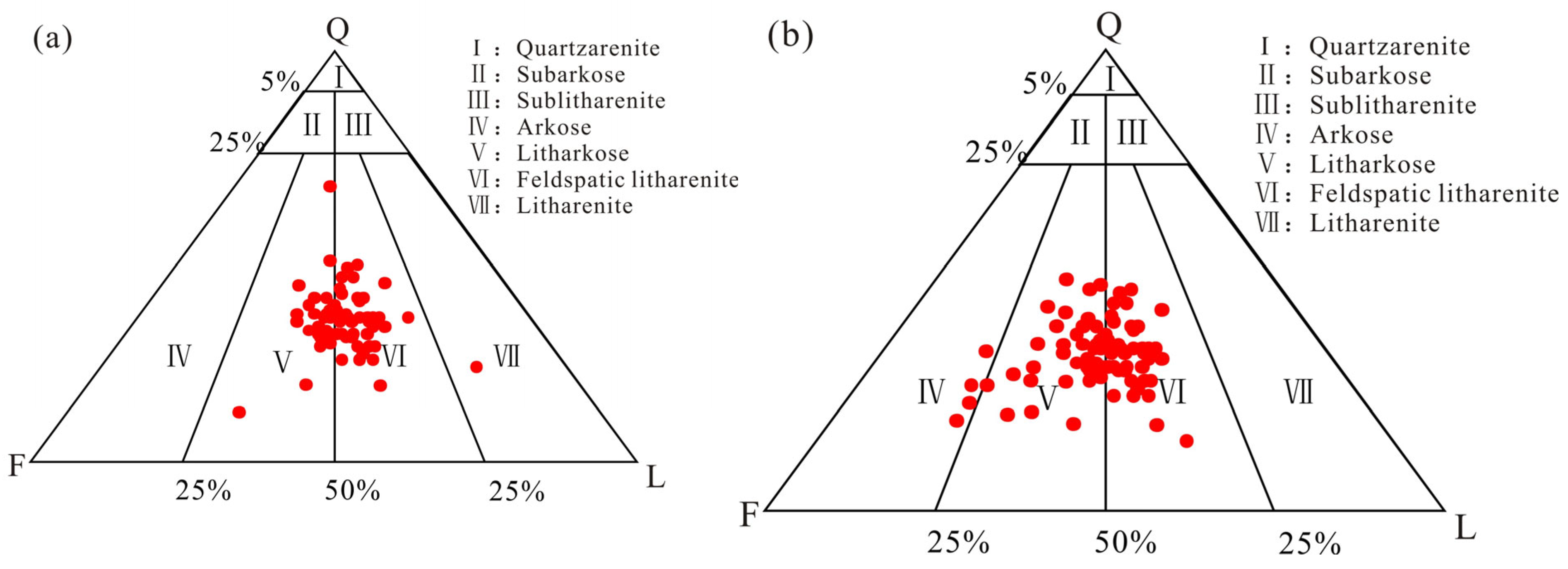
The lithological composition, grain size distribution, interstitial materials, and other characteristics exhibit significant variations between the Mindong and Changchunling regions. The Mindong region predominantly consists of fine sandstone and siltstone, with the former constituting 40 to 60 percent of the total, and the latter contributing 20 to 30 percent. The majority of the sandstones are medium-sorted and medium-subrounded, with the finer detrital grains displaying semi-angular and semi-round shapes. Grain-to-grain contact is predominantly point contact. The lithological assemblage primarily comprises feldspathic lithic and lithic arkose (Figure 8a), with an average framework composition of 34.3 percent quartz, 30.5 percent feldspar, and 35.2 percent rock fragments, and the latter is predominantly of volcanic origin. The average reservoir sandstone compositional maturity parameter Q/F + R is 0.52. The interstitial material content in most samples is relatively low, ranging from 5 to 10 percent, predominantly filling pores in matrix and cement forms, with the mud content (1 to 5 percent) primarily being a result of carbonate cementation.
The Changchunling region predominantly consists of fine sandstone, with lesser amounts of medium sandstone and siltstone. The fine sandstone content ranges from 60% to 90%. The majority of the sandstones exhibit medium to good sorting and medium subangular to subrounded grain shapes, and the finer detrital grains are primarily semi-angular and semi-round. Grain-to-grain contact is predominantly point contact. The primary rock types are feldspathic lithic and lithic arkose (Figure 8b), with an average framework composition of 31.87% quartz, 34.22% feldspar, and 33.9% rock fragments, and the latter is predominantly volcanic in origin. The average reservoir sandstone compositional maturity parameter Q/F + R is 0.46. The interstitial material content in most samples is relatively low, with an average of 13.55%. The matrix and cement predominantly fill the pores, with clayey interstitial material content reaching up to 10% (Table 2).

4.4.2. Reservoir Characteristics

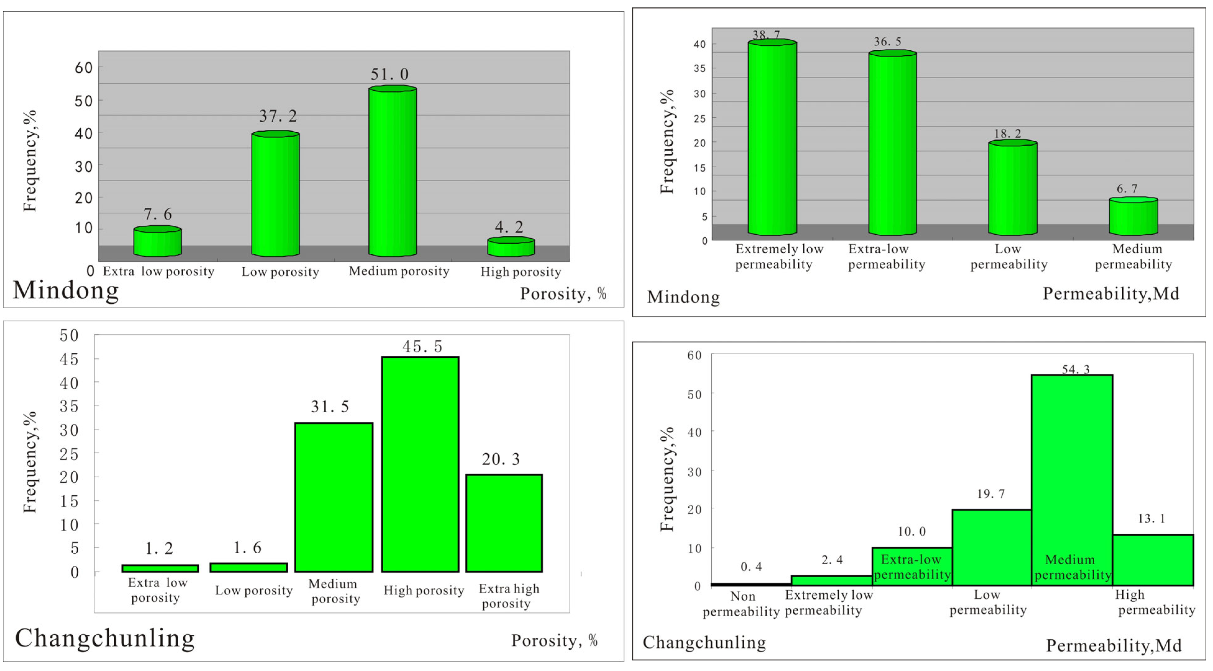
The reservoir characteristics exhibit significant disparities between the Changchunling and Mindong regions. Specifically, the Fuyu Oil Layer in the Mindong area possesses superior properties, characterized predominantly by medium-to-low porosity reservoirs with porosity values primarily ranging from 12% to 18%. The reservoirs are predominantly of low permeability, with a wide distribution of permeability values, where approximately 25% fall below 0.1 × 10⁻³ µm2, within the range of less than 0.1 × 10⁻³ µm2 to 500 × 10−3 µm2. It is thus concluded that the Fuyu Oil Layer of the Mindong area and the Quan 4 Member is characterized as a medium-to-low porosity and low permeability reservoir type.
In contrast, the Changchunling area’s porosity predominantly ranges from 15% to 35%, with a significant proportion of high porosity (15–25%) reservoirs. The sample distribution across various porosity categories—low and extra-low porosity (<10%), medium porosity (10–15%), high porosity (15–25%), and extra high porosity (>30%)—amounts to 2.8%, 31.5%, 45.5%, and 20.3%, respectively, out of a total of 941 samples. The findings indicate substantial variability in permeability within the Changchunling area, with a predominance of medium permeability (50–500 × 10−3 µm2) reservoirs. The sample distribution across permeability categories—ultra-low (0.1–10 × 10−3 µm2), extra-low (1–10 × 10−3 µm2), low (10–50 × 10−3 µm2), medium (50–500 × 10−3 µm2), and high (500–2000 × 10−3 µm2)—is 12.8%, 19.7%, 54.3%, and 13.1%, respectively, out of the same 941 samples (Figure 9).
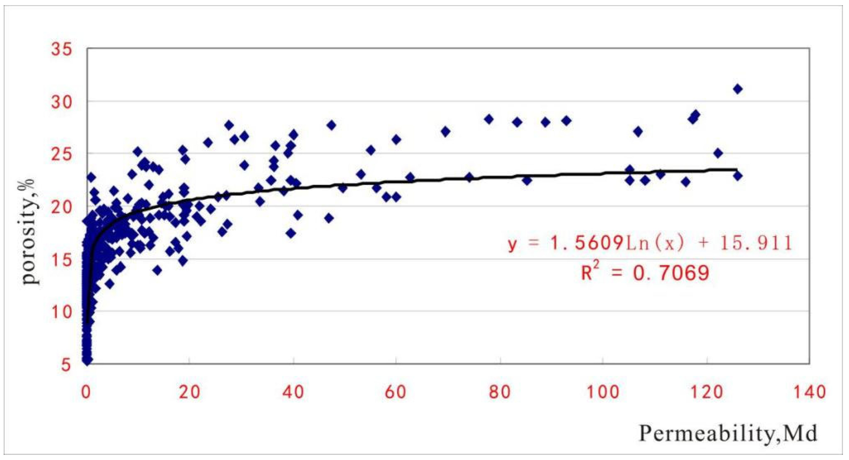
The cross plot indicates a strong correlation between reservoir porosity and permeability in the Mindong–Changchunling region. Permeability increases rapidly, experiencing a rapid increase when porosity exceeds 25%. Conversely, permeability remains at a lower level when porosity is below 25%. The primary reason for this phenomenon is that the amounts of pore-filling materials significantly affect porosity and serve as the main determinants of permeability (Figure 10). The plot reveals that, when porosity is relatively high, there is a scarcity of argillaceous fillings or carbonate cementation as interstitial materials. The absence of these pore-filling substances results in a notably improved permeability.

5. Discussion

5.1. Impact of Sedimentary and Diagenesis on Reservoir Quality

5.1.1. Sedimentary Environmental Factors

The grain size of the reservoir in the Mindong–Changchunling region is marginally fine, predominantly consisting of fine sandstone and siltstone, with medium sandstone being relatively scarce. The distributary channel and underwater distributary channel sand bodies primarily comprise fine sandstone and siltstone, with minor occurrences of siltstone and medium sandstone. This indicates that medium sandstone exhibits the optimal reservoir characteristics; however, drilling data reveal a scarcity of this type in the region. Fine sandstone constitutes the principal layer and demonstrates superior reservoir properties. The grain size of the distributary channel reservoir is marginally coarser, and its reservoir properties are superior to those of the underwater distributary channel facies (refer to Table 3). Mudstone predominantly exists within the inter-channel facies, with a minor development of siltstone that possesses inferior reservoir properties. Regrettably, the reservoir properties of the inter-channel facies are superior to those of the distributary channel facies. The morphology and scale of the reservoir are dictated by the high sand-body thickness ratio regions of the distributary channel and underwater distributary channel. Nevertheless, the slightly finer grain size of the reservoir in this area results in suboptimal reservoir properties for the mouth bar sand body.

5.1.2. Influence of Diagenesis on Reservoir

The diagenetic processes of the depositional system and subsequent structural evolution exhibit distinct characteristics in the Changchunling area. The reservoirs in this region predominantly fall within the early to middle stages of diagenesis. Despite the reservoirs being buried at depths ranging from 100 to 300 m, they are primarily characterized by porous cementation and point-to-point grain contacts, suggesting a relatively early diagenetic phase. However, scanning electron microscopy (SEM) data reveal the presence of quartz grains exhibiting secondary enlargement of II–III grade, and in some samples, point-line grain contacts are observed, indicating a progression into the middle stage of early diagenesis. Furthermore, the structural history indicates that the reservoirs in Changchunling have undergone deep burial, as evidenced by the Fuyu Oil Layer, which reached a maximum depth of over 1500 m. The area subsequently experienced significant erosion during the late stage of basin evolution, with the Mingshui formation sedimentary period witnessing an erosion of over 1000 m [42,43].
At the termination of the Mingshui formation’s depositional phase, fluid compartment boundaries were established by the lower boundary of the Pacific plate and rapid subduction [44,45]. Analysis of the Qingshankou 1 Member mudstone organic matter in the region indicates a vitrinite reflection (R0) of 0.5–0.69% and a pyrolysis peak temperature (max) of 424–456 °C, suggesting that the organic evolution has entered a low maturity stage. This suggests that the diagenetic stage of the Changchunling reservoir is within the middle phase of diagenesis [46]. Reservoir depths in the Mindong area range from 600 to 1200 m, characterized by strong cementation, indicating a medium phase of the middle diagenetic stage.
The high mud content in Changchunling is influenced by proximity to the source, yet the reservoir properties are favorable due to shallow burial depth, minimal compaction, and subsequent dissolution by surface waters. Reservoirs related to burial dissolution are predominantly located in areas with structural fractures, fault zones, and hydrocarbon migration pathways, resulting in the formation of high-quality reservoirs in this region. In contrast, the Mindong area experiences strong compaction due to the greater depth of burial, but the reservoir properties remain favorable due to the lower mud content resulting from a more distant source and organic acid dissolution, leading to the development of another type of high-quality reservoir.
(1)
Compaction
Extensive thin section observations indicate that the sandstones in the Mindong–Changchunling area are primarily characterized by point contacts and exhibit weak compaction. The reservoirs in Changchunling are buried at depths ranging from 100 to 300 m, while those in Mindong are buried at depths ranging from 600 to 1200 m. Samples from Changchunling are relatively loose, with the reservoir space dominated by primary intergranular pores and a few secondary dissolution pores, displaying good connectivity. A clear trend is observed in the relationship between porosity and depth, where the porosity of the deeper buried areas is significantly lower than that of the Changchunling area. This indicates that compaction is a primary factor contributing to the reduction in porosity.
Compaction induces the reorganization of particles and the densification of the reservoir [47]. The compaction of the reservoir causes the distance between clastic particles to diminish progressively, thereby increasing the density of the reservoir. This process leads to the emergence of line contacts between some particles, which adversely affects the physical properties of the reservoir. The findings of these studies indicate that the size of the pore-throat is a critical factor that influences both the flow characteristics and storage potential of the rock [48]. The Mindong area is characterized by high contents of feldspar and lithic materials, which are prone to compaction and result in the narrowing of pore throats, leading to a rapid decline in permeability relative to porosity. This phenomenon accounts for the low permeability observed in the Mindong area. However, the rate at which porosity decreases with depth is relatively slow, suggesting that the changes in porosity are influenced by additional diagenetic processes (Figure 11).
(2)
Cementation
The primary forms of cementation in the Mindong area include carbonate cementation, clay mineral cementation, and quartz secondary enlargement. Carbonate cementation is prevalent in this region, with an average content of approximately 10%. Core data analysis reveals a negative correlation between porosity and permeability and the content of carbonate cements. This suggests that carbonate cements are detrimental to the development of pore spaces. Clay minerals, predominantly illite, chlorite, and illite/montmorillonite mixed-layer varieties, are present in low concentrations. These clay minerals occur in two primary modes within clastic grains, as pore-lining and pore-filling. The presence of clay minerals significantly impacts the porosity and permeability of the reservoir, with illite in particular markedly reducing reservoir permeability. The secondary enlargement of grade I-II quartz in the Mindong area diminishes the pore volume and reduces reservoir permeability. Statistics indicate that siliceous cementation can reduce initial porosity by approximately 2%. To enhance the long-term stability of reservoirs impacted by early- to mid-stage diagenetic cementation, especially in the context of well construction and sealing integrity, the application of optimized multi-component plugging systems, as proposed by Vytyaz et al. (2024) [49], could prove effective. Their work shows that cement compositions modified with calcium sulfoferrites significantly improve bonding and early strength, which is particularly important for formations undergoing diagenetic alteration [49].
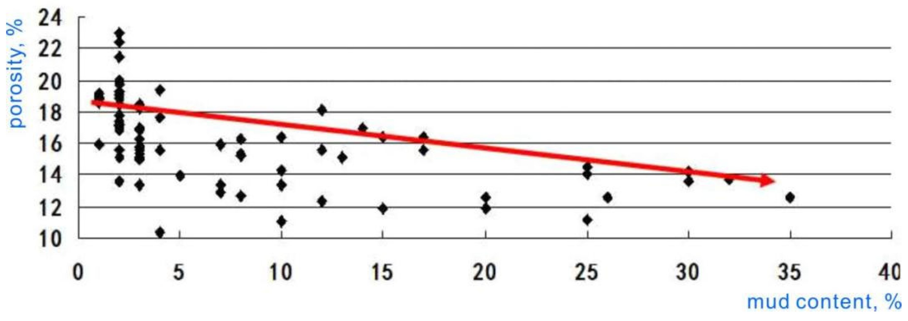
The primary cements in the Changchunling region comprise clay mineral cementation, carbonate cementation, and quartz secondary enlargement. The illite/montmorillonite mixed-layer content is notably high, constituting an average of 5.2%, while chlorite comprises an average of 3.4%. Conversely, the content of kaolinite and illite is significantly low. A negative correlation exists between clay mineral content and porosity (refer to Figure 12). The carbonate content is also low, with an average of approximately 4%, leading to a reduction in porosity to a certain extent. The secondary enlargement of quartz grades I-III in the Changchunling area can diminish the initial porosity by approximately 5%.
(3)
Dissolution
Feldspar dissolution predominates in the Mindong area, which is likely associated with the expulsion of substantial organic acids influenced by deep burial. On one hand, hydrocarbon influx preserves the primary pores to the greatest extent by inhibiting various original inorganic diagenetic reactions within the sandstone pores, such as quartz overgrowth, the formation of authigenic clay minerals, and the sedimentation of carbonate cementation, among others. On the other hand, the feldspar and other minerals undergo dissolution due to changes in the geochemical environment of the pore water. The acid released from the transformation of hydrocarbon-generating minerals can dissolve feldspar [50], resulting in the extensive development of secondary pores.
Conversely, the primary dissolution in the Changchunling area is attributed to feldspar and carbonate dissolution.
Similar to the Amguid Messaoud field in Algeria, where fault systems and structural features play a key role in reservoir fracturing and seismic facies distribution (Mahmoud, 2023) [51], the Mindong–Changchunling area exhibits tectonically controlled zones of enhanced reservoir quality. Integrating sedimentological interpretation with structural framework, as Mahmoud demonstrated using seismic and statistical facies classification, could further refine reservoir prediction models in this region (Figure 13).

5.2. Advantageous Reservoir

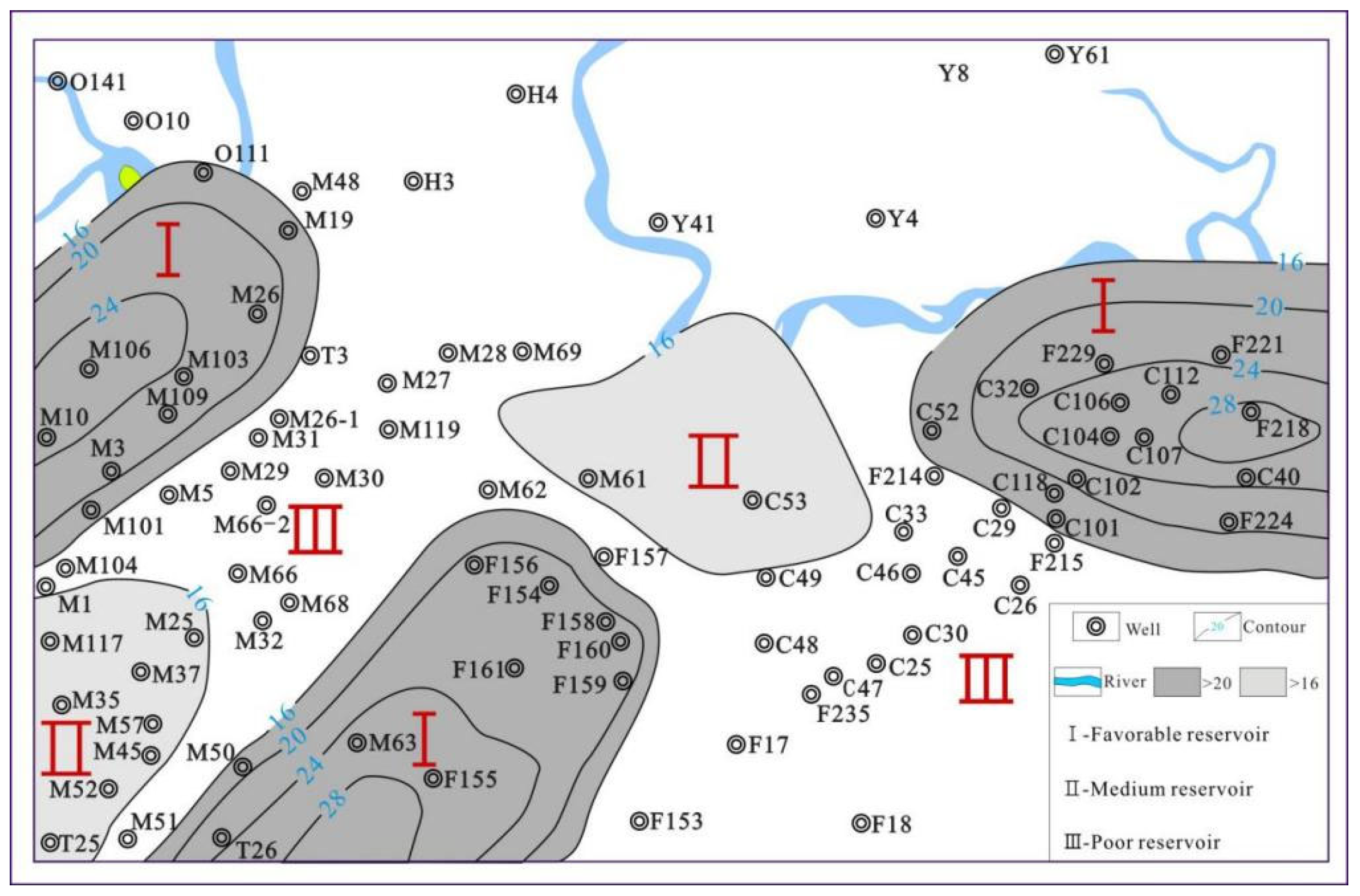
Three advantageous reservoir zones with distinct origins, namely the Chang107–Chang104–Chang52 well area, the Fu155–Fu161–Fu157 well area, and the Min103–Min31 well area, have been formed due to variations in sedimentation and diagenesis in the Mindong–Changchunling area (Figure 14). To improve the prediction accuracy of reservoir properties in heterogeneous systems such as the Mindong–Changchunling area, comparative approaches to seismic interpretation, including traditional pre-stack inversion and emerging neural learning techniques, can be effectively applied. As demonstrated by Dzhangirov et al. (2024) [52], machine learning methods offer improved resolution in structurally complex fields with limited seismic resolution, making them a useful complement to sedimentological and diagenetic analysis in guiding development strategies.

5.2.1. Chang107–Chang104–Chang 52 Well Area

The Chang107–Chang104–Chang52 well area is controlled by the eastern provenance, characterized by coarse lithology and good reservoir properties. The average porosity is 26.4%, ranging from 19.4% to 30.8%, and the average permeability is 63.7 × 10⁻³ µm2, ranging from 3.5 × 10⁻³ µm2 to 122.1 × 10⁻³ µm2.
In this area, the types of advantageous diagenetic facies include weakly compacted facies, weak carbonate cementation facies, and strong dissolution facies. In contrast, the disadvantageous diagenetic facies are predominantly strong clay cement facies. Due to proximity to the second and third fault intensive zones, the advantageous reservoirs are formed by the eluviation of feldspar and carbonate cements by groundwater.

5.2.2. Fu155–Fu161–Fu157 Well Area

The Fu155–Fu161–Fu157 well area is controlled by the southwestern Changchun–Huaide depositional system, characterized by fine lithology. The average porosity is 18.6%, ranging from 6% to 22.3%, and the average permeability is 24.9 × 10⁻³ µm2, ranging from 0.1 × 10⁻³ µm2 to 116 × 10−3 µm2.
In this area, the types of advantageous diagenetic facies include weak clay cementation and strong dissolution facies. Conversely, the types of disadvantageous diagenetic facies include relatively strong compaction facies and relatively strong carbonate cementation. Due to proximity to the first fault intensive zones and the migration of organic acids along these zones, the advantageous reservoir has been formed, largely through the dissolution of feldspar [53].

5.2.3. Min103–Min31 Well Area

The Min103–Min31 well area is controlled by the southwestern Changchun–Huaide depositional system. The average porosity value is 15.7%, ranging from 13.3% to 23.9%, while the average permeability value is 18.1 × 10⁻³ µm2, ranging from 1 × 10⁻³ µm2 to 30.1 × 10⁻³ µm2.
In this area, the types of advantageous diagenetic facies include weak clay cementation and strong dissolution facies. Conversely, the types of disadvantageous diagenetic facies include relatively strong compaction facies and relatively strong carbonate cementation. Due to its proximity to the Sanzhao depression and the migration of organic acid along fault zones, fluids rich in organic acid may be responsible for feldspar alteration and subsequent kaolinite precipitation [53], leading to the formation of an advantageous reservoir characterized by extensive feldspar dissolution.

6. Conclusions

The Mindong–Changchunling area is primarily developed in shallow water delta facies. The underwater distributary channel sand body serves as the main reservoir. The following two primary depositional systems have been developed: the Southwestern Changchun–Huaide depositional system and the eastern provenance Yulin depositional system. The distribution of the sand body in the Changchunling area is controlled by the eastern provenance (near-source), while the distribution of the sand body in the Mindong area is influenced by the southwestern provenance (far-source).
The Mindong area predominantly consists of fine sandstone and siltstone, with rock types mainly comprising feldspathic lithic and lithic arkose. The average reservoir sandstone compositional maturity parameter Q/F + R is 0.52. In contrast, the Changchunling area is primarily composed of fine sandstone, with similar rock types, including feldspathic lithic and lithic arkose. The average reservoir sandstone compositional maturity parameter Q/F + R is 0.46, which is lower than that of the Mindong area.
The distribution of high-quality reservoirs is limited due to the significant differences in provenance, sedimentation, diagenesis, and other factors in the Mindong–Changchunling area. The distribution of the sand body in the Changchunling area is controlled by the eastern provenance (near-source). The reservoir properties of the sand body are affected by the poor sorting and high mud content of the near-source delta sand body. However, the reservoir properties of the sand body are enhanced by late uplift and the dissolution eluviations of surface water. The distribution of the sand body in the Mindong area is controlled by the southwestern provenance (far-source). Additionally, the far-source delta sand body is characterized by good sorting and high mud content, which primarily decreases the reservoir properties of the sand body due to carbonate cementation. In the early to middle diagenetic stage, the feldspar is dissolved by organic acid, which improves the reservoir properties of the sand body.
The following three advantageous reservoir zones with distinct genetic characteristics have been formed due to differences in sedimentation and diagenesis in the Mindong–Changchunling area: the Chang107–Chang104–Chang52 well area, the Fu155–Fu161–Fu157 well area, and the Min103–Min31 well area.

Author Contributions

Methodology, J.T.; Validation, S.D.; Formal analysis, P.L.; Investigation, Z.L.; Supervision, W.L. All authors have read and agreed to the published version of the manuscript.

Funding

The research in this thesis is supported by the National Natural Science Foundation Project (grants 41262006 and 41662010). The PetroChina Jilin Oilfield Company is represented by its extensive data on Oil and Geology. The research of this thesis was supported by the Key Research and Development Task Special Project of Xinjiang Uygur Autonomous Region (Project No. 2024B01013-3).

Data Availability Statement

The original contributions presented in this study are included in the article. Further inquiries can be directed to the corresponding author.

Acknowledgments

I extend my deepest gratitude to General Geologists Tang Zhenxing and Song Libin from the Exploration and Development Research Institute of PetroChina Jilin Oilfield Company for providing valuable suggestions for this study.

Conflicts of Interest

Authors Wenjie Li, Zhengkai Liao, and Peng Lai are employed by Xinjiang Yaxin Coalbed Methane Resource Technology Research Co., Ltd. The authors declare that this study received funding from PetroChina Jilin Oilfield Company. The funder was not involved in the study design, collection, analysis, interpretation of data, the writing of this article or the decision to submit it for publication. The remaining authors declare that this research was conducted without any commercial or financial relationships that may be considered potential conflicts of interest.

References

  1. Merriam, D.E. Symposium on Cyclic Sedimentation. Kans. Kans. Geol. Surv. Bull. 1964, 169, 1–200. [Google Scholar] [CrossRef]
  2. Wang, Y.; Yan, M.; Lang, Y.; Fu, G.; Li, X. Re-determining source faults of the Upper Cretaceous Putaohua oil layer in Sanzhao sag of Songliao Basin, NE China. Petrol. Explor. Develop. 2015, 42, 802–809. [Google Scholar] [CrossRef]
  3. Seifert, W.K.; Moldowan, J.M.; Jones, R.W. Application of biological marker chemistry to petroleum exploration. In Proceedings of the Tenth World Petroleum Congress; Heyden & Son, Inc.: Philadelphia, PA, USA, 1980; pp. 425–440. [Google Scholar] [CrossRef]
  4. Zhao, B.; Wang, C.S.; Wang, X.F. Late Cretaceous (Campanian) Provenance change in the Songliao Basin, NE China: Evidence from detrital zircon U-Pb ages from the Yaojia and Nenjiang Formations. Palaeogeogr. Palaeoclimatol. Palaeoecol. 2013, 385, 83–94. [Google Scholar] [CrossRef]
  5. Chen, F.; Lu, S.; Liu, H.; Huang, W.; Xu, Y.; Wu, Z. A Discuss on Hydrocarbon Accumulation in Changchunling Anticline Belt, Northern Songliao Basin. Geol. Rev. 2011, 57, 379–386, (In Chinese with English abstract). [Google Scholar] [CrossRef]
  6. Wang, L. Characteristics of Hydrocarbon Accumulation of Fuyu Reservoir in Chaoyanggou-Changchunling Area. Xinjiang Pet. Geol. 2012, 33, 456–458, (In Chinese with English abstract). [Google Scholar]
  7. Huang, W.; Wu, H.; Shi, L.; Wang, S.; Wang, Z. Oil and gas source and reservoir characteristic of Fuyu Reservoir of Chaochang area in north Songliao Basin. J. Cent. South Univ. (Sci. Technol.) 2012, 43, 238–248, (In Chinese with English abstract). [Google Scholar]
  8. Wang, Y. Formation and distributon of the abnormal pressures in 3Chaoyanggou terrace-Changchunling anticlinal belts. Pet. Geol. Oilfield Dev. Daqing 2014, 33, 29–35, (In Chinese with English abstract). [Google Scholar] [CrossRef]
  9. Shi, L.; Ma, C.; Wang, Z.; Zhang, Y. Oil and gas accumulating conditions and its main controlling factors of Fuyu reservoirs in ChaoChang area. Pet. Geol. Oilfield Dev. Daqing 2014, 33, 1–6, (In Chinese with English abstract). [Google Scholar] [CrossRef]
  10. Vail, P.R. Stratigraphy Interpretation Using Sequence Stratigraph. Partl: Stratigraphy Interpretation Procedure. AAPG Stud. Seology 1987, 27, 1–10. [Google Scholar]
  11. Lima, R.D.; De Ros, L.F. The role of depositional setting and diagenesis on the reservoir quality of Late Devonian sandstones from the Solimoes Basin, Brazilian Amazonia. Mar. Pet. Geol. 2002, 19, 1047–1071. [Google Scholar] [CrossRef]
  12. Zhang, J.L.; Qin, L.J.; Zhang, Z.J. Depositional facies, diagenesis and their impact on the reservoir quality of Silurian sandstones from Tazhong area in central Tarim Basin, western China. J. Asian Earth Sci. 2008, 33, 42–60. [Google Scholar] [CrossRef]
  13. El-Ghali, M.A.K.; Morad, S.; Mansurbeg, H.; Caja, M.A.; Ajdanlijsky, G.; Ogle, N.; AlAasm, I.; Sirat, M. Distribution of diagenetic alterations within depositional facies and sequence stratigraphic framework of fluvial sandstones: Evidence from the Petrohan Terrigenous Group, Lower Triassic, NW Bulgaria. Mar. Pet. Geol. 2009, 26, 1212–1227. [Google Scholar] [CrossRef]
  14. Schmid, S.; Worden, R.H.; Fisher, Q.J. Diagenesis and reservoir quality of the Sherwood Sandstone (Triassic), Corrib field, Slyne Basin, west of Ireland. Mar. Pet. Geol. 2004, 21, 299–315. [Google Scholar] [CrossRef]
  15. Dutton, S.P.; Loucks, R.G. Diagenetic controls on evolution of porosity and permeability in lower Tertiary Wilcox sandstones from shallow to ultradeep (200–6700 m) burial, Gulf of Mexico Basin, U.S.A. Mar. Pet. Geol. 2010, 27, 69–81. [Google Scholar] [CrossRef]
  16. Morad, S.; Al-Ramadan, K.; Ketzer, J.M.; De Ros, L.F. The impact of diagenesis on the heterogeneity of sandstone reservoirs: A review of the role of depositional facies and sequence stratigraphy. AAPG Bull. 2010, 94, 1267–1309. [Google Scholar] [CrossRef]
  17. Feng, J.L.; Cao, J.; Hu, K.; Peng, X.Q.; Chen, Y.; Wang, Y.F.; Wang, M. Dissolution and its impacts on reservoir formation in moderately to deeply buried strata of mixed siliciclastic-carbonate sediments, northwestern Qaidam Basin, northwest China. Mar. Pet. Geol. 2013, 39, 124–137. [Google Scholar] [CrossRef]
  18. Shu, P.; Ding, R.; Qu, Y.; Ji, X. Lithologic and lithofacies patterns of volcanic reservoirs in Xushen Gas Field. Nat. Gas Ind. 2007, 27, 23–28. Available online: https://www.sciengine.com/doi/pdf/7053D59BA0B24EE5847B9450169E8996 (accessed on 10 August 2025).
  19. Ajdukiewicz, J.M.; Larese, R. How clay grain coats inhibit quartz cement and preserve porosity in deeply buried sandstones: Observations and experiments. AAPG Bull. 2011, 96, 2091–2119. [Google Scholar] [CrossRef]
  20. Anjos, S.M.C.; DeRos, L.; Silva, C.M.A. Chlorite authigenesis and porosity preservation in the Upper Cretaceous marine sandstones of the Santos Basin, offshore eastern Brazil, Int. Assoc. Sedimentology 2003, 34, 291–316. [Google Scholar] [CrossRef]
  21. French, M.W.; Worden, R.H.; Mariani, E. Microcrystalline quartz generation and the preservation of porosity in sandstones: Evidence from the Upper Cretaceous of the Subhercynian basin, Germany. J. Sediment. Res. 2012, 82, 422–434. [Google Scholar] [CrossRef]
  22. Bloch, S.; Lander, R.H.; Bonnell, L. Anomalously high porosity and permeability in deeply buried sandstone reservoirs: Origin and predictability. AAPG Bull. 2002, 86, 301–328. [Google Scholar] [CrossRef]
  23. Ding, X.; Yang, P.; Han, M.; Chen, Y.; Zhang, S.; Zhang, S.; Liu, X.; Gong, Y.; Nechval, A.M. Characteristics of gas accumulation in a less efficient tight-gas reservoir, He 8 interval, Sulige gas field, Ordos Basin, China. Russ. Geol. Geophys. 2016, 57, 1064–1077. [Google Scholar] [CrossRef]
  24. Wang, Y.Z.; Shi, S.M. Sedimentary characteristics of Fuyu oil layer in Lingnan block of Changchun. China Manganese Ind. 2018, 36, 94–97. [Google Scholar] [CrossRef]
  25. Zhu, H.L.; Zhan, S.F.; Liu, X.W.; Xie, Z.R. Study on reservoir characteristics of Lingnan area in Changchun. China Manganese Ind. 2019, 37, 64–67. [Google Scholar] [CrossRef]
  26. Liu, Z.J.; Wang, D.P.; Liu, L.; Liu, W.S.; Wang, P.J.; Du, X.D.; Yang, G. Sedimentary Characteristics of the Cretaceous Songliao Basin. Acta Geol. Sin. 1993, 6, 167–180. [Google Scholar] [CrossRef]
  27. Zhang, L.; Wang, Y.M.; Li, S.Q.; Han, J.H.; Zhang, X.T.; Zhu, Y.H.; Wang, G.Y.; Yang, T. High-resolution sequence stratigraphic characteristic and favorable hydrocarbon accumulation prediction of Sifangtai to Mingshui formation in the north of Songliao Basin. J. Cent. South Univ. (Sci. Technol.) 2009, 40, 1679–1688. [Google Scholar] [CrossRef]
  28. Cheng, R.; Wang, G.; Wang, P.; Gao, Y. Uppermost Cretaceous sediments: Sedimentary microfacies and sedimentary environment evolution of Sifangtai Formation and Mingshui Formation in SKIn. Earth Sci. Front. 2009, 16, 85–95, (In Chinese with English abstract). [Google Scholar] [CrossRef]
  29. Feng, Z.Q.; Jia, C.Z.; Xie, X.N.; Zhang, S.; Feng, Z.H.; Timothy, A.C. Tectonostratigraphic units and stratigraphic sequences of the nonmarine Songliao Basin, northeast China. Basin Res. 2010, 22, 79–95. [Google Scholar] [CrossRef]
  30. Zeng, H.; Zhu, X.; Zhu, R.; Zhang, Q. Seismic prediction of sandstone diagenetic facies: Applied to Cretaceous Qingshankou Formation in Qijia Depression, Songliao Basin, East China. Pet. Explor. Dev. 2013, 40, 287–295. [Google Scholar] [CrossRef]
  31. Li, Z.D.; Wang, D.J.; Zhang, H.X.; Yin, Y.L.; Zhao, F.Q.; Xu, L.; Cheng, P.; Liu, Y. Sedimentary characteristics of typical fluvial facies in the Cretaceous Quantou Formation in southeast uplift of southern Songliao Basin. Oil Gas Geol. 2015, 36, 621–629, (In Chinese with English abstract). [Google Scholar] [CrossRef]
  32. Zhu, X.; Zeng, H.; Li, S.; Dong, Y.; Zhu, S.; Zhao, D.; Huang, W. Sedimentary characteristics and seismic geomorphologic responses of a shallow-water delta in the Qingshankou Formation from the Songliao Basin, China. Mar. Pet. Geol. 2017, 79, 131–148. [Google Scholar] [CrossRef]
  33. Donaldson, A.C. Pennsylvanian sedimentation of central Appalachians, special papers. Geol. Soc. Am. 1974, 148, 47–48. [Google Scholar] [CrossRef]
  34. Wei, W.; Zhang, C.; Zhang, S.; Wu, C.; Yang, K. Study on the Cretaceous turbidite and reservoir features in the Qingshankou Formation in northern Songliao Basin, NE China. Mar. Pet. Geol. 2017, 78, 797–806. [Google Scholar] [CrossRef]
  35. Chamberlain, C.P.; Wan, X.; Graham, S.A.; Carroll, A.R.; Doebbert, A.C.; Sageman, B.B.; Blisniuk, P.; Kent-Corson, M.L.; Zhou, W.; Wang, C. Stable isotopic evidence for climate and basin evolution of the Late Cretaceous Songliao basin, China. Palaeogeogr. Palaeoclimatol. Palaeoecol. 2013, 385, 106–124. [Google Scholar] [CrossRef]
  36. Feng, C.; Bao, Z.; Yang, L.; Si, X.; Xu, G.; Han, X. Reservoir architecture and remaining oil distribution of deltaic front underwater distributary channel. Pet. Explor. Dev. 2014, 41, 358–364. [Google Scholar] [CrossRef]
  37. Pan, S.X.; Wei, P.S.; Wang, T.Q.; Liang, S.J.; Zhao, Z.K.; Zhao, Z.Y.; Tang, Z.X.; Cui, H.N. Discovery of Easter Provenance in Songliao Basic and Its Implications on Petroleum Geology. Nat. Gas Geosci. 2011, 22, 1021–1027, (In Chinese with English abstract). [Google Scholar]
  38. Sun, Y.; Ma, S.; Cong, L.; Zhao, H.; Yu, L.; Fu, X. Study on Depositional Characteristics and Model of Fuyu Oil Layer in the Southern Fuxin Uplift of Songliao Basin. Acta Sedimentol. Sin. 2012, 30, 706–715, (In Chinese with English abstract). [Google Scholar] [CrossRef]
  39. Feng, C.; Bao, Z.; Dai, C.; Zhang, Z. Superimposition patterns of underwater distributary channel sands in deltaic front and its control on remaining oil distribution: A case study from K1q4 in J19 block, Fuyu oilfield. Oil Gas Geol. 2015, 36, 128–135, (In Chinese with English abstract). [Google Scholar] [CrossRef]
  40. Horne, J.C.; Ferm, J.C.; Caruccio, F.T.; Baganz, B.P. Depositional models in coal exploration and mine planning in appalachian region. AAPG Bull. 1976, 62, 2379–2411. [Google Scholar] [CrossRef]
  41. Zhu, X.M.; Liu, Y.; Fang, Q.; Li, Y.; Liu, Y.Y.; Wang, R.; Song, J.; Liu, S.Q.; Cao, H.T.; Liu, X.N. Formation and sedimentary model of shallow delta in largescale lake.example from cretaceous Quantou Formation in Sanzhao Sag, Songliao Basin. Earth Sci. Front. 2012, 19, 89–99, (In Chinese with English abstract). [Google Scholar]
  42. Lefebvre, C.; Barnhoorn, A.; van Hinsbergen, D.J.J.; Kaymakci, N.; Vissers, R.L.M. Late Cretaceous extensional denudation along a marble detachment fault zone in the Kirşehir massif near Kaman, central Turkey. J. Struct. Geol. 2011, 33, 1220–1236. [Google Scholar] [CrossRef]
  43. Xi, K.; Cao, Y.; Jahren, J.; Zhu, R.; Bjørlykke, K.; Girma Haile, B.; Zheng, L.; Hellevang, H. Diagenesis and reservoir quality of the Lower Cretaceous Quantou Formation tight sandstones in the southern Songliao Basin, China. Sediment. Geol. 2015, 330, 90–107. [Google Scholar] [CrossRef]
  44. Engebretson, D.C.; Cox, A.; Gordan, R.G. Relative motions between oceanic and continental. Soc. Am. Spec. Pap. 1985, 206, 1–60. [Google Scholar] [CrossRef]
  45. Maruyama, S.; Tetsuzo, S. Orogeny and relative plate motions; example of the Japanese islands. Tectonophysics 1986, 127, 305–329. [Google Scholar] [CrossRef]
  46. Li, D.; Dong, C.; Lin, C.; Ren, L.; Jiang, T.; Tang, Z. Control factors on tight sandstone reservoirs below source rocks in the Rangzijing slope zone of southern Songliao Basin, East China. Pet. Explor. Dev. 2013, 40, 742–750. [Google Scholar] [CrossRef]
  47. Houseknecht, D.W. Assessing the relative importance of compaction processes and cementation to reduction of porosity in sandstones. AAPG Bull. 1987, 71, 633–642. [Google Scholar] [CrossRef]
  48. Wimmers, K.; Koehrer, B. Integration of sedimentology, petrophysics and rock typing as key to understanding a tight gas reservoir. Oil Gas Eur. Mag. 2014, 40, 196–200. [Google Scholar]
  49. Vytyaz, O.; Chernova, O.; Stavychnyi, Y.; Martyniuk, R.; Ziaja, J. Increasing the reliability of oil and gas well fastening with polycomponent plugging systems. Min. Miner. Depos. 2024, 18, 82–93. [Google Scholar] [CrossRef]
  50. Schmidt, V.; Mc Donald, D.A. The role of secondary porosity in the course of sandstone diagenesis. SEPM Spec. Publ. 1979, 26, 175–207. [Google Scholar] [CrossRef]
  51. Mahmoud, H. Automatic characterization and quantitative analysis of seismic facies in naturally fractured reservoir: Case study of Amguid Messaoud field, Algeria. Min. Miner. Depos. 2023, 17, 42–48. [Google Scholar] [CrossRef]
  52. Dzhangirov, A.N.; Bekbaltina, G.K.; Umirova, G.K.; Temirkhanova, R.G.; Abdoldina, F.N. Comparative analyzing the technology of predicting reservoir properties according to seismic data based on linear and nonlinear prediction algorithms. Eng. J. Satbayev Univ. 2024, 146, 54–60. [Google Scholar] [CrossRef]
  53. Faerseth, R.B. Interaction of Permo-Triassic and Jurassic extensional fault-blocks during the development of the northern North Sea. J. Geol. Soc. Lond. 1996, 153, 931–944. [Google Scholar] [CrossRef]
Figure 2. Cumulative grain-size distribution curve of the main reservoir stratum. (The left figure is the Mindong area, and the right figure is the Changchunling area).
Processes 13 02623 g002
Figure 3. Sedimentary succession diagram of the Fuyu Oil Layer in Fu 235 well Quan 4 Member in the Mingdong–Changchun range area.
Processes 13 02623 g003
Figure 4. Heavy mineral distribution of the Quan 4 Member in the Mindong–Changchunling area. (A) Mindong area, (B) Changchunling area.
Processes 13 02623 g004
Figure 5. The Quan 4 Member sandstone thickness contour map. (I) The first paragraph of the Quan 4 Member, (II) The second paragraph of the Quan 4 Member, (III) The third paragraph of the Quan 4 Member, (IV) Thefourth paragraph of the Quan 4 Member.
Processes 13 02623 g005
Figure 6. The Quan 4 Member strata summary of the Mindong–Changchunling area (location see Figure 1). (I) The first paragraph of the Quan 4 Member, (II) The second paragraph of the Quan 4 Member, (III) The third paragraph of the Quan 4 Member, (IV) Thefourth paragraph of the Quan 4 Member.
Processes 13 02623 g006
Figure 7. Sand body distribution (Sand formation 1) in the Mindong–Changchunling area. (The data points are derived from drilling data).
Processes 13 02623 g007
Figure 8. Detrital composition of sandstones in the Mindong area (a) and Changchunling area (b). (The data points are derived from drilling for cores).
Processes 13 02623 g008
Figure 9. Porosity and permeability frequency histogram in the Mindong–Changchunling area.
Processes 13 02623 g009
Figure 10. Relationship between porosity and permeability of Quan 4th in the Mingdong–Changchunling area.
Processes 13 02623 g010
Figure 11. The relationship between porosity and depth in the Mindong–Changchunling area.
Processes 13 02623 g011
Figure 12. Relationship between mud content and porosity in the Mindong–Changchunling area.
Processes 13 02623 g012
Figure 13. The typical morphology of minerals in samples from the Mindong–Changchunling area observed by a scanning electron microscope. Scanning electron micrographs of sandstones depict the following: (a) The Chang 107-1 well, at a depth of 223.18 m, where the carbonate cement is predominantly calcite; (b) the Chang 107-2 well, within the depth range of 267.55–267.69 m, exhibiting chlorite on the surface of particles; (c) the Chang 107-2 well, within the depth range of 267.55–267.69 m, showing illite on the surface of particles; (d) the Chang 107-2 well, within the depth range of 267.55–267.69 m, featuring an illite/smectite combination; (e) the Min 52 well, at a depth of 1010.36–1010.47 m, where the feldspar is corroded along the joint, and the quartz is enlarged; (f) the Min 52 well, at a depth of 1010.36–1010.47 m, displaying cellular pore kaolinite, illite clay, and dissolution pores; (g) the Chang 122-1 well, within the depth range of 237.95–238.11 m, indicating feldspar eluviation; (h) the Chang 107-1 well, at a depth of 230.86 m, showing Kaolinite, illite clay, and dissolution pores.
Processes 13 02623 g013
Figure 14. Advantageous reservoir in the Mindong–Changchunling area.
Processes 13 02623 g014
Table 1. The oil production and mechanical parameters of rocks from different wells in the Mindong–Changchunling geological region.
Number of WellM19M69M103M26M29M68M117M25M1
Oil production t/d17.100.800.4017.400.500.100.901.800.10
Porosity (%)20.214.809.1019.7013.305.2011.6016.307.20
Permeability (×10−3 µm2)18.600.100.2423.900.280.490.081.200.03
Number of wellM37M35M51C110C106C112C113C114H3
Oil production t/d8.2016.900.1013.306.302.700.300.102.10
Porosity (%)18.8013.900.0633.5021.0112.6015.3013.2019.70
Permeability (×10−3 µm2)5.2010.605.30165.1016.972.310.650.276.10
Number of wellC107C104C102C101F154F158T25T26H4
Oil production t/d8.200.901.406.306.606.600.100.401.90
Porosity (%)26.4020.3021.7030.8020.9022.208.209.7018.40
Permeability (×10−3 µm2)96.202.944.4588.8159.9040.600.020.082.50
Table 2. Statistical summary of the petrologic parameters of the Quan 4 Member sandstones.
Well NameLocationSample No.Depth (m)Detrital Component/%Cements (%)Porosity (%)Permeability (Md)
QuartzFeldsparRock FragmentsCarbonateMudGreyQuartz Increase
PotashPlagioclaseIgneousMetamorphicSedimentary
M19MindongS31171.1631161531346200198.9
M19MindongS181176.0536161725333.412019.114
M19MindongS201178.1336182018357.9811112.70.81
M103MindongS1749.6837151624251.4027022.80.82
M26MindongS71129.6529152030200.930218.50.13
M26MindongS261135.133882325202.231216.30.85
M26MindongS341143.07371219252010.741010.40.17
M117Mindong31089.93321820200151029.30.2
M35Mindong201062.713012153733000217.30.99
M35MindongS171063.673015153028000318.23.8
M57Mindong6989.2635141335300.221317.80.81
M57Mindong8989.8635151330524.404316.29.81
M51Mindong30899.4649260002516.4032010.90.03
F161Mindong25649.6530141838001.521021.538
F235Changchunling11308.8536221624202.900028.192.81
F235Changchunling31311.8530231035205.42102538.97
F223Changchunlings2238.983820141004.8183227.450.4
F223Changchunling6269.963024244002.9150225.127.3
F223Changchunlings10275.563225340001.7211025.229.5
F223Changchunlings20280.313225242004.7272125.80
F223Changchunlings23287.463124145009.750222.280.6
F223Changchunlings30292.743122343003.651224.257.8
F215Changchunling10310.34292420005.1271024.752.2
F215Changchunling18333.84292330000.1131027.8135.3
F215Changchunling22337.93262330000.4121028.8332.3
F215Changchunling25339.86272420002.1132027.4152.1
C107Changchunling6188.9728231231330.3121029.1500.26
C107Changchunling11212.8728231232241.8831028.6507.21
C107Changchunling18216.4726241233321.8821030.8871.19
C107Changchunling21218.2726241233323.1321033.2507.21
C107Changchunling23220.1726241233324.8523025.2203.95
C107Changchunlings27223.3226241233323.4423025.1290.68
Table 3. Different microfacies reservoir property characteristics in the Mindong–Changchunling area.
Mindong/Changchunling Physical PropertyDistributary Channel(Underwater) Distributary ChannelSplit BaySheet SandMouth Bar
Mindong porosity (%)20–3016–2510–1812–2014–22
Mindong permeability (Md)60–10020–1200.1–10.5–22–10
Changchunling porosity (%)22–3218–3012–2512–2014–22
Changchunling permeability (Md)80–12040–1400.1–10.5–22–10
Disclaimer/Publisher’s Note: The statements, opinions and data contained in all publications are solely those of the individual author(s) and contributor(s) and not of MDPI and/or the editor(s). MDPI and/or the editor(s) disclaim responsibility for any injury to people or property resulting from any ideas, methods, instructions or products referred to in the content.