Article

Modern Geochemical and Tectonic Exploration—The Key Factor in Discovering the Northern Copper Belt, Poland

by
Stanisław Speczik
1,2,
Krzysztof Zieliński
1,*,
Alicja Pietrzela
2 and
Tomasz Bieńko
3
1
Miedzi Copper Corp, 00-807 Warsaw, Poland
2
Faculty of Geology, University of Warsaw, 02-089 Warsaw, Poland
3
Polish Geological Institute—National Research Institute, 00-975 Warsaw, Poland
*
Author to whom correspondence should be addressed.
Processes 2024, 12(8), 1592; https://doi.org/10.3390/pr12081592
Submission received: 4 June 2024 / Revised: 8 July 2024 / Accepted: 26 July 2024 / Published: 29 July 2024
(This article belongs to the Special Issue Geochemical Processes and Environmental Geochemistry of Modern Mining)

Abstract

:
The discovery of the Northern Copper Belt in SW Poland is a result of an extensive exploration project with a key role played by various science-related methods. The project relied on mapping the distribution of mineral zones in the entire Fore-Sudetic Monocline, a unit known for its occurrences of Cu-Ag orebodies. This approach involved the examination of historical drill cores from over 400 oil and gas holes in this area, with the collection of samples for laboratory analyses. A close relationship was confirmed between the distribution of orebodies and the transformation of organic matter. Rock-Eval pyrolysis was also performed on selected samples. The tests of rock specimens were accompanied by the reprocessing of historical gravimetric and seismic surveying results. Field magnetotelluric surveying was also performed in certain areas. This phase resulted in the identification of areas with a high probability of finding the best ore, allowing for the initiation of the drilling stage. So far, 37 exploratory boreholes have been drilled in those locations, nearly all of them with highly positive results. The Northern Copper Belt consists of three deposits, Nowa Sól, Mozów, and Sulmierzyce North, along with numerous prognostic areas distributed therebetween. The future production of copper, silver, and the accompanying valuable elements presents a chance to provide the whole of Europe with a new plentiful supply of those critical raw materials.

1. Introduction

The occurrence of copper ore mineralization in the Fore-Sudetic Monocline, north and north-west of the New Copper District (the Sieroszowice-Lubin area), has been known since the oil and gas industry drilled the Wschowa 1 borehole, with low-grade copper mineralization recorded at a depth of 1933 m [1]. In the 1970s and 1980s, the Fore-Sudetic Monocline was extensively explored by oil and gas drilling, with multiple holes indicating copper mineralization. However, due to the depths which mostly exceeded 1500 m, not too much attention was paid to those findings at the time. Parallel to the documentation of several deposits in the New Copper District (NCD), researchers from the Polish Geological Institute–National Research Institute conducted limited drilling operations in other prospective copper areas of Poland, supported by systematic examination of the limited number of oil and gas wells. This enabled the preparation of several maps with more precise presentation of oxidized and reduced facies in the Kupferschiefer horizon, with suggested assessment of copper resource prospects [2,3]. Large-scale metal zonation indicated that prospects adjacent to the boundaries of oxidized/reduced areas present the highest copper potential [4]. Several of those prospects were situated far away from, and also deeper than, the deposits of the New District (mines operated by the KGHM company, Lubin, Poland).
Sixty years of extensive mining in the New and Old (the Fore-Sudetic Trough) Copper Districts gradually depleted the immense reserves of deposits located at depths not exceeding 1250 m. The total production of both historical and currently active mines is around 1.250 Gt of ore. It became evident that shallow reserves at depths not exceeding 1250 m in both districts had been depleted to a large extent. This constituted a warning for exploration geologists (not only from KGHM), indicating that the exploration of more deeply situated deposits should be intensified [5]. There were some reservations, and obstructions coming even from some scientific circles, related to the rock temperature and pressure growing with depth, effective ventilation, the cost of air conditioning, as well as state-formulated restrictions and criteria. The latter suggested that due to technological challenges, under Polish geological conditions, deposits deeper than 1250 m are inaccessible. Over time, due to innovative technologies proven to be effective on a global scale, the state regulations regarding the depth (the so-called threshold parameters) were subsequently changed to a maximum depth of 1500 m. The current regulations also allow investors to define their own criteria when exceptional special geological conditions are in place. They include a very good quality of ore, a large thickness of the mineralized horizon, a high content of valuable metal byproducts, etc., in which cases with custom economically justified threshold parameters can be established. When doing so, investors should prove their possession of appropriate technology.
Therefore, indicators that might prove and confirm rich mineralization at great depths constituted the first problem for geologists conducting exploration under such conditions. This problem was solved, to a certain extent, by earlier scientific investigations involving the Kupferschiefer [6,7,8,9]. Those indicators implemented on a large scale in deeper parts of the Fore-Sudetic Monocline were confirmed to be feasible for exploration in the area of the ultimately discovered Northern Copper Belt [10,11].
The second problem was associated with the geothermal gradient in south-western Poland, which was thought to be generally elevated. Recent works [4,12] show that the image of the temperature field is far more complicated north of the New Copper District. As the distance from the Fore-Sudetic Block increases, the temperature gradient diminishes. This observation was later confirmed by drilling in deeper prospects. Safe and economically effective extraction methods have already been implemented in several deep copper mines elsewhere in the world, and the possibility of their application in Poland was presented in [13,14].

2. The Foundations of the Exploration Program

In 2011, an extensive exploration program in the Fore-Sudetic Monocline was formulated by Professor S. Speczik and submitted to Canadian investors from the Lumina Capital Group, who approved this project. This program was based on the concepts of S. Speczik and S. Oszczepalski, presented in several grants and publications and summarized in [15]. As special-purpose entities for the implementation of this program, Lumina Capital established several companies of the “Miedzi Copper Corporation” (MCC). Several parameters distinguished this project compared to earlier exploration programs. First of all, its scale is very large, covering nearly the entire southern part of the Fore-Sudetic Monocline. Special attention was paid to major paleo elevations of the Fore-Sudetic Block and the Wolsztyn–Pogorzela High, their slopes, and the adjacent basins. For this program, 21 concessions were granted by the state to MCC, covering over 12,000 km2.
Lumina Capital accepted the major exploration idea behind MCC, which was to assess the entire metallogenic potential of the explored part of the Fore-Sudetic Monocline in the first stage in order to understand the zonality of oxidized and reduced facies as well as the general extent of mineralization. This stage did not exclude very deep parts of the monocline, with depths extending even 3000 m. One major advantage of this project was the examination of a huge number of oil and gas exploration holes that had been drilled earlier in this entire area. This aspect was unappreciated by previous researchers, as very few of them had been analyzed for copper earlier. Another advantage was the considerable number of seismic profiles and gravimetric points. On the basis of the resulting data, the so-called “sweet spots” were established as areas for drilling exploration.
The majority of exploration areas were distant from the NCD, constituting the so-called “greenfield” areas, but the inclusion of information from already known deposits resulted in a model of Zechstein copper mineralization in the entire Fore-Sudetic Monocline. The selection of concession areas employed nearly 50 already known transition zones, as defined in [16]. Such areas were recognized as the controlling factor in the distribution of Cu-Ag deposits [15,17]. The next controlling factor under consideration was the distance to Permian paleo elevations, most likely used as conduits for mineralizing fluids [18]. Finally, the map of prognostic areas as shown in [15] constituted a major guide when submitting concession applications.
Following the decision of Lumina Capital, a large scope of exploration methods and instruments was employed on a very vast scale in the first stage of exploration, including organic geochemistry, carbon maceral analysis, vitrinite reflectance measurements, paleotemperature and heat flow modeling, Rock-Eval pyrolysis (HI and HO indices), the reprocessing of geophysical data (tectonic exploration), and finally, field magnetotelluric surveying performed by the company. This work was supported by chemical analyses of samples from both historical and newly drilled exploratory boreholes as well as petrographic and mineralogical investigations with the use of a polarizing microscope, a scanning electron microscope, and an electron probe microanalyzer.
A summary of all of the historical data from 21 concession areas which have been collected and analyzed and are still available is presented in Table 1.

3. Tectonic Exploration

The research area of the Fore-Sudetic Monocline is interpreted as an eastern extension of the Rhenohercynian and Saxothuringian Zones within the Variscan orogen of the German and European Zechstein Basin. Those units are recognized both in Germany and in Poland as forming a large metallogenic province with several huge copper deposits and multiple prospective areas [1,5,19]. Due to recent investigations of the Fore-Sudetic Monocline, it became evident that the role of tectonic movements played an important and crucial role in the migration of low-temperature epigenetic hydrothermal fluids responsible for the origin of polymetallic copper–silver mineralization [19,20].
The term tectonic exploration is used in this study for the first time, because all of the geophysical methods employed during research serve the identification of tectonics, which play a key role in the exploration of the Fore-Sudetic Monocline. The aim of tectonic investigation was twofold; firstly, to explain the tectonics and their relation to the mineralization system, and secondly, to prepare a tectonic map with the highest possible level of detail, allowing for the selection of mining methods and the mine layout.
This study mostly made use of the reprocessing of historical geophysical materials, gravimetric surveys, and detailed seismic images made by the oil and gas industry in the years 1980 to 1994—see Table 1. Those data had been acquired primarily to investigate the Main Dolomite lithostratigraphic unit in order to record changes in lithology, the distribution of facies, the thickness of Zechstein cyclothems, and the occurrence of tectonically deformed regions.
MCC’s own work included two magnetotelluric (MT) profiles which used the 2000net system of the Canadian Phoenix Geophysics Ltd. company. The MT method has been presented in the world literature as an effective exploration tool for porphyry-type deposits [21,22,23]. Experimental MT surveying was performed in two “sweet spot” concessions, Mozow-1 and Sulmierzyce, where earlier geophysical surveys had confirmed the occurrence of large tectonic structures [24,25,26]. In the Mozów concession area, a distinct tectonic zone was encountered on an MT profile between the points numbered MOZ 37 and MOZ 44. Additionally, regional faults were found on an MT profile near MOZ 5, MOZ 54, MOZ 57, and MOZ 258, some of them with drops exceeding 100 m. In the Sulmierzyce concession area, MT surveying confirmed the existence of a graben associated with rich copper mineralization.
The geophysical parameter used in the MT method is resistivity. The primary resistivity interface recorded in the examined profiles is the sharp boundary between the Red Sandstone (Lower Permian) of low resistivity, and the Zechstein rocks (Upper Permian) of high resistivity. However, in spite of its good conductivity, the mineralized horizon represented mostly by the Kupferschiefer is too thin and thus cannot be traced at the depth of the exploration targets. Therefore, due to the high price and unsatisfactory results, the MT method was not employed on a larger scale.
The Fore-Sudetic Monocline extends along the Middle Odra Fault zone, and it is separated from the Fore-Sudetic Block by a system of tectonic discontinuities. On the other hand, the Wolsztyn–Pogorzela High is the central part of a Variscan structural element extending from the Pogorzela High to Brandenburg in Germany. This tectonic structure probably separates two Rotliegend sedimentary basins: Lower Silesian in the south and the Poznań Basin in the north. Two of the three deposits recently discovered by MCC (Nowa Sól and Sulmierzyce North) are located on the southward slope of the Wolsztyn–Pogorzela High. The third one (Mozów) is placed along close contact between the Wolsztyn–Pogorzela High and the Szprotawa elevation, which is closely connected to the Fore-Sudetic Block. This confirms the earlier suggestions that paleo elevations were important for the migration of mineralized fluids.
Before this study, the area of the Nowa Sól concession was only penetrated by two holes of the PGNiG company, Lubięcin-1 and Borowiec 1, which ended in the Zechstein sediments (Upper Permian). In the Nowa Sól deposit, only one historical borehole was added to the grid drilled by MCC, Bojadla-1, which reached the mineralized horizon at a depth of approx. 2145 m. Therefore, regardless of the above, the Nowa Sól discovery may be considered a greenfield one. In the Mozów and Sulmierzyce North deposits, several historical holes and sets of geophysical data were available and used in addition to MCC’s drilling program. They included semi-detailed gravimetric surveying images with a density of approximately 3.5 points/km2, which covered the area of the Nowa Sól, Mozów, and Sulmierzyce North deposits along with their surroundings. Reinterpretation of those data allowed for the identification of major structural elements in the Paleozoic substrate and a positive gradient of the Wolsztyn–Pogorzela High zone located on the southern limb of the Lower Silesian Basin. The Nowa Sól and Mozów deposits occupy the north-eastern arm of positive anomalies separated by a gradient zone from the lower values of anomalies in the south-west (Figure 1).
In Sulmierzyce North, the surroundings of the deposit are more complicated due to two grabens associated with the southern slope of the Wolsztyn High. Additionally, three grabens have been delineated on the southward slope of the Wolsztyn–Pogorzela High, connected to known tectonic structures in the north.
The frequency-based filtration method was used to prepare various transformations of images. Zones of increased gradients allowed for the identification of elongated geological objects, resembling faults or anticlines, as well as facial changes within the analyzed depth intervals. Anomalies with Variscan NW–SE directions parallel to the Wolsztyn–Pogorzela high were drawn on the basis of Rosenbach’s horizontal gradient map. In terms of spatial distribution, regional patterns of rich mineralization correlate with major Variscan faults/structures. This zone includes depths related to Zechstein sediments (1600–2060 m) and the sub-Zechstein rocks (2800–4000 m), with dislocations ending in the Permian.
Close to fault zones on a regional scale, there are also distinguishable less visible zones of changes in linear elements, probably related to changes in the facies, also found at shallower depths. Less pronounced lines of discontinuities with an almost latitudinal direction may also be observed, probably of a tectonic or lithological nature. The most visible one is close to Nowa Sól, intersecting Variscan NW-trending faults. Similarly oriented deep-seated faults forming two tectonic grabens are also described close to the Sulmierzyce North deposit. They are up to several kilometers wide, and they are not connected to any known tectonic structures. The depth interval of 1600–2800 m was presented on gravity maps as the most representative for both the Zechstein sediments and their contact with the underlying rocks [27]. Ref. [28] confirmed the deep origin of the Wolsztyn–Pogorzela High with the use of seismic refraction and magnetic data.
Historical seismic reflection materials were reprocessed by means of the ERC method (effective reflection coefficients) for the Mozów-1, Mozów-2, Jany, Wilcze, Nowa Sól, Borzęcin, Janowo, Sulmierzyce, and Kalisz concessions. In those areas, the depth of the mineralized horizon did not exceed 2400 m, a depth accepted by the investor’s criteria for possible extraction using present day technologies. The choice of seismic sections was based on a map of prognostic Cu-Ag areas in the Zechstein [15]. The ERC method allows for a significant increase in the resolution of seismic records in comparison with the historical/current seismic imaging methods with respect to Zechstein formations. The seismic route of waves is presented using the ERC method in time-based and depth-based versions.
This new method allows for establishing the location of strata as thin as several meters, as well as small faults. When compiled with lithological profiles of deep drill cores, it enables the identification and tracing of series along seismic section lines. On the cross-sections of reflection coefficients, horizontal lines represent the reflective interfaces between two media with varying wave velocities, while the length of vertical lines is proportional to the reflection coefficient—the difference in acoustic hardness of adjacent strata. Red vertical lines characterizing the magnitudes of effective reflection coefficients indicate their positive sign, which means that they characterize a relationship between velocities in which the overburden has velocities lower than the layer below. Blue vertical lines characterizing the magnitude of the coefficients indicate their negative sign. The reflection coefficients can be linked with specific lithological boundaries of a geological log (Figure 2).
Linking effective reflection coefficient sections with historical and new lithological drilling logs involves the determination of geophysical velocities, densities, and porosities of any stratum with a thickness of more than 3 m. These data were added to lithological borehole logs and constituted a basis for the compiled seismic images. The ERC method used in this study is one known as “REPAK” [5,29], albeit modified and adjusted to the lithological and tectonic diversity of the Zechstein. These coefficients are defined by stratum-related velocities and rock densities below and above certain seismic interfaces. Changes in density are relatively low compared to those related to velocity; therefore, it is accepted that the coefficient depends primarily on velocity.
The drilling results indicated that the rocks hosting the orebodies are up to several meters thick, and their physical parameters (velocity, density, and porosity) are similar to the overburden, which consists of limestones/dolomites, anhydrites, and rock salts. Therefore, lithological changes in the bottom Zechstein sediments directly above the Z1 interface (top of the Lower Anhydrite) and the low recorded values of reflection coefficients have been interpreted as “anomalous strata” indicating potential mineralized zones. This inference has been confirmed by the drilling results from the newly discovered Nowa Sól, Mozów, and Sulmierzyce North deposits. All 20 positive boreholes in Nowa Sól were located along or near the interpreted seismic sections, confirming a success rate of the ERC method of approximately 85%.
Fault zones in the Z1 strata are related to the morphological diversity of the Zechstein sediments. Most faults intersecting the Zechstein extend into older strata, suggesting their deeper tectonic origin (Figure 3). Boreholes planned generally near the slopes of higher-gradient zones in the sub-Zechstein substate proved to be placed properly in terms of the relationship between mineralized zones and the morphology of the Zechstein bottom [19].

4. Mineralogical and Geochemical Copper–Silver Ore Indicators

The importance of epigenetic oxidation of organic material in the lowermost reduced rocks of the Zechstein horizon has been noticed by the fathers of Kupferschiefer investigations [1,30]. Ref. [31] sheds some light on changes in the composition and share of organic carbon, which he linked with the influx of mineralized fluids. The epigenetic thermal maturity of organic carbon in the areas of copper mineralization was later measured by the investigations of vitrinite/liptinite reflectance [19]. An increase in vitrinite rank values has not been correlated with the current and original depth of mineralized strata or clearly associated with the occurrence of mineralization and its grade. Since then, several copper mineralization indicators that link changes in the composition of coal macerals with the organic geochemical composition of extractable bitumen have been reported.
The important role of organic matter as a proton donor in the formation of stratum-bound copper deposits has been discussed by [32,33,34]. In order to explain its role in relation to the Kupferschiefer, geochemical studies of organic matter used both its high-grade mineralized variety as well as barren shales [6,7,35]. The revealed heavy alteration in extractable bitumen is correlated with the metal content and the distance from the Rote Fäule facies. In the barren varieties of the Kupferschiefer elsewhere in Poland and Germany, this effect has not been reported.
The alteration (oxidation) in extractable bitumen is characterized by a decrease in n-alkanes of high molecular weight and the previously unreported composition of the aromatic fraction, which is characterized by the concentrations of certain single compounds. GC-MS analyses of this fraction revealed that its main components are biphenyl, dibenzofuran, dibenzothiophene, and phenanthrene. Polar heteroaromatic compounds are represented by benzophenone, fluorenone, xantone, and acridone. The late-eluting faction of n-alkanes is represented by hopanes and moretanes.
The discovered alteration pattern differs considerably from the earlier known alteration effects related to water washing, meteoritic influence, and diagenetic degradation. Therefore, it was assumed that it is the result of redox-type reactions with the Kupferschiefer horizon acting as a geochemical reductive barrier for oxidized metal-bearing low-temperature solutions [6]. As regards areas barren in copper, the decomposition of extractable bitumen is typical for common diagenetic processes [35]. The decomposition of methyl phenanthrenes to phenanthrene was proven to be one of the controlling reactions in the studied sediments.
The phenanthrene to methylphenanthrene ratio (Ph/MePh) was found to provide a measure of the extent of oxidation processes, and in the examined samples, it increases from 0.41 to 5.03. Also, the methylphenanthrene index MPI-1 [36] correlates well with the degree of inorganic oxidation of organic matter. The Cu, Pb, Zn, and Co contents correlate well with the Ph/MePh ratio; therefore, it seems convincing that enrichment in metals occurred after early diagenesis of the Kupferschiefer [35]. Post-depositional oxidation of organic material in the Kupferschiefer in various areas of European Zechstein has also been documented by [37,38] by using δ13C and δ16O isotope variations.
The isotopic zonation in clay and carbonate minerals of the Kupferschiefer in Richelsdorf is interpreted as a result of rock fluid interaction with the ascending oxidized hypersaline fluid [39]. In locations close to Rote Fäule, the internal oxygen fractionation in illite suggests a maximum fluid temperature of 130 °C, in line with the earlier findings of [40] on fluid inclusions of gangue minerals in epigenetic/diagenetic veinlets associated with the Kupferschiefer of the New Copper District.
Initially, Rock-Eval pyrolysis was used in regard to the Kupferschiefer on a smaller, local scale [41,42]. In the present exploration project, this instrument was used on a larger regional scale to determine the regional relationships between the spatial distribution of Cu-Ag and Au-Pt-Pd minerals. In the Mid-Polish Trough, where the organic matter lithology of the Kupferschiefer is dominated by pyrite, ferrous, or Zn-Pb shales, Rock-Eval’s HI, OI, and Tmax (432–475 °C) indices as well as vitrinite reflectance (1.22–2.73) clearly correlate with the increasing depth. In contrast, Rock-Eval’s indices in the Sudetic Foreland correspond with the metal distribution pattern and transition zones between oxidized and reduced sediments. The lowest HI values are observed in Rote Fäule areas (with an average of 88 in oxidized shales), growing up to 242 mg HC/g TOC in the copper-rich horizon, and up to 285 mg HC/g TOC in the uppermost part of the mineralized horizon. The OI parameter ranges from 183 within oxidized shales through 34 in Cu shales to 19 mg CO2/g TOC in Pb-Zn rich parts of the mineralized interval. This pattern observed in majority of vertical sections indicates an upward-advancing alteration front, and it cannot be explained by variable redox conditions of the depositional environment.
The most reductive environment existed at the beginning of Kupferschiefer sedimentation [43], and the short time of deposition cannot explain such distinct variability, as revealed by Rock-Eval results. More likely, it is an indicator of a downward increase in the intensity of alterations due to secondary alteration in organic matter by incoming oxidizing fluids after partial digenetic maturation [9,41]. The dependence of HI on Corg values proves that only the reduced samples exhibit positive correlation. As a consequence, the kerogen of reduced shales corresponds to type II liptinite kerogen, still having a good oil potential suggested by the Tmax values (431–445 °C). The low OI values of reduced facies do not show pronounced signs of secondary oxidation. Due to alterations, the kerogen of oxidized shales was transformed to aromatic, rich type III kerogen, and in some places, even to the inert type IV kerogen. This kerogen is overmatured due to oxidation processes, and it does not correlate with its present depth (Figure 4).
All of the information gathered during the tectonic and geochemical exploration is presented on a set of maps of the Fore-Sudetic Monocline with Rote Fäule surrounded by transitional zones [8,10]. The idea of the so-called strong Rote Fäule has been suggested while summarizing this information [11,44]. In such areas, characterized by very strong, considerably long-term oxidation, the TOC values and the hydrogen index are very low, whereas vitrinite reflectance and the oxygen index are significantly elevated. An assumption has been made that the strong Rote Fäule correlates well with areas of high-grade mineralization [11,44]. This was later proven to be nearly 100% successful in MCC’s exploration program [27].
Other indicators of high-grade mineralization include the composition of organic matter, as shown by the ratio of primary coal macerals to secondary ones, and the high share of aromatic hydrocarbons within soluble organic matter [6,8]. A general correlation exists between the sample collection depth and random vitrinite reflectance, except for samples with signs of pronounced oxidation. Macerals of the vitrinite and liptinite group in shales containing ore mineralization reveal patchy textures, rims, and smear films along grain edges, with differences in the refractive index and color. These textures are probably generated after vitrinitization; their reflectograms have bimodal reflectivity patterns corresponding to a variable degree of oxidation [6] (Figure 5).
The Variscan evolution of Central Europe and the formation of the Polish–German intracratonic rift basin [24] resulted in the occurrence of increased values of the geothermal field during the Permian [45]. The heat flow related to this anomaly impacted both the Carboniferous basement and, later, the Kupferschiefer horizon [46]. The present day anomaly of the Fore-Sudetic Monocline is shifted relative to the Carboniferous anomaly in a northerly direction, which is attributed to the extension of the Mid-Polish Aulacogen [19,47]. Therefore, it was generally assumed that the temperatures of the Zechstein footwall in MCC’s exploration area (45 °C at 1100 m) [48] increasing gradually with depth may prevent future mining in the deeper parts of the monocline.
New characteristics of geothermal parameters based on temperature logs and 600 thermal conductivity measurements allow for the preparation of new maps of the geothermal field in the Fore-Sudetic Monocline [12]. Recent results show that heat flow in the monocline area is far more complicated than previously assumed. The distribution of isogeotherms north and north-west of the New Copper District shows that the general increase in temperature downdip is significantly slowing down. MCC’s exploration areas have average present day temperatures that usually do not exceed 60 °C. According to those measurements, the temperature of the Nowa Sól deposit varies from 58 °C at 1880 m below ground level to 70 °C at a depth of 2164 m. This means that the deep Northern Copper Belt deposits are accessible with modern mining technologies [49].

5. Economic Significance of the Northern Copper Belt

5.1. Copper Ore Deposits

The Nowa Sól deposit is located in the north-western part of the Fore-Sudetic Monocline, in the Lubuskie Voivodeship, about 20 km east of Zielona Góra. It spans an area of 119 km2. The depth of the ore series, containing an average of 1.98 wt% Cu and 90 ppm Ag, ranges from 1770 to 2155 m below ground level. The current resources of the Nowa Sól deposit are 846.262 million metric tons of ore, containing 10.960 million metric tons of Cu and 35.32 thousand metric tons of Ag (Table 2). These resources are calculated on the basis of 18 positive boreholes drilled by MCC and 1 historical borehole. Since then, two more positive boreholes have been drilled in this area and the drilling of another is underway, all of which will be used for a resource update.
The Sulmierzyce North deposit is located in the north-eastern part of the Fore-Sudetic Monocline, in the Wielkopolskie Voivodeship (Figure 6). It covers an area of 61 km2. The depth of the mineralized horizon, containing an average of 2.06 wt% Cu and 28 ppm Ag, varies from 1635 to 2060 m below ground level. The geological resources of the Sulmierzyce North deposit are 296.043 million metric tons of ore, containing 5.652 million metric tons of Cu and 6.868 thousand metric tons of Ag (Table 2). The deposit has been documented on the basis of four positive boreholes drilled by MCC and four historical boreholes.
The Mozów deposit with an area of 31 km2 is located about 20 km north-west of the Nowa Sól deposit. The depth of the mineralized horizon ranges from 2370 to 2540 m below ground level, making it the deepest known copper and silver ore deposit in Poland to date. Notwithstanding the depth, the deposit has excellent grade parameters. The average Cu content of the ore series is 2.40 wt%, and the average Ag content is 46 ppm. The resources of the Mozów deposit are 223.589 million metric tons of ore, containing 4.270 million metric tons of Cu and 5.724 thousand metric tons of Ag (Table 2). The deposit has been documented on the basis of four positive boreholes drilled by MCC and four historical boreholes.
In each of the deposits, there are several accompanying valuable elements in addition to Cu and Ag, and the resources of Pb, Zn, Co, Ni, Mo, and V have been estimated in all three of them. In addition, the resources of Au and rare-earth elements (REEs) have been estimated in the Nowa Sól deposit.

5.2. Prospective Areas

Apart from the documented deposits, the NCB includes numerous prospective areas, identified on the basis of the data from historical boreholes (Figure 6). Over the years, several different categorizations have been used for these prospects [44]. According to the latest one as presented in [49], prospective areas of high probability constitute extensions of known deposits. They are adjacent to the NCB deposits and identified by historical boreholes with complete core intervals (supplementary boreholes with incomplete cores are allowed). The total resources of the Nowa Sól area (including those of the deposit) are estimated at 34.75 million metric tons of Cu and 148.26 thousand metric tons of Ag. The total resources of the Sulmierzyce North area can be increased to up to 21.17 million metric tons of Cu and 25.71 thousand metric tons of Ag. The total resources of the Mozów prospective area are 15.27 million metric tons of Cu and 23.58 thousand metric tons of Ag.
Other prospective areas of the NCB have been identified on the basis of the data from historical boreholes only (Figure 6). Prospective areas of medium probability are distant from the NCB deposits and identified by several historical boreholes with complete core intervals; supplementary boreholes with incomplete cores are allowed (Kulów, Białołęka, Luboszyce, Janowo). Their total estimated resources are 10.29 million metric tons of Cu and 31.36 thousand metric tons of Ag. Prospective areas of low probability are distant from the NCB deposits and identified by a single historical borehole with a complete core interval, or only by boreholes with incomplete cores (Wilcze, Naratów, Lipowiec, Ślubow, Bartków, Borzęcin, Radziąc). Their total estimated resources are 4.28 million metric tons of Cu and 20.24 thousand metric tons of Ag. Comprehensive drilling programs would be required in order to accurately estimate the resources of these prospective areas.

6. Characteristics of Ore in Northern Copper Belt Deposits

6.1. Distribution of Orebodies

The Nowa Sól deposit is located at the edge of the Zielona Góra oxidized field (Figure 6). The vertical extent of the Rote Fäule facies within the deposit shrinks gradually downwards along with an increasing distance from said field. In the SW part of Nowa Sól, the redox interface occurs within the Zechstein limestone or in the lowermost part of the copper-bearing shale. In the center and in the SE part of the deposit, it is observed in the very top of the white sandstone. Toward the NE, the vertical range of oxidation descends gradually in most parts of the white sandstone. Therefore, ore mineralization in the SW part of the deposit occurs mainly in the shale and carbonate ore, while the sandstones are oxidized. Toward the north and the south-east, the share of carbonate ore gradually decreases, and the share of sandstone ore increases. Sandstone and shale ores prevail along the northern rim of the deposit. In general, the sandstone ore is the dominant type in this deposit (it contains 50% of all Cu resources and almost 35% of Ag resources).
The position of the Sulmierzyce North deposit is close to several oxidized fields, the largest ones being the Ostrzeszów and Chwaliszew fields (Figure 6). Apart from them, several smaller oxidized areas have been identified nearby. Due to this fact, the distribution of ore in this deposit differs from that observed in Nowa Sól or in the deposits of the New Copper District. In the Sulmierzyce area, the redox interface extends mostly in the bottom of the Kupferschiefer, while the sandstones are oxidized. As a result, only two types of ore are observed in the entire deposit: shales and carbonates. One characteristic feature of Sulmierzyce North is the thickness of the Kupferschiefer unit, ranging from 0.7 to 1.5 m, which is exceptionally thick for this type of deposit. It consists of marly shales and laminated marls, thus showing certain similarities to the copper-bearing marls of the North Sudetic Trough. Accordingly, the predominant ore type in this deposit is the shale ore (which contains 80% of Cu resources and 93% of Ag resources). Due to the close position of several oxidized fields, the vertical span of the oxidized facies may fluctuate considerably over small distances within the deposit. Therefore, rich mineralized profiles may occur in close proximity to entirely oxidized ones. In here, the distribution of mineralization is more irregular and more difficult to trace than in the Nowa Sól deposit.
Like Nowa Sól, the Mozów deposit is associated with the Zielona Góra oxidized field (Figure 6). Moreover, within a short distance, there is another small area known as the Radoszyn oxidized field. On the other hand, ore mineralization in the Mozów deposit occurs in the copper-bearing shale and in the Zechstein limestone, just like in Sulmierzyce North, with the sandstones being oxidized. The distribution of the redox interface is very regular; in all of the boreholes, it was observed at the point of contact between the shales and sandstones. The thickness of the copper-bearing shale is similar to that of the Nowa Sól deposit (0.3 m on average). As a result, most of the ore is present in the Zechstein limestone, with the carbonate ore being the main type (it contains 75% of Cu resources and 58% of Ag resources).

6.2. Mineral Assemblages

The main form of ore mineralization in the three aforementioned deposits is the disseminated type. Fine sulfide grains can be scattered within the host rock or form elongated aggregates. Coarse-grained forms of mineralization are also observed. These are usually nodules, nests, and lenses. Accumulations of coarse-grained aggregates may form semi-massive mineralization. The latter also occurs as sulfide cement in sandstones, just below the base of the ore-bearing Kupferchiefer. The least common mineralization style consists of sulfide veinlets and lenses concordant or subparallel to rock lamination, limited to the shale ore.
The identified ore minerals in the Nowa Sól, Sulmierzyce North, and Mozów deposits include chalcocite, bornite, chalcopyrite, djurleite, digenite, covellite, tennantite–tetrahedrite group minerals, native silver, silver amalgams, stromeyerite, cobaltite–gersdorffite series minerals, galena, sphalerite, and pyrite [14,45].
In the Nowa Sól deposit, a pattern can be observed in both the vertical and horizontal distribution of ore minerals, according to which Cu-S sulfides (mainly chalcocite, accompanied by varying shares of digenite, djurleite, and covellite) occur adjacently to the oxidized facies, while further away from the oxidized zone, the share of Cu-Fe-S sulfides (bornite and chalcopyrite) increases. Native silver and silver minerals are very often found next to Cu-S sulfides in the copper-bearing shale. Minerals of the cobaltite–gersdorffite series are also found mainly in the copper-bearing shale and in the uppermost part of the white sandstone, together with rich chalcocite mineralization. In the upper parts of the mineralized interval, sphalerite and galena gradually appear, accompanied by bornite, chalcopyrite, and pyrite. As a result, chalcocite is the main mineral in the sandstone ore of the Nowa Sól deposit (Figure 7E,F). It is also the most common ore mineral in the shale ore from the southern part of the deposit. In the central part of the deposit, the shale ore contains both chalcocite and bornite in variable proportions (Figure 7C). Toward the north, the share of bornite in the shale ore slightly increases. The lowermost part of the carbonate ore in the Nowa Sól deposit contains mainly bornite, co-occurring with chalcopyrite and pyrite. Toward the upper part of the carbonate ore, the share of sphalerite and galena increases (Figure 7B). The top of the mineralized interval contains almost exclusively a galena–sphalerite–pyrite assemblage, especially in the northern parts of the deposit.
The co-occurrence of Cu-S (chalcocite, digenite, covellite) and Cu-Fe-S sulfides (bornite and chalcopyrite) is typical of the Sulmierzyce North deposit, but their vertical and horizontal zonation patterns are less pronounced compared to the Nowa Sol deposit. Chalcocite occurs mainly in the lower part of the shale ore, and the share of bornite increases in the upper parts of the profile; however, disruptions of this pattern are common. Significant enrichments in chalcopyrite can be found locally within the shale ore, which is a major characteristic of this deposit (Figure 8A,B). Apart from that, bornite–chalcopyrite–sphalerite accompanied by galena and minerals of the tennantite–tetrahedrite group can be observed in Sulmierzyce North. This deposit is characterized by the elevated sphalerite and galena content of intervals containing rich Cu-Ag mineralization (Figure 8C). The carbonate ore in Sulmierzyce North contains Cu mineralization of much lower grade compared to the shale ore. Galena–sphalerite–pyrite assemblages also occur in the carbonate ore, although the Pb-Zn zone is generally less developed here compared to the Nowa Sol deposit.
The orebody of the Mozów deposit is characterized by relatively regular development. In the lower part of the Kupferschiefer, the main mineral is chalcocite, accompanied by covellite, digenite, as well as silver minerals (Figure 9C,D). Bornite is observed in the uppermost part of the shale ore (Kupferschiefer). Ore minerals recorded in the Zechstein limestone include bornite and chalcopyrite. Low-grade mineralization comprising sphalerite, pyrite, and galena, with a small share of chalcopyrite, occurs above the ore-bearing series (Figure 9A).

6.3. Chemical Composition of Ore Minerals

The chemical composition of ore minerals from the documented deposits of the NCB is presented in [14]. The most common ore mineral is chalcocite (usually in the form of rich disseminated mineralization, but also larger aggregates and sulfide veinlets). Two varieties of this mineral have been distinguished in the Nowa Sól deposit: Ag-bearing and Ag-barren. The Ag-bearing variety of chalcocite contains an average of above 4.0 wt% Ag. In Sulmierzyce North, the Ag content of chalcocite is much lower compared to Nowa Sol—about 0.3 wt%. In chalcocite from the Mozów deposit, there are only trace amounts of Ag (on average, 0.08 wt%).
Chalcocite mineralization is often accompanied by silver minerals. They usually form inclusions in chalcocite aggregates or small grains dispersed in the host rock. Native silver was reported mainly in the Nowa Sól deposit. Other silver minerals observed in the Nowa Sól deposit include stromeyerite and silver amalgams. Among the silver amalgams, two varieties can be distinguished: mercury-rich (an average of 31 wt% Hg) and mercury-poor (an average of 10 wt% Hg). Stromeyerite from the Nowa Sól deposit often occurs in contact zones between native silver and chalcocite. Stromeyerite forming reaction rims around silver amalgams is characterized by an elevated Hg content. In the Mozów deposit, stromeyerite inclusions co-occur with chalcocite mineralization. Apart from stromeyerite with a typical chemical composition, a variety with an elevated Hg content can also be distinguished (on average, 11.3 wt% Hg).
In the chemical composition of bornite from the investigated deposits, there are only slight observed differences in the shares of Cu, Fe, and S. Small inclusions of silver-bearing bornite (up to 3.5 wt% Ag) are another feature of Nowa Sól.
Chalcopyrite usually occurs in the uppermost parts of the ore-bearing series. It is most commonly observed in the Sulmierzyce North deposit. Chalcopyrite from this deposit contains no admixtures of other metals. Minerals of the tennantite–tetrahedrite group are represented by tennantite and a mineral with a chemical composition between tennantite and tetrahedrite.
Minerals of the cobaltite–gersdorffite series occur primarily in the Nowa Sól deposit. They are mainly represented by the middle members of this series, differing in proportions between Co and Ni. In one of the identified types, Ni prevails over Co, while in the other one, Co is the predominant element.

6.4. Distribution of Metals

The distribution of metals in the deposits of the NCB is described in [50]. Among the three documented deposits, the highest average Cu content occurs in the Mozów deposit (2.40%). In Sulmierzyce North, it averages at 2.06%, while in Nowa Sól, it is 1.98%. The highest average Ag content is characteristic of the Nowa Sól deposit (90 ppm), while in Sulmierzyce North and Mozów, the average Ag concentrations are lower (28 ppm and 46 ppm, respectively).
In the vertical profile of the Nowa Sól deposit, the highest concentrations of Cu and Ag are usually observed together in the copper-bearing shale. Only in the SW part of the deposit do the recorded highest Ag concentrations occur higher in the lithological profile than the highest Cu content. In the northern part of the deposit, rich Cu-Ag mineralization occurs both in the copper-bearing shale and in sandstones. In the horizontal distribution, the richest Cu mineralization partially overlaps the richest Ag mineralization, but profiles with the highest Cu content generally occur in close proximity to the oxidized zone, and the highest Ag concentrations have been recorded in the central part of the deposit.
In the Sulmierzyce North deposit, the highest Cu and Ag concentrations are always associated with the Kupferschiefer. Both in the vertical and horizontal distribution, the highest Cu contents co-occur with the highest Ag contents.
In the Mozów deposit, rich Cu-Ag mineralization is associated with the copper-bearing shale or with the lowermost part of the Zechstein limestone. However, the highest concentrations of the two metals in this deposit rarely occur within the same interval (the highest Ag concentrations are usually observed higher in the lithological profile than Cu). Also, the highest Cu grade in the horizontal distribution does not co-occur with the highest-grade Ag ore.
As a result, each of the three deposits shows a different degree of correlation between the Cu and Ag contents. In the Nowa Sól deposit, the correlation is moderate (Pearson’s correlation coefficient r = 0.57), whereas in Sulmierzyce North, it is strong (r = 0.93), and in Mozów, there is no correlation at all.
The development of the Pb-Zn zone differs significantly in each deposit. In the Nowa Sól deposit, the average Pb content of the ore series is 0.3 wt%, while the Zn content is 0.08 wt%. In the southern part of the deposit, the Pb-Zn zone is poorly developed. The share of both metals increases gradually toward the north. Elevated concentrations of Pb and Zn are usually observed in the Zechstein limestone, slightly above the interval with the highest Cu-Ag content. In the northern and north-eastern parts of the deposit, there is a well-developed Pb-Zn zone. Enrichments in both metals have been recorded both above the ore-bearing series and within the shale ore, along with rich Cu-Ag minerals. As a result, the northern periphery of the Nowa Sól deposit is a rich, Cu-Ag-Pb-Zn polymetallic zone.
In the Sulmierzyce North deposit, the average Pb content of the ore series is 0.3 wt%, and the Zn content is 0.5 wt%. Higher grades of both metals are found primarily in the SE part of the deposit, while in its NW part, the Pb-Zn zone is not developed at all. The highest concentrations of both metals most often co-occur with the richest Cu-Ag mineralization in the copper-bearing shale, which is very characteristic of this deposit.
In the Mozów deposit, the Pb-Zn zone is poorly developed. The average percentage of both metals in the ore-bearing series is only 0.02 wt% Pb and 0.01 wt% Zn. Slightly increased concentrations of these metals are sometimes observed in the top of the interval or just above it, but in some boreholes, they are not present at all.
As a result, correlations between Pb and Zn are very different in the documented deposits. In Nowa Sól, the correlation is weak (r = 0.50), in Sulmierzyce North, it is strong (r = 0.79), while in Mozów, it is not present at all.
The average concentrations of accompanying metals Co, Ni, and Mo in the ore-bearing series are generally low. On average, their highest values occur in the Sulmierzyce North deposit (67 ppm Co, 63 ppm Ni, and 85 ppm Mo). The share of accompanying metals is slightly lower in the Nowa Sól deposit (33 ppm Co, 34 ppm Ni, and 55 ppm Mo), just like in the Mozów deposit (17 ppm Co, 49 ppm Ni, and 56 ppm Mo). The highest V content was observed in the Mozów deposit (197 ppm), while concentrations of this element in Nowa Sól and Sulmierzyce North are lower (57 ppm and 149 ppm, respectively).
In the Nowa Sól deposit, accompanying metals are associated almost exclusively with the copper-bearing shale, along with the highest Cu and Ag concentrations. The horizontal distribution of Co, Ni, and Mo is dependent on the distance from the oxidized zone. In the SW part of the deposit, they occur in negligible amounts, which increase significantly toward the north and south-east, reaching maximum values in the central, polymetallic part of the deposit. Vanadium is the only element occurring in similar amounts regardless of the distance from the oxidized zone.
In the Sulmierzyce North deposit, accompanying elements are also associated mainly with the copper-bearing shale, but their highest concentrations are not directly related to the highest Cu and Ag contents. Elevated concentrations of Co and Ni occurring in the Zechstein limestone slightly above the ore-bearing series are characteristic of the Sulmierzyce North deposit. In the horizontal distribution, the highest shares of accompanying metals were recorded in the northern and central parts of the deposit.
In the Mozów deposit, the highest concentrations of accompanying elements are associated with the copper-bearing shale in its eastern and northern parts.
Correlations between particular accompanying metals in the Nowa Sól deposit are generally strong. In the Sulmierzyce North deposit, they are mostly moderate or weak, which may be due to their uneven distribution within the thick copper-bearing shale. In the Mozów deposit, the correlations in question are moderate or strong. Noteworthily, each of the studied deposits has a strong correlation between the Co and Ni contents (Nowa Sól: r = 0.80, Sulmierzyce North: r = 0.85, and Mozów: r = 0.90).

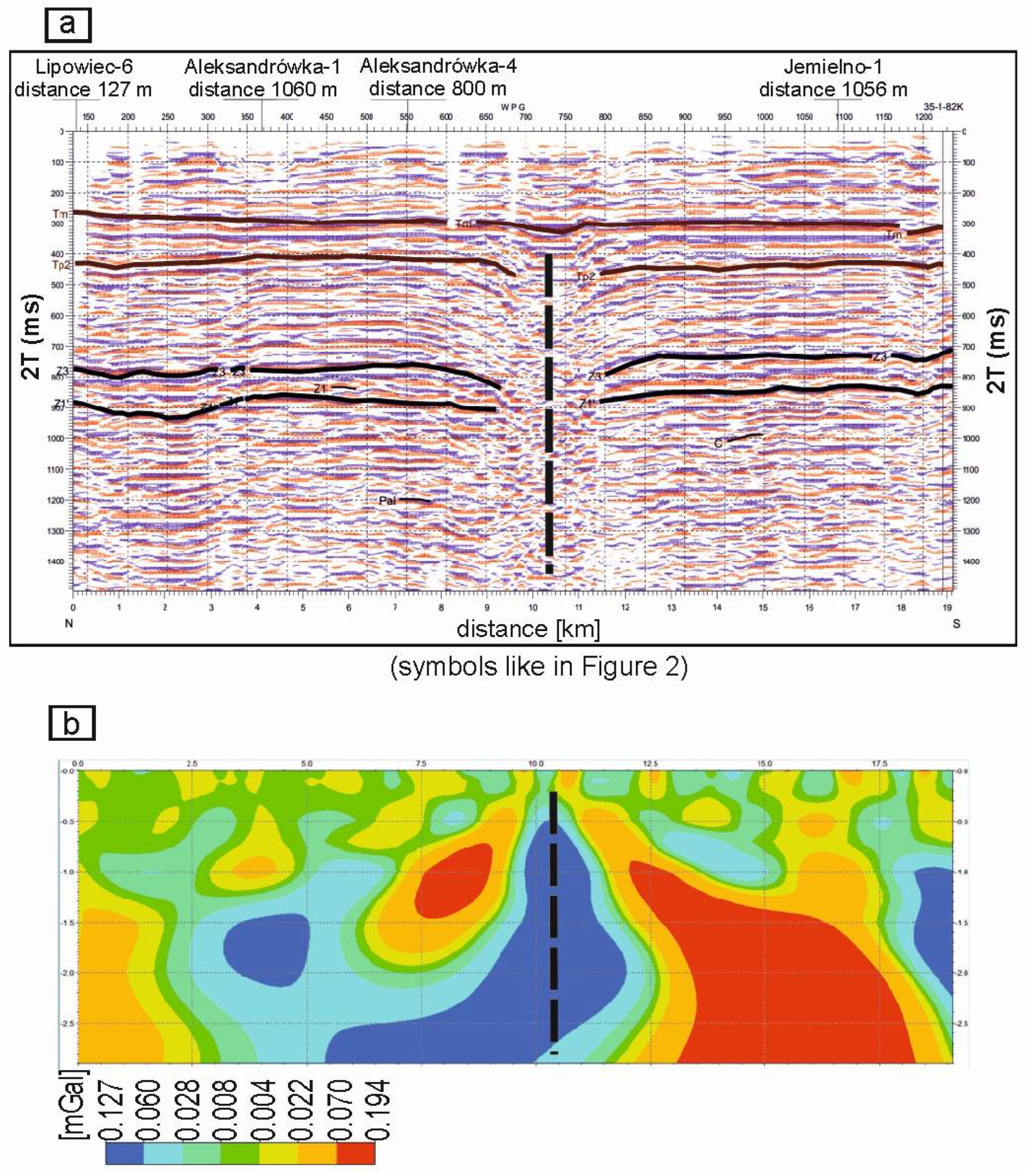
7. Tectonic Characteristics of the Northern Copper Belt Deposits

7.1. Nowa Sól

In the Nowa Sól deposit, the dip of strata ranges from 3 to 20 degrees in the north-east direction. This area, like the rest of the Fore-Sudetic Monocline, is characterized by a normal block-fault tectonic setting. The deposit is located within the Middle Oder fracture zone, which extends in the NW–SE direction and is bounded by the Silesian–Lubusz fault to the south [51]. This zone played an important role in the sedimentation of Permo-Carboniferous deposits, as there were numerous tectonic troughs here before the Zechstein [52]. The horizontal extent of the horsts can be variable, ranging from a few meters to several kilometers. One of these horsts may be located in the southern part of the deposit, which is characterized by the smallest thicknesses of PZ1 units, which may indicate the presence of intraformational erosion. The NW–SE faults are typically gravitational, with a simple structure, slip surfaces dipping at an angle of 65–80 degrees, and a displacement of up to several tens of meters.
There are also faults with an east–west orientation. These are normal and reverse faults with displacements of up to several dozen meters and lengths sometimes exceeding 10 kilometers. Numerous secondary deformations are associated with this direction of dislocation, such as steep dips, folded layers, and tectonic slices. Additionally, along these east–west tectonic lines, there was a left-lateral displacement of faults belonging to the NW-SE system and their attenuation. Observations and measurements performed in the mining areas of the Lubin–Sieroszowice deposit provide a basis to expect, by analogy, numerous minor faults in the area of the Nowa Sól deposit. They should not form distinct, regional linear displacements, but rather zones composed of small-scale fault sets.
Continuous deformations (brachyanticlines) with amplitudes ranging from 50 to 150 m occur locally. They are associated with salt tectonics, as indicated by small-scale, presumably thrust-related, salt domes and pillows (e.g., the Na4 salt in the NS C3 borehole, or the Na1 salt in the NS C3 and NS C22 boreholes). Reinterpretation of geophysical data confirmed the attenuation of faults in the Na1 salt layers [53], whose thickness in the Nowa Sól area reaches up to 322 m. Local increases in salt thickness can result from both varied paleorelief of the Rotliegend sandstones and halokinesis.
Determining the age of the dislocations is difficult due to the observed recurrence of certain tectonic directions over time. This is particularly true for the NW-SE-oriented faults and fractures, which formed during both the Kimmerian and Laramide orogenesis. It is believed that most of the dislocations cutting through the Zechstein were formed before the Triassic, with significantly fewer faults forming in the post-Triassic period. As a result of the late Permian tectonic movements, numerous horsts and troughs visible on the seismic sections were developed.

7.2. Sulmierzyce North

The Sulmierzyce North deposit is located in the eastern part of the Fore-Sudetic Monocline [54], where the Permian–Mesozoic structural stage deposits lie unconformably on the Carboniferous basement. The Variscan structural stage is characterized by significant tectonic involvement (dips in the Lower Carboniferous and older Paleozoic range from 30 to 90 degrees). The overlying Permian–Mesozoic unit consists of the Rotliegend, Zechstein, Triassic, and (locally) Jurassic and Cretaceous formations and features relatively small dips from 3 to 20 degrees toward the north-east. All o these formations are unconformably overlain by the Cenozoic.
Among the general monoclinal setting, numerous structural elements such as uplifts occur in the Sulmierzyce North region (e.g., the Świeca, Chruszczyn, and Dębica structures). In the Sulmierzyce North deposit, similarly to other parts of the Fore-Sudetic Monocline, NW–SE-oriented faults are the most numerous.
The northern part of the documented area is intersected by regional normal faults forming horst and grabens. One of such W–E-oriented grabens is located in the northern part of the Sulmierzyce North deposit. It is filled with Lower and Middle Jurassic as well as Cretaceous sedimentary rocks. Within the trough, there is a significant increase in the thickness of the Triassic compared to the central and southern parts of the Sulmierzyce North deposit. The Sulmierzyce C22 drillhole, located along the axis of the abovementioned structure, penetrated Lower and Middle Jurassic strata. This structure is associated with very rich copper mineralization in the lower Zechstein rocks. The exact extent of fault-related activity associated with the formation of this tectonic trough is not fully known.

7.3. Mozów

The Mozów deposit is situated in the western part of the Fore-Sudetic monocline, where a Variscan basement is covered with Permian and Triassic rocks. The Cenozoic sediments unconformably overlie upper Triassic rocks. Similarly to the Nowa Sól deposit, Permo-Triassic formation features relatively small dips from 5 to 20 degrees toward the north.
The documented area, like the entire Fore-Sudetic Monocline, is characterized by a fault-block structure. Dislocations in the NW-SE direction predominate, but faults in the latitudinal direction are also commonly observed. The NW-SE faults are traceable throughout the entire deposit. They have been correlated with each other in all of the seismic profiles extending north–south. The bottom surface of the Zechstein formations within the Mozów deposit dips northwards. Locally, these faults may branch out into a series of smaller discontinuous deformations.
Major discontinuous deformations result in the deposit area being shaped into three gently inclined terraces, separated by fault zones with displacements ranging from 20 to 60 m. The first such level was identified in the southern part of the deposit, near the historical Mozów 2 borehole. The depth of the base of the Zechstein in this level ranges from 2250 to almost 2350 m below ground level. In the southern and central parts of the Mozów deposit, encompassing the area intersected by the Mozów 1, Mozów-1 C1, and Mozów-1 C3 boreholes, a second terrace was identified. The base of the Zechstein is estimated to lie at depths from 2350 to even 2500 m below ground level at this level. The third terrace was delineated in the northern part of the deposit, in the area penetrated by the archival boreholes Kije 2, Kije 9, and Kije 10. At this level, the base of the Zechstein lies at depths ranging from 2500 to 2650 m below ground level.

8. Concluding Remarks

The very vast area of investigation (over 12,000 km2), especially compared to the mining area of the New Copper District deposits (760 km2), allowed for a better understanding of the metallogenic potential of the whole Fore-Sudetic Monocline. The huge amount of reprocessed geophysical data, and cores from the mineralized Zechstein horizon that were analyzed for the first time ever in terms of their chemical, mineralogical, and geochemical composition, have created a basis for an extensive drilling program conducted by Miedzi Copper Corp. Tectonic exploration and a wide scope of employed geochemical indicators of high-grade mineralization allowed for the selection of areas for drilling, limited to the so-called hot spots characterized by a high probability of finding rich copper–silver ore.
The inference that high-grade ore is associated with the so-called strong Rote Fäule was proved, and at the present stage of exploration, it limited the range of rich mineralization in the Northern Copper Belt (NCB) to the southern slopes of the Wolsztyn High and its direct contacts with the Zielona Góra oxidized field and Rote Fäule areas surrounding the Pogorzela High. Thanks to proper use of the ERC method, the drilling program was very effective. Out of 40 drilled holes, including several side tracks, 36 reached a mineralized horizon, with 32 finding grades fulfilling the strict requirements of the investor’s economic criteria. Three new deposits were discovered and documented, which along with their prognostic surroundings and other prognostic areas form the Northern Copper Belt, with resources estimated at up to 80 million metric tons of copper. Economic evaluations show that they may be considered a future base of Cu-Ag and critical metals for the Polish and European industry. Due to the potential economic significance of the NCB, the Nowa Sól deposit is considered for submission as a strategic project under the European Union’s Critical Raw Materials Act.
The previously suggested epigenetic origin of Kupferschiefer mineralization in the European Zechstein metallogenic province has been additionally supported and confirmed. The tectonically related contacts of Rote Fäule with the reduced horizon, acting as conduits for mineralized fluids, evolved from the closely associated Lower Permian rocks and, to some extent, older deeper rocks. The major mineralogical and geochemical characteristics of the NCB including the metal zonation pattern are generally very similar to the deposits of the New and Old Copper Districts. However, due to the large area of the NCB and a distance of hundreds of kilometers between the discovered deposits and prognostic areas, some of the differences are more pronounced. They are related mostly to the morphology of the Zechstein basin, associated with a different style of substrate structure and varying sedimentary environments in the Zechstein sub-basins. The role of country rocks and metal leaching processes should not be neglected either, as the composition of ore is to some extent related to the composition of the related underlying rocks.
The lithology, mineral composition of the ore-bearing horizon, and zonation of the Nowa Sól deposit are generally similar to those of the Rudna mine. The sandstone ore prevails; however, an important role as a Cu-Ag carrier is played by the Kupferschiefer, which is only about 20 cm thick. In Nowa Sól, the metal zonation pattern is simply developed parallel to the Zielona Góra oxidized field. In Rudna, it is far more complicated due to Variscan-oriented major faults that have impacted the distribution of metals and due to mineralized dunes, in which sandstone ore is the primary component.
The Sulmierzyce North deposit lacks the sandstone one due to the high position of Rote Fäule, and also for sedimentological reasons. The main ore consists mainly of shales, which to some extent are similar to the copper-bearing marls (Kupfermergel) of the Old Copper District. Additionally, the occurrence of several Rote Fäule fields that are interfingered with the reduced sediments has affected the Cu-Ag-Pb-Zn zonation pattern both vertically and horizontally, making it far more complicated. The high lead content may be explained by Hercynian granitoid massifs present in the neighboring area.
The Mozów deposit does not have any clear equivalents anywhere in the whole Fore-Sudetic Monocline. Thick carbonate ore is the main type, accompanied by a small amount of shale. Due to the high position of Rote Fäule, the sandstone ore is also absent. The mineralogical composition is dominated by copper sulfides; the Ag content is lower than in Nowa Sól and higher than in Sulmierzyce North, and the Pb and Zn contents are also relatively low. This may be attributed to the small amounts of these metals in the direct substrate.
The scale and number of mineral examinations as well as the observed variability in mineral successions and mineral generations with the recorded replacement phenomena may suggest different timings of mineralization processes in different deposits, and even in some of their parts. Depending on local tectonics, mineralization may have been generated in a single continuous long process, in discrete phases, or in some places, the processes may have been reactivated after some periods of rest. These new observations may explain differences in the results of dating the Kupferschiefer mineralization. Such measurements were performed for different mineral compositions and various deposits. The results of tectonic exploration as presented herein suggest a timespan from the Late Permian to the Early Triassic.

Author Contributions

Conceptualization, S.S.; methodology, S.S.; software, T.B.; validation, K.Z. and S.S.; formal analysis, K.Z.; investigation, A.P. and T.B.; resources, S.S. and K.Z.; data curation, K.Z.; writing—original draft preparation, S.S., A.P. and T.B.; writing—review and editing, K.Z.; visualization, K.Z. and T.B.; supervision, S.S.; project administration, S.S. and K.Z. All authors have read and agreed to the published version of the manuscript.

Funding

This study received no external funding.

Data Availability Statement

The data are unavailable due to the confidentiality of the geological information acquired by Miedzi Copper Corp.

Conflicts of Interest

K.Z. and S.S. are employees of Miedzi Copper Corp. This paper reflects the views of the scientists and not the company. S.S. is an employee of the University of Warsaw. This paper reflects the views of the scientist and not the university. T.B. is an employee of the Polish Geological Institute–National Research Institute. This paper reflects the views of the scientist and not the company. A.P. is a doctorand at the University of Warsaw. This paper reflects the views of the scientist and not the university.

References

  1. Wyżykowski, J. Zechstein copper-bearing formation in Poland. Prz. Geol. 1971, 19, 117–122. [Google Scholar]
  2. Oszczepalski, S.; Rydzewski, A. Metallogenic Atlas of the Zechstein Copper-Bearing Series in Poland; Polish Geological Institute-National Research Institute: Warsaw, Poland, 1997. [Google Scholar]
  3. Oszczepalski, S.; Chmielewski, A. Predicted metallic resources in Poland: Presented on the prospective maps at scale 1:200,000–copper, silver, gold, platinum and palladium in the Kupferschiefer ore series. Prz. Geol. 2015, 63, 534–545. [Google Scholar]
  4. Speczik, S.; Oszczepalski, S.; Nowak, G.; Karwasiecka, M. Kupferschiefer–A hunt for new reserves. Biul. Państw. Inst. Geol. 2007, 423, 173–188. [Google Scholar]
  5. Oszczepalski, S.; Speczik, S. Złoża prognostyczne rud miedzi na Monoklinie Przedsudeckiej–nowa perspektywa. In Geolodzy W Służbie Polskiej Miedzi; Banaszak, A., Downorowicz, S., Leszczyński, R., Mudry, D., Eds.; Konferencja Środowiskowa Geologów: Lubin, Polska, 2011; pp. 67–85. [Google Scholar]
  6. Speczik, S.; Püttmann, W. Origin of Kupferschiefer mineralization as suggested by coal petrology and organic geochemical studies. Acta Geol. Pol. 1987, 37, 167–187. [Google Scholar]
  7. Püttmann, W.; Merz, C.; Speczik, S. The secondary oxidation of organic material and its influence on Kupferschiefer mineralization of southwest Poland. Appl. Geochem. 1989, 4, 151–161. [Google Scholar] [CrossRef]
  8. Speczik, S. Kupferschiefer mineralization in the light of organic geochemistry and coal petrology studies. Geol. Quart. 1994, 38, 639–650. [Google Scholar]
  9. Bechtel, A.; Gratzer, R.; Puttmann, W.; Oszczepalski, S. Variable alteration of organic matter in relation to metal zoning at the Rote Fäule front (Lubin-Sieroszowice mining district, SW Poland). Org. Geochem. 2001, 32, 377–395. [Google Scholar] [CrossRef]
  10. Oszczepalski, S.; Nowak, G.J.; Bechtel, A.; Žák, K. Evidence of oxidation of the Kupferschiefer in the Lubin-Sieroszowice deposit: Implications for Cu-Ag and Au-Pt-Pd mineralisation. Geol. Quart. 2002, 46, 1–23. [Google Scholar]
  11. Oszczepalski, S.; Speczik, S. Maturity assessment by Rock-Eval pyrolysis as an exploration tool, Kupferschiefer, Poland. In Smart Science for Exploration and Mining, Proceedings of the tenth Biennial SGA Meeting, 17–20 August 2009; Williams, P.J., Ed.; James Cook University: Townsville, Australia, 2009; Volume 2, pp. 734–736. [Google Scholar]
  12. Karwasiecka, M. Analysis of Parameters of Thermal Field in Poland, National Geological Archive, Polish Geological Institute-National Research Institute: Warsaw, Poland, 2001; unpublished.
  13. Speczik, S. The Kupferschiefer mineralization of Central Europe: New aspects and major areas of future research. Ore Geol. Rev. 1995, 9, 411–426. [Google Scholar] [CrossRef]
  14. Bieńko, T.; Wierchowiec, J.; Pietrzela, A. Silver, cobalt and nickel mineralogy and geochemistry of shale ore in the sediment-hosted stratiform Nowa Sól copper-silver deposit, SW Poland. Geochem-Explor. Environ. Anal. 2023, 23, geochem2023-035. [Google Scholar] [CrossRef]
  15. Oszczepalski, S.; Speczik, S. Copper and silver ores. In The Balance of Mineral Prospective Resources in Poland as of 31.12.2009; Wołkowicz, S., Smakowski, T., Speczik, S., Eds.; Polish Geological Institute: Warsaw, Poland, 2011; pp. 76–93. (In Polish) [Google Scholar]
  16. Oszczepalski, S.; Rydzewski, A. Copper bearing Permian rocks in areas adjoining the Lubin-Sieroszowice deposits. Prz. Geol. 1983, 26, 437–444. [Google Scholar]
  17. Rydzewski, A. Oxidated facies of the copper-bearing Zechstein shale in the Fore-Sudetic monocline. Prz. Geol. 1978, 26, 102–108. [Google Scholar]
  18. Oszczepalski, S.; Rydzewski, A. The Kupferschiefer mineralization in Poland. Zbl. Geol. Paläont. Teil I 1991, 4, 975–999. [Google Scholar]
  19. Speczik, S.; Skowronek, C.; Friedrich, G.; Diedel, R.; Schumacher, C.; Schmidt, F.P. The environment of generation of some base metal Zechstein occurrences in central Europe. Acta Geol. Pol. 1986, 36, 1–35. [Google Scholar]
  20. Piestrzyński, A. Historyczny rozwój poglądów na genezę złoża rud miedzi na monoklinie przedsudeckiej–dyskusja. Biul. Państw. Inst. Geol. 2007, 423, 69–76. [Google Scholar]
  21. Irvine, R.J.; Smith, M.J. Geophysical exploration for epithermal gold deposits. J. Geochem. Explor. 2007, 36, 375–412. [Google Scholar] [CrossRef]
  22. Basokur, A.T.; Rasmussen, T.M.; Kaya, C.; Altun, Y.; Aktas, K. Comparison of induced polarization and controlled-source audio-magnetotellurics methods for massive chalcopyrite exploration in a volcanic area. Geophysics 1997, 62, 1087–1096. [Google Scholar] [CrossRef]
  23. Farquharson, C.G.; Craven, J.A. Three-dimensional inversion of magnetotelluric data for mineral exploration: An example from the McArthur River uranium deposit, Saskatchewan, Canada. J. Appl. Geophys. 2009, 68, 450–458. [Google Scholar] [CrossRef]
  24. Znosko, J. The problem of the oceanic crust and of ophiolites in the Sudetes. Bull. Acad. Pol. Sci. Ser. Terre 1981, 29, 185–197. [Google Scholar]
  25. Franke, W.; Żelaźniewicz, A.; Porębski, S.J.; Wajsprych, B. The Saxothuringian zone in Germany and Poland: Differences and common features. Geol. Rundsch. 1993, 82, 583–599. [Google Scholar] [CrossRef]
  26. Speczik, S. Mineralizacja kruszcowa w utworach karbońskich podłoża monokliny przedsudeckiej. Geol. Sudet. 1979, 14, 77–122. (In Polish) [Google Scholar]
  27. Speczik, S.; Szamałek, K.; Wierchowiec, J.; Zieliński, K.; Pietrzela, A.; Bieńko, T. The new Northern Copper Belt of south-western Poland: A summary. Acta Geol. Pol. 2022, 72, 469–477. [Google Scholar]
  28. Dziewińska, L.; Pepel, A.; Tarkowski, R.; Żuk, Z. Nowe spojrzenie na wyniki badań geofizycznych monokliny przedsudeckiej w aspekcie poszukiwań surowców mineralnych. Biul. Państw. Inst. Geol. 2017, 468, 165–174. [Google Scholar]
  29. Rudnitskaya, D.I.; Danenberg, E.E.; Belozerov, V.B. Principy vydelenija sejsmociklitov v kontinentalnyh otlozhenijah jury Zapadno-Sibirskoj plity v svjazi s poiskami neantiklinalnyh zalezhej nefti i gaza. In Prikladnye Voprosy Sedimentacionnoj Ciklichnosti I Neftegazonosnosti; Nauka: Novosybirsk, Russia, 1987; pp. 67–72. [Google Scholar]
  30. Rentzsch, J.; Knitzschke, G. Die Erzmineralparagenesen des Kupferschiefer und ihre regionale Verbreitung. Freib. Forschungshefte C 1968, C231, 189–211. [Google Scholar]
  31. Rentzsch, J. The Kupferschiefer in comparison with the deposits of the Zambian Copperbelt. Annales de la Société Géologique de Belgique 1974, 395–418. [Google Scholar]
  32. Marowsky, G. Schwefel-, Kohlenstoff- und Sauerstoff-Isotopenuntersuchungen am Kupferschiefer als Beitrag zur genetischen Deutung. Contrib. Mineral. Petrol. 1969, 22, 290–334. [Google Scholar] [CrossRef]
  33. Bischof, J.L.; Radtke, A.S.; Rosenbauer, R.L. Hydrothermal alteration of greywacke by brine and seawater: Roles of alteration and chloride complexing on metal solubulisation at 200 °C and 350 °C. Econ. Geol. 1981, 76, 659–676. [Google Scholar]
  34. Eugster, H.P. Oil shales evaporites and ore deposits. Geochim. Cosmochim. Acta 1985, 49, 619–635. [Google Scholar] [CrossRef]
  35. Püttmann, W.; Hageman, H.W.; Merz, C.; Speczik, S. Influence of organic material on mineralization processes in the Permian Kupferschiefer Formation, Poland. Org. Geochem. 1988, 13, 357–363. [Google Scholar] [CrossRef]
  36. Radke, K.; Willsch, H.; Leythaeuser, D.; Teichmüller, M. Aromatic components of coal: Relation of distribution pattern to rank. Geochim. Cosmochim. Acta 1982, 46, 1831–1848. [Google Scholar] [CrossRef]
  37. Bechtel, A.; Puttmann, W. The origin of the Kupferchiefer-type minseralization in the Richelsdorf hills, Germany, as deduced from stable isotope and organic geochemical studies. Chem. Geol. 1991, 91, 1–18. [Google Scholar] [CrossRef]
  38. Püttmann, W.; Bechtel, A.; Speczik, S.; Fermont, W.J.J. Combined application of various geochemical methods on Kupferschiefer of the North-Sudetic Syncline, SE Poland: Evidence for post-depositional accumulation of copper and silver. In Proceedings of the 2nd Biennial SGA Meeting, Granada, Spain, 9–11 September 1993; pp. 213–216. [Google Scholar]
  39. Bechtel, A.; Hoernes, S. Stable isotopic variation of clay minerals: A key to understanding of Kupferschiefer-type mineralization, Germany. Geochim. Cosmochim. Acta 1993, 57, 1799–1816. [Google Scholar] [CrossRef]
  40. Speczik, S.; Strengel, J.; Jankowski, J. Epigenetic veins in Kupferschiefer deposits of SW Poland. Arch. Mineral. 1993, XLIX, 203–205. [Google Scholar]
  41. Püttmann, W.; Fermont, W.J.J.; Speczik, S. The possible role of organic matter in transport and accumulation of metals exemplified at the Permian Kupferschiefer formation. Ore Geol. Rev. 1991, 6, 563–579. [Google Scholar] [CrossRef]
  42. Bechtel, A.; Gratzer, R.; Püttmann, W.; Oszczepalski, S. Geochemical characteristics across the oxic/anoxic interface (Rote Fäule front) within the Kupferschiefer of the Lubin-Sieroszowice mining district (SW Poland). Chem. Geol. 2002, 185, 9–31. [Google Scholar] [CrossRef]
  43. Oszczepalski, S. Kupferschiefer in southwestern Poland: Sedimentary environments, metal zoning, and ore controls. In Sediment-Hosted Stratiform Copper Deposits; Boyle, R.W., Brown, A.C., Jowett, E.C., Kirkham, R.V., Eds.; Geological Association of Canada Special Paper 36; Geological Association of Canada: Ottawa, ON, Canada, 1989; pp. 571–600. [Google Scholar]
  44. Oszczepalski, S.; Speczik, S.; Zieliński, K.; Chmielewski, A. The Kupferschiefer deposits and prospects in SW Poland: Past, Present and Future. Minerals 2019, 9, 592. [Google Scholar] [CrossRef]
  45. Majorowicz, J. Problems of tectonic interpretation of geothermal field distribution in the platform area of Poland. Publ. Inst. Geophys. AB 1984, 160, 149–157. [Google Scholar]
  46. Speczik, S. Relation of Permian Base Metal Occurrences to the Variscan Paleogeothermal Field of the Fore-Sudetic Monocline (South-Western Poland). In Base Metal Sulphide Deposits; Friedrich, G., Herzig, P., Eds.; Springer Verlag: Berlin-Heidelberg, Germany, 1988; pp. 12–24. [Google Scholar]
  47. Jowett, E.C.; Rydzewski, A.; Jowett, R.J. The Kupferschiefer Cu-Ag ore deposits in Poland: A re-appraisal of the evidence of their origin and presentation of a new genetic model. Can. J. Earth Sci. 1987, 24, 2016–2037. [Google Scholar] [CrossRef]
  48. Downorowicz, S. Geothermics of the copper ore deposit of the Fore-Sudetic monocline. Pr. Inst. Geol. 1983, 106, 88. [Google Scholar]
  49. Zielińki, K.; Speczik, S. The Northern Copper Belt—A chance for a new giant copper district in Poland. In Proceedings of the 17th SGA Biennial Meeting ‘Mineral Resources in a Changing World’, Zurich, Switzerland, 28 August–1 September 2023; Volume 3, pp. 110–113. [Google Scholar]
  50. Pietrzela, A.; Bieńko, T. Mineralogy and geochemistry of the Kupferschiefer in the Nowa Sól, Mozów and Sulmierzyce North Cu-Ag deposits, Northern Copper Belt, SW Poland. Geol. Q. 2024; in press. [Google Scholar] [CrossRef]
  51. Kiersnowski, H.; Petecki, Z. Geology of the Zechstein basement of the Legnica-Głogów copper district (LGOM) and its surroundings: A critical overview. Biul. Państw. Inst. Geol. 2017, 468, 175–198. [Google Scholar] [CrossRef]
  52. Dziewińska, L.; Tarkowski, R.; Bieńko, T. Reinterpretation of geophysical surveys of pre-Permian basement in SW Poland: Structural evolution and its implications for prospecting Cu and other ores. Gospod. Surowcami. Min. 2020, 36, 187–216. [Google Scholar]
  53. Kijewski, P.; Salski, W. Zechstein rock-salt of the Z1 cyclothem in the south-western part of the Fore-Sudetic Monocline. Geol. Sudet. 1978, 13, 97–139. [Google Scholar]
  54. Narkiewicz, M.; Dadlez, R. Geological regional subdivision of Poland: General guidelines and proposed schemes of sub-Cenozoic and sub-Permian units. Prz. Geol. 2008, 56, 391–397. [Google Scholar]
Figure 1. Gravimetric map. Residual anomalies; BTWR filter in conventional depth interval of 2800–5000 m.
Processes 12 01592 g001
Figure 2. Effective reflection coefficients in seismic section TA220782 from Nowa Sól deposit.
Processes 12 01592 g002
Figure 3. Presentation of tectonic zones on (a) seismic sections (ERC); (b) gravimetric sections.
Processes 12 01592 g003
Figure 4. Results of Rock-Eval pyrolysis for Kupferschiefer samples in SW Poland: hydrogen index vs. maximum temperature.
Processes 12 01592 g004
Figure 5. Histograms of vitrinite reflectance against depth for historical S-236 borehole.
Processes 12 01592 g005
Figure 6. Map of Cu-Ag deposits and prospects in SW Poland—Northern Copper Belt deposits and prospects; New Copper District and Old Copper District.
Processes 12 01592 g006
Figure 7. Reflected light photomicrographs of samples from the Nowa Sól deposit: (A) bornite–chalcocite semi-massive mineralization in the top of the mineralized Zechstein limestone of the Cu-bearing zone (the NS C33 borehole); (B) a sphalerite–bornite–galena aggregate in the mineralized Zechstein limestone of the Pb-Zn-bearing zone (the NS C15 borehole); (C) bornite and chalcocite massive mineralization in the copper-bearing shale of the Cu-bearing zone (the NS C30 borehole); (D) chalcocite nests and elongated lenses with µm-scale pyrite in the Cu-bearing zone (the NS C15 borehole); (E) chalcocite accompanied by native Ag filling spaces between quartz grains in the mineralized white sandstone in the Cu-bearing zone (the NS C30 borehole); (F) massive chalcocite mineralization in the top of the white sandstone; note chalcocite pervasively replacing K-feldspar grains in the Cu-bearing zone (the NS C29 borehole). Abbreviations: Ag—native silver, bn1—bornite (orange), bn2—bornite (purple), cc—chalcocite, dg—digenite, cp—chalcopyrite, gn—galena, py—pyrite, and sph—sphalerite.
Processes 12 01592 g007
Figure 8. Reflected light photomicrographs of the samples from the Sulmierzyce North deposit: (A) massive chalcopyrite mineralization in the copper-bearing shale in the Cu-bearing zone (the SUL C20 borehole); (B) aggregates of framboidal pyrite cemented with chalcopyrite and chalcopyrite replacing foraminifera in the copper-bearing shale in the Cu-bearing zone (the SUL C22 borehole); (C) a sphalerite–pyrite–chalcopyrite aggregate in the copper-bearing shale in the Cu-Zn-Pb-bearing zone (the SUL C22 borehole); (D) bornite–chalcocite lenses and aggregates in the copper-bearing (marly) shale in the Cu-bearing zone (the SUL C22 borehole). Abbreviations: bn1—bornite (orange), cc—chalcocite, dg—digenite, cp—chalcopyrite, py—pyrite, and sph—sphalerite.
Processes 12 01592 g008
Figure 9. Reflected light photomicrographs of the samples from the Mozów deposit: (A) a pyrite–bornite–chalcopyrite aggregate in the Zechstein limestone in the Cu-Zn-Pb-bearing zone (the MOZ C1 borehole); (B) chalcocite filling the central part of an oncolite in the Zechstein limestone in the Cu-bearing zone (the MOZ C1 borehole); (C) chalcocite pseudo-veinlets perpendicular to shale lamination in the copper-bearing shale in the Cu-bearing zone (the MOZ C1 borehole); (D) massive chalcocite mineralization in the copper-bearing shale in the Cu-bearing zone (the MOZ C1 borehole). Abbreviations: bn1—bornite (orange), bn2—bornite (purple), cc—chalcocite, cp—chalcopyrite, and py—pyrite.
Processes 12 01592 g009
Table 1. Summary of historical boreholes from petroleum industry analyzed for copper project.
CompanyBoreholes LoggedBoreholes Sampled for Chemical Tests
(Channel Samples)
Boreholes Sampled for Chemical Tests
(Discrete Samples)
Boreholes Sampled for Petrographic TestsBoreholes Tested with the Portable XRF Analyser Only
No. of HolesNo. of HolesNo. of SamplesNo. of HolesNo. of SamplesNo. of HolesNo. of SamplesNo. of HolesNo. of Samples
Ostrzeszów Copper (Warsaw, Poland)12152117697367471118
Wilcze Copper (Warsaw, Poland)9519236163116322277
Zielona Góra Copper (Warsaw, Poland)83570032100
Mozów Copper (Warsaw, Poland)324700118114
Florentyna Copper (Warsaw, Poland)86274259523820012102
Leszno Copper (Warsaw, Poland)98276185163220814
TOTAL411130255924147172108137415
Table 2. The resources of the documented deposits in the Northern Copper Belt (NCB).
Nowa SólSulmierzyce NorthMozówTotal NCB
Polish categoryC2C2 + DC2C2, C2 + D
Ore (Mt)846,262267,171223,5891,337,022
Copper (kt)10,9595431426920,659
Silver (kt)35.326.895.7247.93
Lead (kt)1640.73715.9928.502385.22
Zinc (kt)402.381132.4014.651549.43
Cobalt (kt)15.9222.642.6641.22
Molybdenum (kt)18.5625.996.5551.10
Nickel (kt)15.0018.899.2643.15
Vanadium (kt)22.2144.5431.3198.06
Disclaimer/Publisher’s Note: The statements, opinions and data contained in all publications are solely those of the individual author(s) and contributor(s) and not of MDPI and/or the editor(s). MDPI and/or the editor(s) disclaim responsibility for any injury to people or property resulting from any ideas, methods, instructions or products referred to in the content.

