1. Introduction
Truck platooning has emerged as a promising approach to improve transportation efficiency, fuel consumption, and road safety. In a platoon, multiple trucks follow seamlessly each other at close distances, leveraging advanced sensing and communication technologies to maintain a constant gap, allowing them to benefit from reduced aerodynamic drag and improved fuel efficiency [
1,
2]. Traditional platooning systems rely on vehicle-to-vehicle (V2V) communication and centralized control strategies, which can be prone to latency and scalability issues.
Recent advancements in drone technology and Ultra-Wideband (UWB) sensors offer new opportunities to develop innovative solutions for truck platooning. Drones, or Unmanned Aerial Vehicles (UAVs), can serve as mobile monitoring and control platforms, providing real-time data and feedback to optimize formation of platoons and maintenance. Furthermore, UWB technology enables accurate distance measurement and positioning with high precision and robustness, making it well-suited for platooning applications.
In this study, we present a unique contribution in the field of truck platooning systems. We introduce a decentralized strategy, utilizing drones equipped with UWB sensors for precise distance control. The system also incorporates a multi-objective optimization approach, targeting enhancements in fuel efficiency, safety, and travel time.
The incorporation of drones in our proposed platooning system presents several crucial advantages. Firstly, drones equipped with UWB sensors can efficiently provide a bird’s eye view of the traffic situation. This aerial perspective not only aids in forming accurate and efficient platoons but also enables real-time monitoring and management of the formed platoons, which is a task that would be challenging from a ground-based viewpoint. Additionally, drones can navigate independently of the traffic flow, bypassing the constraints that ground vehicles face, thereby providing continuous and uninterrupted monitoring. The mobility and agility of drones make them particularly effective in dynamic and rapidly changing environments. In cases of sudden traffic alterations, drones can swiftly react and recalibrate their strategies, ensuring the seamless operation of the platooning system. These attributes position drones as essential components in our proposed truck platooning system, contributing significantly to its efficiency, adaptability, and resilience.
This novel technology can certainly speed up the following use cases:
Long-haul Freight Transportation: The proposed system greatly benefits long-haul transport, where trucks often cover vast highway distances. Platooning, facilitated by our system, effectively reduces air resistance, leading to significant fuel savings and a consequent reduction in carbon emissions. Furthermore, it promotes road safety and reduces traffic congestion by maintaining optimal inter-vehicle distances.
Urban Logistics: In response to growing urbanization and associated traffic challenges, our drone-based truck platooning system can be integrated into smart city infrastructure to improve logistics efficiency. This would enhance routing, decrease delivery times, and reduce the environmental impact of city-wide logistics operations.
Emergency Response: In situations requiring the rapid transportation of supplies and personnel, such as in disaster relief scenarios, our platooning system can enhance the speed and effectiveness of resource allocation and delivery.
Autonomous Vehicles: The rise of autonomous vehicles presents another valuable application for our platooning system. When integrated with self-driving trucks, our system can offer significant improvements in efficiency and safety, heralding a new era in autonomous transportation.
The transformative potential of the Internet of Things (IoT) in redefining our interaction with the environment is being progressively realized across various sectors. The proposed drone-based decentralized truck platooning system, enabled with UWB sensors, has a spectrum of potential applications. These range from long-haul freight transportation and smart city logistics to emergency response initiatives and military operations. In this novel application of IoT, we envision a transformative potential capable of revolutionizing transportation systems, making them more efficient, sustainable, and secure.
Key aspects of our contribution include the following:
The implementation of a novel, drone-based, decentralized platooning system, employing UWB sensors for meticulous distance measurement and control.
The development of a multi-objective optimization technique, effectively forming and managing platoons, thereby optimizing travel time, fuel efficiency, and safety.
The utilization of an agent-based simulation model to evaluate and compare the performance of our proposed system with existing methodologies in platooning.
We believe that this distinct combination of technology and strategy will substantially improve current platooning systems.
The rest of this paper is organized as follows:
Section 2 reviews related work on truck platooning, drone-based systems, and UWB technology in transportation.
Section 3 provides an overview of the proposed system, including agents for trucks and drones, UWB sensing and communication, and decentralized platooning architecture.
Section 4 details the strategy for multi-objective optimization and formation of platoons.
Section 5 discusses UWB-based positioning and control.
Section 6 presents the simulation setup, results, and performance evaluation. Finally,
Section 7 concludes the paper and discusses potential future work.
2. Related Work
Truck platooning has been extensively studied in recent years as a means to improve transportation efficiency, reduce fuel consumption, and enhance road safety [
1,
2,
3,
4]. Most existing platooning systems rely on V2V communication and centralized control strategies, where a lead truck is responsible for coordinating the actions of the following trucks. However, centralized approaches can suffer from latency, scalability, and robustness issues, which have motivated the development of decentralized platooning solutions [
5,
6,
7,
8].
The use of drones in transportation has been explored for various applications, such as traffic monitoring [
9], road infrastructure inspection [
10], and vehicle tracking [
11]. Drones can provide valuable real-time data [
12] and act as mobile communication relays, enabling flexible and efficient control in transportation systems [
13]. A few studies have investigated the potential of drones for facilitating truck platooning [
14], but the integration of advanced sensing and communication technologies, such as UWB, remains an open research question.
UWB technology has gained significant attention for its potential in high-precision positioning, ranging, and communication applications [
15,
16,
17,
18,
19]. UWB’s ability to provide accurate distance measurements, robustness to multipath effects, and low power consumption make it a suitable candidate for transportation systems. Several studies have explored the use of UWB for vehicle localization, collision avoidance, and V2V communication [
20,
21,
22,
23]. However, the application of UWB in drone-based decentralized truck platooning remains largely unexplored.
This paper aims to address the gap in the literature by proposing a novel drone-based decentralized platooning system that leverages UWB sensors for distance estimation and control. By integrating the advantages of drone-based monitoring and UWB technology, our proposed system aims to overcome the limitations of existing platooning strategies while improving transportation efficiency, fuel consumption, and safety.
3. System Overview
Before detailing the components of our proposed drone-based decentralized truck platooning system, we present the notation in
Table 1 for clarity.
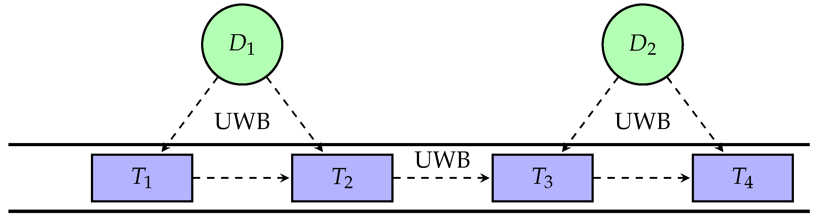
Our proposed drone-based decentralized truck platooning system consists of two main components: the agents for trucks, and the agents for drones. The system is designed to optimize fuel efficiency, travel time, and safety using UWB technology for precise distance estimation and control, as illustrated in
Figure 1.
Each truck in the platooning system is equipped with a UWB sensor, which allows it to accurately measure the distance to neighboring trucks. The agents for trucks use a decentralized control algorithm that takes into account the following variables:
: distance between truck z and truck o;
: current speed of truck z;
: optimal speed of truck z to maximize fuel efficiency;
: acceleration factor, which determines the responsiveness of the trucks to changes in distance.
The control algorithm computes the desired acceleration
for each truck
z as follows:
where
represents the optimal distance between trucks for maximizing fuel efficiency and safety. The acceleration factor
can be tuned to balance the trade-offs between responsiveness and stability in the platooning system.
The drones in our system serve as monitoring and communication facilitators for the platooning system, collecting distance and speed data from the trucks and relaying communication between them. Each drone is equipped with a UWB sensor and a communication module. This allows it to relay messages between the truck agents and estimate their relative distances.
The positioning of the drones is treated in two dimensions: they adjust their longitudinal positions to maintain a balanced distribution across the platoon while maintaining a fixed altitude. This allows them to optimally cover the length of the platoon without the complexity of managing vertical movement. The decentralized coordination algorithm the drones employ accounts for the following variables:
: longitudinal position of drone z along the platoon;
n: number of drones in the platoon;
N: number of trucks in the platoon.
The coordination algorithm computes the desired position
along the platoon for each drone
z as follows:
In the equation presented, the parameter z represents the index of a given drone within the platoon, which is used to calculate its desired longitudinal position, . The index z takes on integer values ranging from 1 to n, where n is the total number of drones in the platoon. This indexing is crucial for determining the precise spacing between drones to ensure balanced coverage. For instance, if there are five drones in a platoon, z would range from 1 to 5. The denominator, , ensures that the drones are evenly spaced along the platoon with the first and last drones positioned at the ends of the convoy. The product of and N (the total number of trucks in the platoon) yields the desired longitudinal position of each drone relative to the trucks.
By adjusting their positions to maintain the desired distribution, the drones ensure optimal coverage and efficient communication within the platooning system.
In truck platooning, the primary concern is the management of the convoy along the direction of travel, which is inherently a longitudinal problem. The drones in our system focus on longitudinal positioning to ensure that the platooning dynamics—such as slipstreaming for reduced air resistance and synchronized braking for safety—are optimized. Lateral or vertical movements of drones are less critical to these objectives and introduce unnecessary complexity into the system. Furthermore, by restricting drones to longitudinal adjustments, we simplify the control algorithms and reduce computational overhead, leading to a more efficient and responsive system. The longitudinal focus also aligns with highway driving regulations, where lateral movements are constrained by lane widths and vertical navigation is constrained by airspace regulations. Hence, our system is designed to operate within these practical limitations while delivering the intended benefits of platooning.
3.1. UWB-Based Distance Estimation
The UWB sensors are used to provide accurate and reliable distance measurements between the trucks and the drones. The distance
between truck
z and truck
o can be estimated using the Time of Arrival (ToA) method, as follows:
where
c is the speed of light and
is the time difference between the transmission and reception of a UWB pulse.
By leveraging UWB technology, our proposed system can achieve precise distance estimation and control, enabling efficient and safe truck platooning.
3.2. Decentralized Platooning Control
The trucks and drones collaborate to create and maintain platoons based on their distance, speed, and truck type. The decentralized platooning control algorithm consists of the following steps:
Each truck broadcasts its current state, including position, speed, fuel efficiency, and truck type, to the nearby drones using UWB communication.
The drones collect the state information from the trucks and estimate the distances between them using their UWB sensors.
The drones share the collected data with neighboring drones, ensuring that all have a consistent view of the platoon.
Based on the received data, each drone calculates a platooning decision for the trucks in its vicinity, taking into account the distance, speed, and compatibility constraints.
The drones communicate the platooning decisions to the corresponding trucks, which adjust their speed and position accordingly.
The trucks continuously update their state information and share it with the drones, allowing the platooning control algorithm to adapt to changes in the environment and traffic conditions.
This decentralized approach enables our platooning system to scale effectively, adapt to dynamic conditions, and maintain optimal performance in terms of fuel efficiency, travel time, and safety.
In the optimization of truck platooning, the determination of each truck’s optimal speed and the inter-vehicle distance within a platoon is crucial for enhancing fuel efficiency. These parameters are derived from aerodynamic models that consider factors such as air resistance and vehicle dynamics. While our paper does not delve into the specifics of these calculations, they are based on established principles in the field of transportation engineering. For an in-depth understanding of these models and their application to platooning, we refer readers to [
24,
25,
26], where these concepts are comprehensively analyzed and discussed.
3.3. Performance Metrics
The performance of our proposed system is evaluated based on the following metrics:
Fuel efficiency: We calculate fuel efficiency as the ratio of the total distance traveled to the total fuel consumed by each truck in the platoon, which is expressed in liter per km. This is computed by using the real-time data on fuel consumption and distance covered by each truck, which is obtained through the UWB sensors and the truck’s onboard diagnostics system. The average fuel efficiency of all trucks in the platoon is then calculated to represent the overall fuel efficiency of the platoon.
Travel time: This refers to the average time taken by a truck to travel a fixed distance, which is measured in minutes. The UWB sensors provide accurate data on the distance covered and time taken, which is used to calculate the average travel time for each truck and for the platoon as a whole.
Safety: We consider the average distance between trucks in the platoon as a proxy for the safety of the platooning system. This is measured using the UWB sensors, which provide precise data on the relative positions and distances between trucks in the platoon.
The primary objective of our drone-based decentralized truck platooning system is to optimize these metrics with the ultimate aim of achieving significant cost savings, reducing emissions, and improving road safety.
4. Multi-Objective Optimization and Formation of Platoons
In this section, we describe the multi-objective optimization that our drone-based decentralized truck platooning system aims to solve as well as the algorithm for the formation of platoons that we use to generate platooning decisions based on the collected data.
4.1. Multi-Objective Optimization
Our goal is to optimize the formation of platoons with respect to multiple objectives, including fuel efficiency, travel time, and safety. We formalize this problem as follows:
Let N be the number of trucks, and let be the set of trucks. Each truck is characterized by its fuel efficiency , optimal speed , and type . The distance between trucks and is denoted by .
The multi-objective optimization can be reformulated as shown below:
where
represents the average fuel efficiency of the platoon,
represents the average travel time,
represents the average safety (measured by the distance between trucks),
is the minimum allowable distance between trucks to ensure safety, and
is the maximum allowable distance between trucks for effective platooning.
In the context of our platooning system, the minimum safe distance between trucks, denoted as , is a critical parameter that ensures the safety of the platoon. This distance is not arbitrarily chosen but is informed by a combination of legal requirements for vehicle spacing, empirical research on stopping distances under various conditions, and industry best practices. For instance, traffic regulations often stipulate a minimum following distance based on factors such as vehicle size, speed, and road conditions. This parameter serves as a constraint in our optimization algorithm, ensuring that the operational safety of the platoon is upheld at all times.
4.2. Algorithm for Formation of Platoons
To solve the multi-objective optimization, we propose an algorithm for the formation of platoons based on the following steps:
Data Collection: The drones collect the state information from the trucks and estimate the distances between them using their UWB sensors. This information is shared among the drones to ensure a consistent view of the platoon.
Compatibility Analysis: For each pair of trucks
, the drones evaluate their compatibility based on their fuel efficiency, optimal speed, and truck type. A compatibility score
is calculated as follows:
where
are weight factors, and
is a function that returns 1 if
, and 0 otherwise.
Formation of Platoons: The drones use the compatibility scores and the distance information to form platoons by minimizing the weighted sum of the objectives. We use a greedy algorithm to achieve this:
- (a)
Initialize an empty set of platoons .
- (b)
For each truck , find the most compatible truck that is not already in a platoon, i.e., , and satisfies the distance constraint .
- (c)
If such a truck is found, create a new platoon and add it to the set of platoons P. Otherwise, create a singleton platoon and add it to P.
- (d)
Continue this process until all trucks are assigned to a platoon.
The weight factors , , and in the compatibility analysis play important roles in shaping the formation and dynamics of truck platoons. These factors are adjusted based on the relative importance of fuel efficiency, speed alignment, and truck type in the platooning algorithm. For instance, if fuel efficiency is prioritized, may be set higher than and , reflecting the desire to pair trucks with similar fuel consumption profiles. Conversely, if maintaining a consistent speed is deemed more critical, would assume a greater value. In our simulations, we propose starting values such as , , and , acknowledging that these may be fine-tuned through empirical testing or specific operational requirements.
In our compatibility analysis for truck platooning, the type of each truck is a categorical variable represented by for truck and for truck . These variables are indicative of the truck model, which can impact platoon dynamics due to size, aerodynamics, and other characteristics. The calculation of and is straightforward: each truck type is assigned a unique identifier (such as ‘A’, ‘B’, ‘C’, etc.). Thus, the comparison function evaluates to 1 if the truck types are different (i.e., ), implying incompatibility, and 0 if they are the same (i.e., ), indicating compatibility. This binary approach simplifies the determination of whether two trucks should be considered for platooning based on type without delving into a granular comparison of specific model characteristics, which are beyond the scope of our initial optimization formulation.
The algorithm implemented for platoon formation is designed to iteratively construct a set of platoons in a manner that seeks locally optimal solutions at each step with the goal of achieving a globally optimal set of platoons. The iterative nature of the algorithm comes from its selection process; it chooses the pair of trucks that, at the current iteration, seem to be the most compatible without considering future pairings. This approach does not guarantee a globally optimal set of platoons but is often efficient in terms of computational resources and time, making it suitable for real-time applications where decisions need to be made quickly.
The maximum allowable distance between two trucks in a platoon, denoted as , is a crucial parameter that balances the benefits of platooning with operational safety and regulatory compliance. This distance is influenced by various factors, including the reaction time of the autonomous systems, the braking capabilities of the trucks, environmental conditions, and legal restrictions on vehicle spacing. For the purposes of our model and simulations, is set based on a combination of these factors to ensure that trucks are close enough to benefit from reduced air resistance and thus improved fuel efficiency while also maintaining a safe buffer to react to unforeseen events.
In practical terms, can vary depending on the specific characteristics of the trucks, such as their size, weight, and braking systems, as well as the technology used for communication and control within the platoon. For instance, a commonly used guideline is that trucks maintain a distance that allows for at least one second of reaction time for every ten feet of vehicle length plus an additional second for safety. In highway conditions, where trucks typically travel at higher speeds, this can translate to a of approximately 50 to 60 m.
It is essential to note that is not a fixed value and can be adjusted based on real-time data and changing conditions. The drone-based system we propose is capable of dynamically recalibrating in response to changes in speed, traffic density, weather, and other relevant variables, thereby optimizing the platoon’s performance while ensuring safety is not compromised.
4.3. Operational Parameters of Platooning
Given the complexities involved in determining , our system includes mechanisms for real-time adjustment and monitoring to maintain optimal inter-vehicle distances. These mechanisms are designed to adapt to varying conditions, including the following:
Changes in speed: As the platoon’s speed increases, the system automatically increases to allow for longer reaction times.
Varying traffic conditions: In denser traffic, may be reduced to allow more vehicles to benefit from platooning, provided it remains within safe limits.
Weather impacts: Adverse weather conditions such as rain or fog will result in an increase in to account for decreased visibility and potential increases in braking distance.
In summary, serves as a flexible boundary within our platooning model, ensuring operational efficiency is matched with the imperative of safety.
4.4. Dynamic Management of Platoons
As the trucks move and their positions change, the formation of platoons may need to be updated to maintain the optimal configuration. To handle this dynamic aspect, the drones continuously monitor the distance between trucks and their compatibility. If the distance between two trucks in a platoon exceeds the maximum allowable distance, or their compatibility score drops significantly, the drones may decide to split the platoon and find new platoon partners for the affected trucks, as defined in the multi-objective optimization in
Section 4.2.
Figure 2 further illustrates the interconnection between the modules in a sequence diagram.
5. Positioning and Control Based on UWB
In this section, we discuss the role of Ultra-Wideband (UWB) technology in our drone-based decentralized truck platooning system. UWB sensors provide highly accurate positioning and distance measurements, which are crucial for maintaining the formation of platoons and ensuring safety.
5.1. UWB Positioning and Ranging
UWB technology offers significant benefits for our drone-based decentralized truck platooning system. Unlike other wireless technologies such as Wi-Fi and Bluetooth, UWB operates over a large bandwidth (>500 MHz) and uses short duration pulses, which enables it to provide high-precision distance measurements on the order of centimeters. This precise ranging is critical for maintaining the optimal distances in our platooning system and ensuring safe and efficient operations. In addition, UWB technology can penetrate obstacles such as walls and floors, and it is less prone to interference from other devices. This robustness makes UWB an ideal choice for communication in complex and dynamic environments such as road networks.
The distance measurement with UWB is based on the Time of Flight (ToF) of the signal. The ToF is the time it takes for the signal to travel from the transmitter to the receiver. This time is determined by measuring the difference between the departure and arrival times of the signal as follows:
where
is the time when the signal arrives at the receiver, and
is the time when the signal is transmitted. Given the known speed of light
c, the distance
d between the transmitter and receiver can then be calculated as:
Furthermore, UWB signals can also provide directional information, allowing the drones to estimate the orientation of the trucks in addition to their distance. This information can further enhance the safety and efficiency of our platooning system by enabling more sophisticated control strategies. By integrating UWB technology into our system, we can achieve precise distance estimation and control, robust communication, and enhanced situational awareness, all of which contribute to the overall performance and benefits of our drone-based decentralized truck platooning system.
Specifically, the orientation estimation can be derived from the Time Difference of Arrival (TDoA) measurements of UWB signals at multiple receivers installed on the truck. By comparing the arrival times of a UWB pulse at different points on the vehicle, it is possible to infer the angle of arrival, and consequently, the orientation of the truck with respect to the platoon.
The estimation process involves the following steps:
Signal Emission: UWB transmitters on a truck emit signals that are captured by UWB receivers located on the same and other trucks in the vicinity.
TDoA Calculation: The receivers use the precise timestamps of the UWB signal arrivals to calculate the TDoA, considering the known geometry of the receivers on the trucks.
Angle of Arrival (AoA) Determination: Using the TDoA data, the Angle of Arrival of the signals is computed. Given that the speed of radio waves is constant, the differences in arrival times can be directly translated into angle measurements.
Orientation Computation: By aggregating AoA measurements from multiple pairs of receivers, the system computes the truck’s orientation with respect to a common reference frame used by the platooning system.
The accuracy of orientation estimation is critical for maintaining platoon integrity and ensuring the coordinated movement of trucks. It affects lateral control, alignment within lanes, and the ability to make precise maneuvers. Therefore, our system can also incorporate error correction algorithms and filtering techniques to refine the orientation data. Furthermore, the orientation data can be shared among the platoon members via a secure communication channel to enable collective adjustments and maintain a coherent formation.
5.2. UWB-Based Platoon Control
The drones use the UWB sensors to measure the distance between trucks and maintain the optimal formation of platoons, Algorithm 1 illustrates the procedure. The distance error
between the actual distance
and the desired distance
is computed as follows:
A control signal
u is generated based on the distance error
and is used to adjust the truck’s speed to maintain the desired distance:
where
is the proportional gain,
is the derivative gain, and
is the rate of change of the distance error.
| Algorithm 1 UWB-Based Platoon Control |
- 1:
Initialize the desired distance between trucks - 2:
Initialize the proportional gain and the derivative gain - 3:
while Platoon is moving do - 4:
Measure the actual distance between trucks using UWB sensors - 5:
Compute the distance error - 6:
Calculate the rate of change of the distance error - 7:
Generate the control signal - 8:
Adjust the truck’s speed based on the control signal u to maintain the desired distance - 9:
end while
|
5.3. UWB-Based Drone Coordination
The drones also use the UWB sensors to coordinate their positions and movements, ensuring that they maintain a safe distance from each other and from the trucks. The drones employ a similar control strategy as the trucks, adjusting their speed based on the distance error between their current position and the desired position relative to the trucks, Algorithm 2 illustrates the procedure.
| Algorithm 2 UWB-Based Drone Coordination |
- 1:
Initialize the desired position of the drones relative to the trucks - 2:
Initialize the proportional gain and the derivative gain - 3:
while Drones are operating do - 4:
Measure the actual position of the drones using UWB sensors - 5:
Compute the position error - 6:
Calculate the rate of change of the position error - 7:
Generate the control signal - 8:
Adjust the drone’s speed and direction based on the control signal u to maintain the desired position - 9:
end while
|
UWB systems are indeed limited in range when compared to narrowband alternatives like Wi-Fi; however, their precision in distance measurement is typically superior, which is critical for maintaining the tight formations necessary for effective platooning. The choice of UWB over automotive radars was made considering the emerging potential for UWB in indoor positioning and micro-location contexts where high accuracy is paramount. Additionally, UWB’s immunity to multipath interference and its low power consumption make it a promising candidate for vehicular networks. The expected accuracy of UWB in our application is within a few centimeters, which aligns with the requirements for maintaining safe distances between trucks. Regarding the range, current UWB implementations can reliably cover distances up to 250 m, which we consider sufficient for the line-of-sight scenarios typical in highway environments.
The utilization of drones does indeed introduce an additional energy overhead; however, this cost must be weighed against the significant fuel savings afforded by the platooning of trucks. Drones are primarily used in our system for monitoring purposes and real-time decision making, which are tasks that do not require continuous operation, thereby reducing their energy consumption. To estimate the cost effectiveness of our approach, we conducted a preliminary analysis comparing the energy usage of drones to the fuel savings from platooning. Our model considers the energy required for the drones to hover, maneuver, and communicate with the trucks. We assume the drones operate on efficient electric power systems, which are becoming increasingly cost-effective with advancements in battery technology. The drones’ operational time is directly correlated with the duration of the trucks’ journeys; thus, the longer the platoon is in motion, the greater the cumulative fuel savings, offsetting the drones’ energy usage. Moreover, the drone’s energy consumption is relatively small compared to the fuel consumption of heavy trucks. For instance, a typical commercial quadcopter drone may consume approximately 100 watts per hour during flight, whereas a truck may consume upwards of 30 liters of fuel per hour under normal operation. Even with a conservative estimate of a 5% increase in fuel efficiency due to platooning, the fuel savings for a unique truck could be in the order of 1.5 liters per hour. For a platoon of trucks, these savings far exceed the energy cost of operating the drones. The cost-effectiveness of our proposed system also factors in the reduced need for onboard sensors and communication equipment on each truck, as these functions are offloaded to the drones. By centralizing these capabilities in drones, we anticipate a reduction in the overall system cost.
Furthermore, the operational endurance of drones is a fundamental factor in the deployment of our proposed truck platooning system. Currently, commercial drones capable of the monitoring tasks required for our system have a flight time ranging from 20 to 30 min on a unique charge under ideal conditions. This is a limitation that we acknowledge; however, our system is designed to mitigate this through several strategies. Firstly, our approach envisions the use of multiple drones operating in shifts to ensure continuous monitoring. The drones can be programmed to return to a charging station or vehicle when their battery levels reach a predetermined threshold, allowing a fresh drone to take over the monitoring task. This can be synchronized with the trucks’ operational schedules to minimize any gaps in surveillance. Secondly, we are exploring the integration of inductive charging platforms within the infrastructure of truck platooning routes. These platforms could provide charging points at regular intervals, potentially during mandatory rest periods for drivers or while trucks are queued at checkpoints, allowing drones to recharge without returning to a distant base. Lastly, advancements in battery technology and energy-efficient drone designs are continually extending the flight times of drones. We are optimistic that the endurance of drones will increase in the near term, making them even more viable for extended operations. Furthermore, our ongoing research involves evaluating the use of fixed-wing drones, which offer longer flight times compared to rotary-wing drones, albeit with trade-offs in maneuverability and hovering capability.
Weather conditions, indeed, pose also significant challenges to the operation of drones and, by extension, the efficiency of the platooning system. Adverse weather, particularly storms and heavy rains, can impair the drones’ ability to collect data and maintain stable flight. In our system design, we advance the incorporation of several mitigative measures to address these concerns. Firstly, the drones can be equipped with sensors capable of detecting inclement weather conditions, which can trigger an automatic return-to-home function to prevent loss or damage. Additionally, we are investigating the use of drones with weather-resistant features, including waterproof frames and enhanced stability controls, which can operate in a wider range of conditions. Secondly, the decentralized system architecture allows for a flexible response to the temporary unavailability of drones. In the event of adverse weather, the trucks can rely on their onboard sensors and communication systems to maintain platoon cohesion until drone surveillance can be safely resumed. Lastly, predictive algorithms can be developed that utilize weather forecasting data to plan drone operations proactively. This could enable us to schedule drone launches during favorable conditions and avoid times when bad weather is expected, thus maximizing operational efficiency.
5.4. Stability Analysis of Platooning System
The stability of the truck platooning system is a vital attribute that ensures the system’s resilience to perturbations and its ability to maintain a coherent structure over time. We define the stability of the system in terms of its ability to return to a steady state after a disturbance such as a sudden change in speed or direction by one of the trucks.
To quantify the stability, we employ a mathematical model that represents the platoon dynamics. We consider a linearized model around a nominal operating point, which is a common approach in control theory for systems operating close to a desired state. The model is given by the following set of differential equations:
where
is the state vector representing the positions and velocities of trucks in the platoon,
A is the state matrix that encodes the interaction between the trucks,
B is the input matrix that represents how control inputs (e.g., acceleration) affect the system, and
is the control input vector.
The stability of the system can be assessed by examining the eigenvalues of the state matrix
A. If all the eigenvalues have negative real parts, the system is said to be stable. This implies that any deviation from the steady state will decay over time, leading to the system returning to equilibrium. The stability criterion is formally stated as follows:
where
represents the eigenvalues of matrix
A.
Additionally, we consider the impact of UWB-based distance measurements on the stability. The measurement errors can introduce perturbations in the control inputs. To account for this, we include a disturbance vector
in our model:
where
E is a matrix that describes how measurement errors propagate through the system. We can analyze the robustness of the system to these disturbances by performing a sensitivity analysis and ensuring that the system’s poles remain in the left half of the complex plane under all expected operational conditions.
In practice, ensuring stability in a truck platooning system involves not only a robust theoretical foundation but also the consideration of real-world factors such as truck dynamics, driver reactions, and environmental influences. Therefore, our control algorithms should incorporate adaptive mechanisms that adjust to changes in truck behavior and external conditions.
5.5. Calculation of Fuel Consumption for Trucks
The fuel consumption of trucks in a platoon is a critical factor for assessing the efficiency of the platooning system. To calculate the fuel consumption, we can follow a systematic approach that incorporates various parameters such as the truck’s engine characteristics, aerodynamic properties, rolling resistance, and the influence of platooning dynamics.
5.5.1. Baseline Fuel Consumption
Firstly, we can establish a baseline fuel consumption model for a unique truck traveling at a steady speed. This model is based on the engine’s specific fuel consumption (SFC), which is a measure of the fuel efficiency of the engine at a given speed and power output. The SFC can be obtained from the engine manufacturer’s data or from empirical measurements. The baseline fuel consumption
for a truck traveling at speed
v is given by:
where
P is the power output required to overcome aerodynamic drag and rolling resistance at speed
v, and
t is the travel time.
5.5.2. Aerodynamic Effects
In a platooning scenario, trucks following the lead vehicle benefit from reduced aerodynamic drag due to the slipstream effect. To quantify this reduction, we use coefficients of drag
that are adjusted based on the position in the platoon and the inter-vehicle distance. The adjusted fuel consumption
for a following truck is computed as:
where
represents the percentage reduction in the coefficient of drag due to platooning.
5.5.3. Rolling Resistance
The rolling resistance also affects fuel consumption, particularly for heavy-duty trucks. The rolling resistance force
is a function of the truck’s weight
W and a coefficient of rolling resistance
, which varies with the type of tires and road conditions. The additional fuel consumption
due to rolling resistance is calculated by the following:
where
is the power needed to overcome rolling resistance.
5.5.4. Platooning Dynamics
The dynamics of the platoon, such as acceleration and deceleration phases, are also incorporated into the fuel consumption model. The variation in speed results in changes in engine power demand, which in turn affects fuel consumption. The total fuel consumption
for a truck in a platoon is thus the sum of the baseline, aerodynamic effects, and rolling resistance, which is adjusted by the platoon dynamics:
where
accounts for the dynamic fuel savings due to optimized speed variations within the platoon.
6. Simulation and Results
In this section, we present the results of our simulation experiments to evaluate the performance of the proposed drone-based decentralized truck platooning system with UWB sensors. We focus on the effectiveness of the multi-objective optimization in forming platoons and the impact of UWB technology on the accuracy and reliability of distance measurements and platoon control.
6.1. Simulation Setup
Our simulation environment consists of a predefined number of trucks and drones operating on a road network; in our particular case, we operate with 30 trucks and 10 drones. The trucks have various fuel efficiencies, optimal speeds, and types, while the drones are equipped with UWB sensors to measure distances between trucks and coordinate the formation of platoons. The platooning controller utilizes multi-objective optimization to dynamically form and maintain platoons based on the compatibility of trucks. The code is written in python from scratch with corresponding classes implementing the controller and the model for the formation of platoons using drones. We evaluate the performance of our system using the metrics defined in
Section 3.3, including fuel efficiency, travel time, and safety; and we also take the platoon formation into consideration, which is the number of platoons formed and their average size.
Our implementation provides a simulation of drone-based platooning using the framework Mesa (v.1.2.1) for agent-based modeling. In the system, drones are responsible for maintaining platoons of trucks on a grid, ensuring that the trucks remain within a certain distance of each other.
We summarize the main components of the architecture:
TruckAgent: Represents a truck in the simulation. Each truck has a fuel efficiency, an optimal speed, and a type. Trucks are capable of sensing the distance to the nearest other truck.
DroneAgent: Represents a drone in the simulation. Drones follow the nearest truck if it is beyond a threshold distance and collect sensor data from trucks to report the average distance between them. They also help in maintaining the platoons of trucks.
PlatooningController: Manages the platoons of trucks. It ensures that trucks are in the appropriate platoon based on their distances from each other and certain compatibility criteria.
DronePlatooningModel: The main model that includes all the agents and manages their interactions. It also collects data during the simulation for analysis.
Visualization: The code includes functions to visualize the positions of the trucks and drones as well as the areas covered by the drones.
6.2. Results and Analysis
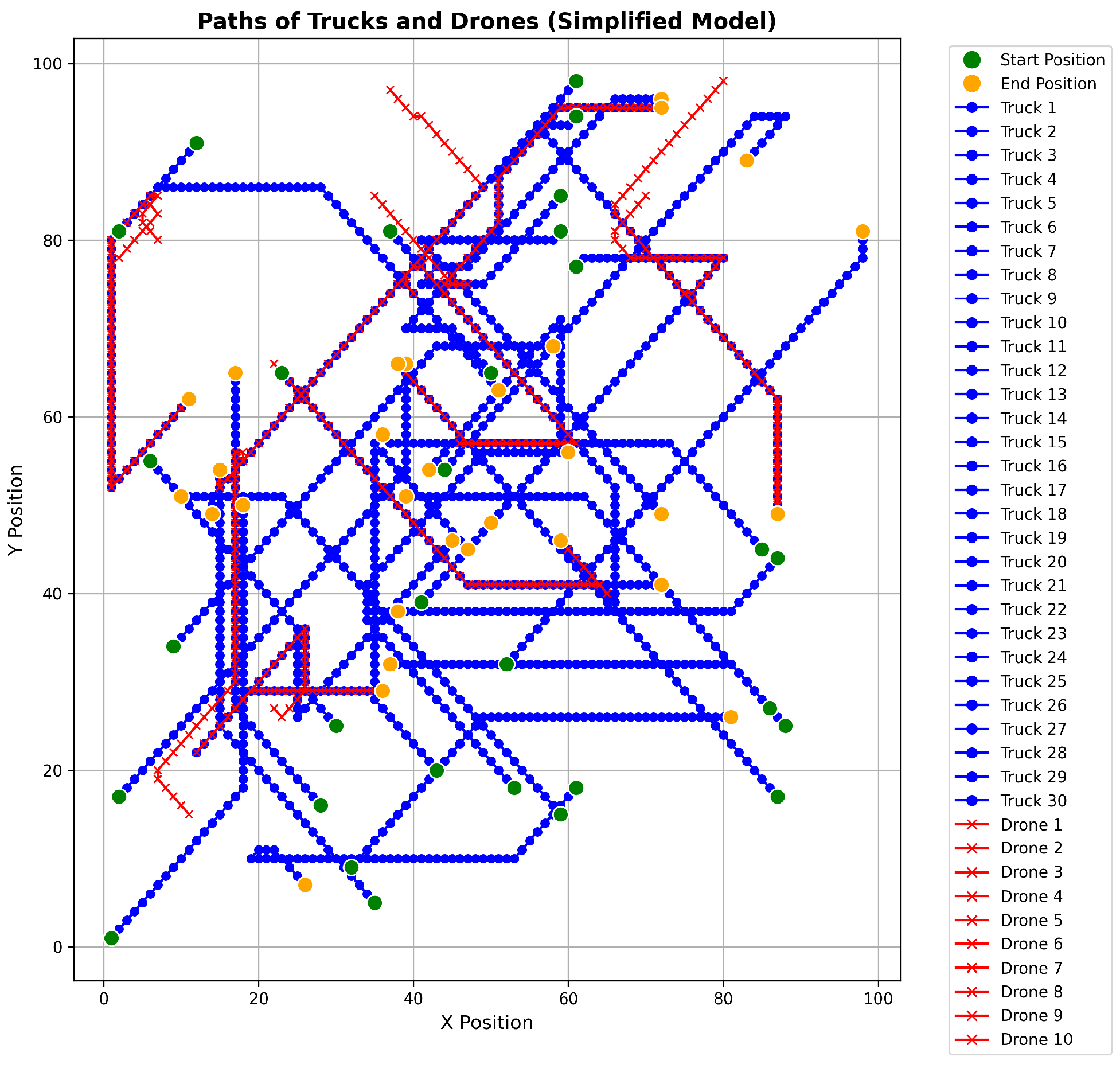
We begin with a simplified simulation, where the experiment aimed to simulate a scenario with trucks and drones to observe truck-platooning behavior and drone-following stability. Setup: The simulation involved 30 trucks and 10 drones on a 100 × 100 grid. Trucks moved toward random destinations, and drones followed the nearest truck.
Main Findings:
Truck Platooning: The trucks formed platoons with an average size of 2.53, demonstrating potential for fuel efficiency improvement.
Drone Following: The drones maintained an average distance of 1.39 units from the nearest truck, showcasing effective following behavior.
Stability: The drones were generally stable in following the trucks with an average of 1.6 nearest truck changes per drone.
This visualization in
Figure 3 provides insight into how the drones are able to follow the trucks and adapt to their movements over time.
Platooning Dynamics:
The trucks in the simplified model have exhibited platooning behavior throughout the simulation. On average, the size of the platoons (groups of trucks traveling closely together) was approximately 2.53 trucks per platoon.
A total of 243 platoons were identified over the 50 simulation steps.
Insights: The average platoon size indicates that trucks were often able to form small groups, demonstrating the potential for fuel efficiency improvement and increased road safety, which are key benefits of platooning. The total number of platoons formed suggests active dynamics in platoon formation and dissolution, indicating a responsive system to the changing positions of the trucks.
Proximity to Nearest Truck:
Average Distance: The drones were, on average, approximately 1.39 units away from the nearest truck. This indicates a relatively close proximity, suggesting effective following behavior.
Maximum Distance: The maximum observed distance between a drone and the nearest truck was approximately 14.56 units. This could be a moment where the drone was transitioning between trucks or when the trucks were widely spread out.
Minimum Distance: The minimum observed distance was 0.0 units, meaning there were instances where a drone was exactly at the same position as a truck, showcasing precise following capability.
Standard Deviation: The standard deviation of the distances was approximately 2.87, indicating some variability in the drones’ proximity to the trucks.
Insights: The drones in the simplified model demonstrated an ability to closely follow the trucks, maintaining a generally low average distance to the nearest truck. The variability in distances suggests that there were moments of both very close proximity and relatively farther distances, which could be areas for improvement.
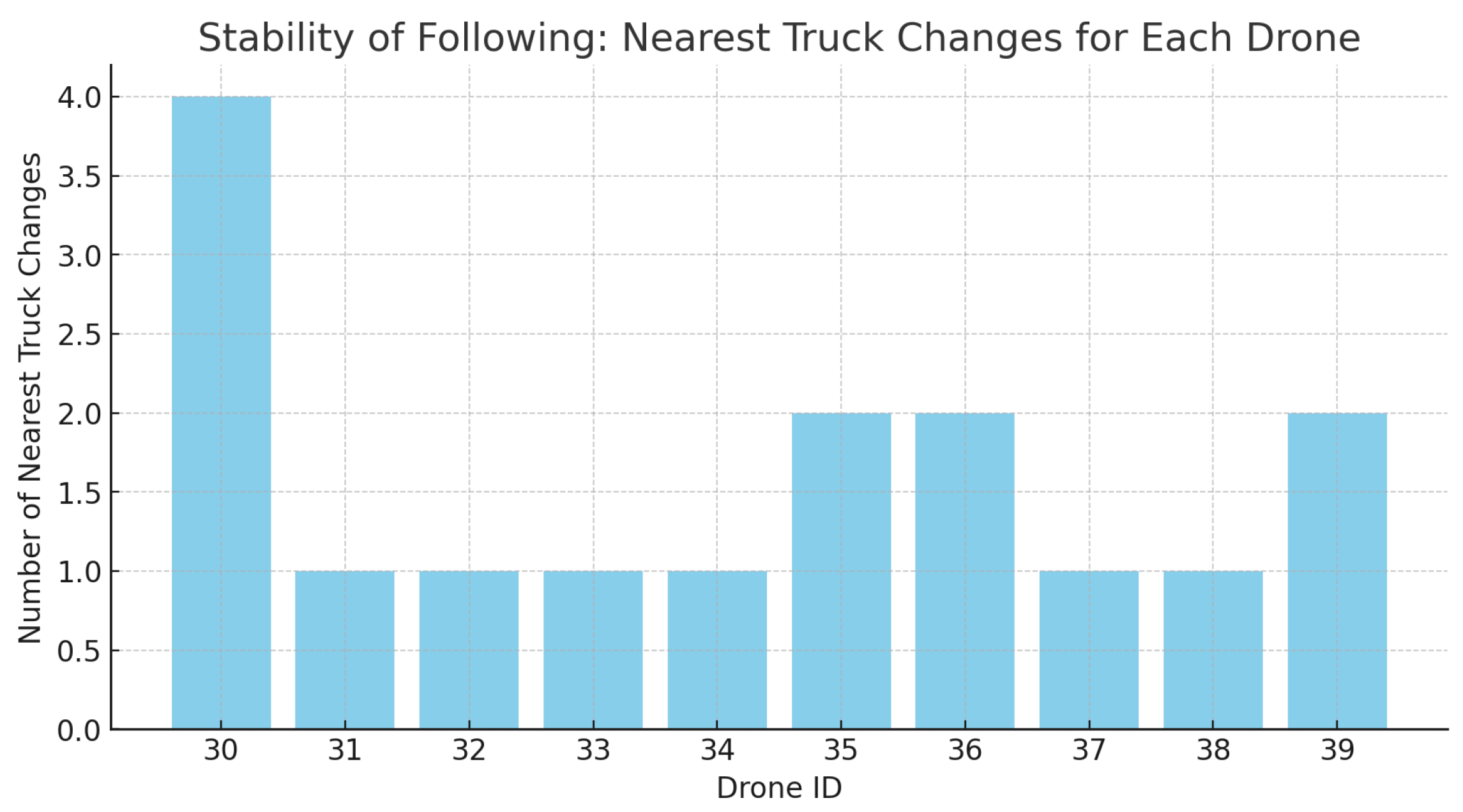
Nearest Truck Changes:
Average Changes: On average, each drone changed its nearest truck approximately 1.6 times throughout the simulation.
Maximum Changes: The maximum number of nearest truck changes for a single drone was 4.
Minimum Changes: The minimum number of nearest truck changes was 1.
Insights: The relatively low average number of nearest truck changes suggests that the drones were fairly stable in following the trucks. However, there is some variability, with certain drones changing their nearest truck more frequently than others. This could be due to the dynamic movement of the trucks and the positioning of the drones.
In the bar plot in
Figure 4, you can see the number of nearest truck changes for each drone throughout the 50 simulation steps. The drones are labeled with their IDs, ranging from 30 to 39.
Observations: Most drones have a relatively low number of nearest truck changes, indicating stable following behavior. However, Drone 30 stands out with four nearest truck changes, which is the maximum observed in this simulation. This could be a result of its initial position, movement pattern, or the dynamics of the nearby trucks. Interpretation: A lower number of nearest truck changes suggests that the drone is able to consistently follow a particular truck, which is a desirable behavior for applications such as aerial monitoring or assistance in platooning. On the other hand, a higher number of changes could indicate instability in following or could be a result of the drone effectively adapting to the changing positions of multiple trucks.
The plot in
Figure 5 shows the number of truck platoons formed at each time step.The green line represents the number of platoons. The number of platoons varies over time, reflecting the dynamic nature of truck movements and platoon formations.
In the formulation of our truck and drone platooning model, dynamic stability is a primary consideration given the inherent risks associated with the oscillatory modes of a multi-dimensional system. The simplified simulation model incorporates rudimentary movement patterns for trucks and drones, providing a foundational framework upon which stability controls can be built. In our simulations, we implement measures to mitigate the risk of dynamic instability. These include speed synchronization protocols to prevent abrupt relative speed changes and a following algorithm that enables drones to maintain a steady distance from the trucks, thereby providing corrective actions that are both proactive and reactive to the system’s state.
Next, we implement the fully fledged system. Here, trucks move around a grid, reporting distances to their nearest neighbor, while whole drones monitor the trucks, calculating the average distance between them, and maintaining platoons of trucks based on their proximity and compatibility. The simulation runs for 50 steps with 30 trucks and 10 drones in a 100 × 100 grid. After the simulation, it collects and visualizes data on the average distance between trucks and the number of platoons over time. The visualization of drone coverage is also generated, providing insight into how well the drones are able to monitor the trucks on the grid.
The simulation results demonstrate the effectiveness of our drone-based decentralized truck platooning system with UWB sensors. The multi-objective optimization successfully formed platoons based on the compatibility of trucks, resulting in reduced fuel consumption and travel time. The use of UWB sensors for distance measurement and platoon control significantly contributed to the system’s performance. The high accuracy and reliability of the UWB technology ensured that the drones could maintain the desired distance between trucks, preventing incidents and improving safety. Additionally, the UWB sensors enabled the drones to coordinate their positions and movements effectively, ensuring their safe operation within the system. An illustrative example of a particular instance of the simulation is shown in
Figure 6 where the number of platoons in operation decided by the controller as a result of the multi-objective optimization is six and the average distance between trucks maintained by the algorithm is 5.11.
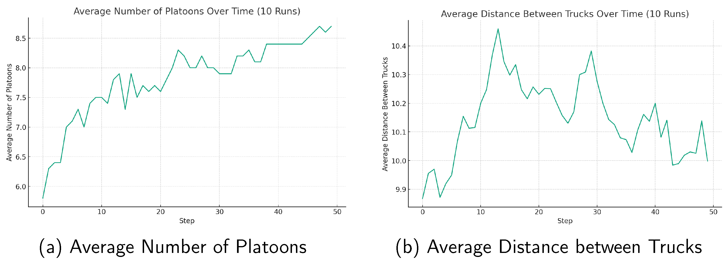
We simulated several runs of the drone-based platooning system and calculated the average results for number of platoons over time, see
Figure 7a, and the average distance between trucks over time, see
Figure 7b.
6.3. Simulation Analysis of Fuel Efficiency
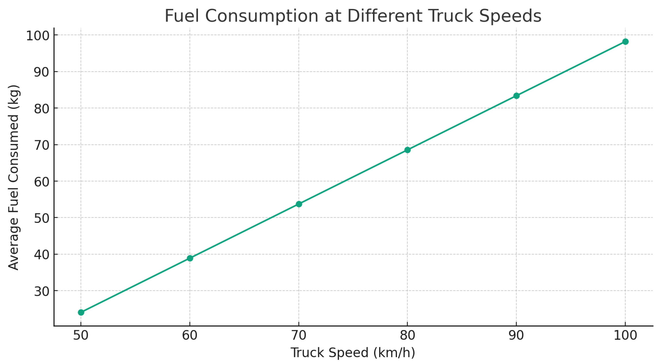
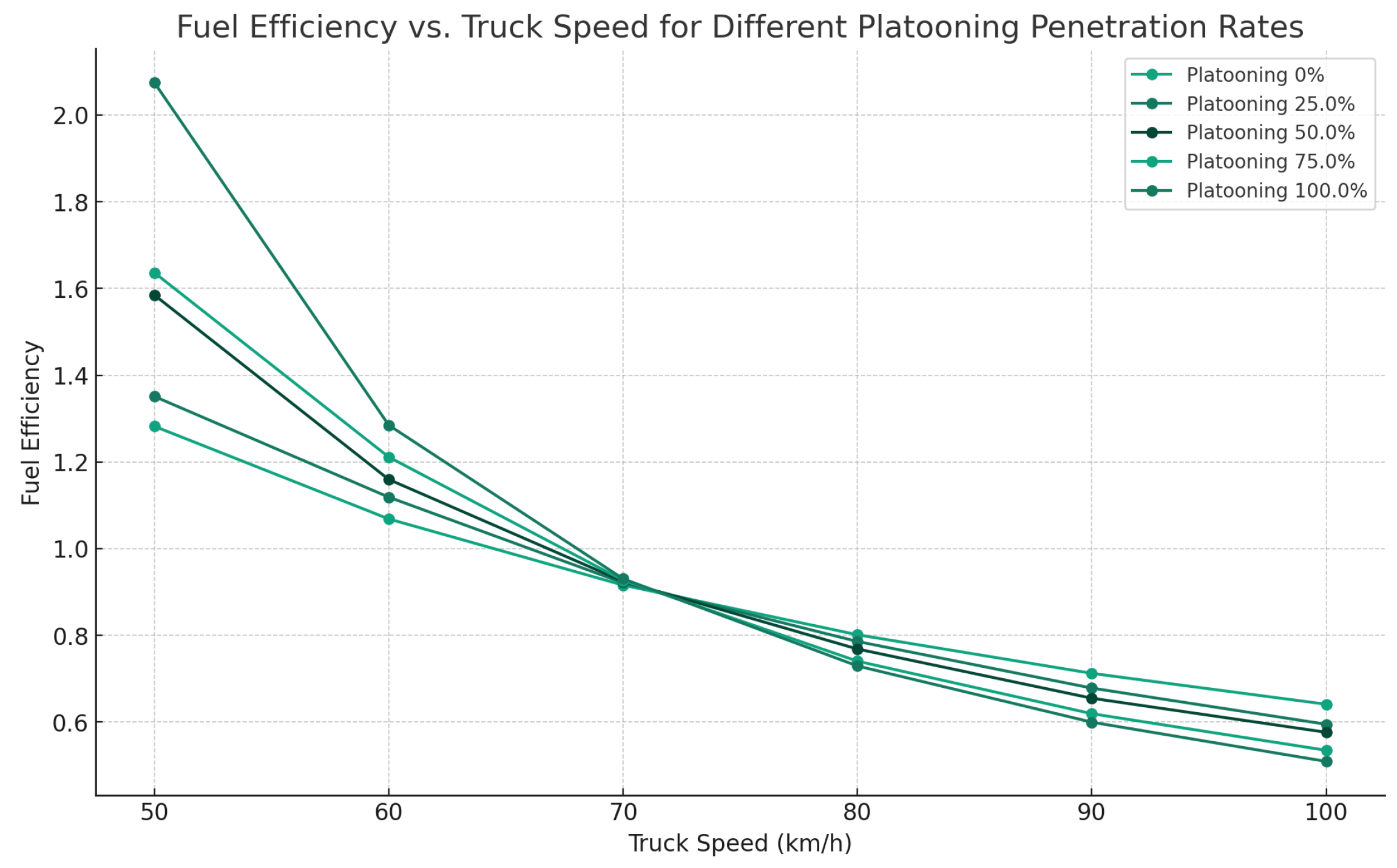
To investigate the impact of platooning on fuel efficiency, a simulation was conducted using a model that incorporates various factors such as truck speed, specific fuel consumption (SFC), and aerodynamic effects. The simulation involved 30 trucks over a virtual environment, with each truck moving toward a random destination and consuming fuel based on its speed and whether it was in a platoon. Two key scenarios were analyzed: (1) the average fuel consumed by trucks at different speeds without considering platooning effects, and (2) the fuel efficiency at different truck speeds for varying platooning penetration rates.
Figure 8 presents the results of the first scenario, illustrating the relationship between truck speed and average fuel consumption. As expected, fuel consumption increases with speed due to the higher power requirements for overcoming aerodynamic drag and rolling resistance.
Figure 9 shows the results of the second scenario, depicting how platooning penetration rates affect fuel efficiency. The graph indicates that higher platooning penetration rates lead to improved fuel efficiency across all speeds tested. This efficiency gain is attributed to the reduced aerodynamic drag when trucks travel in close formation, highlighting the benefits of platooning in reducing fuel consumption.
7. Conclusions and Future Work
In this paper, we have introduced an innovative drone-based decentralized truck platooning system leveraging UWB technology. This system is designed to ensure accurate distance estimation and enable the efficient formation of truck platoons. Our system utilizes a multi-objective optimization strategy to form and maintain platoons based on the compatibility of trucks. This approach is designed to optimize fuel efficiency, travel time, and safety in truck platooning systems. The use of UWB technology is a defining feature of our proposed system, providing highly accurate and reliable distance measurements between vehicles. Such precise measurements are essential for maintaining optimal distances in platooning formations, thereby preventing potential incidents and enhancing safety.
Moving forward, future work will focus on refining and extending the current system. Key areas for future exploration include the following: developing more advanced optimization techniques for efficient platoon formation, establishing reliable and secure communication protocols between drones and trucks, exploring the scalability of the proposed system in more complex scenarios, investigating possible integration with existing or future traffic management systems, and also conducting extensive real-world experiments to validate the system’s performance.
Further work could explore the following directions:
Enhanced algorithms: Investigate more advanced optimization techniques, such as genetic algorithms, reinforcement learning, or swarm intelligence, to further improve the process of formation of platoons and adapt to the dynamic environment.
Communication protocols: Develop reliable and secure communication protocols [
27] between drones and trucks to ensure the robustness and security of the platooning system against potential attacks and failures.
Scalability: Study the scalability of the proposed system by considering larger numbers of trucks and drones operating in more complex road networks and environments, including urban and rural settings.
Integration with traffic management systems: Investigate the integration of the proposed platooning system with existing or future traffic management systems to coordinate platoons’ movements with other road users and optimize the overall traffic flow.
Real-world testing: Conduct extensive real-world experiments to validate the performance of the proposed system in practical scenarios and identify potential challenges and limitations that may arise during deployment.


