GIS in Architectural Teaching and Research: Planning and Heritage
Abstract
:1. Introduction
2. GIS in Architecture Education and Research
3. The Role of GIS in Urban and Regional Planning
4. The Role of GIS in Architectural Heritage
5. Case Studies from Three European Universities
5.1. European Framework
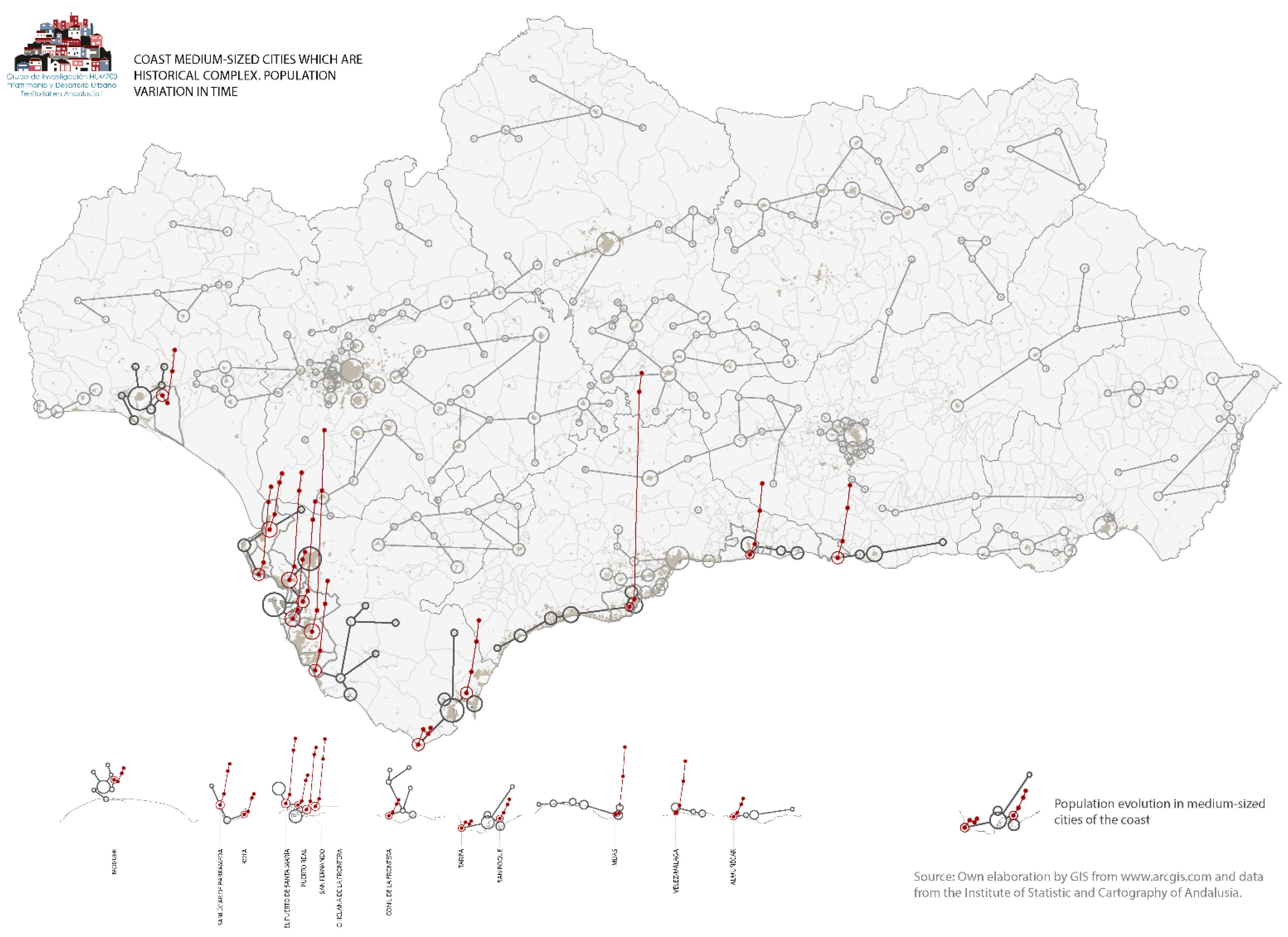
5.2. University of Seville
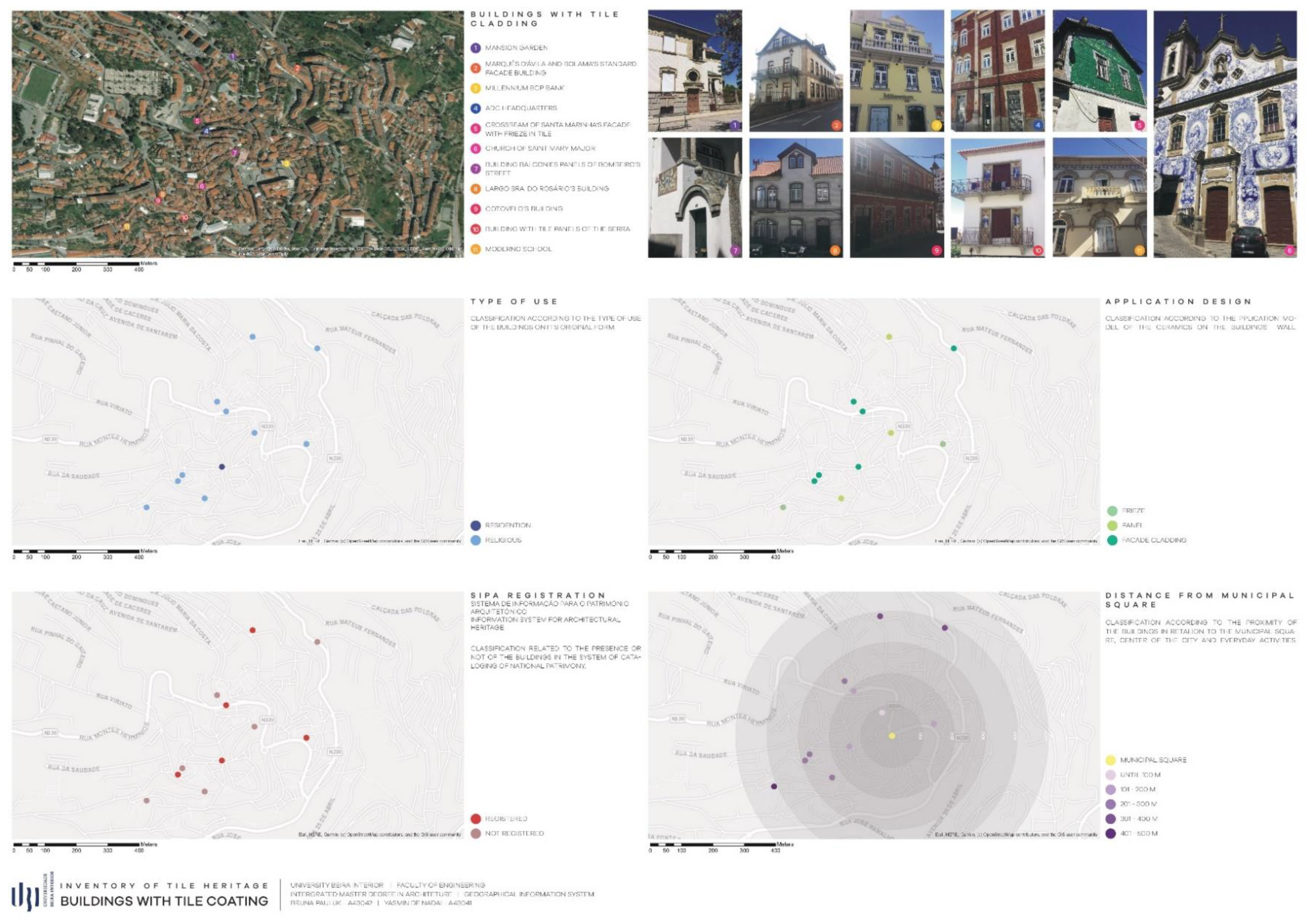
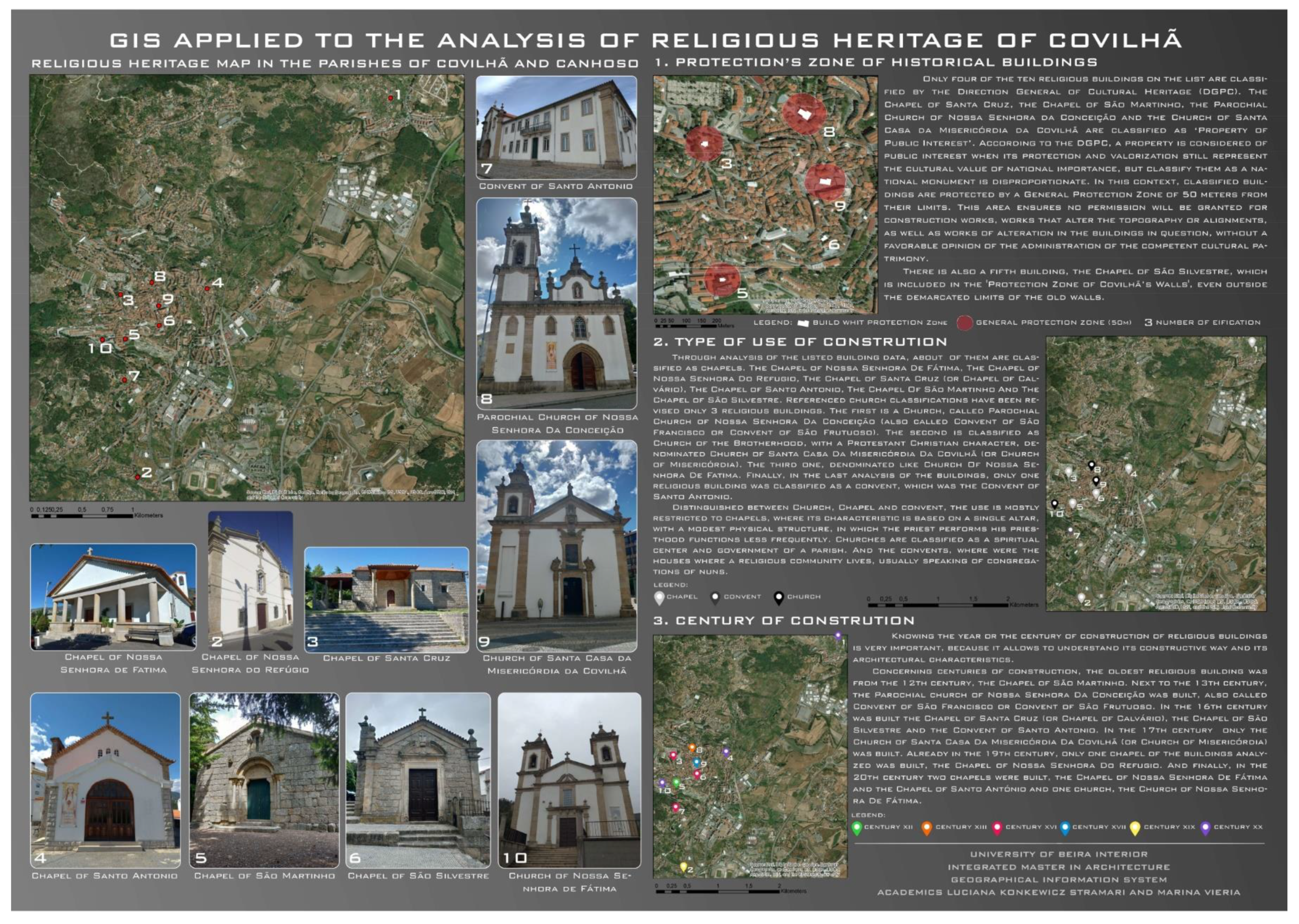
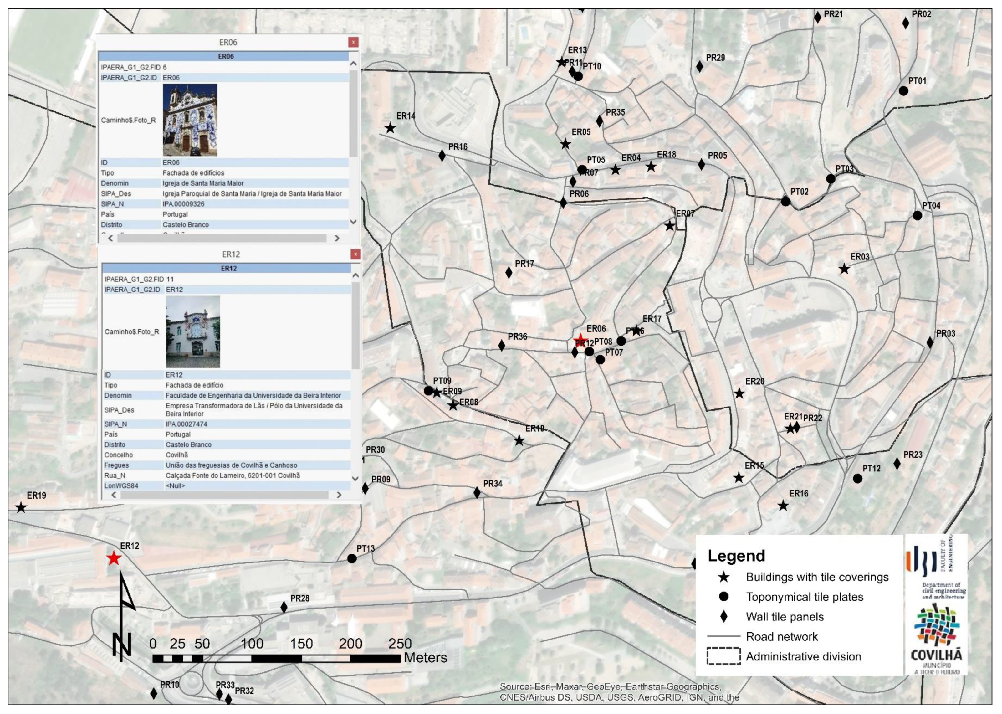
5.3. University of Beira Interior
5.4. Technical University of Crete
5.5. Findings
6. Conclusions
Author Contributions
Funding
Acknowledgments
Conflicts of Interest
References
- Drennon, C. Teaching Geographic Information Systems in a Problem- Based Learning Environment. J. Geogr. High. Educ. 2005, 29, 385–402. [Google Scholar] [CrossRef]
- Paradis, T.; Treml, M.; Manone, M. Geodesign Meets Curriculum Design: Integrating Geodesign Approaches into Undergraduate Programs. J. Urban. Int. Res. Placemaking Urban Sustain. 2013. [Google Scholar] [CrossRef]
- Monsur, M.; Zakiul, I. GIS for Architects: Exploring the Potentials of Incorporating GIS in Architecture Curriculum. ARCC Conf. Repos. 2014. [Google Scholar] [CrossRef]
- Puerto, F.P.; Fornos, R.A.; Román, M.C.; Dorado, J.A.; Lopes, P.F. Using BIM and GIS to Research and Teach Architecture. In Architectural Draughtsmanship; Perea, E.C., Valiente, E.E., Eds.; Springer: Berlin/Heidelberg, Germany, 2018. [Google Scholar] [CrossRef]
- Brunetaud, X.; De Luca, L.; Janvier-Badosa, S.; Beck, K.; Al-Mukhtar, M. Application of Digital Techniques in Monument Preservation. Eur. J. Environ. Civ. Eng. 2012, 16, 543–556. [Google Scholar] [CrossRef]
- Freire, G.J.d.M. Reinserimento Degli Spazi Urbani di Insediamenti Precari (Favelas) Mediante il GIS. Disegnarecon 2013, 6, 71–80. [Google Scholar] [CrossRef]
- Schulze, U.; Kanwischer, D.; Reudenbach, C. Essential Competences for GIS Learning in Higher Education: A Synthesis of International Curricular Documents in the GIS&T Domain. J. Geogr. High. Educ. 2013. [Google Scholar] [CrossRef]
- Sinton, D.S. Roles for GIS within Higher Education. J. Geogr. High. Educ. 2009. [Google Scholar] [CrossRef]
- Kim, M.; Bednarz, R. Development of Critical Spatial Thinking through GIS Learning. J. Geogr. High. Educ. 2013. [Google Scholar] [CrossRef]
- Hwang, S. Placing GIS in Sustainability Education. J. Geogr. High. Educ. 2013. [Google Scholar] [CrossRef]
- Summerby-Murray, R. Analysing Heritage Landscapes with Historical GIS: Contributions from Problem-Based Inquiry and Constructivist Pedagogy. J. Geogr. High. Educ. 2001, 25, 37–52. [Google Scholar] [CrossRef]
- Santos, B.; Martins, A.; Campos, I.; Gonçalves, J.; Almeida, P. When Past and Future Meet in Architecture Teaching: Heritage and GIS. In Proceedings of the ICERI 2018—11th annual International Conference of Education, Seville, Spain, 12–14 November 2018; pp. 902–910. [Google Scholar]
- Martins, A.; Gonçalves, J.; Santos, B.; Marques, S. Learning from the Historic City: Architectural Heritage Rehabilitation and GIS, The URS-VISEU NOVO (Portugal) Legacy. In Proceedings of the INTED 2019—13th International Technology Education and Development Conference, Valencia, Spain, 11–13 March 2019; pp. 8993–9001. [Google Scholar]
- Kara, L. A Critical Look at the Digital Technologies in Architectural Education: When, Where, and How? Procedia Soc. Behav. Sci. 2015, 176, 526–530. [Google Scholar] [CrossRef] [Green Version]
- Ferreira-Lopes, P. Achieving the State of Research Pertaining to GIS Applications for Cultural Heritage by a Systematic Literature Review. Int. Arch. Photogramm. Remote Sens. Spat. Inf. Sci. 2018, 42, 249–252. [Google Scholar] [CrossRef] [Green Version]
- Blišťan, P.; Kovanič, Ľ.; Kovaničová, M. The Importance of Geographic Information Systems Education at Universities in the Process of Building a European Knowledge-Based Society. Procedia Soc. Behav. Sci. 2015, 191, 2458–2462. [Google Scholar] [CrossRef] [Green Version]
- Wang, H.; Pan, Y.; Luo, X. Integration of BIM and GIS in Sustainable Built Environment: A Review and Bibliometric Analysis. Autom. Constr. 2019, 103, 41–52. [Google Scholar] [CrossRef]
- Karsli, F.; Ayhan, E.; Tunc, E. Building 3D Photo-Texture Model Integrated with GIS for Architectural Heritage Conservation. In Proceedings of the XIXth International Symposium, CIPA 2003: New perspectives to save cultural, Antalya, Turkey, 30 September–6 October 2003; pp. 144–147. [Google Scholar]
- Toz, G.; Duran, Z. Documentation and Analysis of Cultural Heritage by Photogrametric Methods and GIS: A Case Study. Int. Arch. Photogramm. Remote Sens. Spat. Inf. Sci. 2004, XXXV, 1–5. [Google Scholar]
- Droj, G. Cultural Heritage Conservation by GIS. In GISOPEN; Nyugat-Magyarországi Egyetem, Geoinformatikai Kar: Székesfehérvár, Hungary, 2010. [Google Scholar]
- Seker, D.Z.; Alkan, M.; Kutoglu, H.; Akcin, H.; Kahya, Y. Development of a GIS Based Information and Management System for Cultural Heritage Site; Case Study of Safranbolu. In Proceedings of the FIG—Fédération Internationale des Géomètres Congress, Sydney, Australia, 11–16 April 2010. No. 1–10. [Google Scholar]
- Portman, M.E.; Natapov, A.; Fisher-Gewirtzman, D. To go where no man has gone before: Virtual Reality in Architecture, Landscape Architecture and Environmental Planning. Comput. Environ. Urban Syst. 2015, 54, 376–384. [Google Scholar] [CrossRef]
- Pedro, J.; Silva, C.; Pinheiro, M.D. Integrating GIS Spatial Dimension into BREEAM Communities Sustainability Assessment to Support Urban Planning Policies, Lisbon Case Study. Land Use Policy 2019, 83, 424–434. [Google Scholar] [CrossRef]
- Dekolo, S.O.; Oduwaye, L. GIS in Urban and Regional Planning. In Proceedings of the Nigerian Institute of Town Planners CPD Workshop, Lagos, Nigeria, 1 January 2005. [Google Scholar] [CrossRef]
- Faludi, A. A Reader in Planning Theory, 1st ed.; Pergamon Press: Oxford, NY, USA, 1973. [Google Scholar]
- European Parliament and Council. I Directive 2007/2/EC of the European Parliament and of the Council of 14 March 2007 Establishing an Infrastructure for Spatial Information in the European Community (INSPIRE). Off. J. Eur. Union 2007, 50, 14. [Google Scholar]
- Stauskis, G. Development of Methods and Practices of Virtual Reality as a Tool for Participatory Urban Planning: A Case Study of Vilnius City as an example for improving Environmental, Social and Energy Sustainability. Energy. Sustain. Soc. 2014. [Google Scholar] [CrossRef] [Green Version]
- LeGates, R.T. Competency-Based UK Urban Spatial Planning Education. J. Educ. Built Environ. 2009, 4, 55–73. [Google Scholar] [CrossRef]
- Martín, M. Sobre El necesario vínculo entre el Patrimonio y La Sociedad. Reflexiones críticas sobre la interpretación del Patrimonio. Estud. Património 2001, 1, 25–37. [Google Scholar]
- Ripp, M.; Rodwell, D. The Geography of Urban Heritage. Hist. Environ. Policy Pract. 2015. [Google Scholar] [CrossRef]
- Martins, A.; Carlos, J. The Re-Use(s) of a Cistercian Monastery in Lisbon. ACEE J. Archit. Civ. Eng. Environ. 2013, 6, 45–60. [Google Scholar]
- Martins, A.; Pérez-Cano, M.T.; Mosquera-Adell, E. Monastic Buildings: A review about new uses on former Monasteries. The Portuguese Cistercian case. IOP Conf. Ser. Mater. Sci. Eng. 2019, 471, 082037. [Google Scholar] [CrossRef]
- Torsello, B.P. Proyecto, conservación, innovación. Loggia 1999, 8, 10–17. [Google Scholar] [CrossRef] [Green Version]
- Martins, A.; Carlos, J.; Nepomuceno, M. Built Heritage Research and Education. In Proceedings of the EDULEARN 18–9th International Conference on Education and New Learning Technologies, Palma de Mallorca, Spain, 3–5 July 2017; pp. 10268–10277. [Google Scholar] [CrossRef]
- Mine, T.Z. Adaptive Re-Use of Monuments: Restoring Religious Buildings with Different Uses. J. Cult. Herit. 2013, 14, S14–S19. [Google Scholar] [CrossRef]
- Ferreira-Lopes, P.; Pinto-Puerto, F. GIS and Graph Models for Social, Temporal and Spatial Digital Analysis in Heritage: The Case-Study of Ancient Kingdom of Seville Late Gothic Production. Digit. Appl. Archaeol. Cult. Herit. 2018. [Google Scholar] [CrossRef]
- Caputo, P.; Pasetti, G. GIS Tools towards a renovation of the Building Heritage. Energy Procedia 2017, 133, 435–443. [Google Scholar] [CrossRef]
- Saygi, G.; Remondino, F. Management of Architectural Heritage Information in BIM and GIS: State-of-the-Art and Future Perspectives. Int. J. Herit. Digit. Era 2013, 2, 695–713. [Google Scholar] [CrossRef] [Green Version]
- Cano, M.; Garzón, E.; Sánchez-Soto, P.J. Historic Preservation, GIS, & Rural Development: The Case of Almería Province, Spain. Appl. Geogr. 2013, 42, 34–47. [Google Scholar] [CrossRef]
- Navas-Carrillo, D.; Hidalgo, B.D.E.; Navarro-De Pablos, F.J.; Cano, M.T.P. The Urban Heritage Characterization Using 3D Geographic Information Systems. The System of Medium-Sized Cities in Andalusia. Int. Arch. Photogramm. Remote Sens. Spat. Inf. Sci. ISPRS Arch. 2018, 42, 127–134. [Google Scholar] [CrossRef] [Green Version]
- Nogueira, T.D.; Laboratorio di Geoprocessing. Disegno e Gestione dell’ Occupazione Territoriale com il Supporto del Telerilevamento e dei Sistemi Informativi Geografici—Bassi Costi e Grandi Benefici in Brasile. Disegnarecon 2013, 6, 49–60. [Google Scholar] [CrossRef]
- Petronela, S.; Adrian, U.; Ion, S. Heritage Management using GIS. In Proceedings of the 16th International Multidisciplinary Scientific GeoConference SGEM, Albena, Bulgaria, 30 June–6 July 2016; pp. 263–270. [Google Scholar]
- Lafreniere, D.; Weidner, L.; Trepal, D.; Scarlett, S.F.; Arnold, J.; Pastel, R.; Williams, R. Public Participatory Historical GIS. Hist. Methods J. Quant. Interdiscip. Hist. 2019, 52, 132–149. [Google Scholar] [CrossRef]
- Fabbri, K.; Zuppiroli, M.; Ambrogio, K. Heritage Buildings and Energy Performance: Mapping with GIS Tools. Energy Build. 2012, 48, 137–145. [Google Scholar] [CrossRef]
- Buffat, R.; Schmid, L.; Heeren, N.; Froemelt, A.; Raubal, M.; Hellweg, S. GIS-Based Decision Support System for Building Retrofit. Energy Procedia 2017, 122, 403–408. [Google Scholar] [CrossRef]
- Oppio, A.; Bottero, M.; Ferretti, V.; Fratesi, U.; Ponzini, D.; Pracchi, V. Giving Space to Multicriteria Analysis for Complex Cultural Heritage Systems: The Case of the Castles in Valle D’Aosta Region, Italy. J. Cult. Herit. 2015, 16, 779–789. [Google Scholar] [CrossRef]
- Husseini, B.; Bali, Z. Documentation, Using GIS Techniques in Conservation of a World Heritage Site, a Case Study of “the Old City of Jerusalem”. In Proceedings of the International Archives Photogrammetry Remote Sensing Spatial Information Science—ISPRS Archives 25th International CIPA Symposium, Taipei, Taiwan, 31 August–4 September 2015; Volume 40, pp. 229–234. [Google Scholar] [CrossRef] [Green Version]
- Lianos, N.; Stamnas, A. A Recording and Documentation System of Building Stock: The Case of Pentalofos Settlement in Kozani (Greece). In Proceedings of the 8th International Congress in Archaeology, Computer Graphics, Cultural Heritage and Innovation—ARQUEOLÓGICA 2.0, Valencia, Spain, 5–7 September 2016; pp. 89–94. [Google Scholar] [CrossRef] [Green Version]
- Santos, B.; Gonçalves, J.; Martins, A.; Almeida, P. Safeguarding Portuguese Traditional Glazed Tile Cultural Heritage with GIS. IOP Conf. Ser. Mater. Sci. Eng. 2020, 949, 012071. [Google Scholar] [CrossRef]
- Pérez-Cano, M.T.; Prieto, J.; Adell, E.; Jiménez, C.; Naranjo, M.; Fuentes, D. Caracterizacion Urbano Patrimonial y Modelo Turistico Cultural en Ciudades Medias. Potencialidades y Retos para su Internacionalizacion: Betica Interior. Available online: http://institucional.us.es/innerbaetica/index.html (accessed on 11 January 2021).
- Rodríguez-Lora, J. La Protección Del Patrimonio Contemporáneo. Arquitectura En Torno Al Movimiento Moderno En Sevilla. Una Revisión Urbano-Patrimonial Tres Décadas Después. Master’s Thesis, Universidad de Sevilla, Sevilla, Spain, 2018. [Google Scholar]
- Chatzigrigoriou, P.; Mavrikas, E. Saving Historic Buildings with Multi-Criteria GIS Tool: The Case of Hermoupolis—Cyclades. In Proceedings of the 2013 Digital Heritage International Congress (DigitalHeritage), Marseille, France, 28 October–1 November 2013; Volume 2, pp. 53–59. [Google Scholar] [CrossRef]
- Bushmakina, Y.V.; Balyberdina, P.A.; Dmitrieva, M.K.; Gogoleva, M.V. The Use of GIS for Studying Cultural Heritage and Historical Urban Landscape: The Case of Perm and Usolie (Russia). Ge-Conservación 2017, 1, 264–271. [Google Scholar] [CrossRef]
- Almeida, V. Valores Urbanos e Património na Definição de Princípios de Intervenção: O Centro Histórico de Viseu. Mestrado em Reabilitação Urbana. Ph.D. Thesis, Universidade de Coimbra, Coimbra, Portugal, 2017. [Google Scholar]
- Pérez-Cano, M.T. Medium-Sized Cities of Inner Baetica. In Catálogo exposición IMPACT-Ciudades Medias de la Bética Interior; Pérez-Cano, M.T., Ed.; HUM700-Patrimonio y Desarrollo Urbano Territorial en Andalucía: Sevilla, Spain, 2019; ISBN 978-84-09-17265-8. [Google Scholar]
- Ministerio de Educación. Disposición 12269 Del BOE Núm. 185; 2010; Available online: https://www.boe.es/boe/dias/2010/07/31/pdfs/BOE-A-2010-12269.pdf (accessed on 11 January 2021).
- Albourae, A.T.; Armenakis, C.; Kyan, M. Architectural Heritage Visualization using Interactive Technologies. Int. Arch. Photogramm. Remote Sens. Spat. Inf. Sci. 2017, 42, 7–13. [Google Scholar] [CrossRef] [Green Version]
- Martins, A.; Girão, J.; Rosado, A. La Internacionalización de la Investigación en Patrimonio. Resultados y Experiencias. In Proceedings of the XV Foro Internacional Sobre la Evaluación de la Calidad de la Investigación y de la Educación Superior—FECIES, Granada, Spain, 10–12 May 2018. [Google Scholar]
- Martins, A.; Mosquera-Adell, E.; Pérez-Cano, M.T.; Royo-Naranjo, L.; Aladro-Prieto, J. Built Heritage Research and Education: Iberian Experience. In Proceedings of the ICERI2018—11th Annual International Conference of Education, Research and Innovation Proc., Seville, Spain, 12–14 November 2018; pp. 2382–2387. [Google Scholar] [CrossRef]
- Domínguez Ruiz, V. Aplicación de los Sistemas de Información Geográfica (SIG) al Proyecto de Rehabilitación Arquitectónica y Urbana. Ph.D. Thesis, Universidad de Sevilla, Sevilla, Spain, 2016. [Google Scholar]
- Martins, A. As Arquitecturas de Cister em Portugal. A Actualidade das Suas Reabilitações e a Sua Inserção No Território. Ph.D. Thesis, Universidad de Sevilla, Sevilla, Spain, 2011. [Google Scholar]
- Sánchez Jiménez, F.J. Estudio Histórico-Técnico de los Molinos Hidráulicos de Alcalá de Guadaíra. Ph.D. Thesis, Universidad de Sevilla, Sevilla, Spain, 2015. [Google Scholar]
- Mascort-Albea, E.J. Mapas para el Patrimonio: Caracterización Técnica de Las Iglesias Medievales de Sevilla Mediante Sistemas de Información Geográfica (SIG). Ph.D. Thesis, Universidad de Sevilla, Sevilla, Spain, 2018. [Google Scholar]
- Guia Digital Instituto Andaluz del Patriminio Histórico (IAPH). Available online: https://guiadigital.iaph.es/ (accessed on 17 July 2019).
- Processo ACEF/0910/26421 Do Ciclo de Estudos Em Arquitectura; Covilhã, Portugal, 2012; Available online: https://www.ugr.es/~aepc/FECIES_16/LIBROCAPITULOXIII.pdf (accessed on 11 January 2021).
- Martins, A. Curriculum Design: History of Portuguese Architecture and the Integrated Master Degree in Architecture. In Proceedings of the INTED 2018—12th International Technology, Education and Development Conference, Valencia, Spain, 5–7 March 2018; pp. 530–535. [Google Scholar] [CrossRef]
- Martins, A. Portuguese Cistercian Heritage Research and Architectural Education. Heritage 2016, 2, 1139–1146. [Google Scholar]
- Barrows, H.S. A Taxonomy of Problem-based Learning Methods. Med. Educ. 1986, 20, 481–486. [Google Scholar] [CrossRef] [PubMed]
- Garcia-Almirall, M.P.; Redondo Domínguez, E.; Valls Dalmau, F.; Corso Sarmiento, J.M. Experiencia Docente en la enseñanza de Sistemas de Información Geográfica en Arquitectura. In Proceedings of the 9th Iberian Conference on Information Systems and Technologies (CISTI), Barcelona, Spain, 18–21 June 2014; pp. 407–412. [Google Scholar] [CrossRef]
- Bearman, N.; Jones, N.; André, I.; Cachinho, H.A.; DeMers, M. The Future Role of GIS Education in Creating Critical Spatial Thinkers. J. Geogr. High. Educ. 2016. [Google Scholar] [CrossRef]
| Geoportal | Level | Territorial Coverage | Web Link (All Accessed on January 11 2021) |
|---|---|---|---|
| IDEE—Spatial Data Infrastructure (SDI) of Spain | National | Spain | https://www.idee.es/web/guest |
| IDEEX—Extremadura Spatial Data Infrastructure | Regional | Extremadura (Spain) | http://ideextremadura.com/Geoportal/ |
| IDE Sevilla—Spatial Data Infrastructure of Sevilla | Municipal | Seville (Spain) | https://sig.urbanismosevilla.org/ |
| SNIG—National Geographic Information System | National | Portugal | https://snig.dgterritorio.gov.pt/ |
| SIG—Regional Portal of Médio Tejo | Regional | Médio Tejo Region (Portugal) | https://mediotejo.pt/index.php/sig-public |
| Geodados—Lisbon City Council Platform | Municipal | Lisbon (Portugal) | http://geodados.cm-lisboa.pt/ |
| Geoportal—Covilhã City Council | Municipal | Covilhã (Portugal) | http://plantasonline.cm-covilha.pt/ |
| Geodata—Open geospatial data and services for Greece | National | Greece | https://geodata.gov.gr/ |
| e-ΠOΛΕOΔOΜΙA—Electronic urban planning GIS | National | Greece | http://gis.epoleodomia.gov.gr/ |
| WebGIS—Thessaloniki | Municipal | Thessaloniki (Greece) | https://gis.thessaloniki.gr/ |
| WebGIS—Heraklion | Municipal | Heraklion (Greece) | http://gis.heraklion.gr/ |
| Field of Research | Source |
|---|---|
| Built heritage and energy efficiency | [37,44,45] |
| Architectural cultural heritage conservation and management (e.g., castles, religious heritage, historical buildings, settlements) | [4,18,19,20,36,42,46,47,48,49] |
| Traditional rural buildings | [39,50] |
| Contemporary heritage | [51] |
| City heritage management | [13,47,52,53,54,55] |
| QS—Quacquarelli Symonds World University Rankings | THE—Times Higher Education World University Rankings | ||
|---|---|---|---|
| Indicators | Weight | Indicators | Weight |
| Academic Reputation | 40% | Teaching (the learning environment) | 30% |
| Employer Reputation | 10% | Research (volume, income and reputation) | 30% |
| Faculty/Student Ratio | 20% | Citations (research influence) | 30% |
| Citations per Faculty | 20% | International Outlook (staff, students and research) | 7.5% |
| International Faculty Ratio | 5% | Industry Income (knowledge transfer) | 2.5% |
| International Student Ratio | 5% | ||
| QS—Quacquarelli Symonds World University Rankings | |||
|---|---|---|---|
| Rank | University | Status | Country |
| 1 | UCL (University College London) | Public | UK |
| 2 | Delft University of Technology (Technische Universiteit Delft) | Public | Netherlands |
| 3 | ETH Zurich—Swiss Federal Institute of Technology in Zurich (Eidgenössische Technische Hochschule Zürich) | Public | Switzerland |
| 4 | University of Cambridge | Public | UK |
| 5 | Manchester School of Architecture | Public | UK |
| 6 | Politecnico di Milano | Public | Italy |
| 7 | EPFL Federal Institute of Technology in Lausanne (École Polytechnique Fédérale de Lausanne) | Public | Switzerland |
| 8 | The University of Sheffield | Public | UK |
| 9 | KTH Royal Institute of Technology (Kungliga Tekniska högskolan) | Public | Sweden |
| 10 | Technical University of Munich (Technische Universität München) | Public | Germany |
| THE—Times Higher Education Rankings | |||
| Rank | University | Status | Country |
| 1 | University of Cambridge | Public | UK |
| 2 | ETH Zurich—Swiss Federal Institute of Technology in Zurich (Eidgenössische Technische Hochschule Zürich) | Public | Switzerland |
| 3 | UCL (University College London) | Public | UK |
| 4 | University of Edinburgh | Public | UK |
| 5 | EPFL Federal Institute of Technology in Lausanne (École Polytechnique Fédérale de Lausanne) | Public | Switzerland |
| 6 | Technical University of Munich (Technische Universität München) | Public | Germany |
| 7 | KU Leuven (Katholieke Universiteit Leuven) | Public | Belgium |
| 8 | Delft University of Technology (Technische Universiteit Delft) | Public | Netherlands |
| 9 | RWTH Aachen University (Rheinisch-Westfälische Technische Hochschule Aachen) | Public | Germany |
| 10 | University of Glasgow | Public | UK |
| University | GIS Courses/Use |
|---|---|
| UCL | Bachelor: Elective GIS course, use of GIS (in compulsory courses) Master: Use of GIS (in compulsory and elective courses and research) Doctorate: Use of GIS (lab and research) |
| ETH Zurich | Bachelor: Use of GIS (in elective courses) Master: Use of GIS (in elective courses) Doctorate: Use of GIS (research) |
| University of Cambridge | Bachelor: No course Master: No course Doctorate: Use of GIS |
| Delft University of Technology | Bachelor: * Master: Elective GIS course, use of GIS (in compulsory courses). Other masters of the Faculty of Architecture and the Built Environment with important GIS content: 1. Geomatics (compulsory and elective courses) 2. Geographical Information Management and Application (compulsory courses) Doctorate: Use of GIS (research) |
| EPFL | Bachelor: Use of GIS (in compulsory courses) Master: Use of GIS (in compulsory and elective courses) Doctorate: * |
| University | GIS Courses/Use |
|---|---|
| University of Seville | Bachelor: No course (GIS-related compulsory and elective courses in pre-Bologna programme—use of GIS) Master: Use of GIS (research), day dedicated to the use of GIS Doctorate: Use of GIS (research) |
| University of Beira Interior | Bachelor: Compulsory GIS course Master: Use of GIS (research) Doctorate: - |
| Technical University of Crete | Bachelor: Compulsory-elective GIS course Master: - Doctorate: - |
Publisher’s Note: MDPI stays neutral with regard to jurisdictional claims in published maps and institutional affiliations. |
© 2021 by the authors. Licensee MDPI, Basel, Switzerland. This article is an open access article distributed under the terms and conditions of the Creative Commons Attribution (CC BY) license (https://creativecommons.org/licenses/by/4.0/).
Share and Cite
Santos, B.; Gonçalves, J.; Martins, A.M.; Pérez-Cano, M.T.; Mosquera-Adell, E.; Dimelli, D.; Lagarias, A.; Almeida, P.G. GIS in Architectural Teaching and Research: Planning and Heritage. Educ. Sci. 2021, 11, 307. https://doi.org/10.3390/educsci11060307
Santos B, Gonçalves J, Martins AM, Pérez-Cano MT, Mosquera-Adell E, Dimelli D, Lagarias A, Almeida PG. GIS in Architectural Teaching and Research: Planning and Heritage. Education Sciences. 2021; 11(6):307. https://doi.org/10.3390/educsci11060307
Chicago/Turabian StyleSantos, Bertha, Jorge Gonçalves, Ana M. Martins, Maria T. Pérez-Cano, Eduardo Mosquera-Adell, Despina Dimelli, Apostolos Lagarias, and Pedro G. Almeida. 2021. "GIS in Architectural Teaching and Research: Planning and Heritage" Education Sciences 11, no. 6: 307. https://doi.org/10.3390/educsci11060307
APA StyleSantos, B., Gonçalves, J., Martins, A. M., Pérez-Cano, M. T., Mosquera-Adell, E., Dimelli, D., Lagarias, A., & Almeida, P. G. (2021). GIS in Architectural Teaching and Research: Planning and Heritage. Education Sciences, 11(6), 307. https://doi.org/10.3390/educsci11060307


