1. Introduction
Landscape is a concept with numerous meanings that is generally used as a hinge element and a transversal axis to articulate concepts of both natural and social sciences. Landscape represents a powerful connection between geography and other Earth sciences, since it allows us to analyse the different layers that make up the environment [
1]. Landscape could be defined as a recognizable part of the Earth’s surface, with its own physiognomy consisting of a complex network of systems that result from the activity and interplay of rocks, water, air, plants, animals, and humans. A more accurate definition of the landscape is provided by the European Landscape Convention (ELC) [
2] (p. 2): “landscape means an area, as perceived by people, whose character is the result of the action and interaction of natural and/or human factors”. This is a holistic definition, including all kinds of landscapes, without differentiating between natural or human landscapes. The definition of the ELC has been progressively ratified by different European countries and its acceptance has a number of implications: for example, the convention underlines the importance of the landscape to society as it contributes to human well-being and promotes the connection of cultural identities with their territory [
2]. Briefly, the ECL adopts a holistic view that includes four elements of sustainable development: nature, culture, society, and economy [
3].
Geologists and physical geographers have a similar definition of landscape and use it for describing geomorphologic features encountered in a certain environment [
4]. These natural landscapes are molded by different surficial processes acting over different timescales, from millions of years to days, and thus register the evolution of the surface of the Earth over time. From an educational point of view, in the sense of Lacreu’s geological landscape [
5], they can be used as an educational resource and as an object of study in itself. According to the author, the adjective “geological” of landscape highlights the elements that can provide information to understand the history of the relief and landscape of an area, even to differentiate between natural and anthropized reliefs.
To analyse the landscape, it is necessary to perform an act of reflection prior to the description. From an educational point of view, a proper analysis of the landscape must include a practical approach that allows hands-on experiences [
1]. Geographers have been working on landscape interpretation for decades, and recently some interesting proposals for working with physical landscapes have been published that include both practical and theoretical approaches to understand its evolution [
6,
7,
8]. In order to transform a resource into an object or problem to be solved by the students, a series of questions on the origin and geological evolution of the landscape could be promoted: Were landforms and their materials always there? How and when were they formed? To answer these questions, it is undoubtedly necessary to have a minimum mastery of the concept of geological or deep time and the great magnitudes of time that it entails.
Physical landscapes are dynamic constructs, in continuous evolution, integrated by a set of elements both visible and non-visible, characterized by being manifest, observable, perceptible. In fact, the above definition of the ELC puts an emphasis on the perceptual dimension of the landscape. The landscape thus can be redefined as “a way of seeing” rather than a scene or an image of the Earth’s surface [
9]. Landscapes are both materially and perceptually constructed [
10]. Perception of the physical environment is influenced by the individual’s experiences, and social, educational, and cultural factors. Landscapes can be perceived with several senses, but sight undoubtedly plays a key role. Therefore, it is evident that visual perception depends, among other factors, on the observers and their individual background. However, a proper perception and cognition of physical landscapes cannot be accomplished solely through direct view and individual construction but must be acquired with the help of explanations and exposure to scientific and culturally accepted information. In this sense, it can be suggested that a person who wears certain “scientific glasses” will be able to better perceive, understand, analyse, and assess an observed landscape. That is, where an untrained eye sees mainly the beauty of a scene, a trained person goes a step further, trying to answer how, when, and why such a natural scene has come into being and, most important, will reflect further on the importance of its preservation [
11].
The present study stems from the idea that if someone is aware of the time elapsed since the formation and the relief of a certain landscape that he or she is observing, that person will have a better understanding of all the processes involved in landscape formation, as well as the need to preserve it. In fact, landscape practices over an area should start with the determination of geomorphological factors, which always leads to a better understanding and ability to evaluate the entire landscape, its components, and the characteristics of each component [
12]. In this sense, some authors stated that [
4] (p. 173): “geologists use landscapes as analogues for past environments and relate observed processes in modern landscape (e.g., erosion, or sedimentation) to past processes according to actualistic approaches. Thus, their process-oriented approach requires the development of a four-dimensional view on landscapes looking not only at the surface and the depths below, but also back in time”.
Understanding the geologic time (both the relative and absolute time) is fundamental to make sense of the geological factors and processes [
13]. Therefore, to properly percept and understand the origin and evolution of natural landscapes, it is necessary to manage the time scales of the different processes involved, both the external ones, such as weathering and erosion, and the internal ones, such as orogenesis. This study explores people’s conceptions of geological time and its relation to landscape formation, and more precisely focuses on how Spanish geology students and pre-service teachers perceive the frequency and rate of a number of geological processes that have shaped the history of our planet and that are involved in the formation of the current relief.
1.1. Landscape and Education
The ECL encourages the importance of the landscape in the education system. There is a specific point for “training and education” where the ELC indicates that countries should promote “school and university courses which, in the relevant subject areas, address the values attaching to landscapes and the issues raised by their protection, management and planning” [
2] (p. 3). The idea behind the text is to promote landscape education within society in order to increase the knowledge about this issue. Then, this knowledge should qualify citizens to participate, in an adequate way, in making decisions about landscape conservation and landscape management [
14].
Specifically, in Spain landscape education is taught in different ways during all educational levels, and different methodologies can be used depending on the characteristics of the students [
15,
16,
17]. During compulsory education, most of the contents related to landscape are included in social and natural sciences subjects, where students start analysing natural landscapes and then anthropized landscapes, reinforcing the idea of the interdependence between nature and human activities.
Nowadays, environmental education, including natural landscapes, is needed, as most people, especially secondary students, imagine the environment as an idyllic natural landscape where most of its elements are of natural origin, such as mountains, water, or flora [
18]. Environmental education should include the importance of landscapes within the context of natural sciences, but also in the context of social sciences, promoting holistic learning that involves the head (knowledge), the heart (emotions), and the hand (skills). In addition, teaching students the basic concepts of landscape formation and evolution will lead to a better understanding of the environmental risks imposed on these landscapes and the need to preserve them, and this will promote public participation in decision-making [
19,
20].
1.2. Geologic Time and Natural Landscape Evolution
Many fundamental natural phenomena occur on extreme time scales that humans cannot experience directly. This is also the case for relief and landscape formation and evolution. But other geological phenomena—for example, volcanic eruptions—occur on a human time scale. In order to understand all these natural phenomena, it is necessary to manage the abstract concept of geologic time (or deep time) and adopt a geologic perspective, taking into consideration that some natural elements have been created over long periods of time under conditions that are impossible to reproduce in a human lifetime scale.
The strong relation between landscape formation and geological time works in both directions, and relief and surficial landscape formation processes provide an excellent framework to understand geologic time and rates as students can imagine how long-term and gradual processes like erosion and deposition shape their surroundings. An appropriate comprehension of geologic time is necessary not only to interpret the relief or the landscape but also to understand key concepts in other areas of geoscience. For example, it is important to link deep time with the dynamic model for geologic change over time because both are the basis of Earth Sciences Literacy [
21]. In short, geologic time is a key concept to properly understand the theories of evolution [
22,
23], plate tectonics theory as a paradigm of modern geology [
24], anthropic influence on climate change or the key events in geologic history that include both absolute and relative ages [
25,
26].
Unfortunately, the ability to think across geologic time scales is difficult for many students, from elementary to undergraduate. The understanding of geologic time requires an ability to deal not only with the large magnitude of time involved but also with the temporal scales of events that occur across deep time [
27]. In recent years, in an attempt to identify the main difficulties that students have when managing the concept of geologic time, most research has focused on identifying their conceptions in different contexts and at different educational levels [
28]. These studies reveal four main conclusions: (1) students have trouble identifying and establishing the correct order of key events that have occurred throughout the geological and biological history and tend to mix and overlap some of them; (2) even when the events are spread widely apart from each other in time, students tend to find it difficult to associate them with specific absolute ages; (3) students do not usually relate geologic time elapsed with the appropriate orders of magnitude; and (4) they find it very hard to understand and assimilate the rates and duration of many geologic processes. This last conclusion has played a key role during the design of our investigation as we intend to analyse the ideas on landscape formation of a group of pre-service teachers. Moreover, according to the literature, students tend to explain certain geological processes, especially the ones that occur over very long time scales, such as the origin of a great mountain, with disaster theories such as volcano eruptions, earthquakes, or floods. Difficulties also arise when working with mid-time spans (e.g., formation of valleys, alluvial fans, etc.) [
27,
28,
29].
It is very important to reflect on how long natural processes take to develop, especially if we think about sustainability, climate change, consumption of resources, loss of biodiversity, or even landscape protection [
30,
31]. Inclusively, some authors pointed out the importance of mastering geologic time to understand environmental, political, and economic issues related to the sustainability of our planet [
32].
In the same research that we mentioned previously, authors investigated the ideas of geology students about deep time [
27]. Their results showed that these students, who are supposed to be experts in this field, have difficulties estimating formation rates of landscapes that were formed in intermediate timespans, according to previous results [
33]. Another study carried out with college students of geology identified incomplete scientific conceptions about the process of canyon formation and the role of rivers in canyon formation [
34]. This is not a new issue as numerous studies that focus on the learning processes of the concept of geologic time have been published in science education [
35]. Here we found an interesting reflection because these researches were focused on geology university or pre-university students, and a new reflection arises for us: if geology university students had had problems working with the geologic time, what would happen with those students who studied social sciences or humanities? For example, what is the level of knowledge about landscape formation of future primary or early childhood education teachers, who will have to teach the first notions of landscape and the action and interaction of natural and/or human factors to future generations?
4. Results
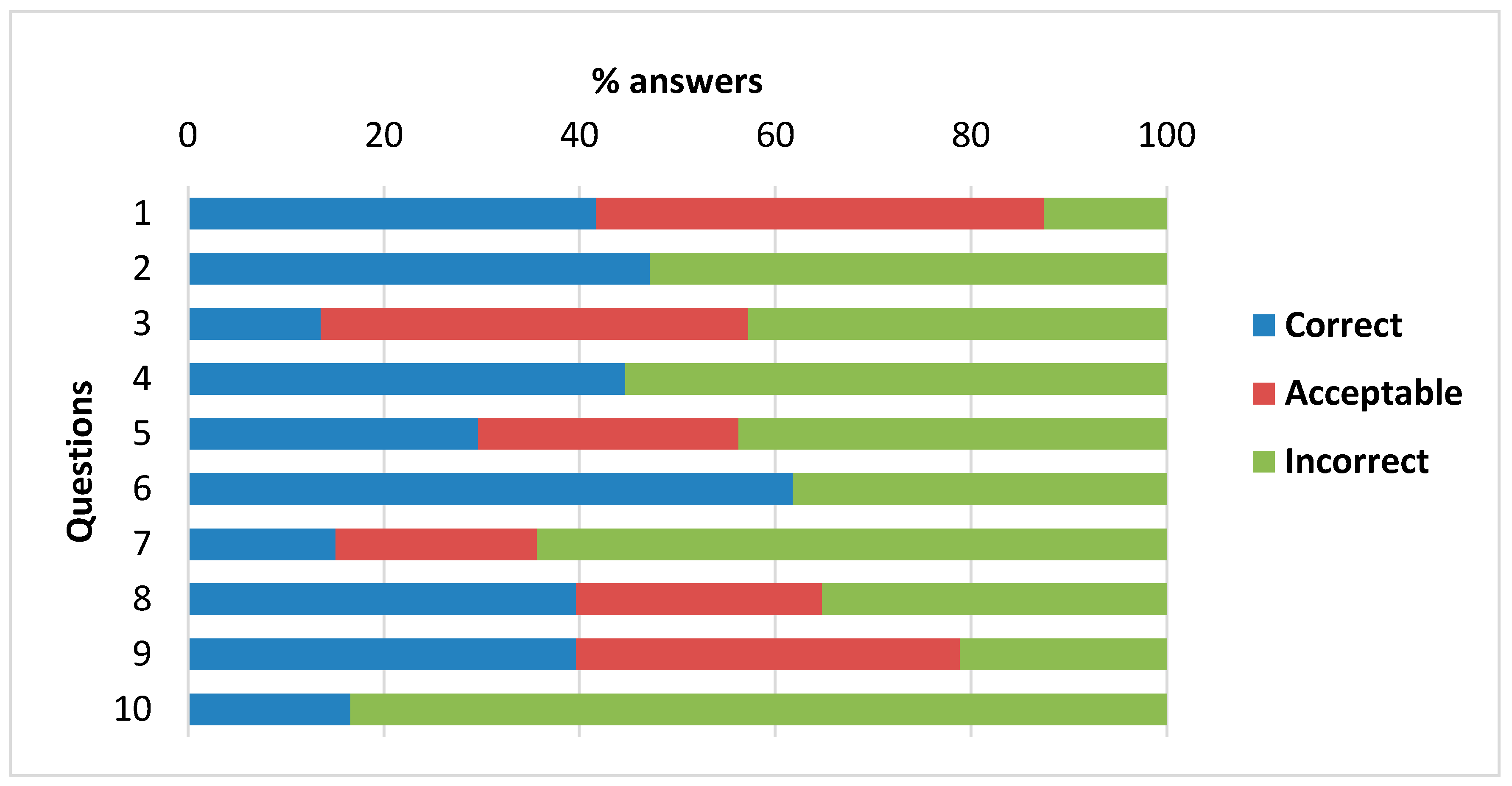
Figure 1 shows the percentage of answers of 199 students for each question included in the questionnaire (see
Appendix A). As can be seen, one of the most remarkable things was that only one question had more than 50% of correct answers (question 6). In addition, four of the questions had 30% of correct answers or less (questions 3, 5, 7, and 10). If we took into account the acceptable answers, percentages of wrong answers noticeably decreased, but only six questions obtained results with less than 50% of wrong answers. These results demonstrated an overall weak knowledge on landscape formation over geologic time, if we consider the complete sample of university students where education students were the majority. Nevertheless, we found remarkable differences between the components of this group, as will be explained later.
We differentiated two groups of questions in our questionnaire: on the one hand, we included questions about current relief (questions 1 to 6) and, on the other hand, there were questions about relief and landscapes throughout the history of the Earth (questions 7 to 10). For the first group of questions we registered an average percentage of 39.8% of correct answers, while for the second group we registered only 27.8%. However, if we took into account acceptable answers, the gap between both groups of questions suffered a significant reduction. Question 10 deserves specific attention because this question obtained the highest percentage of wrong answers. It is true that it was one of the questions without the possibility of acceptable answers, but it revealed the difficulty that students have with historical geology questions. In this question, students had to choose among various pictures (see
Appendix A) the image that best represented what the planet looked like when humans (hominids) first appeared. So, in order to answer this question correctly, students had to manage, on one hand, the time it took for the tectonic plates to move, and, on the other hand, the chronology of the appearance of the first human being.
In the next step of the analysis we disaggregated the data by university degree. We grouped the results according to students’ degrees: one group was composed of students of the early childhood education degree (n = 77), another group was composed of primary education degree students (n = 108), and the last one of geology degree students (n = 14). As we had different sample sizes, in order to know if homogeneity of variances was met by our data, Levene’s test was realized before the ANOVA analysis, obtaining a value of 0.202 for the Levene statistic based on mean, with a significance (p) of 0.962, and 0.24 based on median, with a significance of 0.944. As the significance in both cases was greater than 0.05, the null hypothesis of equal population variances was not rejected, and the ANOVA analysis could be performed. We eliminated four students from the general analysis (n = 199) due to their peculiar situation: one of them did not complete his baccalaureate, another one did a special baccalaureate branch, and two others took professional training before entering university.
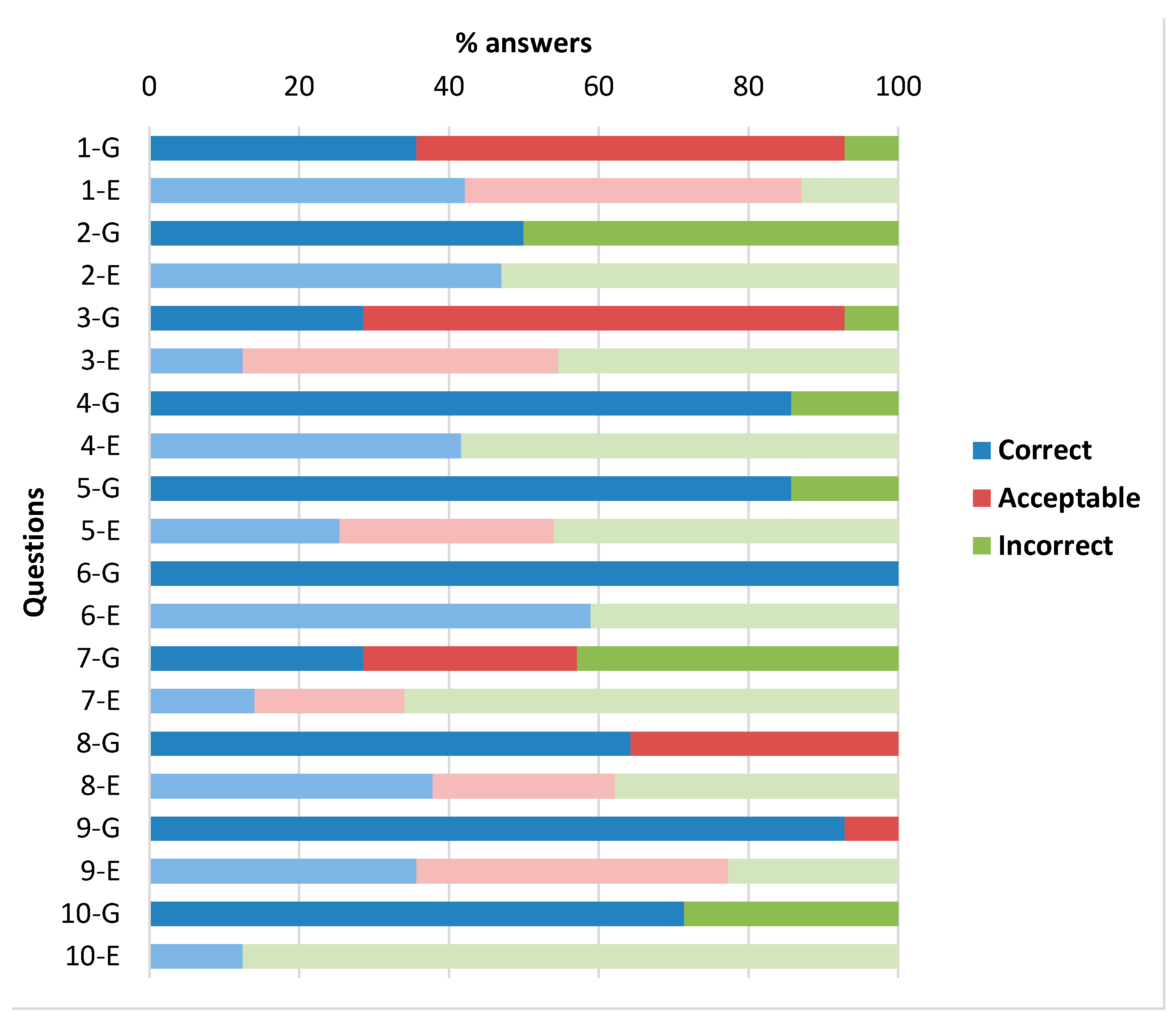
No significant differences were found between primary education and early childhood education students. So, we decided to group these students: in
Figure 2 geology students appear on one side, and all education students appear together on the other side. Overall, results showed a great disparity between the two groups of students: On the one hand, in contrast with previous papers [
21,
26], we observed relatively high scores among geology students and, on the other hand, low scores among education students. Remarkable differences were found between one group and another in terms of knowledge about landscape and relief and the duration of the processes involved: the average percentage of correct answers of geology students to the questionnaire was 64.3%, and the average percentage of correct answers of education students was 32.8%. We expected to find a high success rate among geology students and data collected confirm this assumption, but the low percentage of success rate among education students was remarkable.
If we divided the questions in two groups, as we did in the previous paragraphs, we observed that education students had great difficulties understanding historical geological questions. They obtained a percentage of correct answers of 25%, whereas geology students had 64.3% of correct answers. This big difference suggests that education students have noteworthy difficulties to understand the time it takes for continents to move and to form supercontinents. Again, we have to underline the answers to question 10: the percentage of correct answers of geology students was 71.4% and only 12.4% for education students. This big difference between the two groups of students in the questionnaire reinforced our previously suggested ideas.
When we analysed the questions related to the current relief we observed better results. Education students improved their rate of average correct questions and geology students maintained their scores (37.9% vs. 64.3%). Actually, in question nº 1 they obtained more correct answers than geology students. Education students understood erosive processes relatively well, and these results could be connected with their pre-university tuition. In order to probe deeper, we analysed the results, taking into consideration the branch they studied during their baccalaureate.
Table 2 shows the results of the study ordered according to the baccalaureate program that the students had attended and using the codification system described in the methodology epigraph (a student with 10 correct answers would obtain 20 points; a student with no correct answers would obtain 0 points).
Table 2 reveals that students with higher scores (mean = 13.4) were those who were enrolled in geology and took the scientific program during their baccalaureate. On the other hand, students with lower scores (mean = 6.0) were those who studied for education degrees and took the arts baccalaureate program.
One-way ANOVA indicated that there is a statistically significant difference in the mean scores between the different degrees and branches taken during the baccalaureate (F(4190) = 18.218,
p < 0.000). A Tukey post hoc test revealed that there is a statistically significant difference (
p < 0.000) in the mean scores between the students who were studying for a bachelor’s degree in geology (and took the science and technology high school program) and students who were studying for a bachelor’s degree in education and took the high school branches of science, arts, humanities and social sciences, and the group of students who unfortunately did not report their pre-university studies. However, there were no significant differences between the groups of students from the different education degrees. That is, future education teachers who had studied in the science program did not show significant differences in their mean scores compared to students who had studied in the humanities and social sciences or the arts branches. Nevertheless, there were some interesting results. More specifically, we identified noteworthy differences among education students according to their baccalaureate. According to expectations, education students who completed a scientific pre-university formation obtained higher scores than those who completed a humanistic and social formation (39.8% of correct answers vs. 31.3%), and those, in turn, obtained better scores than students who completed an artistic pre-university formation (25% of correct answers) (see
Table 3).
One surprising thing was the observed differences among students who studied scientific pre-university courses. Specifically, all geology university students (n = 14) completed this high school tuition and also a group of education students (n = 41), but when we analysed the percentage of correct answers of these two groups, we identified better rates among geology university students. The existence of optional courses called “Biology and Geology” or “Geology” during their pre-university scientific formation could explain this observation. It is likely that students who were thinking about undertaking university geologic studies would have chosen the courses related to geology and, on the other hand, those who were thinking about undertaking social university studies, such as primary education, would have chosen other optional courses. No information on these choices was collected in this research but this could play a role in this remarkable difference.
5. Discussion and Implications
This study reports the ideas of university students who were studying for bachelors’ degrees in early childhood education, in primary education, and in geology about the time involved in landscape and relief formation processes. Since data were collected during the first days of class of the first year of their degree, the results represented the students’ pre-university knowledge on the topic. In general terms, geology students had conceptions close to the scientific model, while education students’ ideas on the duration and frequency of the processes involved were incorrect. This outcome is surprising because, theoretically, all students who finish their secondary and compulsory studies should have learned the basic geosciences concepts needed to answer questions such as, for example, the timescale of some environmental problems and natural phenomena. In other countries, such as the United States, the National Science Education Standards recommend that at the end of primary education, students should develop an understanding of Earth history and of the fundamental principles of stratigraphy, including a basic understanding of uniformitarianism and catastrophism. Students at this age should also be introduced to scales and rates of Earth processes ranging from seconds (e.g., volcanic explosions) to tens of millions of years (e.g., the erosion of a mountain range) [
38,
39].
According to our data, baccalaureate branch seems to be a factor that could, at least partially, explain the differences in the knowledge of physical landscape formation processes among the four groups of students. Moreover, information on the subjects that students completed during their baccalaureate could provide even more profound insights into some interesting results, such as the differences observed among students who completed the scientific branch. These differences could be related to the set of subjects they studied. In the Spanish autonomous region where we conducted our study, Castille and Leon, every baccalaureate branch has three types of courses: general core subjects that are common for every single student, specific core branch subjects for each one of the branches (sciences, social sciences, and humanities, arts, etc.) and elective subjects. Among these two last type of subjects, each educational centre offers a different set of subjects, and students choose among these subjects in their baccalaureate. However, this information was not included in this study and a possible relation between the subjects offered in the scientific branch and the knowledge on landscape formation could not be demonstrated. In future investigations it would be interesting to include this information in order to clarify this relationship.
If we consider the baccalaureate studies, geology students who participated in this investigation studied in the technology and science branch during baccalaureate and, thus, probably took several elective subjects related to Earth and environmental sciences. In contrast, many of the early childhood education or primary education degree students took other branches during baccalaureate and, thus, have not worked these subjects of study since secondary education (12–16 years). The question, therefore, is whether the training that students receive during compulsory education about this important concept is sufficient or not to have a general view of how nature works and the duration of the processes that take place in it. As stated before, basic concepts on landscape and its formation are crucial to understand environmental, political, and economic issues related to the sustainability of our planet [
32]. Themes of geologic time and rates permeate the Earth Science Literacy Principles, which are a set of big ideas that experts feel citizens should know to make informed decisions on societal challenges requiring geoscientific understanding and solutions.
The vast majority of pre-service teachers studied a humanities and social sciences tuition during their baccalaureate. In the Spanish autonomous region where we carried out our research, Castille and Leon, during this period there was an optional course of geography in the last year. In this course, some units were dedicated to landscape and relief formation, highlighting the importance of geologic heritage and including the relationship between nature and human beings. So, despite the fact that students who attended the branches of social sciences and humanities obtained worse scores than students who took science and technology, those who did not take the geography optional course during the last year of this period may not have worked on landscape and relief formation since they were 15–16 years old. This fact could play a role in explaining the differences found between pre-service teachers who studied this branch and those who took an arts branch during their high school years.
These results are not surprising if we analyse the Spanish secondary education science curricula in general, and geoscience curricula in particular. In Spain [
40]: (1) scientific education receives very little attention in secondary education; (2) geosciences receive less attention than other scientific disciplines; and (3) geoscience contents are usually worked less in the classroom than they should be if taken into consideration of the official programs, and thus are treated in a very superficial and decontextualized way. There is also a lack of didactic and epistemological coherence in curricular designs and school texts due to the fact that the Spanish geology curriculum is outdated and, consequently, it is not capable of generating interest among students and teachers. Because of this, the geology curriculum receives less attention in the classroom, which could finally incentivize the educational administration to reduce its presence even further. Another problem of the Spanish science curriculum in secondary education is that its extension makes it practically impossible to work all the topics contained in it in depth [
41]. Finally, teachers are usually poorly trained in sciences contents, and particularly in geoscience contents, and this is reflected in their teaching [
41]. In the case of landscape and geologic time, certain previous studies argue that in-service teachers do not feel quite confident when it comes to teaching the concept of geologic time, since they lack the didactic skills and understanding of the subject [
42,
43].
Results show that, apparently, pre-service teachers have difficulties in mastering mid-time magnitudes. For example, they have significant difficulties in differentiating between the time that tectonic plates take to move around the planet and the appearance of humans (hundreds of millions of years vs. few millions of years). As also noticed in previous studies, these answers also imply that the students do not conceive that humans have been on Earth for a relatively short time, and therefore they resort to the idea of large continents that occurred in the past [
28,
44]. As a matter of fact, other authors have also demonstrated that one common student belief is that humans first appeared when the Earth had a single continent [
45].
The results obtained in this investigation are consistent with other research that also demonstrates that students have difficulties with scales and absolute values [
44,
46]. In addition, other researches found that university students have difficulties with the ages of the most recent events, like the last glaciation and the appearance of the human being [
27,
28], something that has also been observed in this study. This lack of knowledge is especially worrying if we consider that we are talking about future teachers, since they will shape children’s first ideas about deep time and landscape formation (it seems clear that to teach geologic time and relief formation, teachers will need to have minimal knowledge about this issue). It is true that these students can continue to improve their skills during their university degree, but nowadays, university pre-service teachers’ tuition is mainly oriented towards how to teach and, to a much lesser extent, to the contents that need to be taught. To teach the importance of abiotic systems in relief building properly it would be necessary to manage geologic contents and geologic learning strategies and, apparently, students who were enrolled in a bachelor’s degree in early childhood education and in primary education do not have the necessary skills.
One of the main problems to solve is that in Spain the vast majority of pre-service teachers took their last course of geology at the age of 15, during secondary education. As mentioned before, the only possibility to review the concepts of the physical landscape and geologic time for students who studied humanities and social sciences in high school was to do an optional course of geography in their last year of high school. So, with the current structure of the Spanish curriculum, geology teachers should highlight some key ideas about relief formation during secondary education, in order to improve scientific literacy and to allow a lifelong learning. Some authors have pointed out that it would be a good idea to introduce geologic concepts to help students to reconstruct the history of the Earth by studying rocks, their changes over the time, and their distribution in a tridimensional space [
47]. But this strategy requires new methodological proposals that go beyond the traditional teaching of conceptual and procedural geological contents. In order to make the contents related to landscape and geologic time attractive for teachers and students, we should find more appealing approaches that motivate teachers and students to work these contents more exhaustively [
6]. For example, connecting the consequences of climate change to the possible negative impacts in some of the most beautiful landscapes would allow us to link concepts of geologic time with currently ongoing environmental problems. Other authors propose to restructure the way that Earth sciences are taught during primary and secondary education, including, for example, exercises about the construction of the geologic history of the landscape next to schools [
48]. Other authors have demonstrated that students who participated in classroom activities (laboratory activities, small group discussions, written assignments, etc.) had better results in geosciences than those who only read and discussed the units during theoretical lessons [
49]. Given the results of our study, we suggest that it could be interesting to reinforce fieldwork sessions during compulsory education in order to consolidate the ideas about the formation of the current relief and, more specifically, those ideas related to historical geology. In fact, previous research has demonstrated that fieldwork has a positive impact on the teaching and learning of surficial processes and their effects on landscape formation [
29], as other authors have before when they designed a lesson on Earth history, including a field trip and hands-on activities [
50].
Finally, this research presents some limitations. To start with, the sample used in this research is not representative of the entire population of Spanish pre-service teachers. However, this study did allow us to compare our results with other studies that used a similar approach. We could not obtain general conclusions, so we had to interpret the results with prudence. Future work should seek to replicate our findings in other Spanish or European regions in order to corroborate our conclusions. It would have been interesting to have more accurate information about courses that students took during their high school years, in order to elucidate their influence on pre-service teachers’ knowledge. Despite these limitations, this research contributes to the existing literature about students’ knowledge of physical landscape formation processes, and more specifically, has allowed us to obtain new information about the level of knowledge about geological time that pre-service teachers have.

 ,
, 


