
Comparison of Multiple Maximum and Minimum Temperature Datasets at Local Level: The Case Study of North Horr Sub-County, Kenya

 , , , ,
Abstract
1. Introduction
2. Materials and Methods
2.1. Study Area
2.2. Historical Temperature Series
2.3. Reanalysis Product Description
- The ten-day dataset from the Kenyan Meteorological Department (referred to as KMD), with a resolution of 0.0375° [24], available at: http://kmddl.meteo.go.ke:8081/SOURCES/.KMD/ (accessed on 16 November 2020);
- Era-Interim reanalysis (referred as ERA), with a spatial resolution of 0.125° [33], available at: https://www.ecmwf.int/en/forecasts/datasets/reanalysis-datasets/era-interim (accessed on 16 November 2020);
- Climate Limited Area Model (CCLM) driven by HadGEM2-ES (referred to as HAD), with a spatial resolution of 0.1° [34], available at: https://climate4impact.eu/impactportal/data/esgfsearch.jsp (accessed on 16 November 2020);
- Observational Reanalysis Hybrid (referred as ORH), with a spatial resolution of 0.25° [35], available at: https://hydrology.princeton.edu/getdata.php?dataid=6 (accessed on 20 March 2021)
2.4. Methodology
- 1.
- Dataset performance assessment through the comparison between the historical observations of the land-based meteorological stations of Lodwar, Marsabit and Moyale and the dataset point values;
- 2.
- Evaluation of systematic errors in TMAX and TMIN seasonal representation of the chosen datasets at the land-based meteorological station level;
- 3.
- Calculation and validation of the monthly ranges of TMAX and TMIN for Lodwar, Marsabit and Moyale;
- 4.
- Calculation of the monthly reference values and ranges of TMAX and TMIN for all the eight reference points;
- 5.
- Validation of the results through the comparison between monthly TMAX and TMIN ranges and the observations recorded by the North Horr automatic land-based weather station.
2.4.1. Dataset Performance Comparison
2.4.2. Systematic Error Evaluation at Land-Based Station Level
2.4.3. Reference Values and Range Computation and Validation at Land-Based Station Level
2.4.4. Range Computation at Reference Point Level
2.4.5. Result Validation for North Horr
3. Results and Discussion
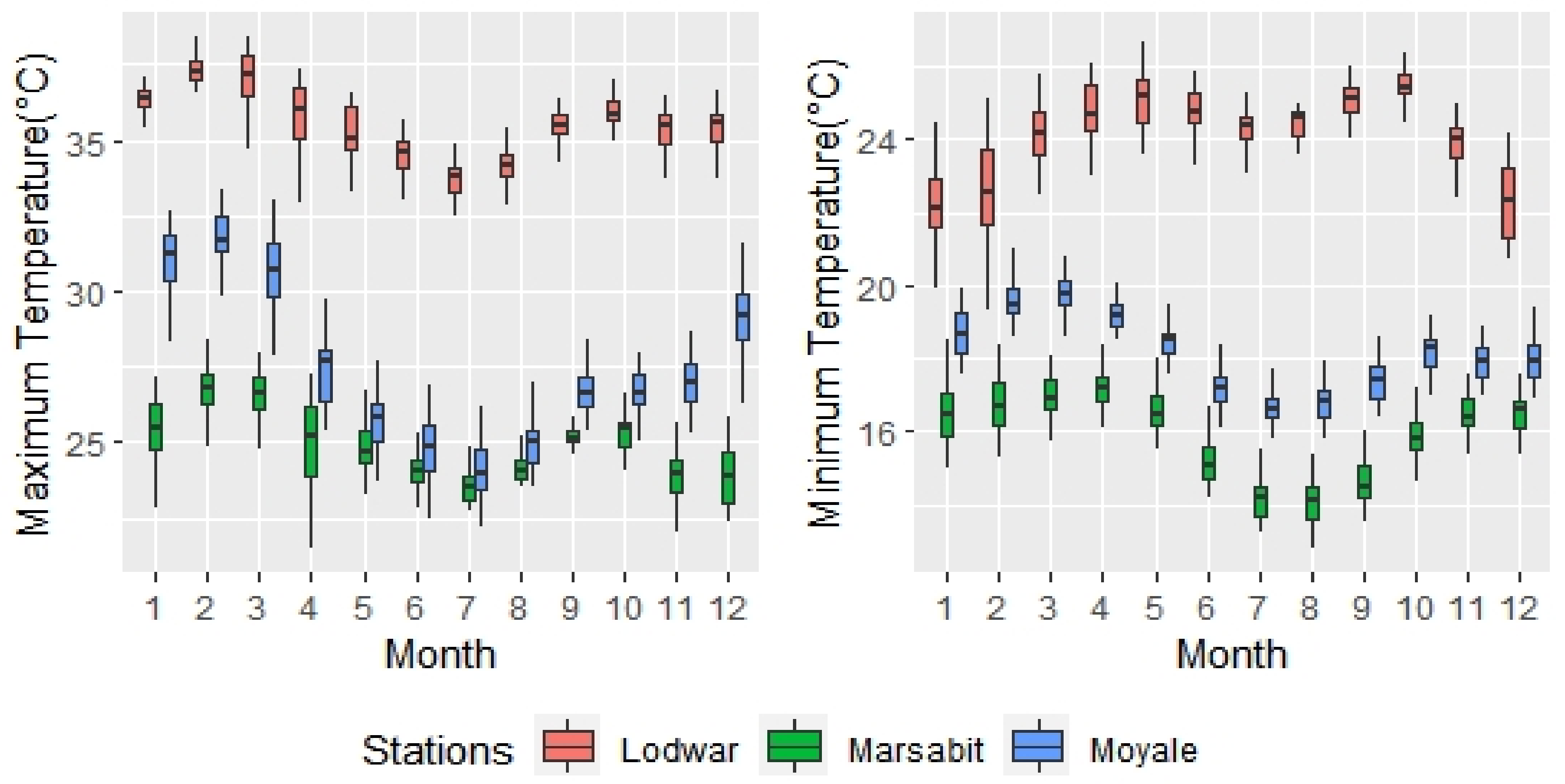
3.1. Dataset Performance Comparison
3.2. Systematic Error Evaluation at Land-Based Station Level
3.3. Reference Values and Range Computation and Validation at Land-Based Station Level
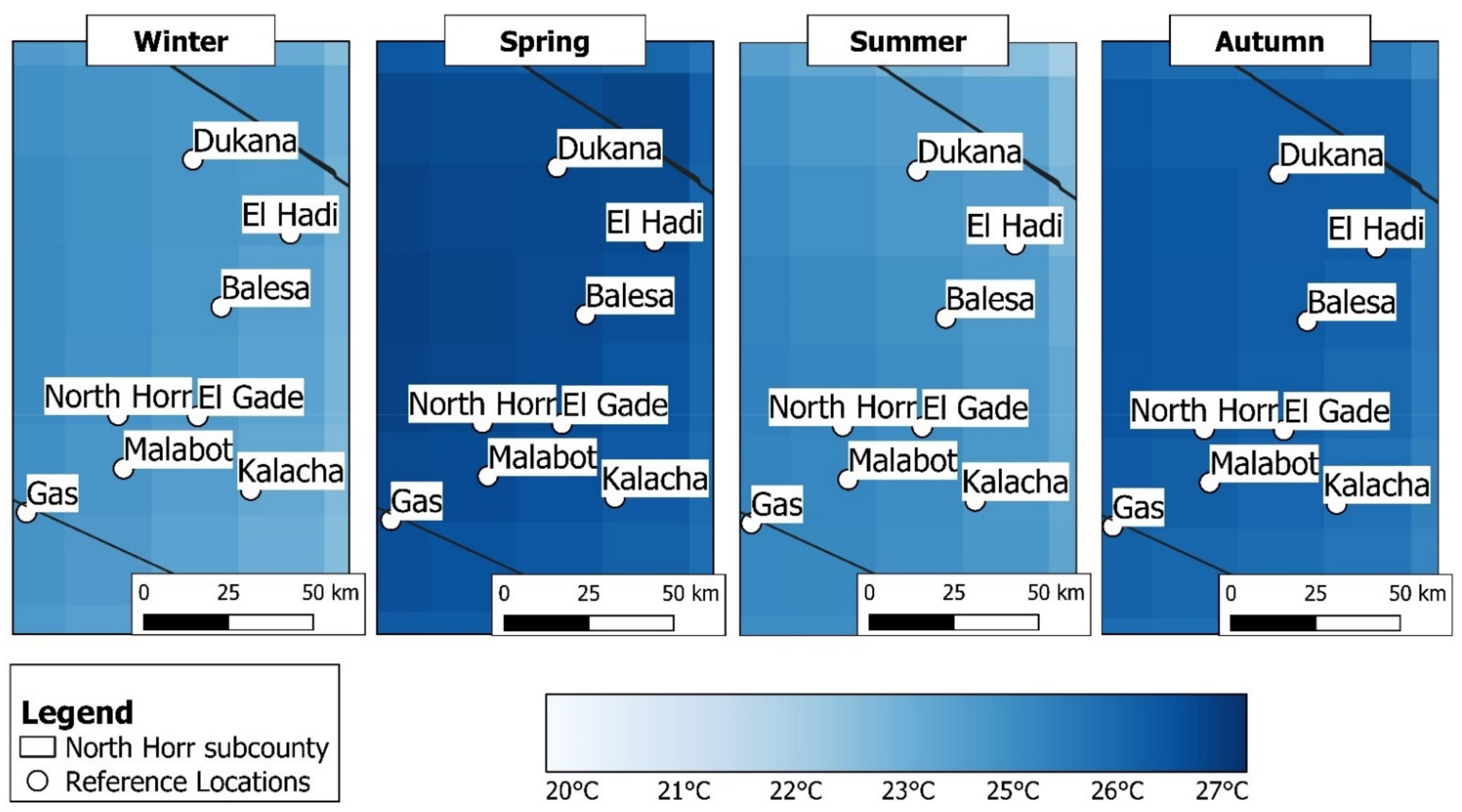
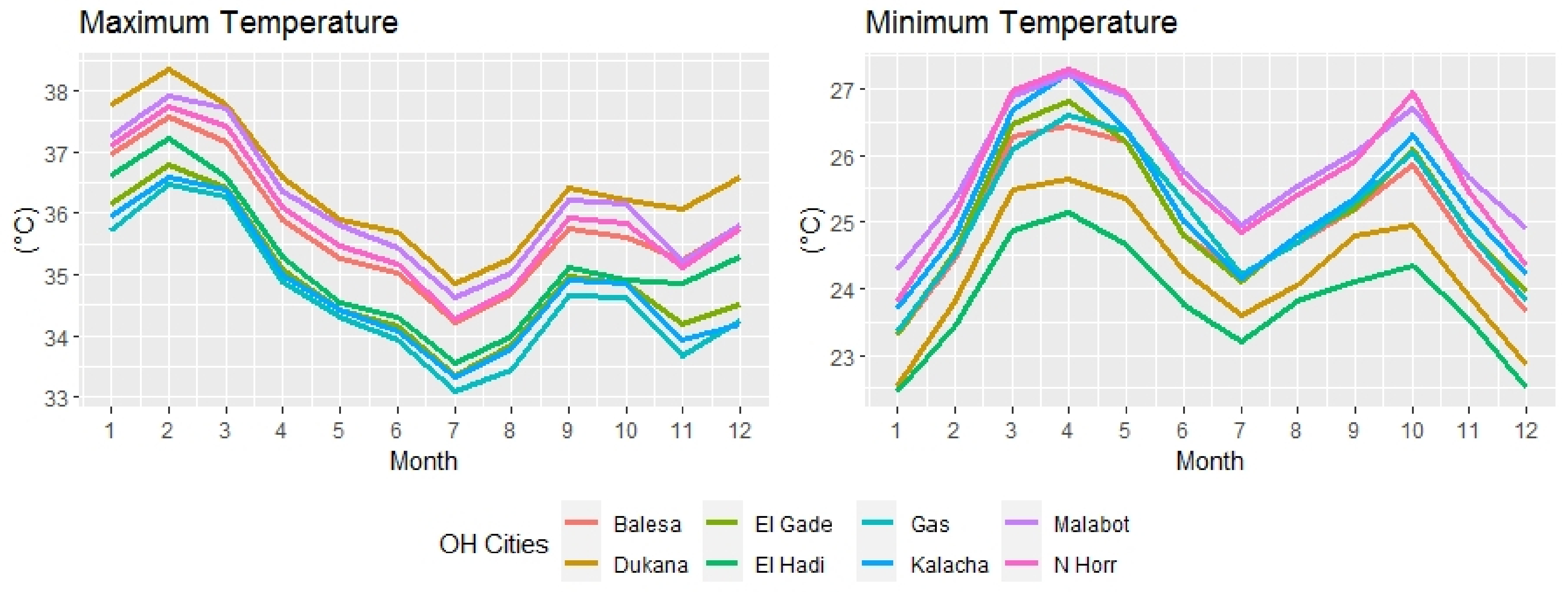
3.4. Calculation of Seasonal/Monthly Temperature Ranges for the Reference Points
3.5. Result Validation for North Horr
4. Conclusions
Author Contributions
Funding
Institutional Review Board Statement
Informed Consent Statement
Data Availability Statement
- KMD, available at: http://kmddl.meteo.go.ke:8081/SOURCES/.KMD/ (accessed on 16 November 2020);
- Era-Interim reanalysis, available at: https://www.ecmwf.int/en/forecasts/datasets/reanalysis-datasets/era-interim (accessed on 16 November 2020);
- Climate Limited Area Model (CCLM) driven by HadGEM2-ES (referred to as HAD), available at: https://climate4impact.eu/impactportal/data/esgfsearch.jsp (accessed on 16 November 2020);
- Observational Reanalysis Hybrid, available at: https://hydrology.princeton.edu/getdata.php?dataid=6 (accessed on 16 November 2020).
Acknowledgments
Conflicts of Interest
Appendix A

| Lodwar | Marsabit | Moyale | ||||
|---|---|---|---|---|---|---|
| Historical | ORH | Historical | ORH | Historical | ORH | |
| January | 36.1 | 36.8 | 25.3 | 30.3 | 31.0 | 31.3 |
| February | 37.2 | 37.7 | 26.7 | 31.2 | 31.9 | 31.9 |
| March | 36.9 | 37.4 | 26.6 | 31.2 | 30.6 | 31.4 |
| April | 36.0 | 36.4 | 25.3 | 29.8 | 27.4 | 28.5 |
| May | 35.3 | 35.5 | 24.9 | 29.1 | 25.8 | 26.6 |
| June | 34.5 | 34.9 | 24.0 | 28.7 | 24.9 | 25.9 |
| July | 33.7 | 33.9 | 23.5 | 28.0 | 24.0 | 25.3 |
| August | 34.2 | 34.4 | 24.1 | 28.4 | 24.9 | 26.0 |
| September | 35.4 | 35.9 | 25.3 | 29.7 | 26.8 | 27.5 |
| October | 35.9 | 35.5 | 25.4 | 29.8 | 26.8 | 27.4 |
| November | 35.2 | 35.0 | 24.0 | 28.3 | 27.1 | 27.8 |
| December | 35.5 | 36.0 | 23.9 | 29.2 | 29.1 | 29.3 |
| Autumn | 36.3 | 36.8 | 25.3 | 30.2 | 30.7 | 30.8 |
| Winter | 36.1 | 36.4 | 25.6 | 30.1 | 28.0 | 28.8 |
| Spring | 34.2 | 34.4 | 23.9 | 28.4 | 24.6 | 25.8 |
| Summer | 35.5 | 35.5 | 24.9 | 29.3 | 26.9 | 27.6 |
| Lodwar | Marsabit | Moyale | ||||
|---|---|---|---|---|---|---|
| Historical | ORH | Historical | ORH | Historical | ORH | |
| January | 22.2 | 22.8 | 16.5 | 17.9 | 18.6 | 18.0 |
| February | 22.7 | 23.7 | 16.8 | 18.6 | 19.6 | 18.9 |
| March | 24.2 | 24.5 | 17.1 | 19.4 | 19.9 | 19.4 |
| April | 24.8 | 24.6 | 17.1 | 19.6 | 19.2 | 18.9 |
| May | 25.1 | 24.5 | 16.7 | 19.0 | 18.5 | 18.3 |
| June | 24.8 | 24.1 | 15.2 | 17.9 | 17.2 | 17.6 |
| July | 24.3 | 23.7 | 14.2 | 17.2 | 16.6 | 16.8 |
| August | 24.5 | 23.9 | 14.1 | 17.3 | 16.8 | 16.9 |
| September | 25.0 | 24.1 | 14.6 | 17.9 | 17.5 | 17.4 |
| October | 25.3 | 24.5 | 15.9 | 18.9 | 18.2 | 17.8 |
| November | 23.9 | 23.6 | 16.5 | 18.6 | 18.0 | 17.5 |
| December | 22.3 | 23.0 | 16.5 | 18.2 | 18.0 | 17.7 |
| Autumn | 22.4 | 23.1 | 16.6 | 18.2 | 18.7 | 18.2 |
| Winter | 24.7 | 24.5 | 17.0 | 19.3 | 19.2 | 18.8 |
| Spring | 24.5 | 23.9 | 14.5 | 17.5 | 16.9 | 17.1 |
| Summer | 24.7 | 24.1 | 15.7 | 18.5 | 17.9 | 17.6 |
References
- Huq, S.; Reid, H.; Konate, M.; Rahman, A.; Sokona, Y.; Crick, F. Mainstreaming adaptation to climate change in Least Developed Countries (LDCs). Clim. Policy 2004, 4, 25–43. [Google Scholar] [CrossRef]
- Nordhaus, W.D. Geography and macroeconomics: New data and new findings. Proc. Natl. Acad. Sci. USA 2006, 103, 3510–3517. [Google Scholar] [CrossRef] [PubMed]
- Rose, R.M. The Impact of Climate Change on Human Security in the Sahel Region of Africa. Donnish J. Reg. Afr. 2015, 1, 9–14. [Google Scholar]
- Singh, A.; Purohit, B.M. Public Health Impacts of Global Warming and Climate Change. Peace Rev. 2014, 26, 112–120. [Google Scholar] [CrossRef]
- Niang, I.; Ruppel, O.C.; Abdrabo, M.A.; Essel, A.; Lennard, C.; Padgham, J.; Urquhart, P. Africa. Climate Change 2014: Impacts, Adaptation, and Vulnerability. Part B: Regional Aspects. Contribution of Working Group II to the Fifth Assessment Report of the Intergovernmental Panel on Climate Change. 2015, pp. 1199–1266. Available online: https://www.ipcc.ch/report/ar5/wg2/ (accessed on 16 November 2020).
- Rankings//Notre Dame Global Adaptation Initiative//University of Notre Dame. Available online:https://gain.nd.edu/our-work/country-index/rankings/ (accessed on 13 November 2020).
- UNDP. Climate Risks, Vulnerability and Governance in Kenya: A review. Undp 2012, 83, 22–26. [Google Scholar]
- Ministry of Foreign Affairs of the Netherlands. Climate Change PROFILE Kenya. Minist. Foreign Aff. Neth. 2018, 923, 14. [Google Scholar]
- (NCCAP—GoK) National Climate Change Action Plan 2013–2017; Government of Kenya: Nairobi, Kenya, 2013.
- Engels, B.; Dietz, K. Climate change in Africa: Social and political impacts, conflicts and strategies. Clim. Chang. Afr. Soc. Polit. Impacts Confl. Strateg. 2018, 1, 1–208. [Google Scholar]
- Tarhule, A.; Saley-Bana, Z.; Lamb, P.J. Rainwatch: A Prototype GIS for Rainfall Monitoring in West Africa. Bull. Am. Meteorol. Soc. 2009, 90, 1607–1614. [Google Scholar] [CrossRef]
- One Health Integrated Approach. North Horr|Comitato Collaborazione Medica. Available online:http://www.ccm-italia.org/en/one-health-north-horr (accessed on 16 November 2020).
- Kenya Meteorological Department. Available online: https://www.meteo.go.ke/ (accessed on 13 November 2020).
- County Consultations. Available online: https://www.kccap.info/index_option_com_phocadownload_view_category_id_37_Itemid_54.html (accessed on 13 November 2020).
- Tarhule, A.; Lamb, P.J. Climate research and seasonal forecasting for West Africans. Bull. Am. Meteorol. Soc. 2003, 84, 1741–1759. [Google Scholar] [CrossRef]
- UNDP. Factoring of Weather and Climate Information and Products into Disaster Management Policy: A contribution to Stategies for Disaster Reduction in Kenya; Kenya Meteorological Department: Nairobi, Kenya, 2002; pp. 1–206. [Google Scholar]
- Gan, T.Y.; Ito, M.; Hülsmann, S.; Qin, X.; Lu, X.X.; Liong, S.Y.; Rutschman, P.; Disse, M.; Koivusalo, H. Possible climate change/variability and human impacts, vulnerability of drought-prone regions, water resources and capacity building for Africa. Hydrol. Sci. J. 2016, 61, 1209–1226. [Google Scholar] [CrossRef]
- Anyah, R.O.; Semazzi, F.H.M. Climate variability over the Greater Horn of Africa based on NCAR AGCM ensemble. Theor. Appl. Climatol. 2006, 86, 39–62. [Google Scholar] [CrossRef]
- Anyah, R.O.; Semazzi, F.H.M. Variability of East African rainfall based on multiyear RegCM3 simulations. Int. J. Climatol. Int. J. Clim. 2007, 27, 357–371. [Google Scholar] [CrossRef]
- Diro, G.T.; Grimes, D.I.F.; Black, E. Teleconnections between Ethiopian summer rainfall and sea surface temperature: Part I-observation and modelling. Clim. Dyn. 2011, 37, 103–119. [Google Scholar] [CrossRef]
- Endris, H.S.; Omondi, P.; Jain, S.; Lennard, C.; Hewitson, B.; Chang’a, L.; Awange, J.L.; Dosio, A.; Ketiem, P.; Nikulin, G.; et al. Assessment of the performance of CORDEX regional climate models in simulating East African rainfall. J. Clim. 2013, 26, 8453–8475. [Google Scholar] [CrossRef]
- Vigna, I.; Bigi, V.; Pezzoli, A.; Besana, A. Comparison and bias-correction of satellite-derived precipitation datasets at local level in northern Kenya. Sustainability 2020, 12, 2896. [Google Scholar] [CrossRef]
- Bayissa, Y.; Tadesse, T.; Demisse, G.; Shiferaw, A. Evaluation of satellite-based rainfall estimates and application to monitor meteorological drought for the Upper Blue Nile Basin, Ethiopia. Remote Sens. 2017, 9, 669. [Google Scholar] [CrossRef]
- Dinku, T.; Thomson, M.C.; Cousin, R.; del Corral, J.; Ceccato, P.; Hansen, J.; Connor, S.J. Enhancing National Climate Services (ENACTS) for development in Africa. Clim. Dev. 2018, 10, 664–672. [Google Scholar] [CrossRef]
- Bitew, M.M.; Gebremichael, M.; Ghebremichael, L.T.; Bayissa, Y.A. Evaluation of high-resolution satellite rainfall products through streamflow simulation in a hydrological modeling of a small mountainous watershed in Ethiopia. J. Hydrometeorol. 2012, 13, 338–350. [Google Scholar] [CrossRef]
- Giorgi, F.; Gutowski, W.J. Regional Dynamical Downscaling and the CORDEX Initiative. Annu. Rev. Environ. Resour. 2015, 40, 467–490. [Google Scholar] [CrossRef]
- Gebrechorkos, S.H.; Hülsmann, S.; Bernhofer, C. Evaluation of multiple climate data sources for managing environmental resources in East Africa. Hydrol. Earth Syst. Sci. 2018, 22, 4547–4564. [Google Scholar] [CrossRef]
- Cattani, E.; Merino, A.; Levizzani, V. Evaluation of monthly satellite-derived precipitation products over East Africa. J. Hydrometeorol. 2016, 17, 2555–2573. [Google Scholar] [CrossRef]
- Marsabit County Government. Climate Change Mainstreaming Guidelines; Agriculture, Livestock and Fisheries Sector; Marsabit County Government: Marsabit, Kenya, 2018.
- Maina, M.M.; Messo, R.J. Analysis of the Trends in Temperature and Rainfall in Thika River Basin in Kenya. Int. J. Clim. Res. 2017, 2, 26–35. [Google Scholar] [CrossRef][Green Version]
- Karanja, F.K.; Mutua, F.M. Reducing the Impact of Environmental Emergencies through Early Warning and Preparedness—The Case of El Nino-Southern Oscillation. North 2000, 1, 1–55. [Google Scholar]
- Owiti, Z.; Ogallo, L.A.; Mutemi, J. Linkages between the Indian Ocean Dipole and east African seasonal rainfall anomalies. J. Kenya Meteorol. Soc. 2008, 2, 2–17. [Google Scholar]
- Berrisford, P.; Dee, D.; Fielding, K.; Fuentes, M.; Kallberg, P.; Kobayashi, S.; Uppala, S. The ERA-Interim Archive. ERA Rep. Ser. 2009, 1, 1–16. [Google Scholar]
- Dosio, A.; Panitz, H.J.; Schubert-Frisius, M.; Lüthi, D. Dynamical downscaling of CMIP5 global circulation models over CORDEX-Africa with COSMO-CLM: Evaluation over the present climate and analysis of the added value. Clim. Dyn. 2015, 44, 2637–2661. [Google Scholar] [CrossRef]
- Chaney, N.W.; Sheffield, J.; Villarini, G.; Wood, E.F. Development of a high-resolution gridded daily meteorological dataset over sub-Saharan Africa: Spatial analysis of trends in climate extremes. J. Clim. 2014, 27, 5815–5835. [Google Scholar] [CrossRef]
- Gebrechorkos, S.H.; Hülsmann, S.; Bernhofer, C. Statistically downscaled climate dataset for East Africa. Sci. Data 2019, 6, 2–9. [Google Scholar] [CrossRef]
- Wang, Y.; Leung, L.R.; McGregor, J.L.; Lee, D.K.; Wang, W.C.; Ding, Y.; Kimura, F. Regional climate modeling: Progress, challenges, and prospects. J. Meteorol. Soc. Jpn. 2004, 82, 1599–1628. [Google Scholar] [CrossRef]
- Wilks, D.L. Statistical Methods in the Atmospheric Sciences, 2nd ed.; Academic Press: Cambridge, MA, USA, 2006. [Google Scholar]
- Nairn, J.; Fawcett, R. Defining heatwaves: Heatwave defined as a heat-impact event servicing all community and business sectors in Australia. CAWCR Tech. Rep. 2013, 60, 1–79. [Google Scholar]


| Station | District | Latitude | Longitude | Altitude |
|---|---|---|---|---|
| Lodwar | Turkana | 3.1° | 35.6° | 523 m |
| Marsabit | Marsabit | 2.3° | 37.9° | 1345 m |
| Moyale | Lodwar | 3.53° | 39.1° | 1097 m |
| North Horr | North Horr | 3.3° | 37.1° | 361 m |
| Lodwar | Marsabit | Moyale | Overall Performances | |||||||||||||
|---|---|---|---|---|---|---|---|---|---|---|---|---|---|---|---|---|
| KMD | ERA | ORH | HAD | KMD | ERA | ORH | HAD | KMD | ERA | ORH | HAD | KMD | ERA | ORH | HAD | |
| TMAX | ||||||||||||||||
| Bias | −2.34 | −2.46 | 0.28 | −0.88 | 1.82 | 5.94 | 4.56 | 4.1 | 0.92 | 1.31 | 0.7 | 1.38 | 0.13 | 1.60 | 1.85 | 1.53 |
| MAE | 2.38 | 2.49 | 0.92 | 1.28 | 1.82 | 5.94 | 4.56 | 4.1 | 1.06 | 1.32 | 1.01 | 1.46 | 1.75 | 3.25 | 2.16 | 2.28 |
| MSE | 7.44 | 9.03 | 1.61 | 2.47 | 4.35 | 37.33 | 22.02 | 18.57 | 1.75 | 2.61 | 1.61 | 3.37 | 4.51 | 16.32 | 8.41 | 8.14 |
| RMSE | 2.73 | 3.01 | 1.27 | 1.57 | 2.09 | 6.11 | 4.69 | 4.31 | 1.32 | 1.62 | 1.27 | 1.84 | 2.05 | 3.58 | 2.41 | 2.57 |
| CC | 0.74 | 0.71 | 0.65 | 0.65 | 0.79 | 0.57 | 0.66 | 0.55 | 0.95 | 0.83 | 0.92 | 0.86 | 0.83 | 0.70 | 0.74 | 0.69 |
| TMIN | ||||||||||||||||
| Bias | 1.01 | −1.12 | −0.17 | 1.92 | 0.88 | 4.71 | 2.44 | 2.72 | 2.74 | 0.57 | −0.24 | −1 | 1.54 | 1.39 | 0.68 | 1.21 |
| MAE | 1.23 | 1.7 | 0.88 | 2.11 | 1.15 | 4.71 | 2.45 | 2.72 | 2.74 | 0.61 | 0.64 | 1.13 | 1.71 | 2.34 | 1.32 | 1.99 |
| MSE | 2.52 | 3.72 | 1.33 | 5.6 | 1.83 | 23.55 | 6.97 | 8.06 | 7.74 | 0.53 | 0.71 | 1.9 | 4.03 | 9.27 | 3.00 | 5.19 |
| RMSE | 1.59 | 1.93 | 1.15 | 2.37 | 1.35 | 4.85 | 2.64 | 2.84 | 2.78 | 0.73 | 0.84 | 1.38 | 1.91 | 2.50 | 1.54 | 2.20 |
| CC | 0.41 | 0.23 | 0.54 | 0.23 | 0.57 | 0.48 | 0.62 | 0.74 | 0.91 | 0.92 | 0.74 | 0.62 | 0.63 | 0.54 | 0.64 | 0.53 |
| Balesa | Dukana | El-Gade | El-Hadi | Gas | Kalacha | Malabot | North Horr | |
|---|---|---|---|---|---|---|---|---|
| Jan | 36–38 | 36.8–38.8 | 35.1–37.1 | 35.6–37.6 | 34.7–36.7 | 35–37 | 36.3–38.3 | 36.1–38.1 |
| Feb | 36.6–38.6 | 37.4–39.4 | 35.8–37.8 | 36.2–38.2 | 35.5–37.5 | 35.6–37.6 | 36.9–38.9 | 36.8–38.8 |
| Mar | 36.2–38.2 | 36.8–38.8 | 35.4–37.4 | 35.6–37.6 | 35.3–37.5 | 35.4–37.4 | 36.7–38.7 | 36.4–38.4 |
| Apr | 34.9–36.9 | 35.6–37.6 | 34.1–36.1 | 34.3–36.3 | 33.9–35.9 | 34–36 | 35.4–37.4 | 35.1–37.1 |
| May | 34.3–36.3 | 34.9–36.9 | 33.4–35.4 | 33.5–35.5 | 33.3–35.3 | 33.4–35.4 | 34.8–36.8 | 34.5–36.5 |
| June | 34–36 | 34.7–36.7 | 33.2–35.2 | 33.3–35.5 | 32.9–34.9 | 33.1–35.1 | 34.4–36.4 | 34.2–36.2 |
| July | 33.2–35.2 | 33.9–35.9 | 32.4–34.4 | 32.6–34.6 | 32.1–34.1 | 32.3–34.3 | 33.6–35.6 | 33.3–35.3 |
| Aug | 33.7–35.7 | 34.3–36.3 | 32.8–34.8 | 33–35 | 32.5–34.5 | 32.8–34.8 | 34–36 | 33.7–35.7 |
| Sep | 34.7–36.7 | 35.4–37.4 | 34–36 | 34.1–36.1 | 33.7–35.7 | 33.9–35.9 | 35.2–37.2 | 34.9–36.9 |
| Oct | 34.6–36.6 | 35.2–37.2 | 33.8–35.8 | 33.9–35.9 | 33.6–35.6 | 33.9–35.9 | 35.1–37.1 | 34.8–36.8 |
| Nov | 34.2–36.2 | 35.1–37.1 | 33.2–35.2 | 33.8–35.8 | 32.7–34.7 | 32.9–34.9 | 34.2–36.2 | 34.1–36.1 |
| Dec | 34.8–36.8 | 35.6–37.6 | 33.5–35.5 | 34.3–36.3 | 33.3–35.3 | 33.2–35.2 | 34.8–36.8 | 34.8–36.8 |
| Winter | 35.8–37.8 | 36.6–38.6 | 34.8–36.8 | 35.4–37.4 | 34.5–36.5 | 34.6–36.6 | 36–38 | 35.9–37.9 |
| Spring | 35.1–37.1 | 35.8–37.8 | 34.3–36.3 | 34.5–36.5 | 34.2–36.2 | 34.3–36.1 | 35.6–37.6 | 35.3–37.3 |
| Summer | 33.6–35.6 | 34.3–36.3 | 32.8–34.8 | 33–35 | 32.5–34.5 | 32.7–34.7 | 34–36 | 33.7–35.7 |
| Autumn | 34.5–36.5 | 35.2–37.2 | 33.7–35.7 | 33.9–35.9 | 33.3–35.3 | 33.6–35.6 | 34.8–36.8 | 34.6–36.6 |
| Balesa | Dukana | El-Gade | El-Hadi | Gas | Kalacha | Malabot | North Horr | |
|---|---|---|---|---|---|---|---|---|
| Jan | 22.3–24.3 | 21.6–23.6 | 22.3–24.3 | 21.5–23.5 | 22.4–24.4 | 22.7–24.7 | 23.3–25.2 | 22.8–24.8 |
| Feb | 23.5–25.5 | 22.8–24.8 | 23.6–25.6 | 22.5–24.5 | 23.5–25.5 | 23.8–25.8 | 24.4–26.4 | 24.1–26.1 |
| Mar | 25.3–27.3 | 24.5–26.5 | 25.5–27.5 | 23.9–25.9 | 25.1–27.1 | 25.7–27.7 | 25.9–27.9 | 26–28 |
| Apr | 25.5–27.5 | 24.7–26.7 | 25.8–27.8 | 24.2–26.2 | 25.6–27.6 | 26.3–28.3 | 26.2–28.2 | 26.3–28.3 |
| May | 25.2–27.2 | 24.4–26.4 | 25.2–27.2 | 23.7–25.7 | 25.4–27.4 | 25.4–27.4 | 25.9–27.9 | 26–28 |
| June | 23.8–25.8 | 23.3–25.3 | 23.8–25.8 | 22.8–24.8 | 24.3–26.3 | 24–26 | 24.8–26.8 | 24.6–26.6 |
| July | 23.2–25.2 | 22.6–24.6 | 23.1–25.1 | 22.2–24.2 | 23.2–25.2 | 23.2–25.2 | 24–25 | 23.9–25.9 |
| Aug | 23.7–25.7 | 23.1–25.1 | 23.8–25.8 | 22.8–24.8 | 23.7–25.7 | 23.8–25.8 | 24.6–26.6 | 24.6–26.6 |
| Sep | 24.2–26.2 | 23.8–25.8 | 24.2–26.2 | 23.1–25.1 | 24.3–26.3 | 24.4–26.4 | 25.1–27.1 | 24.9–26.9 |
| Oct | 24.9–26.9 | 24–26 | 25.1–27.1 | 23.4–25.4 | 25.1–27.1 | 25.3–27.3 | 25.7–27.7 | 26–28 |
| Nov | 23.7–25.7 | 22.9–24.9 | 23.8–25.8 | 22.5–24.5 | 23.8–25.8 | 24.2–26.2 | 24.7–26.7 | 24.5–26.5 |
| Dec | 22.7–24.7 | 21.9–23.9 | 23–25 | 21.5–23.5 | 22.8–24.8 | 23.2–25.2 | 23.9–25.9 | 23.4–25.4 |
| Winter | 22.8–24.8 | 22.1–24.1 | 23–25 | 21.8–23.8 | 22.9–24.9 | 23.2–25.2 | 23.9–25.9 | 23.4–25.4 |
| Spring | 25.3–27.3 | 24.5–26.5 | 25.5–27.5 | 23.9–25.9 | 25.4–27.4 | 25.8–27.8 | 26–28 | 26.1–28.1 |
| Summer | 23.6–25.6 | 23–25 | 23.6–25.6 | 22.6–24.6 | 23.7–25.7 | 23.7–25.7 | 24.5–26.5 | 24.3–26.3 |
| Autumn | 24.3–26.3 | 23.6–25.6 | 24.4–26.4 | 23–25 | 24.4–26.4 | 24.6–26.6 | 25.2–27.2 | 25.1–27.1 |
Publisher’s Note: MDPI stays neutral with regard to jurisdictional claims in published maps and institutional affiliations. |
© 2021 by the authors. Licensee MDPI, Basel, Switzerland. This article is an open access article distributed under the terms and conditions of the Creative Commons Attribution (CC BY) license (https://creativecommons.org/licenses/by/4.0/).
Share and Cite
Siciliano, G.; Bigi, V.; Vigna, I.; Comino, E.; Rosso, M.; Cristofori, E.; Demarchi, A.; Pezzoli, A. Comparison of Multiple Maximum and Minimum Temperature Datasets at Local Level: The Case Study of North Horr Sub-County, Kenya. Climate 2021, 9, 62. https://doi.org/10.3390/cli9040062
Siciliano G, Bigi V, Vigna I, Comino E, Rosso M, Cristofori E, Demarchi A, Pezzoli A. Comparison of Multiple Maximum and Minimum Temperature Datasets at Local Level: The Case Study of North Horr Sub-County, Kenya. Climate. 2021; 9(4):62. https://doi.org/10.3390/cli9040062
Chicago/Turabian StyleSiciliano, Giovanni, Velia Bigi, Ingrid Vigna, Elena Comino, Maurizio Rosso, Elena Cristofori, Alessandro Demarchi, and Alessandro Pezzoli. 2021. "Comparison of Multiple Maximum and Minimum Temperature Datasets at Local Level: The Case Study of North Horr Sub-County, Kenya" Climate 9, no. 4: 62. https://doi.org/10.3390/cli9040062
APA StyleSiciliano, G., Bigi, V., Vigna, I., Comino, E., Rosso, M., Cristofori, E., Demarchi, A., & Pezzoli, A. (2021). Comparison of Multiple Maximum and Minimum Temperature Datasets at Local Level: The Case Study of North Horr Sub-County, Kenya. Climate, 9(4), 62. https://doi.org/10.3390/cli9040062