Flood Vulnerability Analysis in Urban Context: A Socioeconomic Sub-Indicators Overview


Abstract
1. Introduction
2. The Definition of Vulnerability and Risk
3. Methods
3.1. Terms of Search and Literatura Database Used
3.2. Paper Selection Processes
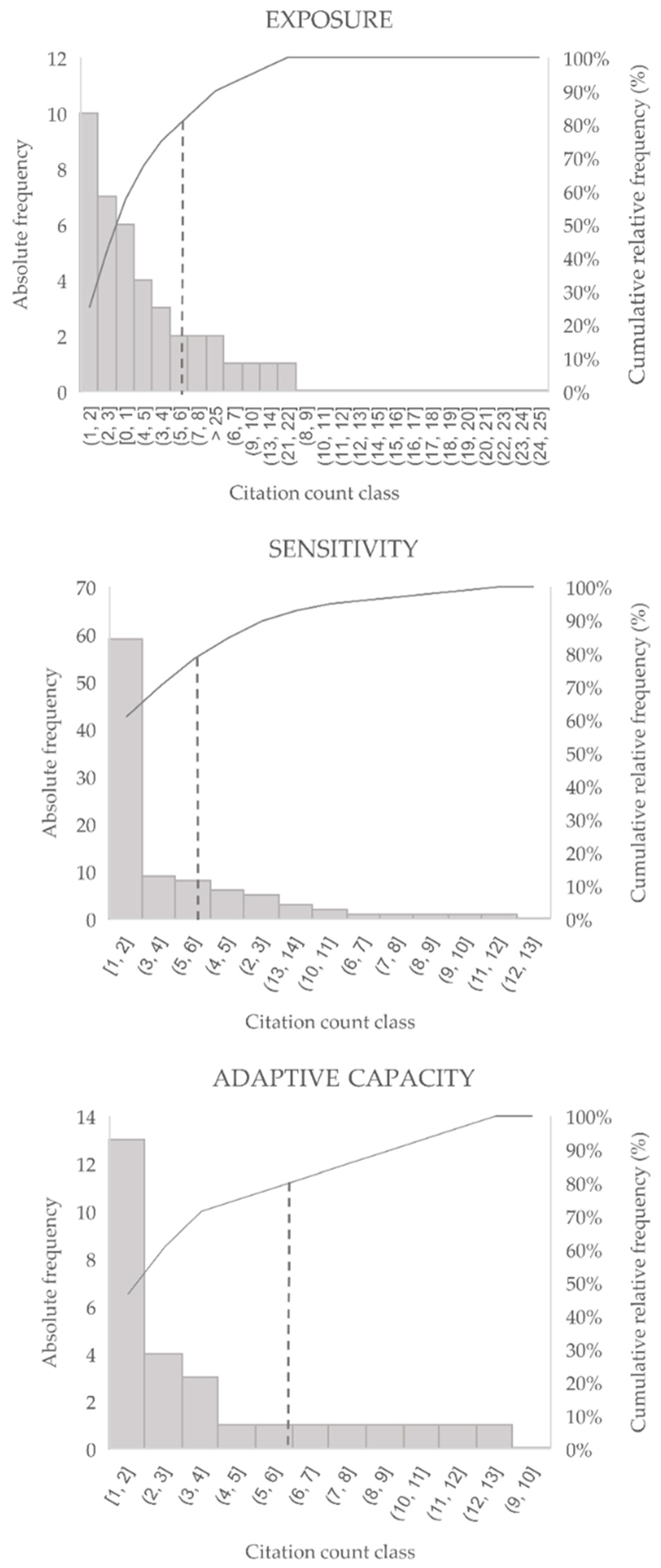
3.3. Threshold Identification for Sub-Indicators Retention
4. Results and Discussion
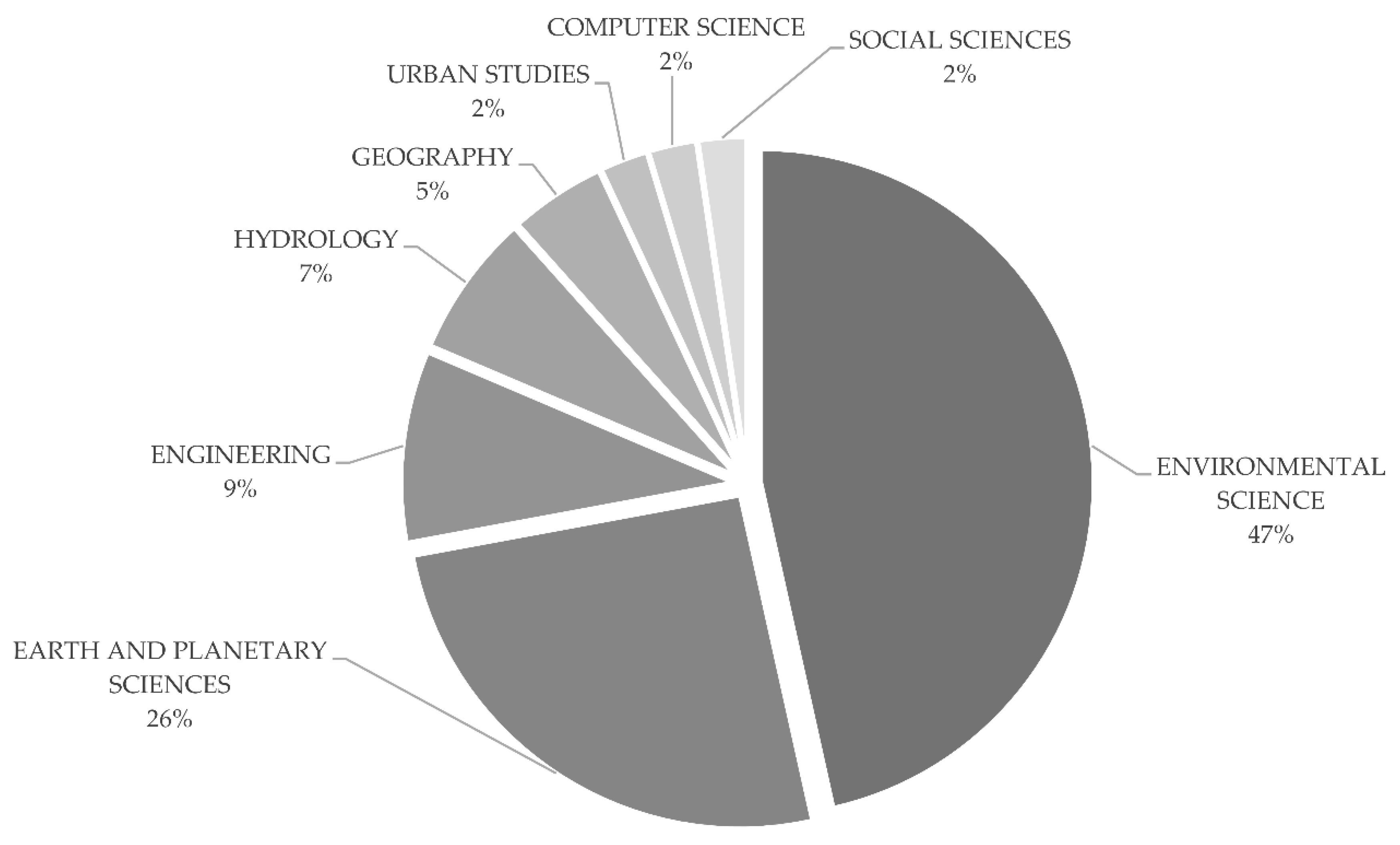
4.1. Study Selection
4.2. Brief Review: Risk Analysis Studies Selection Process
4.3. Content Analysis
4.4. Discussion on the Sub-Indicators Selected
5. Conclusions
Author Contributions
Funding
Conflicts of Interest
Appendix A

| EXPOSURE | ||
| GROUP | SUB-INDICATORS | REFERENCES |
| Topography/geography | Imperviousness/vertical permeability | [67,89,90] |
| Urbanized area, built-up area | [27,35,47,91,92,93,94] | |
| Rural area | [91,92] | |
| Degraded area | [27,92] | |
| Topography (elevation) | [35,52,53,60,67,92,94,95] | |
| Vegetation cover | [65,67,90] | |
| Green spaces/urban green coverage | [14,35,59,76,90,96,97] | |
| Slope | [27,52,59,66] | |
| Forested area | [27,57,91] | |
| Land use | [14,27,53,65,95] | |
| River/flood | Distance from the river | [52] |
| River network | [52,53] | |
| Flooded area/submerged area/inundation area | [50,67,96,97,98] | |
| Water depth/inundation depth | [27,50,66] | |
| Flood duration | [27,50,66,98] | |
| Runoff | [57,96] | |
| Sedimentation load | [27] | |
| River discharge | [27,57,66] | |
| Return period | [14,27,59,63,66] | |
| Rainfall | Comprehensive rainfall value | [39] |
| Flood seasonal rainfall | [45,52,94] | |
| Continuous rainfall day | [35,53] | |
| Monthly average precipitation/monthly total precipitation | [35,53] | |
| Maximum rainfall in 24 h | [35,53,94] | |
| Annual maximum precipitation | [95] | |
| Average annual rainfall | [52,57,59,72,96] | |
| Heavy rainfall | [27,35] | |
| Other physical factors | Evaporation | [27,57] |
| Population | Total Population | [64,71] |
| Population in flooded area | [27,35,45,66] | |
| Unpopulated area | [27] | |
| Population density | [27,28,38,39,43,47,52,55,57,60,61,62,63,65,67,69,71,90,91,92,93,95,97,99,100,101] | |
| Rural population | [27,28] | |
| Household composition | Inhabitants aged 0–4/5 | [61,64,65,67,68,71,90,91,95,98] |
| Inhabitants aged 5–13 | [14,38,39,60,61,63,68,69,71,72,90,91,93,95,99,100,102,103] | |
| Inhabitants aged 15–64 | [14,28,63,71,72,90,91] | |
| Inhabitants aged 65 or older | [14,28,38,39,60,61,63,64,65,66,67,68,69,71,72,89,90,91,93,95,98,99,100,102,103,104] | |
| Household where people aged 65 or older live | [61,63,71,100,105] | |
| Household size | [50,58,63,66,90,91,97,98,99,100] | |
| SENSITIVITY | ||
| GROUP | SUB-INDICATORS | REFERENCES |
| Social point of interest | Kindergartens | [61,64,69,71,106] |
| Elementary schools | [61,64,69,71,106] | |
| Secondary schools | [64,69,71,106] | |
| Retirement homes | [71,106] | |
| Health centers, hospitals | [27,57,64,69,71] | |
| Church | [64] | |
| Facilities | Electrical transformers in flood prone area | [39,89,106] |
| Bridges and overpasses located in flood prone area | [39] | |
| Length of street at flood prone area | [106] | |
| Parks and gardens at flood prone area | [106] | |
| Roads | [39] | |
| Water network | [69,89] | |
| Residential/commercial building | Productivity land | [65] |
| % Buildings with no residential function | [89,91] | |
| Number of dwellings located at flood prone area | [58,64,66,89,91,92,99,106] | |
| Main houses | [89,91,106] | |
| Damages to building (use, type) | [39,43] | |
| Secondary houses | [89,105] | |
| Social characteristics | Dependency rate | [50,71,97,98,100,104] |
| Population projections/growth | [27,57,71,90] | |
| Population changes over time (past) | [62] | |
| Illiterate people | [61,69,71,98,99,100] | |
| Population with low education level (<9 years) | [28,59,61,64,91,104] | |
| Population with high education level (>university degree) | [61,91] | |
| Education level | [27,38,43,50,58,60,66,67,97,98,99,100] | |
| Child mortality | [27,57] | |
| Foreigners | [59,61,63,69,71,100] | |
| Minorities | [93,102,103] | |
| Institutionalized groups (e.g., correctional institutions, nursing homes) | [50] | |
| % People with disabilities | [27,38,50,57,60,65,69,71,89,95,97,98,100,104] | |
| % Population living under poverty level | [27,60,65,100] | |
| Household economic characteristics | Unemployment rate | [14,27,28,50,57,60,63,67,76,90,93,98,100,106] |
| People without permanent income | [76,97] | |
| Long-term unemployed people | [71] | |
| Household where unemployed people live | [71] | |
| Benefit claimants | [70,71,72,73,74,75,76,77,78,79,80,81,82,83,84,85,86,87,88,89,90,91,92,93,94,95,96,97,98] | |
| Low-income households | [62,68,104] | |
| Dependency on public infrastructure | [14,58,68,90,93,97] | |
| HH responsible that earn at least twice the min salary | [64] | |
| Income gap between urban and rural residents | [105] | |
| Building characteristics | Permanent households | [71] |
| Vacant households | [71] | |
| Type of utilization | [38,43,50,52,95,100] | |
| Percentage of homes rented/owned | [50,60,61,90,91,97] | |
| One- or two-family homes | [28] | |
| Age of construction | [43,50,52,59,61,71,91,97,99,103] | |
| Underground built-up area/entries | [71,95] | |
| Building condition (quality/type of the materials) | [14,38,39,43,50,60,66,71,76,90,92,96,97,100] | |
| Households with 1 story above ground level and/or 1 story below ground level | [14,43,50,71,76,90,91,95,97,103,106] | |
| Households with 2 or more stories above ground level | [14,71,90,91,97,99,100,103,106] | |
| Economic value | [65] | |
| Living space (HH space per capita) | [28,71,76,99] | |
| Travel time | Distance to train station | [62] |
| Distance to the nearest hospital | [71,92] | |
| Travel time to the nearest hospital | [58,71] | |
| Distance to the nearest health center | [71] | |
| Travel time to the nearest health center | [50,71,97,98] | |
| Society characteristics | Number of workers in agricultural sector | [106] |
| Number of workers in industry, construction and service sector | [61,62,71,89] | |
| Self employed | [62] | |
| Income classes subdivision | [14,68,90,98,102] | |
| % Female | [38,50,61,62,65,67,91,97,98,100,104] | |
| Social level | [89] | |
| Crime rate | [100] | |
| Relationship between the neighbors | [58,90,97,98] | |
| Industries or other economic activities | [57,59,66,96,98,105] | |
| Economic indexes | Municipal debt per inhabitants | [71,106] |
| Municipal available budget per inhabitant | [71,106] | |
| Tax base of the property tax | [59,106] | |
| Per capita income | [50,61,71,93,97,100,106] | |
| GDP per capita/GDP per HH/GDP per neighborhood | [27,35,52,53] | |
| Ratio between taxable income and taxpayers in each municipality | [39] | |
| Fixed investment per inhabitants | [71,106] | |
| Ratio of investment over the total GDP/revenue–expenditure ratio | [47,57] | |
| Replacement cost for dwellings located at flood prone area | [106] | |
| Transportation | Vehicle available | [39,69,89,97,106] |
| Mean age of the vehicle fleet | [106] | |
| Traffic volume | [95] | |
| Mean duration of commute | [99] | |
| Development | Per capita/city’s fixed asset investment | [47,94] |
| Per capita water resources | [45] | |
| Urbanization rate | [39,45,52] | |
| Human Development Index | [27,57] | |
| Inequality | [27,100] | |
| Life expectancy index | [27,100] | |
| Urban growth | [27,57] | |
| Infrastructure development level | [105] | |
| Natural reservation | [27] | |
| Urban water area % | [35,94] | |
| Other | Primary industrial output value | [94] |
| Per capita secondary and tertiary industrial output value | [94] | |
| Arable lands | [45,52] | |
| Protected objects of historical interest | [27,39,66,71] | |
| Unplanned settlements | [38,60] | |
| Unplanned waste deposits | [67,68] | |
| Damages from previous flood/direct economic loss from previous flood | [45,50,90,98] | |
| Tourist accommodation capacity | [71,106] | |
| ADAPTIVE CAPACITY | ||
| GROUP | SUB-INDICATORS | REFERENCES |
| Economic indexes | Investment for damage reparation | [89] |
| Public disaster response capacity | [35,45] | |
| Economic recovery/disaster relief investment/post disaster reconstruction capability | [27,35,94] | |
| Municipal flood control investments | [45] | |
| Risk insurance | [27,50,53,57,66,67,89,90] | |
| Warning system | [27,57,60,64,66,70,89,97,100] | |
| Warning system | Past experience | [27,50,57,58,64,66,69,90,98,105] |
| Preparedness/awareness | [27,38,39,43,50,57,60,64,66,89,90,97,100] | |
| Communication devices | [50] | |
| Communication penetration rate | [27,100] | |
| Temporary displacement to another place | [58] | |
| Emergency response | Government assistance | [58] |
| Road density | [43,45,52,89,92,98,99] | |
| Evacuation routes | [27,57,60,66,69,97] | |
| Number of people working in the emergency services | [27,57,66,69,95] | |
| Reserve and distribution capacity of flood control materials | [45] | |
| Emergency rescue capacity of public administration | [45] | |
| Hospital beds | [47,71,100] | |
| Medical staff | [47,69,71,105] | |
| Reception centers | [69] | |
| Investment in coping capacity | [27,64] | |
| Preventive measures | Land use regulation | [60,89] |
| Flood control standards/plans | [39,43,94] | |
| Hydraulic infrastructures | [39] | |
| Protective infrastructures | Dikes/levees | [27,57,66,100] |
| Drainage network/pipelines density | [35,43,45,47,52,53,57,68,70,92,94,96] | |
| Dams storage capacity/reservoir capacity | [27,52,57] | |
| Protection of rivers at flood prone area | [14,66,100,106] | |
References
- Zio, E.; Pedroni, N. Overview of Risk-Informed Decision-Making Processes; Fondation pour une Culture de Sécurité Industrielle; Cahiers de la Sécurité Industrielle: Toulouse, France, 2012. [Google Scholar]
- United Nations Office for Disaster Risk Reduction. Sendai Framework for Disaster Risk Reduction 2015–2030; United Nations Office for Disaster Risk Reduction: Geneva, Switzerland, 2015. [Google Scholar]
- IPCC. Climate Change 2014 Impacts, Adaptation, and Vulnerability Part A: Global and Sectoral Aspects Working Group II Contribution to the Fifth Assessment Report of the Intergovernmental Panel on Climate Change; Field, C.B., Barros, V.R., Dokken, D.J., Mach, K.J., Mastrandrea, M.D., Bilir, T.E., Chatterjee, M., Yuka, K.L.E., Estrada, O., Genova, R.C., et al., Eds.; Cambridge University Press: Cambridge, UK; New York, NY, USA, 2014; ISBN 978-1-107-05807-1. [Google Scholar]
- Quevauviller, P. Adapting to climate change: Reducing water-related risks in Europe—EU policy and research considerations. Environ. Sci. Policy 2011, 14, 722–729. [Google Scholar] [CrossRef]
- Rufat, S.; Tate, E.; Burton, C.G.; Maroof, A.S. Social vulnerability to floods: Review of case studies and implications for measurement. Int. J. Disaster Risk Reduct. 2015, 14, 470–486. [Google Scholar] [CrossRef]
- European Parliament; Council of the European Union. Directive 2007/60/EC of the European Parliament and of the Council of 23 October 2007 on the Assessmentand Management of Flood Risks; European Parliament: Luxembourg, 2007.
- Plate, E.J. Flood risk and flood management. J. Hydrol. 2002, 267, 2–11. [Google Scholar] [CrossRef]
- Merz, B.; Hall, J.; Disse, M.; Schumann, A. Fluvial flood risk management in a changing world. Nat. Hazards Earth Syst. Sci. 2010, 10, 509–527. [Google Scholar] [CrossRef]
- Blaikie, P.M.; Cannon, T.; Wisner, B.; Davis, I. At Risk: Natural Hazards, People’s Vulnerability and Disasters, 2nd ed.; Routledge: London, UK, 2004; ISBN 0415252156. [Google Scholar]
- Kelly, P.M.; Adger, W.N. Theory and practice in assessing vulnerability to climate change and facilitating adaptation. Clim. Chang. 2000, 47, 325–352. [Google Scholar] [CrossRef]
- Birkmann, J. Measuring vulnerability to natural hazards: Conceptual framework and definitions. In Measuring Vulnerability to Natural Hazards: Towards Disaster Resilient Societies; Birkmann, J., Ed.; United Nations University Press: New York, NY, USA, 2006; pp. 9–54. ISBN 8179931226. [Google Scholar]
- Cutter, S.L.; Mitchell, J.T.; Scott, M.S. Revealing the vulnerability of people and places: A Case study of Georgetown county, South Carolina. Ann. Assoc. Am. Geogr. 2000, 90, 713–737. [Google Scholar] [CrossRef]
- Adger, W.N.; Kelly, P.M. Social vulnerability to climate change and the architecture of entitlements. Mitig. Adapt. Strateg. Glob. Chang. 1999, 4, 253–266. [Google Scholar] [CrossRef]
- Krellenberg, K.; Welz, J. Assessing urban vulnerability in the context of flood and heat hazard: Pathways and challenges for indicator-based analysis. Soc. Indic. Res. 2017, 132, 709–731. [Google Scholar] [CrossRef]
- Hajar, N.; Yusof, M.J.M.; Ahmad Mohammad Ali, T. An overview to flood vulnerability assessment methods. Sustain. Water Resour. Manag. 2016, 2, 331–336. [Google Scholar] [CrossRef]
- Carreño, M.L.; Cardona, O.D.; Barbat, A.H. A disaster risk management performance index. Nat. Hazards 2007, 41, 1–20. [Google Scholar] [CrossRef]
- Cardona, O.-D.; van Aalst, M.K.; Birkmann, J.; Fordham, M.; McGregor, G.; Perez, R.; Pulwarty, R.S.; Lisa Schipper, E.F.; Tan Sinh, B.; Décamps, H.; et al. Determinants of risk: Exposure and vulnerability. In Managing the Risks of Extreme Events and Disasters to Advance Climate Change Adaptation; Field, C.B.V., Barros, T.F., Stocker, D., Qin, D.J., Dokken, K.L., Ebi, M.D., Mastrandrea, K.J., Mach, G.-K., Plattner, S., Eds.; A Special Report of Working Groups I and II of the Intergovernmental Panel on Climate Change (IPCC); Cambridge University Press: Cambridge, UK; New York, NY, USA, 2012; pp. 65–108. [Google Scholar]
- Rehman, S.; Sahana, M.; Hong, H.; Sajjad, H.; Ahmed, B. Bin A systematic review on approaches and methods used for flood vulnerability assessment: Framework for future research. Nat. Hazards 2019, 96, 975–998. [Google Scholar] [CrossRef]
- Salas, J.; Yepes, V.V. Urban vulnerability assessment: Advances from the strategic planning outlook. J. Clean. Prod. 2018, 179, 544–558. [Google Scholar] [CrossRef]
- Gouldby, B.; Samuels, P.G. Language of Risk—Project Definitions, 2nd ed.; FLOODsite: Wallingford, UK, 2009. [Google Scholar]
- Klijn, F.; Kreibich, H.; de Moel, H.; Penning-Rowsell, E. Adaptive flood risk management planning based on a comprehensive flood risk conceptualisation. Mitig. Adapt. Strateg. Glob. Chang. 2015, 20, 845–864. [Google Scholar] [CrossRef]
- Merz, B.; Thieken, A.H.; Gocht, M. Flood risk mapping at the local scale: Concepts and challenges. In Advances in Natural and Technological Hazards Research; Springer: Dortrech, The Netherlands, 2007; Volume 25, pp. 231–251. [Google Scholar]
- Borbor-Cordova, M.J.; Ger, G.; Valdiviezo-Ajila, A.A.; Arias-Hidalgo, M.; Matamoros, D.; Nolivos, I.; Menoscal-Aldas, G.; Valle, F.; Pezzoli, A.; Cornejo-Rodriguez, M.D.P. An operational framework for urban vulnerability to floods in the Guayas estuary region: The Duran case study. Sustainability 2020, 12, 10292. [Google Scholar] [CrossRef]
- Klijn, F.; Samuels, P.; Van Os, A. Towards flood risk management in the EU: State of affairs with examples from various European countries. Int. J. River Basin Manag. 2008, 6, 307–321. [Google Scholar] [CrossRef]
- Samuels, P.; Wallingford, H.R. Language of Risk. Project Definitions; FLOODsite: Wallingford, UK, 2005. [Google Scholar]
- Tchórzewska-Cieślak, B.; Pietrucha-Urbanik, K.; Zygmunt, A.; Eng, M. Implementation of matrix methods in flood risk analysis and assessment. Ekon. I Sr. 2018, 3, 8–24. [Google Scholar]
- Balica, S.F.; Douben, N.; Wright, N.G. Flood vulnerability indices at varying spatial scales. Water Sci. Technol. 2009, 60, 2571–2580. [Google Scholar] [CrossRef]
- Fekete, A. Validation of a social vulnerability index in context to river-floods in Germany. Nat. Hazards Earth Syst. Sci. 2009, 9, 393–403. [Google Scholar] [CrossRef]
- United Nations General Assembly. International Decade for Natural Disaster Reduction: Resolution/Adopted by the General Assembly; Resolution 44/236—85th Plenary Meeting Session from 22 December 1989; United Nations General Assembly: New York, NY, USA, 1989. [Google Scholar]
- Cutter, S.L.; Boruff, B.J.; Shirley, W.L. Social vulnerability to environmental hazards. Soc. Sci. Q. 2003, 84, 242–261. [Google Scholar] [CrossRef]
- Juran, J.M.; Godfrey, B.A. Juran’s Quality Handbook, 5th ed.; McGraw-Hill: New York, NY, USA, 1998; ISBN 007034003X. [Google Scholar]
- Armenakis, C.; Du, E.X.; Natesan, S.; Persad, R.A.; Zhang, Y. Flood risk assessment in urban areas based on spatial analytics and social factors. Geosciences 2017, 7, 123. [Google Scholar] [CrossRef]
- Cai, T.; Li, X.; Ding, X.; Wang, J.; Zhan, J. Flood risk assessment based on hydrodynamic model and fuzzy comprehensive evaluation with GIS technique. Int. J. Disaster Risk Reduct. 2019, 35, 101077. [Google Scholar] [CrossRef]
- Huang, X.; Li, W.; Chen, Y.; Fang, G.; Yan, W. Risk assessment of floodwater resources utilization in water transfer projects based on an improved cloud model. Water Sci. Technol. Water Supply 2019, 19, 2517–2532. [Google Scholar] [CrossRef]
- Chen, J.; Chen, M.; Zhou, P. Using Multiple index comprehensive method to assess urban rainstorm disaster risk in Jiangsu province, China. Math. Probl. Eng. 2020, 2020, 1–10. [Google Scholar] [CrossRef]
- Domeneghetti, A.; Carisi, F.; Castellarin, A.; Brath, A. Evolution of flood risk over large areas: Quantitative assessment for the Po river. J. Hydrol. 2015, 527, 809–823. [Google Scholar] [CrossRef]
- Edjossan-Sossou, A.M.; Deck, O.; Al Heib, M.; Verdel, T. A decision-support methodology for assessing the sustainability of natural risk management strategies in urban areas. Nat. Hazards Earth Syst. Sci. 2014, 14, 3207–3230. [Google Scholar] [CrossRef]
- Elboshy, B.; Kanae, S.; Gamaleldin, M.; Ayad, H.; Osaragi, T.; Elbarki, W. A framework for pluvial flood risk assessment in Alexandria considering the coping capacity. Environ. Syst. Decis. 2019, 39, 77–94. [Google Scholar] [CrossRef]
- Ellena, M.; Ricciardi, G.; Barbato, G.; Buffa, A.; Villani, V.; Mercogliano, P. Past and future hydrogeological risk assessment under climate change conditions over urban settlements and infrastructure systems: The case of a sub-regional area of Piedmont, Italy. Nat. Hazards 2020, 102, 275–305. [Google Scholar] [CrossRef]
- Geng, Y.; Zheng, X.; Wang, Z.; Wang, Z. Flood risk assessment in Quzhou City (China) using a coupled hydrodynamic model and fuzzy comprehensive evaluation (FCE). Nat. Hazards 2020, 100, 133–149. [Google Scholar] [CrossRef]
- Hossain, M.K.; Meng, Q. A thematic mapping method to assess and analyze potential urban hazards and risks caused by flooding. Comput. Environ. Urban Syst. 2020, 79. [Google Scholar] [CrossRef]
- Kaźmierczak, A.; Cavan, G. Surface water flooding risk to urban communities: Analysis of vulnerability, hazard and exposure. Landsc. Urban Plan. 2011, 103, 185–197. [Google Scholar] [CrossRef]
- Koc, K.; Işık, Z. A multi-agent-based model for sustainable governance of urban flood risk mitigation measures. Nat. Hazards 2020, 104, 1079–1110. [Google Scholar] [CrossRef]
- Kubal, C.; Haase, D.; Meyer, V.; Scheuer, S. Natural hazards and earth system sciences integrated urban flood risk assessment—Adapting a multicriteria approach to a city. Nat. Hazards Earth Syst. Sci. 2009, 9, 1881–1895. [Google Scholar] [CrossRef]
- Chen, J.; Li, Q.; Wang, H.; Deng, M. A machine learning ensemble approach based on random forest and radial basis function neural network for risk evaluation of regional flood disaster: A case study of the yangtze river delta, China. Int. J. Environ. Res. Public Health 2020, 17, 49. [Google Scholar] [CrossRef]
- Lin, K.; Chen, H.; Xu, C.-Y.; Yan, P.; Lan, T.; Liu, Z.; Dong, C. Assessment of flash flood risk based on improved analytic hierarchy process method and integrated maximum likelihood clustering algorithm. J. Hydrol. 2020, 584, 124696. [Google Scholar] [CrossRef]
- Lv, H.; Guan, X.; Meng, Y. Comprehensive evaluation of urban flood-bearing risks based on combined compound fuzzy matter-element and entropy weight model. Nat. Hazards 2020, 103, 1823–1841. [Google Scholar] [CrossRef]
- Maantay, J.; Maroko, A.; Culp, G. Using geographic information science to estimate vulnerable urban populations for flood hazard and risk assessment in New York city. In Geospatial Techniques in Urban Hazard and Disaster Analysis; Showalter, P.S., Lu, Y., Eds.; Springer: Dordrecht, The Netherlands, 2010; Volume 2, pp. 71–97. ISBN 978-90-481-2237-0. [Google Scholar]
- Müller, A. Flood risks in a dynamic urban agglomeration: A conceptual and methodological assessment framework. Nat. Hazards 2013, 65, 1931–1950. [Google Scholar] [CrossRef]
- Rana, I.A.; Routray, J.K. Integrated methodology for flood risk assessment and application in urban communities of Pakistan. Nat. Hazards 2018, 91, 239–266. [Google Scholar] [CrossRef]
- Ronco, P.; Bullo, M.; Torresan, S.; Critto, A.; Olschewski, R.; Zappa, M.; Marcomini, A. KULTURisk regional risk assessment methodology for water-related natural hazards—Part 2: Application to the Zurich case study. Hydrol. Earth Syst. Sci. 2015, 19, 1561–1576. [Google Scholar] [CrossRef]
- Shi, Y.; Zhai, G.; Zhou, S.; Lu, Y.; Chen, W.; Deng, J. How can cities respond to flood disaster risks under multi-scenario simulation? A case study of Xiamen, China. Int. J. Environ. Res. Public Health 2019, 16, 618. [Google Scholar] [CrossRef]
- Sun, D.C.; Huang, J.; Wang, H.M.; Wang, Z.Q.; Wang, W.Q. Risk assessment of urban flood disaster in Jingdezhen City based on analytic hierarchy process and geographic information system. In Proceedings of the IOP Conference Series: Earth and Environmental Science Science and 3rd International Conference on Water Resource and Environment (WRE 2017), Qingdao, China, 26–29 June 2017; Institute of Physics Publishing: Briston, UK, 2017; Volume 82. [Google Scholar]
- Wang, G.; Liu, Y.; Hu, Z.; Lyu, Y.; Zhang, G.; Liu, J.; Liu, Y.; Gu, Y.; Huang, X.; Zheng, H.; et al. Flood risk assessment based on fuzzy synthetic evaluation method in the Beijing-Tianjin-Hebei metropolitan area, China. Sustainability 2020, 12, 1451. [Google Scholar] [CrossRef]
- Yoon, S.K.; Kim, J.S.; Moon, Y. Il Integrated flood risk analysis in a changing climate: A case study from the Korean Han River Basin. KSCE J. Civ. Eng. 2014, 18, 1563–1571. [Google Scholar] [CrossRef]
- Yu, C.; Liu, M.; Xu, X.; Shi, Y. The urban rain-flood risk division based on the cloud model and the entropy evaluation method—Taking Changzhou as an example. J. Phys. 2019, 1168, 032087. [Google Scholar] [CrossRef]
- Balica, S.; Wright, N.G. Reducing the complexity of the flood vulnerability index. Environ. Hazards 2010, 9, 321–339. [Google Scholar] [CrossRef]
- Sarmah, T.; Das, S.; Narendr, A.; Aithal, B.H. Assessing human vulnerability to urban flood hazard using the analytic hierarchy process and geographic information system. Int. J. Disaster Risk Reduct. 2020, 50, 101659. [Google Scholar] [CrossRef]
- Jeong, S.; Yoon, D.K. Examining vulnerability factors to natural disasters with a spatial autoregressive model: The case of South Korea. Sustainability 2018, 10, 1651. [Google Scholar] [CrossRef]
- Rasch, R.J. Assessing urban vulnerability to flood hazard in Brazilian municipalities. Environ. Urban. 2016, 28, 145–168. [Google Scholar] [CrossRef]
- Gu, H.; Du, S.; Liao, B.; Wen, J.; Wang, C.; Chen, R.; Chen, B. A hierarchical pattern of urban social vulnerability in Shanghai, China and its implications for risk management. Sustain. Cities Soc. 2018, 41, 170–179. [Google Scholar] [CrossRef]
- Kirby, R.H.; Reams, M.A.; Lam, N.S.N.N.; Zou, L.; Dekker, G.G.J.J.; Fundter, D.Q.P.P. Assessing social vulnerability to flood hazards in the Dutch province of Zeeland. Int. J. Disaster Risk Sci. 2019, 10, 233–243. [Google Scholar] [CrossRef]
- Welle, T.; Depietri, Y.; Angignard, M.; Birkmann, J.; Renaud, F.; Greiving, S. Vulnerability assessment to heat waves, floods, and earthquakes using the MOVE framework: Test case cologne, Germany. Assess. Vulnerability Nat. Hazards A 2014, 91–124. [Google Scholar] [CrossRef]
- Andrade, M.M.N.d.; Szlafsztein, C.F. Vulnerability assessment including tangible and intangible components in the index composition: An Amazon case study of flooding and flash flooding. Sci. Total Environ. 2018, 630, 903–912. [Google Scholar] [CrossRef]
- Djamaluddin, I.; Indrayani, P.; Caronge, M.A. A GIS analysis approach for flood vulnerability and risk assessment index models at sub-district scale. In Proceedings of the IOP Conference Series: Earth and Environmental Science and 3rd International Conference on Civil and Environmental Engineering (ICCEE 2019), Bali, Indonesia, 29–30 August 2019; Institute of Physics Publishing: Bristol, UK, 2020; Volume 419. [Google Scholar]
- Erena, S.H.; Worku, H. Urban flood vulnerability assessments: The case of Dire Dawa city, Ethiopia. Nat. Hazards 2019, 97, 495–516. [Google Scholar] [CrossRef]
- Kablan, M.K.A.; Dongo, K.; Coulibaly, M. Assessment of social vulnerability to flood in urban Côte d’Ivoire using the MOVE framework. Water 2017, 9, 292. [Google Scholar] [CrossRef]
- Mansur, A.V.; Brondízio, E.S.; Roy, S.; Hetrick, S.; Vogt, N.D.; Newton, A. An assessment of urban vulnerability in the Amazon Delta and Estuary: A multi-criterion index of flood exposure, socio-economic conditions and infrastructure. Sustain. Sci. 2016, 11, 625–643. [Google Scholar] [CrossRef]
- Tascón-González, L.; Ferrer-Julià, M.; Ruiz, M.; García-Meléndez, E.; Tascon-Gonzalez, L.; Ferrer-Julia, M.; Ruiz, M.; Garcia-Melendez, E. Social vulnerability assessment for flood risk analysis. Water 2020, 12, 558. [Google Scholar] [CrossRef]
- Zhang, M.; Liu, Z.; Van Dijk, M.P. Measuring urban vulnerability to climate change using an integrated approach, assessing climate risks in Beijing. PeerJ 2019, 2019, e7018. [Google Scholar] [CrossRef]
- Aroca-Jimenez, E.; Bodoque, J.M.; Antonio Garcia, J.; Diez-Herrero, A. Construction of an integrated social vulnerability index in urban areas prone to flash flooding. Nat. Hazards Earth Syst. Sci. 2017, 17, 1541–1557. [Google Scholar] [CrossRef]
- Lee, J.S.; Choi, H.I. Comparison of flood vulnerability assessments to climate change by construction frameworks for a composite indicator. Sustainability 2018, 10, 768. [Google Scholar] [CrossRef]
- Nazeer, M.; Bork, H.-R. Flood vulnerability assessment through different methodological approaches in the context of North-West Khyber Pakhtunkhwa, Pakistan. Sustainability 2019, 11, 6695. [Google Scholar] [CrossRef]
- Santos, P.P.; Pereira, S.; Zêzere, J.L.; Tavares, A.O.; Reis, E.; Garcia, R.A.C.; Oliveira, S.C. A comprehensive approach to understanding flood risk drivers at the municipal level. J. Environ. Manag. 2020, 260, 110127. [Google Scholar] [CrossRef]
- Liew, D.Y.C.; Che Ros, F.; Harun, A.N. Developing composite indicators for flood vulnerability assessment: Effect of weight and aggregation techniques. Int. J. Adv. Trends Comput. Sci. Eng. 2019, 8, 383–392. [Google Scholar] [CrossRef]
- Müller, A.; Reiter, J.; Weiland, U.; Mueller, A.; Reiter, J.; Weiland, U. Assessment of urban vulnerability towards floods using an indicator-based approach-a case study for Santiago de Chile. Nat. Hazards Earth Syst. Sci. 2011, 11, 2107–2123. [Google Scholar] [CrossRef]
- Kovačević-Majkić, J.; Panić, M.; Miljanović, D.; Miletić, R. Vulnerability to natural disasters in Serbia: Spatial and temporal comparison. Nat. Hazards 2014, 72, 945–968. [Google Scholar] [CrossRef]
- Yoon, D.K. Assessment of social vulnerability to natural disasters: A comparative study. Nat. Hazards 2012, 63, 823–843. [Google Scholar] [CrossRef]
- Reckien, D. What is in an index? Construction method, data metric, and weighting scheme determine the outcome of composite social vulnerability indices in New York City. Reg. Environ. Chang. 2018, 18, 1439–1451. [Google Scholar] [CrossRef] [PubMed]
- Jones, B.; Andrey, J. Vulnerability index construction: Methodological choices and their influence on identifying vulnerable neighbourhoods. Int. J. Emerg. Manag. 2007, 4, 269–295. [Google Scholar] [CrossRef]
- Tate, E. Social vulnerability indices: A comparative assessment using uncertainty and sensitivity analysis. Nat. Hazards 2012, 63, 325–347. [Google Scholar] [CrossRef]
- Spielman, S.E.; Tuccillo, J.; Folch, D.C.; Schweikert, A.; Davies, R.; Wood, N.; Tate, E. Evaluating social vulnerability indicators: Criteria and their application to the Social Vulnerability Index. Nat. Hazards 2020, 100, 417–436. [Google Scholar] [CrossRef]
- Shouyu, C.; Zhichun, X.; Li, M.; Zhu, X. Variable sets method for urban flood vulnerability assessment. Sci. China Tech. Sci. 2013, 56, 3129–3136. [Google Scholar] [CrossRef]
- Olsen, A.; Zhou, Q.; Linde, J.; Arnbjerg-Nielsen, K. Comparing methods of calculating expected annual damage in urban pluvial flood risk assessments. Water 2015, 7, 255–270. [Google Scholar] [CrossRef]
- Molinari, D.; Scorzini, A.R.; Arrighi, C.; Carisi, F.; Castelli, F.; Domeneghetti, A.; Gallazzi, A.; Galliani, M.; Grelot, F.; Kellermann, P.; et al. Are flood damage models converging to “reality”? Lessons learnt from a blind test. Nat. Hazards Earth Syst. Sci. 2020, 20, 2997–3017. [Google Scholar] [CrossRef]
- Rufat, S.; Tate, E.; Emrich, C.T.; Antolini, F. How valid are social vulnerability models? Ann. Am. Assoc. Geogr. 2019, 109, 1131–1153. [Google Scholar] [CrossRef]
- Tarling, H.A. Comparative Analysis of Social Vulnerability Indices: CDC’s SVI and SoVI®. Ph.D Thesis, Univesity of Lund, Lund, Sweden, 2017. [Google Scholar]
- Schmidtlein, M.C.; Deutsch, R.C.; Piegorsch, W.W.; Cutter, S.L. A sensitivity analysis of the social vulnerability index. Risk Anal. 2008, 28, 1099–1114. [Google Scholar] [CrossRef] [PubMed]
- Barroca, B.; Bernardara, P.; Mouchel, J.M.; Hubert, G. Indicators for identification of urban flooding vulnerability. Nat. Hazards Earth Syst. Sci. 2006, 6, 553–561. [Google Scholar] [CrossRef]
- Krellenberg, K.; Link, F.; Welz, J.; Harris, J.; Barth, K.; Irarrazaval, F. Supporting local adaptation: The contribution of socio-environmental fragmentation to urban vulnerability. Appl. Geogr. 2014, 55, 61–70. [Google Scholar] [CrossRef]
- Fernandez, P.; Mourato, S.; Moreira, M. Social vulnerability assessment of flood risk using GIS-based multicriteria decision analysis. A case study of Vila Nova de Gaia (Portugal). Geomat. Nat. Hazards Risk 2016, 7, 1367–1389. [Google Scholar] [CrossRef]
- Niyongabire, E.; Rhinane, H. Geospatial techniques use for assessment of vulnerability to urban flooding in Bujumbura city, Burundi. Int. Arch. Photogramm. Remote Sens. Spat. Inf. Sci. 2019, XLII–4/W12, 147–154. [Google Scholar] [CrossRef]
- Rahman, M.T.; Aldosary, A.S.; Nahiduzzaman, K.M.; Reza, I. Vulnerability of flash flooding in Riyadh, Saudi Arabia. Nat. Hazards 2016, 84, 1807–1830. [Google Scholar] [CrossRef]
- Li, G.F.; Xiang, X.Y.; Tong, Y.Y.; Wang, H.M. Impact assessment of urbanization on flood risk in the Yangtze River Delta. Stoch. Environ. Res. Risk Assess. 2013, 27, 1683–1693. [Google Scholar] [CrossRef]
- Lee, G.; Choi, J.; Jun, K.S. MCDM Approach for identifying urban flood vulnerability under social environment and climate change. J. Coast. Res. 2017, 33, 209–213. [Google Scholar] [CrossRef]
- Nasiri, H.; Yusof, M.J.M.; Ali, T.A.M.; Hussein, M.K.B. District flood vulnerability index: Urban decision-making tool. Int. J. Environ. Sci. Technol. 2019, 16, 2249–2258. [Google Scholar] [CrossRef]
- Rana, I.A.; Routray, J.K. Multidimensional model for vulnerability assessment of urban flooding: An empirical study in Pakistan. Int. J. Disaster Risk Sci. 2018, 9, 359–375. [Google Scholar] [CrossRef]
- Karunarathne, A.Y.A.Y.; Lee, G. Developing a multi-facet social vulnerability measure for flood disasters at the micro-level assessment. Int. J. Disaster Risk Reduct. 2020, 49. [Google Scholar] [CrossRef]
- Santos, P.P.; Tavares, A.O.; Freire, P.; Rilo, A. Estuarine flooding in urban areas: Enhancing vulnerability assessment. Nat. Hazards 2018, 93, 77–95. [Google Scholar] [CrossRef]
- Sorg, L.; Medina, N.; Feldmeyer, D.; Sanchez, A.; Vojinovic, Z.; Birkmann, J.J.; Marchese, A. Capturing the multifaceted phenomena of socioeconomic vulnerability. Nat. Hazards 2018, 92, 257–282. [Google Scholar] [CrossRef]
- Wang, Q.; Zhang, Q.-P.; Liu, Y.-Y.; Tong, L.-J.; Zhang, Y.-Z.; Li, X.-Y.; Li, J.-L. Characterizing the spatial distribution of typical natural disaster vulnerability in China from 2010 to 2017. Nat. Hazards 2020, 100, 3–15. [Google Scholar] [CrossRef]
- Remo, J.W.F.F.; Pinter, N.; Mahgoub, M. Assessing Illinois’s flood vulnerability using Hazus-MH. Nat. Hazards 2016, 81, 265–287. [Google Scholar] [CrossRef]
- Solin, L.; Solín, Ľ. Spatial variability in the flood vulnerability of urban areas in the headwater basins of Slovakia. J. Flood Risk Manag. 2012, 5, 303–320. [Google Scholar] [CrossRef]
- Garbutt, K.; Ellul, C.; Fujiyama, T. Mapping social vulnerability to flood hazard in Norfolk, England. Environ. Hazards 2015, 14, 156–186. [Google Scholar] [CrossRef]
- Zhang, M.; Xiang, W.; Chen, M.; Mao, Z. Measuring social vulnerability to flood disasters in China. Sustainability 2018, 10, 2676. [Google Scholar] [CrossRef]
- Aroca-Jimenez, E.; Bodoque, J.M.; Garcia, J.A.; Diez-Herrero, A. A quantitative methodology for the assessment of the regional economic vulnerability to flash floods. J. Hydrol. 2018, 565, 386–399. [Google Scholar] [CrossRef]


| Hazard | Exposure | Vulnerability | Sensitivity | Adaptive Capacity | ||
|---|---|---|---|---|---|---|
| 2017 | Armenakis et al. [32] | x | x | x | ||
| 2019 | Cai et al. [33] | x | x | x | ||
| 2019 | Chen et al. [34] | x | x | x | x | |
| 2020 | Chen et al. [35] | x | x | x | x | |
| 2015 | Domeneghetti et al. [36] | x | x | x | ||
| 2014 | Edjossan-Sossou et al. [37] | |||||
| 2018 | Elboshy et al. [38] | x | x | x | x | |
| 2020 | Ellena et al. [39] | x | x | x | x | x |
| 2020 | Geng et al. [40] | x | x | x | ||
| 2020 | Hossain and Meng [41] | x | x | x | ||
| 2011 | Kaźmierczak and Cavan [42] | x | x | x | x | |
| 2020 | Koc and Ișik [43] | x | x | x | ||
| 2009 | Kubal et al. [44] | x | x | x | ||
| 2013 | Li et al. [45] | x | x | x | x | x |
| 2020 | Lin et al. [46] | x | x | |||
| 2020 | Lv et al. [47] | x | x | x | x | |
| 2010 | Maantay et al. [48] | x | x | x | ||
| 2014 | Muller [49] | x | x | x | x | |
| 2018 | Rana and Routray [50] | x | x | x | x | |
| 2015 | Ronco et al. [51] | x | x | x | ||
| 2019 | Shi et al. [52] | x | x | x | x | x |
| 2017 | Sun et al. [53] | x | x | x | x | |
| 2020 | Wang et al. [54] | x | x | x | ||
| 2014 | Yoon et al. [55] | x | x | |||
| 2019 | Yu et al. [56] | x | x | x |
| EXPOSURE | SENSITIVITY | ADAPTIVE CAPACITY | |||
|---|---|---|---|---|---|
| Sub-Indicators | CC | Sub-Indicators | CC | Sub-Indicators | CC |
| Population density | 29 | % People with disabilities | 14 | Preparedness/awareness | 13 |
| Inhabitants aged 65 or older | 26 | Unemployment rate | 14 | Drainage network/pipelines density | 12 |
| Inhabitants aged 0–4/5 | 22 | Building condition (quality/type of the materials) | 14 | Past experience | 11 |
| Inhabitants aged 5–13 | 14 | Education level | 12 | Warning system | 9 |
| Household size | 10 | % Female | 11 | Risk insurance | 8 |
| Urbanized area, built-up area | 8 | Households with 1 story above ground level and/or 1 story below ground level | 11 | Road density | 7 |
| Topography (elevation) | 8 | Age of construction | 10 | Evacuation routes | 6 |
| Green spaces/Urban green coverage | 7 | Households with 2 or more stories above ground level | 9 | ||
| Number of dwellings located at flood prone area | 8 | ||||
| Per capita income | 7 | ||||
| Dependency rate | 6 | ||||
| Illiterate people | 6 | ||||
| Population with low education level (<years) | 6 | ||||
| Foreigners | 6 | ||||
| Dependency on public infrastructure | 6 | ||||
| Type of utilization (of the building) | 6 | ||||
| Percentage of home rented/owned | 6 | ||||
| Industries and other economic activities | 6 | ||||
Publisher’s Note: MDPI stays neutral with regard to jurisdictional claims in published maps and institutional affiliations. |
© 2021 by the authors. Licensee MDPI, Basel, Switzerland. This article is an open access article distributed under the terms and conditions of the Creative Commons Attribution (CC BY) license (http://creativecommons.org/licenses/by/4.0/).
Share and Cite
Bigi, V.; Comino, E.; Fontana, M.; Pezzoli, A.; Rosso, M. Flood Vulnerability Analysis in Urban Context: A Socioeconomic Sub-Indicators Overview. Climate 2021, 9, 12. https://doi.org/10.3390/cli9010012
Bigi V, Comino E, Fontana M, Pezzoli A, Rosso M. Flood Vulnerability Analysis in Urban Context: A Socioeconomic Sub-Indicators Overview. Climate. 2021; 9(1):12. https://doi.org/10.3390/cli9010012
Chicago/Turabian StyleBigi, Velia, Elena Comino, Magda Fontana, Alessandro Pezzoli, and Maurizio Rosso. 2021. "Flood Vulnerability Analysis in Urban Context: A Socioeconomic Sub-Indicators Overview" Climate 9, no. 1: 12. https://doi.org/10.3390/cli9010012
APA StyleBigi, V., Comino, E., Fontana, M., Pezzoli, A., & Rosso, M. (2021). Flood Vulnerability Analysis in Urban Context: A Socioeconomic Sub-Indicators Overview. Climate, 9(1), 12. https://doi.org/10.3390/cli9010012