Article

A Common Methodology for Risk Assessment and Mapping of Climate Change Related Hazards—Implications for Climate Change Adaptation Policies

by
Maria Papathoma-Köhle
*,
Catrin Promper
and
Thomas Glade
Department of Geography and Regional Research, University of Vienna, Universitätsstrasse 7, 1010 Vienna, Austria
*
Author to whom correspondence should be addressed.
These authors contributed equally to this work.
Climate 2016, 4(1), 8; https://doi.org/10.3390/cli4010008
Submission received: 30 November 2015 / Revised: 8 January 2016 / Accepted: 19 January 2016 / Published: 2 February 2016
(This article belongs to the Special Issue Climate Risk Assessment and Management)

Abstract

:
The Intergovernmental Panel on Climate Change (IPCC), 2014, suggests that an important increase in frequency and magnitude of hazardous processes related to climate change is to be expected at the global scale. Consequently, it is necessary to improve the level of preparedness and the level of public awareness, to fill institutional gaps, and to improve territorial planning in order to reduce the potentially disastrous impact of natural hazards related to climate change. This paper mainly presents a new framework for risk assessment and mapping which enables countries with limited data sources to assess their risk to climate change related hazards at the local level, in order to reduce potential costs, to develop risk reduction strategies, to harmonize their preparedness efforts with neighboring countries and to deal with trans-boundary risk. The methodology is based on the European Commission’s “Risk Assessment and Mapping Guidelines for Disaster Management” (2010) and considers local restrictions, such as a lack of documentation of historic disastrous events, spatial and other relevant data, offering alternative options for risk assessment, and the production of risk maps. The methodology is based on event tree analysis. It was developed within the European project SEERISK and adapted for a number of climate change-related hazards including floods, heat waves, wildfires, and storms. Additionally, the framework offers the possibility for risk assessment under different future scenarios. The implications for climate change adaptation policy are discussed.

1. Introduction

Reported disastrous events have significantly increased worldwide from 294 in 1950–1959 to 4210 in 2003–2013 [1]. However, many factors may influence this increase, including better reporting. According to a recent article [2], the rise of natural disasters may be attributed to a “complex set of interactions between the physical Earth system, human interference with the natural world and increasing vulnerability of human communities”. Moreover, in order to interpret these trends correctly the definition of the term “disaster” has to be considered. According to UNISDR (United Nations International Strategy for Disaster Reduction), disaster is “a serious disruption of the functioning of the community or a society involving widespread human, material, economic or environmental losses and impacts, which exceeds the ability of the affected community or society to cope using its own resources” ([3], p. 9). On the other hand, there are operational definitions of the term “disaster” that are based on the number of victims and affected people (e.g., EM-DAT, the International Disaster Database). Although there is a debate regarding the interpretation of disaster trends, the latest IPCC report [4] suggests that there is very high confidence that “in urban areas climate change is projected to increase risks for people, assets, economies and ecosystems, including risks from heat stress, storms and extreme precipitation, inland and coastal flooding, landslides, air pollution, drought, water scarcity, sea level rise and storm surge” ([4], page 15). In other words, the interaction of climate related hazards with vulnerable systems with low adaptation capacity is expected to lead to severe, and in some cases irreversible, impacts [4]. In Europe, the number of extreme precipitation events is expected to increase in the future, droughts will intensify, and heat waves will become more frequent and longer [5,6]. However, according to Alcantara-Ayala et al. [6] the main driver of increased economic losses from natural hazards in the future in Europe is mainly the increase in capital at risk and not the increase in intensity and frequency of natural hazards. Disaster risk reduction (DRR) and climate change adaptation (CCA) efforts are implemented worldwide in order to reduce vulnerability to natural disasters and reduce costs and consequences. The similarities, differences and opportunities of linkage of DDR and CCA, as well as the role of risk assessment within these initiatives, is highlighted in the following sections. The role of risk assessment in this effort is also highlighted. The main contribution of the paper, however, is the presentation of a new framework for risk assessment based on a tree event analysis in an effort to tackle drawbacks such as the lack of data and the incomplete event documentation.

2. Disaster Risk Reduction, Climate Change Adaptation, and the Role of Risk Assessment

2.1. Climate Change Adaptation and Disaster Risk Reduction

Adaptation is the “adjustment of natural or human systems in response to actual or expected climatic stimuli or their effects, which moderates harm and exploits beneficial opportunities” ([3], p. 4). The goal of adaptation, a term originating in biology and ecology, is not only to minimize adverse effects but also to maximize potential opportunities [7]. CCA is fundamentally connected to the management of climate-related risk such as droughts or heat waves and for this reason effective DRR efforts should strengthen CCA [7,8,9]. On the other hand, DRR is “the concept and practice of reducing disaster risks through systematic efforts to analyze and manage the causal factors of disasters, including through reduced exposure to hazards, decreased vulnerability of people and property, wise management of land and the environment, and improved preparedness for adverse events” ([3], p. 10).
CCA constitutes the following [10]:
(1)
Considering gradual changes in average temperature, sea level and precipitation, and adapt development accordingly, and
(2)
Management and reduction of the risks that are related to extreme weather events.
DRR and CCA are two strongly interconnected policy goals although, in the past have operated independently [7,8,9]. However, aspects of these two policy goals such as flood management, overlap [7]. Moreover, approaches that are used in one policy goal may support the other. For example, policies that were designed for DRR (e.g., Hyogo Framework for Action, stakeholder platforms etc.) may contribute to CCA. Conversely, approaches and methods that have been used for CCA such as vulnerability assessments may support DRR [10]. In a “Review of climate change adaptation methods and tools” DRR methods and tools are included in the review of CCA tools due to their similarities to CCA tools and methods [11]. Additionally, CCA may learn from the experience gained through the longer implementation of DDR strategies [12]. However, according to the same source, collaboration between the two groups of practitioners still needs to be strengthened since DRR and CCA strategies are carried out from different groups of experts [8,9,12]. The SWOT analysis carried out during the “International Workshop on Mainstreaming Adaptation to Climate Change” that brought together adaptation experts, development planners, and climate change scientists clearly suggested that “(CCA) tools need to integrate disaster risk management components-otherwise we miss out on a wealth of relevant experience” ([13], p. 12). A TEARFUND report also suggested that successful collaboration of DRR and CCA policy-makers will lead to reduction of costs due to natural hazards, more efficient use of human resources and funds as well as and increased efficiency and sustainability of both CCA and DRR activities [14].
Many studies have focused on similarities and differences between DRR and CCA, as well as on recommendations for their convergence. The main difference between DRR and CCA is that, in a broad sense, DRR deals with all hazards (including climate related ones), whereas CCA also considers the “long term adjustment to changing average conditions” including sea level rise and temperature ([15], p. 4). However, both have as common aims the reduction of vulnerability and the promotion of sustainable development [15]. Mitchell et al. [16] provide a thorough comparison of the two listing the main differences. The study [16] suggests that CCA strategies are concerned with the future without being connected to humanitarian assistance, whereas DRR is concerned mainly with the present. However, the main difference lies in the funding and political interests that are a great deal higher and increasing for CCA [16]. It is suggested that better targeted financing of DRR activities or funding from alternative sources may outweigh this problem [17]. Nevertheless, both CCA and DRR are critical elements of sustainable development [18]. In this context, the IPCC Report suggest that transformation (changes of regulatory, legislative, financial, technological, or biological systems) of DRR in the context of climate extremes may be the key to a sustainable and resilient society [18].
The need for a stronger link between CCA and DDR is articulated by the “Sendai Framework for Disaster Risk Reduction 2015–2030” [19]. The framework stresses the fact that in order to improve disaster preparedness for sufficient response and to “Build Back Better” in recovery, rehabilitation and reconstruction phase, we need to “incorporate disaster risk reduction measures into multilateral and bilateral development assistance programs […] related to poverty reduction, sustainable development, natural resource management, the environment, urban development and adaptation to climate change” ([19], p. 22).
CCA efforts should be linked to DRR efforts in order to support sustainable development and human security [20]. Serrao-Neumann et al. ([21], p. 48) observe that maximizing the linkage between CCA and DRR may be enabled through “betterment and post-disaster planning in the pre-disaster phase” both aiming at long term disaster recovery and vulnerability reduction to climate risks. The term “betterment” relates to actions taken in the reconstruction phase following a disaster. Likewise, through “betterment”, future changes including climate change may be considered in reconstruction planning. Through “post-disaster planning” the preparedness of human settlements towards climate risks may be improved [21].
Begum et al. [22] outline the advantages of linking DRR and CCA including effectiveness of decision-making, cost effective reduction measures, reduction of climate related losses, and increased efficiency of resources. However, the same study highlights as one of the fundamental limitations the fact that disaster risk is poorly quantified in financial terms.
However, there are many challenges in linking DRR and CCA [23]. Birkmann and von Teichmann [20] investigate the relationship between CCA and DRR, the barriers in linking them effectively, and they make a number of recommendations that need to be adopted. For them, one of the challenges lies in scale differences. The climate change projections are often available at the global scale, whereas risk and vulnerability assessment studies (which are necessary for the development of disaster risk reduction strategies) are mostly conducted at local or regional levels. This scale problem reflects also the harmonization of national and regional adaptation strategies. The temporal scale is also an issue to consider, since risk management focuses more on existing risks rather than long-term scenarios. There is, therefore, a challenge for institutional structures to link DRR and CCA in this respect for the establishment of long-term assistance [20].
Mismatches regarding norms constitute another major drawback in the efforts to link DRR and CCA. In more detail, climate change adaptation, being a relatively new topic in the international agenda, has not been integrated into existing norms and no new norms or indicators have been introduced to include adaptation into existing or future programs [20]. Last, but not least, the knowledge gap in both sectors is a major drawback. There is a lack of common terms and definitions between the DRR and the CCA community, as well as limited exchange on data and studies from both sides that hinders collaboration and communication. In many cases, critical information for CCA and DRR, such as information regarding the socio-economic context may not be available at all. Additionally, the capacity of local societies may be assessed using local knowledge that is not always available or properly communicated [20,24].
At the global level, efforts to reduce risks by adapting to climate change are apparent in both policy and practice, reflecting in various agreements, action plans and conventions. Additionally, at the national level, some governments have started integrating disaster risk reduction and climate change adaptation mechanisms through legislation and national fora [10]. In Europe, according to the European Forum for Disaster Risk Reduction [23], only 13 European countries facilitate through national or local legislation the inclusion of DRR as part of CCA. In these cases national platforms link DRR and CCA in various ways including legislation, joint activity plans, conferences and workshops, guidelines, risk mapping, urban and land-use planning [23]. EFDRR [23] outlines a number of recommendations in this respect stressing that, among other activities, the post 2015 Hyogo Framework for action could be based on assessing risk and vulnerability at the national, regional, and local level considering existing and future hazards.

2.2. Risk Assessment and Its Role in Disaster Risk Reduction and Climate Change Adaptation

Although there is concern about how climate change will alter the spatial and temporal pattern of natural hazards, it is understood that climate change itself cannot generate disaster losses. Disaster risk is actually the product of an interaction between the physical process itself and the vulnerable conditions of the exposed elements [20]. In other words, the driver of vulnerabilities is not only climate change but also a range of other stresses that should also be considered and therefore, a holistic approach is needed [25]. According to Serrao-Neumann et al. [21], efforts to reduce vulnerability to extreme weather events constitutes a significant challenge for planning systems considering the expected changes in the intensity and frequency of climate related processes. Assessing the vulnerability of the elements at risk is an equally important task. Vulnerability is, together with hazard, one of the main components of risk. UNISDR [3] defines risk as “the combination of the probability of an event and its negative consequences”. It is clear that in order to manage and reduce the risk that is attributed to a threatening natural process we need to assess it (quantitatively or qualitatively) and to visualize it spatially. According to the “EC Risk Assessment and Mapping Guidelines for Disaster Management” [26] the process of risk assessment incorporates three steps: risk identification, risk analysis, and risk evaluation. For the completion of each step a large amount of data is required, such as data regarding the natural process itself (recurrence, magnitude, spatial extent) and the elements at risk (building inventory, inhabitants, value). As far as the elements at risk are concerned, their vulnerability may have different dimensions (e.g., physical, economic, environmental, social etc.). The vulnerability dimension under consideration is directly connected to the aim of the risk assessment and the nature of the elements at risk. Physical vulnerability is often expressed as “the degree of loss to a given element, or set of elements, within the area affected by a hazard” and it is expressed on a scale of 0 (no loss) to 1 (total loss) ([27], p. 3). On the other hand, social vulnerability is often defined as “the characteristics of a person or group and their situation that influence their capacity to anticipate, cope with, resist and recover from the impact of natural hazard” ([28], p. 11).
Since climate change is expected to magnify existing risk levels, risk assessment should be the starting point for managing and eventually reducing future risks. Risk assessment may also form the basis of cost benefit analysis of risk reduction strategies and optimization of public investment and development planning [26]. The EU strategy on adaptation to climate change [29] and particularly the “guidelines on developing adaptation strategies” [30] highlight the role of risk assessment within the adaptation policy. The guidelines consider the assessment of risk and vulnerabilities to climate change a key principle for adaptation. In more detail, risk assessment should include the analysis of past weather events and their consequences, the implementation of risk assessment and the consideration of trans-boundary issues. Finally, the guidelines suggest that an approach for addressing knowledge gaps and uncertainties should also be developed. It is also emphasized that in order to liaise with relevant administrative bodies, existing national platforms for disaster risk reduction may be used to facilitate interaction between DRR and CCA stakeholders [30]. Moreover, the common concerns of DRR and CCA, changes in frequency and/or intensity of climate-related hazards, should be considered. Existing work such as national risk assessments could provide information and help to get a better understanding of the consequences of climate change [30].
The methodology presented herein considers the definitions presented in the EC Guidelines. However, it provides flexibility for the user to choose the dimension of the vulnerability and the risk metric that is relevant to the aim of the assessment. Moreover, since changes are expected in both hazard and vulnerability due to climate and socio-economic change, risk is also expected to change (Figure 1). It is clear that decision-makers are in need of a risk assessment methodology that considers these changes making use of knowledge of past events. The methodology for risk assessment and mapping contributes to the linkage of CCA and DRR by using local knowledge and expert judgment to assess potential impact and vulnerabilities at the local level, overcoming in this way the drawback of data availability. The implementation of the methodology leads to risk assessments and maps that may guide both the implementation of DRR and CCA strategies at the local level since climate and socio-economic change is also considered. Last, but not least, the methodology, itself, brings experts from different disciplines together and contributes to the harmonization of concepts and terms of DRR and CCA.
Figure 1. How risk is affected by socio-economic and climate change [31].
Climate 04 00008 g001

Risk Assessment Efforts in the Study Area

According to the Commission of the European Communities [32], South East Europe (SEE) is one of the most vulnerable areas in Europe due to increased temperature and reduced precipitation in areas already suffering from water shortage. Nevertheless, in May 2014, severe floods affected several countries of SEE causing the death of 51 people in Serbia, 25 in Bosnia Herzegovina, and three in Croatia (EM-DAT database accessed on 21 July 2015) revealing local vulnerabilities and demonstrating the need for disaster risk reduction and climate change adaptation strategies in the area. In more detail, damages during the 2014 floods were partly attributed to inadequate land use and spatial planning (inappropriate use of water land and potentially flooded areas), as well as failure to adjust flood protection programs to new flood scenarios [33]. According to the same report, the WATCAP (Water and Climate Adaptation Plan for the Sava River Basin) suggests that climate change, in combination with socio-economic changes in the Sava River Basin (Croatia, Serbia and Bosnia Herzegovina), are expected to increase the consequences of floods in the coming years. Therefore, a number of short- and long-term measures for mitigation and adaptation are necessary.
It is not the first time that the issue of risk assessment and climate change adaptation has been investigated in SEE. Programs like SEEDRMAP (South East Europe disaster risk mitigation and adaptation Program) and SEEDRMAI (South East Europe Disaster Risk Mitigation and Adaptation Initiative) developed by the World Bank and the UNISDR had a similar focus and aimed to reduce the vulnerability of SEE countries to hazards. However, these projects were not restricted to climate change-related hazards but they were extended to other natural hazards (e.g., earthquakes), as well as epidemics and technological hazards. Furthermore, risks were analyzed at national or subnational levels [34]. Additionally, in 2012, UNISDR and the World Meteorological Organization (WMO) started a project entitled “Building resilience to disasters in the western Balkans and Turkey” aimed at enhancing regional cooperation, focusing on climate change related risks and strengthening cross-border collaboration. One of its foci was hazard analysis and mapping especially for hydro-meteorological hazards and drought [35].
Although risk is the focus of many regulations, recommendations, and directives at national, European, and international levels, risk assessment studies are not that common mainly because the amount of detailed data that are required for their implementation is so large. Although European directives (e.g., the EU Flood Directive which requires from the member states flood risk maps by 2015) might urge member states to conduct risk assessment and mapping [36], very few countries have done so at a national or regional level. On the other hand, at the international level, there are some good examples of risk mapping at national levels such as the risk map of Georgia [37,38] and the project for the Mitigation of Georisks in Central America [39]. The atlas of natural hazards and risks in Georgia is dealing with ten types of hazards and eight types of elements at risk, involving the generation of databases of past events and the creation of exposure maps, physical, social, economic, and environmental vulnerability maps, and finally risk maps [37,38]. On the other hand, the project “Mitigation of Georisks in Central America” focused on strengthening the capacity of national and intergovernmental geoscientific and planning authorities in mapping and assessing risk. The risk mapping was implemented at national and supra-national levels for earthquakes, volcanic eruptions, tsunamis, landslides, and floods [39].
At the European level, a remarkable effort for risk mapping can be found in the “Danube Atlas: hazard and risk maps”, which was the outcome of the Danube Floodrisk project [40]. In this project, maps of potential land use damage expressed as €/m2 for different land use types were generated. The maps cover the Danube basin in Germany, Austria, Slovakia, Hungary, and Serbia. The project raised the issue of translational cooperation in the field of risk assessment and management as well as trans-boundary risk assessment and mapping. Natural and technical hazards are not limited to existing within administrative boundaries. The floods of 2014, as well as other hazard events, have clearly shown that natural hazards may affect multiple countries and the collaboration of national authorities in the response as well as in the prevention phase is necessary. In Europe, successful collaborations between nations include the German-Dutch working group for flood protection of the Elbe river [41] based on bilateral agreements and cooperation in the early warning phase and the PLANALP (Platform on Natural hazards of the Alpine Convention) which focuses on the development of common strategies.
Lastly, numerous scientific studies have introduced a number of methods on how to assess and map risk. These studies focused on risk related to various processes at local or regional levels (e.g., wind [42], wildfire [43]). Moreover, they addressed the needs of different users (e.g., risk assessment methodology for emergency managers [44] or for property insurance [45]). However, all these studies require a significant amount of detailed data, adequate technology (remote sensing, GIS), and experts to develop and run complex models. The methods used in most of them are tailored for specific areas and hazard types and most of them are not transferable.
The aim of the present study is to describe a methodological framework for risk assessment and mapping of climate change related hazards at the local level. This methodological framework considers the EC “Risk Assessment and Mapping Guidelines for Disaster Management” [26], as well as other existing guidelines and recent scientific advances in the field. The difference to existing methodologies lies in the fact that the methodology presented here addresses decision-makers and not technical experts. Moreover, it offers alternatives in order to tackle the problem of inadequate or limited data and a feedback loop for self-improvement in the future. Finally, it includes the possibility to consider climate and socio-economic change in the risk assessment of future scenarios.

3. Development of a Common Risk Assessment Methodology (CRAM)

The paper does not focus on the application of a methodology in a case study area. Rather, it concentrates on the considerations and the steps made to develop such a methodology, which may support users struggling with lack of data or incomplete documentation. In the following paragraphs, the methodological steps followed for the development of a common methodology for risk assessment and mapping (CRAM) are described in detail. The steps include the collection of relevant information required for the design of the method and the considerations that led to its final form. The methodology itself is presented in the results section.

3.1. Case Study

The SEERISK project (Joint Disaster Management Risk Assessment and Preparedness in the Danube Macro-region) was a transnational project funded by the South East Europe Transnational Cooperation Program. The aim of SEERISK was to improve the coherence and consistency among risk assessments undertaken by countries at national and local levels, especially in the case of hazards that are expected to become more intense by climate change. The first outcome of the SEERISK was the development of a common risk assessment methodology (CRAM) that was applied to six case study areas in order to develop risk maps for climate change related hazards and to improve the climate change adaptation strategies of the individual project partners.
The partners of SEERISK and the end-users of the methodology consisted of local authorities and disaster management agencies from the following SEE countries: Hungary, Romania, Bosnia Herzegovina, Bulgaria, Serbia, and Slovakia. Each country focused on a different type of hazard and element at risk at the local level. Table 1 shows the case studies where the CRAM was applied.
Table 1. Case studies for the application of the CRAM [46].
CountryHazard TypeElement at RiskScale
BulgariaWildfireForestLocal
Bosnia HerzegovinaFloodBuildingsLocal
HungaryExtreme windBuildings/PopulationLocal
RomaniaHeat wavePopulationLocal
SerbiaDrought and drought related wildfireCropsLocal
SlovakiaFloodPopulationLocal
The development of the common risk assessment and mapping of climate change related hazards including the implications for climate change adaptation policies included the following steps [46]:
  • Literature review
  • Questionnaire
  • Analysis of questionnaire results
  • Design of a general methodology
  • Methodology development for specific hazard types
  • Extension of the methodology to consider global change

3.2. Design of the CRAM

In more detail, a thorough literature review was undertaken in order to investigate other methodologies for risk assessment that are used worldwide, as well as existing directives and guidelines. However, this literature review demonstrated that a common understanding of the basic terms is a prerequisite for the use of guidelines for risk assessment and mapping. Moreover, the aims of the risk assessment have to be clearly defined and a large amount of data should be available for the implementation of the assessment. Therefore, it was clear that information regarding the aims and expectations of the users, as well as the data availability was necessary.
The second step was the development of a questionnaire by the University of Vienna and the National Directorate General for Disaster Management of Hungary and the contribution of the SEERISK consortium. The questionnaire was created and delivered to the partners in order to acquire information regarding the following [46]:
  • Needs and expectations of the individual partners
  • Relevant hazards for each case study area and priorities.
  • Legal requirements at the national level.
  • Existing products (e.g., risk maps, risk matrices, hazard and vulnerability maps, risk scenarios, etc.)
  • Existing data, as well as their availability, quality, format, and scale.
In order to enable the partners to complete the questionnaires and to ensure the validity and quality of the questionnaire analysis results, a glossary including the most important terms in the field of risk management, and climate change adaptation was developed and provided to the partners together with the questionnaire. In this way, it was ensured that each partner, prior to the implementation of the methodology, had a common understanding of the basic terms.
The information retrieved by the completed questionnaires was presented in a tabular form for each country and was analyzed qualitatively. The needs and expectations of each country guided the preparation of the individual case studies. The aims of the risk assessment varied form emergency planning and civil protection plans, as the basis for early warning systems, to the need for fund allocation and loss estimation for future events. The potential users included practitioners, such as local and regional authorities, emergency services, and rescue teams. As far as the elements at risk of interest are concerned, most of the partners showed a strong interest in buildings and people. In most cases, there was no methodology for risk assessment available and very few efforts for conducting risk assessment had been made. Although all the partners declared a strong interest for considering climate change and an assessment of future risk, data on climate change scenarios were scarce and only available at European or national scales. However, basic data, such as topographic maps and maps of administrative units, were available but often only in analog format. Only very recent data regarding past events were available, and not always free of charge. Data and documentation about past events focused mainly on the natural process and provided little or no information about the consequences, damages, or costs.
The limitations in data availability and documentation of events favored an event tree analysis approach. Data availability varied among the potential end-users. An event tree analysis recommended the use of data and products (e.g., a flood extend map) but also provided solutions in the event of limited availability. Information regarding the development of base maps is given (e.g., hazard maps) together with alternatives based on the level of data available. For example, in the ideal case that a user has detailed data regarding precipitation levels, elevation data, and water discharge data, the user will be prompted to model a flood event and visualize the flood extend. On the other hand, in the case of an absolute lack of data, the user will be prompted to practice expert judgment and, based on a topographic map, to map the flood extend. In both cases, the resulting maps will have to be evaluated following the next event and the thorough collection of data in the future for improved risk assessment is encouraged.
Following the event tree analysis, the last step guides the risk assessment for future scenarios. The future risk assessment does not consider only changes regarding the climate (e.g., temperature) that may reflect changes in the frequency and magnitude of hazardous phenomena (e.g., heat waves). It also considers socio-economic changes that may influence the spatial pattern of physical and social vulnerability. However, data involving climate or socio-economic changes are often not available at local levels or they are not available at all. In this case alternative steps are also provided leading again to an exit option that should enable the user to develop a map that would assist the visualization of potential future consequences of hazards, but not the future risk.
Following the design of the general CRAM, the methodology was adapted for specific climate change-related hazard types that would be used at a later stage for the case studies. In more detail, the methodology was adapted for flood, heat wave, drought, extreme winds, and wildfires. For each hazard type, a literature review of existing risk assessment methodologies was conducted. Common methods for the development for hazard and impact as well as risk maps were briefly described through the different steps and an exit option was again provided as the last resort.
In the following section the general CRAM is presented and highlighted through a series of figures. The CRAM is also illustrated through an example of a case study for heat waves in Romania.

4. Blueprint for the CRAM

The first step for the design of the CRAM was a thorough literature review. The principal documents that the methodology was based upon included the “EU Guidelines for Risk Assessment and Mapping Guidelines for Disaster Management” [26], the ISO31010 for Risk Management and Risk Assessment Techniques [47], and existing risk assessment methodologies and guidelines from Germany (“Guidelines: Risk Analysis-a Basis for Disaster Risk Management”) [48] and Australia (National Emergency Risk Assessment Guidelines) [49], as well as numerous scientific papers, studies on risk assessment, and mapping for specific climate change related hazards.
The completed questionnaires were collected and analyzed. Apart from the information listed above, the questionnaires provided information regarding the main drawbacks for the development of a common methodology which included:
  • The lack of a common language (terminology)
  • The lack of appropriate data (of the required quantity, quality, scale, format, and accessibility)
The first problem was tackled by the development of a glossary that included all the terms that are relevant to risk assessment and climate change adaptation. The second problem was tackled by the use of globally-accessible data (e.g., CORINE), expert judgment, and by the development of alternative steps within the risk assessment process.
By considering the results of the questionnaires, the requirements of the EU guidelines, and existing guidelines for risk assessment, the common risk assessment methodology was developed (Figure 2).
Figure 2. The structure of the Common Risk Assessment Methodology and the three parts of risk assessment (risk identification, risk analysis, and risk evaluation) [46].
Climate 04 00008 g002
In the following subsections, the three sub-procedures for the CRAM are described. Following the development of the neutral methodological steps, the methodology was adapted for specific hazard types, namely for floods, droughts, wildfires, extreme winds, and heat waves. The final step was the inclusion of the methodology in a wider framework that considers global environmental change.

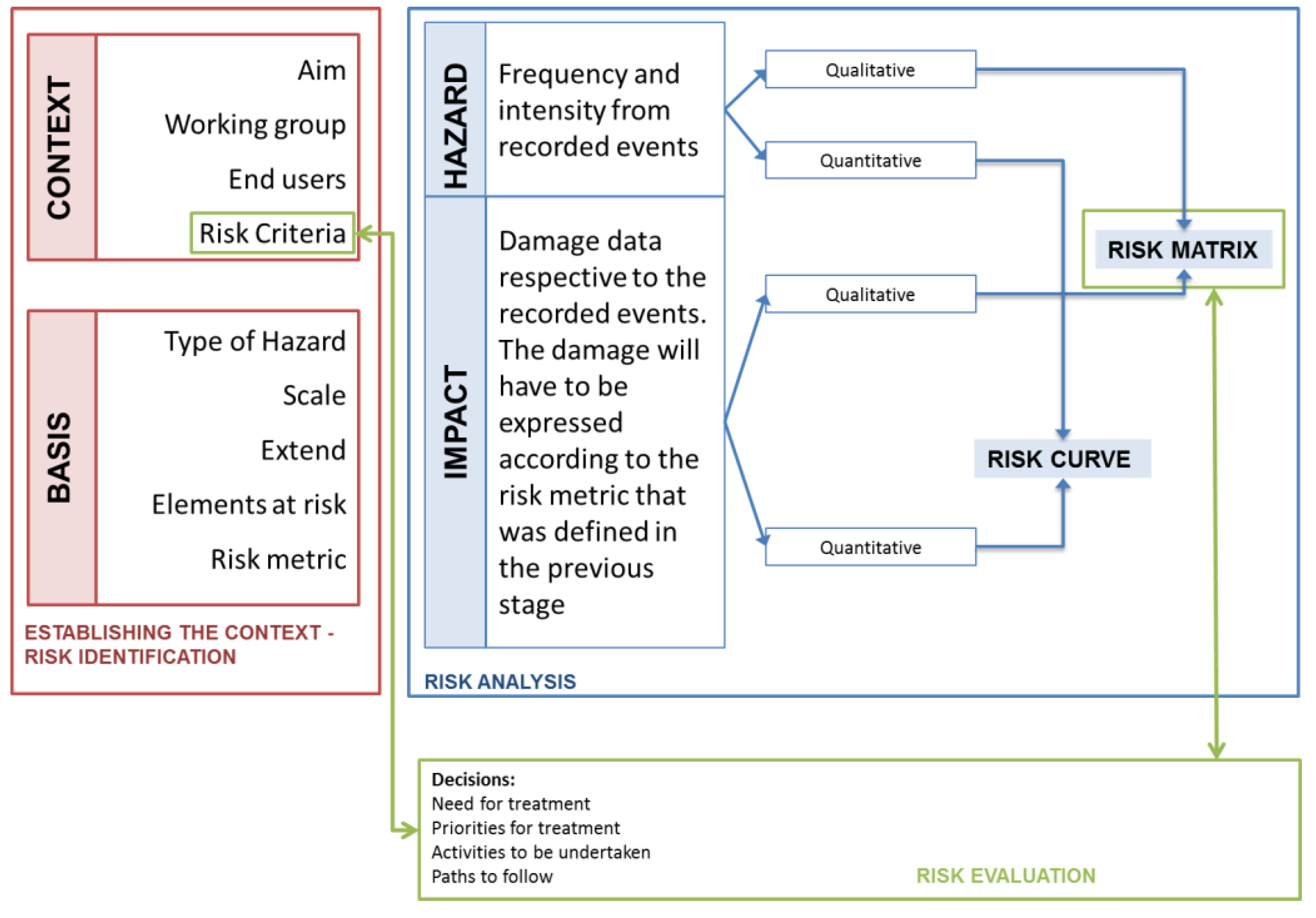
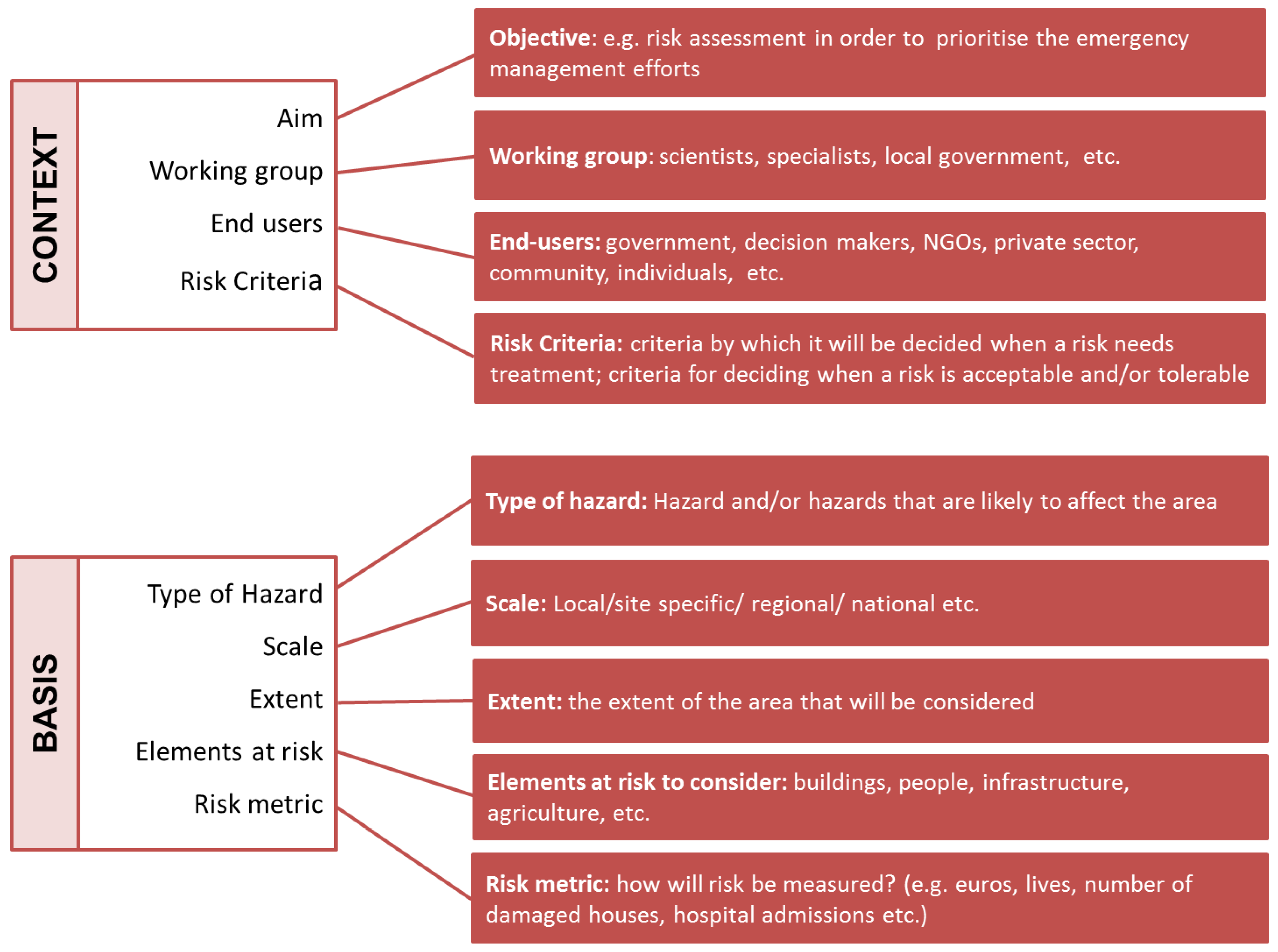
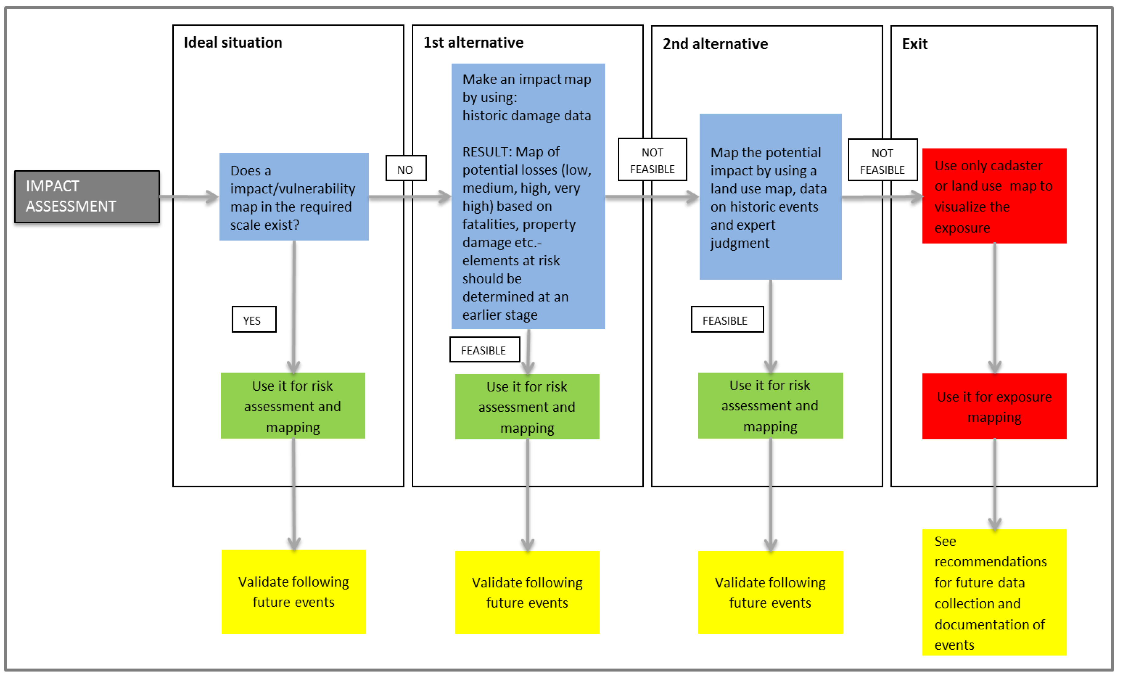
4.1. Risk Identification

The first step of the risk assessment process is the risk identification. The risk identification is the part of the process where the user identifies the context and the basis of the risk assessment as it is shown in Figure 3.
Figure 3. Detailed description of risk identification [46].
Climate 04 00008 g003
One of the most important pieces of information and decisions that the end-user is required to make at this stage is the aim of the risk assessment, which is strongly connected to the elements at risk that will be considered and the risk metric.

4.2. Risk Analysis

The risk analysis is the most significant part of the risk assessment process as far as time and effort are concerned, and it is also the part with the highest demand for data. Risk analysis is “the process to comprehend the nature of risk and to determine the level of risk” [26,47]. The risk analysis may be qualitative, where risk is described as high, medium, or low, or quantitative, where risk is described as a specific previously-defined risk metric (e.g., costs in €, number of potential victims, etc.). The qualitative and quantitative risk assessment procedures are described in the following paragraphs.

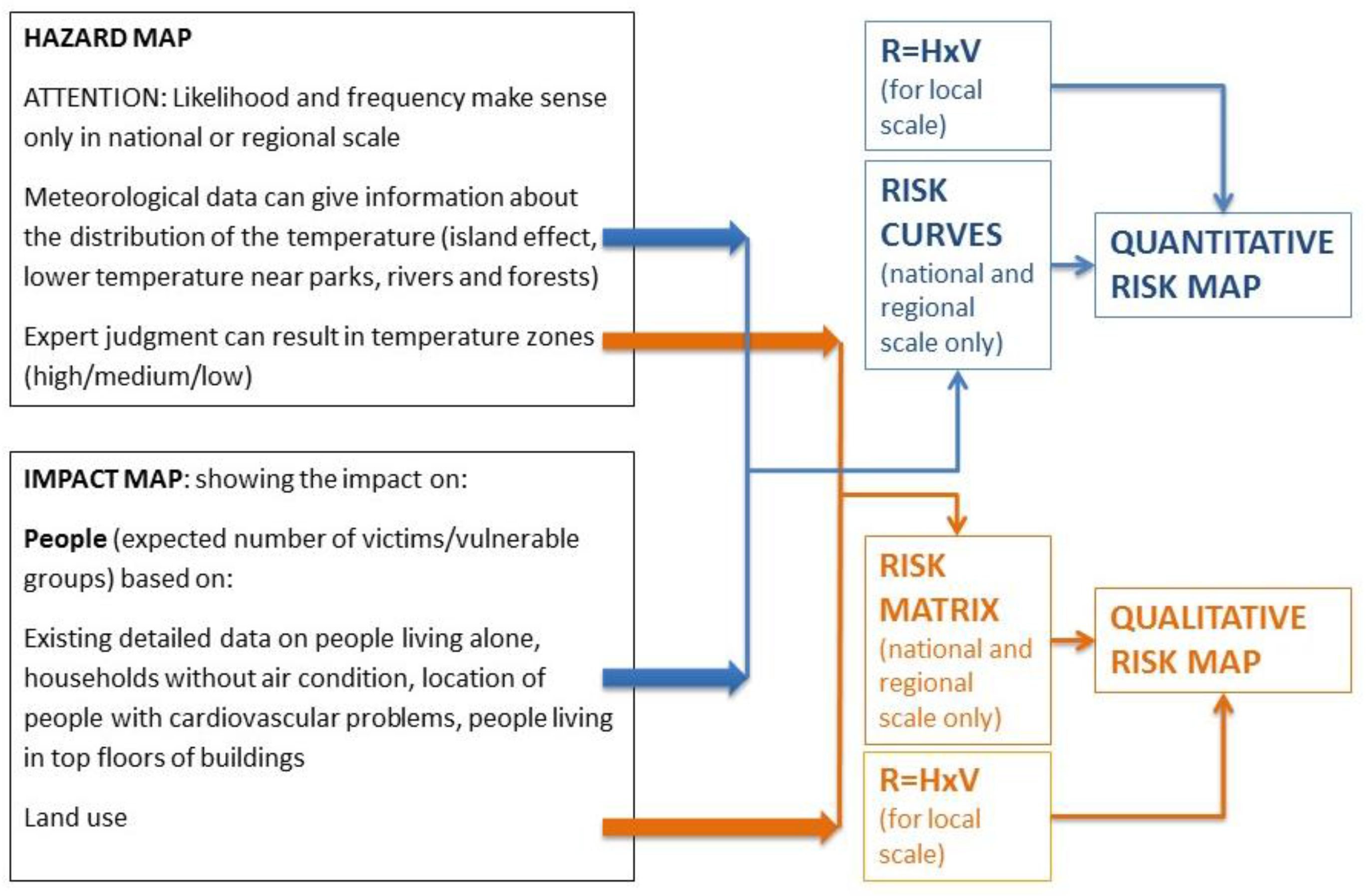
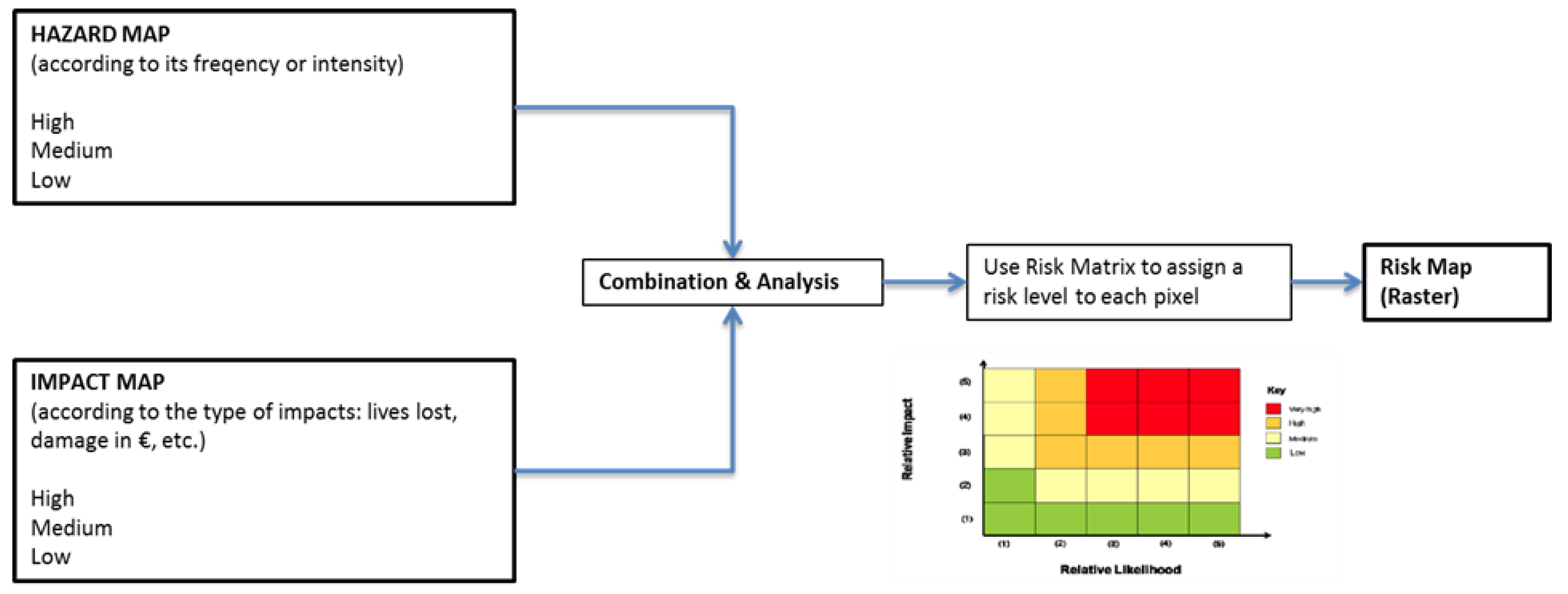
4.2.1. Qualitative Risk Analysis—the Risk Matrix

The basis of the qualitative risk assessment is the development of a risk matrix. The risk matrix demonstrates all the decisions that have been taken in the risk identification phase and also indicates the risk criteria, as the end-user will have to decide what high, medium, and low risk is. Past events may be depicted on the risk matrix to facilitate these decisions. Finally, the risk matrix is used as an index for the risk mapping.
The risk matrix combines three kinds of information: (a) information regarding the hazard (probability), (b) information regarding the impact (consequences), and (c) information regarding the risk criteria of the end-user (high, medium, low risk). Information regarding the hazard and the impact is normally based on historical information and the documentation of past events. Risk criteria, however, should be set by the working group in the first step of the risk assessment (risk identification) process. This step is also relevant to the third stage of the risk assessment process: the risk evaluation. At this stage, the decision-makers have to decide which risks they are going to accept and which ones they are going to treat. In order to confirm the reliability of the risk rating, past disastrous events can be depicted on the risk matrix (according to their probability and impact). The decision-makers may, then, decide if the assigned risk rating is realistic or not.
The general flow of the qualitative risk analysis is shown in Figure 4. The qualitative risk analysis includes the qualitative assessment of hazard and impact showing the spatial distribution of probabilities and consequences expressed in absolute numbers rather than descriptions.
Figure 4. Qualitative risk analysis and mapping procedure [46].
Climate 04 00008 g004
Figure 5 shows the general workflow for qualitative hazard assessment and mapping. If a relevant hazard map in the required scale is already available, it can be directly used for risk mapping. If not, the probability of intensity of a hazard may be expressed in qualitative terms by using information from historic events to define the probability of occurrence (high, medium, low) for different locations of the study area (alternative 1). The resulting hazard map can be used for risk mapping. If data on previous events are not available unreliable or incomplete, then expert judgment is needed to identify low, medium, and high hazard zones in the study area (alternative 2). A raster map of the area can be developed according to the hazard level. If the development of a hazard map in this way is not possible, the methodology offers an exit strategy. However, it should be made clear that the exit strategy does not lead to the development of a risk map. The exit strategy prompts the user to consider the whole administrative unit or area of interest and to perform only impact consequence mapping. Although an impact map is not a risk map, it may still provide important spatial information that may be used by the authorities and decision-makers. If the production of a hazard map is possible, the expert can move on to the next step of the risk assessment and mapping which is the impact analysis. However, the existing hazard map should be evaluated and improved by considering data from new events. In case no data is available for the development of a hazard map, the experts should ensure that future hazardous events will be thoroughly recorded. In this way, adequate data will be available in the future for the development of a detailed hazard map.
Figure 5. Qualitative hazard assessment using alternative steps [46].
Climate 04 00008 g005
In the same way, impacts may be assessed and mapped by using alternative steps, according to the data availability. In case an impact or a vulnerability map is already available, the map may be used directly, together with the hazard map for risk mapping. If not, an impact map has to be developed (alternative 1) by using damage information from past events or information regarding the vulnerability of the elements at risk. The element at risk under investigation (e.g., people) and the risk metric (e.g., lives lost) should have already been defined in the early stage of the risk assessment process. In this way, a map of potential losses can be made and the raster map of the study area can be attributed accordingly (high, medium, low). However, if historical information is not available, a similar map can be developed based on expert judgment (alternative 2) and on land-use data and information. The exit strategy in this case proposes the use of a land use map (e.g., in the case of human casualties: residential areas—high, commercial areas—medium, industrial areas—low) that leads to exposure mapping. The final impact map has to be validated and updated in the future and in case the exit strategy has been used, improved data collection techniques regarding damages of hazardous events have to be adopted (Figure 6).
A qualitative approach to hazard, impact, and risk assessment is often preferred due to data limitations. The qualitative assessment may involve high levels of uncertainty that have to be identified. Moreover, the results of such a risk assessment are difficult to use for comparing two sites, since the assessment of risk based on expert judgment is subjective.

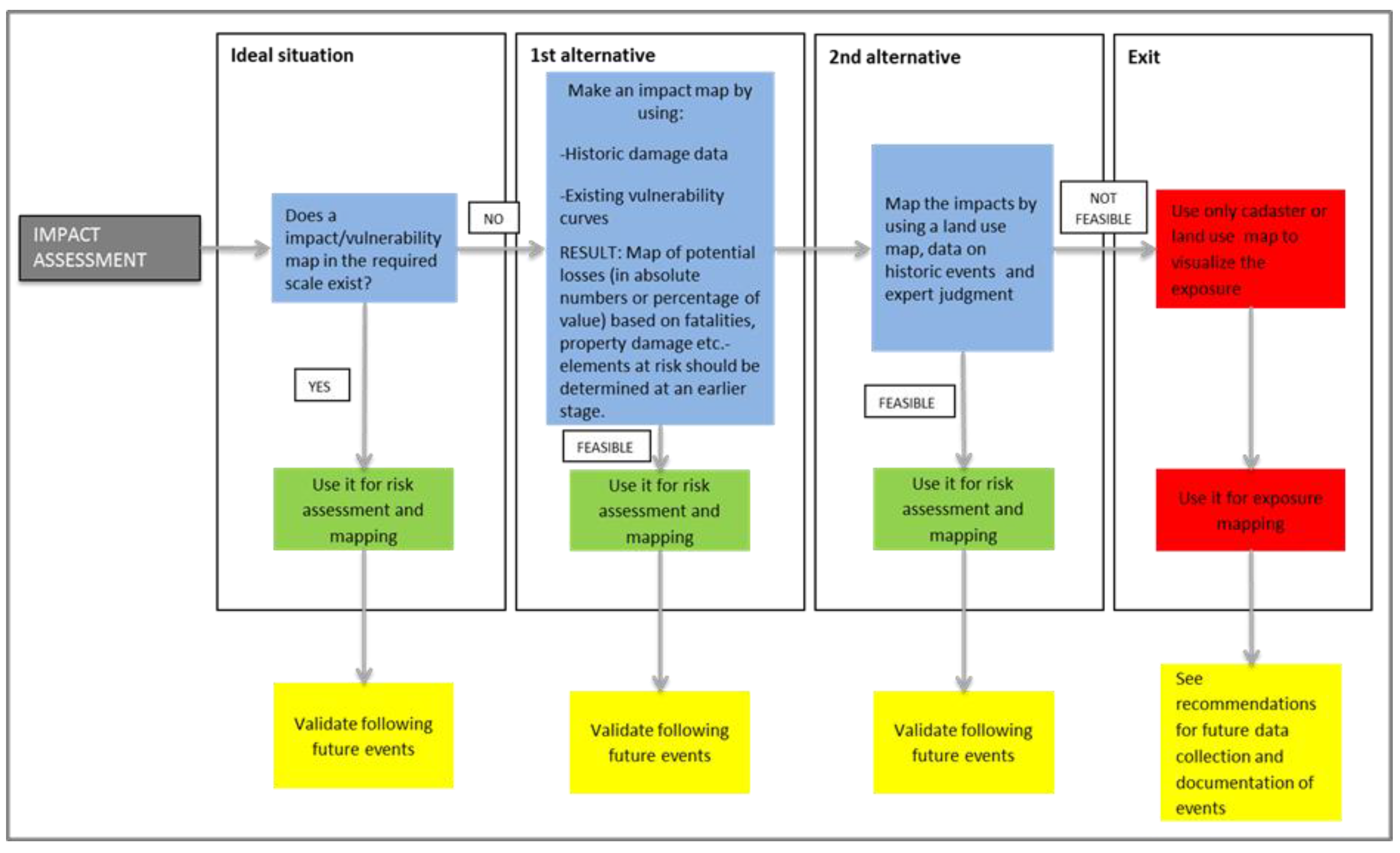
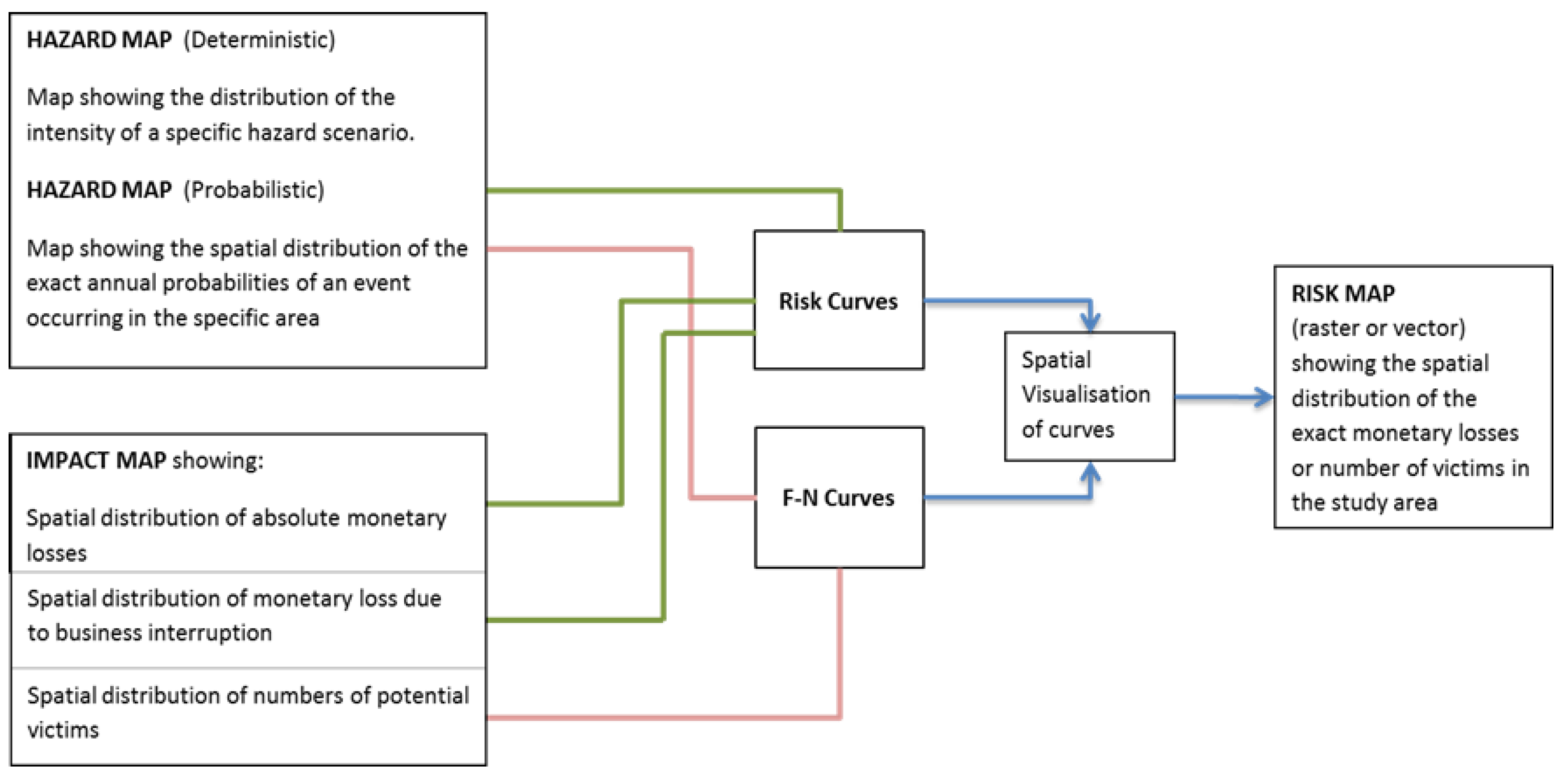
4.2.2. Quantitative Risk Analysis

In case data regarding past events are available in quantitative form, the development of a quantitative risk map is possible. If not, the workflow is similar to the one described for qualitative risk assessment and mapping. The end-user can use the alternative steps if the necessary data are not available. Similar to the qualitative risk assessment and mapping process; first, a map indicating the spatial distribution of probability and intensity levels has to be developed. The second step involves the development of a map demonstrating the spatial pattern of potential impacts in the study area.
Figure 6. Qualitative impact assessment using alternative steps [46].
Climate 04 00008 g006
Figure 7 demonstrates the general flow of a quantitative risk analysis and mapping procedure. The different steps (hazard assessment and mapping and impact assessment and mapping) are demonstrated in Figure 8 and Figure 9. The hazard and impact assessment and mapping in this case is also implemented by using alternative steps in exactly the same way it was implemented in the qualitative risk assessment. In the quantitative hazard mapping procedure, modelling an event may be possible if the required data are available. The hazard modelling may lead to a map showing the exact distribution of probabilities and/or intensities (e.g., a flood extent map showing the flood extent for different return periods).
Whilst quantitative risk assessments have a high detailed data demand, they may be used for cost-benefit analysis, they allow direct comparison between areas and they enable the identification of tolerable and acceptable risk, since this can be expressed in monetary terms (expected costs) or numbers (e.g., number of people affected).
Figure 7. The quantitative risk analysis and mapping procedure [46].
Climate 04 00008 g007
Figure 8. Quantitative hazard assessment using alternative steps [46].
Climate 04 00008 g008
Figure 9. Quantitative impact assessment using alternative steps [46].
Climate 04 00008 g009

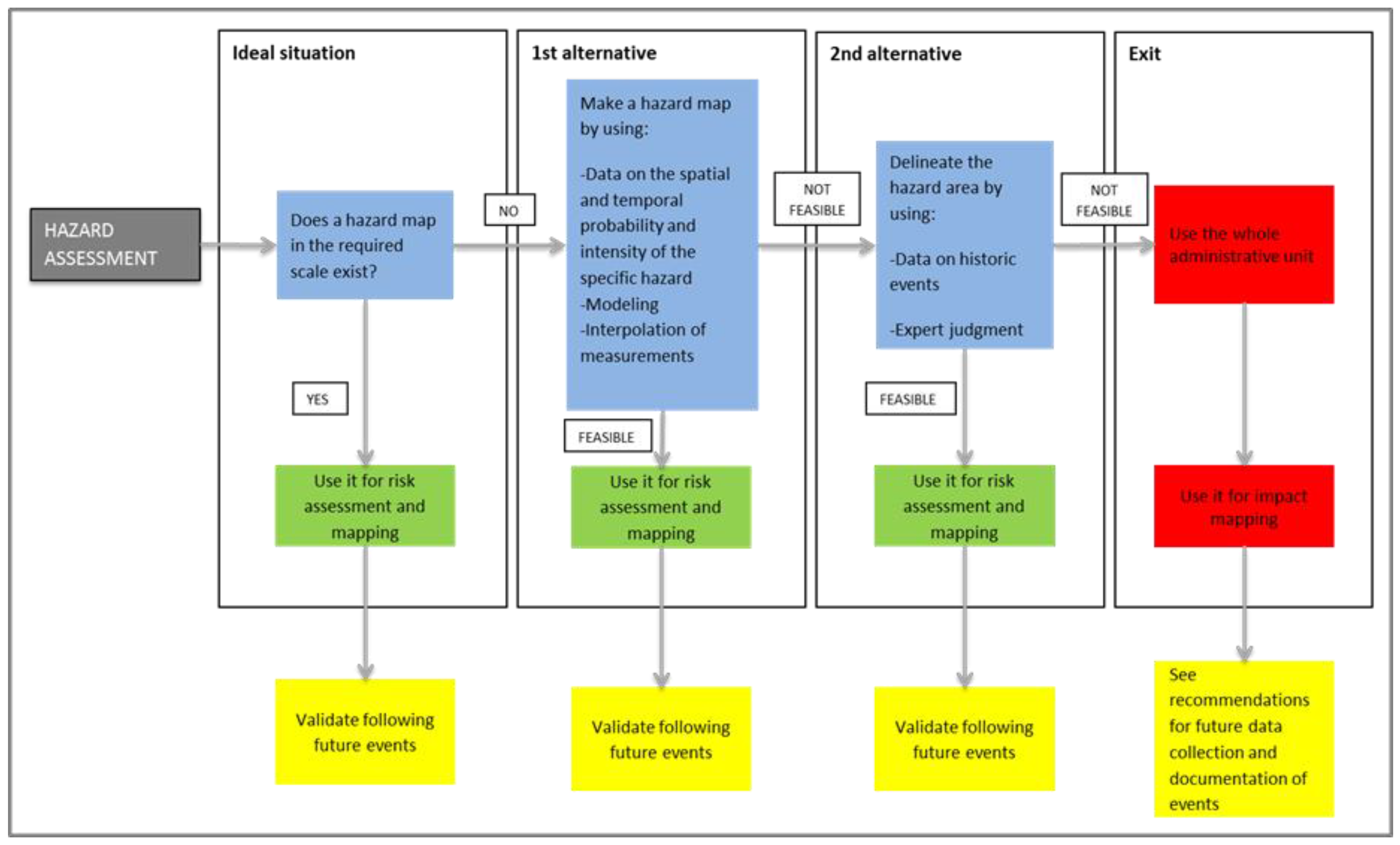
4.3. Risk Evaluation

The steps of the risk assessment procedure do not take place successively in time, but are usually implemented simultaneously. For example, the risk evaluation procedure has to start during the risk identification process. In more detail, the working group implementing the risk assessment will have to define the risk assessment criteria in order to identify a risk as high, medium, or low. Then, decisions have to be made regarding the acceptance of the different risk levels. The risk levels have to be translated into actions. For example, after which risk level will the authorities be alerted or be engaged in specific activities? Which risks are society and the authorities prepared to accept without the implementation of risk reduction measures?

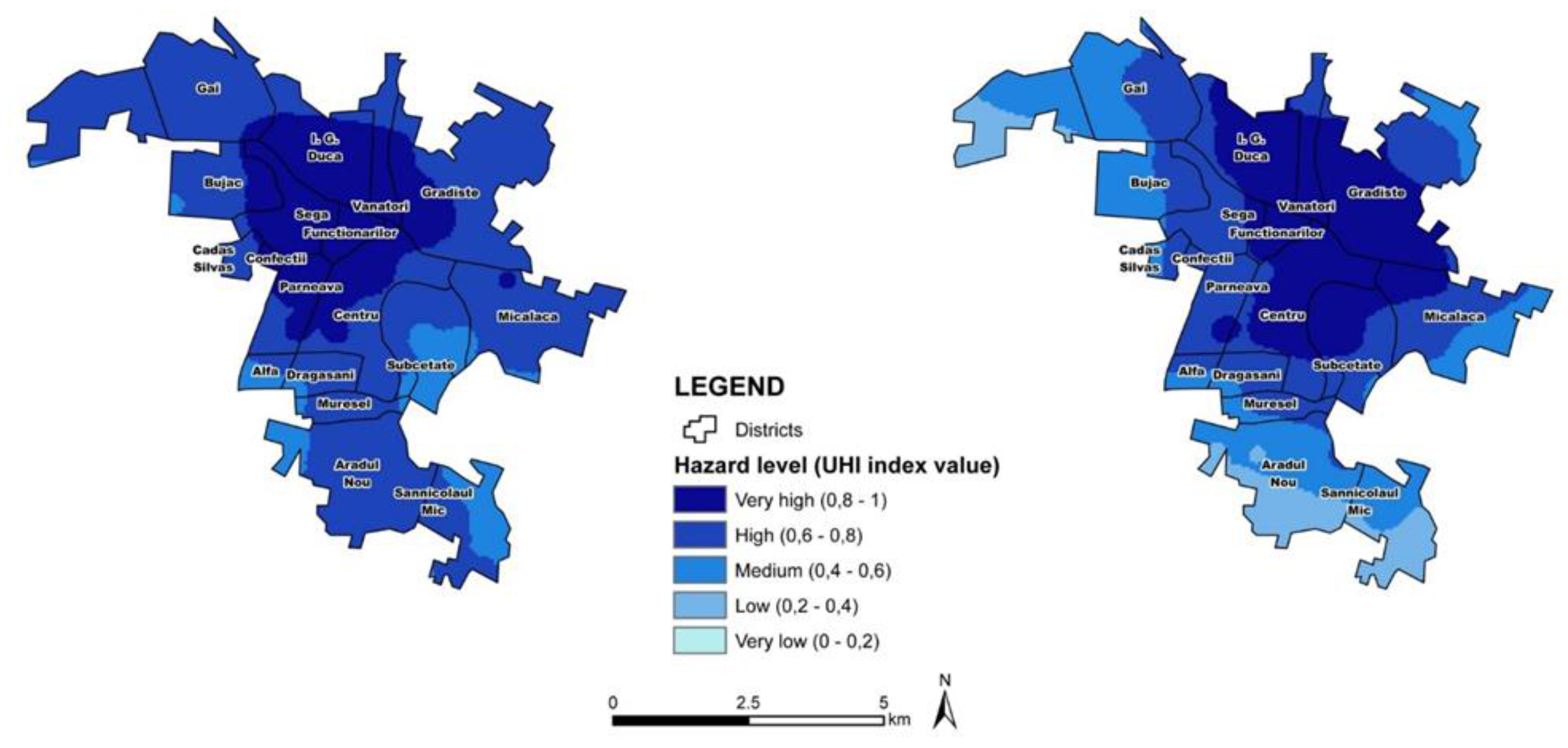
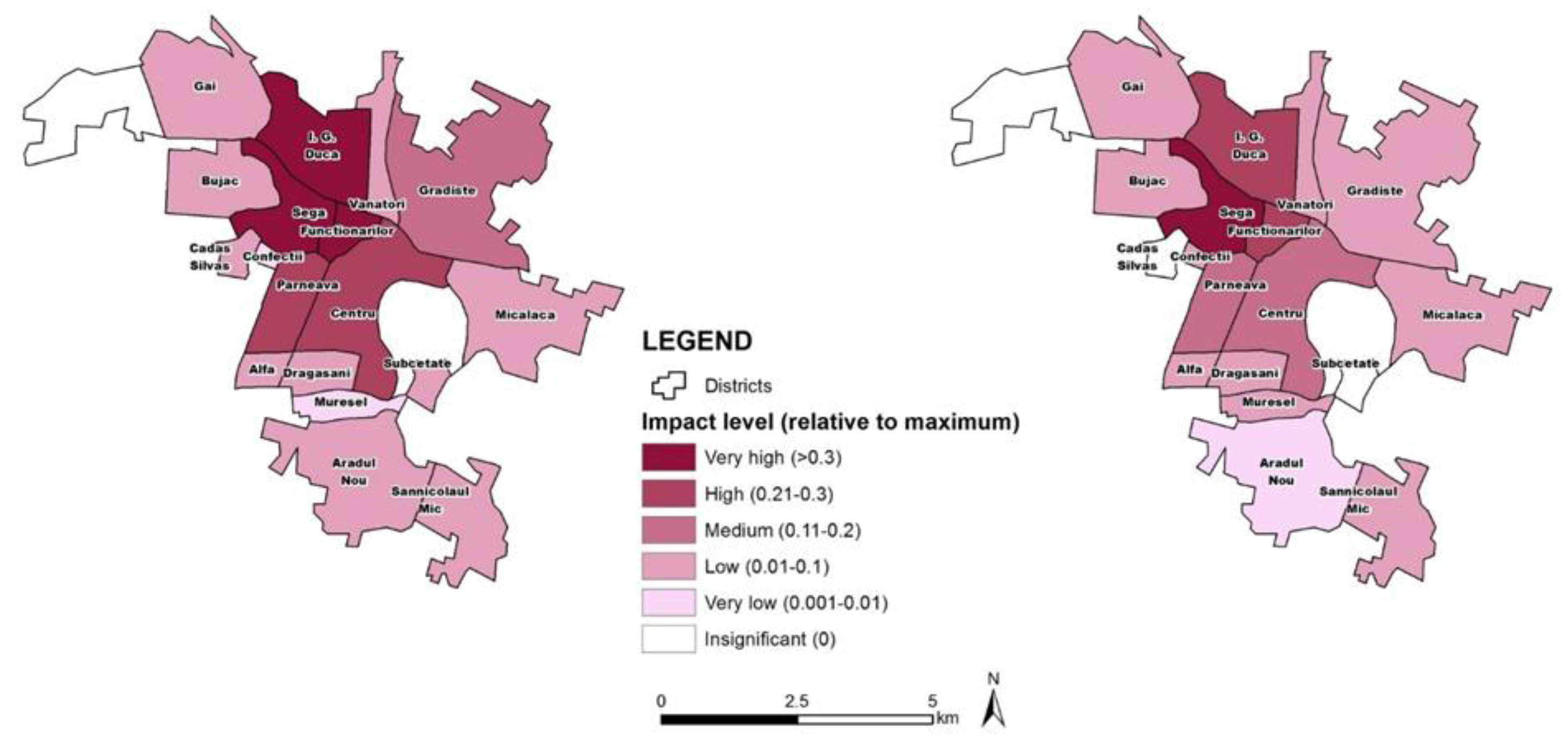
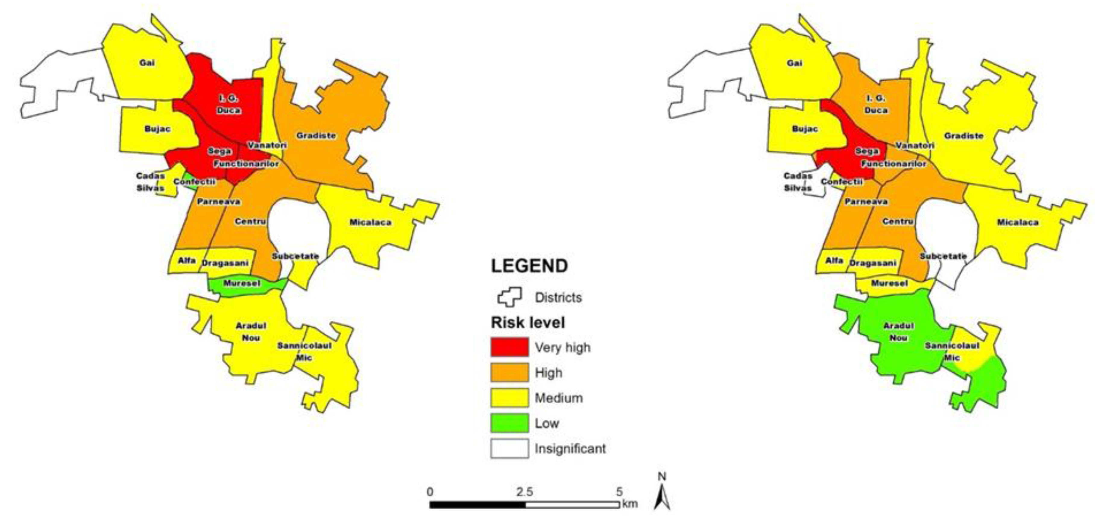
4.4. Case Study Application for Specific Hazards

The common methodology was developed first in a neutral form that could be interpreted and adapted for specific natural hazard types. Within the SEERISK project this adaptation took place for the following hazard types in order to facilitate the application of the methodology in the pilot areas: heat wave, drought, flood, extreme winds, and wildfires. Figure 10 demonstrates the methodology adapted for heat waves.
Figure 10. The CRAM adapted for heat waves [46].
Climate 04 00008 g010
In this paper only the pilot study for heat waves is described in detail. The methodology was applied for heat wave risk in the municipality of Arad in Romania. Based on data regarding surface temperatures of past heat waves and the corresponding number of medical emergency interventions, a risk matrix, a hazard (Figure 11), and an impact map (Figure 12) were developed for day and night time scenarios. Using the risk matrix and the resulting maps a risk map was developed indicating the districts where heat wave risk is higher (Figure 13) [50].
Figure 11. Heat wave hazard in the municipality of Arad (Romania) for day (left) and night time (right) [50].
Climate 04 00008 g011
Figure 12. Impact mapping in the municipality of Arad (Romania) for day (left) and night time (right) [50].
Climate 04 00008 g012
Figure 13. Heat wave risk mapping in the municipality of Arad (Romania) for day and night time [50].
Climate 04 00008 g013
Apart from highlighting the districts were efforts for where the mitigation of heat wave impacts on the population should be intensified, the maps also indicate the areas where adaptive measures have to be considered and implemented in the long term. It is important to point out that districts suffering from the same level of an urban heat island do not necessarily demonstrate the same impact level during the heat wave. This has to be further investigated by considering differences between the social characteristics. Measures for the mitigation of the heat island effect in the districts indicated by the hazard maps may include an increase of green space, reduction of soil sealing, provision of shaded spaces (e.g., shaded pavements for pedestrians), redirection of traffic during hot days, etc. On the other hand, areas where the impact is higher should be considered for awareness raising, funding for better insulation and provision of air-conditioning for the local population. The risk maps may also be used by the local authorities in order to identify locations for shelters with air conditioning for local people in the areas where the risk is high. Moreover, the rescue teams may use the maps in order to identify locations with higher need for intervention during the days of the heat wave and plan their actions more effectively [50].

5. Discussion

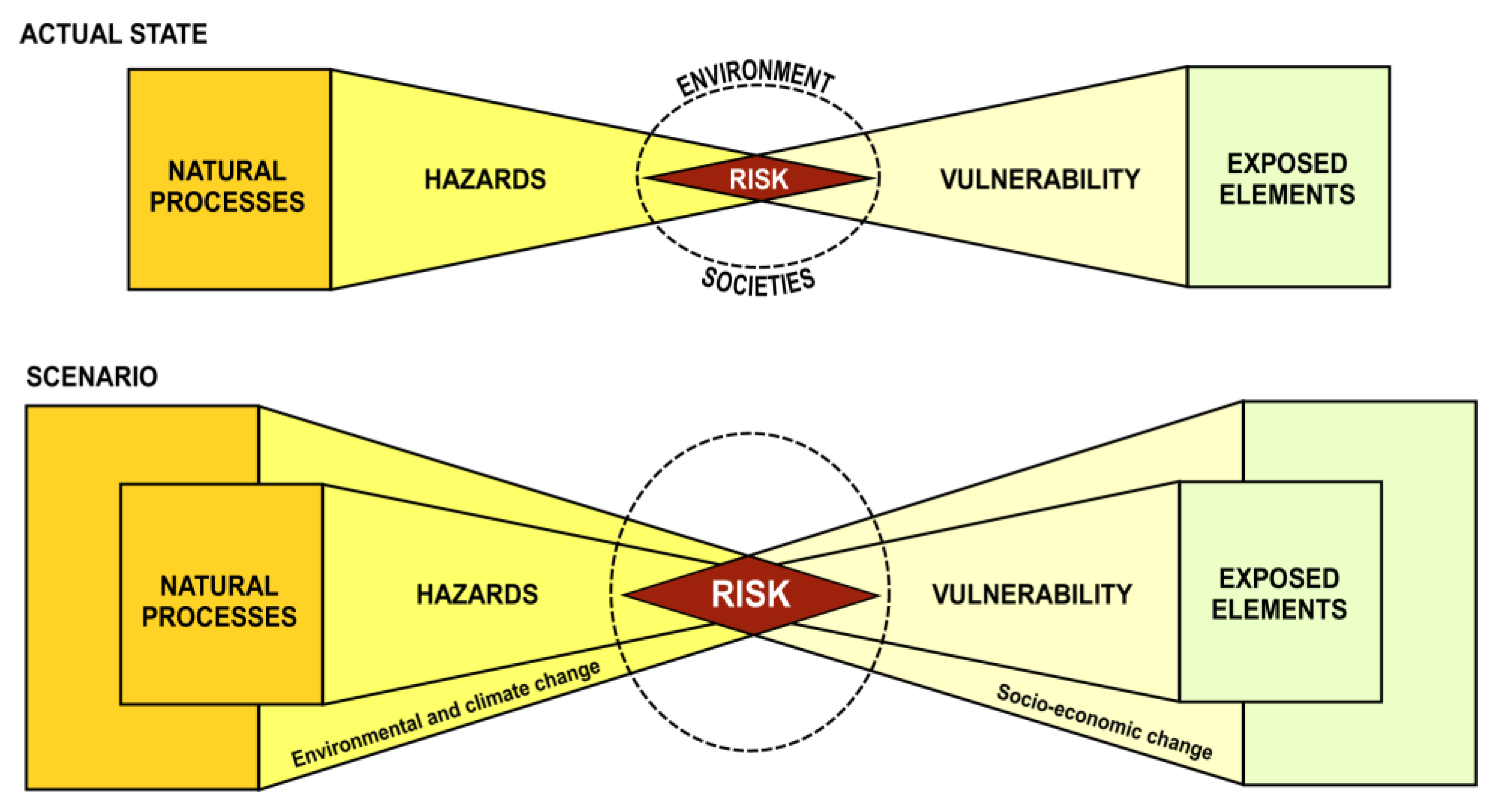
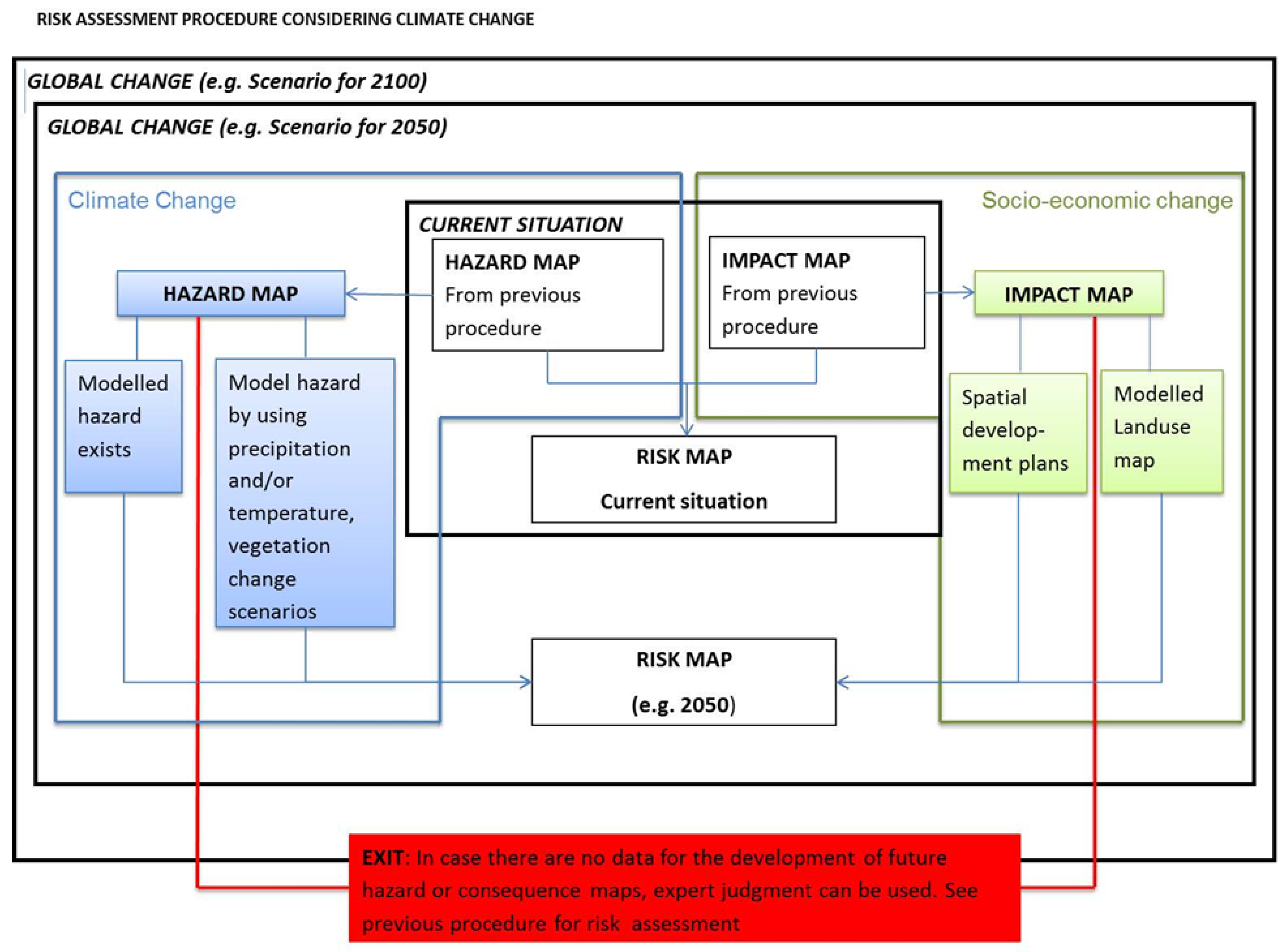
5.1. Extension of CRAM to Include Scenario Analysis

The main difference between risk assessment and climate adaptation approaches is that the first one is dealing with existing risks and often ignores future scenarios that are the main concern of the second one [25]. In the present study a final step is included in the CRAM that allows the risk assessment for future scenarios. In this step not only climate change but also changes in the socio-economic context are considered. In order to produce a risk map for a specific event for the future (e.g., 2050) climate scenarios have to be considered directly (e.g., changes in temperature directly connected to a heat wave) or indirectly (changes in precipitation indirectly connected to floods). However, as is clearly indicated in Figure 14, changes in the socio-economic context, by using modelling or existing spatial development plans, have to be considered in order to develop a future impact map. In the absence of such data an exit option using expert judgment is available. The main drawback at this stage is not only the lack of data but also the scarcity of climate data at the local scale. Most projections for temperature and precipitation are available only at the European or global scales. Downscaling such data to the local level is an issue that needs more investigation.
Figure 14. Consideration of global change for future risk assessment [46].
Climate 04 00008 g014
The risk maps for future scenarios may be used for cost benefit analysis of structural mitigation measures. The potential future spatial vulnerability pattern may be used as an indication for expected future losses and investment needs in specific areas, or as the basis for the implementation of public awareness and education programs. Moreover, the future spatial pattern of hazards will enable decision-making regarding structural measures, land use, and spatial planning decisions and building codes. Risk mapping for future scenarios requires a high amount of data that are rarely available. The exit option allows the development of a risk map based on expert judgment. It is important that in this case the uncertainties related to this map are listed, explained and, if possible, quantified.

5.2. Benefits and Contribution

Although the study was carried out using a number of assumptions that raise the level of uncertainty, the advantages of the method outweigh the disadvantages. The development of the methodology brought authorities and agencies of SEE countries together. They harmonized their understanding of natural hazards and risks and they adopted a method that may enable them to assess and visualize the risks in their countries by using the data that they have available. By using the same “language” and the same methodology, a trans-boundary risk assessment (which was not implemented in this case study), may be possible in the future. The methodology and its application in study areas raised awareness not only regarding the existing risk, but also concerning the future spatial patterns. The resulting maps may act as bases for climate change adaptation strategies in each case study area. The innovative aspect of the methodology is mainly the event tree analysis procedure that leads the user through a stepwise methodological framework. The framework offers alternative steps when a step is not possible due to lack of pre-existing maps/products or data. The last step is the “exit option” which offers the user the possibility to visualize the impact or the possible extent of an event but not the spatial pattern of risk. Although the “exit option” is not ideal, it still offers an overview of what may happen and may still be used to guide some actions related to preparedness, emergency planning, or mitigation. Last, but not least, the methodology offers a feedback loop that supports self-improvement of the methodology. The methodological framework encourages the users to validate their risk maps using new data emerging during future events offering at the same time suggestions for better documentation in the future so that the problem of inadequate and limited quantities of data will slowly improve. The contribution of the framework in the field of CCA and DRR is demonstrated through its ability to address decision-makers without requiring a high expertise or knowledge of technical terms. The methodology is making use of local knowledge and expert judgment, and it forms a common working platform for interdisciplinary experts contributing in this way to the linkage between DDR and CCA. It encourages communities and authorities not only to conduct risk assessment but also to improve their data quality in the future. It raises awareness among decision-makers and other end-users regarding climate change related risks and gives the opportunity to develop future risk scenarios.

5.3. Limitations and Future Perspectives

The study presented herein was carried out despite numerous limitations that have partly hindered its implementation. These limitations may be divided in two categories:
  • limitations related to the development of the methodology, and
  • limitations related to the implementation of the methodology in the pilot areas.
The limitations related to the methodology included differences in the understanding of terms by the end-users that were partially overcome by the provision of a glossary. Moreover, there were differences in the existing legal frameworks of each partner. For example, in Serbia, a methodology at the national level is available which has significant differences with the CRAM. However, non-EU countries like Serbia do not have to comply with EU legislation, directives, or recommendations. This would not be a problem if hazards were contained within national borders. However, this is not the case. Heat waves, floods, and drought (only to name a few) cross administrative and national borders and may have a negative impact on larger areas. In order for countries to work together and develop strategies for risk reduction, understanding and the methodological approaches should be harmonized. This is particularly difficult between EU and non-EU countries. Even for EU countries with different national legislation this may be very difficult. In this respect, although the CRAM contributed to some harmonization and communication between different countries, no trans-boundary risk assessment was implemented. Moreover, although the CRAM promises the consideration of future changes into the development of future risk scenarios, it is based on information on past events.
The main limitation of the implementation of the methodology was the lack of data. The lack of data is mainly attributed to inadequate or non-existing documentation of past events. The user is often prompted to use expert judgment that raises the level of uncertainty. Uncertainties may be related to the probability of the hazard and the return periods, the extent of natural processes, like floods, the expected degree of loss of the element at risk, and their characteristics. Moreover, expert judgment leads to qualitative results that, due to their subjectivity, are very difficult to compare with data from different case studies. Uncertainties may be reduced by increasing the number of experts, however some challenges still remain. For example, qualitative spatial data are difficult to upscale or downscale since the level of uncertainty will increase. For example, the assessment of an expert regarding the flood extent in a specific catchment may not be up-scaled to the regional level since the assessment has been based on local knowledge and experience. Comparing results between different case studies may also lie on different scale and units used as well as different aims and risk metric. The methodology is based on knowledge of past events as this is necessary in order to assess the probability of occurrence and to have an overview of potential costs. However, it is necessary to include future climate and socio-economic changes for the development of future risk scenarios. Nevertheless, the step towards future risk assessment and mapping is difficult to implement. As there are no climate projections available at the local scale, global climate projection (or regional if available) will have to be downscaled to the local level. There are several methods for downscaling climate change projections [51], however, this is a process that requires adequate technology, experts, and data, which is not always available. Moreover, in cases where data was available, these were not available from the same authority (a bureaucratic procedure was necessary) or they were not free of charge. Moreover, the required data were often available in analog format, or the geographic dimension was missing (e.g., building directories in lists but without geographical location). Another drawback is also the lack of technology (GIS software, computers, etc.) and the lack of experts and qualified personnel. Furthermore, an alternative of collecting data may be ruled out in some cases due to time constraints. Additionally, risk assessment requires the co-operation of a number of experts, cross-sectional collaboration and coordination that may put the organizational capacities of some authorities to the test. Last, but not least, the satisfactory implementation of the model and its contribution to the improvement of risk preparedness depends also on the social characteristics and awareness of the communities involved as well as the institutional preparedness. For this reason, a separate study has been carried out in parallel, focusing on the assessment of the public awareness and preparedness and the risk perception of the communities in the case study areas of the SEERISK project. Additionally, the study focuses on aspects related to the institutional preparedness of these communities such as, information flow form the authorities to the public, human, and financial capacity, etc. The results of this study may be also found in the “Guideline on climate change adaptation and risk assessment in the Danube macro-region” [46].
Recommendations for future documentation of events and their consequences at the local level is also included in the “Guideline on Climate change adaptation and risk assessment in the Danube macro-region” [46] in order to help local authorities with data collection following disastrous events. In this way, a database for hazard and impact data may be built which can be used in the future for risk assessment with less uncertainty. Additionally, the use of the methodology for cross-border risk assessment is a significant potential development of the methodology. Since most of the climate change related hazards often affect more than one country (e.g., heat waves), or cross border areas (floods), the CRAM has to be tested in adequate case studies. Finally, the last step of the methodology also has to be applied. The methodology has to be applied with the consideration of climate and socio-economic changes and risk maps showing the spatial pattern of future risk have to be developed. Finally, alternative adaptation strategies based on these future risk scenarios have to be considered.

6. Conclusions

Developing a common risk assessment methodology that is scientifically sound and, yet, uncomplicated enough to be used by different users, for a variety of hazard types and for various elements at risk is a very challenging task. Each country has different legal requirements and different types of hazards to deal with and, thus, different needs and expectations. Moreover, the financial and political context, as well as data availability, vary significantly. However, the methodology developed and presented herein contributes significantly to overcoming these obstacles. The methodology has taken steps towards a harmonized approach to risk assessment in the sense of using the same “language” (a glossary is also provided) and the same procedure (risk identification, analysis, and risk evaluation), as well as the internal steps of each phase (common templates for the development of risk scenarios and risk matrices). The CRAM may be considered as a “process tool”, enabling the process of risk assessment, rather than a technical output which gives exact instructions leading to a specific result. The option of alternatives does enable the users to do the best with what is available. Additionally, the problem of missing data is confronted through recommendations for better damage documentation. New ways of documenting events have to be adopted, and technology has to be employed, for rapid damage assessment following catastrophic events. Hazard consequences have to be documented in the right scale and detail in order to be used for creating future scenarios and also for investigating the impact of natural processes on elements at risk in order to design sufficient mitigation measures. Furthermore, communication between agencies has to be improved. In this way, existing data may become available for more users and may be used for the implementation of DRR strategies. The methodology considers climate and socio-economic changes. This raises awareness about the changing environment and the increased risk in the future among authorities and decision makers, supporting in this way DRR activities and CCA strategies. For this reason, the partners of SEERISK are disseminating the methodology through national platforms for climate change adaptation. Moreover, the methodology enables the development of risk maps in areas where, until now, this was impossible. These maps, although they contain a certain level of uncertainty, may form the basis for the development of climate change adaptation strategies and may raise awareness among the public regarding emerging hazards and risks. The methodology has space for improvement and refinement, but this can only be done through its use and application in different places and for different hazards and elements at risk.

Acknowledgments

The research presented in this chapter was carried out within the framework of the project SEERISK (Project code: SEE/C/0002/2.2/X) funded by SEE (South East Europe Transnational Cooperation Programme). The authors would like to thank the SEERISK consortium for their feedback at earlier stages of the methodology development. Dale Dominey-Howes is thanked for his constructive comments on previous versions of the paper and his valuable contribution in the final editing of the text. Finally, the authors would like to thank the three anonymous referees and the editor for their comments and suggestions.

Author Contributions

Maria Papathoma-Köhle and Catrin Promper developed the presented methodology and adapted it for several types of climate related hazards with the scientific support from Thomas Glade. The main author of the paper was Maria Papathoma-Köhle, however, Catrin Promper and Thomas Glade gave significant feedback to the present paper.

Conflicts of Interest

The authors declare no conflicts of Interest.

References

  1. Centre for Research on Epidemiology of Disasters (CRED). CRED Annual Disaster Statistical Review; University of Louvain: Brussels, Belgium, 2008. [Google Scholar]
  2. Dominey-Howes, D. Explainer: Are Natural Disasters on the Rise? The Conversation. Available online: https://theconversation.com/explainer-are-natural-disasters-on-the-rise-39232 (accessed on 23 November 2015).
  3. International Strategy for Disaster Reduction (ISDR). Terminology on Disaster Risk Reduction; UNISDR: Genève, Switzerland, 2009. [Google Scholar]
  4. Intergovernmental Panel for Climate Change (IPCC). Climate Change 2014 Synthesis Report Summary for Policymakers; Cambridge University Press: Cambridge, UK, 2014. [Google Scholar]
  5. Intergovernmental Panel for Climate Change. Managing the Risks of extreme Events and Disasters to Advance Climate Change Adaptation. A special report of Working groups I and II of the Intergovernmental Panel on Climate Change; Field, C.B., Barros, V., Stocker, T.F., Dahe, Q., Dokken, D.J., Ebi, K.L., Mastrandrea, M.D., Mach, K.J., Plattner, G.K., Allen, S.K., et al., Eds.; Cambridge University Press: Cambridge, UK, 2012; p. 582. [Google Scholar]
  6. Alcantara-Ayala, I.; Altan, O.; Baker, D.; Briceno, S.; Cutter, S.; Gupta, H.; Holloway, A.; Ismail-Zadeh, A.; Jimenez Diaz, V.; Johnston, D.; et al. Disaster Risks Research and Assessment to promote Risk Reduction and Management; ICSU: Paris, France; p. 49.
  7. Lei, Y.; Wang, J. A preliminary discussion on the opportunities and challenges of linking climate change adaptation with disaster risk reduction. Nat. Hazards 2014, 71, 1587–1597. [Google Scholar] [CrossRef]
  8. Gero, A.; Méheux, K.; Dominey-Howes, D. Integrating community based disaster risk reduction and climate change adaptation: examples from the Pacific. Nat. Hazards Earth Syst. Sci. 2011, 11, 101–113. [Google Scholar] [CrossRef]
  9. Gero, A.; Méheux, K.; Dominey-Howes, D. Integrating disaster risk reduction and climate change adaptation in the Pacific. Clim. Dev. 2011, 3, 310–327. [Google Scholar] [CrossRef]
  10. International Strategy for Disaster Reduction. Adaptation to Climate Change by Reducing Disaster risks: Country Practices and Lessons; Briefing Note 02; UNISDR: Genève, Switzerland, 2009. [Google Scholar]
  11. Mekong River Commission. Review of Climate Change Adaptation Methods and Tools; MRC Technical Paper No. 34; Mekong River Commission: Vientiane, Laos, 2010. [Google Scholar]
  12. Hare, M.C.; van Bers, J.M. (Eds.) A Best Practices Notebook for Disaster Risk Reduction and Climate Change Adaptation: Guidance and Insights for Policy and Practice from the CATALYST Project; TWAS: Trieste, Australia, 2013.
  13. Deutsche Gesellschaft für Technische Zusammenarbeit (GTZ). International Workshop on Mainstreaming Adaptation to Climate Change: Guidance and Tools; GTZ: Berlin, Germany, 2009. [Google Scholar]
  14. Tearfund. Linking Climate Change Adaptation and Disaster Risk Reduction; Tearfund: London, UK, 2008. [Google Scholar]
  15. International Federation of Red Cross and Red Crescent Societies. A Guide to Mainstreaming Disaster Risk Reduction and Climate Change; IFRC: Geneva, Switzerland, 2013. [Google Scholar]
  16. Mitchell, T.; van Aalst, M.; Villanueva, P.S. Assessing Progress on Integrating Disaster Risk Reduction and Climate Change Adaptation in Development Processes; Strengthening Climate Resilience Discussion Paper 2; Institute of Development Studies: Brighton, UK, 2010. [Google Scholar]
  17. Kellett, J.; Caravani, A. Financing Disaster Risk Reduction: A 20 Year Story of International Aid; Global Facility for Disaster Reduction and Recovery (GFDRR) and Overseas Development Institute (ODI): Washington, DC, USA, 2013. [Google Scholar]
  18. O’Brien, K.M.; Pelling, A.; Patwardhan, S.; Hallegatte, A.; Maskrey, T.; Oki, U.; Oswald-Spring, T.; Wilbanks, P.Z.; Yanda, F. Toward a sustainable and resilient future. In Managing the Risks of Extreme Events and Disasters to Advance Climate Change Adaptation; Field, C.B., Barros, V., Stocker, T.F., Qin, D., Dokken, D.J., Ebi, K.L., Mastrandrea, M.D., Mach, K.J., Plattner, G.K., Allen, S.K., et al., Eds.; Cambridge University Press: Cambridge, UK; pp. 437–486.
  19. United Nations. Sendai Framework for Disaster Risk Reduction 2015–2030; UNISDR: Genève, Switzerland, 2015. [Google Scholar]
  20. Birkmann, J.; von Teichman, K. Integrating disaster risk reduction and climate change adaptation: Key challenges-scales, knowledge and norms. Sustain. Sci. 2010, 5, 171–184. [Google Scholar] [CrossRef]
  21. Serrao-Neumann, S.; Crick, F.; Harman, B.; Schuch, G.; Low Choy, D. Maximizing synergies between disaster risk reduction and climate change adaptation: Potential enablers for improved planning outcomes. Environ. Sci. Policy 2015, 20, 46–61. [Google Scholar] [CrossRef]
  22. Begum, R.A.; Sarkar, M.S.K.; Jaafar, A.H.; Pereira, J.J. Toward conceptual frameworks for linking disaster risk reduction and climate change adaptation. Int. J. Disaster Risk Reduct. 2014, 10, 362–373. [Google Scholar] [CrossRef]
  23. European Forum for Disaster Risk Reduction. How Does Europe Link DDR and CCA? UNISDR: Genève, Switzerland, 2013. [Google Scholar]
  24. Mercer, J.; Dominey-Howes, D.; Kelman, I.; Lloyd, K. The potential for combining Indigenous and Western Knowledge in reducing vulnerability to environmental hazards in Small Island Developing States. Environ. Hazards 2007, 7, 245–259. [Google Scholar] [CrossRef]
  25. International Strategy for Disaster Reduction (ISDR). Strengthening Climate Change Adaptation through Effective Disaster Risk Reduction; Briefing Note 03; UNISDR: Genève, Switzerland, 2010. [Google Scholar]
  26. European Commission. Risk Assessment and Mapping Guidelines for Disaster Management; University of Louvain: Brussels, Belgium, 2008. [Google Scholar]
  27. United Nations Disaster Relief Organisation (UNDRO). Disaster Prevention and Mitigation—A Compendium of Current Knowledge; United Nations: New York, NY, USA, 1984. [Google Scholar]
  28. Wisner, B.; Blaikie, P.; Cannon, T.; Davis, I. At Risk: Natural Hazards, Peoples Vulnerabilities and Disasters; Psychology Press: Hove, UK, 2004. [Google Scholar]
  29. European Council. An EU Strategy on Adaptation to Climate Change; European Council: Brussels, Belgium; 2013. [Google Scholar]
  30. European Council. Commission Staff Working Document: Guidelines on Developing Adaptation Strategies; SWD European Council: Brussels, Belgium, 2013. [Google Scholar]
  31. Malet, J.P.; Remaitre, A.; Puissant, A.; Spickermann, A.; Glade, T.; Promper, C.; Petschko, H.; Begueria, S.; Sanchez, G. ChangingRISKS: Changing pattern of landslide risks as a response to global changes in mountain areas. In Proceedings of the CIRCLE2 Climate Impact Research & Response Coordination for a Larger Europe EU FP7 ERA-NET Mid-Term Meeting, Innsbruck, Austria, 29–30 March 2012.
  32. Commission of the European Communities. Green Paper from the Commission to the Council, the European Parliament, the European Economic and Social Committee and the Committee of the Regions-Adapting to climate change in Europe-options for EU Action; European Council: Brussels, Belgium, 2007. [Google Scholar]
  33. ICPDR & ISRBC (International Commission for the Protection of the Danube River and International Sava River basin Commission). Floods in May 2014 in the Sava River Basin: Brief Overview of Key Events and Lessons Learnt; ICPDR & ISRBC: Vienna, Austria, 2015. [Google Scholar]
  34. UNISDR. South Eastern Europe Disaster Risk Mitigation and Adaptation Initiative; Risk Assessment for South East Europe: Desk Study Review; UNISDR: Genève, Switzerland, 2008. [Google Scholar]
  35. UNISDR. Building Resilience to Disasters in Western Balkans and Turkey (Brochure); UNISDR: Genève, Switzerland, 2012. [Google Scholar]
  36. European Council. EU Directive of the European Parliament and of the European Council on the Estimation and Management of Flood Risks (2007/60/EU). European Council: Brussels, Belgium, 2007. [Google Scholar]
  37. CENN/ITC. Atlas of Natural Hazards and Risk Management of Georgia. CENN/ITC: Tbilisi, Georgia, 2012. [Google Scholar]
  38. Varazanashvili, O.; Tsereteli, N.; Amiranashvili, A.; Tsereteli, E.; Elizbarashvili, E.; Dolidze, J.; Qaldani, L.; Saluqvadze, M.; Adamina, S.; Arevadze, N.; Gvencadze, A. Vulnerability, hazards and multiple risk assessment for Georgia. Nat. Hazards 2012, 64, 2021–2056. [Google Scholar] [CrossRef]
  39. Balzer, D.; Jäger, S.D. Guidebook for Assessing Risk Exposure to Natural Hazards in Central America—El Salvador, Guatemala, Honduras, and Nicaragua. BGR: Hannover, Germany, 2010. [Google Scholar]
  40. Danube Floodrisk. Danube Atlas 2012: Atlas of Flood Hazard and Risk Maps of the Danube. ICPDR: Bucharest, Romania, 2012. [Google Scholar]
  41. Haupter, B.; Heiland, P.; Neumüller, J. Interregional and transnational co-operation in river basins—Chances to improve flood risk management? Nat. Hazards 2005, 36, 5–24. [Google Scholar] [CrossRef]
  42. Cechet, R.P.; Sanabria, A.; Yang, T.; Arthur, W.C.; Wang, C.H.; Wang, X. An assessment of severe wind hazard and risk for Queensland’s Sunshine Coast Region. In Proceedings of the International Congress on Modelling and Simulation, Perth, Australia, 12–16 December 2011; pp. 2817–2823.
  43. Jung, J.; Kim, C.; Jayakumar, S.; Kim, S.; Han, S.; Kim, D.H.; Heo, J. Forest fire risk mapping of Kolli Hills, India, considering subjectivity and inconsistency issues. Nat. Hazards 2013, 65, 2129–2146. [Google Scholar] [CrossRef]
  44. Ferrier, N.; Haque, C.E. Hazard risk assessment methodology for emergency managers: A standardized framework for application. Nat. Hazards 2003, 28, 271–290. [Google Scholar] [CrossRef]
  45. Hsu, W.K.; Huang, P.C.; Chang, C.C.; Chen, C.W.; Hung, D.M.; Chiang, W.L. An integrated flood risk assessment model for property insurance industry in Taiwan. Nat. Hazards 2011, 58, 1295–1309. [Google Scholar] [CrossRef]
  46. SEERISK. Guideline on Climate Change Adaptation and risk Assessment in the Danube Macro-Region. NDGDM: Budapest, Hungary, 2014. [Google Scholar]
  47. IEC. FDIS 31010: Risk Management—Risk Assessment Techniques. IEC: Geneva, Switzerland, 2009. [Google Scholar]
  48. Kohler, A.; Jülich, S.; Bloemertz, L. Guidelines: Risk Analysis—A Basis for Disaster Risk Management, German Technical Cooperation GmbH (GTZ); German Federal Ministry for Economic Cooperation and Development (BMZ): Eschborn, Gemany, 2004.
  49. AEMC. National Emergency Risk Assessment Guidelines; Australian Emergency Management Committee, Emergency Tasmanian State Emergency Service: Hobart, Australia, 2010. [Google Scholar]
  50. Papathoma-Köhle, M.; Promper, C.; Bojariu, R.; Cica, R.; Sik, A.; Perge, K.; Laszlo, P.; Balazs Czikora, E.; Dumitrescu, A.; Turcus, C.; et al. A common methodology for risk assessment and mapping for Southeast Europe: An application for heat wave risk in Romania. In Vulnerability Assessment in Natural Hazard Risk: A Dynamic Perspective; Special Publications; The Geological Society: London, UK, 2016; in press. [Google Scholar]
  51. USAID. A Review of Downscaling Methods for Climate Change Projections: African and Latin American Resilience to Climate Change Project. USAID: Washington, DC, USA, 2014. [Google Scholar]

