Abstract
Machine learning (ML) has established itself as an innovative tool in sustainable forest management, essential for tackling critical challenges such as deforestation, biodiversity loss, and climate change. Through the analysis of large volumes of data from satellites, drones, and sensors, machine learning facilitates everything from precise forest health assessments and real-time deforestation detection to wildfire prevention and habitat mapping. Other significant advancements include species identification via computer vision and predictive modeling to optimize reforestation and carbon sequestration. Projects like SILVANUS serve as practical examples of this approach’s success in combating wildfires and restoring ecosystems. However, for these technologies to reach their full potential, obstacles like data quality, ethical issues, and a lack of collaboration between different fields must be overcome. The solution lies in integrating the power of machine learning with ecological expertise and local community engagement. This partnership is the path forward to preserve biodiversity, combat climate change, and ensure a sustainable future for our forests.
1. Introduction
The increasing complexity of global environmental challenges highlights the need for innovative approaches to sustainable forest management (SFM). Sustainable forest management refers to managing forests in a way that balances ecological, economic, and social needs, ensuring that forest resources and ecosystem services are maintained for present and future generations.
Machine learning (ML) has emerged as a transformative technology, offering advanced tools which enable the analysis of complex ecological data, the identification of patterns, and the generation of actionable insights. These capabilities have made ML indispensable in performing critical tasks such as forest monitoring, species classification, deforestation detection, and resource optimization. Unlike traditional methods, ML techniques enable the rapid processing of vast datasets, unlocking new possibilities for managing forest ecosystems with precision and efficiency.
Recent advancements in ML methodologies have further expanded their potential in the context of forestry. Techniques such as transfer learning allow pre-trained models to adapt to new tasks with minimal computational resources, with these models being particularly effective in image classification tasks such as species identification or forest cover mapping [1]. Reinforcement learning (RL)—in which agents learn optimal strategies by interacting with their environment—has shown promise in autonomous systems for monitoring forest health and optimizing resource allocation [2]. Ensemble learning methods, such as random forest and gradient boosting machines (GBMs), combine multiple models into a single robust framework for predictive modeling tasks [3]. Additionally, neural architecture search (NAS) enables the automatic design of neural networks tailored to specific tasks without manual intervention [4].
In scenarios where labeled data are scarce, self-supervised learning approaches generate labels from unlabeled datasets to enable efficient model training [5]. Explainable AI (XAI) techniques such as SHAP (Shapley Additive Explanations) and LIME (local interpretable model-agnostic explanations) enable the interpretation of complex models, ensuring transparency in critical applications such as environmental policymaking [6]. Tools such as AutoML facilitate streamlined model selection and hyperparameter tuning processes across different domains [7], while federated learning enables collaborative model training across organizations while preserving data privacy—an essential feature for sensitive ecological datasets [8].
By integrating these cutting-edge ML techniques into sustainable forest management practices, researchers are addressing pressing environmental challenges with unprecedented precision. This review explores these advancements by examining state-of-the-art methodologies and their applications in the context of forest monitoring, health assessment, deforestation detection, wildfire management, and wildlife conservation.
2. Forest Monitoring and Health Assessment
Monitoring forest health is fundamental in ensuring the sustainability of ecosystems that provide essential services such as carbon sequestration, biodiversity preservation, and water regulation. Machine learning enables the integration and analysis of diverse data sources—including satellite imagery, drone footage, ground-based sensors, and climate models—to assess forest conditions with unprecedented accuracy and efficiency. These capabilities allow researchers to detect the early signs of threats such as pests, diseases, or climate stressors while tracking growth patterns and ecosystem dynamics over time [9,10,11].
Approaches to geospatial data analysis can be broadly categorized into traditional remote sensing/GIS methods and more recent machine learning-driven approaches. Traditional methods are characterized by their interpretative and rule-based nature, where expert knowledge is crucial for defining the parameters of the analysis [12]. In contrast, ML-driven approaches, which are the focus of this work, are adaptive and data-centric. They leverage computational power and the availability of large datasets to learn patterns autonomously, often resulting in higher accuracy and automation in classification and prediction processes [13,14].
One of the most useful applications of ML in forest monitoring is the analysis of multispectral satellite imagery to detect subtle changes in vegetation health. By examining spectral signatures, ML models can identify stressors such as drought or disease before they become widespread [15,16]. This early detection enables timely interventions to mitigate damage and preserve the integrity of ecosystems. Additionally, ML algorithms allow for automatic species identification from visual or acoustic data (e.g., bird songs or tree images), facilitating biodiversity assessments to inform conservation strategies for the protection of endangered species [17,18].
Machine learning also integrates data from remote sensing imagery into ground observations to assess key indicators, such as tree growth rates, soil moisture levels, and canopy density. For example, transfer learning combined with hyperspectral reflectance analysis has been performed to estimate leaf nitrogen concentrations across datasets covering diverse plant species [19]. Similarly, benchmark datasets for canopy crown detection using co-registered airborne RGB, LiDAR, and hyperspectral imagery have allowed for advances in forest structure analyses [20]. These tools enable researchers to monitor changes in forest composition over time while identifying areas that are at risk due to environmental stressors.
The ability of ML models to process large-scale datasets has also enhanced disease and pest monitoring efforts [21]. Models trained on drone- or ground-based sensor images can identify signs of damage in trees with high accuracy. Predictive models can further assess fire risks by analyzing historical data, vegetation types, and weather patterns to enable proactive management strategies [22]. Platforms such as OpenForest consolidate open access datasets, which are useful in forest monitoring efforts, including biomass quantification, forest health assessment, and tree species mapping, fostering collaboration among researchers worldwide [23].
Despite its potential, the implementation of ML techniques in forest monitoring faces challenges such as data quality limitations and ethical concerns surrounding surveillance technologies [24]. High-quality datasets are essential for training accurate models, but collected data are often limited by gaps in spatial coverage or inconsistencies across regions. Interdisciplinary collaboration among ecologists, computer scientists, and remote sensing experts remains crucial in developing effective solutions in this context [25].
Looking ahead, advancements in IoT devices, satellite imagery with improved resolution, and the use of cloud-based platforms offer promise in further enhancing real-time monitoring capabilities. By effectively harnessing these technologies, stakeholders can make informed decisions for the protection of forests while contributing to global conservation efforts.
3. Deforestation and Land Use Change Detection
Deforestation and land use changes are among the most significant drivers of biodiversity loss, climate change, and ecosystem degradation. Addressing these issues requires precise and timely detection methods, an area in which machine learning has become indispensable. Leveraging large-scale datasets acquired via satellite, aerial, and ground observation platforms, ML enables researchers to monitor land use changes with high accuracy and efficiency. These capabilities are critical in identifying deforestation hotspots, enforcing laws against illegal logging, understanding the drivers of land use change, and implementing policies to prevent habitat destruction [15].
Beyond detection, ML models enable the prediction of future land use changes by analyzing historical trends alongside environmental factors. These predictive capabilities allow policymakers to proactively plan conservation strategies and allocate resources effectively to protect vulnerable ecosystems. For example, ML-driven simulations can model the impacts of urban expansion or agricultural intensification on forested areas over time.
Deep learning models excel in analyzing satellite images to differentiate between various land cover types, such as forests, agricultural lands, urban areas, and water bodies [26]. When applied to temporal datasets, these models can detect gradual changes over time, such as forest degradation or conversion to cropland. Beyond detecting temporal changes that have occurred, ML models can also predict future land use changes based on historical trends and patterns. In particular, predictive models use current data on land use along with factors influencing deforestation, such as economic activities, population growth, and climate conditions, to forecast future deforestation and land use changes [27]. This helps in planning conservation efforts and sustainable development strategies, ensuring that resources are effectively allocated to protect vulnerable ecosystems.
High-resolution mapping is another critical application of ML in this domain. Integrating data from various sources—including multispectral and hyperspectral imagery, LiDAR, and ground-based observations—ML algorithms can produce detailed maps that capture even small-scale deforestation activities. This level of detail is essential in identifying localized threats that could go unnoticed when using lower-resolution datasets [28,29], and these maps are thus invaluable in guiding targeted conservation efforts in vulnerable regions.
Recent advancements in deep learning have further enhanced the deforestation detection capabilities of relevant models. For instance, Matosak et al. [30] introduced a novel methodology combining a long short-term memory (LSTM) network with the U-Net architecture to process time-series images from Landsat and Sentinel satellites, enabling the detection of deforestation patterns in Brazil’s Cerrado biome. Their approach leveraged temporal dependencies in the data to generate detailed deforestation probability maps. Similarly, Torres et al. [31] explored the use of state-of-the-art fully convolutional network architectures, including U-Net, ResU-Net, SegNet, FC-DenseNet, and DeepLabv3+, to monitor deforestation in the Brazilian Amazon. Using Landsat-8 and Sentinel-2 satellite imagery, they evaluated these models based on their precision, recall, F1-score, and computational efficiency. The obtained results highlighted the superior segmentation of deforestation polygons achieved with higher-resolution Sentinel-2 imagery and emphasized the potential operational application of deep learning models for biodiversity conservation [31].
Despite its potential, the implementation of ML approaches for deforestation monitoring faces challenges related to factors such as data quality limitations and computational demands. High-resolution satellite imagery can be expensive or inaccessible for certain regions, while the development of highly generalizable models requires diverse data sets covering various geographic landscapes [32,33]. Ethical considerations must also be incorporated into the use of surveillance technologies in order to ensure that respect is shown to local communities.
Looking ahead, we anticipate that advancements in satellite technology and cloud-based platforms such as Google Earth Engine will allow ML applications to become more accessible and scalable. Through the combination of technological innovation with interdisciplinary collaboration among ecologists, computer scientists, and policymakers, ML can play a pivotal role in combating deforestation and promoting sustainable land use practices.
4. Wildfire Detection and Management
Wildfires are posing a growing threat to forests worldwide due to climate change-induced increases in temperature and drought frequency. Machine learning approaches offer innovative solutions for wildfire detection through the analysis of diverse datasets derived from satellites, drones, weather stations, and ground sensors. These models help to predict the risk of fire based on variables such as vegetation dryness or historical fire occurrences, as well as enabling the rapid detection of active fires through heat anomaly analysis [34,35].
Predictive models developed using ML techniques can assess the risk of fire based on weather conditions, vegetation types, moisture levels, and historical fire occurrences. These models forecast potential fire outbreaks, enabling pre-emptive measures to be taken to prevent fires or mitigate their impact. They can also facilitate efficient resource allocation by positioning firefighters and equipment in high-risk areas before fires occur [36]. Understanding how fires spread is essential in developing effective containment strategies. Machine learning models can be used to simulate the behavior of fires under various conditions, incorporating variables such as the wind speed and direction, topography, and vegetation type. These simulations aid in planning containment lines, evacuation routes, and safety zones [37].
Recent advances in deep learning have been applied to the mapping and dating of burned areas using satellite imagery. For instance, Pinto et al. [38] developed a deep learning model, called BA-Net, which uses the sequences of daily satellite images to identify and date burned areas without the need for extensive pre-processing. This approach leverages convolutional and long short-term memory (LSTM) layers to capture temporal dependencies in the data, achieving results that were competitive with those of existing global burned-area products such as MCD64A1C6 and FireCCI51. The model’s ability to operate in near real-time and its robustness against cloud contamination render it particularly useful in rapid response applications.
After a wildfire, ML can be used to assess the damage and prioritize areas for recovery and reforestation. Models can analyze post-fire images to evaluate burn areas, vegetation losses, and impacts on soil and water quality, supporting the effective rehabilitation of fire-affected areas and future fire prevention planning [39]. However, several challenges and considerations remain to be addressed in terms of wildfire detection and management. The effectiveness of ML models heavily depends on the availability of high-quality, comprehensive datasets for training and validation [40]. Additionally, there is a need for models that are not only accurate but also interpretable by human experts, given the high stakes involved in wildfire management decisions [41]. Effective implementation requires the integration of ML models into existing fire detection and management systems, which can involve tackling technical and operational challenges [42].
This field is moving towards the more integrated and automated systems for wildfire management, combining ML with technologies such as Internet of Things (IoT) devices for real-time monitoring and artificial intelligence (AI) for decision support. Advances in satellite technology and data analytics are expected to further enhance early detection, risk assessments, and efficient management capabilities. Machine learning approaches offer significant potential in improving wildfire detection, management, and recovery through processing vast amounts of data quickly and accurately. By harnessing these technologies, the frequency and severity of fires may be reduced, thus protecting ecosystems, property, and lives.
Recent studies have highlighted the potential of ML and deep learning in wildfire detection and management. For instance, Bot and Borges [43] provided a comprehensive review of ML applications for wildfire management, emphasizing the need for continued research to enhance decision support systems. Sathishkumar et al. [44] explored the effectiveness of transfer learning and learning without forgetting methodologies in the context of forest fire detection, highlighting the importance of early and accurate detection [44]. Abid evaluated various ML algorithms for forest fire prediction and detection, guiding future research towards more robust systems [45]. These studies collectively demonstrate the potential of ML and deep learning in wildfire detection and management, opening up pathways toward more effective and efficient responses to wildfires.
5. Wildlife Conservation and Habitat Protection
The accelerating loss of biodiversity and the degradation of natural habitats have made wildlife conservation and habitat protection critical global priorities. Machine learning approaches have emerged as powerful tools in this field, offering innovative solutions for the monitoring of wildlife populations, the assessment of habitat quality, and the mitigation of threats to biodiversity. Through the processing of vast datasets obtained using camera traps, drones, acoustic sensors, and satellites, ML techniques enable researchers to gain actionable insights into the behaviors of certain species, population dynamics, and ecosystem health. These capabilities are essential in understanding the impacts of climate change, urbanization, and human activities on wildlife [46,47,48].
One of the most impactful applications of ML in wildlife conservation is for the identification and monitoring of species. Computer vision models trained on large image datasets can classify species captured in camera trap images or drone footage with remarkable accuracy. These tools allow researchers to track migration patterns, detect behavioral changes, and identify endangered or invasive species. Similarly, the acoustic analysis powered by ML allows for the identification of animal vocalizations, such as bird songs or whale calls, providing valuable data for biodiversity assessments and population monitoring [17,18]. These technologies significantly reduce the time and labor required for manual data processing while improving the precision of ecological studies.
Machine learning also plays a vital role in habitat mapping and quality assessment. By analyzing satellite imagery alongside environmental data, ML models can detect changes in habitat structure, fragmentation, and degradation over time. For instance, species distribution models (SDMs) use ML algorithms to predict suitable habitats for vulnerable species based on ecological factors, such as proximity to water sources or vegetation density. These insights are critical in identifying priority areas for restoration or protection while guiding the creation of wildlife corridors to facilitate species movement and gene flow [49,50,51].
Another critical application of ML is in combating poaching and the illegal wildlife trade. Real-time detection systems utilizing ML models can analyze the data obtained from camera traps, acoustic sensors, and GPS tracking devices to identify suspicious activities or track known poachers. These systems alert conservation teams such that they can intervene promptly, significantly reducing the risk of harm to wildlife populations [52,53,54]. Additionally, genetic analysis using ML methods has proven effective in understanding genetic diversity and connectivity among populations. These insights are vital in managing endangered species and designing breeding programs to enhance genetic resilience [55,56].
Citizen science initiatives enhanced with ML have further expanded the scope of biodiversity research. Platforms that combine crowd-sourced data with automated detection systems enable large-scale monitoring efforts while engaging the public in conservation initiatives. For example, volunteers can contribute species observations, which are then processed using ML algorithms to map distributions or track environmental changes over time [57,58,59]. This collaborative approach not only increases the volume of available data but also fosters greater public awareness and participation in conservation efforts.
Climate change is posing additional challenges to wildlife conservation—an issue that ML is uniquely equipped to address. Predictive models analyze climate data to forecast shifts in species distributions due to changing temperatures or precipitation patterns. These forecasts help conservationists design adaptive strategies for vulnerable ecosystems while prioritizing interventions in those areas that are most at risk of climate impacts [60,61]. For example, ML has been used to predict how the habitat ranges for certain bird species will shift under different climate scenarios, enabling proactive planning for habitat preservation.
Despite its potential, the implementation of ML for wildlife conservation is hindered by various challenges, such as limited access to high-quality datasets and the need for greater model interpretability. Collaboration between computer scientists and ecologists is essential in developing hybrid models integrating domain-specific knowledge into advanced algorithms. Additionally, ethical considerations must be addressed when deploying surveillance technologies; for example, ensuring that local communities are respected and that potential ecological disturbances are minimized.
Recent advancements have underscored the growing impact of ML in this field. For instance, studies have demonstrated the effectiveness of random forest algorithms in predicting habitat suitability under different climate change scenarios [62]. Deep learning techniques have shown promise for automatic species detection in camera trap or drone images, thus improving biodiversity monitoring capabilities [63]. Integrated approaches combining ecological knowledge and ML methods have also proven successful in designing wildlife corridors to mitigate habitat fragmentation [64].
6. Climate Change Mitigation and Adaptation
Forests play a dual role in addressing climate change: they act as natural carbon sinks that sequester atmospheric carbon dioxide, and they also provide resilience against climate impacts such as extreme weather events. Machine learning approaches have emerged as transformative tools for enhancing forest management practices, optimizing carbon sequestration efforts, and designing adaptive strategies to protect forests from climate-related threats. By analyzing extensive datasets capturing information regarding tree species, growth rates, and environmental conditions, the ML model can be used to identify the most suitable species for reforestation projects based on their carbon storage potential and adaptability to changing climates [65]. Predictive models can further aid in the planning of measures to ensure the resilience of forests in the face of shifting temperature patterns, droughts, and other climate stressors [66].
In forestry, ML can assist in monitoring forest health, estimating the carbon sequestration potential, and identifying areas at risk of deforestation or requiring reforestation, which represent key strategies for enhancing global carbon sinks [67]. Industrial processes can also benefit from ML-driven optimization, such as the prediction of machinery failures or maintenance needs to reduce downtime and waste, thus improving energy efficiency [68].
Machine learning is equally revolutionary in climate adaptation strategies. ML models have been shown to excel in predicting extreme weather events, such as hurricanes, floods, and droughts, with increasing accuracy. These forecasts allow governments and communities to implement timely response measures to mitigate damage and save lives [69,70]. Similarly, ML approaches facilitate effective water resource management by analyzing climate data to predict the availability of water and optimize its usage in agriculture, industry, and urban areas. This represents an essential adaptation strategy, as water scarcity is becoming an increasingly prevalent issue [54]. Infrastructure planning can also benefit from the use of ML models to assess vulnerabilities in existing systems, guiding the design of resilient structures capable of withstanding extreme weather events [71].
Another critical area where ML has proven invaluable is biodiversity conservation. By monitoring ecosystem health and assessing species distributions under changing climates, ML can identify those regions that are most at risk of climate impacts. These insights are crucial for preserving ecosystem services to support human adaptation strategies [72,73]. Additionally, public health can significantly benefit from the use of ML models in adaptation strategies. For example, ML can predict outbreaks of climate-related diseases such as malaria or dengue fever, enabling early interventions to save lives and consequently reducing the healthcare burden. Urban areas can also benefit from the use of models to assess the impacts of heatwaves on public health and inform cooling strategies to mitigate the risks associated with rising temperatures [74,75].
Despite its immense potential, the application of ML in combating climate change faces certain challenges, such as those relating to the availability and quality of data. Interdisciplinary collaboration among data scientists, ecologists, engineers, policymakers, and other stakeholders is critical in translating insights into actionable strategies. Recent studies have highlighted the potential of these technologies. For instance, Nguyen et al. [76] utilized a machine learning approach to predict vegetation growth under various future climate scenarios. Their research enabled the identification of critical areas where intervention was required to preserve biodiversity while reducing greenhouse gas emissions, demonstrating how ML can simultaneously address mitigation and adaptation goals.
7. Smart Reforestation and Afforestation
Reforestation and afforestation efforts have long been recognized as vital strategies for restoring degraded ecosystems, mitigating climate change, and preserving biodiversity. A historic example of successful ecological restoration is the Tijuca National Forest in Rio de Janeiro, Brazil. In the mid-19th century, widespread deforestation for agriculture caused severe environmental degradation and water shortages in this region. In response, Emperor Pedro II initiated a pioneering reforestation project in 1861 under the leadership of Major Manuel Gomes Archer. This initiative was designed to restore forest cover and protect critical water resources [77]. Today, the Tijuca Forest spans 32 square kilometers and plays crucial roles in climate regulation, biodiversity preservation, and water security. Designated as a national park in 1961, it serves as a valuable resource for urban ecology research and a model for global reforestation initiatives [78,79].
While projects such as Tijuca National Forest demonstrate the potential of well-planned reforestation efforts, modern initiatives increasingly rely on advanced technologies such as machine learning to optimize outcomes. ML methods enable data-driven decision making through the analysis of satellite imagery and environmental datasets to identify areas in need of restoration, predict suitable tree species for specific conditions, and monitor forest health over time [79]. These capabilities allow for the more precise and efficient implementation of reforestation projects.
Recent advancements highlight the potential of ML in reforestation efforts. For example, Bondur et al. [80] introduced a method that combines Normalized Difference Vegetation Index (NDVI) and Radar Vegetation Index (RVI) data from satellites such as ALOS-1/2 PALSAR-1/2 and Landsat-5/8. Their approach used Google Earth Engine to analyze the coupled dynamics of young tree cover and aboveground biomass, offering a comprehensive understanding of forest regeneration processes. Similarly, Francini et al. [81] developed a methodology that reused validation data from remote sensing maps to monitor afforestation efforts across Italy between 1985 and 2019. Their study employed Landsat imagery and random forest classification within Google Earth Engine to enable large-scale, long-term monitoring.
In another study, Faisal et al. [82] proposed an unsupervised ML technique that used satellite data to assess the reforestation potential across diverse landscapes, with an impressive accuracy rate of 92%. This approach can help to optimize global reforestation initiatives by identifying high-priority areas for restoration and maximizing the impacts of such efforts on carbon sequestration. Similarly, Sakti et al. [83] presented a holistic framework integrating multi-criteria analysis and random forest algorithms to prioritize afforestation areas based on ecosystem service indicators, wildfire susceptibility, and environmental pressures.
These studies underscore how ML and remote sensing technologies are improving reforestation practices worldwide. By providing accurate, scalable methods of assessing forest recovery potential and monitoring progress, these tools can significantly enhance global efforts to combat climate change and biodiversity loss. By combining lessons from historical projects such as Tijuca National Forest with cutting-edge ML techniques, we can develop modern ecological restoration initiatives that are more effective in addressing pressing environmental challenges.
8. SILVANUS: Integrated Technological Platform and Information for Wildfire Management
Wildfires are an escalating global threat that are intensifying with climate change, as rising temperatures and prolonged droughts increase their frequency and severity. Addressing this challenge requires innovative strategies integrating advanced technologies for the prevention, detection, and management of wildfires. The SILVANUS project, funded by the EU Horizon 2020 Green Deal program, represents a groundbreaking initiative aimed at creating an integrated technological platform for sustainable forest management, with a focus on wildfire resilience.
The SILVANUS project brought together 49 partners from Europe, Brazil, Indonesia, and Australia to develop a climate-resilient forest management system. This system not only reduces fire risks, but also supports post-fire restoration efforts. The platform leverages cutting-edge technologies to enhance wildfire management capabilities. At its core is a big data processing framework which is capable of analyzing diverse data sources, including Earth observation tools, climate models, meteorological data, and multispectral video streams. This framework is complemented by advanced sensor networks that include drones and ground robots equipped with wireless communication technology. Together, these systems enable the early detection of fire indicators—such as heat anomalies or smoke—and facilitate real-time responses to suppress fire spread.
A distinctive feature of SILVANUS is its integration of resilience models and ecological studies into a wildfire risk assessment framework. Continuous forest monitoring allows for the simulation of fire spread scenarios under varying environmental conditions, aiding authorities in planning containment strategies such as firebreaks or evacuation routes. Additionally, SILVANUS supports post-fire recovery by offering insights into biodiversity regeneration, soil rehabilitation strategies, and long-term forest restoration roadmaps.
Figure 1 illustrates the architecture of the SILVANUS platform [84] across three layers—cloud, near edge, and far edge—highlighting how the integration of data from various sources supports decision-making processes at different operational levels. Figure 1 emphasizes the platform’s ability to coordinate technologies such as drones and ground robots with centralized data processing systems to enhance wildfire management capabilities.
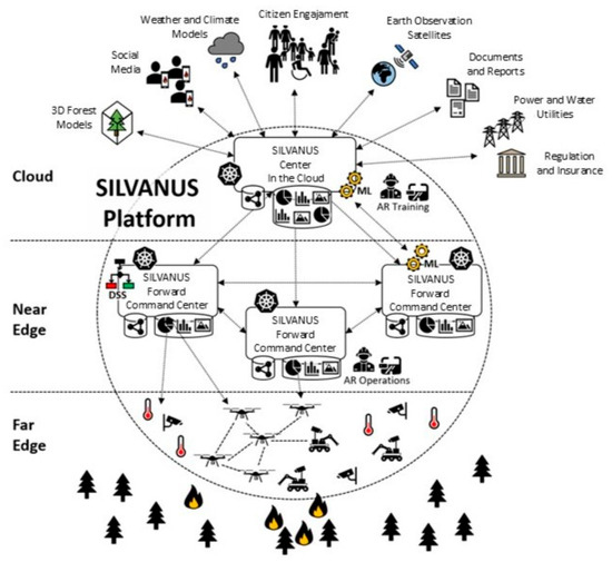
Figure 1.
SILVANUS platform architecture [84].
The project’s activities are structured into three main phases: prevention and preparedness, detection and response, and restoration and adaptation. During the prevention phase, SILVANUS employs advanced detection systems, including IoT devices, drones, and multispectral imaging, to identify high-risk areas before the occurrence of fires. The detection phase enables the rapid mobilization of firefighting resources by providing real-time data on fire locations and behaviors. Finally, the restoration phase prioritizes ecosystem recovery through data-driven strategies that emphasize reforestation efforts in severely affected areas.
Community engagement represents a cornerstone of the SILVANUS approach. The project promotes public safety through educational campaigns that raise awareness about wildfire risks and prevention measures. It also empowers citizens through mobile applications that allow them to report fires or receive alerts about nearby incidents. This participatory approach ensures that wildfire management strategies are inclusive and sustainable while fostering collaboration between local communities and authorities.
The effectiveness of the SILVANUS platform was validated through 11 pilot demonstrations conducted across Europe, Brazil, Indonesia, and Australia. These pilots tested the platform’s capabilities in diverse environmental conditions and fire-prone regions. By combining advanced technologies with interdisciplinary expertise, SILVANUS offers a comprehensive solution to one of the most pressing challenges posed by climate change: wildfire management.
As wildfires continue to threaten ecosystems worldwide, projects such as SILVANUS are providing a vital framework for safeguarding forests while promoting sustainable environmental practices. These approaches not only enhance preparedness and response capabilities, but also support ecological resilience through restoration efforts.
9. Technical Limitations of ML in Sustainable Forest Management
The integration of machine learning (ML) into sustainable forest management (SFM) brings significant promise, but it is accompanied by a range of technical limitations, implementation hurdles, and ethical concerns that must be carefully considered to ensure responsible and effective deployment.
One of the primary technical limitations is the high computational cost associated with processing and analyzing large volumes of data, such as high-resolution satellite imagery and extensive time-series records. Deep learning models, including convolutional neural networks (CNNs) and long short-term memory networks (LSTMs), require substantial GPU or TPU resources, making training and deployment energy-intensive and often cost-prohibitive, especially for institutions with limited budgets. Additionally, advanced architectures like transformers or generative adversarial networks (GANs) used for spatial data synthesis can further escalate computational demands [85,86].
Data quality and availability also pose significant challenges. Ground-truth data, such as biomass plots and tree species labels, are typically sparse, unevenly distributed, and expensive to collect [87]. Remote sensing data, while abundant, may suffer from issues like cloud cover, seasonal biases, or mismatched spatial resolutions, all of which can compromise model accuracy and reliability [88]. Furthermore, many ML models provide only point estimates without inherent uncertainty quantification, making it difficult to inform risk-averse forestry policies or disaster response strategies. While probabilistic approaches, such as Bayesian deep learning or ensemble methods, can address this gap, they often come with increased computational overhead [88].
Model interpretability remains another critical concern. Complex models, particularly deep CNNs and transformers, often function as “black boxes,” making it challenging for forest managers and policymakers to understand and trust the rationale behind predictions. Transparent and explainable models are essential for supporting informed decision-making in SFM [85]. Temporal generalization is also problematic, as models trained on historical data may not adapt well to changing environmental baselines driven by climate change or land-use shifts, leading to reduced reliability over long-term planning horizons. Additionally, the scalability and transferability of models are limited; those trained in one region may not generalize effectively to other forest ecosystems due to ecological heterogeneity, and although transfer learning offers some solutions, underlying ecological biases persist [86].
Beyond technical limitations, several implementation hurdles hinder the widespread adoption of ML in forestry. Many forestry departments, particularly in developing regions, lack the necessary technical capacity, AI expertise, and computational infrastructure. The integration of ML models with existing geographic information systems (GIS) and legacy workflows can be complex, as these systems are often not designed to accommodate advanced analytics [85,86]. Data governance issues, including fragmented or proprietary datasets from satellites, field sensors, and LiDAR, further complicate the creation of unified ML pipelines. The absence of standardized, labeled, and openly accessible benchmark datasets also impedes reproducibility and the objective comparison of models across studies [85,86].
Ethical concerns are equally pressing in the application of ML to SFM. Algorithmic bias can arise when models are trained on datasets that disproportionately represent accessible or well-studied regions, potentially overlooking indigenous lands or marginalized communities. The increasing reliance on automated ML systems may also risk devaluing or disregarding traditional ecological knowledge, which is often crucial for effective forest management. The use of drones and high-resolution satellite data raises legitimate privacy concerns, particularly regarding surveillance over indigenous territories or private lands. Moreover, opaque, black-box decision making—such as automated deforestation alerts or carbon offset valuations—without clear justification can undermine trust and negatively impact local stakeholders. Finally, the environmental cost of computation itself cannot be ignored, as the energy required to train large models may contradict the very sustainability goals that SFM seeks to achieve [85,86].
To address these challenges, several mitigation strategies are recommended. Employing interpretable models, such as random forests combined with SHAP (Shapley Additive Explanations) analysis, and adopting probabilistic approaches like Bayesian neural networks can enhance transparency and uncertainty quantification. Promoting open access forest datasets with robust metadata standards supports data quality and reproducibility [85,86]. Investing in capacity building, particularly in biodiversity-rich but resource-limited regions, is essential to bridge technical gaps and foster local expertise. Finally, adopting an ethics-by-design approach—actively engaging local communities in model development and ensuring algorithmic transparency—can help align technological innovation with the core values and goals of sustainable forest management.
10. Conclusions
Machine learning has proven to be a powerful tool in sustainable forest management, offering innovative solutions for challenges such as deforestation, wildfire management, reforestation, and biodiversity conservation. By processing vast datasets, generating predictive insights, and enabling data-driven decision making, ML approaches have revolutionized how forests are monitored, restored, and protected. Related applications extend beyond forestry into broader climate change mitigation and adaptation efforts, optimizing carbon sequestration, predicting extreme weather events, and guiding infrastructure resilience. These advancements underscore the versatility of ML in addressing interconnected environmental issues.
Despite its immense potential, the adoption of ML in forestry is hindered by challenges such as data availability, model interpretability, and ethical considerations surrounding surveillance technologies. Addressing these barriers requires interdisciplinary collaboration among ecologists, data scientists, policymakers, and local communities. Looking ahead, we expect advancements in satellite technology, IoT devices, and explainable AI to enhance real-time monitoring capabilities and foster trust in ML-driven solutions. By combining technological innovation with ecological expertise and community engagement, ML can play a pivotal role in preserving forests, combating climate change, and ensuring a sustainable future for generations to come.
The main conclusion regarding the application of machine learning (ML) methods in sustainable forest management is that, while ML offers significant potential to enhance forest monitoring, decision making, and conservation efforts, its effectiveness hinges on addressing challenges related to data quality, interpretability, and ethical considerations.
While ML presents opportunities for sustainable forest management, its success depends on overcoming technical, ethical, and social challenges. A collaborative approach that integrates technological innovation with local knowledge and ethical considerations is essential for realizing the full potential of ML in forest conservation.
Funding
This research received no external funding.
Conflicts of Interest
The authors declare no conflict of interest.
References
- Pan, S.J.; Yang, Q. A survey on transfer learning. IEEE Trans. Knowl. Data Eng. 2010, 22, 1345–1359. [Google Scholar] [CrossRef]
- Barto, A.G. Chapter 2—Reinforcement learning. In Neural Systems for Control; Omidvar, O., Elliott, D.L., Eds.; Academic Press: Cambridge, MA, USA, 1997. [Google Scholar] [CrossRef]
- Mienye, D.; Sun, Y. A survey of ensemble learning: Concepts, algorithms, applications, and prospects. IEEE Access 2022, 10, 99129–99149. [Google Scholar] [CrossRef]
- Wistuba, M.; Rawat, A.; Pedapati, T. A survey on neural architecture search. arXiv 2019, arXiv:1905.01392. [Google Scholar] [CrossRef]
- Rani, V.; Nabi, S.T.; Kumar, M.; Mittal, A.; Kumar, K. Self-supervised learning: A succinct review. Arch. Comput. Methods Eng. 2023, 30, 2761–2775. [Google Scholar] [CrossRef] [PubMed]
- Sadeghi, Z.; Alizadehsani, R.; Cifci, M.A.; Kausar, S.; Rehman, R.; Mahanta, P.; Bora, P.K.; Almasri, A.; Alkhawaldeh, R.S.; Hussain, S.; et al. A review of explainable artificial intelligence in healthcare. Comput. Electr. Eng. 2024, 118 Pt A, 109370. [Google Scholar] [CrossRef]
- Truong, A.; Walters, A.; Goodsitt, J.; Hines, K.; Bruss, C.B.; Farivar, R. Towards automated machine learning: Evaluation and comparison of AutoML approaches and tools. In Proceedings of the 31st IEEE International Conference on Tools with Artificial Intelligence, ICTAI 2019, Portland, OR, USA, 4–6 November 2019; pp. 1471–1479. [Google Scholar] [CrossRef]
- Mammen, P.M. Federated learning: Opportunities and challenges. arXiv 2021, arXiv:2101.05428. [Google Scholar] [CrossRef]
- Ece, A.; Abdurrahim, A. Machine learning-based prediction of insect damage spread using an auto-ARIMA model. Croat. J. For. Eng. 2024, 45, 13. [Google Scholar] [CrossRef]
- Chu, S.; Bao, W. Improving the accuracy of pine wilt disease detection through the integration of multispectral imaging and machine learning. In Proceedings of the 3rd International Conference on Image Processing and Media Computing (ICIPMC), Hefei, China, 17–19 May 2024; pp. 299–304. [Google Scholar] [CrossRef]
- Dahan, K.S.; Kasei, R.A.; Husseini, R.; Sarr, M.; Said, M.Y. Analysis of the future potential impact of environmental and climate changes on wildfire spread in Ghana’s ecological zones using a Random Forest (RF) machine learning approach. Remote Sens. Appl. Soc. Environ. 2024, 33, 101091. [Google Scholar] [CrossRef]
- Lillesand, T.; Kiefer, R.W.; Chipman, J. Remote Sensing and Image Interpretation; John Wiley & Sons: Hoboken, NJ, USA, 2015. [Google Scholar]
- Camps-Valls, G.; Tuia, D.; Zhu, X.X.; Reichstein, M. (Eds.) Deep Learning for the Earth Sciences: A Comprehensive Approach to Remote Sensing, Climate Science and Geosciences; John Wiley & Sons: Hoboken, NJ, USA, 2021. [Google Scholar] [CrossRef]
- Zhu, X.X.; Tuia, D.; Mou, L.; Xia, G.S.; Zhang, L.; Xu, F.; Fraundorfer, F. Deep learning in remote sensing: A comprehensive review and list of resources. IEEE Geosci. Remote Sens. Mag. 2017, 5, 8–36. [Google Scholar] [CrossRef]
- Hasan, R.; Farabi, S.F.; Kamruzzaman, M.; Bhuyan, M.K.; Nilima, S.I.; Shahana, A. AI-driven strategies for reducing deforestation. Am. J. Eng. Technol. 2024, 6, 6–20. [Google Scholar] [CrossRef]
- Dalagnol, R. Mapping tropical forest degradation with deep learning and Planet NICFI data. Remote Sens. Environ. 2023, 298, 113798. [Google Scholar] [CrossRef]
- Felix, F.C.; Kratz, D.; Ribeiro, R.; Nogueira, A.C. Machine learning in the identification of native species from seed image analysis. J. Seed Sci. 2024, 46, e202446002. [Google Scholar] [CrossRef]
- Hill, A.P.; Prince, P.; Covarrubias, E.P.; Doncaster, C.P.; Snaddon, J.L.; Rogers, A. AudioMoth: Evaluation of a smart open acoustic device for monitoring biodiversity and the environment. Methods Ecol. Evol. 2018, 9, 1199–1211. [Google Scholar] [CrossRef]
- Wan, L.; Zhou, W.; He, Y.; Wanger, T.C.; Cen, H. Combining transfer learning and hyperspectral reflectance analysis to assess leaf nitrogen concentration across different plant species datasets. Remote Sens. Environ. 2022, 269, 112826. [Google Scholar] [CrossRef]
- Weinstein, B.G.; Graves, S.J.; Marconi, S.; Singh, A.; Zare, A.; Stewart, D.; Bohlman, S.A.; White, E.P. A benchmark dataset for canopy crown detection and delineation in co-registered airborne RGB, LiDAR and hyperspectral imagery from the National Ecological Observation Network. PLOS Comput. Biol. 2021, 17, e1009180. [Google Scholar] [CrossRef]
- Li, X.; Wang, A. Forest pest monitoring and early warning using UAV remote sensing and computer vision techniques. Sci. Rep. 2025, 15, 401. [Google Scholar] [CrossRef] [PubMed]
- Michael, Y.; Helman, D.; Glickman, O.; Gabay, D.; Brenner, S.; Lensky, I.M. Forecasting fire risk with machine learning and dynamic information derived from satellite vegetation index time-series. Sci. Total Environ. 2021, 764, 142844. [Google Scholar] [CrossRef]
- Ouaknine, A.; Kattenborn, T.; Laliberté, E.; Rolnick, D. OpenForest: A data catalogue for machine learning in forest monitoring. arXiv 2023, arXiv:2311.00277. [Google Scholar] [CrossRef]
- Fenza, G.; Gallo, M.; Loia, V.; Gaeta, M.; Herrera-Viedma, E. Data set quality in machine learning: Consistency measure based on group decision making. Appl. Soft Comput. 2021, 106, 107366. [Google Scholar] [CrossRef]
- Singha, C. Integrating geospatial, remote sensing, and machine learning for climate-induced forest fire susceptibility mapping in Similipal Tiger Reserve, India. For. Ecol. Manag. 2024, 555, 121729. [Google Scholar] [CrossRef]
- Macarringue, L.S.; Bolfe, É.L.; Pereira, P.R.M. Developments in land use and land cover classification: Advances achieved, challenges, and future perspectives. J. Geogr. Inf. Syst. 2022, 14, 1–28. [Google Scholar] [CrossRef]
- Rubí, J.N.S.; Gondim, P.R.L. A performance comparison of machine learning models for wildfire occurrence risk prediction in the Brazilian Federal District region. Environ. Syst. Decis. 2024, 44, 351–368. [Google Scholar] [CrossRef]
- Jackson, C.M.; Adam, E. A machine learning approach to mapping canopy gaps in an indigenous tropical submontane forest using WorldView-3 multispectral satellite imagery. Environ. Conserv. 2022, 49, 255–262. [Google Scholar] [CrossRef]
- Dalagnol, R.; Phillips, O.L.; Gloor, E.; Galvão, L.S.; Wagner, F.H.; Locks, C.J.; Aragão, L.E.O.C. Quantifying canopy tree loss and gap recovery in tropical forests under low-intensity logging using VHR satellite imagery and airborne LiDAR. Remote Sens. 2019, 11, 817. [Google Scholar] [CrossRef]
- Matosak, B.M.; Fonseca, L.M.G.; Taquary, E.C.; Maretto, R.V.; Bendini, H. do N.; Adami, M. Mapping deforestation in Cerrado based on hybrid deep learning architecture and medium spatial resolution satellite time series. Remote Sens. 2022, 14, 209. [Google Scholar] [CrossRef]
- Torres, D.L.; Turnes, J.N.; Vega, P.J.S.; Feitosa, R.Q.; Silva, D.E.; Junior, J.M.; Almeida, C. Deforestation detection with fully convolutional networks in the Amazon Forest from Landsat-8 and Sentinel-2 images. Remote Sens. 2021, 13, 5084. [Google Scholar] [CrossRef]
- Li, X. Detection of shoreline erosion using satellite image and machine learning. In Proceedings of the 3rd International Conference on Big Data, Artificial Intelligence and Internet of Things Engineering (ICBAIE), Xi′an, China, 15–17 July 2022; pp. 776–780. [Google Scholar] [CrossRef]
- Yang, J.; Jiang, H.; Wang, S.; Ma, X. A multi-scale deep learning algorithm for enhanced forest fire danger prediction using remote sensing images. Forests 2023, 15, 1581. [Google Scholar] [CrossRef]
- Jonnalagadda, A.V.; Hashim, H.A. SegNet: A segmented deep learning based convolutional neural network approach for drones wildfire detection. Remote Sens. Appl. Soc. Environ. 2024, 34, 101181. [Google Scholar] [CrossRef]
- Üstek, İ.; Arana-Catania, M.; Farr, A.; Petrunin, I. Deep autoencoders for unsupervised anomaly detection in wildfire prediction. arXiv 2024, arXiv:2411.09844. [Google Scholar] [CrossRef]
- Mistick, K.A.; Campbell, M.J.; Dennison, P.E. Visibility-informed mapping of potential firefighter lookout locations using maximum entropy modelling. Int. J. Wildland Fire 2024, 33, WF24065. [Google Scholar] [CrossRef]
- Sun, X.; Li, N.; Chen, D.; Chen, G.; Sun, C.; Shi, M.; Gao, X.; Wang, K.; Hezam, I.M. A forest fire prediction model based on cellular automata and machine learning. IEEE Access 2024, 12, 55389–55403. [Google Scholar] [CrossRef]
- Pinto, M.M.; Libonati, R.; Trigo, R.M.; Trigo, I.F.; DaCamara, C.C. A deep learning approach for mapping and dating burned areas using temporal sequences of satellite images. ISPRS J. Photogramm. Remote Sens. 2020, 160, 260–274. [Google Scholar] [CrossRef]
- Karimi, S.; Heidari, M.; Mosavi, A. Machine learning for modeling vegetation restoration of forests using satellite images. In Proceedings of the IEEE 22nd World Symposium on Applied Machine Intelligence and Informatics (SAMI), Stará Lesná, Slovakia, 14 February 2024; pp. 531–538. [Google Scholar] [CrossRef]
- Shalan, A.; Tarmissi, K.; Walee, N.A. Vulnerability analysis and quality improvement of early wildfire detection datasets for machine-learning applications. In Proceedings of the IEEE 13th International Conference on Communication Systems and Network Technologies (CSNT), Jabalpur, India, 6–7 April 2024; pp. 754–760. [Google Scholar] [CrossRef]
- Khan, M.A.; Park, H. FireXplainNet: Optimizing convolution block architecture for enhanced wildfire detection and interpretability. Electronics 2024, 13, 1881. [Google Scholar] [CrossRef]
- Khallaf, A.N.; Alqerafi, N.M. Using AI to help reduce the effect of global warming. Power Syst. Technol. 2024, 48, 1927–1947. [Google Scholar] [CrossRef]
- Bot, K.; Borges, J.G. A systematic review of applications of machine learning techniques for wildfire management decision support. Inventions 2022, 7, 15. [Google Scholar] [CrossRef]
- Sathishkumar, V.E.; Cho, J.; Subramanian, M.; Naren, O.S. Forest fire and smoke detection using deep learning-based learning without forgetting. Fire Ecol. 2023, 19, 9. [Google Scholar] [CrossRef]
- Abid, F. A survey of machine learning algorithms based forest fires prediction and detection systems. Fire Technol. 2021, 57, 559–590. [Google Scholar] [CrossRef]
- Hopkins, J.; Santos-Elizondo, G.M.; Villablanca, F. Detecting and monitoring rodents using camera traps and machine learning versus live trapping for occupancy modeling. Front. Ecol. Evol. 2024, 12, 1359201. [Google Scholar] [CrossRef]
- Wu, J.; Huang, K.; Luo, Y.; Long, X.; Yu, C.; Xiong, H.; Du, J. Identification of dominant species and their distributions on an uninhabited island based on unmanned aerial vehicles (UAVs) and machine learning models. Remote Sens. 2024, 16, 1652. [Google Scholar] [CrossRef]
- Yudaputra, A.; Yuswandi, A.Y.; Witono, J.R.; Cropper, W.P.; Usmadi, D. Tree species identification in ex situ conservation areas using WorldView-2 satellite data and machine learning methods: A case study in the Bogor Botanic Garden. Trop. Ecol. 2024, 65, 81–91. [Google Scholar] [CrossRef]
- Das, P.; Rahimzadeh-Bajgiran, P.; Livingston, W.; McIntire, C.D.; Bergdahl, A. Modeling forest canopy structure and developing a stand health index using satellite remote sensing. Ecol. Inform. 2024, 84, 102864. [Google Scholar] [CrossRef]
- Yebeyen, D.; Hailu, B.T.; Zewdie, W.; Abera, T.; Sileshi, G.W.; Getachew, M.; Nemomissa, S. Improved mapping of highland bamboo forests using Sentinel-2 time series and machine learning in Google Earth Engine. Geocarto Int. 2024, 39, 2364680. [Google Scholar] [CrossRef]
- Mondal, I.; Naskar, P.K.; Alsulamy, S.; Jose, F.; Hossain, S.A.; Mohammad, L.; De, T.K.; Khedher, K.M.; Salem, M.A.; Benzougagh, B.; et al. Habitat quality and degradation change analysis for the Sundarbans mangrove forest using invest habitat quality model and machine learning. Environ. Dev. Sustain. 2024, 1–26. [Google Scholar] [CrossRef]
- Sangeetha, R.G. Unmanned aerial surveillance and tracking system in forest areas for poachers and wildlife. IEEE Access 2024, 12, 187572–187586. [Google Scholar] [CrossRef]
- Fergus, P.; Chalmers, C.; Longmore, S.; Wich, S. Harnessing artificial intelligence for wildlife conservation. Conservation 2024, 4, 685–702. [Google Scholar] [CrossRef]
- Singh, V.; Ray, K.C.; Tripathy, S. Real-time monitoring of illegal logging events using intelligent acoustic sensor nodes. IEEE Sens. J. 2024, 24, 28276–28286. [Google Scholar] [CrossRef]
- Sachi, S.; Kumar, S. Integrating computational methods in pure and applied zoology: Enhancing species conservation and behavioral studies. Biochem. Cell. Arch. 2024, 24, 2209. [Google Scholar] [CrossRef]
- Day, C.C.; Landguth, E.L.; Sawaya, M.A.; Clevenger, A.P.; Long, R.A.; Holden, Z.A.; Akins, J.R.; Anderson, R.B.; Aubry, K.B.; Barrueto, M.; et al. Genetic connectivity of wolverines in western North America. Sci. Rep. 2024, 14, 28248. [Google Scholar] [CrossRef]
- Sankar, R.; Mantha, K.; Nesmith, C.; Fortson, L.; Brueshaber, S.; Hansen-Koharcheck, C.; Orton, G. Understanding confusion: A case study of training a machine model to predict and interpret consensus from volunteer labels. Citiz. Sci. Theory Pract. 2024, 9, 41. [Google Scholar] [CrossRef]
- Mora, K.; Rzanny, M.; Wäldchen, J.; Feilhauer, H.; Kattenborn, T.; Kraemer, G.; Mäder, P.; Svidzinska, D.; Wolf, S.; Mahecha, M.D. Macrophenological dynamics from citizen science plant occurrence data. Methods Ecol. Evol. 2024, 15, 1422–1437. [Google Scholar] [CrossRef]
- Khan, F.H.; de Silva, A.; Dusek, G.; Davis, J.; Pang, A. SmartCS: Enabling the creation of ML-powered computer vision mobile apps for citizen science applications without coding. arXiv 2024, arXiv:2405.14323. [Google Scholar] [CrossRef]
- O’Malley, W.C.; Elbroch, L.M.; Zeller, K.A.; Beier, P.; Beale, M.M.; Beausoleil, R.A.; Kertson, B.; Knopff, K.; Kunkel, K.; Maletzke, B.T.; et al. Machine learning allows for large-scale habitat prediction of a wide-ranging carnivore across diverse ecoregions. Landsc. Ecol. 2024, 39, 106. [Google Scholar] [CrossRef]
- Refaat, A.M.; Youssef, A.M.; Mosallam, H.A.-A.; Farouk, H. Predicting the effect of climate change on the spatiotemporal distribution of two endangered plant species, Silene leucophylla Boiss. and Silene schimperiana Boiss., using machine learning, in Saint Catherine Protected Area. Beni-Suef Univ. J. Basic Appl. Sci. 2024, 13, 98. [Google Scholar] [CrossRef]
- Fernandes, A.C.M.; Gonzalez, R.Q.; Lenihan-Clarke, M.A.; Trotter, E.F.L.; Arsanjani, J.J. Machine learning for conservation planning in a changing climate. Sustainability 2020, 12, 7657. [Google Scholar] [CrossRef]
- Tuia, D.; Kellenberger, B.; Beery, S.; Costelloe, B.R.; Zuffi, S.; Risse, B.; Mathis, A.; Mathis, M.W.; van Langevelde, F.; Burghardt, T.; et al. Perspectives in machine learning for wildlife conservation. Nat. Commun. 2022, 13, 792. [Google Scholar] [CrossRef] [PubMed]
- Barta, Z. Deep learning in terrestrial conservation biology. Biol. Futur. 2023, 74, 359–367. [Google Scholar] [CrossRef]
- Dantas, D.; Terra, M.C.N.S.; Schorr, L.P.B.; Calegario, N. Machine learning for carbon stock prediction in a tropical forest in Southeastern Brazil. Bosque 2021, 42, 131–140. [Google Scholar] [CrossRef]
- Pikkarainen, L.; Strandman, H.; Vento, E.; Petty, A.; Tikkanen, O.-P.; Kilpeläinen, A.; Peltola, H. Effects of forest conservation and management on timber, ecosystem carbon, dead wood and habitat suitability area in a boreal forest under climate change. Silva Fenn. 2024, 58, 23045. [Google Scholar] [CrossRef]
- Chandrakala, D.; Ranganathan, C.S.; Swarnalatha, E.; Karpagalakshmi, R.C.; Meenakshi, B.; Srinivasan, S. Enhancing data security in cloud-based soil carbon sequestration monitoring systems using random forest regression. In Proceedings of the International Conference on Intelligent Systems for Cybersecurity (ISCS), Gurugram, India, 3–4 May 2024; pp. 1–6. [Google Scholar] [CrossRef]
- Altarazi, F. Optimizing waste reduction in manufacturing processes utilizing IoT data with machine learning approach for sustainable production. Scalable Comput. Pract. Exp. 2024, 25, 4192–4204. [Google Scholar] [CrossRef]
- Iglesias, J.; Cuesta, I.; Salueña, C.; Solé, J.; Prevatt, D.O.; Fabregat, A. Predictive modeling of severe weather impact on individuals and populations using machine learning. Int. J. Disaster Risk Reduct. 2024, 105, 104398. [Google Scholar] [CrossRef]
- Abed, W.; Coppola, E. Detection of high convective precipitation events using machine learning methods. In Proceedings of the EGU General Assembly, Vienna, Austria, 14–19 April 2024. EGU24-21760. [Google Scholar] [CrossRef]
- Nyango, J. Climate-proofing critical energy infrastructure: Smart grids, artificial intelligence, and machine learning for power system resilience against extreme weather events. J. Infrastruct. Syst. 2024, 30, 03124001. [Google Scholar] [CrossRef]
- Tabasinezhad, N.; Mousavi-Sabet, H.; Mostafavi, H. Forecasting habitat changes of Vimba persa (Pallas, 1814) under climate change using machine learning techniques in the southern Caspian Sea basin. Int. J. Aquat. Biol. 2024, 12, 109–119. [Google Scholar] [CrossRef]
- Fisher, J.; Allen, S.; Yetman, G.; Pistolesi, L. Assessing the influence of landscape conservation and protected areas on social wellbeing using random forest machine learning. Sci. Rep. 2024, 14, 11357. [Google Scholar] [CrossRef]
- Zheng, J. Deciphering the climate-malaria nexus: A machine learning approach in rural southeastern Tanzania. Public Health 2025, 238, 124–130. [Google Scholar] [CrossRef] [PubMed]
- Sebastianelli, A.; Spiller, D.; Carmo, R.; Wheeler, J.; Nowakowski, A.; Jacobson, L.V.; Kim, D.; Barlevi, H.; Cordero, Z.E.R.; Colón-González, F.J.; et al. A reproducible ensemble machine learning approach to forecast dengue outbreaks. Sci. Rep. 2024, 14, 3807. [Google Scholar] [CrossRef]
- Nguyen, K.A.; Seeboonruang, U.; Chen, W. Projected climate change effects on global vegetation growth: A machine learning approach. Environments 2023, 10, 204. [Google Scholar] [CrossRef]
- Drummond, J. The garden in the machine: An environmental history of Brazil’s Tijuca Forest. Environ. Hist. 1996, 1, 83–104. [Google Scholar] [CrossRef]
- Freitas, S.R.; Neves, C.L.; Chernicharo, P. Tijuca National Park: Two pioneering restorationist initiatives in Atlantic tropical forest in southeastern Brazil. Braz. J. Biol. 2006, 66, 975–982. [Google Scholar] [CrossRef] [PubMed]
- Suman, D.O.; Morais, M.; Saito, C.H. Solutions based on nature to face water stress: Lessons from the past and present. Water 2024, 16, 2301. [Google Scholar] [CrossRef]
- Bondur, V.; Chimitdorzhiev, T.; Kirbizhekova, I.; Dmitriev, A. A novel method of boreal zone reforestation/afforestation estimation using PALSAR-1,2 and Landsat-5,8 data. Forests 2024, 15, 132. [Google Scholar] [CrossRef]
- Francini, S.; Cavalli, A.; D’Amico, G.; McRoberts, R.E.; Maesano, M.; Munafò, M.; Mugnozza, G.S.; Chirici, G. Reusing remote sensing-based validation data: Comparing direct and indirect approaches for afforestation monitoring. Remote Sens. 2023, 15, 1638. [Google Scholar] [CrossRef]
- Faisal, A.; Mumtaz, R.; Mazhar, M.D.; Tahir, M.A.; Jhanjhi, N.Z.; Masud, M.; Shorfuzzaman, M. Data-driven spatial analysis of reforestation in Pakistan: Identifying optimal locations for sustainable forest growth and climate change mitigation. IEEE Access 2024, 12, 190375–190388. [Google Scholar] [CrossRef]
- Sakti, A.D.; Komara, H.Y.; Sumarga, E.; Choiruddin, A.; Hendrawan, V.S.A.; Hati, T.; Anna, Z.; Wikantika, K. Optimizing afforestation and reforestation strategies to enhance ecosystem services in critically degraded regions. Trees For. People 2024, 18, 100700. [Google Scholar] [CrossRef]
- Silvanus Project. Our Approach. Available online: https://silvanus-project.eu/about/approach/ (accessed on 10 April 2025).
- Nunes, L.J.R. The Role of Artificial Intelligence (AI) in the Future of Forestry Sector Logistics. Future Transp. 2025, 5, 63. [Google Scholar] [CrossRef]
- Wang, T.; Zuo, Y.; Manda, T.; Hwarari, D.; Yang, L. Harnessing Artificial Intelligence, Machine Learning and Deep Learning for Sustainable Forestry Management and Conservation: Transformative Potential and Future Perspectives. Plants 2025, 14, 998. [Google Scholar] [CrossRef]
- Zhao, J.; Wang, J.; Anderson, N. Machine learning applications in forest and biomass supply chain management: A review. Int. J. For. Eng. 2024, 35, 371–380. [Google Scholar] [CrossRef]
- Jain, M.; Pandey, V.; Chhuttani, P.; Sandeep, C. AI-driven forest management: A critical study. In National Seminar on Enhancing Privacy Protection in the Digital Age: Legal Challenges & Innovations (NSEPPDA 2025), Gurugram, India, 24–25 January 2025; Atlantis Press: Dordrecht, The Netherlands, 2025; pp. 273–297. [Google Scholar] [CrossRef]
Disclaimer/Publisher’s Note: The statements, opinions and data contained in all publications are solely those of the individual author(s) and contributor(s) and not of MDPI and/or the editor(s). MDPI and/or the editor(s) disclaim responsibility for any injury to people or property resulting from any ideas, methods, instructions or products referred to in the content. |
© 2025 by the authors. Licensee MDPI, Basel, Switzerland. This article is an open access article distributed under the terms and conditions of the Creative Commons Attribution (CC BY) license (https://creativecommons.org/licenses/by/4.0/).