Article

Unraveling the Intricate Links between the Dwindling Aral Sea and Climate Variability during 2002–2017

by
Timur Berdimbetov
1,
Buddhi Pushpawela
2,*,
Nikita Murzintcev
1,
Sahibjamal Nietullaeva
1,
Khusen Gafforov
3,
Asiya Tureniyazova
1 and
Dauranbek Madetov
1
1
Nukus Branch of Tashkent University of Information Technologies named after Muhammad al-Khwarizmi, Nukus 130100, Uzbekistan
2
The Department of Physics and Astronomy, The University of Alabama in Huntsville, Huntsville, AL 35899, USA
3
Scientific Research Institute of Irrigation and Water Problems, Tashkent 100000, Uzbekistan
*
Author to whom correspondence should be addressed.
Climate 2024, 12(7), 105; https://doi.org/10.3390/cli12070105
Submission received: 14 May 2024 / Revised: 1 July 2024 / Accepted: 8 July 2024 / Published: 18 July 2024

Abstract

:
The Aral Sea is an indispensable component of the socio-economic progress of Central Asia but has undergone substantial ecological transformations over the last few decades, primarily due to global warming and human activities. Among these changes, the basin area has decreased, and water levels have dropped. This paper focuses on a comprehensive analysis of the spatial variation of key climate parameters, such as temperature, precipitation, and potential evapotranspiration over the Aral Sea. Moreover, we examined the transformation of seasonal water areas in the Aral Sea during the growing and non-growing seasons between 2002 and 2017 and the influence of climate and human factors on these changes using Landsat satellite data. Our results indicate that the western section of the Aral Sea has experienced a reduction in water area by 2.41 km2 and 1.83 km2 during the warm (R2 = 0.789) and cold (R2 = 0.744) seasons, respectively, over the investigated period. The decrease in lake water volume during the warm season can be attributed to local climate variations, as a strong negative correlation exists between seasonal water storage change and temperature (potential evapotranspiration). The correlation analysis shows that the water change in the northern part of the Aral Sea during the growing season has a significant positive correlation with temperature (R = 0.52) and an insignificant negative correlation with precipitation (R = −0.22). On the contrary, in the west and east parts of the Aral Sea, there is a significant negative correlation with temperature (R = −0.71 and −0.62) and a high positive correlation with precipitation (R = 0.71 and 0.55) during the growing season.

1. Introduction

Global warming has been causing fluctuations in precipitation distribution patterns, moisture budget, and the hydrological cycle. Central Asia is one of the most vulnerable regions prone to drought, dry land, and water stress [1,2,3]. The Intergovernmental Panel on Climate Change (IPCC) has highlighted an increased risk of drought-related water and food shortages in the coming decades in the land-locked areas of the world [4,5]. Earlier studies have identified changes in climatic parameters, such as air temperature, the reason for the length of the growing season, decreased relative humidity, and severe dryness [6,7,8]. Another study that discussed the driving force behind climate warming has highlighted the rising levels of annual mean temperatures and temperature extremes, mainly in Central Asia [9].
Irrigation-dominated agricultural production in Central Asia includes wheat, rice, and cotton [10]. Due to intense irrigation practices, the groundwater level drops quickly every spring, causing salinization of the soil in the region [11,12]. The location of urban areas can highlight the information about water use rates. In recent decades, remote sensing techniques have attracted increasing interest, and their applications have been used extensively for monitoring hydro-climatic processes at the global, regional, and national scales. The Gravity Recovery and Climate Experiment (GRACE) dual satellites, which orbited Earth from 2002 to 2017, were jointly launched by the National Aeronautics and Space Administration (NASA) and the German Aerospace Center (DLR) in March 2002 and made detailed measurements of Earth’s gravity field and improved investigations about Earth’s water reservoirs over land, ice, and oceans [13,14]. The GRACE data were also used to identify extreme weather conditions, such as droughts and floods. The GRACE-derived terrestrial water storage (TWS) values provide different types of water storage datasets above and beneath the ground, including soil moisture, snow water equivalent, and water contained in biomass [15]. A variation in TWS directly reflects changes in the hydrological cycle [16].
Reliable climate data about the region are essential for modeling climate change and planning adaptation policies. The Central Asian region lacks a well-established mechanism for systematically collecting climatic data, leading to a dearth of consistent climate-related observations from the existing meteorological stations [2,17]. Several weather stations ceased operation after 1991; for example, of the nine stations that were operational in the Soviet era, only the following three are active now: Aralsk, Moynak, and Aktumsik [18].
In previous studies, several research works were carried out on the change in the water volume of the Aral Sea and its climate and anthropogenic impact. Izhitskiy, A. and G. AyzelIzhitskiy, A. and G. Ayzel [19] emphasized in their work that the water volume of the North Aral Sea, which is a small part of the Aral Sea located in the territory of Kazakhstan, has increased significantly in recent years due to the construction of the Kokaral Dam. When the changes in surface water area in the ASB were studied based on the Google Earth Engine cloud platform, it was estimated that the lake area (34,999.61 km2) is about 10 times more than the reservoir area (3879.08 km2) in the ASB. From 1992 to 2020, the total area of surface water in ASB decreased by 34.58%. The share of lakes and reservoirs in total surface water decreased from 79.33% (during the period 1992–2000) to 75.21% (during the period 2000–2010) to 63.94% (during the period 2010–2020) [20]. Modern Aral Sea water balance studies are mainly based on satellite and indirect data sources. The volume and surface area of the Aral Sea residual basins were estimated using a combined approach of satellite altimetry, digital bathymetry, and MODIS imagery [21]. The total water volume loss for the Aral Sea residual basins was estimated using AVHRR water cover and sea level from altimeter data [22], as well as Gravity Recovery and Climate Experiment satellite observations [23]. In addition, a study was conducted to describe land cover conversion in the Aral Sea basin in the changing climate conditions using an intensity analysis and the transfer matrix method, as well as to determine the anthropogenic impact on the ASB [24].
The number of scientific works analyzing the seasonal changes in the Aral Sea water levels and the impact of the climate on it is limited [25]. Most of the previous studies reported the conditions of lakes in Central Asia separately. This paper presents a comprehensive analysis of the spatial variation of key climate parameters such as temperature, precipitation, and potential evaporation over the Aral Sea and other large lakes in Central Asia, and the impact of these climate parameters on water variability. Therefore, this paper aims to provide a broader analysis of water reservoirs related to the Aral Sea Basin based on a more expanded area of observation.

2. Materials and Methods

2.1. Study Area

In this paper, we investigated the change in seasonal (growing and non-growing) water areas in large lakes in the Aral Sea basin (ASB) region from 2002 to 2017 and the impacts of climate and human factors on it using satellite data (Landsat). We focused on changes in the area of Aral Lake water, as well as Aydar Lake (AL) (see Figure 1c,d) and Sarygamysh Lake (SL) (see Figure 1e,f).
The chosen lakes are succinctly characterized as follows: AL is situated within the confines of Uzbekistan, and its genesis in the 1960s can be attributed to the inundation caused by the Chardara reservoir’s surfeit water [26]. Its primary water source is the Syr Darya River, and the lake is 159 km long and 26 km wide. As of 2005, the volume of AL was 44.3 km3, and the water surface was 3000 km2. SL is located in Turkmenistan and Uzbekistan [27,28]. According to sources in 2000 [29], the lake was 100–120 km long, 30–40 km wide, and 30–40 m deep. According to 1985 data, the water’s surface area was 3200 km2. The volume of SL and water surface depends on the amount of groundwater and runoff from the collector [30]. Previous studies reported that the Aral Sea was divided into smaller water bodies due to the reduction in water volume [31,32]. Currently, the Aral Sea is partitioned into two distinct regions, namely the North Aral Sea (also known as the small Aral Sea in certain literature) and the South Aral Sea (or the large Aral Sea). After the 2000s (officially since 2006), the South Aral Sea was further divided into two parts: the West Aral Sea (WES) and the East Aral Sea (EAS) [33,34]. Figure 1 shows the water changes in the five lakes in 2002 and July 2017 from the Landsat images.

2.2. Datasets

In this paper, we discuss the climate factors we referred to, such as temperature (TMP, monthly), precipitation (PRE, monthly), and potential evapotranspiration (PET, daily) from the CRU TS 4.02 dataset, University of East Anglia https://crudata.uea.ac.uk/cru/data (accessed 10 November 2018). The CRU dataset covers all land areas (except Antarctica) for the period from 1901 to 2017 (at a spatial resolution of 0.5 × 0.5 degrees), and it is constructed based on monthly observational data from land meteorological stations across the world. For spatial analysis, the part of the CRU data belonging to the study area was extracted using a QGIS extract by mask, and interpolation was performed on each grid cell using the interpolation method to interpolate average climate variables for each grid cell in the total area [3]. This interpolation method has been successfully used in past studies to analyze climate change in Central Asia [35,36].
We also used Landsat-7, produced in 1999, which had a malfunction in the ETM+ scanning line in 2003, which resulted in a pixel quality loss of 22% of the collected data [37]. The latest satellite in the Landsat series, the Landsat-8, collects images using nine shortwaves at a 30 m spatial resolution. Landsat-7, produced in 1999, had a malfunction in the ETM+ scanning line in 2003, which resulted in a pixel quality loss of 22% of the collected data [37]. The latest satellite in the Landsat series, the Landsat-8, collects images using nine shortwaves at a 30 m spatial resolution. Both ETM+ sensors (Landsat 7 and 8) provide 16-day, same-resolution images [38]. Landscape imagery allows us to study the seasonal and annual variations of lakes. In this study, Landsat-7 and Landsat-8 images obtained from the United States Geological Survey EarthExplorer database https://earthexplorer.usgs.gov (accessed 13 February 2013) were employed to investigate the temporal variability of water surface area in the Aral Sea and other lakes. Additionally, hydrology data were utilized to examine the changes in runoff.

2.3. Methods

Mapping of lake surface water: The investigation aims to quantify alterations in the water surface area of the chosen lakes. To accomplish this objective, a multi-band approach, specifically the Modified Normalized Difference Water Index (MNDWI), is employed to evaluate the changes in lake water areas. The MNDWI represents an enhanced version of the Normalized Difference Water Index (NDWI) and effectively distinguishes water bodies [39]. Landsat-7 and Landsat-8 (408 images) were used to determine the change in lake water from 2002–2017.
MNDWI = G r e e n M I R / G r e e n + M I R
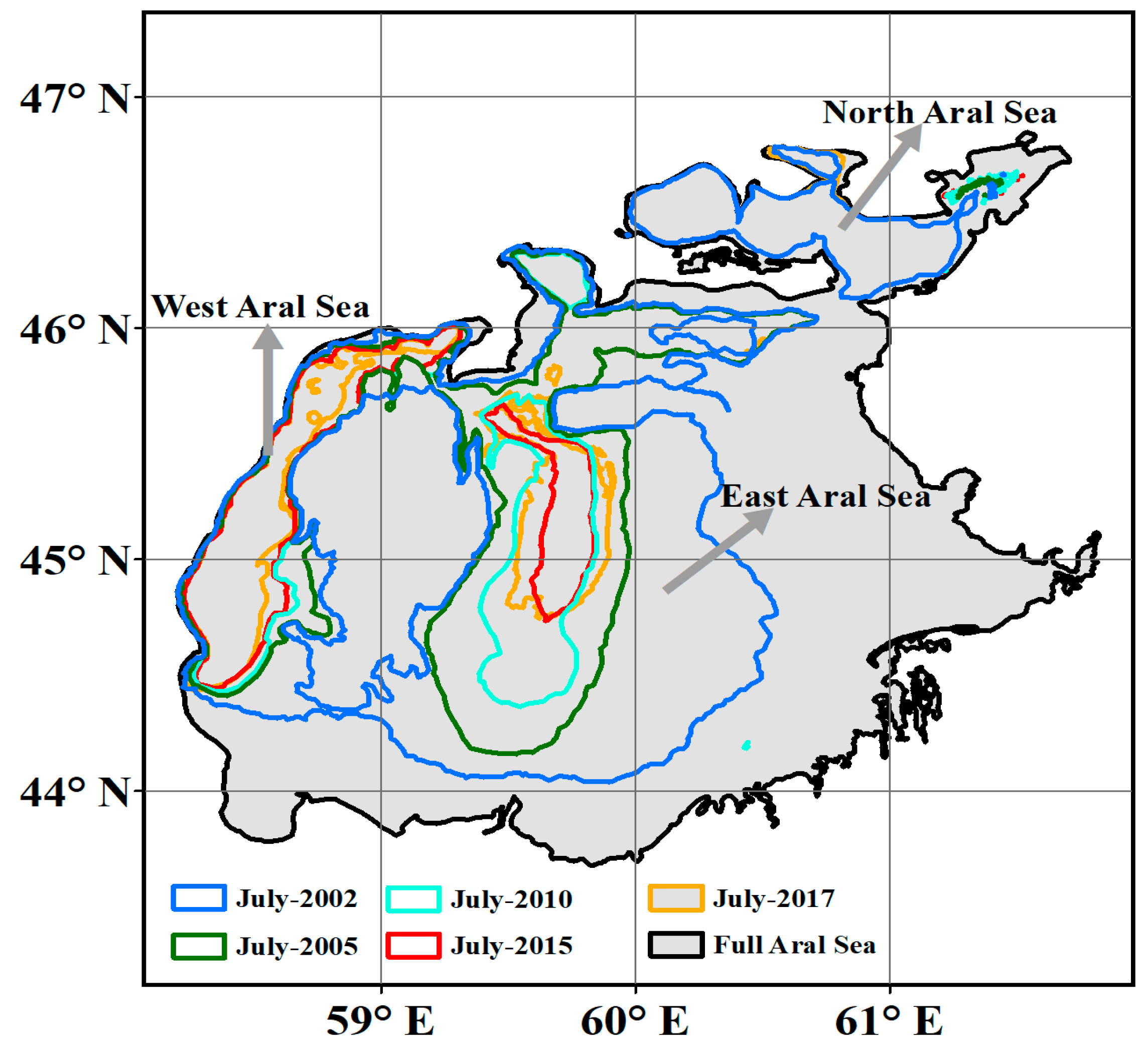
where Green is the green-band value, which corresponds to OLI/TIRS band 3 and ETM+ band 2; and MIR is the middle infrared band value, which corresponds to OLI/TIRS band 6 and ETM+ band 5. From the above formula, MNDWI is divided into two segments, water (zero value: 0) and non-water (negative value: −1); we take zero value as water body [39,40]. The changes in the water area of lakes in the Aral Sea region using Equation (1) are shown in Figure 2 below.
We also used the cross-correlation function to determine the correlation connection and time lags between all lakes’ water change [41].
C k = i A t i k B t i i A t i 2 i B t i 2
where C k is a function dependent on the time shifts k defined in the interval −1 to 1. The function values indicate the degree of linear correlation between two-time series A t and B t .

3. Results

3.1. Spatial Distribution of Climate Parameters

Over the past few decades, global warming and regional desiccation have been acute problems due to their major global effects. These processes are also serious problems in the Aral Sea region. As shown in Figure 3a, in climatology, the mean annual TMP rises from the northern part to the southern part of the sea. The highest temperature in the southeast of the region is 10–11 °C. Over the northern part of the Aral Sea, the mean annual temperature is around 8.2 °C. In the Aral Sea, the mean annual temperature is 9 °C. The spatial distribution of mean annual precipitation (Figure 3b) decreases from the northeast part of the sea to the southwest, with the lowest value (6–8 mm) prevalent in the desert areas around the Aral Sea. The distribution of PET resembles the distribution of temperature, i.e., high PET in areas where high temperatures are observed and vice versa (Figure 3c).
Table 1 presents the average values and the trend in the three main climate parameters (TMP, PRE, PET) observed from 2002 to 2017 for the lakes (NAS, WAS, EAS, SL, and AL). The mean change in these climate parameters on the lakes was analyzed using the shapefile of each lake and spatial CRU data. In the growing season, TMP shows a significantly high positive trend value for NAS, WAS, and EAS, and a low positive trend value for SL and AL. Even in the non-growing season, we can see an increase in TMP values in almost all regions except AL. PRE has an almost negative trend value in all regions and both seasons; only over NAS can we see a low positive trend increase. The value of PET shows conflicting trend values in terms of seasons, i.e., a low positive trend in the growing season and a low negative trend in the non-growing season was recorded in all regions.

3.2. Monitoring the Water Storage of Large Lakes That Are Located in the ASB from Multiple Satellite Data

Using satellite altimetry data, a reliable and accurate time series of the water levels of the selected lakes was established. In the process of setting the water level time sequence, the external factors influencing the collection of satellite data were removed [42], and only the water body was isolated. We mainly used Landsat 7 data to separate the water body, but since we had problems finding valid data (Landsat images) for some months, we collected the necessary data using other versions of the Landsat collection. To determine the reliability of the data from Landsat, we also compared it with the annual MODIS Water Mask data [43,44], the comparison of which is presented in detail below (Table 2) in the correlation analysis process.
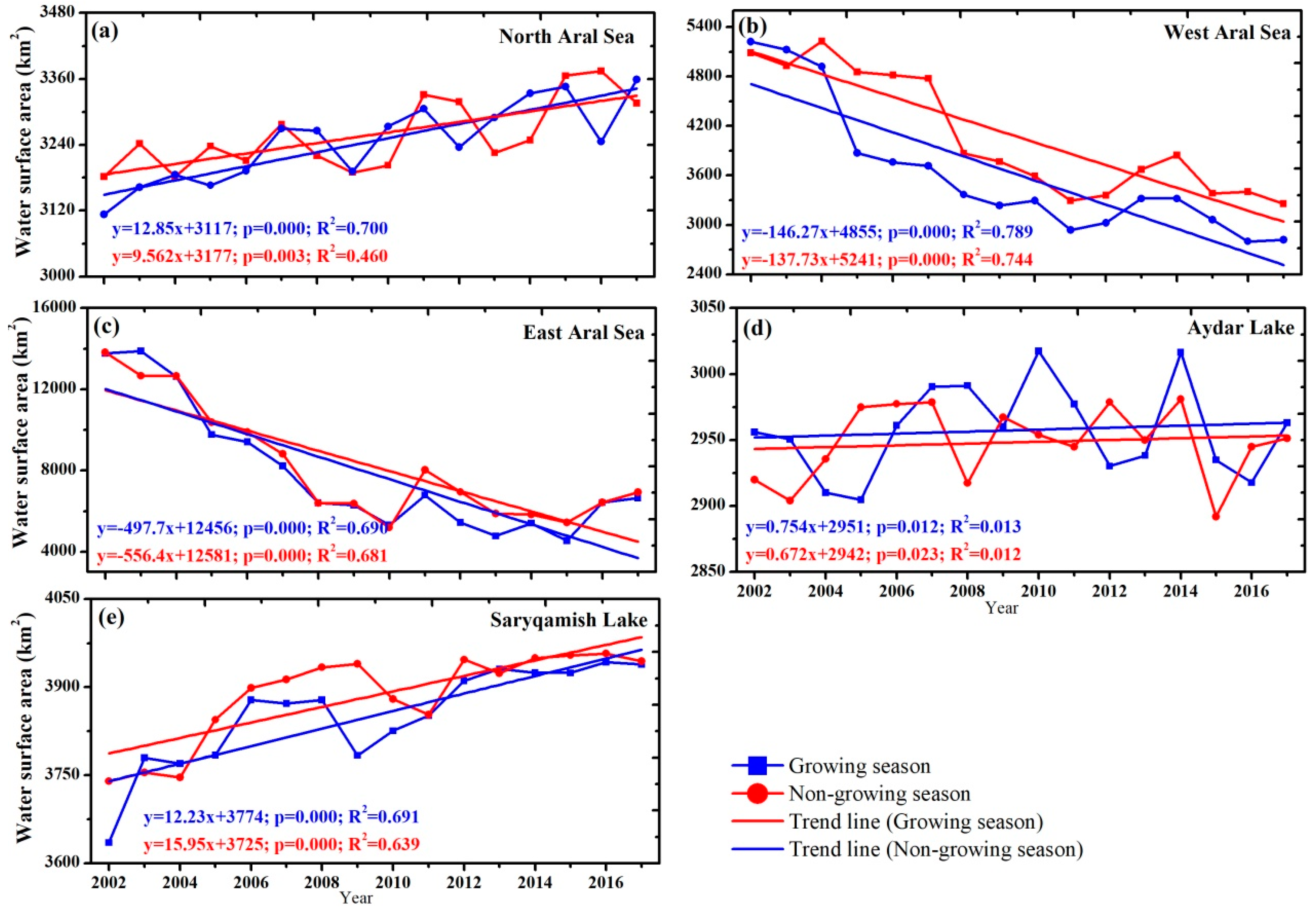
The water level has risen in only one of the three lakes in the Aral Sea region (NAS), while it has fallen sharply in the other two lakes (WAS and EAS). According to the seasonal water change in the lakes, the non-growing season has a larger water volume than the growing season. For example, from 2002 to 2017, the average water surface area in the NAS during the growing season was 3245.9 km2, while in the non-growing season, it was 3257.8 km2. In both seasons, we can see that the water level in the NAS is rising (Figure 4a). The state has undertaken several practical measures to preserve the North Aral Sea’s water volume, including implementing the Kokaral Dam project in the 2000s, aimed at impeding water loss. This initiative culminated in the successful completion of the dam in 2005. The regular supply of a certain amount of water through the Syr Darya River each year positively affects the lake’s water level. Below is a detailed description of Section 3.5 with changes in water recourse observed in the Syr Darya and Amu Darya rivers.
The findings indicate that the alteration in water level persisted in a consistent trend throughout both the West and East Aral Sea (WAS and EAS), as evidenced by the patterns illustrated in Figure 4b,c. These observations suggest that there was a noticeable escalation in the lake water level commencing in 2011, following a protracted period of decline between the years 2002 and 2010. Although the situation in the lakes has improved in recent years, the average water surface area after 2010 is much smaller than before 2010, meaning that the difference between the two periods during the growing season in the WAS and EAS is 1.07 km2 and 3.08 km2, respectively. From these two observations, we can see a significant difference between the growing and non-growing water changes, i.e., less water is observed during the growing season. After the 2000s, river water supply to the South Aral Sea (where the WAS and EAS are located) ceased entirely. Therefore, changes (decreases or increases) in seawater levels could be largely due to climate change. The relationship between marine water change and climate parameters is discussed in more detail in the Section 3.3. AL is the lake with the most stable water level in the region, and we can see that the water volume is slowly expanding with time. The trend in water surface area is also weak and insignificant in both seasons. Between 2002 and 2017, the water volume during the growing season is, on average, higher than that during the non-growing season by 0.4%. During the study period, AL’s water volume increased by an average of 0.24% and 1.04%, respectively, over two seasons. In 2010, the largest water change was observed during the growing season (3.02 km2), while in the non-growing season, it fell to the level of 2014 (2.98 km2).
Water change in SL has a significant positive trend in both seasons. Between 2002 and 2017, the lake’s water volume expanded by 5.2% and 7.7%, respectively, during the growing and non-growing seasons. The average change in water volume over the last 16 years was 34.3 km2 larger during the growing season. One of the reasons why AL and SL’s water volumes are relatively larger during the growing season can be attributed to the fact that the region uses a large amount of water resources for agriculture in this season. Because, as mentioned above, the source of AL’s water is the Syr Darya River, while the source of SL’s water is fresh water and groundwater escaping from agricultural lands. According to the statistics from the water info portal, during the growing seasons between 2002 and 2015, the average water intake for agricultural needs in the upper part of the Syr Darya (AL area) was 7.2 km3 per year and 25.86 km3 per year in the lower part of the Amu Darya (SL area). This volume is much smaller in the non-growing season, 4.1 km3 and 11.3 km3 per year from the Syr Darya and Amu Darya rivers, respectively.

3.3. Impact of Climate and Hydrologic Change on Lakes Water Storage

The effects of climate and TWS on the water storage change in the selected lakes were analyzed at a two-time scale (growing and non-growing) using the correlation method (Table 2). If we make a logical comparison of the sharp rise in these TMP and PET trend values in the LASB region (in Figure 4) and the sharp decrease in WAS and EAS water volumes in this region in 2002–2017, TMP and PET changes in WAS and EAS water during the growing season become the biggest negative influencing factors. However, a positive correlation was found between these two climate parameters and the water changes in the remaining three lakes, especially in the NAS and SL.
In the growing season, we observed strong positive correlations for PRE with WAS and EAS water change and a strong negative correlation with water storage of the other three lakes. We especially noticed a significantly strong negative relationship between SL water change and PRE in the growing season compared to the non-growing season. Furthermore, we observed a high correlation (>0.59) for GRACE-derived TWS with the water change in all lakes except AL. Among the lakes studied, EAS showed the highest positive correlation with Grace-derived TWS.

3.4. Relationships between Lake Water Change and Human Activity Factors

Table 3 shows the correlation analysis for the selected lakes. The growing season produced a positive correlation between AL and NAS, and AL and WAS. EAS recorded a significant negative correlation.
The most interesting fact is that the WAS and EAS are somewhat related to AL because they have a very strong negative relationship. We noted that the volume of the WAS and EAS’ water had decreased sharply, and the water volume of AL had been continuously expanding. With this in mind, we can conclude that AL’s water change may also be one of the main factors in reducing the water volume of lakes in the Aral Sea region (namely the WAS and EAS). Previous studies have confirmed this hypothesis [18,33]. In 1985, excessive water storage in reservoirs along the Syr Darya River and the low capacity of the small canal caused various man-made disasters in the area. Excess river water, which was to be delivered to the Aral Sea to prevent man-made disasters, was then diverted to AL [45].
Table 4 presents the results of the correlation analysis between the annual lake water change and anthropogenic factors. The NAS and SL recorded high positive correlation values with population growth and urban area expansion rates in 2002–2017, and the WAS and EAS water change formed a strong significant negative relationship with these parameters. In addition to AL and cropland, two other factors indicate a weak relationship.
In the republics located on the territory of the ASB (mainly Uzbekistan and Turkmenistan), in order to realize cotton growing, several vacant lands were developed and converted into irrigated croplands [46,47]. It was also noted in the previous sections that the population in the ASB region (Uzbekistan, Turkmenistan, Kyrgyzstan, and Tajikistan) was growing rapidly from 1960 to 2015, and the urban areas were constantly expanding [48]. Between 2002 and 2017, these factors continued to grow, with an average population growth of 24.4% (FAOSTAT, Food and Agriculture Organization of the United Nations). According to ESA-LULC data, the urban area expanded by 191.8%, and the irrigated cropland expanded by 0.19%. These factors negatively impact AS water change, especially in the southern part of the WAS and EAS water loss [26].
In order to assess the reliability of the results obtained on the Landsat-based water change in the selected lakes, we used additional MODIS water mask data [49,50]. Here, we extracted the observed annual change in the surface area of lakes from MODIS in 2002–2015 using a shapefile that defines the boundaries of each lake and compared the annual water change in the lakes from two sources (Landsat and MODIS) using the correlation method. The strong relationship between the MODIS water mask and Landsat annual lake water change shown in Table 3 proves that the two sources are very similar to each other, and the Landsat-based results are reliable.

3.5. Changes in Volume of River Water Withdrawal

The largest agricultural area is located in the basin’s lower part and is characterized as an arid zone due to low precipitation and high evapotranspiration [51,52]. The main factor in the development of an agricultural industry in arid regions is an adequate river water supply [53,54]. In general, more than 90% of the ASB’s total cropland area depends only on river water [17,55]. The water change process in the lower reaches of the Amu Darya and Syr Darya rivers is very important for the supply of the Aral Sea [33]. The amount of excess water from cropland areas in the lower part to the basin began to decline after the 1960s [46]. In the last decade, the inflow of water from the Amu Darya River to the SAS (South Aral Sea) has completely stopped [56]. However, the NAS via the Syr Darya River is supplied with a sufficient amount of stable water each year [57].
Based on the CAWater-Info data, we analyzed the water supply process in the lower reaches of the two rivers from 2002 to 2017 in growing and non-growing seasons. In the lower reaches of the Amu Darya, there is a large difference in the runoff volume observed in the two seasons (Figure 5a). The average runoff observed in recent years is 1138 km3 per year during the growing season and 285 km3 per year during the non-growing season. The high-water years in the growing season coincide with the last 2015–2017 years. From 2002 to 2017, there was a notable rise in the mean water supply in the lower Amu Darya region by 10.7%, specifically during the growing season, amounting to an annual average increase of 122.3 km3. Conversely, the non-growing season experienced a decline of 0.6%, equivalent to a decrease of −0.19 km3 per year.
In the lower reaches of the Syr Darya River (Figure 5b), water supply is also high during the growing season, with seasonal runoff being 113 km3 per year and 78 km3 per year, respectively, in the two seasons. However, in the Syr Darya River, in the growing season, the water supply rate decreased by 6.9% (−7.8 km3 per year) in recent years, while in the non-growing season, it increased by 13.6% (10.6 km3 per year).

4. Discussion

This study examined water changes in major lakes within the Aral Sea basin, as detected by Landsat. Results indicate that while some lakes experienced expansion due to increased water volume in the lakes, rivers, and groundwater, water change in the Aral Sea region was markedly reduced in both seasons by WAS and EAS water. The negative effect of AL on the reduction in the Aral Sea’s water is large, and the correlation among the five lakes is slight. Seasonal water changes reveal that more water is lost during the growing season, with the WAS water area decreasing by 2.41 km2 and 1.83 km2 during the warm and cold seasons, respectively, between 2002 and 2017. The local climate, specifically temperature (potential evapotranspiration), has a significant impact on lake water volume reduction during the warm season, as evidenced by a strong negative correlation between seasonal water storage change and temperature. Additionally, annual lake volumes are negatively correlated with water volume change and human factors such as population growth, urbanization, and cropland areas. These findings highlight the considerable human-induced impact on lake water change.
The analysis reveals a noticeable alteration in runoff during both the growing and non-growing seasons in the lower Amu Darya and Syr Darya river reaches. These findings suggest that the water supply in the area has enhanced in recent times, particularly during the growing season. Nevertheless, the augmented water runoff and the corresponding demand for water in the region are increasing simultaneously due to population growth and the continuous expansion of urban and agricultural areas. This is supported by previous studies reporting population growth and the expansion of agricultural and urban areas in the region [58].
As previously noted, an increase in water volume has been attributed to the NAS and AL river water and SL groundwater, and relatively increased WAS and EAS water changes were observed in 2016–2017. These favorable alterations can be attributed to a shift towards a more progressive water policy in the area, which is the result of practical projects aimed at preserving the Aral Sea. These initiatives are currently being implemented by the United Nations and other international organizations, as well as local authorities. The observation of positive changes may therefore be explained by the improved water policy and its associated initiatives [59].

5. Conclusions

A temporal and spatial analysis of seasonal water volume changes in the lakes located in the ASB was performed. The results show that climate and human impact equally affect the changes in the water level of lakes. During the growing season, due to high temperatures, high evaporation, and low precipitation, the change in the Aral Sea’s water volume is relatively low, compared to the non-growing season. In contrast, the water volume of Aydar and Saryqamish lakes increased during the growing season due to the high groundwater. In addition, the correlation between the water changes in lakes also shows that the increase in the Aydar Lake water volume had a negative impact on the reduction in the Aral Sea’s water. The findings of this study contribute to a better comprehension of the effects of climate and human activity on the hydrological balance of the Aral Sea. The study entailed a temporal and spatial analysis of seasonal water volume changes in lakes within the ASB region, which demonstrated that the impact of climate and human activity on water level changes in the lakes is comparable. Moreover, the study presented an enhanced processing approach for corroborating the hydrological regime with the help of multiple satellite data sources. Ultimately, this study’s results provide new insights into the evolving water resources of the Aral Sea and its basin, thereby augmenting our comprehension of this critical environmental issue.

Author Contributions

Conceptualization, T.B. and B.P.; methodology, T.B.; software, N.M.; validation, N.M., S.N. and K.G.; formal analysis, T.B.; investigation, A.T.; resources, A.T.; data curation, D.M.; writing—original draft preparation, T.B.; writing—review and editing, B.P. and N.M.; visualization, T.B.; supervision, B.P.; project administration, T.B.; funding acquisition, B.P. All authors have read and agreed to the published version of the manuscript.

Funding

This research received no external funding.

Data Availability Statement

Data used in this manuscript can be requested for research purposes from the first author [email protected].

Acknowledgments

We are grateful to the Nukus branch of Tashkent University of Information Technologies named after Muhammad Al-Khwarizmi, the Scientific Research Institute of Irrigation and Water Problems, and the University of Alabama in Huntsville for providing the opportunity to work on this study. We are also grateful to Abubaker Omer, who greatly helped us with scientific advice in the preparation of this article.

Conflicts of Interest

The authors declare no conflicts of interest.

References

  1. Deng, H.; Chen, Y. Influences of recent climate change and human activities on water storage variations in Central Asia. J. Hydrol. 2017, 544, 46–57. [Google Scholar] [CrossRef]
  2. Yegizbayeva, A.; Ilyas, S.; Berdimbetov, T. Drought Characterisation of Syrdarya River Basin in Central Asia Using Reconnaissance Drought Index. In Proceedings of the IGARSS 2022–2022 IEEE International Geoscience and Remote Sensing Symposium, Kuala Lumpur, Malaysia, 17–22 July 2022; pp. 6356–6359. [Google Scholar] [CrossRef]
  3. Timur, B. Spatio-Temporal Variations of Climate Variables and Extreme Indices over the Aral Sea Basin during 1960–2017. Trends Sci. 2023, 20, 5664. [Google Scholar] [CrossRef]
  4. Reyer, C.P.; Otto, I.M.; Adams, S.; Albrecht, T.; Baarsch, F.; Cartsburg, M.; Coumou, D.; Eden, A.; Ludi, E.; Marcus, R.; et al. Climate change impacts in Central Asia and their implications for development. Reg. Environ. Chang. 2015, 17, 1639–1650. [Google Scholar] [CrossRef]
  5. Asian Development Bank. Guidelines for Climate Proofing Investment in Agriculture, Rural Development, and Food Security; Asian Development Bank: Mandaluyong, Philippines, 2013. [Google Scholar]
  6. Small, E.E.; Sloan, L.C.; Nychka, D. Changes in Surface Air Temperature Caused by Desiccation of the Aral Sea. J. Clim. 2001, 14, 284–299. [Google Scholar] [CrossRef]
  7. Dukhovny, V.; Sokolov, V. Lessons on Cooperation Building to Manage Water Conflicts in the Aral Sea Basin; UNESCO: Paris, France, 2003. [Google Scholar]
  8. Smith, D.R. Environmental Security and Shared Water Resources in Post-Soviet Central Asia. Post-Soviet Geogr. 1995, 36, 351–370. [Google Scholar] [CrossRef]
  9. Hu, Z.; Li, Q.; Chen, X.; Teng, Z.; Chen, C.; Yin, G.; Zhang, Y. Climate changes in temperature and precipitation extremes in an alpine grassland of Central Asia. Theor. Appl. Clim. 2015, 126, 519–531. [Google Scholar] [CrossRef]
  10. Gupta, R.K.; Kienzler, K.; Martius, C.; Mirzabaev, A.; Oweis, T.; de Pauw, E.; Qadir, M.; Shideed, K.; Sommer, R.; Thomas, R.; et al. A Vision for Sustainable Land Management Research in Central Asia; Tashkent, ICARDA: Tashkent, Uzbekistan, 2009. [Google Scholar]
  11. Akramkhanov, A.R.; Kuziev, R.; Sommer, C.; Martius, C.; Forkutsa, O.; Massucati, L. Soils and soil ecology in khorezm. In Cotton, Water, Salts and Soums; Springer: Berlin/Heidelberg, Germany, 2012; pp. 37–58. [Google Scholar]
  12. Zavialov, P.O.; Kostianoy, A.G.; Emelianov, S.V.; Ni, A.A.; Ishniyazov, D.; Khan, V.M.; Kudyshkin, T.V. Hydrographic survey in the dying Aral Sea. Geophys. Res. Lett. 2003, 30, 1659. [Google Scholar] [CrossRef]
  13. Wahr, J.; Molenaar, M.; Bryan, F. Time variability of the Earth’s gravity field: Hydrological and oceanic effects and their possible detection using GRACE. J. Geophys. Res. Solid Earth 1998, 103, 30205–30229. [Google Scholar] [CrossRef]
  14. Swenson, S.; Wahr, J. Post-processing removal of correlated errors in GRACE data. Geophys. Res. Lett. 2006, 33, L08402. [Google Scholar] [CrossRef]
  15. Rodell, M.; Famiglietti, J.S.; Wiese, D.N.; Reager, J.T.; Beaudoing, H.K.; Landerer, F.W.; Lo, M.H. Emerging trends in global freshwater availability. Nature 2018, 557, 651–659. [Google Scholar] [CrossRef]
  16. Wang, L.; Wang, J.; Wang, L.; Zhu, L.; Li, X. Terrestrial water storage regime and its change in the endorheic Tibetan Plateau. Sci. Total. Environ. 2022, 815, 152729. [Google Scholar] [CrossRef] [PubMed]
  17. Tureniyazova, A.; Berdimbetov, T. Relationship between climate and land cover change in Aral Sea Basin. E3S Web Conf. 2023, 386, 06003. [Google Scholar] [CrossRef]
  18. Micklin, P. Efforts to revive the aral sea. In The Aral Sea; Springer: Cham, Switzerland, 2014; Chapter 15; pp. 361–380. [Google Scholar]
  19. Izhitskiy, A.; Ayzel, G. Water Balance of the Regulated Arid Lake as an Indicator of Climate Change and Anthropogenic Impact: The North (Small) Aral Sea Case Study. Water 2023, 15, 1464. [Google Scholar] [CrossRef]
  20. Huang, S.; Chen, X.; Ma, X.; Fang, H.; Liu, T.; Kurban, A.; Guo, J.; De Maeyer, P.; Van de Voorde, T. Monitoring Surface Water Area Changes in the Aral Sea Basin Using the Google Earth Engine Cloud Platform. Water 2023, 15, 1729. [Google Scholar] [CrossRef]
  21. Cretaux, J.F.; Kostianoy, A.; Bergé-Nguyen, M.; Kouraev, A. Present-day water balance of the aral sea seen from satellite. In Remote Sensing of the Asian Seas; Springer: Berlin/Heidelberg, Germany, 2019; pp. 523–539. [Google Scholar]
  22. Shi, W.; Wang, M.; Guo, W. Long-term hydrological changes of the Aral Sea observed by satellites. J. Geophys. Res. Oceans 2014, 119, 3313–3326. [Google Scholar] [CrossRef]
  23. Tao, D.; Shi, H.; Gao, C.; Zhan, J.; Ke, X. Water Storage Monitoring in the Aral Sea and its Endorheic Basin from Multisatellite Data and a Hydrological Model. Remote. Sens. 2020, 12, 2408. [Google Scholar] [CrossRef]
  24. Berdimbetov, T.; Shelton, S.; Pushpawela, B.; Rathnayake, U.; Koshim, A.G.; Yegizbayeva, A.; Nietullaeva, S. Use of intensity analysis and transfer matrix to characterize land conversion in the Aral Sea Basin under changing climate. Model. Earth Syst. Environ. 2024, 10, 1–13. [Google Scholar] [CrossRef]
  25. Narbayev, M.; Pavlova, V. The Aral Sea, Central Asian Countries and Climate Change in the 21st Century; United Nations ESCAP: Bangkok, Thailand, 2022; 58p. [Google Scholar]
  26. Berdimbetov, T.T.; Ma, Z.-G.; Liang, C.; Ilyas, S. Impact of Climate Factors and Human Activities on Water Resources in the Aral Sea Basin. Hydrology 2020, 7, 30. [Google Scholar] [CrossRef]
  27. Abdullaev, I.; Rakhmatullaev, S. Transformation of water management in Central Asia: From State-centric, hydraulic mission to socio-political control. Environ. Earth Sci. 2013, 73, 849–861. [Google Scholar] [CrossRef]
  28. Aizen, E.M.; Aizen, V.B.; Melack, J.M.; Nakamura, T.; Ohta, T. Precipitation and atmospheric circulation patterns at mid-latitudes of Asia. Int. J. Clim. 2001, 21, 535–556. [Google Scholar] [CrossRef]
  29. CAWater-Info. “Portal of Knowledge for Water and Environmental Issues in Central Asia.” Tashkent. 2015. Available online: http://www.cawater-info.net/ (accessed on 7 July 2024).
  30. Bernauer, T.; Siegfried, T. Climate change and international water conflict in Central Asia. J. Peace Res. 2012, 49, 227–239. [Google Scholar] [CrossRef]
  31. Liu, H.; Chen, Y.; Ye, Z.; Li, Y.; Zhang, Q. Recent Lake Area Changes in Central Asia. Sci. Rep. 2019, 9, 16277. [Google Scholar] [CrossRef]
  32. Lutz, A.F.; Droogers, P.; Immerzeel, W.W. Climate Change Impact and Adaptation on the Water Resources in the Amu Darya and Syr Darya River Basins; FutureWater: Wageningen, The Netherlands, 2012; 116p, Available online: https://www.researchgate.net/publication/256505945 (accessed on 7 July 2024).
  33. Micklin, P. The Aral Sea Disaster. Annu. Rev. Earth Planet. Sci. 2007, 35, 47–72. [Google Scholar] [CrossRef]
  34. Micklin, P. The Aral Sea Crisis and Its Future: An Assessment in 2006. Eurasian Geogr. Econ. 2006, 47, 546–567. [Google Scholar] [CrossRef]
  35. Xu, H.-J.; Wang, X.-P.; Zhang, X.-X. Decreased vegetation growth in response to summer drought in Central Asia from 2000 to 2012. Int. J. Appl. Earth Obs. Geoinform. 2016, 52, 390–402. [Google Scholar] [CrossRef]
  36. Xu, M.; Kang, S.; Wu, H.; Yuan, X. Detection of spatio-temporal variability of air temperature and precipitation based on long-term meteorological station observations over Tianshan Mountains, Central Asia. Atmos. Res. 2017, 203, 141–163. [Google Scholar] [CrossRef]
  37. Yin, G.; Mariethoz, G.; McCabe, M.F. Gap-Filling of Landsat 7 Imagery Using the Direct Sampling Method. Remote. Sens. 2017, 9, 12. [Google Scholar] [CrossRef]
  38. Zanter, K. LANDSAT 8 (L8) Data Users Handbook; United States Geological Survey: Sioux Falls, SC, USA, 2019. [Google Scholar]
  39. McFeeters, S.K. The use of the Normalized Difference Water Index (NDWI) in the delineation of open water features. Int. J. Remote Sens. 1996, 17, 1425–1432. [Google Scholar] [CrossRef]
  40. Gao, B.-C. NDWI—A normalized difference water index for remote sensing of vegetation liquid water from space. Remote Sens. Environ. 1996, 58, 257–266. [Google Scholar] [CrossRef]
  41. Javadzadeh, H.; Ataie-Ashtiani, B.; Hosseini, S.M.; Simmons, C.T. Interaction of lake-groundwater levels using cross-correlation analysis: A case study of Lake Urmia Basin, Iran. Sci. Total. Environ. 2020, 729, 138822. [Google Scholar] [CrossRef]
  42. Shen, G.; Fu, W.; Guo, H.; Liao, J. Water Body Mapping Using Long Time Series Sentinel-1 SAR Data in Poyang Lake. Water 2022, 14, 1902. [Google Scholar] [CrossRef]
  43. Sarp, G.; Ozcelik, M. Water body extraction and change detection using time series: A case study of Lake Burdur, Turkey. J. Taibah Univ. Sci. 2018, 11, 381–391. [Google Scholar] [CrossRef]
  44. Ismail, M.A.; Waqas, M.; Ali, A.; Muzzamil, M.M.; Abid, U.; Zia, T. Enhanced index for water body delineation and area calculation using Google Earth Engine: A case study of the Manchar Lake. J. Water Clim. Chang. 2021, 13, 557–573. [Google Scholar] [CrossRef]
  45. Boomer, I.; Aladin, N.; Plotnikov, I.; Whatley, R. The palaeolimnology of the Aral Sea: A review. Quat. Sci. Rev. 2000, 19, 1259–1278. [Google Scholar] [CrossRef]
  46. Lioubimtseva, E. Impact of Climate Change on the Aral Sea and Its Basin. In The Aral Sea; Springer: Berlin/Heidelberg, Germany, 2014; pp. 405–427. [Google Scholar] [CrossRef]
  47. Lioubimtseva, E.; Cole, R. Uncertainties of Climate Change in Arid Environments of Central Asia. Rev. Fish. Sci. 2007, 14, 29–49. [Google Scholar] [CrossRef]
  48. Lioubimtseva, E.; Cole, R.; Adams, J.; Kapustin, G. Impacts of climate and land-cover changes in arid lands of Central Asia. J. Arid. Environ. 2005, 62, 285–308. [Google Scholar] [CrossRef]
  49. Carroll, M.L.; DiMiceli, C.M.; Townshend, J.R.G.; Sohlberg, R.A.; Elders, A.I.; Devadiga, S.; Sayer, A.M.; Levy, R.C. Development of an operational land water mask for MODIS Collection 6, and influence on downstream data products. Int. J. Digit. Earth 2016, 10, 207–218. [Google Scholar] [CrossRef]
  50. Che, X.; Feng, M.; Sexton, J.; Channan, S.; Sun, Q.; Ying, Q.; Liu, J.; Wang, Y. Landsat-Based Estimation of Seasonal Water Cover and Change in Arid and Semi-Arid Central Asia (2000–2015). Remote Sens. 2019, 11, 1323. [Google Scholar] [CrossRef]
  51. Aitekeyeva, N.; Li, X.; Guo, H.; Wu, W.; Shirazi, Z.; Ilyas, S.; Yegizbayeva, A.; Hategekimana, Y. Drought Risk Assessment in Cultivated Areas of Central Asia Using MODIS Time-Series Data. Water 2020, 12, 1738. [Google Scholar] [CrossRef]
  52. Jiang, L.; Jiapaer, G.; Bao, A.; Li, Y.; Guo, H.; Zheng, G.; Chen, T.; De Maeyer, P. Assessing land degradation and quantifying its drivers in the Amudarya River delta. Ecol. Indic. 2019, 107, 105595. [Google Scholar] [CrossRef]
  53. Jiang, L.; Bao, A.; Jiapaer, G.; Guo, H.; Zheng, G.; Gafforov, K.; Kurban, A.; De Maeyer, P. Monitoring land sensitivity to desertification in Central Asia: Convergence or divergence? Sci. Total. Environ. 2019, 658, 669–683. [Google Scholar] [CrossRef]
  54. Jiang, L.; Jiapaer, G.; Bao, A.; Kurban, A.; Guo, H.; Zheng, G.; De Maeyer, P. Monitoring the long-term desertification process and assessing the relative roles of its drivers in Central Asia. Ecol. Indic. 2019, 104, 195–208. [Google Scholar] [CrossRef]
  55. Gafforov, K.S.; Bao, A.; Rakhimov, S.; Liu, T.; Abdullaev, F.; Jiang, L.; Durdiev, K.; Duulatov, E.; Rakhimova, M.; Mukanov, Y. The Assessment of Climate Change on Rainfall-Runoff Erosivity in the Chirchik–Akhangaran Basin, Uzbekistan. Sustainability 2020, 12, 3369. [Google Scholar] [CrossRef]
  56. Hamidov, A.; Helming, K.; Balla, D. Impact of agricultural land use in Central Asia: A review. Agron. Sustain. Dev. 2016, 36, 6. [Google Scholar] [CrossRef]
  57. Ayzel, G.; Izhitskiy, A. Climate Change Impact Assessment on Freshwater Inflow into the Small Aral Sea. Water 2019, 11, 2377. [Google Scholar] [CrossRef]
  58. Berdimbetov, T.; Ma, Z.G.; Shelton, S.; Ilyas, S.; Nietullaeva, S. Identifying Land Degradation and its Driving Factors in the Aral Sea Basin From 1982 to 2015. Front. Earth Sci. 2021, 9, 690000. [Google Scholar] [CrossRef]
  59. Libert, B.; Lipponen, A. Challenges and opportunities for transboundary water cooperation in central asia: Findings from unece’s regional assessment and project work. Int. J. Water Resour. Dev. 2012, 28, 565–576. [Google Scholar] [CrossRef]
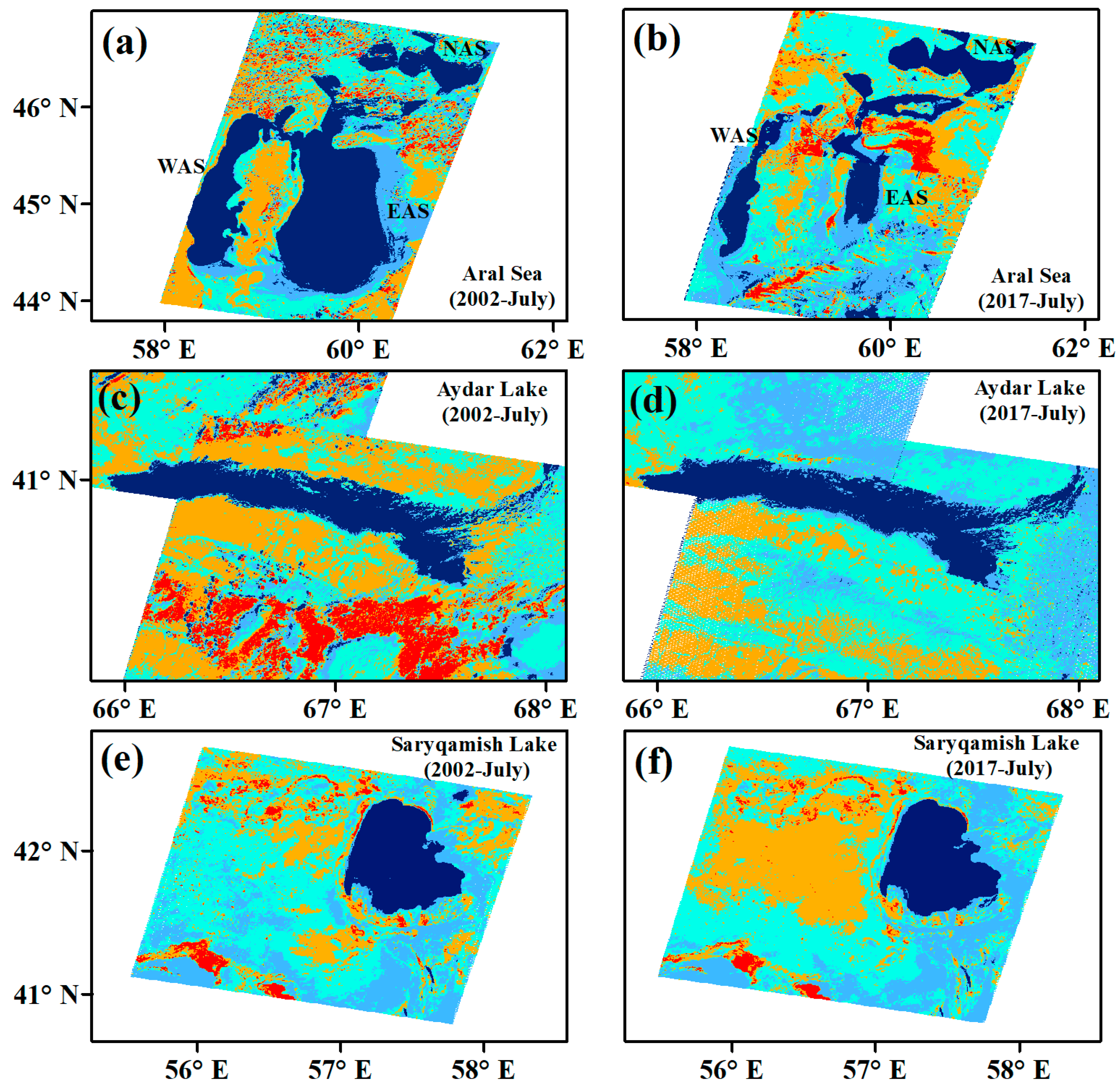
Figure 1. Water surface change in lakes selected as the study object in 2002 and 2017 (July), based on Landsat images: (a,b) Aral Sea including North Aral Sea (NAS), East Aral Sea (EAS), West Aral Sea (WAS), (c,d) Aydar Lake, and (e,f) Sarygamish Lake. The blue line outlines the lake’s shoreline.
Climate 12 00105 g001
Figure 2. The alterations in the shoreline configurations of the North Aral Sea (NAS), West Aral Sea (WAS), and East Aral Sea (EAS), as observed through Landsat images. The gray extent demarcated the total expanse of the Aral Sea in 1960. The changes in lake shorelines during July are represented by a spectrum of colors, including blue, red, and others.
Climate 12 00105 g002
Figure 3. Spatial distribution of long-term climatology (2002–2017) showing (a) temperature (TMP, °C), (b) mean annual precipitation (PRE, mm), and (c) potential evapotranspiration (PET, mm day−1).
Climate 12 00105 g003
Figure 4. The alteration of water surface area in five lakes, namely the North Aral Sea (a), West Aral Sea (b), East Aral Sea (c), Aydar Lake (d), and Saryqamish Lake (e). The blue line signifies the growing season, while the red line represents the non-growing season.
Climate 12 00105 g004
Figure 5. Runoff trends in the lower part of (a) the Amu Darya River and (b) the Syr Darya River from 2002 to 2017.
Climate 12 00105 g005
Table 1. Trend values of climate parameters for the lakes during the period of 2002–2017. Note that * represents a statistically significant trend change.
Climate ParametersLake NameSeasonMeanSlopeR-Square
TMP (°C year−y)NASNon-Growing−2.870.090.19
Growing21.100.11 *0.29
EASNon-Growing0.210.10 *0.18
Growing22.450.10 *0.24
WASNon-Growing−0.150.11 *0.18
Growing21.580.100.26
SLNon-Growing4.630.12 *0.15
Growing24.090.060.13
ALNon-Growing6.74−0.110.14
Growing24.050.050.05
PRE (mm year−R)NASNon-Growing12.710.04−0.06
Growing10.740.03−0.07
EASNon-Growing15.81−0.11 *−0.04
Growing10.16−0.16 *−0.01
WASNon-Growing15.36−0.03−0.07
Growing8.85−0.13 *−0.03
SLNon-Growing12.680.04−0.07
Growing6.13−0.17 *0.02
ALNon-Growing35.720.21 *−0.05
Growing13.06−0.12 *−0.06
PET (m day−1 year−1)NASNon-Growing0.85−0.01−0.02
Growing6.200.040.27
EASNon-Growing1.08−0.010.00
Growing6.020.040.40
WASNon-Growing1.11−0.01−0.01
Growing6.110.040.34
SLNon-Growing1.41−0.010.05
Growing6.360.020.12
ALNon-Growing1.55−0.010.09
Growing6.090.020.03
Table 2. Correlations between lake water change and other factors during growing and non-growing seasons in 2002–2017. The letters “a” and “b” indicate 90% and 95% confidence levels, respectively.
LakesTMPPREPETTWS
GrowingNAS0.52 a−0.220.56 a0.59 a
WAS−0.71 b0.71 b−0.76 b0.89 b
EAS−0.62 a0.55 a−0.68 b0.98 b
AL0.22−0.210.300.16
SL0.65 b−0.83 b0.55 a0.83 b
Non-GrowingNAS0.160.21−0.69 b−0.42
WAS0.170.290.340.86 b
EAS0.270.120.240.81 b
AL−0.22−0.650.18−0.48 a
SL−0.160.21−0.32−0.52 a
Table 3. Cross-correlation analysis between lakes’ water change in the growing and non-growing seasons. The letters “a” and “b” indicate 90% and 95% confidence levels, respectively. The time lag is assumed to be zero k = 0 .
NASWASEASALSL
GrowingNAS1−0.75 a−0.78 a0.69 a0.03
WAS-10.93 a−0.91 b−0.32
EAS--1−0.92 b−0.26
AL---10.35
SL----1
Non-growingNAS1−0.62 a−0.420.65 a−0.18
WAS-10.91−0.83 b−0.19
EAS--1−0.76 a−0.35
AL---10.11
SL----1
Table 4. Correlation analysis between lakes’ water change and human-induced water change. The letter “b” indicate 95% confidence level.
ALSLEASWASNAS
0.090.83 b−0.82 b−0.87 b0.87 bPopulationAnnual
0.170.91 b−0.15−0.88 b0.86 bUrban
0.250.14−0.86 b−0.11−0.19Cropland
0.93 b0.91 b0.85 b0.89 b0.94 bMODIS
Disclaimer/Publisher’s Note: The statements, opinions and data contained in all publications are solely those of the individual author(s) and contributor(s) and not of MDPI and/or the editor(s). MDPI and/or the editor(s) disclaim responsibility for any injury to people or property resulting from any ideas, methods, instructions or products referred to in the content.