1. Introduction
Emergency management and response are critical aspects of ensuring public safety and security [
1]. Emergencies can take many forms, including natural disasters such as hurricanes, earthquakes, and wildfires, as well as human-caused emergencies such as terrorist attacks, industrial accidents, and pandemics. Effective emergency management and response efforts can help to mitigate the impact of these emergencies, save lives, and minimize property damage. One of the key reasons that emergency management and response is so important is that emergencies can occur without warning and often require a rapid response. In many cases, emergency responders have only a few minutes or hours to act before the situation becomes more dangerous or even deadly. By having effective emergency management plans and response protocols in place, emergency responders can act quickly and decisively, potentially preventing a crisis from escalating. Another important aspect of emergency management and response is the ability to coordinate resources and personnel. In the event of a large-scale emergency, there may be many different agencies involved in the response effort, including police, fire, medical, and government organizations. Effective coordination among these groups is essential to ensure that resources are deployed in the most efficient and effective way possible [
2]. In addition to the immediate impacts of emergencies, effective emergency management and response can also help to reduce the long-term impacts of disasters. By having effective plans and procedures in place, communities can potentially minimize the economic and social impacts of disasters and facilitate a more rapid recovery.
The Internet of Emergency Services (IoES) is a term used to describe the integration of Internet of Things (IoT) devices and systems into emergency management and response. This integration aims to improve the speed and efficiency of emergency response, by providing real-time data and enabling better coordination among various agencies involved in emergency management and response efforts. The definition of IoES can vary slightly depending on the source, but it generally refers to the use of internet-connected devices and technologies for emergency services. This can include sensors and IoT devices that are used to collect real-time data, as well as communication and coordination systems that enable emergency responders to work together more effectively.
One important aspect of IoES is its potential to enhance public safety and crisis management efforts. By providing real-time data and enabling faster response times, IoES can help to minimize the impact of emergencies and reduce the risk to citizens. Additionally, the integration of IoT devices and systems can help to improve the overall efficiency and effectiveness of emergency services, by enabling better coordination and communication among different agencies. While the specific applications of IoES may vary depending on the context, the goal is always to enhance public safety and ensure that emergency responders are able to provide the best possible care to those in need.
The previous review paper on related topics of emergency/disaster reponse have been summarized in
Table 1.
The aim of this paper is to explore the potential impact of integrating Internet of Things (IoT) devices and systems into emergency management and response, specifically through the concept of Internet of Emergency Services (IoES). The paper aims to provide an overview of the applications and benefits of IoES, as well as to address the challenges and risks associated with its implementation.
The novelty of this paper lies in its focus on the integration of IoT devices and systems specifically for emergency management and response, through the concept of IoES. While there is existing research on the use of IoT in various contexts, this paper contributes to the development of a specific framework for the use of IoT in emergency services. Additionally, the paper explores the potential impact of IoES on public safety and crisis management, providing insights into the importance of this emerging field.
The contributions of this paper are twofold. First, it provides a comprehensive overview of the potential benefits and applications of IoES, including real-time data collection and analysis, communication and coordination, and improved emergency response times. Second, the paper addresses the challenges and risks associated with the implementation of IoES, such as data privacy and security concerns, technical limitations, and ethical considerations. By providing insights into both the benefits and challenges of IoES, this paper contributes to the development of a more responsible and effective approach to emergency management and response through the use of IoT devices and systems.
To guide our research, we formulate the following research questions:
What are the potential applications and benefits of integrating IoT devices and systems into emergency management and response through the concept of Internet of Emergency Services (IoES)?
What are the challenges and risks associated with the implementation of IoES in emergency management and response, including data privacy and security concerns, technical limitations, and ethical considerations?
How can IoES be effectively and responsibly implemented in emergency management and response to maximize its potential benefits while mitigating its associated risks and challenges?
What is the impact of IoES on public safety and crisis management, including improved response times, enhanced communication and coordination, and more efficient resource deployment?
What are the implications of IoES for emergency management and response policies and practices, and how can they be adapted to effectively integrate IoT devices and systems?
The paper further provides background information on IoT and sensors, including their various applications in emergency management (
Section 2). (The paper presents the research framework of the Internet of Emergency Services in
Section 3. The use cases and application scenarious of IoES are analyzed in
Section 4. The paper discusses the potential benefits of real-time data collection and analysis, coordination and communication, and the impact of IoT and IoES on public safety and crisis management, and addresses the challenges, risks, and limitations associated with implementing and using IoT and IoES in emergency management in
Section 5. Finally, the paper concludes with a summary of key findings and recommendations for the effective and responsible use of IoT and IoES in emergency management (
Section 6).
2. Background on Internet of Things (IoT) and Sensors
2.1. Methodology
For the literature search, the following electronic databases were used: Scopus, Web of Science, and Google Scholar. The search keywords used were “emergency management”, “disaster response”, “disaster relief”, “emergency technology”, “crisis management”, “natural disasters”, “artificial intelligence”, “blockchain”, “smart cities”, and “smart helmets”. The initial search resulted in a total of 165 articles. After screening the articles based on their title, abstract, and full text, 131 articles were selected for inclusion in the final analysis. The selection process was based on the relevance of the article to the topic of emergency management and response, the inclusion of technology in the article, and the year of publication (2011–2022). The search was conducted in June 2022, and only articles published before that date were included in the review.
2.2. IoT Technology and Generic IoT Architecture
The Internet of Things (IoT) is a technology that enables the connection and communication of devices and objects over the internet [
13,
14]. IoT devices are equipped with sensors, which allow them to collect data on a variety of physical and environmental conditions. This data can then be transmitted to other devices or systems, where it can be analyzed and used to inform decision making. IoT sensors come in a variety of forms, including temperature sensors, humidity sensors, motion sensors, and pressure sensors [
15]. They can be used to collect data on a wide range of environmental conditions, such as temperature, humidity, air quality, and sound levels. They can also be used to monitor infrastructure, such as bridges, roads, and buildings, and to track the movement of people and goods. The development of IoT technology has been driven by the increasing availability of low-cost sensors, as well as advances in wireless communication [
16,
17,
18] and cloud computing [
19,
20,
21,
22]. These developments have made it possible to collect and process large amounts of data in real-time, enabling new possibilities for monitoring and analysis.
One of the key benefits of IoT technology is its ability to provide real-time monitoring and response [
23,
24]. By collecting data on environmental conditions and infrastructure status, IoT sensors can alert emergency responders to potential emergencies before they become critical. For example, an IoT sensor on a bridge can detect when the bridge is starting to deteriorate and send an alert to maintenance personnel, enabling them to take action before the bridge becomes unsafe [
25]. IoT sensors can also be used to automate certain emergency response processes, such as sending alerts or deploying resources [
26]. For example, an IoT sensor on a fire hydrant can detect when it has been opened and automatically send an alert to the fire department, enabling them to respond more quickly to the emergency. The development of IoT technology and sensors has opened up a range of new possibilities for emergency response and management. By harnessing the power of IoT technology, it is possible to improve the speed, accuracy, and effectiveness of emergency response efforts, and to minimize the impact of emergencies on individuals and communities.
The generic architecture of the Internet of Things (IoT) shown in
Figure 1 consists of three layers: the device layer, the network layer, and the application layer, as follows:
The device layer includes devices such as sensors, actuators, and other types of input/output devices that can be used to collect data from the physical environment or take action on it. Sensors are used to collect data on environmental conditions such as temperature, humidity, or air quality. Actuators, on the other hand, can be used to control devices or systems in response to data collected by sensors.
The network layer includes a network that connects the devices to the cloud, as well as a gateway that enables communication between the devices and the cloud. The cloud serves as a central hub for storing and processing the data collected by the devices.
The application layer includes the software applications that are used to analyze and make decisions based on the data collected by the devices. This layer is responsible for processing the data and presenting it to the user in a meaningful way.
In this architecture, the flow of data starts with the environment, where sensors collect data on physical and environmental conditions. This data is then sent to the devices, where it is processed and sent to the gateway. The gateway then sends the data to the cloud, where it is stored and processed by the application layer. The application layer analyzes the data and sends reports to the user, who can then take action based on the information received. The application layer can also send feedback to the user based on the data collected by the devices. This generic IoT architecture provides a framework for collecting and processing data from the physical environment, and using it to make informed decisions and take action.
Figure 1.
Generic architecture of the Internet of Things.
Figure 1.
Generic architecture of the Internet of Things.
2.3. Applications of IoT in Emergency Management
IoT technology has a wide range of potential applications in emergency management, from early warning systems to real-time monitoring and response. One of the key applications of IoT in emergency management is in the area of disaster detection and warning [
27,
28,
29,
30]. IoT sensors can be used to detect natural disasters such as earthquakes, hurricanes, and floods, and to issue real-time alerts to authorities and the public [
31,
32,
33]. These alerts can help to reduce the impact of disasters by giving people time to evacuate or take other appropriate action. Another application of IoT in emergency management is in the area of real-time monitoring and response. IoT sensors can be used to monitor a range of environmental and infrastructure factors, including air quality, water levels, and structural integrity. These data can be used to identify emerging emergencies and to coordinate a rapid response by emergency responders [
34,
35,
36,
37,
38]. IoT technology can also be used to track the movement of people and resources during emergencies [
10,
39]. For example, wearable IoT devices can be used to track the location and condition of emergency responders, while GPS-enabled devices can be used to track the location of emergency vehicles and supplies. This information can be used to coordinate a more effective response and to ensure that resources are deployed where they are most needed. Another application of IoT in emergency management is in the area of post-disaster recovery and reconstruction [
40,
41]. IoT sensors can be used to monitor the condition of buildings and infrastructure in the aftermath of a disaster, and to identify areas that require repair or reconstruction. This information can be used to guide the allocation of resources and to ensure that recovery efforts are targeted and effective.
The potential applications of IoT in emergency management are vast and varied. By harnessing the power of IoT technology, it is possible to improve the detection, response, and recovery from emergencies and to reduce the impact of disasters on individuals and communities.
2.4. Advantages and Disadvantages of IoT for Emergency Response
We can summarize the advantages of IoT for emergency response, as follows:
Real-time monitoring [
42,
43]: IoT sensors can provide real-time data on environmental conditions, infrastructure status, and people movement during an emergency. This information can help emergency responders make better decisions and respond more quickly to the emergency.
Early detection [
29,
44,
45]: IoT sensors can detect emergencies, such as natural disasters or infrastructure failures, before they become critical. This early detection can help to prevent emergencies from becoming more severe and dangerous.
Improved communication [
16,
46,
47,
48]: IoT technology can improve communication among emergency responders and with the public. This can help to coordinate a more effective response and keep people informed and safe during an emergency.
Automated response [
49,
50,
51]: IoT technology can automate certain emergency response processes, such as sending alerts or deploying emergency resources. This automation can save valuable time and reduce the potential for human error.
The disadvantages of IoT for an emergency response include:
Reliability: IoT sensors may not always be reliable, especially in extreme weather conditions or other emergency situations. This can lead to false alarms or delays in response.
Technical expertise: IoT technology requires specialized technical expertise to install and maintain. This can limit its adoption in some areas or by some organizations that do not have the necessary expertise.
The advantages of IoT technology for an emergency response outweigh the disadvantages. However, it is important to carefully consider the potential drawbacks and address them appropriately to ensure that IoT technology is used effectively and safely in the emergency response.
2.5. Motivation for IoES
The motivation for extending the use of IoT technology in an emergency response is driven by the need to improve the effectiveness and efficiency of emergency management. Traditional emergency response systems have relied on manual processes and human intervention, which can be slow and prone to error [
52]. IoT technology can help to automate and streamline emergency response processes, providing real-time data and insights that can enable faster and more effective responses. Additionally, the increasing frequency and severity of natural disasters, climate change, and other emergencies have highlighted the need for more advanced and innovative emergency response solutions. IoT technology offers a range of new possibilities for an emergency response, including early detection and warning systems, real-time monitoring and response, and post-disaster communications, recovery, and reconstruction [
53,
54]. Furthermore, the COVID-19 pandemic has demonstrated the need for more advanced and adaptive emergency response systems that can respond quickly to rapidly changing circumstances [
55,
56]. IoT technology can play a key role in these efforts, enabling remote monitoring and response, contact tracing, and other critical functions.
Therefore, the motivation for extending the use of IoT technology in an emergency response is driven by the need for more effective and efficient emergency management solutions that can adapt to a rapidly changing world. By harnessing the power of IoT technology, it is possible to improve the speed, accuracy, and overall effectiveness of emergency response efforts, and to minimize the impact of emergencies on individuals and communities.
3. Research Framework of Internet of Emergency Services
3.1. Taxonomy of Concepts and Reference Model
The Internet of Emergency Services (IoES) utilizes the Internet of Things (IoT) and related technologies to enhance emergency response and management. A taxonomy of concepts related to the IoES can be categorized into three main areas:
Devices and Sensors: This category refers to the physical components of the IoES, such as sensors and devices that collect and transmit data. Examples of devices include wearables, smart helmets, drones, and robots. Sensors can range from environmental sensors that monitor air quality, temperature, and humidity to biometric sensors that measure heart rate, blood pressure, and oxygen levels. These devices and sensors can be used to detect and monitor emergency situations, collect real-time data, and provide situational awareness.
Communication and Networking: This category refers to the means by which the IoES components communicate and share data. This includes various communication protocols, such as WiFi, Bluetooth, and cellular networks, as well as computation paradigms such as edge computing, fog computing, and cloud computing. Communication and networking enable real-time data sharing, efficient information exchange, and collaboration among various stakeholders involved in the emergency response.
Data Management and Analysis: This category refers to the methods and tools used to manage and analyze the data collected by IoES devices and sensors. This includes data storage, processing, analysis, and visualization. Machine learning algorithms, artificial intelligence, and big data analytics can be used to analyze the vast amounts of data collected by the IoES and provide insights into emergency situations. This can aid in decision making, resource allocation, and emergency response planning.
The taxonomy of concepts in the IoES highlights the diverse and complex components involved in enhancing emergency response and management. By leveraging the latest advancements in IoT technologies, the IoES can provide real-time, data-driven insights that can lead to a faster and more efficient emergency response, ultimately saving lives and reducing the impact of disasters.
The Reference Model of the IoES is a conceptual framework that describes the components and interactions of a system that uses the Internet of Things (IoT) and other advanced technologies to enhance emergency response.
Figure 2 presents a detailed and comprehensive description of the IoES Reference Model.
User/Citizen: This component represents the individuals who may need emergency services. The users/citizens interact with the IoES through various channels, such as mobile apps, web portals, or phone calls.
Emergency Management Center (EMC): The EMC is the core component of the IoES, responsible for coordinating emergency services. It receives emergency requests from the users/citizens and dispatches the appropriate response teams to the scene. The EMC also collects and analyzes data from various sources to improve the emergency response.
IoT Devices: These devices are the primary source of data for the IoES. They are equipped with various sensors and communication technologies that enable them to collect and transmit data on a range of physical and environmental conditions, such as temperature, humidity, air quality, and sound levels.
Communication Networks: The IoES relies on various communication networks to transmit data between the different components. These networks include cellular networks, Wi-Fi, Bluetooth, and other emerging technologies, such as 5G and LoRaWAN.
Cloud Computing: The IoES leverages cloud computing to process and store the large amounts of data generated by the IoT devices. Cloud computing enables real-time analysis of data and provides a scalable and secure infrastructure for the IoES.
Artificial Intelligence (AI): AI technologies are used in the IoES to enhance emergency response. AI algorithms can analyze large amounts of data from various sources to detect patterns and anomalies, predict future events, and provide recommendations for response teams.
Geographic Information Systems (GIS): GIS technologies are used in the IoES to visualize and analyze spatial data. GIS enables emergency responders to understand the geographic context of the emergency and make informed decisions [
57].
Wearable Devices: Wearable devices are a type of IoT device that can be worn by emergency responders to collect data on their physical condition, such as heart rate, temperature, and movement. Wearable devices can also be used to track the location of emergency responders and communicate with the EMC.
Unmanned Aerial Vehicles (UAVs): UAVs, also known as drones, can be used in the IoES to collect data from the air. UAVs equipped with cameras and other sensors can provide real-time video feeds of the emergency scene, detect hazards, and locate victims [
47,
58,
59].
Augmented Reality (AR) and Virtual Reality (VR): AR and VR technologies can be used in the IoES to provide emergency responders with immersive and interactive training experiences. AR and VR can also be used to visualize and analyze data in real-time, enhancing situational awareness [
29,
60].
Blockchain: Blockchain technology can be used in the IoES to provide a secure and transparent record of emergency response activities. Blockchain can also be used to manage the distribution of emergency resources and track their use [
61,
62,
63].
Data Analytics: Data analytics is a critical component of the IoES. Data analytics technologies enable the IoES to analyze and make sense of the large amounts of data generated by the IoT devices. Data analytics can also be used to identify patterns and trends in emergency response data, providing insights for future improvements.
In summary, the IoES Reference Model provides a comprehensive view of the components and interactions of a system that uses advanced technologies to enhance the emergency response. The IoES leverages IoT devices, communication networks, cloud computing, AI, GIS, wearables, UAVs, AR/VR, blockchain, and data analytics to improve the emergency response and save lives.
3.2. Components and Devices of Internet of Emergency Services
3.2.1. Sensors
Sensors play a crucial role in collecting data for IoES to help manage and respond to emergency situations. They can be used to gather various types of information such as temperature, humidity, air quality, radiation levels, and more. This information is then used to make decisions, monitor the situation, and take appropriate actions. In this discussion, we will explore some of the various types of sensors used in IoES and provide examples of their uses in emergency management and response.
Environmental sensors can measure various aspects of the environment, such as temperature, humidity, air quality, and radiation levels. These sensors can provide valuable information for emergency responders to assess the situation and take appropriate actions. For example, during a natural disaster such as a hurricane or flood, environmental sensors can be used to monitor the water levels, air quality, and other environmental conditions.
Motion sensors are used to detect movement or changes in movement. These sensors can be used to detect human presence, vehicle movement, or even the movement of debris after a disaster. They are particularly useful in detecting survivors in collapsed buildings or landslides, as they can detect the smallest of movements and vibrations.
Gas sensors are used to detect the presence of harmful gases such as carbon monoxide, methane, and sulfur dioxide. These sensors can be used to detect gas leaks or toxic gases in the environment. They are particularly useful in industrial accidents, where toxic gases can pose a significant risk to human health and safety.
Sound sensors are used to detect the presence of sound or changes in sound. These sensors can be used to detect the sounds of distress signals, such as someone shouting for help or the sound of an explosion. They can also be used to detect changes in sound patterns, such as the sound of a building collapsing.
Pressure sensors can be used to detect changes in pressure or force. They can be used to detect changes in air pressure or water pressure, which can indicate a leak or rupture. They are particularly useful in detecting underground leaks or changes in water pressure during a flood.
Real-world examples of the use of sensors in emergency management and response include:
Earthquake monitoring [
16,
64]: During an earthquake, sensors are used to monitor the ground motion and seismic activity. This information is then used to issue alerts and warnings to the public and emergency responders.
Air quality monitoring [
32,
65]: In areas affected by wildfires, sensors are used to monitor the air quality and detect the presence of harmful gases and particulate matter. This information is used to issue health warnings and advise people to take appropriate precautions.
Flood monitoring [
27,
28,
58]: During floods, sensors are used to monitor the water levels and detect changes in water pressure. This information is used to issue alerts and warnings to the public and emergency responders.
Chemical spill detection [
66,
67]: Sensors are used to detect the presence of hazardous chemicals and toxic gases in the environment. In the event of a chemical spill, sensors can be used to monitor the concentration of chemicals in the air and water.
In conclusion, sensors play a crucial role in IoES by providing real-time data to emergency responders. They are used to monitor the environment, detect changes in movement, detect the presence of harmful gases, and detect changes in pressure. Real-world examples of sensor use in emergency management and response include earthquake monitoring, air quality monitoring, flood monitoring, and chemical spill detection (see a list of papers presented in
Table 2).
3.2.2. Actuators
Actuators are devices that convert energy into motion, such as motors, solenoids, and hydraulic and pneumatic cylinders. In the context of the Internet of Emergency Services (IoES), actuators can play an important role in responding to emergencies by enabling automated actions and the remote control of physical devices. Here are some examples of actuator use in emergency management and response:
Automated water shutoff valves: In the event of a water pipe rupture or other water-related emergency, automated water shutoff valves can be used to quickly stop the flow of water and prevent further damage. These valves can be remotely controlled using IoES technologies, such as IoT sensors and cloud computing.
Autonomous robots [
72,
73]: Robots equipped with actuators, such as motors and grippers, can be used to perform various emergency response tasks, such as search and rescue, firefighting, and hazardous material cleanup. For example, the RoboCup Rescue competition encourages the development of autonomous robots for disaster response.
Emergency lighting [
68]: Actuators can be used to control emergency lighting systems, such as turning on exit signs and emergency lights during power outages or other emergencies.
Automated door locks: In the event of a security breach or other emergency situation, automated door locks can be used to quickly secure a building or area. These locks can be controlled remotely using IoES technologies, such as mobile devices or cloud computing.
Remote vehicle control [
43,
58,
74,
75,
76]: Actuators can be used to remotely control vehicles, such as drones or unmanned ground vehicles, for emergency response tasks. For example, drones equipped with actuators can be used for search and rescue operations or to provide real-time situational awareness during an emergency.
While the use of actuators in IoES can provide significant benefits for emergency management and response, there are also some challenges and limitations to consider. One major challenge is ensuring the reliability and security of the actuators themselves, as well as the communication channels used to control them. Additionally, there may be concerns about privacy and data protection when using IoES technologies to remotely control physical devices. Overall, careful planning and implementation are necessary to ensure the effective and responsible use of actuators in IoES for emergency management and response.
3.2.3. Wearable Devices
Wearable devices are electronic devices that can be worn on the body and are capable of collecting, processing, and transmitting data in real-time. They have become increasingly popular in emergency management and response due to their ability to provide critical information about the physical state and location of individuals in emergency situations [
12].
One of the most important applications of wearable devices in emergency management and response is in search and rescue operations [
5,
49]. Wearable devices can be used to monitor vital signs and detect the location of individuals who are trapped or lost in disaster situations. For example, the Los Angeles County Sheriff’s Department uses wearable devices to track the heart rate, body temperature, and other physiological data of search and rescue team members during missions. Another application of wearabledevices is in monitoring the health and safety of emergency responders. In hazardous environments, such as wildfires or chemical spills, wearable devices can detect toxic gases, monitor radiation levels, and provide alerts in case of dangerous conditions. The New York City Fire Department is currently testing wearable devices to monitor the exposure of firefighters to toxic chemicals and gases [
12,
49].
Wearable devices can also be used to monitor the physical and mental health of individuals during emergency situations. For instance, during the COVID-19 pandemic, wearable devices were used to track the temperature and respiratory rate of patients in hospitals and quarantine centers [
77]. In addition, wearable devices can be used to monitor the stress and emotional state of individuals during and after disasters, providing valuable insights into the psychological impact of emergency situations. However, the use of wearable devices in emergency management and response is not without challenges and limitations. One major challenge is the accuracy and reliability of the data collected by these sensors. Factors such as movement, sweat, and skin color can affect the accuracy of vital sign measurements. Additionally, the privacy and security of the data collected by wearable devices must be carefully managed to ensure the confidentiality and protection of individuals’ personal information.
In conclusion, wearable devices have great potential in emergency management and response, providing critical data for search and rescue operations, monitoring the health and safety of emergency responders, and tracking the physical and mental health of individuals during and after disasters (see a list of papers in
Table 3). However, careful attention must be paid to the accuracy, reliability, privacy, and security of the data collected by these sensors.
3.2.4. Unmanned Aerial Vehicles (UAVs)
Unmanned Aerial Vehicles (UAVs), commonly referred to as drones, have become increasingly popular in emergency management and response due to their ability to provide situational awareness, assess damage, and deliver critical supplies to inaccessible areas [
51]; please see a list of papers in
Table 4. The use of drones in emergency response and management is rapidly expanding as new technology is developed and regulations are put in place. One of the primary benefits of using drones in emergency management is their ability to provide real-time situational awareness. The drones (such as shown in
Figure 3) may have a high resolution camera to capture an overhead view of the disaster area, as well as communication networking infrastructure to send photos in real-time. By capturing high-resolution images and video, drones can quickly survey an area affected by a disaster, allowing emergency responders to identify critical needs and allocate resources more effectively. In order to alleviate the burden of backhaul for UAVs, important data can be cached by rescuers on the ground equipped with caching capabilities and transmitted directly to victims via device-to-device (D2D) communication [
80]. For example, in the aftermath of Hurricane Harvey in 2017, the Federal Emergency Management Agency (FEMA) used drones to conduct search and rescue operations and assess damage in inaccessible areas.
Drones are also being used to deliver critical supplies to areas that are difficult to access due to damage or other hazards. In 2016, the United Nations Development Programme (UNDP) used drones to deliver medical supplies to remote areas in Vanuatu that were affected by Cyclone Pam. Similarly, in 2017, the Red Cross used drones to deliver food and water to areas affected by Hurricane Harvey. In addition to their use in response efforts, drones are also being used in preparedness and mitigation activities [
10,
27,
81,
82]. For example, drones can be used to map flood-prone areas and assess the risk of landslides, allowing emergency management officials to develop more effective evacuation plans and other mitigation measures.
Despite their many benefits, the use of drones in emergency management and response also presents several challenges and limitations. One of the primary challenges is the need to navigate complex regulations related to airspace and privacy. In many cases, emergency management officials must obtain permission from the Federal Aviation Administration (FAA) before deploying drones in disaster areas, which can slow down response efforts. Another challenge is the limited battery life of most drones, which can restrict their ability to operate for extended periods of time. Additionally, adverse weather conditions such as high winds and heavy rain can prevent drones from being used effectively.
The use of drones in emergency management and response has the potential to significantly improve situational awareness, deliver critical supplies, and assist in preparedness and mitigation efforts [
82]. However, careful consideration must be given to the regulatory and technological challenges associated with their use. As technology continues to evolve and regulations become more streamlined, the use of drones in emergency management and response is likely to become increasingly common.
Figure 3.
Example of a NEO drone which can be used as a Mobile Sensing Platform for Disaster Response and Public Safety [
83].
Figure 3.
Example of a NEO drone which can be used as a Mobile Sensing Platform for Disaster Response and Public Safety [
83].
Table 4.
Summary of UAVs for Emergency Management and Response.
Table 4.
Summary of UAVs for Emergency Management and Response.
| Reference | UAV | Context of Use | Description of Use |
|---|
| Coutinho and Boukerche (2021) [84] | UAV-mounted cloudlet system | Multiplant and industrial zones | Computation, communication, and storage resources to support first responders during search and rescue operations. This can include surveillance of the affected area, real-time monitoring of search and rescue (SAR) team members and victims, and caching nodes to improve content delivery among SAR teams |
| Seo et al., (2017) [37] | UAV and beacons | Building emergency response | Secure communication system can be established between unmanned aerial vehicles (UAVs), smart sensors, a control server, and a smartphone app for security managers. This will enable better coordination between smart sensors and indoor/outdoor UAVs, as well as the use of beacons for rescue and building evacuation. |
| Alawad et al., (2023) [74] | Search and rescue team | Disaster and crisis management | Swarm optimization algorithm (SOA) to avoid choosing a less-than-ideal solution and obtain the global maximum in the search space. UAV was directed to victim groups discovered during the investigative phase after a probable catastrophe zone was investigated. |
| Mukherjee et al., (2021) [85] | Consumer drones | Emergency message transfer among smart grid systems and power sources in a disaster scenario | A framework for the Consumer Internet of Drone Things (CIoDT) was put into place, together with an edge-enabled opportunistic MQTT message transmission mechanism and a specific network slice for testing routing performance. |
| Niu et al., (2022) [86] | UAVs and ground mobile devices | Collaborative computing for task scheduling problem in disaster scenarios | Two-stage Lyapunov optimization problem to represent the workload scheduling problem for catastrophe situations and suggested a distributed computing network made up of ground mobile devices and UAVs. As a deterministic optimization issue, the long-term stability of work queues for system nodes is decoupled. Task sizes are jointly tuned for transmission from the control center to the UAVs, computation locally and offloading by the UAVs, and to reduce energy consumption while guaranteeing the stability of computation queues. |
| Sun et al., (2022) [42] | UAV, IoT, and DT technologies | Building two-mode monitoring systems for industrial facilities and adjacent territories | A process for developing two-mode monitoring systems for industrial facilities and surrounding areas that applies DT, IoT, and UAV technologies as well as a number of reliability models. created the von Neumann paradigm for the synthesis of trustworthy systems out of untrustworthy parts. The use of multiple forms of redundancy (structural, version, time, and space) for fundamental components—sensors, means of communication, processing, and presentation—in the form of DTs for decision support systems is covered by the concept for complex SMs of industrial facilities. There were examples of SMs used in manufacturing and nuclear power facilities. |
| Khan et al., (2022) [27] | UAVs | Disaster management | Lets anyone affected by natural or man-made catastrophes to communicate wirelessly quickly, affordably, easily, and securely. Explains the problems and difficulties of UAV-based infrastructure and security concerns confronted and gives the most recent state-of-the-art solutions to these problems. |
| Hernandez et al., (2022) [58] | Drones | Disaster surveillance and monitoring | Drone-sourced natural disaster imagery processing pipeline powered by AI to cut down on the volume of photographs that need to be analyzed by first responders. A lightweight deep learning-based autoencoder, dimensionality reduction using t-distributed stochastic neighbor embedding (i-SNE), and fuzzy clustering are all parts of the process. Assesses the design of intelligent autonomous drones to deliver this service in real-time by evaluating the pipeline on several edge computing platforms with low-power accelerators. |
| Yang et al., (2022) [87] | UAVs | Post-disaster data dissemination | Creates a challenge for the distribution of data utilizing a number of unmanned aerial vehicles (UAVs) in a post-disaster region while maximizing their trajectory, mission completion time, and energy use. Optimizes the trajectory and mission completion time of the considered UAV as well as the total energy consumption by using the block coordinate descent method and the bisection search approach to solve the complete problem. |
| Çalhan and Cicioğlu (2022) [59] | Drones | Pandemic data gathering | Smart data collection with drone assistance for pandemic circumstances to collect massive data in chaotic and crowded catastrophe zones. |
| Pan et al., (2022) [43] | Environmental monitoring | Emergency response | UAV-aided emergency environmental monitoring system using a LoRa mesh networking approach |
| Tehseen et al., (2022) [44] | Forest fire detection and counteraction | Emergency response | IoT and drone-based forest fire detection and counteraction system |
| Bushnaq et al., (2021) [76] | Wildfire detection | Emergency response | Wildfire detection solution based on unmanned aerial vehicles assisting IoT networks |
| Alsamhi et al., (2021) [47] | Disaster management | Emergency response | Collaboration between IoT and drone edge intelligence to gather and process data, extend wireless coverage, and provide real-time information |
| Feng et al., (2020) [17] | Multi-UAV | Emergency communications framework in disaster scenarios | Emergency communications framework of NOMA-based UAV-aided networks in disaster scenarios, including UAV-enabled uplink NOMA system, a joint UAV deployment and resource allocation scheme for multi-UAV enabled NOMA system, and a UAV equipped with an antenna array to provide wireless service for multiple devices in disaster areas. |
| Wang et al., (2020) [88] | UAV | Emergency scenarios | Solving dynamic cluster formation and spectrum sharing problems in stochastic environments for UAV-assisted information diffusion in emergency scenarios, using device-to-device (D2D) multicast manner, many-to-one matching game, and dynamic hypergraph coloring approach. |
| Ejaz et al., (2020) [89] | UAV | Disaster management | Energy-efficient task scheduling scheme for data collection by UAVs from the ground IoT network in disaster management, optimizing the path taken by the UAVs to minimize energy consumption, and applying decision tree classification algorithm to determine health risk status of people in disaster-affected areas. |
| Liu and Ansari (2019) [90] | UAV | Disaster rescue | UBS network access and resource allocation scheme to maximize the number of human portable/wearable MTDs (HMTDs) to establish communications via unmanned aerial vehicle-mounted base stations (UBS) when local cellular infrastructure is destroyed by a disruptive disaster. |
| Ahn et al., (2018) [91] | UAV | Disaster rescue | Realistic network simulation platform for UAV communication to develop reliable FANETs in disaster rescue operations where reliable and on-time transmission of rescue information is critical. |
3.2.5. Terrestrial Robots
Terrestrial robots are becoming increasingly important in the context of emergency management and response due to their ability to operate in hazardous environments and perform tasks that are dangerous for human rescuers [
7,
11]. These robots are equipped with various sensors, cameras, and other tools that enable them to collect data, search for survivors, and perform search and rescue operations. Here, we present a discussion on the use of terrestrial robots for IoES (see
Table 5), along with some real-world examples.
One of the most significant advantages of using terrestrial robots for emergency management is their ability to operate in hazardous environments, such as buildings that have collapsed due to earthquakes, landslides, or other disasters [
73]. These robots can enter the damaged structures and search for survivors, collect data, and perform various tasks that are critical for emergency response. For example, after the 2011 earthquake and tsunami in Japan, the Tokyo Fire Department deployed a number of robots to search for survivors in the debris. These robots were equipped with cameras and other sensors that enabled them to detect the presence of living beings and provide data to rescue teams. Similarly, after the 2017 earthquake in Mexico, several organizations deployed robots to search for survivors in the rubble.
Another significant advantage of terrestrial robots is their ability to navigate in challenging terrain, such as forests, mountains, and other remote areas. This is especially important in situations where conventional vehicles cannot access the area due to roadblocks or other obstacles. Terrestrial robots equipped with GPS and other navigation systems can be used to collect data and provide situational awareness to emergency responders. Internet of Vehicles (IoV) can be employed to support emergency communication [
92]. For example, in 2018, the Los Angeles Fire Department deployed a robotic vehicle to help fight a wildfire in California. The robot, equipped with cameras and other sensors, was used to collect data and provide situational awareness to the firefighting team. Similarly, in 2017, the National Oceanic and Atmospheric Administration (NOAA) used underwater robots to explore the damage caused by Hurricane Irma in Florida.
Another example or a terrestrial robot that could be used for data collection in case of nuclear disaster is a modified Clearpath Husky with a CSIRO Navigation Pack, a Thermo Fischer RadEye G-10 personal gamma dosimeter with a laptop for communicating with the dosimeter, and a Rajant BreadCrumb ES1 communication node to increase the wireless range with the operator base station (
Figure 4). The CSIRO Navigation Pack is a self-contained 2.5D localization and navigation solution for ground vehicles, which includes a sensor suite consisting of a Velodyne Puck (VLP16) LiDAR, a LORD Microstrain CV525 Attitude and Heading Reference System (AHRS), four RGB cameras with wide-angle lenses, LED lights, and computational power sources such as NVIDIA Jetson AGX Xavier and Intel NUC [
93].
However, the use of terrestrial robots for emergency management and response also has some challenges and limitations. One of the main challenges is the complexity of the robots and the need for skilled operators to control them. Additionally, robots can face difficulties in navigating challenging terrain, and their performance can be affected by environmental conditions such as rain, snow, or extreme temperatures. Terrestrial robots have the potential to play a critical role in emergency management and response, and their use is likely to become more widespread in the future. However, their deployment requires careful planning, coordination, and training to ensure that they are used effectively and safely in the field.
Figure 4.
Example of a robot: Clearpath Husky robot with CSIRO’s Navigation Pack and a RadEye G-10 dosimeter for data collection in a possible nuclear disaster environment [
93].
Figure 4.
Example of a robot: Clearpath Husky robot with CSIRO’s Navigation Pack and a RadEye G-10 dosimeter for data collection in a possible nuclear disaster environment [
93].
Table 5.
The use of robots for emergency monitoring and response.
Table 5.
The use of robots for emergency monitoring and response.
| Reference | Robot | Context of Use | Description of Use |
|---|
| Dinesh et al., (2021) [94] | IOT-based universal gas detector and health monitoring device | Workplace | Detects toxic gases, alerts workers, and sends emergency messages to a supportive person and nearby ambulance and hospital |
| Bravo-Arrabal et al., (2021) [72] | Internet of robotic things (IoRT) | Search and rescue | IoRT connected to a feedback information system (FIS) distributed among multi-access edge computing (MEC) centers to rescue victims |
| Saxena et al., (2021) [95] | Autonomous and IoT controlled medical assistance robot (AIMED) | Hospitals and quarantine zones | Limits person-to-person contact, delivers medicines, food, and collects waste, while monitoring the patient’s condition |
| Feng et al., (2021) [96] | Mobile robots | Disaster recovery | Uses optimal localizable k-coverage (OLKC) strategies to preserve connectivity and robustness in IoT networks |
3.3. Real-Time Data Collection and Analysis
Real-time data are of utmost importance in emergency management and response. They provide a timely and accurate understanding of the situation, enabling emergency responders to make informed decisions and take appropriate actions [
4,
5,
6]. In the event of a disaster or emergency, time is of the essence. Real-time data can help emergency responders quickly identify the location, scale, and nature of the emergency, as well as track the progress of response efforts. This information can be used to allocate resources effectively and efficiently, prioritize response efforts, and coordinate communication and collaboration among response teams. Real-time data can be obtained from a variety of sources, including sensors, social media platforms, and mobile applications. These sources can provide information on a range of factors, such as weather conditions, traffic patterns, and the location of individuals in need of assistance. By analyzing this data in real-time, emergency responders can gain valuable insights into the situation on the ground, enabling them to respond effectively to the emergency. Furthermore, real-time data can also help emergency managers and responders to assess the impact of their actions and adjust their response strategies as needed. By monitoring the progress of response efforts in real-time, emergency responders can evaluate the effectiveness of their actions and make adjustments to improve their response efforts.
3.3.1. Data Analytics in Internet of Emergency Services
Data analytics plays a crucial role in the Internet of Emergency Services (IoES), as it enables the processing and analysis of large volumes of data in real-time, thereby providing insights that can help emergency management agencies make informed decisions during a crisis. IoES generates data from various sources such as IoT devices, social media platforms, and other sources that can be analyzed to identify patterns, trends, and anomalies that can help in situational awareness and decision making. Data analytics can help in various aspects of emergency management, such as identifying high-risk areas, predicting and detecting emergencies, and providing real-time alerts and notifications to stakeholders. For instance, data analytics can be used to identify patterns of criminal activities and accidents in specific areas, enabling emergency management agencies to allocate resources effectively and prioritize their response efforts. In addition, data analytics can be used to analyze real-time data from social media platforms and other sources to detect and predict emergency situations such as natural disasters, disease outbreaks, and public health emergencies. Furthermore, data analytics can be used to improve emergency response times and effectiveness by providing real-time situational awareness and enabling emergency management agencies to coordinate their response efforts more efficiently. For instance, real-time data analytics can help in identifying the most efficient routes for emergency responders, based on traffic congestion, weather conditions, and other factors.
3.3.2. Artificial Intelligence Frameworks and Models
Artificial Intelligence (AI) frameworks and models are increasingly being applied in emergency response and management to support decision making and enhance operational efficiency [
10,
33,
97]. Here, we will explore some of the AI frameworks and models commonly used in emergency response and management, as well as some specific examples. One of the most widely used AI frameworks in emergency management is machine learning, which involves the use of algorithms to automatically learn patterns in data and make predictions or decisions based on those patterns. Machine learning can be applied in a variety of emergency management scenarios, including predicting the severity of natural disasters, identifying potential terrorist threats, accident detection [
98], panic detection [
23], evacuation route planning [
60], detecting the spread of infectious diseases, and prioritising the patients in case of emergency [
99]. Neural networks can be used to classify emergency situations based on their severity and urgency, or to identify the most effective response strategies based on past emergency response data, or for localization [
100]. For example, researchers at the University of California, Berkeley, developed a machine learning model that uses data from past hurricanes to predict the likelihood and severity of future hurricanes. The model takes into account a variety of factors, including wind speed, rainfall, and atmospheric pressure, and can be used to help emergency responders prepare for and respond to future hurricanes.
Another AI framework commonly used in emergency management is natural language processing (NLP), which involves the use of algorithms to analyze and understand human language. NLP can be used to analyze social media posts and news articles to identify emerging threats or trends, or to analyze emergency call transcripts to identify key information and prioritize response efforts [
9]. For example, researchers at the University of Edinburgh developed a system called the Emergency Social Media Aggregator (ESMA) that uses NLP to analyze social media posts during natural disasters, terrorist attacks, and other emergencies. The system can identify key information, such as the location and severity of the emergency, and can be used to help emergency responders prioritize response efforts.
In conclusion, AI frameworks and models are increasingly being used in emergency response and management to support decision making and enhance operational efficiency (see
Table 6). Machine learning, natural language processing, and neural networks are some of the most commonly used AI frameworks and models in emergency management, and specific examples of their application range from predicting the impact of natural disasters to analyzing social media posts during emergencies.
3.3.3. Data Visualization in Internet of Emergency Services
Data visualization is an essential tool in the Internet of Emergency Services (IoES) for displaying and interpreting data in real-time during emergency response and management. By using data visualization tools, emergency responders can quickly and easily make sense of large amounts of data, identify patterns and trends, and make more informed decisions [
50]. One common application of data visualization in IoES is the use of Geographic Information Systems (GIS) to create real-time maps that show the location of emergency incidents, responders, and critical infrastructure [
67]. GIS technology allows emergency responders to visualize data in real-time, track the progress of response efforts, and identify potential hazards and risks. Geographic Information Systems (GIS) are an important tool in emergency response and management, providing a way to analyze, visualize, and share critical data related to a disaster or emergency event. GIS can be used to create maps that show the location of emergency resources, the extent of damage caused by a disaster, the location of vulnerable populations, and much more [
102]. This information can be used by emergency responders to better understand the situation and make informed decisions about how to respond. The use of GIS in emergency response and management has become increasingly important in recent years (see
Table 7), as disasters and emergencies become more frequent and more severe. By providing critical information in real-time, GIS can help emergency responders to better understand the situation and make informed decisions about how to respond, ultimately saving lives and minimizing the impact of disasters and emergencies on communities.
One specific example of the use of GIS in an emergency response is the response to Hurricane Katrina in 2005. GIS was used extensively to help manage the response effort, providing information on the location of affected areas, the extent of damage, and the location of emergency resources. This information was used to help coordinate the response effort, directing resources to where they were most needed and ensuring that critical supplies and services were delivered to those in need. Another example is the use of GIS in wildfire response. GIS can be used to create maps that show the location and extent of a wildfire, as well as the location of homes and other structures that may be at risk. This information can be used by firefighters to create a plan of attack, directing resources to where they are most needed and helping to protect homes and other structures from damage.
Another application of data visualization in IoES is the use of dashboards and real-time data feeds to provide situational awareness to emergency responders and decision makers. By displaying data in an easy-to-understand format, emergency responders can quickly assess the situation, identify potential risks, and make informed decisions. Data visualization can also be used to analyze historical data and identify trends and patterns that can help emergency responders prepare for future incidents [
110]. For example, by analyzing past emergency response data, emergency responders can identify areas that are prone to disasters and develop more effective response plans.
Data visualization is a powerful tool in the IoES that can help emergency responders make more informed decisions, identify potential risks and hazards, and respond to disasters more effectively. As technology continues to evolve, the use of data visualization in emergency response and management will likely become even more critical.
Table 7.
Summary of GIS papers on emergency management and response.
Table 7.
Summary of GIS papers on emergency management and response.
| Reference | Context of Use | Description of Use |
|---|
| Liu and Zhang [102] | Free and open-source software (FOSS) architecture and machine learning techniques for intelligent data collecting and aggregation, develop a mobile GIS for managing geological disasters. | To gather and store data on geological disasters, a framework for data gathering for Android application development based on QGIS, QFiled, GeoServer, PostgreSQL, and GeoPackage was given. |
| Novkovic et al. [69] | IoT-based sensor networks were used for real-time fire risk assessment and detection, and index-based and fuzzy AHP methods were used for forest fire susceptibility zonation. Forest fire risk management techniques included the use of GIS and multi-criteria decision analysis with the TOPSIS method. | Local meteorological and environmental data may be continuously collected using an IoT-based sensor network for better long- and short-term evaluation of forest fire risk. The system can be used for effective risk management, monitoring, and early warning systems for forest fires. |
| Wang et al. [67] | Big data and GIS technology for preventing and controlling urban underground pipeline accidents using risk factor monitoring, risk assessment, risk early warning, and emergency decision-making technology. | Underground pipeline accident prevention and control |
3.3.4. Augmented Reality/Virtual Reality (AR/VR)
The use of augmented reality (AR) and virtual reality (VR) in emergency response and management is an emerging trend that has the potential to transform the way emergency responders prepare for and respond to disasters [
29]. AR/VR technologies can provide a more immersive and interactive way to simulate emergency scenarios, train responders, and visualize disaster-affected areas (see a list of papers in
Table 8).
One of the main advantages of AR/VR in the emergency response is the ability to provide realistic and interactive training simulations for responders. These simulations can be used to train responders on various scenarios such as firefighting, search and rescue, and hazardous material incidents. By creating a virtual environment that mimics real-life emergency situations, responders can gain valuable experience and practice their skills in a safe and controlled environment. AR/VR can also be used to support decision making during emergency response operations [
110]. For example, responders can use AR/VR to visualize the disaster-affected areas, identify hazards, and plan their response strategies. These technologies can provide real-time information and situational awareness to responders, enabling them to make more informed decisions and respond more effectively.
One specific example of the use of AR/VR in the emergency response is the Virtual Disaster Viewer developed by the US Federal Emergency Management Agency (FEMA). The Virtual Disaster Viewer is an interactive tool that uses 3D modeling and simulation to visualize disaster-affected areas and provide situational awareness to responders. The tool can be used to identify potential hazards, assess damage, and plan response strategies. Another example is the use of AR in firefighting. Firefighters can use AR technologies to overlay building schematics and fire data onto their field of view, providing real-time information and guidance on where to go and what actions to take. This can be especially useful in complex structures where traditional maps and diagrams may not provide enough detail.
The use of AR/VR in emergency response and management has the potential to revolutionize the way we prepare for and respond to disasters. By providing realistic and interactive training simulations, supporting decision making during response operations, and enhancing situational awareness for responders, AR/VR can help improve response times, increase effectiveness, and ultimately save lives.
Table 8.
The use of Augmented Reality and Virtual Reality for emergency monitoring and disaster response.
Table 8.
The use of Augmented Reality and Virtual Reality for emergency monitoring and disaster response.
| Reference | VR or AR | Context of Use | Description of Use |
|---|
| Yoo and Choi [60] | AR | Indoor emergency evacuation | Proposed a machine-learning-based indoor AR navigation and emergency evacuation system that guides optimal escape paths for individual users. Uses IoT-enabled ad hoc network for emergency event detection and sensing data delivery, and a hybrid reinforcement-learning-based routing algorithm for data delivery. Predicts disaster propagation with a simple disaster area prediction method and estimates user location using a deep neural network. Derives the optimum evacuation path for each individual using a novel model-based Q-learning method. Evaluated experimentally for various disaster scenarios. |
| Sood and Rawat [111] | VR | Remote learning and panic, well-being, and determination | Proposed a fog-assisted cyber physical system that determines and predicts the panic and well-being of students during the COVID-19 pandemic. Includes a virtual reality platform for remote learning, which provides a virtual classroom environment to reduce panic during stressful times. Utilizes physical and cyberspace to acquire real-time data and predict panic and well-being. Performance assessment shows the efficiency of the virtual learning system and panic, well-being, determination, and prediction. |
| Widianto, et al. [29] | AR | Disaster detection and early IoT detection | Utilizes IoT in AR for disaster detection, using game engine application software with IoT technology on ESP32 microcontroller. AR navigation is considered an important technology to help in various aspects. Research results in good attribute responses according to the questionnaire, but improvements needed in terms of attractiveness attributes. |
Takabayashi,
et al. [112] | AR | Human monitoring system in industrial use | Provides a study on SmartBAN PHY, an IoMT technology, for an advanced human monitoring system in industrial use. Combines SmartBAN with multimedia devices for advanced human monitoring systems, but SmartBAN PHY is not designed to transmit multimedia information. Applies multilevel phase shift keying modulation to SmartBAN PHY and sets roll-off rate appropriately to transmit audio, video, and vital sign data in SmartBAN. Numerical results demonstrate that sufficient link budget, receiver sensitivity, and fade margin were obtained. |
| Kwok et al., (2019) [113] | VR | Hazard simulation system | VCST for crisis management training |
| Park et al., (2018) [110] | AR | Smart Building and Town Disaster Management System | AR-based disaster management service for fire response |
3.3.5. Challenges and Limitations of Real-Time Data Collection and Analysis for Emergency Management and Response
Real-time data collection and analysis have become increasingly important in emergency management and response. However, there are still several challenges and limitations associated with these processes, as follows:
Data Quality: The accuracy and reliability of real-time data can be affected by various factors, including technical limitations, human errors, and environmental conditions. Inaccurate or incomplete data can lead to incorrect decisions and actions, which can have serious consequences.
Data Overload: Real-time data collection can result in a large volume of information, which can be overwhelming for emergency responders to process and analyze. This can lead to delays in decision making and response times, which can impact the effectiveness of emergency management.
Privacy and Security: Real-time data collection can also raise privacy and security concerns, particularly when personal information is involved. The appropriate measures need to be put in place to ensure the security and confidentiality of the data being collected and analyzed [
114].
Technical Limitations: Real-time data collection and analysis require the use of advanced technologies and tools, which can be expensive and require specialized skills and expertise. This can create technical limitations for smaller emergency management agencies or those with limited resources.
Legal and Ethical Issues: The use of real-time data for emergency management and response raises legal and ethical issues related to privacy, confidentiality, and data ownership. Emergency responders need to ensure that they are following applicable laws and regulations and ethical standards when collecting, analyzing, and using real-time data.
In summary, real-time data collection and analysis have the potential to significantly improve emergency management and response. However, there are still several challenges and limitations associated with these processes that need to be addressed to ensure their effective and responsible use.
3.4. Coordination and Communication
3.4.1. Importance of Coordination and Communication in Emergency Management and Response
Coordination and communication are critical components of emergency management and response. Effective coordination and communication among emergency responders, organizations, and the public can significantly enhance emergency preparedness, response, and recovery efforts [
41]. During an emergency, multiple agencies and organizations are involved in the response, including emergency management agencies, law enforcement, fire departments, medical services, and others. Each of these entities may have different responsibilities, protocols, and communication systems, which can lead to confusion and miscommunication if not properly coordinated. Proper coordination and communication can help to ensure that emergency responders are aware of the situation and can respond quickly and effectively. It also helps to prevent duplication of efforts, ensure that resources are allocated appropriately, and reduce the risk of errors or misinterpretation of information. Effective communication with the public is also crucial during emergency situations. The public needs to be informed of the situation, potential risks, and the appropriate actions to take to stay safe. It is important to provide clear, accurate, and timely information through multiple channels, such as social media, emergency alerts, and public announcements. Coordination and communication are essential for effective emergency management and response. This requires a coordinated effort from all involved parties, including emergency responders, organizations, and the public.
3.4.2. Communication Networks
Communication networks play a critical role in enabling the Internet of Emergency Services (IoES) to function effectively. These networks allow for the collection, transmission, and sharing of data and information between various emergency response agencies and stakeholders in real-time. In this section, we will discuss the use of communication networks for IoES and provide real-world examples of their use in emergency management and response.
One of the most important aspects of communication networks for IoES is their ability to provide reliable and secure communication channels. This is particularly important in emergency situations where communication breakdowns can have serious consequences. In addition, communication networks can provide a platform for sharing information and coordinating response efforts between different agencies and stakeholders involved in emergency management.
One example of the use of communication networks for emergency management is the Emergency Services IP Network (ESInet) in the United States. ESInet is a dedicated high-speed, fiber-optic network that provides a secure, reliable, and interoperable infrastructure for emergency communications. ESInet supports emergency call centers and enables real-time communication and data exchange between emergency responders and other stakeholders. Another example is the use of satellite communication networks in disaster response situations where traditional communication networks may be damaged or disrupted. Satellites can provide a reliable means of communication and can be quickly deployed to areas affected by disasters. For example, in the aftermath of Hurricane Maria in 2017, the Federal Emergency Management Agency (FEMA) used satellite communications to provide internet and phone services to emergency responders and affected communities in Puerto Rico.
Communication networks can also be used for crowd management and control during emergency situations. For example, during large-scale events such as concerts or sports games, communication networks can be used to coordinate security and emergency response personnel and ensure that crowds are managed effectively.
In conclusion, communication networks are a critical component of IoES, providing reliable and secure communication channels for emergency response agencies and stakeholders. Real-world examples such as ESInet and satellite communication networks demonstrate the importance of communication networks in emergency management and response. It is important that communication networks are designed to be resilient and scalable, ensuring that they can function effectively in times of crisis.
3.5. Communication Protocols
Communication protocols such as WiFi, Bluetooth, and 5G play an important role in enabling the transfer of data in IoES for emergency management and response [
46,
115]; see
Table 9.
WiFi is a commonly used communication protocol for connecting devices to the internet, and it can be used in emergency situations to enable communication between emergency responders and central command centers [
116]. For example, in the aftermath of Hurricane Katrina, WiFi hotspots were set up to enable survivors to communicate with rescue workers and family members.
Bluetooth is another communication protocol that can be used in emergency situations. It enables devices to communicate with each other over short distances, making it useful for emergency responders to communicate with each other in areas where traditional communication methods may not be available [
26,
78,
117]. For example, Bluetooth beacons can be used to locate lost or injured individuals in disaster areas.
5G is a next-generation communication protocol that offers faster speeds and lower latency than previous generations of cellular technology. It has the potential to enable real-time communication and data transfer in emergency situations, enabling emergency responders to make more informed decisions and coordinate their efforts more effectively [
118]. For example, during the COVID-19 pandemic, 5G was used to enable remote medical consultations and telemedicine services.
Low-power wide-area networks (LPWANs) and IoT-dedicated cellular technologies are two popular IoT data transmission technologies that are well-suited for disaster management and emergency response. LPWANs are designed to provide long-range connectivity while consuming minimal power, making them ideal for IoT devices that need to transmit small amounts of data over long distances. Examples of LPWAN technologies include Sigfox, LoRa, and NB-IoT.
IoT-dedicated cellular technologies, such as LTE-M and NB-IoT, are also gaining popularity for disaster management and emergency response. These technologies leverage existing cellular networks to provide IoT connectivity and offer advantages such as high reliability, wide coverage, and support for mobility. However, they can be more expensive than LPWAN technologies and may require additional infrastructure investment.
Both LPWANs and IoT-dedicated cellular technologies have been used in disaster management and emergency response scenarios with success. For example, LPWANs have been used for flood monitoring in the UK, while IoT-dedicated cellular technologies have been used for earthquake early warning systems in Japan. However, the choice of data transmission technology ultimately depends on the specific needs of the application and the resources available.
Despite the benefits of these communication protocols, there are also challenges and limitations associated with their use in IoES for emergency management and response. One limitation is the need for reliable infrastructure and connectivity, which may not be available in all areas, particularly in rural or remote areas. In addition, these protocols may be vulnerable to interference or cyberattacks, which can compromise the security and integrity of the data being transmitted. Finally, there may be issues related to interoperability and compatibility between different communication protocols and systems, which can hinder effective communication and coordination between emergency responders.
In order to address these challenges, it is important to invest in the development of robust and reliable communication infrastructure and protocols that can support IoES for emergency management and response. This includes the deployment of 5G networks and other advanced communication technologies, as well as the development of interoperability standards and protocols that enable different systems and devices to communicate with each other seamlessly. By overcoming these challenges, IoES has the potential to transform emergency management and response, enabling emergency responders to make more informed decisions and coordinate their efforts more effectively, ultimately saving lives and reducing the impact of disasters and emergencies.
Table 9.
Summary of papers on communication protocols for emergency management and response.
Table 9.
Summary of papers on communication protocols for emergency management and response.
| Reference | Protocol | Context of Use | Description of Use |
|---|
| Lin (2022) [119] | 5G-IoT | Telemedicine and EMS | ID-based secure communication scheme to improve patient treatment and privacy preservation in medical emergency situations. |
| Tselios et al., (2022) [120] | 5G, IoT, Fog Computing | Remote healthcare services | Proposed a holistic scheme using technical enablers for efficient and remote healthcare services, along with emergency health monitoring and response capability. |
| Pereira et al., (2018) [116] | oneM2M | Emergency monitoring | Internet-based architecture using open protocols for wearable sensors to monitoring systems, achieving low latency and high autonomy at a lower cost. |
| Sherazi et al., (2019) [121] | WAVE, WiFi, 4G/LTE | IoV | Heterogeneous network architecture employing the Best Interface Selection algorithm to ensure reliable communication through the best available wireless interface, supporting seamless connectivity required for efficient data forwarding in V2I communication. |
| Kim and Chang (2016) [122] | IoT | Smart emergency management | Smart emergency management system using IoT, with sensors for real-time monitoring, a data analysis platform for decision making, and a communication system for alerting relevant parties. |
| Pan et al., (2022) [43] | LoRA | Emergency response | UAV-aided emergency environmental monitoring system using a LoRa mesh networking |
| Bravo-Arrabal et al., (2022) [115] | ZigBee and LoRa | Search and Rescue operations | Hybrid Wireless Sensor Networks for Search and Rescue operations |
| Ingabire et al., (2021) [100] | LoRaWAN | Emergency response | Urban localization system |
| Pueyo et al., (2021) [16] | LoRaMoto | Emergency communications | Communications system that allows civilians to exchange information about their status |
| Roque et al., (2020) [30] | Low Power Wide Area Network (LPWAN) | Fire detection | IoT prototype for fire detection in outdoor environments |
3.6. Computation Paradigms
As the volume and complexity of data generated by the Internet of Emergency Services (IoES) continue to grow, there is a need for advanced computation paradigms that can handle the data in real-time and ensure a timely and efficient emergency response. Two such technologies are edge computing and fog computing, which enable data processing and analysis at the edge of the network, closer to the devices and sensors that generate the data. In this way, they can reduce latency, improve response times, and reduce the amount of data that needs to be transmitted to the cloud or data center.
Edge computing is a distributed computing paradigm that brings computation and data storage closer to the sources of data, such as IoT devices and sensors [
123,
124]. This allows data processing and analysis to be conducted in real-time, without the need for transmitting the data to a remote cloud or data center. This approach can help reduce network latency, improve response times, and reduce bandwidth requirements. In the context of emergency response, edge computing can be used to process and analyze data from sensors and other devices in real-time, enabling faster decision making and a more efficient emergency response (see
Table 10). For example, during a natural disaster, edge computing can be used to process and analyze data from sensors deployed in the affected area to provide real-time updates on the situation.
Fog computing is a variation of edge computing that is designed to support the processing and analysis of data from multiple edge devices [
125,
126]. Fog computing involves deploying a layer of computing resources, such as servers and storage devices, closer to the edge devices, forming a distributed computing network. This enables data processing and analysis to be conducted at multiple levels, from the edge devices to the fog layer and then to the cloud or data center. In the context of emergency response, fog computing can be used to process and analyze data from multiple sensors and devices in real-time, enabling a more comprehensive and accurate understanding of the situation.
One example of the use of edge computing in an emergency response is the Smart Emergency Response System (SERS) developed by IBM. SERS is designed to provide real-time situational awareness and response capabilities during emergencies such as natural disasters or terrorist attacks. The system integrates multiple data sources, including social media feeds, news reports, weather data, and data from IoT sensors and devices, to provide a comprehensive view of the situation. Edge computing is used to process and analyze data from IoT sensors and devices in real-time, enabling faster decision making and response.
Another example of the use of fog computing in an emergency response is the Smart Ambulance project developed by Cisco. The project involves equipping ambulances with IoT sensors and devices that can transmit patient data in real-time to a fog layer deployed in the ambulance. The fog layer can process and analyze the data, providing real-time feedback to medical staff and enabling faster and more effective treatment of patients. The fog layer can also transmit data to a cloud or data center for further analysis and storage.
While edge computing and fog computing have many potential benefits for emergency response, there are also several challenges and limitations to consider. One challenge is the need for robust and reliable network connectivity, particularly in remote or disaster-affected areas. Another challenge is the need for effective data management and security, particularly when dealing with sensitive or confidential data. Finally, there is a need for effective coordination and collaboration between different stakeholders, including emergency responders, government agencies, and private sector organizations. These challenges will need to be addressed to ensure the effective and responsible use of edge computing and fog computing in emergency management and response.
Table 10.
Summary of papers on fog and edge computing for emergency management and response.
Table 10.
Summary of papers on fog and edge computing for emergency management and response.
| Reference | Context of Use | Description of Use |
|---|
| Sahil, Sood [19] | Emergency management and response | Fog-Cloud-focused Internet of Things-based cyber physical infrastructure gives rapid medical assistance and evacuation of trapped people a high priority. Physical subsystem gathers information from stranded people and the disaster zone and offers different information services to stakeholders (evacuation personnel and stranded individuals). Based on the medical data collected, a cyber subsystem at the fog layer diagnoses the health status of stranded people in real-time and performs analysis to reduce needless data transmission to the cloud. Using disaster-related health and environmental data at the cloud layer, the cyber subsystem employs Bayesian Belief Network to monitor the panic health sensitivity of stranded people upon PHS diagnosis. Using data collected from the cloud layer on environmental disasters, the subsystem constructs an evacuation map. Subsystem develops an evacuation plan based on the evacuation map and measured panic sensitivity of people. |
| Ji et al. [127] | Emergency management and response | Choosing safe pathways for the crowd and preventing stampedes is conducted using a real-time building evacuation model using an enhanced cellular automata (CA) technique that blends cellular automata with the potential energy field (PEF) model from fluid dynamics theory (FDT). In order to sample fire and crowd data, run the intelligent evacuation algorithm, and direct the crowd with the signage system in real-time conditions, edge computing servers, custom-designed wireless sensors, AI enhanced surveillance cameras, intelligent emergency signage systems, and edge computing servers are all used. |
| Tselios et al. [120] | Emergency healthcare services | 5G’s architectural components offer effective remote healthcare services as well as capabilities for emergency health monitoring and response. They proposed a comprehensive plan based on technological enablers such as fog computing and IoT for addressing common problems and existing restrictions that can jeopardize the promised service delivery. |
| Ghosh and Mukherjee (2021) [55] | COVID-19 management | Proposed a unified framework that integrates spatial data infrastructure, cloud-fog-edge-based hierarchical architecture, and efficient data-driven techniques to manage and analyze health-related data generated by IoT-based devices and smartphones to combat COVID-19. |
| Yang et al., (2020) [128] | Water level monitoring and prediction | An innovative decentralized early warning system (EWS), Edge Computing-based Sensory Network (ECOMSNet), monitors and predicts water levels using a sensor-embedded algorithm that combines the direct step method (DSM) and microgenetic algorithm (MGA) to predict the water surface profile while meeting efficiency requirements to account for sensor computation limitations. |
| Xu et al., (2019) [129] | Fog computing | Fog computing architecture based on oneM2M that enables nearby Fog nodes to collaborate and communicate with one another to handle operational needs and send high-resolution picture data across Fog nodes. |
| Butt (2020) [130] | Disaster management | Context-aware fog-based IoT architecture to create a cognitive DMS that can learn from the gathered and synthesized data and act swiftly to lessen the effect of catastrophic occurrences. |
| Dar et al., (2019) [36] | Accident detection and response | Proposed a low-cost and delay-aware accident detection and response system, Emergency Response and Disaster Management System (ERDMS), that leverages smartphone sensors and fog computing to detect incidents, locate nearby hospitals using GPS, notify emergency department and family contacts of the victim, and perform required computation on nearby available fog nodes. |
| Santos et al., (2018) [131] | E-health monitoring | Proposed an e-health monitoring architecture based on sensors that relies on cloud and fog infrastructures to handle and store patient data and designed and built a prototype to execute performance experiments and identify potential bottlenecks. |
3.6.1. Cloud Computing
Cloud computing has emerged as a critical technology for managing and responding to emergencies. It allows emergency response organizations to store, process, and analyze large amounts of data and share it securely across different agencies and stakeholders. Here, we discuss the use of cloud computing in the Internet of Emergency Services (IoES) and provide specific examples of cloud services that have been used in emergency management and response (see
Table 11).
Cloud computing provides several benefits for emergency management and response, including scalability, cost-effectiveness, and accessibility. With cloud services, emergency response organizations can quickly scale up or down their computing resources as needed, without having to invest in expensive hardware or software. Cloud services are also typically more cost-effective than traditional IT infrastructure, as they can be accessed on a pay-as-you-go basis. Finally, cloud services can be accessed from anywhere, which makes them ideal for emergency response scenarios where responders may be working in different locations.
One specific example of a cloud service that has been used in emergency management and response is Amazon Web Services (AWS). AWS provides a range of cloud-based services, including storage, processing, and analytics. In 2017, AWS was used by the Houston Office of Emergency Management (OEM) during Hurricane Harvey. The Houston OEM used AWS to store and process large amounts of data related to the hurricane, including flood maps, weather data, and social media feeds. This allowed emergency responders to quickly identify areas that were most affected by the hurricane and prioritize their response efforts.
Another example of a cloud service that has been used in emergency management and response is Microsoft Azure. Azure provides cloud-based services for storage, processing, and analytics, as well as tools for building and deploying applications. In 2018, the Puerto Rico Emergency Management Agency (PREMA) used Azure to support its response efforts following Hurricane Maria. PREMA used Azure to store and process data related to the hurricane, including satellite imagery and social media feeds. This allowed emergency responders to quickly identify areas that were most affected by the hurricane and coordinate their response efforts more effectively.
Finally, Google Cloud Platform (GCP) is another example of a cloud service that has been used in emergency management and response. GCP provides cloud-based services for storage, processing, and analytics, as well as tools for building and deploying applications. In 2020, GCP was used by the Australian Government during the bushfires that affected the country. The Australian Government used GCP to store and process data related to the bushfires, including satellite imagery and weather data. This allowed emergency responders to quickly identify areas that were most affected by the bushfires and coordinate their response efforts more effectively.
Table 11.
Summary of papers on cloud computing for emergency management and response.
Table 11.
Summary of papers on cloud computing for emergency management and response.
| Reference | Context of Use | Description of Use |
|---|
| Wolf et al., (2019) [132] | Multi-agency incident response in smart cities | Analytical functions that might better assist stakeholders in their reaction to an event are being prototyped utilizing Microsoft Azure cloud computing technology. Enables stakeholders to see the resources that are available, issue automated updates, and incorporate location-based real-time traffic and weather information. |
| Coutinho and Boukerche (2020) [84] | Unmanned aerial vehicles (UAVs)-assisted systems for emergency response in industrial areas | Cloudlet systems placed on UAVs offer first responders computing, communication, and storage resources, surveillance of the impacted region, real-time monitoring of SAR personnel and victims, and caching nodes to enhance content distribution among SAR teams. Created a reference UAV-cloudlet system for emergency response in industrial regions. |
| Sahil et al., (2022) [19] | Smart disaster management in smart cities | IoT-based cyber physical architecture with a fog-cloud focus has been proposed to prioritize the evacuation of terrified stranded people and deliver prompt medical treatment. While the cyber subsystem initially classifies the Panic Health Status (PHS) of the stranded individuals in real-time based on acquired health data and analyzes the novelty of the data for avoiding unnecessary data traffic to the cloud, the physical subsystem collects data from stranded people and the disaster-affected environment. |
| Pathik et al., (2021) [33] | Intelligent accident detection and rescue system using Internet of Things (IoTs) and Artificial Intelligence (AI) | IoT kit created to identify accidents, gather all information pertaining to accidents, including position, pressure, gravitational force, speed, etc., and send it to the cloud. When the DL module notices an accident, it immediately alerts all nearby emergency services, including the hospital, police station, mechanics, etc. |
| Bhattacharya, S. [133] | Healthcare | 5G technology with cloud computing, big data, artificial intelligence, virtual reality, machine learning, and Internet of Things, to create an integrated ecosystem that will revolutionize medical education, telemedicine, emergency services, and remote patient care. |
| Ghosh, S., Mukherjee, A. [55] | Pandemic Response | Proposed a unified framework with Spatial Data Infrastructure, Cloud-Fog-Edge based architecture, and efficient data-driven techniques for data analytics, management, and decision making to combat pandemics such as COVID-19. |
| Sarkar et al. [20] | Emergency Situations | Proposed a mobile cloud-assisted architecture that supports multicloud and hybrid-cloud environments for handling emergency situations such as natural calamities. The algorithm offloads data to the most suitable cloud and yields better performance compared to baseline algorithms. |
| Facchinetti et al. [21] | Indoor Emergency Response | Designed and developed a cloud-enabled mobile app called IPSOS Assistant for monitoring people’s well-being and managing emergencies in indoor environments. The app increases reliability and safety in indoor workplaces and provides assistance such as showing available escape routes in case of fire. |
In conclusion, cloud computing has emerged as a critical technology for managing and responding to emergencies. Cloud services provide emergency response organizations with the ability to store, process, and analyze large amounts of data and share it securely across different agencies and stakeholders. AWS, Azure, and GCP are just a few examples of cloud services that have been used in emergency management and response, and we can expect to see more cloud-based solutions in the future as the Internet of Emergency Services continues to evolve.
3.6.2. Blockchain
Blockchain technology has the potential to improve emergency management and response by enabling secure and efficient data sharing, transparency, and trust among multiple stakeholders [
63]. In particular, the use of blockchain can facilitate the management and sharing of critical data such as medical records, disaster response plans, and supply chain information (
Table 12). One potential application of blockchain in emergency management is in supply chain management. During a disaster, it is important to ensure the timely delivery of essential supplies and resources to affected areas. However, traditional supply chain systems may be inefficient and prone to errors, resulting in delays or even loss of supplies. Blockchain can provide a secure and transparent supply chain system, allowing all parties involved to track the movement of goods from origin to destination, thereby reducing the risk of fraud or errors. Another potential application of blockchain is in managing medical records during a disaster. In many cases, medical records may be lost or inaccessible during a disaster, making it difficult for healthcare professionals to provide appropriate care. By using blockchain to store and share medical records, healthcare professionals can access critical information about patients quickly and securely, even if traditional communication channels are disrupted.
Real-world examples of blockchain use in emergency management and response include the following:
Project Bifröst: This project, led by the United Nations Office for Project Services (UNOPS), aims to use blockchain technology to improve disaster response and supply chain management [
134]. The project is currently being implemented in Vanuatu, where it is being used to track the delivery of essential supplies to disaster-affected communities.
Blockchain for Disaster Relief: This project, launched by the Blockchain Commission for Sustainable Development, aims to create a blockchain-based platform for managing disaster response and relief efforts [
135]. The platform will allow stakeholders to share information and resources in a secure and transparent manner, facilitating faster and more effective response to disasters.
MedRec: This project, led by researchers at MIT, uses blockchain technology to manage medical records in a secure and efficient manner [
136]. The system allows patients to control their own medical records and share them securely with healthcare professionals, even during a disaster when traditional communication channels may be disrupted.
Despite its potential benefits, the use of blockchain in emergency management and response also has some limitations and challenges. One of the main challenges is the need for interoperability between different blockchain systems, as well as between blockchain and traditional information systems. Another challenge is the need to ensure the security and privacy of sensitive data, while also maintaining transparency and accountability in data sharing. Finally, there is a need for a legal and regulatory framework to govern the use of blockchain in emergency management and response, particularly in relation to data protection and liability issues.
Table 12.
Use of blockchain for emergency management and response.
Table 12.
Use of blockchain for emergency management and response.
| Reference | Context of Use | Description of Use |
|---|
| Bhawana et al., (2022) [61] | Smart fire brigade service as a PES | BEST framework for PES using blockchain and IoT |
| Moglia et al., (2022) [77] | Various healthcare applications for COVID-19 | Review of 5G-based networking, including blockchain and IoT |
| Bhawana et al., (2022) [62] | Immediate fire brigade service and insurance claim | FLAME framework for enterprises using blockchain and smart contracts |
3.6.3. Challenges and Limitations of Using IoES for Coordination and Communication
While IoES has the potential to greatly improve coordination and communication in emergency management and response, there are also several challenges and limitations that need to be addressed. One major challenge is interoperability, as different emergency services and systems may use different technologies and standards, making it difficult to exchange data and communicate effectively. This can result in delays and errors in the transmission and interpretation of information, which can be critical in emergency situations. Another challenge is privacy and security, as sensitive data is often shared and stored through IoES platforms. It is important to ensure that appropriate measures are in place to protect the confidentiality, integrity, and availability of this data, and to comply with relevant laws and regulations. There are also challenges related to the scalability and reliability of IoES infrastructure, as emergency situations can involve large volumes of data and users that can strain the system. It is important to design and deploy IoES solutions that can handle high volumes of traffic, while maintaining performance and availability. Finally, there are challenges related to human factors, such as training and awareness of IoES technologies among emergency responders and the public. It is important to ensure that users are familiar with the capabilities and limitations of IoES technologies, and that they have the necessary skills and knowledge to use them effectively in emergency situations.
Addressing these challenges and limitations will require collaboration and coordination among stakeholders, including emergency services, technology providers, regulators, and the public. It will also require ongoing research and development to improve the design and implementation of IoES solutions, and to ensure that they meet the evolving needs of emergency management and response.
4. Use Cases and Application Scenarios of Internet of Emergency Services
4.1. Outline
The Internet of Emergency Services (IoES) has the potential to revolutionize emergency response and management. Some use cases and application scenarios of IoES are (
Table 13):
Disaster Response: IoES can be used to enhance disaster response efforts by providing real-time data on the location, severity, and nature of the disaster. This data can be collected from IoT devices, such as sensors, cameras, and drones, and analyzed in the cloud using artificial intelligence and machine learning algorithms. This can enable emergency responders to make informed decisions and allocate resources more effectively.
Medical Emergencies: IoES can be used to improve the response time for medical emergencies by providing accurate and real-time information to emergency medical services (EMS) [
3,
5,
6]. Wearable devices and sensors can monitor a patient’s vital signs and provide this information to the EMS, who can then prepare for the patient’s arrival and provide a more effective treatment.
Public Safety: IoES can be used to improve public safety by providing real-time information on criminal activity, natural disasters, and other threats. IoT devices, such as security cameras and sensors, can be used to detect suspicious behavior and alert law enforcement agencies. This can enable them to respond more quickly and effectively to potential threats.
Smart Transportation: IoES can be used to improve the safety and efficiency of transportation systems. IoT devices, such as sensors and cameras, can monitor traffic conditions and provide real-time information to drivers, transit agencies, and emergency responders. This can enable them to respond more quickly to accidents and other emergencies and help reduce congestion on the roads.
Industrial Accidents: IoES can be used to improve the response to industrial accidents by providing real-time data on the location, severity, and nature of the incident. IoT devices, such as sensors and drones, can be used to detect hazardous conditions and alert emergency responders. This can enable them to respond more quickly and effectively to the incident and help prevent further damage.
Table 13.
Summary of scenarios in emergency management and response.
Table 13.
Summary of scenarios in emergency management and response.
| References | Scenario | Context of Use | Description |
|---|
| Kadum, S.Y. et al. [99] | Chronic diseases | Remote patients | Proposed ML-ART framework for remote triage of patients using machine learning |
| Alshamaila, Y. et al. [137] | Emergencies during smart cities | Smart cities | Review of literature on smart technologies during emergencies in smart cities |
| Peng, T. and Ke, W. [138] | Building fires | Urban emergencies | Use of big data and IoT in emergency management of urban fires |
| Liu, Z.-G. et al. [139] | Rainstorm-induced emergencies | Rainstorm disasters | Development of a cross-domain transfer learning framework for emergency recognition using text reports |
| Campioni et al. [40] | Natural disasters in urban areas | Use of smart city middleware | Development of smart city middleware for HADR operations |
| Vera-Ortega et al. [49] | Disaster response | Real-time bio-signal sensor monitoring | Integration of health monitoring sensors suitable for detecting stress, anxiety and physical fatigue in an Internet of Cooperative Agents architecture |
| Santhanaraj et al. [140] | Disaster management in smart cities | IoT-enabled energy aware metaheuristic clustering with routing protocol | YSGF-C technique to elect cluster heads and organize clusters; ECSO-MHR approach for optimal route selection |
| Rezaeifam et al. [50] | Building fire emergencies | Goal-Directed Task Analysis | Determination of fire emergency responders’ Situational Awareness (SA) Goals, Decisions, and Information (GDI) requirements |
| Wolf et al. [132] | Category 1 emergency services | On-demand computing resources | Identification of challenges faced by stakeholders involved in incident response and formulation of future requirements for an improved system |
| Finochietto et al. [25] | Natural Disasters | IoT-based infrastructure | IoT-based infrastructure that enables widespread self-evacuation of civilians and lets participants act as both information producers and consumers. Between evacuees, first aid teams, and the emergency operation center in charge of the operation, the infrastructure serves as a link. Both actual measurements and simulations were used to assess the solution. |
| Kumar and Singh [41] | Natural, Technological, and Man-made Disasters | Industry 4.0 technologies | Using Industry 4.0 technology across many activities is a strategy for improving coordination in humanitarian supply chains. It maps the measurements of coordination with essential success elements. |
| Lazarou et al. [23] | Panic Events | Multimodal dataset | Multimodal dataset contains biometric and spatiotemporal information for the identification of the panic state in participants who engage in a variety of activities throughout time. The dataset was used to train a variety of machine learning models to differentiate between normal behavior and panic situations. |
| Coutinho and Boukerche [84] | Emergencies in Industrial Zones | UAV-mounted cloudlet systems | UAV-mounted cloudlet systems to support Search and Rescue (SAR) missions by providing first responders with computing, communication, and storage capabilities, monitoring SAR members and victims in real-time, and caching nodes to enhance content distribution among SAR teams. The essay outlines existing difficulties and potential future research paths while presenting an imagined UAV-cloudlet reference system for emergency response in industrial settings. |
| Sahil et al. [19] | Disasters | Smart cities | Fog-Cloud centric IoT-based cyber physical framework for smart disaster management |
| Clemens et al. [141] | Rain detection | Urban areas | Inductive rain gauge sensor based on the eddy current principle |
| Bhawana et al. [61] | Fire protection | Smart homes | Blockchain-Enabled Secure and Trusted (BEST) framework for PES fire brigade service |
| Kumar et al. [71] | Vehicle Accidents | Automated Accident Reporting System | An Android smartphone-based IoT system with a machine learning model for accurate detection and classification of vehicle accidents into eight categories, using a multi-sensor fusion framework and a stacked generalization approach with an F1-score of 0.95. |
| Vermiglio et al. [81] | Disaster Management | Impact of Emerging Technologies | Systematic literature review on how emerging technologies impact the performance of different phases of the DM cycle (preparedness, response, recovery, and mitigation), highlighting simulation and disaster risk reduction as major fields of relevance. |
4.2. Disaster Response
Disaster response is one of the most critical applications of the Internet of Emergency Services (IoES) [
74,
75,
132]. The IoES can help responders quickly and effectively manage disasters, reduce response times, and save lives [
25,
139]. In this scenario, the IoES integrates various technologies, such as IoT devices, cloud computing, AI, GIS, wearables, and UAVs, to provide a comprehensive solution for disaster response.
One real-world example of the IoES in disaster response is the use of IoT devices in earthquake detection and early warning systems. In Mexico City, the government has installed more than 12,000 seismic sensors that detect earthquakes in real-time. The data from these sensors is transmitted to the city’s emergency management center, where it is analyzed to determine the magnitude and location of the earthquake. The center can then quickly dispatch response teams to the affected areas and alert citizens through mobile apps and other communication channels.
Another example is the use of drones in disaster response. In the aftermath of Hurricane Harvey in 2017, the Federal Aviation Administration (FAA) authorized the use of drones to survey the damage and assess the needs of affected communities. Drones equipped with cameras and other sensors were used to capture images and videos of the disaster area, which were then analyzed using AI and GIS technologies. These data helped responders identify areas of the greatest need and prioritize their response efforts.
The IoES can also help responders coordinate their efforts and communicate more effectively. In the case of a wildfire, for example, wearables can be used to track the location and health status of firefighters. Real-time data from these devices can be transmitted to the emergency management center, which can then deploy additional resources as needed. GIS technologies can be used to map the fire and identify areas that need to be evacuated. AI algorithms can analyze weather data and predict the spread of the fire, allowing responders to make informed decisions about where to focus their efforts. Furthermore, the IoES can provide post-disaster support to affected communities. For example, data analytics can be used to identify areas that are most vulnerable to future disasters, allowing local governments to take proactive measures to prevent or mitigate the impact of future disasters. Blockchain technology can be used to track the distribution of aid and ensure that it reaches those who need it most.
Further, we present a real-world example of the Disaster Management scenario. A hurricane has hit a coastal town, causing widespread damage and flooding. The Emergency Management Center (EMC) receives multiple emergency requests from residents who are stranded and in need of assistance. The IoES is activated to coordinate the emergency response. The EMC uses the IoES to collect data from various sources, including IoT devices, weather sensors, and social media feeds, to assess the extent of the damage and identify areas that require immediate assistance. The EMC dispatches response teams, including search and rescue teams, medical teams, and National Guard units, to the affected areas. IoT devices installed in buildings and infrastructure provide real-time data on the status of critical infrastructure, such as power lines, water supply, and communication networks. The IoES uses this data to prioritize the deployment of response teams and resources to the areas that need them most. Wearable devices worn by emergency responders collect data on their physical condition, such as heart rate and body temperature, and transmit these data to the EMC in real-time. The EMC uses this data to monitor the health and safety of responders and ensure that they have the resources that they need to continue their work. Unmanned Aerial Vehicles (UAVs) equipped with cameras and other sensors are deployed to the affected areas to provide real-time video feeds of the emergency scene, detect hazards, and locate victims. The UAVs transmit this data to the EMC, which uses it to direct response teams to the areas where they are most needed. Artificial intelligence (AI) algorithms are used to analyze the data collected by the IoES and provide real-time insights into the emergency response. For example, AI algorithms can detect patterns and anomalies in the data, predict future events, and provide recommendations for response teams. Cloud computing is used to process and store the large amounts of data generated by the IoES. The cloud provides a scalable and secure infrastructure for the IoES, enabling real-time analysis of data and ensuring that critical data are available to emergency responders when they need it most. The IoES also uses blockchain technology to provide a secure and transparent record of emergency response activities. Blockchain is used to manage the distribution of emergency resources and track their use, ensuring that resources are deployed efficiently and effectively.
An example of a Disaster Response scenario in the Internet of Emergency Services (IoES) is summarized in
Figure 5. In this scenario, a user/citizen sends an emergency request to the Emergency Management Center (EMC). The EMC collects sensor data from IoT devices, transmits the data over communication networks, and stores it in the cloud. The cloud then analyzes the data using artificial intelligence and visualizes it in a geographic information system. The EMC receives insights from the analysis and stores and analyzes the data in a data analytics system. The EMC monitors responders using wearable devices, which transmit data back to the EMC. The EMC deploys drones to collect aerial data, which is also transmitted back to the EMC. The EMC visualizes and analyzes all the data using augmented reality and virtual reality technologies. Finally, the EMC records and manages all the emergency response activities using blockchain technology.
4.3. Medical Emergency
The Medical Emergency scenario in The Internet of Emergency Services (IoES) involves the use of advanced technologies to improve the emergency medical response [
77,
99,
119,
142,
143]. In this scenario, the IoES leverages the Internet of Things (IoT) and other technologies to collect and analyze data in real-time, provide timely and accurate medical assistance to patients, and enhance the overall emergency medical response.
One of the most critical components of the Medical Emergency scenario is the use of wearable devices. These devices can monitor a patient’s vital signs, such as heart rate, blood pressure, and oxygen saturation, and transmit that information in real-time to emergency medical services (EMS) personnel. These data can help EMS personnel make more informed decisions about how to treat the patient and provide a more targeted response. For example, if a patient’s heart rate is elevated, EMS personnel can administer medication to lower the heart rate, potentially preventing a more serious medical event.
Another key component of the Medical Emergency scenario is the use of AI technologies. AI algorithms can analyze large amounts of data from various sources, including wearable devices, electronic health records, and medical imaging, to help medical professionals make more informed decisions about patient care. For example, AI algorithms can detect patterns in a patient’s vital signs that may indicate the onset of a serious medical condition, allowing medical professionals to take action before the condition worsens.
Real-world examples of the Medical Emergency scenario in action can be found in a variety of settings. For instance, in the United States, the city of New York has implemented an EMS telemedicine program that uses advanced technologies to provide remote medical consultations to patients in need. The program utilizes wearable devices to monitor patients’ vital signs and transmit that information in real-time to a remote medical professional, who can then provide guidance to EMS personnel on how to treat the patient.
Another example can be found in the Netherlands, where the Dutch Heart Foundation has launched a project to develop a smartwatch that can detect the early signs of a heart attack. The smartwatch monitors a patient’s heart rate, blood pressure, and other vital signs, and uses AI algorithms to detect changes that may indicate the onset of a heart attack. If the watch detects such changes, it can alert emergency services, who can then dispatch medical personnel to the patient’s location.
Further, we discuss an example of the Medical Emergency scenario (
Figure 6) in The Internet of Emergency Services (IoES):
User/Citizen detects symptoms of a heart attack and uses their smartphone to call emergency services.
The call is received by the Emergency Management Center (EMC), where an operator quickly identifies the location of the user/citizen and the nature of the emergency.
The EMC dispatches an ambulance to the user/citizen’s location, and also sends a notification to nearby healthcare providers and hospitals to prepare for the arrival of the patient.
The IoT devices located in the user/citizen’s home or wearable devices are used to monitor the user/citizen’s vital signs, such as heart rate and blood pressure, and transmit the data to the EMC in real-time.
The ambulance arrives at the user/citizen’s location and is equipped with advanced medical equipment, such as a defibrillator and electrocardiogram machine, that can transmit data to the EMC and healthcare providers in real-time.
The EMC uses artificial intelligence (AI) algorithms to analyze the data collected from the IoT devices and ambulance equipment to predict the user/citizen’s condition and recommend treatment options to the healthcare providers.
The healthcare providers use the recommended treatment options to stabilize the user/citizen’s condition and transport them to the nearest hospital.
At the hospital, the healthcare providers have access to the user/citizen’s medical history and real-time data collected by the IoT devices and ambulance equipment, allowing them to make informed decisions about treatment.
The hospital staff uses Geographic Information Systems (GIS) to analyze the user/citizen’s location and identify the closest available hospital with the necessary resources and capacity to provide the appropriate level of care.
The hospital staff uses Data Analytics to analyze the data collected from the IoT devices and ambulance equipment to identify patterns and trends in heart attack cases, which can inform future treatment protocols and improve patient outcomes.
Figure 6.
Emergency Response scenario.
Figure 6.
Emergency Response scenario.
The Medical Emergency scenario in the IoES holds a tremendous potential for improving the emergency medical response and ultimately saving lives. By leveraging advanced technologies such as wearables and AI, medical professionals can gain real-time insights into patients’ conditions and provide more targeted and effective treatments. As these technologies continue to advance and become more widely available, we can expect to observe even more innovations in the emergency medical response in the years to come.
4.4. Public Safety
The Public Safety scenario in the Internet of Emergency Services (IoES) involves the use of various technologies to enhance public safety and improve emergency response in situations such as criminal activities, traffic accidents, and other public safety incidents [
7,
144,
145,
146,
147]. This scenario involves the coordination of multiple agencies, including law enforcement, emergency medical services, and public safety agencies.
One example of the Public Safety scenario in IoES is the use of smart traffic management systems to improve traffic flow and reduce accidents. These systems use sensors and cameras to monitor traffic flow and identify congestion, accidents, and other hazards. The data collected from these sensors is then analyzed by artificial intelligence algorithms to make real-time adjustments to traffic patterns and reduce congestion.
Another example of the Public Safety scenario is the use of social media monitoring tools to identify and respond to public safety incidents. Law enforcement agencies can use social media to identify potential threats and gather information about ongoing incidents. This information can then be used to coordinate emergency response efforts and ensure the safety of the public.
In addition to these examples, IoES can also be used to improve emergency response times and enhance communication between different agencies during public safety incidents. For example, the use of location-based services can help emergency responders quickly identify the location of a public safety incident and dispatch the appropriate resources.
Further, we discuss an example of the Public Safety scenario (
Figure 7) in the Internet of Emergency Services (IoES):
A concerned citizen observes suspicious activity in a public place and immediately reports it to the emergency management center through a mobile app.
The emergency management center receives the report and sends it to the appropriate law enforcement agency.
The law enforcement agency receives the report and assigns a patrol car to investigate the incident.
The patrol car arrives at the scene and confirms the suspicious activity.
The patrol car calls for backup and requests real-time video footage from nearby surveillance cameras.
The surveillance cameras transmit the footage to the emergency management center through a communication network.
The emergency management center analyzes the footage using artificial intelligence and sends relevant information to the patrol car in real-time.
The patrol car uses the information to safely apprehend the suspects and prevent any potential harm to the public.
Figure 7.
Public Safety scenario.
Figure 7.
Public Safety scenario.
The Public Safety scenario in IoES has the potential to significantly improve public safety and enhance emergency response efforts. By leveraging the latest technologies, public safety agencies can more effectively respond to emergencies and protect the public from harm. However, there are also concerns around privacy and data security, which must be carefully addressed to ensure that the benefits of IoES are realized without compromising individual rights and freedoms.
4.5. Smart Transportation
The Smart Transportation scenario in the Internet of Emergency Services (IoES) refers to the use of emerging technologies and data-driven approaches to enhance the safety and efficiency of transportation systems during emergency situations [
48,
68,
132,
148]. This scenario involves the integration of various components such as sensors, communication networks, data analytics, and decision support systems to facilitate the real-time monitoring and coordination of emergency responses in the transportation sector.
One example of the application of IoES in smart transportation is the use of connected vehicles and intelligent transportation systems (ITS) to support the emergency response in the event of a disaster or crisis. By leveraging data from various sensors, such as GPS, cameras, and weather sensors, connected vehicles and ITS can provide real-time information on road conditions and traffic flow, allowing emergency responders to make informed decisions and allocate resources more effectively. For instance, during Hurricane Harvey in 2017, the Texas Department of Transportation used ITS technology to monitor traffic and road conditions, provide real-time traffic updates to the public, and coordinate emergency responses. The department also deployed drones equipped with high-resolution cameras to capture images and videos of the flooding, which were used to assess damage and plan recovery efforts.
Another example of the application of IoES in smart transportation is the use of autonomous vehicles for the emergency response. Autonomous vehicles can be deployed to transport patients and medical supplies during emergencies, reducing the response time and increasing the efficiency of emergency services. Moreover, autonomous vehicles can operate in hazardous conditions where human drivers would be at risk, such as in the case of chemical spills or nuclear accidents. For instance, in 2017, the American Red Cross and the Virginia Department of Transportation conducted a pilot project to test the use of autonomous vehicles for the emergency response. The project involved the deployment of a self-driving shuttle equipped with medical supplies and communication equipment to assist with the emergency response in rural areas.
Further, we discuss an example of the Smart Transportation scenario (
Figure 8) in IoES:
A self-driving car detects a sudden obstacle on the road and is unable to avoid a collision.
The car’s sensors send an emergency signal to the transportation management center (TMC), which receives the alert in real-time.
The TMC operator immediately reviews the situation and identifies the location of the accident.
The TMC dispatches the nearest emergency vehicle, such as an ambulance or a fire truck, to the accident site.
The TMC also sends alerts to nearby drivers, informing them of the accident and suggesting alternate routes to avoid the area.
The TMC operator accesses real-time traffic data to adjust traffic lights and optimize traffic flow around the accident site, ensuring that emergency vehicles can reach the scene quickly.
Emergency responders arrive at the scene, and the injured are transported to the nearest hospital.
The TMC updates the status of the accident on its public-facing platform to keep citizens informed about any disruptions or delays.
The TMC sends the accident data to the city’s transportation and emergency services departments for analysis, allowing them to identify any patterns or trends in accident data and take action to improve road safety.
This scenario demonstrates how IoES can enable real-time response to accidents and emergencies on the road, leveraging connected vehicles, intelligent transportation systems, and emergency services to ensure a fast and effective response to incidents.
Figure 8.
Smart Transportation scenario.
Figure 8.
Smart Transportation scenario.
The Smart Transportation scenario in IoES presents several opportunities to enhance the safety and efficiency of transportation systems during emergency situations. By leveraging emerging technologies and data-driven approaches, transportation agencies and emergency responders can improve their response capabilities and provide more effective services to the public.
4.6. Industrial Accident
The Industrial Accident scenario in the Internet of Emergency Services (IoES) refers to situations where an accident or incident occurs in an industrial or workplace environment, requiring immediate response and assistance [
67,
107]. In such scenarios, the IoES can play a crucial role in ensuring an effective emergency response and minimizing the impact of the incident on both personnel and the environment.
One example of the Industrial Accident scenario is a chemical spill in a factory or plant. When such an incident occurs, the safety of personnel and the surrounding environment must be ensured, and the spill must be contained and cleaned up as quickly and efficiently as possible. The IoES can assist in this scenario by facilitating rapid communication and coordination between the factory or plant management, emergency services, and cleanup crews.
Another example is a machinery malfunction in a manufacturing plant, which could lead to injury or even death of workers if not addressed promptly. The IoES can assist in this scenario by providing real-time information on the status of the malfunctioning equipment, enabling prompt and effective repair or replacement, and preventing further harm to workers.
The IoES can also be used in proactive measures to prevent industrial accidents, such as by monitoring equipment and systems for potential issues or hazards and alerting workers or management before an incident occurs. For example, sensors can be deployed to detect leaks or malfunctions in equipment, and automated alerts can be sent to workers or management, enabling them to take appropriate action before an incident occurs.
Real-world examples of the use of IoES in industrial accident scenarios include the deployment of IoT sensors and cameras in factories and plants to monitor equipment and worker safety, the use of drones to survey and assess damage in hard-to-reach areas, and the use of cloud computing and AI to process data and provide real-time insights and analysis for emergency responders.
An example of the Industrial Accident scenario in The Internet of Emergency Services (IoES) could be an explosion in a chemical plant that results in a fire and the release of hazardous materials into the environment. The explosion may damage the plant’s communication systems, making it difficult for workers to call for help or for emergency responders to coordinate their efforts. The plant’s sensors may detect the release of hazardous materials and transmit the data to the cloud for analysis.
Further, we discuss a possible sequence of events in the Industrial Accident scenario (
Figure 9):
A chemical plant experiences an explosion and a fire, resulting in the release of hazardous materials.
The plant’s communication systems are damaged, making it difficult for workers to call for help or for emergency responders to coordinate their efforts.
The plant’s sensors detect the release of hazardous materials and transmit the data to the cloud for analysis.
The cloud analyzes the data and determines the extent of the hazard.
The cloud sends alerts to emergency responders, nearby hospitals, and other relevant parties, providing them with the necessary information about the hazard and the plant’s location.
Emergency responders arrive at the scene and use unmanned aerial vehicles (UAVs) equipped with sensors to collect data about the hazard and the surrounding environment.
The UAVs transmit the data to the cloud for analysis, which is used to develop an emergency response plan.
The cloud communicates the emergency response plan to the emergency responders and provides them with real-time data on the hazard and the surrounding environment.
Emergency responders use augmented reality (AR) and virtual reality (VR) technologies to visualize the hazard and the environment, helping them to make informed decisions and take appropriate action.
Blockchain technology is used to record and manage emergency response activities, providing a secure and transparent record of the response efforts.
Figure 9.
Industrial Accident scenario.
Figure 9.
Industrial Accident scenario.
This scenario demonstrates how the IoES can facilitate an effective emergency response to an industrial accident, providing emergency responders with real-time data, analytical tools, and communication capabilities to coordinate their efforts and mitigate the impact of the disaster. The Industrial Accident scenario in the IoES highlights the importance of an effective emergency response in industrial and workplace environments. By leveraging the latest technologies and tools, the IoES can enable rapid communication, coordination, and response, helping to mitigate the impact of incidents on both personnel and the environment.
5. Discussion
5.1. Potential Impact of IoES Deployment on Public Safety and Crisis Management
The deployment of the Internet of Emergency Services (IoES) has the potential to greatly improve public safety and crisis management by providing a more integrated and coordinated approach to the emergency response. Some of the potential impacts of IoES deployment are:
Improved Response Times: IoES can provide real-time data from various sources, enabling emergency services to respond more quickly and efficiently to emergencies. This can help reduce the impact of disasters and save lives.
Better Coordination: IoES can facilitate better coordination between different emergency services, such as police, fire, and medical services. It can enable seamless communication, data sharing, and collaboration among different agencies, resulting in a more effective response.
Increased Situational Awareness: IoES can provide real-time information on the location, severity, and nature of emergencies, enabling emergency services to make informed decisions about resource allocation and response strategies. This can help reduce the impact of disasters and save lives.
Enhanced Predictive Capabilities: IoES can also help emergency services predict potential disasters and emergencies before they occur, through the analysis of real-time data from various sources. This can help improve preparedness and enable more effective response and recovery efforts.
Improved Recovery Efforts: IoES can also help in post-disaster recovery efforts, by providing data and insights to aid in the assessment of damages, identification of areas of need, and allocation of resources for recovery and reconstruction.
However, the deployment of IoES also raises some concerns around privacy, data security, and data ownership. The collection and sharing of sensitive data from various sources could potentially lead to misuse or abuse of data, and it is important to establish clear guidelines and protocols to ensure the responsible use of data.
In conclusion, the deployment of IoES has the potential to greatly enhance public safety and crisis management by enabling a more coordinated, integrated, and data-driven approach to an emergency response. However, it is important to address the potential challenges and concerns associated with the deployment of IoES, to ensure that it is implemented in a responsible and ethical manner.
5.2. Risks and Concerns Associated with the Use of IoES in Emergency Management and Response
The deployment of IoES in emergency management and response presents several risks and concerns, including:
Security and Privacy Risks: IoES relies on the exchange of sensitive and critical data among various stakeholders, such as emergency responders, healthcare providers, and the public [
26]. As a result, there is a significant risk of cyber-attacks [
97,
149], data breaches [
150], and unauthorized access to critical information [
151]. The use of cloud computing and other third-party services can also raise concerns about the security and privacy of data [
77,
119,
152,
153].
Interoperability and Compatibility: IoES requires seamless integration and interoperability among various systems, platforms, and devices [
116,
154]. The lack of standardization [
155] and compatibility among different technologies can cause interoperability issues [
110], which can delay or complicate the emergency response.
Reliability and Availability: The reliability and availability of IoES infrastructure, such as communication networks, cloud computing, and IoT devices, can significantly impact the emergency response [
106,
131,
156]. Any disruption in the availability or functionality of these systems can have severe consequences on the emergency response [
97].
Ethical Concerns: The use of emerging technologies, such as AI and wearables in IoES, can raise ethical concerns about the collection, processing, and use of personal data. The potential misuse or abuse of such technologies can result in unintended consequences and erode public trust in emergency management and response.
Legal and Regulatory Compliance: The deployment of IoES in emergency management and response must comply with various legal and regulatory requirements, such as data protection, privacy, and security regulations. Non-compliance can result in legal and financial consequences, as well as damage to the reputation of emergency response agencies and organizations.
Social and Behavioral Issues: The adoption and use of IoES in an emergency response must consider social and behavioral factors that can impact its effectiveness. For instance, the public’s trust in emergency response agencies and their willingness to use IoES technologies can affect the adoption and effectiveness of IoES.
The deployment of IoES in emergency management and response presents several risks and concerns that must be addressed to ensure its effectiveness and reliability. Emergency response agencies and organizations must carefully consider these risks and concerns and implement appropriate measures to mitigate them.
5.3. Potential Future Developments of IoES in Emergency Management and Response
The Internet of Emergency Services (IoES) has the potential to transform emergency management and response in many ways, and it is likely that there will be significant developments in this area in the future. Some potential future developments of IoES in emergency management and response include:
Increased integration with other technologies: IoES will likely become more integrated with other emerging technologies, such as 5G networks, edge computing, and artificial intelligence. This integration will enable emergency responders to access and analyze data more quickly and accurately, improving their ability to respond to emergencies.
Use of drones and robots: Drones and robots can be used to gather data and provide assistance in emergency situations. In the future, these technologies could become more advanced and more widely used in emergency management and response.
Wearable technology for responders: Wearable technology, such as smart helmets and body cameras, can provide responders with real-time data and situational awareness in emergency situations. As this technology improves, it could become a more integral part of emergency response.
Improved communication and collaboration: IoES can enable more effective communication and collaboration among emergency responders, agencies, and the public. In the future, this could be further improved with the use of advanced communication technologies, such as virtual reality and augmented reality.
Greater focus on data analytics: IoES generates a large amount of data, which can be used to inform emergency response and management decisions. In the future, there will likely be a greater focus on using data analytics and machine learning algorithms to analyze this data and identify patterns and trends that can inform emergency response strategies.
Increased emphasis on resilience: As the frequency and severity of natural disasters and other emergencies continue to increase, there will likely be a greater emphasis on building resilience into emergency management and response systems. This could involve the use of IoES to better prepare for and respond to emergencies, as well as the development of new technologies and strategies to reduce the risk of disasters and mitigate their impacts.
The future of IoES in emergency management and response is likely to be characterized by increased integration, collaboration, and data analysis, as well as the development of new technologies and strategies to enhance resilience and reduce the impact of disasters. However, there are also likely to be challenges and limitations associated with the implementation of IoES in emergency management and response, and these will need to be carefully addressed in order to ensure that the potential benefits of IoES are realized.
5.4. Recommendations for the Effective and Responsible Use of IoES in Emergency Management
Based on the discussion of the potential impact, challenges, risks, and future developments of IoES in emergency management and response, the following recommendations can be made for the effective and responsible use of IoES:
Conduct thorough risk assessments and privacy impact assessments before deploying IoES to identify potential risks and develop strategies to mitigate them.
Involve all stakeholders, including emergency responders, government agencies, community members, and technology providers, in the design and development of IoES to ensure that the system meets their needs and addresses their concerns.
Develop interoperable standards and protocols that enable seamless integration of different IoES components and facilitate data sharing and analysis across different agencies and organizations.
Ensure that the collection, use, and sharing of data through IoES comply with applicable laws, regulations, and ethical standards, and protect the privacy and security of individuals.
Provide adequate training and resources to emergency responders and other users of IoES to ensure they can effectively use and interpret the data generated by the system.
Regularly evaluate the performance and effectiveness of IoES and make necessary improvements to ensure that it meets the evolving needs of emergency management and response.
Foster public trust and engagement by communicating the benefits, risks, and limitations of IoES to the public and soliciting their feedback and participation in the design, development, and evaluation of the system.
By following these recommendations, IoES can be effectively and responsibly used to enhance emergency management and response, improve public safety, and save lives.
5.5. Limitations of this Study
The limitations of this study are as follows:
Limited scope: The research field of emergency management and respose is very wide, which is difficult to fully cover in a single review article.
Changing landscape: The field of emergency management and response is constantly evolving, and new technologies and practices may emerge that are not currently known or considered.


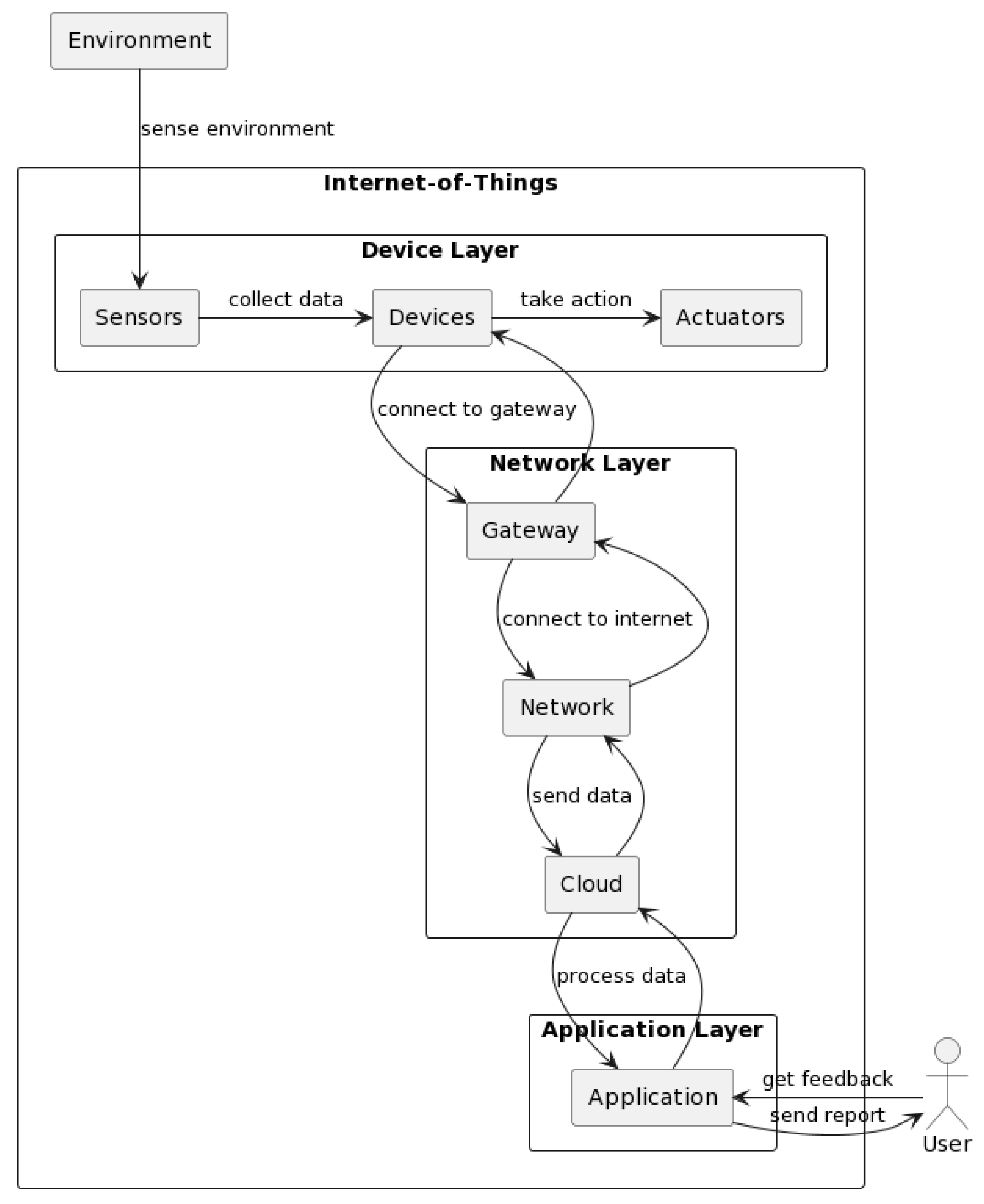
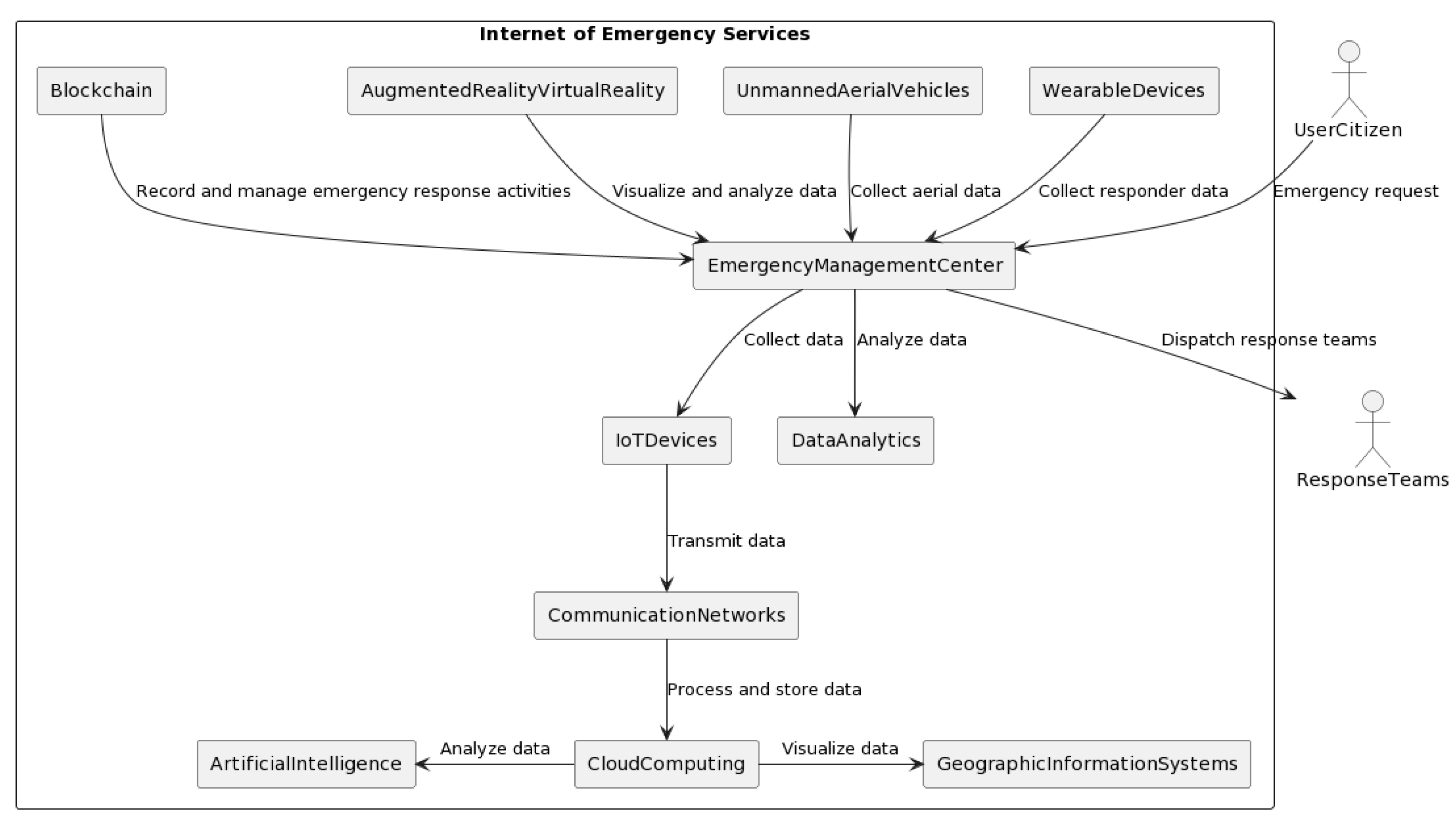
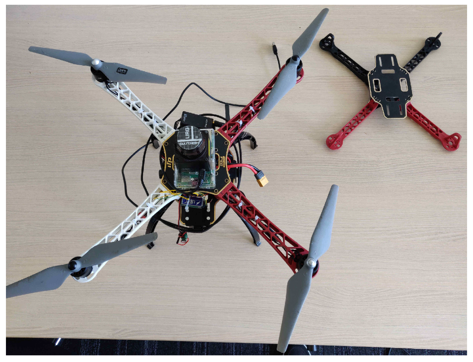
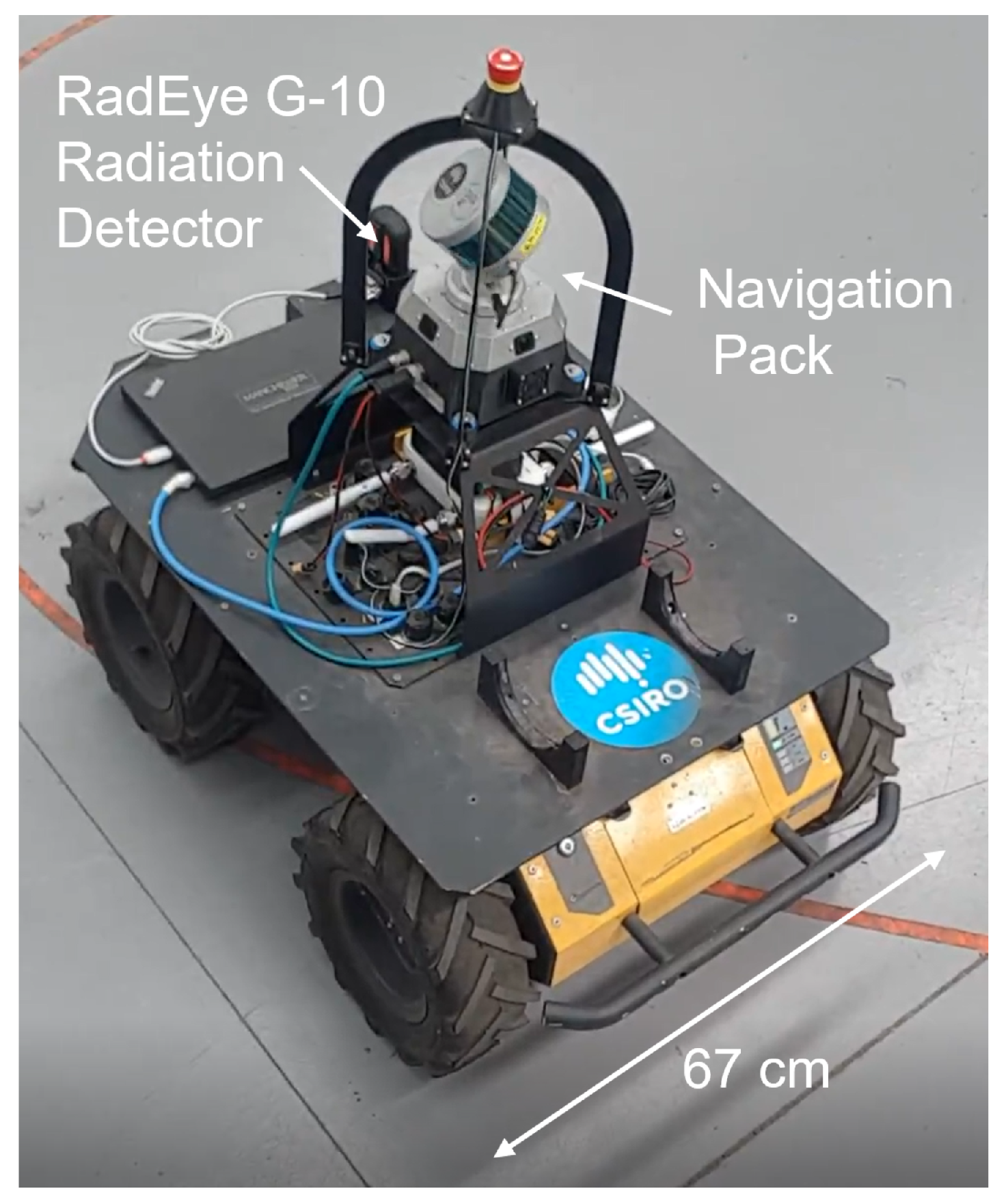
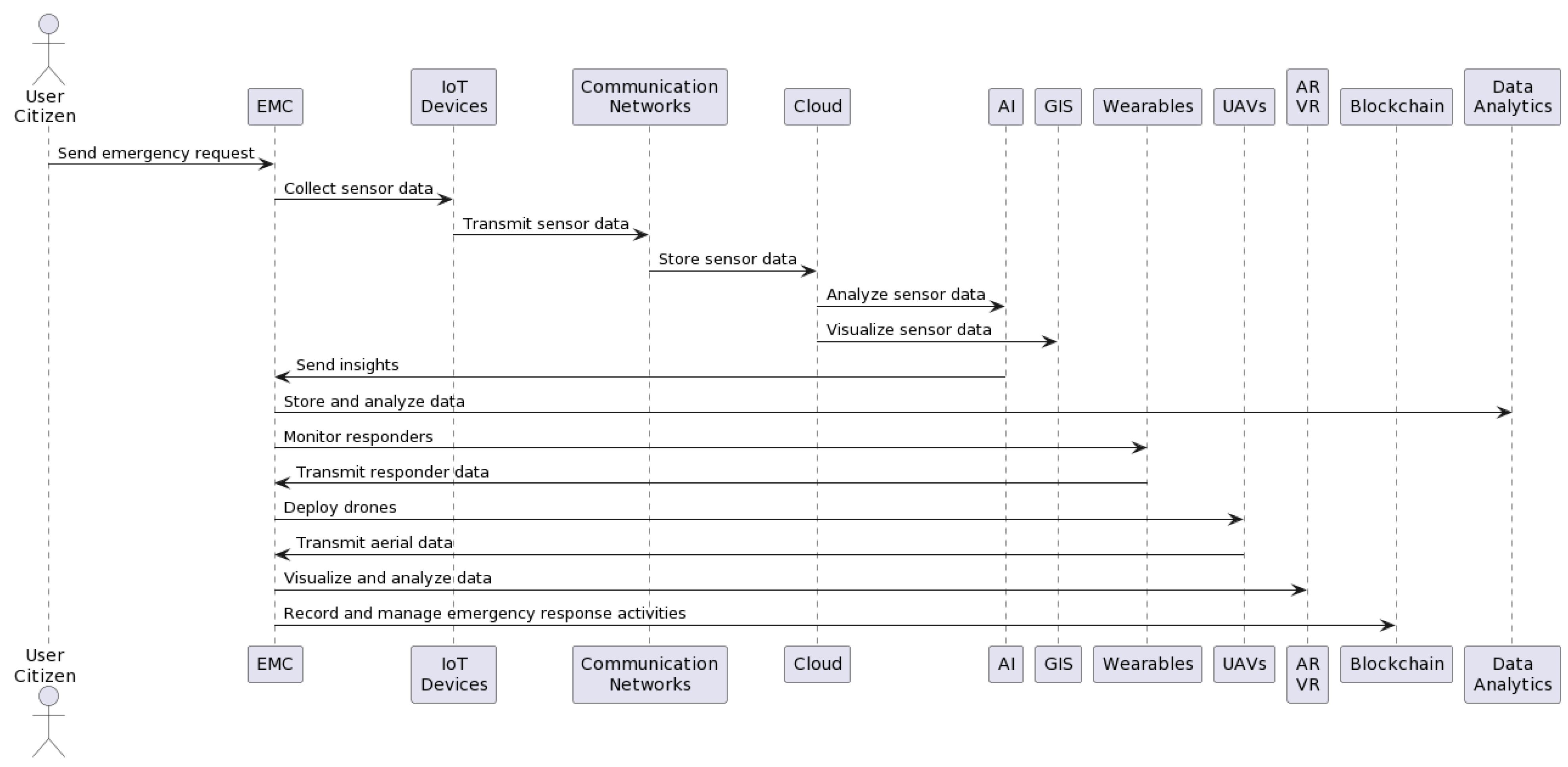
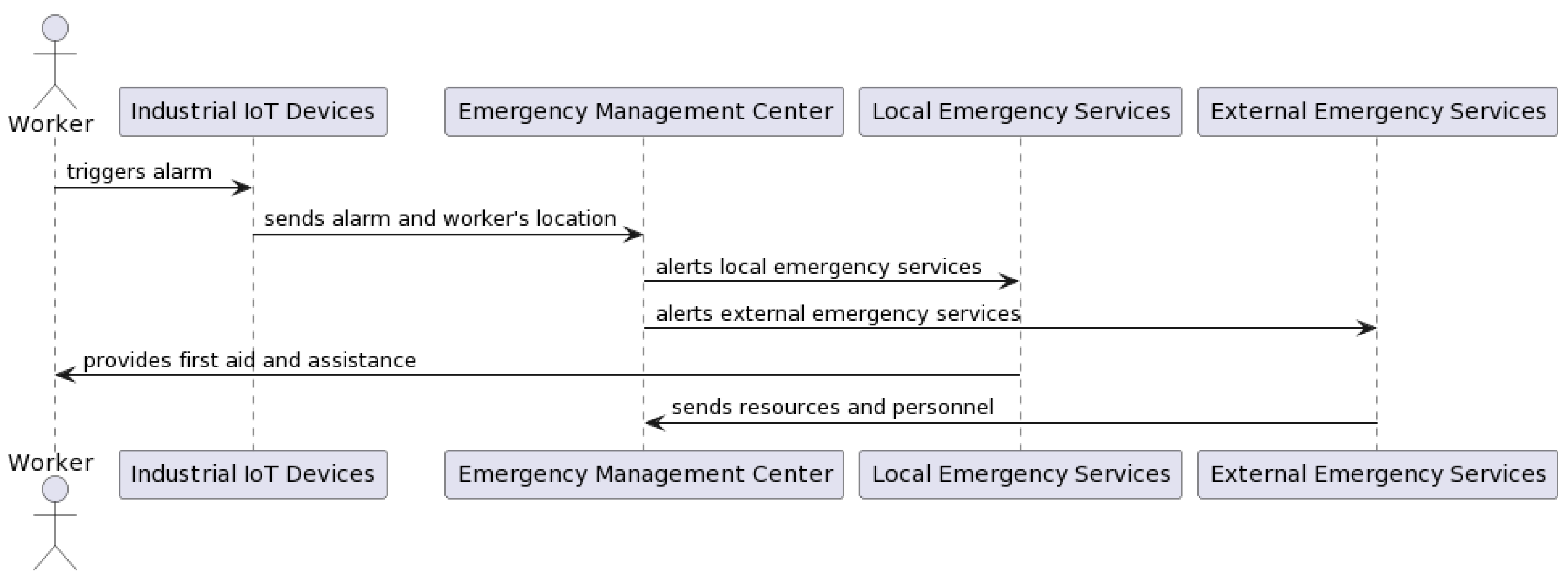


