
Crops on the Rocks: Production, Processing, and Storage at the Early Medieval Site of Senhora Do Barrocal (Municipality of Sátão, Central Portugal)

 ,
,
Abstract
1. Introduction
2. The Medieval Site
3. Materials and Methods
3.1. Sampling Strategy
3.2. Laboratory Analysis
3.2.1. Fruits/Seeds
3.2.2. Charcoal Analysis
3.2.3. Analysis of Food Remains
4. Results
4.1. Fruits/Seeds
4.2. Charcoal Analysis
4.3. Food Remains
5. Discussion
5.1. Storage
5.2. Crop Diversity
6. Conclusions
Supplementary Materials
Author Contributions
Funding
Institutional Review Board Statement
Informed Consent Statement
Data Availability Statement
Conflicts of Interest
References
- Barroca, M. Muçulmanos e Cristãos no Douro Português (Séc. VIII-XI). In Vindos de Longe. Estrangueiros No Douro, Proceedings of the 4as Conferencias do Museu de Lamego/CITCEM, Lamego, Portugal, 15 July 2016; Museu de Lamego—Direção Regional de Cultura do Norte: Lamego, Portugal, 2016; pp. 33–48. [Google Scholar]
- Tente, C. No smoke without fire. Burning and changing settlements in 10th-century central-northern Portugal. In Settlement Change across Medieval Europe. Old Paradigms and New Vistas, Proceedings of the Ruralia XII, Kilkenny, Ireland, 11–17 September 2017; Brady, N., Theune, C., Eds.; Sidestone Press: Leiden, The Netherlands, 2019; pp. 395–403. [Google Scholar]
- Maillo Salgado, F. Acerca de la Conquista Árabe de Hispania. Imprecisiones, Equívocos y Patrañas; ABADA: Madrid, Spain, 2016. [Google Scholar]
- Viso, I.M. Integración políticas y geografías del poder en el Noroeste de la Península Ibérica (siglos IX-X): El caso de Viseu. In Proceedings of the Conference Do Império ao Reino, Viseu e o Território Entre os Séculos IV a XII, Viseu, Portugal, 12–14 April 2016; Tente, C., Ed.; Câmara Municipal de Viseu: Viseu, Portugal, 2018; pp. 44–60. [Google Scholar]
- Tente, C. Viver Em Autarcia. A organização do território do Alto Mondego (Portugal) entre os séculos V a X. In ¿Tiempos Oscuros? Territorio y Sociedad en el Centro de la Península Ibérica (Siglos vi–x); Martín Viso, I., Ed.; Sílex: Salamanca, Spain, 2009; pp. 137–157. [Google Scholar]
- Tente, C. Social complexity in local communities during the tenth century in central-northern Portugal. In Social Inequality in Early Medieval Europe; Quirós Castilho, J.A., Ed.; Brepols: Turnhout, Belgium, 2020; pp. 149–163. [Google Scholar] [CrossRef]
- Oliveira Marques, A.H. Introdução à História da Agricultura em Portugal: A Questão Cerealífera Durante a Idade Média, 3rd ed.; Edições Cosmos: Lisboa, Portugal, 1978. [Google Scholar]
- Gonçalves, I. Por Terras de Entre-Douro-e-Minho Com as Inquirições de Afonso III; Edições Afrontamento/CITCEM: Porto, Portugal, 2012. [Google Scholar]
- Zapata, L.; Ruiz-Alonso, M. Agricultura altomedieval y usos forestales en Gasteiz (siglos VIII-XII dC). Datos carpológicos y antracológicos. In Arqueología e Historia de Una Ciudad: Los Orígenes de Vitoria-Gasteiz (I); Garai-Olaun, A.A., Solaun Bustinza, J.L., Eds.; Universidad del País Vasco, Servicio de Publicaciones: Vitoria, Spain, 2013; pp. 253–278. [Google Scholar]
- Alonso, N.; Antolín, F.; Kirchner, H. Novelties and legacies in crops of the Islamic period in the northeast Iberian Peninsula: The archaeobotanical evidence in Madîna Balagî, Madîna Lârida, and Madîna Turṭûša. Quat. Int. 2014, 346, 149–161. [Google Scholar] [CrossRef]
- McClatchie, M.; McCormick, F.; Kerr, T.R.; O’Sullivan, A. Early medieval farming and food production: A review of the archaeobotanical evidence from archaeological excavations in Ireland. Veget. Hist. Archaeobot. 2015, 24, 179–186. [Google Scholar] [CrossRef]
- Ruas, M.P. Aspects of early medieval farming from sites in Mediterranean France. Veget. Hist. Archaeobot. 2005, 14, 400–415. [Google Scholar] [CrossRef]
- Haneca, K.; Deforce, K. Wood use in early medieval weapon production. Archaeol. Anthropol. Sci. 2020, 12, 9. [Google Scholar] [CrossRef]
- Oliveira, C.; Jesus, A.; Tente, C.; Tereso, J.P. Estudo arqueobotânico do povoado alto-medieval de S. Gens: Perspetivas sobre a exploração de recursos lenhosos e agrícolas. In Arqueologia em Portugal/2017–Estado da Questão, Proceedings of the II Congresso da Associação dos Arqueólogos Portugueses, Lisboa, Portugal, 22–26 November 2017; Arnaud, J.M., Martins, A., Eds.; Associação dos Arqueólogos Portugueses: Lisboa, Portugal, 2017; pp. 1481–1494. [Google Scholar]
- Peña-Chocarro, L.; Pérez- Jordà, G.; Alonso, N.; Antolín, F.; Teira-Brión, A.; Tereso, J.P.; Montes Moya, E.M.; Reyes, D.L. Roman and medieval crops in the Iberian Peninsula: A first overview of seeds and fruits from archaeological sites. Quatern. Int. 2019, 499 Pt A, 49–66. [Google Scholar] [CrossRef]
- Bugalhão, J.; Queiroz, P. Testemunhos do consume de frutos no período islâmico em Lisboa. In Al-Ándalus Espaço de Mudança. Balanço de 25 Anos de História e Arqueologia Medievais: Homenagem a Juan Zozaya Stabel-Hansen; Gómez Martínez, S., Ed.; Campo Arqueológico de Mértola: Mértola, Portugal, 2005; pp. 195–212. [Google Scholar]
- Teira-Brión, A. Cultivos e froiteiras na Idade Media en Galicia. O conxunto carpolóxico da escavación do Banco de España (Santiago de Compostela). GALLÆCIA 2015, 34, 209–226. [Google Scholar]
- Coradeschi, G.; Mourer, A.-F.; Santos, J.; Lopes, G.; Vignola, C.; Sadori, L.; Dias, C. Investigação arqueobotânica dos sedimentos arqueológicos de Paço dos Lobos da Gama: Um arrabalde islâmico da cidade de Évora (séculos XI-XII). DigitAR 2017, 4, 33–40. [Google Scholar] [CrossRef]
- Queiroz, P. Estudo arqueobotânico no Povoado Medieval da Soida, Celorico da Beira. In Terra Scenica-Território Antigo Relatórios; Terra Scenica: Lisboa, Portugal, 2009; Technical Report 12. [Google Scholar]
- Queiroz, P.F.; Ruas, J.P. Estudos de Arqueobotânica no Penedo dos Mouros. In Trabalhos Do CIPA; CIPA-IPA: Lisboa, Portugal, 2001; Technical Report 13. [Google Scholar]
- Queiroz, P.; Leeuwaarden, W.V. Estudos de Arqueobotânica no Penedos dos Mouros/Gouveia—II. In Trabalhos Do CIPA; CIPA-IPA: Lisboa, Portugal, 2003; Technical Report 47. [Google Scholar]
- Queiroz, P. Novos dados arqueobotânicos sobre o Penedo dos Mouros (Gouveia). In Terra Scenica-Território Antigo Relatórios; Terra Scenica: Lisboa, Portugal, 2009; Technical Report 11. [Google Scholar]
- Queiroz, P. Estudo antracológico no sítio de S. Gens, Celorico da Beira. In Terra Scenica-Território Antigo Relatórios; Terra Scenica: Lisboa, Portugal, 2009; Technical Report 13. [Google Scholar]
- Queiroz, P.; Leeuwaarden, W.V. Estudos de Arqueobotânica no povoado medieval da Quinta da Torrinha, Góis. In Trabalhos do CIPA; CIPA-IPA: Lisboa, Portugal, 2004; Technical Report 58. [Google Scholar]
- Tereso, J.P.; Tente, C.; Baptista, H. O sítio da Senhora do Barrocal (Sátão, Viseu): Vestígios das práticas agrícolas e de exploração dos recursos agrários no século X. In Old and New Worlds: The Global Challenges of Rural History. In Proceedings of the V Encontro Rural RePort= XV Congresso de Historia Agraria de la SEHA, Lisboa, Portugal, 27–30 January 2016. [Google Scholar]
- Tente, C.; Baptista, H.; Tereso, J.P.; Cércio, M.; Veloso, J.L.; Oliveira, C.; Seabra, L.; Meira, C.; Souza, G.; Ruiz, T.C.; et al. Senhora do Barrocal (Sátão) na viragem do milénio Primeira abordagem. In Proceedings of the Conference Do Império ao Reino Viseu e o Território Entre os Séculos IV a XII, Viseu, Portugal, 12–14 April 2016; Tente, C., Ed.; Câmara Municipal de Viseu: Viseu, Portugal, 2018; pp. 263–295. [Google Scholar]
- Bronk Ramsey, C. Bayesian analysis of radiocarbon dates. Radiocarbon 2009, 51, 337–360. [Google Scholar] [CrossRef]
- Reimer, P.J.; Austin, W.E.N.; Bard, E.; Bayliss, A.; Blackwell, P.G.; Bronk Ramsey, C.; Butzin, M.; Cheng, H.; Edwards, R.L.; Friedrich, M.; et al. The IntCal20 Northern Hemisphere Radiocarbon Age Calibration Curve (0–55 cal kBP). Radiocarbon 2020, 62, 725–757. [Google Scholar] [CrossRef]
- Estefânio, A. A inscrição moçárabe do Barrocal. Beira Alta 2009, 68–69, 203–224. [Google Scholar]
- Tente, C.; Carvalho, A.F. The establishment of radiocarbon chronologies for early medieval sites: A case study from the upper Mondego Valley (Guarda, Portugal). Munibe 2011, 62, 461–468. [Google Scholar]
- Beijerinck, W. Zadenatlas der Nederlandsche Flora: Ten Behoeve van de Botanie, Palaeontologie, Bodemcultuur en Warenkennis, Omvattende, Naast de Inheemsche Flora, Onzc Belangrijkste Cultuurgewassen en Verschillende Adventiefsoorten; Wageningen 1967; Reprint Backhuis and Meesters; Mededeeling van het Biologische Instituut te Wijster 30: Amsterdam, The Netherlands, 1976. [Google Scholar]
- Castroviejo, S. Flora Iberica 1–8, 10–15, 17–18, 21; Real Jardín Botánico, CSIC: Madrid, Spain, 1986–2012; Available online: http://www.floraiberica.org/ (accessed on 1 December 2021).
- Hillman, G.; Mason, S.; de Moulins, D.; Nesbitt, M. Identification of archaeological remains of wheat: The 1992 London workshop. Circaea 1996, 12, 195–210. [Google Scholar]
- Buxó, R. Arqueología de las Plantas. La Explotación Económica de las Semillas y los Frutos en el Marco Mediterráneo de Península Ibérica; Crítica: Barcelona, Spain, 1997. [Google Scholar]
- Jacomet, S. Identification of Cereal Remains from Archaeological Sites, 2nd ed.; Archaeobotany Lab, IPAS, Basel University: Basel, Switzerland, 2006. [Google Scholar]
- Nesbitt, M. Identification Guide for Near Eastern Grass Seeds, 1st ed.; Routledge: London, UK, 2006. [Google Scholar] [CrossRef]
- Neef, R.; Cappers, R.T.J.; Bekker, R.M. Digital Atlas of Economic Plants in Archaeology, Groningen Archaeological Studies, 17; Barkhuis Publishing & Groningen University Library: Groningen, The Netherlands, 2012. [Google Scholar]
- Zohary, D.; Hopf, M.; Weiss, E. Domestication of Plants in the Old World: The Origin and Spread of Domesticated Plants in Southwest Asia, Europe, and the Mediterranean Basin; Oxford University Press: Oxford, UK, 2012. [Google Scholar]
- International Plant Name Index (IPNI). Available online: https://www.ipni.org (accessed on 20 January 2022).
- van Zeist, W.A. Prehistoric and early historic food plants in the Netherlands. Palaeohistoria 1968, 14, 42–173. [Google Scholar]
- Pasternak, R. Hafer aus dem mittelalterlichen Schleswig. Offa 1991, 48, 363–380. [Google Scholar]
- Ruas, M.P.; Pradat, B. Les semences découvertes: Plantes attestées et origine des déchets. In Les Habitats Carolingiens de Montours et La Chapelle Saint-Aubert (Ille-et-Vilaine); Catteddu, I., Ed.; Documents D’archéologie Française 89; Éditions de la Maison des Sciences de L´Homme: Paris, France, 2001; pp. 65–79+219–221. [Google Scholar]
- Schweingruber, F.H. Anatomy of European Woods; Paul Haupt: Bern, Switzerland, 1990. [Google Scholar]
- Hather, J.G. The Identification of the Northern European Woods. A Guide Archaeologists and Conservators; Archetype Publications: London, UK, 2000. [Google Scholar]
- Queiroz, P.; van der Burgh, J. Wood anatomy of Iberian Ericales. Rev. Biol. 1989, 14, 95–134. [Google Scholar]
- Tereso, J.P. Paleoetnobotanica do Povoado Romano da Terronha do Pinhovelo (NE Transmontano). Master’s Thesis, Universidade do Porto, Porto, Portugal, 2007. [Google Scholar]
- Marguerie, D.; Hunot, J.-Y. Charcoal analysis and dendrology: Data from archaeological sites in northwestern France. J. Archaeol. Sci. 2007, 34, 1417–1433. [Google Scholar] [CrossRef]
- McParland, L.C.; Collinson, M.E.; Scott, A.C.; Campbell, G.; Veal, R. Is vitrification in charcoal a result of high temperature burning of wood? J. Archaeol. Sci. 2010, 37, 2679–2687. [Google Scholar] [CrossRef]
- Théry-Parisot, I.; Henry, A. Seasoned or green? Radial cracks analysis as a method for identifying the use of green wood as fuel in archaeological charcoal. J. Archaeol. Sci. 2012, 39, 381–388. [Google Scholar] [CrossRef]
- Moskal-del Hoyo, M.; Wachowiak, M.; Blanchette, R.A. Preservation of fungi in archaeological charcoal. J. Archaeol. Sci. 2010, 37, 2106–2116. [Google Scholar] [CrossRef]
- Heiss, A.G.; Pouget, N.; Wiethold, J.; Delor-Ahü, A.; Le Goff, I. Tissue-based analysis of a charred flat bread (galette) from a Roman cemetery at Saint-Memmie (Dép. Marne, Champagne-Ardenne, north-eastern France). J. Archaeol. Sci. 2015, 55, 71–82. [Google Scholar] [CrossRef]
- Heiss, A.G.; Antolín, F.; Bleicher, N.; Harb, C.; Jacomet, S.; Kühn, M.; Marinova, E.; Stika, H.-P.; Valamoti, S.M. State of the (t)art. Analytical approaches in the investigation of components and production traits of archaeological bread-like objects, applied to two finds from the Neolithic lakeshore settlement Parkhaus Opéra (Zürich, Switzerland). PLoS ONE 2017, 12, e0182401. [Google Scholar] [CrossRef] [PubMed]
- González Carretero, L.; Wollstonecroft, M.; Fuller, D.Q. A methodological approach to the study of archaeological cereal meals: A case study at Çatalhöyük East (Turkey). Veget. Hist. Archaeobot. 2017, 26, 415–432. [Google Scholar] [CrossRef] [PubMed]
- González Carretero, L. On the Origins of Bread Cultures in the Near East: A New Archaeobotanical Study of Charred Meals and Cooking Practices from Neolithic Çatalhöyük (Turkey) and Jarmo (Iraqi Kurdistan). Ph.D. Thesis, University College London, London, UK, 2020. [Google Scholar]
- Aguiar, C. Flora e Vegetação da Serra de Nogueira e do Parque Natural de Montesinho. Ph.D. Thesis, Universidade Técnica de Lisboa, Lisboa, Portugal, 2000. [Google Scholar]
- Winton, A.L.; Winton, K.B. The Structure and Composition of Foods; Wiley: New York, NY, USA, 1932. [Google Scholar]
- Holden, T. Transverse cell patterns of wheat and rye bran and their variation over the surface of a single grain. Circaea 1990, 6, 97–104. [Google Scholar]
- College, S. Scanning Electron Studies of the Cell Patterns of the pericarp layers of some wild wheats and ryes. Methods and problems. In Scanning Electron Microscopy in Archaeology; Olsen, S.L., Ed.; British Archaeological Reports International Series 452; Archaeopress: Oxford, UK, 1988; pp. 225–226. [Google Scholar]
- Butler, A. Legumes in Antiquity. A Micromorphological Investigation of Seeds of the Vicieae. Ph.D. Thesis, University College London, London, UK, 1990. [Google Scholar]
- Alonso, N. Agriculture and food from the Roman to the Islamic Period in the North-East of the Iberian peninsula: Archaeobotanical studies in the city of Lleida (Catalonia, Spain). Veget. Hist. Archaeobot. 2005, 14, 341–361. [Google Scholar] [CrossRef]
- Teira-Brión, A.; Domínguez, A.C.; Portillo, M.; Albert, R.M.; Mato, M.P. La excavación arqueológica de los Grandes Almacenes El Pilar (Santiago de Compostela, Galicia, España): Un estudio arqueobotánico de silos de almacenaje medievales. Estud. Quat./Quat. Stud. 2010, 6, 75–90. [Google Scholar] [CrossRef]
- Quirós Castillo, J.A. Silos y sistemas de almacenaje en el País Vasco en la Alta Edad Media. In Horrea, Barns and Silos. Storage and Incomes in Early Medieval Europe; Guirado, A.V.-E., Bianchi, G., Quirós Castillo, J.A., Eds.; Servicio Editorial de la UPV/EHU: Bilbao, Spain, 2013; pp. 171–192. [Google Scholar]
- Resino, A.R. Sistemas subterráneos de almacenamiento en la Galicia medieval. Una primera tipología y consideraciones para su estudio. In Horrea, Barns and Silos. Storage and Incomes in Early Medieval Europe; Guirado, A.V.-E., Bianchi, G., Quirós Castillo, J.A., Eds.; Servicio Editorial de la UPV/EHU: Bilbao, Spain, 2013; pp. 193–208. [Google Scholar]
- Quirós Castillo, J.A.; Nicosia, C.; Polo-Díaz, A.; del Árbol, M.R. Agrarian archaeology in northern Iberia: Geoarchaeology and early medieval land use. Quat. Int. 2014, 346, 56–68. [Google Scholar] [CrossRef]
- Vigil-Escalera Guirado, A.; Moreno-García, M.; Peña-Chocarro, L.; Morales Muñiz, A.; Llorente Rodríguez, L.; Sabato, D.; Ucchesu, M. Productive strategies and consumption patterns in the Early Medieval village of Gózquez (Madrid, Spain). Quat. Int. 2014, 346, 7–19. [Google Scholar] [CrossRef]
- Pérez-Díaz, S.; Ruiz-Alonso, M.; López-Sáez, J.A.; Solaun-Bustinza, J.L.; Azkarate, A.; Zapata, L. A palaeoenvironmental and palaeoeconomic approach to the Early Middle Age record from the village of Gasteiz (Basque Country, Northern Iberian Peninsula). Veget. Hist. Archaeobot. 2015, 24, 683–697. [Google Scholar] [CrossRef]
- Hillman, G. Reconstructing crop husbandry practices from charred remains of crops. In Farming Practice in Prehistoric Britain; Mercer, R., Ed.; Edinburgh University Press: Edinburgh, UK, 1981; pp. 123–162. [Google Scholar]
- Boardman, S.; Jones, G. Experiments on the effects of charring on cereal plant components. J. Archaeol. Sci. 1990, 17, 1–11. [Google Scholar] [CrossRef]
- Van der Veen, M. Formation processes of desiccated and carbonized plant remains e the identification of routine practice. J. Archaeol. Sci. 2007, 34, 968–990. [Google Scholar] [CrossRef]
- Hillman, G. Traditional husbandry and processing of archaic cereals in recent times: The operations, products and equipment which might feature in Sumerian texts. Part I: The glume wheats. Bull. Sumerian Agric. 1984, 1, 114–152. [Google Scholar]
- Peña-Chocarro, L. Prehistoric Agriculture in Southern Spain during the Neolithic and the Bronze Age. The Application of Ethnographic Models; British Archaeological Reports International Series 818; Archaeopress: Oxford, UK, 1999. [Google Scholar]
- Alonso, N. A first approach to women, tools and operation sequences in traditional manual cereal grinding. Archaeol. Anthropol. Sci. 2019, 11, 4307–4324. [Google Scholar] [CrossRef]
- Ruas, M.P. Un témoignage de pratiques agro-pastorales au XIe-XIIe siècle en Bas-Limousin. Les grains brûlés dans un silo à Chadalais (Haute-Vienne, Limousin). In Carpologia: Articles réunis à la mémoire de Karen Lundström-Baudais, Proceedings of the Rencontres D’archéobotanique, Glux-en-Glenne, France, 9–12 June 2005; Wiethold, J., Ed.; Bibracte, 20; Bibracte—Centre Archéologique Européen: Glux-en-Glenne, France, 2011; pp. 137–254. [Google Scholar]
- Hallam, H.E. Rural England 1066–1348; The Harvester Press: Sussex, UK, 1981. [Google Scholar]
- El Viejo, P. Historia Natural; Translated by Francisco Hernández (Books 1–25) and Jerónimo de Huerta (Books 26–37); Visor Libros, Universidad Nacional de México: Mexico City, Mexico, 1999. [Google Scholar]
- Moreno-Larrazabal, A.; Teira-Brión, A.; Sopelana-Salcedo, I.; Arranz-Otaegui, A.; Zapata, L. Ethnobotany of millet cultivation in the north of the Iberian Peninsula. Veget. Hist. Archaeobot. 2015, 24, 1–14. [Google Scholar] [CrossRef]
- Quirós Castillo, J.A.; Tereso, J.P.; Seabra, L. Social history of agriculture at medieval rural sites in the northern of the Iberia Peninsula: Aistra and Zornoztegi (Alava, Spain). J. Archaeol. Sci. Rep. 2020, 33, 102442. [Google Scholar] [CrossRef]
- Fuller, D.; Stevens, C.; McClatchie, M. Routine activities, tertiary refuse, and labor organization: Social inferences from everyday archaeobotany. In Ancient Plants and People: Contemporary Trends in Archaeobotany; Madella, M., Lancelotti, C., Savard, M., Eds.; University of Arizona Press: Tucson, AR, USA, 2014; pp. 174–217. [Google Scholar]
- Jones, G. Distinguishing Food from Fodder in the Archaeobotanical Record. Environ. Archaeol. 1998, 1, 95–98. [Google Scholar] [CrossRef]
- Autio, K.; Laurikainen, T. Relationships between flour/dough microstructure and dough handling and baking properties. Trends Food Sci. Technol. 1997, 6, 181–185. [Google Scholar] [CrossRef]
- Ruas, M.P.; Bouby, L.; Py, V.; Cazes, J.-P. An 11th century a.d. burnt granary at La Gravette, south-western France: Preliminary archaeobotanical results. Veget. Hist. Archaeobot 2005, 14, 416–426. [Google Scholar] [CrossRef]
- di Lernia, S.; N´Siala, M.I.; Mercuri, A.M. Saharan prehistoric basketry. Archaeological and archaeobotanical analysis of the early-middle Holocene assemblage from Takarkori (Acacus Mts., SW Libya). J. Archaeol. Sci. 2012, 39, 1837–1853. [Google Scholar] [CrossRef]
- Morales, J.; Mulazzani, S.; Belhouchet, L.; Zazzo, A.; Berrio, L.; Eddargach, W.; Cervi, A.; Hamdi, H.; Saidi, M.; Coppa, A.; et al. First preliminary evidence for basketry and nut consumption in the Capsian culture (ca. 10,000–7500 BP): Archaeobotanical data from new excavations at El Mekta, Tunisia. J. Anthropol. Archaeol. 2015, 37, 128–139. [Google Scholar] [CrossRef]
- Filipović, D.; Đurđa, O.; Tripković, B. Plant storage in Neolithic southeast Europe: Synthesis of the archaeological and archaeobotanical evidence from Serbia. Veget. Hist. Archaeobot. 2018, 27, 31–44. [Google Scholar] [CrossRef]
- Peña-Chocarro, L.; Castiglioni, E.; Rettore, E. Agricultura y alimentación en época medieval en cantón Ticino (Suiza): El yacimiento de Tremona. In Condicions de Vida al Món Rural, Proceedings of the V Congrés Sobre Sistemas Agraris, Organització Social i Poder Local, Lleida, Spain, 15 April 2005; Bolòs, J., Jarne, A., Vicedo, E., Eds.; Institut d’Estudis Ilerdencs: Lleida, Spain, 2006; pp. 741–754. [Google Scholar]
- Grabowski, R. Changes in cereal cultivation during the Iron Age in southern Sweden: A compilation and interpretation of the archaeobotanical material. Veget. Hist. Archaeobot. 2011, 20, 479–494. [Google Scholar] [CrossRef]
- Díaz García, A. La alimentación en el reino nazarí a la luz de un tratado sobre alimentos de la época. In Proceedings of the II Jornadas de Cultura Árabe e Islámica; Instituto Hispano-Arabe de Cultura: Madrid, Spain, 1985; pp. 177–184. [Google Scholar]
- García Sánchez, E. Aspectos dietéticos de la alimentación en Al-Andalus. In Historia y Cultura del Islam Español (Curso de Conferencias 1986-87); Escuela de Estudios Arabes, C.S.I.C.: Granada, Spain, 1988; pp. 43–65. [Google Scholar]
- Gutiérrez Lloret, S. La producción de pan y aceite en ambientes domésticos: Límites y posibilidades de una aproximación etnoarqueológica. Arqueol. Mediev. 1996, 4, 237–254. [Google Scholar]
- Gutiérrez Lloret, S. Panes, hogazas y fogones portátiles. Dos formas cerámicas destinadas a la cocción del pan en Al-Andalus: El hornillo (Tannur) y el plato (Tabag). Lvcentvm 1989, IX–X, 161–175. [Google Scholar] [CrossRef]
- Tereso, J.P. Environmental Change, Agricultural Development and Social Trends in NW Iberia from the Late Prehistory to the Late Antiquity. Ph.D. Thesis, Universidade do Porto, Porto, Portugal, 2012. [Google Scholar]
- Behre, K.E. The history of rye cultivation in Europe. Veget. Hist. Archaeobot. 1992, 1, 141–156. [Google Scholar] [CrossRef]
- Tereso, J.P.; Vaz, F.C.; Seabra, L.; Cosme, S.; Pereira, S. Os níveis medievais do sítio de Quinta de Crestelos (Mogadouro): Agricultura e paisagem. Arqueol. Mediev. 2016, 14, 101–118. [Google Scholar]
- Tente, C.; Prata, S.; Cuesta-Gómez, F.; Brookes, S.; Moreno-Gárcía, M.; De Souza, G.; Tereso, J.P.; Oliveira, C.; Jesus, A. Povoamento e modos de vida no limite oriental do território viseense durante o século X. O Povoado de S. Gens. In Proceedings of the Conference Do Império ao Reino, Viseu e o Território Entre os Séculos IV a XII, Viseu, Portugal, 12–14 April 2016; Tente, C., Ed.; Câmara Municipal de Viseu: Viseu, Portugal, 2018; pp. 197–228. [Google Scholar]
- Tereso, J.P.; Vilaça, R.; Osório, M.; da Fonte, L.; Seabra, L. Destroyed by fire, preserved through time: Crops and wood from a Late Bronze Age/Early Iron Age structure at Vila do Touro (Sabugal, Portugal). Complutum 2020, 31, 255–278. [Google Scholar] [CrossRef]
- van der Knaap, W.O.; van Leeuwen, J.F.N. Holocene vegetation succession and degradation as responses to climatic change and human activity in the Serra de Estrela, Portugal. Rev. Palaeobot. Palynol. 1995, 89, 153–211. [Google Scholar] [CrossRef]
- Tereso, J.P.; Pereira, S.; Santos, F.; Seabra, L.; Vaz, F.C. Cultivos de época romana no Baixo Sabor: Continuidade em tempos de mudança? In Arqueologia em Portugal/2020–Estado da Questão, Proceedings of the III Congresso da Associação dos Arqueólogos Portugueses, Lisboa, Portugal, 19–22 November 2020; Arnaud, J.M., Neves, C., Martins, A., Eds.; Associação dos Arqueólogos Portugueses: Lisboa, Portugal, 2020; pp. 1207–1220. [Google Scholar] [CrossRef]


| S.U. | Description | Context | Material | Lab. Reference | 14C Age (yr B.P.) | Calibrated Age A.D. (2 σ) |
|---|---|---|---|---|---|---|
| 107 | Destruction layer | Habitation structure 09 | Vicia faba (seed) | Wk-40079 | 1040 ± 21 | 987–1032 (95.4%) |
| 125 | Filling layer | Debris within Wall 112 | Secale cereale (grain) | Beta-46513 | 1170 ± 30 | 772–901 (73.9%) 916–974 (21.6%) |
| 132 | Clay layer | Hearth 2 | Erica arborea (charcoal) | Beta-46512 | 1070 ± 30 | 893–929 (23.6%) 944–1026 (71.8%) |
| Collected | Studied | ||||||||||
|---|---|---|---|---|---|---|---|---|---|---|---|
| Phase 1 | 278 | 198 | Moment | Collected | Studied | No. of S.U. | No. of Squares | ||||
| 1st | 15 | Handpicked | 15 | 15 | Handpicked | 15 | 2 | 8 | |||
| 2nd | 263 | Handpicked | 155 | 183 | Handpicked | 155 | 6 | 49 | |||
| Sediment | 108 | Sediment | 28 | ||||||||
| Phase 2 | 268 | 241 | 3rd | 7 | Handpicked | 1 | 7 | Handpicked | 1 | 3 | 4 |
| Sediment | 6 | Sediment | 6 | ||||||||
| 4th | 125 | Handpicked | 81 | 99 | Handpicked | 81 | 8 | 24 | |||
| Sediment | 44 | Sediment | 18 | ||||||||
| 5th | 8 | Handpicked | 4 | 7 | Handpicked | 4 | 3 | 5 | |||
| Sediment | 4 | Sediment | 3 | ||||||||
| 6th | 128 | Handpicked | 120 | 128 | Handpicked | 120 | 8 | 64 | |||
| Sediment | 8 | Sediment | 8 | ||||||||
| Occupation | Phase 1 | Phase 2 | ||||||||||||||||||||||
| Moment | 1st | 2nd | 3rd | 4th | 5th | 6th | ||||||||||||||||||
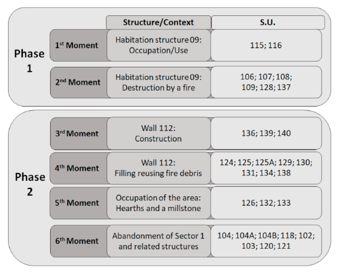
| Structure | HS9 | HS9 | W112 | W112 | H1 | H2 | GM | W112 | SS123 | PHS | ||||||||||||||
| S.U. | 115 | 116 | 106 | 107 | 108 | 109 | 137 | 136 | 139 | 140 | 124 | 125 | 130 | 131 | 134 | 126 | 132 | 133 | 104 | 104A | 104B | 118 | 102 | 121 |
| Cereal (grain) | ||||||||||||||||||||||||
| Avena sp. | 42 | 1 | 9 | 36,609 | 16 | 130 | 946 | 833 | 215 | 165 | 5166 | 3948 | 309 | 1 | 20 | 1 | 1 | 1050 | 1076 | 143 | 143 | 1 | ||
| Hordeum vulgare | 22 | 2 | 48 | 7248 | 9 | 5 | 13 | 99 | 17 | 43 | 666 | 506 | 40 | 9 | 5 | 324 | 221 | 284 | 134 | |||||
| Panicum miliaceum | 8 | 8345 | 44 | 299 | 210 | 60 | 71 | 978 | 487 | 74 | 11 | 7 | 2 | 1490 | 128 | 3 | 20 | |||||||
| Setaria italica | 123 | 6 | 4 | 19 | 6 | |||||||||||||||||||
| Setaria sp. | 9 | |||||||||||||||||||||||
| Panicoideae | 1128 | 17 | 30 | 29 | 299 | 171 | 29 | 2 | 1 | 179 | 42 | 2 | 5 | |||||||||||
| Secale cereale | 84 | 6 | 204 | 34,204 | 25 | 61 | 776 | 649 | 136 | 130 | 4471 | 3679 | 436 | 1 | 10 | 4 | 1 | 1989 | 439 | 565 | 1 | 362 | 4 | |
| Triticum aestivum/durum | 12 | 1 | 27 | 965 | 6 | 4 | 22 | 25 | 6 | 9 | 498 | 38 | 107 | 2 | 1 | 67 | 21 | 26 | 1 | 14 | 3 | |||
| Triticum sp. | 4 | 5 | ||||||||||||||||||||||
| Triticeae | 2 | 3 | 10,424 | 18 | 234 | 210 | 44 | 233 | 1338 | 1346 | 132 | 8 | 2 | 745 | 416 | 58 | 1 | 91 | 1 | |||||
| Cereal (chaff) | ||||||||||||||||||||||||
| Avena sativa/strigosa (floret base) | 842 | 11 | 10 | 40 | 4 | 127 | 173 | 25 | 54 | 10 | 2 | |||||||||||||
| Hordeum vulgare (lemma base) | 689 | 31 | 3 | 96 | 2 | 19 | 17 | 4 | ||||||||||||||||
| Hordeum vulgare (rachis segment with 1 node) | 48 | 4 | ||||||||||||||||||||||
| Panicum miliaceum (lemma/palea) | 32 | 8 | ||||||||||||||||||||||
| Setaria italica (lemma/palea) | 3 | 2 | ||||||||||||||||||||||
| Secale cereale (rachis segment with 1 node) | 741 | 131 | 48 | 13 | 19 | 213 | 406 | 5 | 2 | 1 | 16 | 76 | 1 | 1 | ||||||||||
| Secale cereale (rachis segment with 2 nodes) | 18 | 19 | 2 | |||||||||||||||||||||
| Triticum aestivum/durum (rachis node) | 122 | 4 | ||||||||||||||||||||||
| Fabaceae | ||||||||||||||||||||||||
| Lathyrus cicera/sativus (seed) | 71 | 1 | 2 | 14 | 1 | |||||||||||||||||||
| Lens culinaris (seed) | 18 | 1 | ||||||||||||||||||||||
| Pisum sativum (seed) | 1 | 1 | 412 | 1 | 8 | 2 | 1 | 3 | 2 | |||||||||||||||
| Vicia faba (seed) | 10 | 1 | 238 | 1 | 18 | 1 | 1 | 7 | 9 | |||||||||||||||
| Vicia/Lathyrus (seed) | 1 | 250 | 8 | 9 | 39 | 4 | 2 | 12 | 4 | 2 | 1 | |||||||||||||
| Vicia/Lathyrus/Pisum (seed) | 1 | 272 | 1 | 1 | 1 | 58 | 4 | 8 | 1 | 4 | 1 | 3 | ||||||||||||
| Fruits | ||||||||||||||||||||||||
| Castanea sativa (fruit) | 2 | |||||||||||||||||||||||
| Prunus avium/cerasus (endocarp) | 2 | 1 | ||||||||||||||||||||||
| Vitis vinifera (seed) | 1 | 101 | 24 | 8 | 4 | 1 | ||||||||||||||||||
| Vitis vinifera (pedicel) | 7 | 7 | 3 | 17 | 1 | |||||||||||||||||||
| Vitis vinifera (drupe with seed) | 2 | |||||||||||||||||||||||
| Oil/Fiber plants | ||||||||||||||||||||||||
| Linum sp. (seeds agglomerated) | 6 | |||||||||||||||||||||||
| Phase | 1 | 2 | ||||||||||||||||||||||||||||||||
| Moment | 1st | 2nd | Total | 3rd | 4th | 5th | 6th | Total | ||||||||||||||||||||||||||
| S.U. | 115 | 116 | 106 | 107 | 108 | 109 | 128 | 137 | N | % | 136 | 139 | 140 | 124 | 125 | 125A | 129 | 130 | 131 | 134 | 138 | 126 | 132 | 133 | 102 | 103 | 104 | 118 | 120 | 121 | 104A | 104B | N | % |
| Acer sp. | 2 | 2 | 0.02 | 1 | 1 | 0.01 | ||||||||||||||||||||||||||||
| Alnus sp. | 67 | 67 | 0.68 | 1 | 36 | 10 | 1 | 2 | 2 | 52 | 0.59 | |||||||||||||||||||||||
| Arbutus unedo | 4 | 56 | 460 | 58 | 15 | 593 | 6.03 | 55 | 18 | 6 | 105 | 11 | 2 | 13 | 2 | 16 | 13 | 32 | 20 | 27 | 2 | 2 | 32 | 23 | 12 | 391 | 4.46 | |||||||
| Castanea sativa | 15 | 60 | 25 | 2893 | 195 | 119 | 4 | 55 | 3366 | 34.22 | 228 | 109 | 33 | 62 | 1173 | 4 | 154 | 163 | 133 | 1 | 19 | 13 | 112 | 15 | 60 | 78 | 40 | 163 | 445 | 134 | 3139 | 35.81 | ||
| Castanea/Quercus | 4 | 18 | 27 | 1017 | 51 | 6 | 1123 | 11.42 | 29 | 194 | 2 | 14 | 13 | 20 | 22 | 103 | 13 | 11 | 9 | 5 | 66 | 73 | 20 | 594 | 6.78 | |||||||||
| Cistus sp. | 1 | 22 | 8 | 31 | 0.32 | 17 | 27 | 17 | 4 | 5 | 2 | 3 | 31 | 1 | 107 | 1.22 | ||||||||||||||||||
| Erica australis/arborea | 5 | 21 | 27 | 409 | 105 | 10 | 577 | 5.87 | 19 | 1 | 7 | 98 | 4 | 1 | 13 | 6 | 26 | 20 | 75 | 8 | 15 | 30 | 3 | 51 | 46 | 9 | 432 | 4.93 | ||||||
| Erica scoparia/umbellata | 2 | 25 | 27 | 0.27 | 2 | 6 | 2 | 5 | 1 | 1 | 17 | 0.19 | ||||||||||||||||||||||
| Erica sp. | 5 | 19 | 329 | 46 | 3 | 12 | 414 | 4.21 | 17 | 10 | 3 | 49 | 20 | 2 | 23 | 19 | 5 | 43 | 4 | 5 | 3 | 28 | 33 | 6 | 270 | 3.08 | ||||||||
| Fabaceae | 3 | 2 | 126 | 20 | 1 | 152 | 1.55 | 9 | 1 | 5 | 56 | 17 | 3 | 2 | 5 | 2 | 52 | 3 | 18 | 2 | 1 | 4 | 11 | 2 | 193 | 2.20 | ||||||||
| Frangula alnus | 2 | 2 | 0.02 | |||||||||||||||||||||||||||||||
| Fraxinus sp. | 1 | 14 | 4 | 19 | 0.19 | 1 | 1 | 1 | 12 | 2 | 1 | 2 | 4 | 2 | 26 | 0.30 | ||||||||||||||||||
| Olea europaea | 1 | 1 | 0.01 | |||||||||||||||||||||||||||||||
| Pistacia sp. | 3 | 3 | 0.03 | |||||||||||||||||||||||||||||||
| Pinus sp. | 1 | 1 | 0.01 | |||||||||||||||||||||||||||||||
| Prunus avium/cerasus | 44 | 44 | 0.45 | 3 | 22 | 8 | 2 | 5 | 3 | 9 | 20 | 5 | 77 | 0.88 | ||||||||||||||||||||
| Prunus sp. | 12 | 53 | 1 | 163 | 120 | 15 | 1 | 365 | 3.71 | 3 | 16 | 23 | 64 | 1 | 2 | 1 | 70 | 7 | 42 | 8 | 60 | 42 | 18 | 357 | 4.07 | |||||||||
| Quercus sp. | 1 | 3 | 11 | 148 | 2 | 165 | 1.68 | 4 | 24 | 1 | 1 | 3 | 6 | 8 | 5 | 1 | 16 | 6 | 75 | 0.86 | ||||||||||||||
| Quercus sp. deciduous | 8 | 29 | 192 | 1145 | 133 | 26 | 1 | 48 | 1582 | 16.08 | 167 | 93 | 51 | 15 | 297 | 53 | 2 | 56 | 1 | 36 | 2 | 35 | 7 | 6 | 286 | 55 | 111 | 135 | 44 | 308 | 208 | 20 | 1988 | 22.68 |
| Quercus sp. evergreen | 3 | 10 | 100 | 15 | 1 | 3 | 132 | 1.34 | 3 | 2 | 8 | 2 | 1 | 7 | 2 | 2 | 2 | 10 | 4 | 7 | 50 | 0.57 | ||||||||||||
| Rhamnus/Phillyrea | 1 | 3 | 3 | 7 | 0.07 | 2 | 2 | 1 | 1 | 1 | 1 | 8 | 0.09 | |||||||||||||||||||||
| Rosaceae Maloideae | 7 | 7 | 0.07 | 2 | 1 | 3 | 6 | 0.07 | ||||||||||||||||||||||||||
| Salix sp. | 2 | 6 | 8 | 0.08 | 1 | 1 | 2 | 4 | 0.05 | |||||||||||||||||||||||||
| Salix/Populus | 1 | 1 | 0.01 | |||||||||||||||||||||||||||||||
| Taxus baccata | 52 | 52 | 0.53 | 1 | 2 | 12 | 15 | 0.17 | ||||||||||||||||||||||||||
| Undetermined | 2 | 30 | 32 | 0.33 | 3 | 4 | 1 | 3 | 2 | 2 | 15 | 0.17 | ||||||||||||||||||||||
| Dicotyledon | 1 | 23 | 54 | 852 | 88 | 20 | 8 | 1046 | 10.63 | 27 | 22 | 7 | 26 | 353 | 28 | 21 | 2 | 1 | 28 | 44 | 5 | 86 | 18 | 46 | 18 | 3 | 119 | 82 | 7 | 943 | 10.76 | |||
| Monocotyledon | 1 | 2 | 3 | 0.03 | 3 | 3 | 0.03 | |||||||||||||||||||||||||||
| Bark | 16 | 16 | 0.16 | |||||||||||||||||||||||||||||||
| Total | 46 | 225 | 428 | 7933 | 848 | 200 | 6 | 150 | 9836 | 100 | 550 | 325 | 116 | 180 | 2499 | 63 | 3 | 338 | 212 | 199 | 15 | 174 | 151 | 19 | 883 | 145 | 341 | 325 | 106 | 885 | 989 | 247 | 8765 | 100 |
Publisher’s Note: MDPI stays neutral with regard to jurisdictional claims in published maps and institutional affiliations. |
© 2022 by the authors. Licensee MDPI, Basel, Switzerland. This article is an open access article distributed under the terms and conditions of the Creative Commons Attribution (CC BY) license (https://creativecommons.org/licenses/by/4.0/).
Share and Cite
Seabra, L.; Tente, C.; Vaz, F.C.; Oliveira, C.; González Carretero, L.; Tereso, J.P. Crops on the Rocks: Production, Processing, and Storage at the Early Medieval Site of Senhora Do Barrocal (Municipality of Sátão, Central Portugal). Plants 2022, 11, 471. https://doi.org/10.3390/plants11040471
Seabra L, Tente C, Vaz FC, Oliveira C, González Carretero L, Tereso JP. Crops on the Rocks: Production, Processing, and Storage at the Early Medieval Site of Senhora Do Barrocal (Municipality of Sátão, Central Portugal). Plants. 2022; 11(4):471. https://doi.org/10.3390/plants11040471
Chicago/Turabian StyleSeabra, Luís, Catarina Tente, Filipe Costa Vaz, Cláudia Oliveira, Lara González Carretero, and João Pedro Tereso. 2022. "Crops on the Rocks: Production, Processing, and Storage at the Early Medieval Site of Senhora Do Barrocal (Municipality of Sátão, Central Portugal)" Plants 11, no. 4: 471. https://doi.org/10.3390/plants11040471
APA StyleSeabra, L., Tente, C., Vaz, F. C., Oliveira, C., González Carretero, L., & Tereso, J. P. (2022). Crops on the Rocks: Production, Processing, and Storage at the Early Medieval Site of Senhora Do Barrocal (Municipality of Sátão, Central Portugal). Plants, 11(4), 471. https://doi.org/10.3390/plants11040471