1. Introduction
Geographic information systems (GIS) are computer systems for collecting, processing, analyzing, managing, and visualizing various types of geographic information [
1]. The Canada Geographic Information System (CGIS) has been well accepted as the first operational GIS and was developed for managing land resources in the 1960s [
1]. In the early days of the development of GIS, there were many discussions among scholars as to whether GIS could be considered a new profession [
2]. Pugh [
3] identifies a list of criteria for professionalism: (1) a self-awareness; (2) a unique body of knowledge; (3) a social ideal to unify the professionals; (4) a formal organization of its members; (5) a hall of fame; and (6) a code of ethics. This set of characteristics, which has been widely used in many contemporary discussions related to the professionalism of GIS, advances earlier dialogs on GIS certification, which generally focused on topics such as the feasibility of certification, certification examination, and the core skills/knowledge for a competent GIS professional [
2,
4,
5,
6].
The past few decades have witnessed the rapid development of GIS with regard to positioning, data acquisition, data dissemination, and analysis techniques [
7]. With the development of computing technologies and GIS software, more and more people have been able to access GIS. The advent of the Internet era has made GIS ubiquitous in our society. Meanwhile, many universities have developed GIS programs at undergraduate and graduate levels and cultivated a large number of GIS professionals for the society in the U.S. in the past few decades [
8,
9]. A report published by the Boston Consulting Group in 2012 states that the geospatial industry hires about 500,000 people in total and generates an annual revenue of approximately
$75 billion [
10]. With the popularity of GIS in the U.S., an increasing number of GIS professionals are hired by governments, universities, companies, and non-profit organizations every year [
11]. GIS has been widely accepted as a profession [
4,
11], which makes it natural to develop relevant certification programs for this occupation.
The acquisition of a certification in fields such as public accounting, computer science, engineering, and finance is used as evidence of competency in a particular area, which can increase the holder’s competitiveness in the job market and provide him/her a degree of professional prestige [
12,
13]. Similarly, the GIS profession has also moved toward the development of professional certifications. Unlike the licensing programs in other fields such as medicine, law, and surveying, most GIS certification programs are on a voluntary basis. For example, land surveyors in the U.S. need to be licensed before they could legally practice the professional of land surveying, whereas GIS certification programs are not administered by government agencies, and GIS professionals are not required to obtain a certification before they practice the profession of GIS. The discussions on the development of GIS certification programs started in the early 1990s [
5,
6]. Many reasons have been listed to support the certification of GIS professionals. For example, GIS professional certification can help better define who is qualified to do a particular job and provides a baseline for comparison of one person’s qualifications against another and to do such comparisons across international boundaries [
14]. Other benefits of certification programs include raising the salary of GIS professionals and allowing those outsiders who are passionate about GIS to enter this industry [
14].
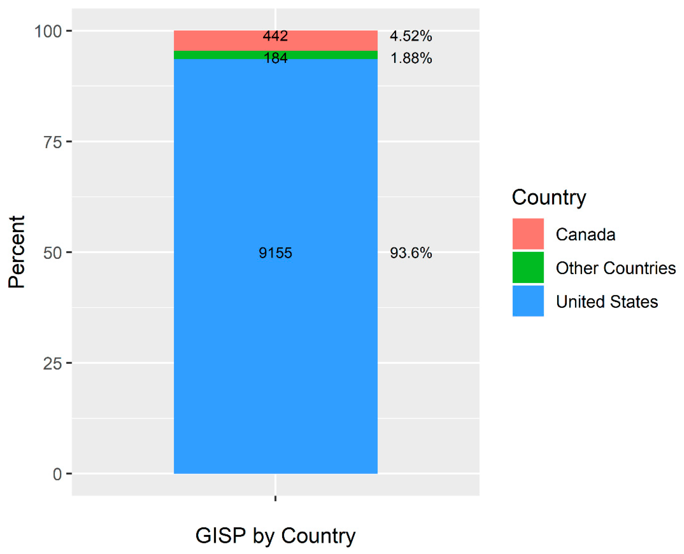
Several GIS-related certification programs have been developed in the U.S. to advance the development of this profession. For example, the GIS Professional (GISP) certification program was initiated in 2004 and is managed by a third-party organization—the GIS Certification Institute (GISCI). As of January 2019, this program has about 9155 members (including those whose certifications have expired) in the U.S. [
15]. The GISP certification program requires that applicants meet the portfolio requirements (educational achievement, professional experience, and contributions to the profession) and pass the exam before they can be certified. The GISP certification program has a point system and corresponding minimum requirements for each of the above-mentioned components in the portfolio review. Moreover, all certified GISPs need to sign a code of ethics, which is extremely important in the development of GIS as a profession [
16]. Specifically, the code of ethics includes a series of obligations to society, employers/funders, colleagues/the profession, and individuals in society [
16]. Note that many GIS degree programs focus on theories and techniques in GIS and usually only cover some aspects of ethics (e.g., research ethics, objectivity in presenting results), and professional certification programs can, and often do, build upon these through the inclusion of other dimensions of ethics related to the professional work setting. In addition to the GISP certification program, The American Society for Photogrammetry and Remote Sensing (ASPRS) also has its own GIS-related certification program—the Certified Mapping Scientist GIS/LIT [
17]. As of April 2020, this program has 288 members (including inactive members) [
18]. This certification program is relatively small when compared with the GISP Certification program. In addition to these two certification programs in the U.S., there are also other GIS certification programs outside the U.S. such as the Geomatics Specialist, GIS/LIS certification offered by the Canadian Institute of Geomatics (CIG) in Canada and the Geographic Information Systems Professional-Asia Pacific (GISP-AP) sponsored by the Surveying and Spatial Sciences Institute (SSSI) in Australia and New Zealand [
19]. Relevant research reveals that most GIS certification programs still primarily dominate in individual countries, and the internationalization of GIS certification is still in its infancy [
20]. Although most of the certified GISPs are still in the U.S., this program has started to be recognized internationally and been used as a good example in discussions about the development of new GIS certification programs outside the U.S. [
20]. A previous study found that 51% of the respondents agree or strongly agree that the GISP certification program is well-known in companies/agencies/organizations that hire GIS employees, while 21% of the respondents disagree with this argument [
17]. Although the GISP certification program is voluntary, it still has the potential to become as popular as the globally recognized Project Management Professional (PMP) certification program if it has a broader recognition in industry and government hiring practices. The success of a certification program could depend on many different factors such as advertisement/promotion, the management of the examination, and good collaboration with academia. As a top certification program in project management, the PMP program has a well-managed examination and relevant collaboration with academia [
21]. GIS certification programs could borrow some best practices from other successful certification programs (e.g., the PMP program) to further improve the quality and value of their programs and increase their popularity among GIS practitioners and employers.
GIS certification programs have played an important role in the development of this profession. However, very few studies have examined this topic. An early study by Wikle examined the characteristics of the above-mentioned four GIS certification programs based on the 2014 registry data downloaded from their websites [
19]. Specifically, Wikle found that 45% of the GISP certification holders work in government agencies, 42% of them work in industry/consulting, and 5% of them in are employed in higher education [
19]. Additionally, Mathews and Wikle [
17] did a survey on the GISPs’ characteristics including age, education, major, job title, employer, and income. Their study was based on the data collected from 1731 GISPs. They found that most respondents (93%) hold positions in the U.S., and the states with a large number of GISPs include California, Colorado, Florida, North Carolina, Texas, and the Washington DC area [
17]. Additionally, their job title analysis shows that most of the survey participants identified themselves as GIS analysts (29%), followed by GIS coordinators/managers (26%), GIS administrators (11%), GIS specialists (10%), and consultants (6%) [
17]. In this article, we aim to analyze all the GISPs’ characteristics based on the GISP registry data and other spatial data. We choose to study the GISP certification program because it accounts for over 95% of the certified GIS professionals in the U.S. [
19]. Compared with previous studies, the novelty of this study is two-fold. First, we analyze the individual-level characteristics (e.g., gender, job title, and employer) of all certified GISPs in the U.S. and map them out at the state level. Second, we employ spatial analysis to examine the spatial distribution patterns of the certified GISPs at the state level and identify the hotspots and coldspots in the U.S. This is a descriptive and exploratory study, and the findings could result in new research topics in this area.
The remainder of this article is organized as follows. The compilation, processing, and analysis of the data are provided in
Section 2. The results are presented in
Section 3. We provide some further discussion on the GISP certification program in
Section 4. Finally, we conclude the article in
Section 5.
2. Materials and Methods
2.1. Data Compilation and Processing
We acquired a copy of the GISP registry data from the GISCI in February 2019. This dataset includes the GISPs prior to January 2019 and is available as a text file in the Microsoft Excel format. Specifically, the following fields are included in the dataset: first name, middle name, last name, suffix, title, company, city, state, zip code, country, date of initial certification, expiration date, and certification number. This dataset has a total of 9781 records and includes both the GIS professionals with a currently valid GISP certification and those whose certifications have expired. Note that although the GISP certification program was originally designed for GIS professionals in the U.S., this program has also attracted a significant number of members from outside the U.S.
The first step is to process the tabular dataset and perform preliminary analysis on the following fields in the table: country, date of initial certification, and expiration date. Specifically, R is used to aggregate the records by country, and the GISPs in the U.S. are exported for further analysis.
In this U.S. dataset, we further divide the GISPs into two groups: those who have a valid certification and those with an expired certification (as of 1 January 2019). Additionally, we also derive the statistics of the length of certification for every record in the latter group by subtracting the date of initial certification from the expiration date. Since the GISP registry dataset only has zip code and state information for each certified GISP, we use R to aggregate the GISPs by zip code and state, respectively. The derived tabular zip code level GISP count dataset is joined to the zip code polygon data from the Environmental Systems Research Institute (ESRI) based on the zip code field. Similarly, we also derive GISP count data at the state level, and these data will also be used in subsequent spatial analysis in
Section 2.4.
Lastly, we use the urban areas and urban clusters datasets from the U.S. Census to compute the proportion of GISPs that fall within the urban and rural areas, respectively. According to the urban–rural classification scheme given by U.S. Census in the 2010 Census, an urban area includes a densely populated core of census tracts/blocks, its adjacent territory with non-residential urban land uses, and the territory that has a low population density but links the core and outlying densely settled territory. Specifically, urban areas can be further divided into two types: urbanized areas (UAs) and urban clusters (UCs). UAs are urban areas with a population of 50,000 or more people; UCs are urban areas with 2500–50,000 people [
22].
Table 1 lists a summary of the datasets used in this study.
2.2. Gender Classification
Gender classification has been widely used to examine gender differences or equality in many fields such as media [
25,
26] and academic publishing [
27]. To better study the gender composition of the certified GISPs, we classify the GISPs into two groups (male and female) based on their first names. The genderize.io tool is a web service that can classify gender based on a person’s first name. A recent study comparing different name-to-gender inference services indicates that the genderiz.io application programming interface (API) can predict gender based on a person’s first name with a high accuracy [
28]. The genderize.io API has been used to genderize first names in many studies such as gendered citation patterns [
29] and readers’ comment analysis [
26]. We clean the first names of the GISPs first. Then, we employ Python and the genderize.io API to genderize the GISPs. When using the genderize.io API, we specify that the country is the U.S. so that English names will be classified. Those GISPs with non-English first names will not be classified by the genderize.io API. The genderize.io API takes the first name as the input and returns the derived gender information. Note that each response also comes with a probability value that can indicate the certainty of the gender assigned to the input first name. The derived gender and probability information is stored in two new columns in the GISP registry dataset. After gender classification, we aggregate gender information at the state level and compute gender composition for each state.
2.3. Job Title and Employer Analysis
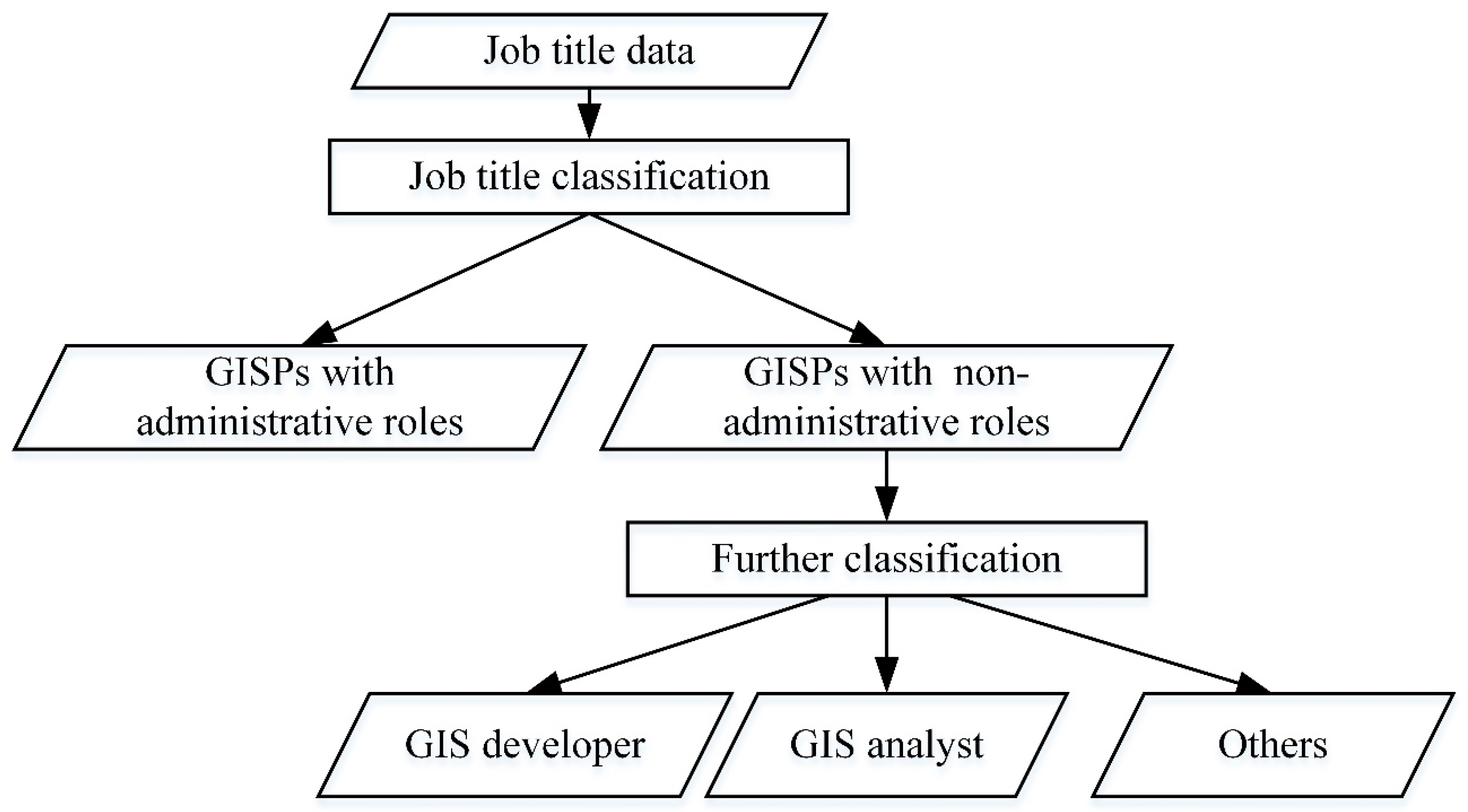
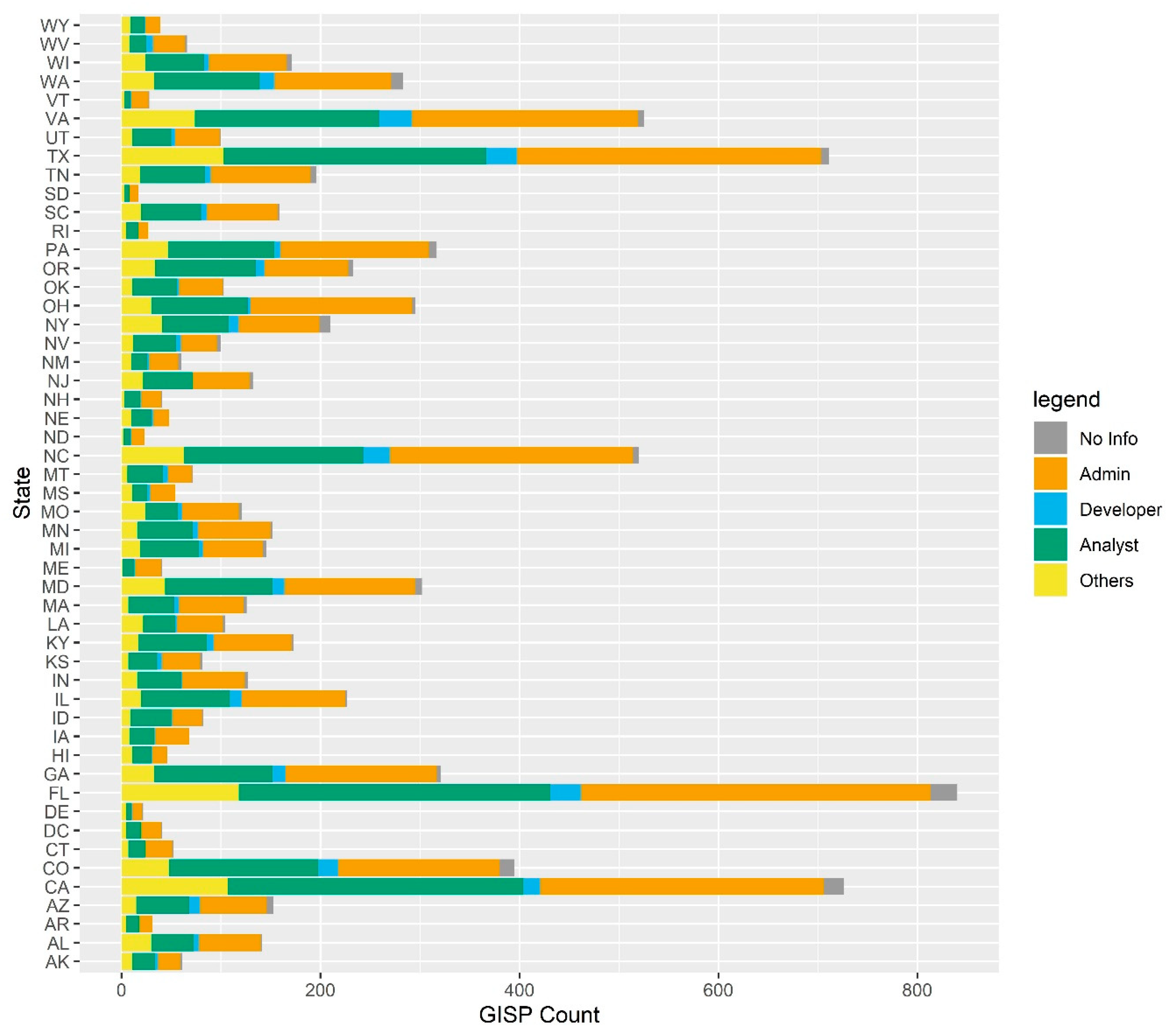
The certified GISPs have different types of job titles, and their job title information is included in the title column. A previous survey-based study found that the primary job titles include GIS analysts (29%), GIS managers/coordinators (26%), GIS administrators (11%), and GIS specialists (10%) [
17]. In this analysis, we aim to categorize the GISPs based on their job titles. As shown in
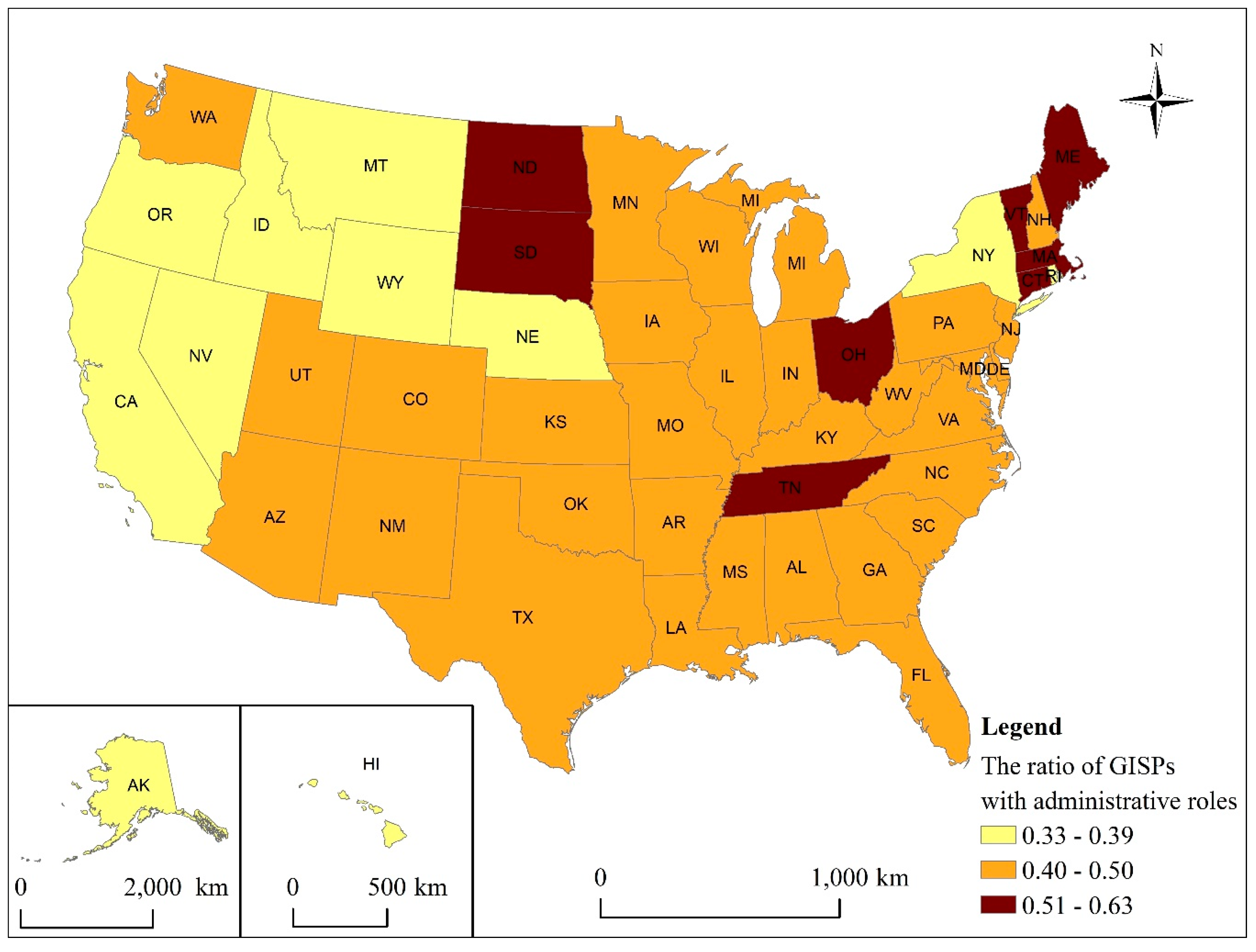
Figure 1, we first categorize the GISPs into two groups based on their responsibility: administrative and non-administrative. The administrative group includes those GISPs that play a managerial role (e.g., manager, supervisor, and team lead) in their organization, while the non-administrative group includes all other GISPs, who often play a technical role. Note that we include GIS coordinators in the administrative group in this analysis. After the initial classification, we proceed to further divide the GISPs in the non-administrative group into three sub-groups: GIS developer, GIS analyst, and others. We use a simple classification scheme in this study because the GISP registry dataset does not include very detailed information such as the type of instructor (tenure-track or non-tenure-track). However, this classification scheme could cover the primary job titles discovered in previous research.
The detailed job title classification procedure is as follows. First, the job title column is extracted from the U.S. GISP registry dataset, and each job title record is tokenized using a natural language processing Python library named Natural Language Toolkit (NLTK). All of the nouns are selected out, and each word is further split by forward slash to derive a list of words. The frequency of each word in the list is computed, and a list that includes the keywords that could indicate administrative roles is constructed by manually selecting the words in the frequency table. This list is represented as W = {w1, w2, …, wn}, and wn denotes the nth keyword in the list.
The next step is to classify the job titles (T = {t
1, t
2, …, t
n}) based on the constructed list W. Specifically, we iterate over W and compare each element in W with each record t in T. In each comparison, a similarity score will be derived, and this record is considered an administrative role if the similarity score reaches a specific threshold. We use a threshold of 90% to allow partial matching, which can take into account the records with typos. The detailed algorithm is shown in
Table 2, and this algorithm is implemented using Python. The FuzzyWuzzy Python library is used to match the keywords with each job title. We add a new column named “admin” to the GISP dataset. The GISPs with administrative and non-administrative roles are assigned 1 and 0, respectively. Those GISPs with no job title information are assigned −1.
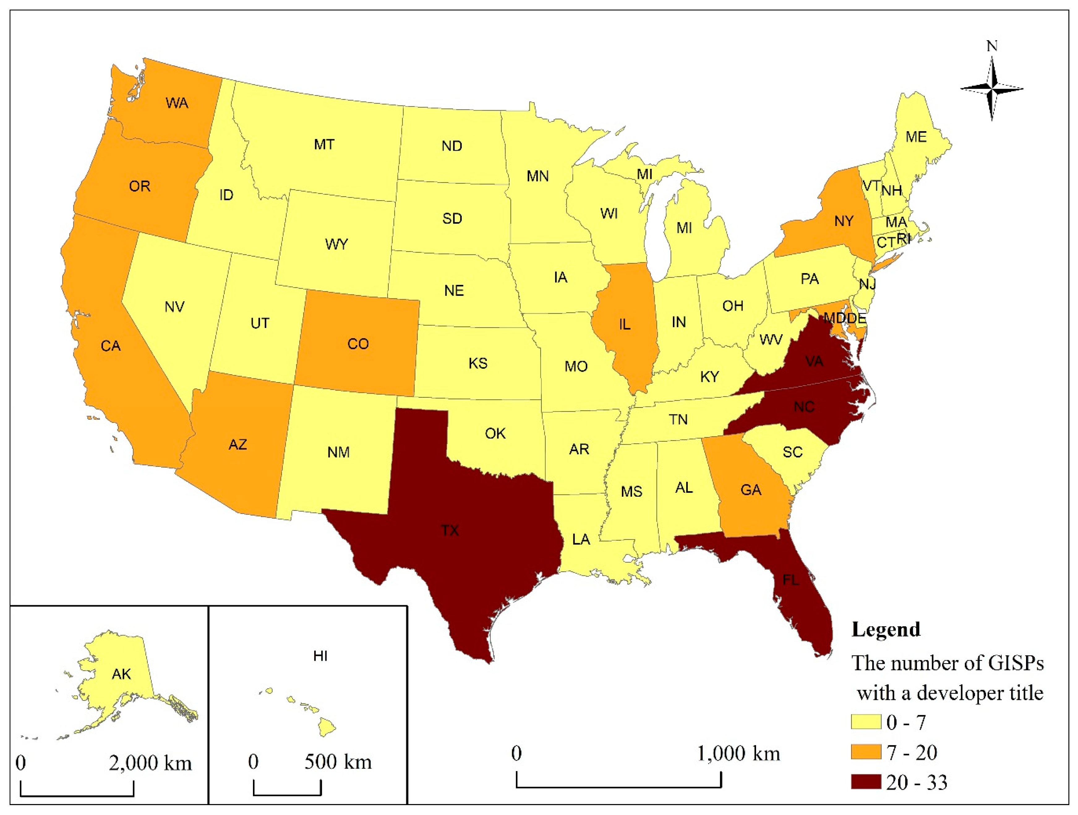
After the initial classification of job titles, we employ a similar procedure to construct a list of keywords for GIS developer and GIS analyst groups, respectively, to further classify the GISPs with non-administrative roles. A new column is appended to the GISP registry dataset to store the classification results. The GISPs in the administrative group are assigned 0. The GISPs falling within the GIS developer group are assigned 1, the GISPs in the GIS analyst group are assigned 2, and the rest of the GISPs with non-administrative roles are assigned 3. All those GISPs without job title information are assigned –1. The keywords for the GIS analyst group include “analyst”, “specialist”, and “technician”, and the keywords for the GIS developer group include “developer”, “programmer”, and “software engineer”.
Additionally, we also classify the GISPs based on their employers following Mathews and Wikle’s categorization of the GISPs in their survey on employer types, which include government agency, private industry, higher education, and not-for-profit organization [
17]. The GISP registry dataset has a “company” column that includes each GISP’s employer information. We use this column to divide the GISPs into three groups: (1) academic institutions, (2) government agencies, and (3) other types (e.g., companies or non-profit organizations). First, we employ a procedure similar to the job title analysis method to derive the keywords that can represent academic institutions and government agencies, respectively. Then, we proceed to use Python to classify the GISPs into the above-mentioned three groups. Specifically, the GISPs at academic institutions are assigned 1, those who work in government agencies are assigned 2, other GISPs who work for companies or non-profit organizations are assigned 0, and those without employer information are assigned −1. Due to the limited information in the GISP registry data, it is difficult to distinguish private industry from not-for-profit organizations, and therefore, we combined them into one category in our classification scheme.
2.4. Spatial Analysis
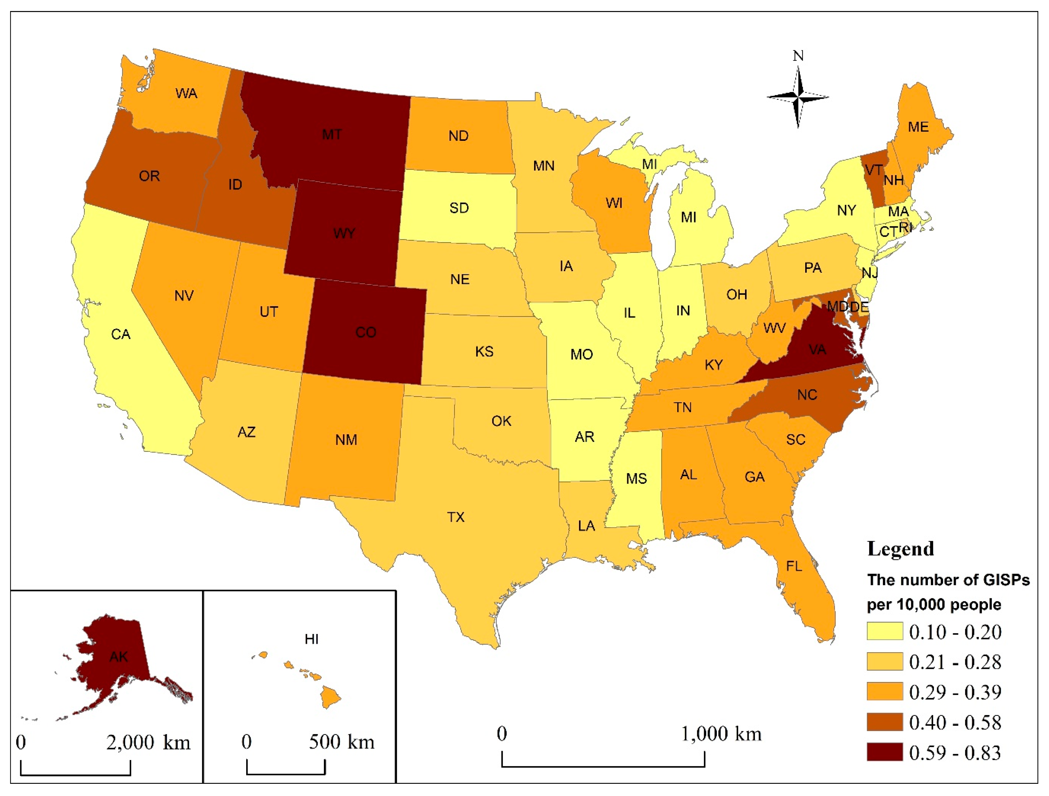
We compute the number of GISPs per 10,000 people in each state, and the derived state-level GISP data are used in subsequent spatial analysis. In the first step, global Moran’s I is used to examine if spatial autocorrelation exists. Global Moran’s I is a popular measure of spatial autocorrelation and overall clustering [
30], and it has been widely used to study the spatial patterns of different phenomena in many applications such as public health [
31,
32] and crime research [
33]. Specifically, global Moran’s I can be derived using the following equation:
where
is the value of the variable at location
,
is the weight for measuring the spatial autocorrelation of the two values at location
and
,
is the sample size,
is the number of neighbors for each x value at location
,
is the mean of x values, and s
2 is the variance of x values. Note that weight
can be derived based on the distance or the spatial adjacency relationship between location
and j. In this study, the weight matrix is computed based on the spatial adjacency (contiguity edges and corners) between the state boundary polygons. The global Moran’s I ranges from –1 (complete negative spatial autocorrelation) to 1 (complete positive spatial autocorrelation).
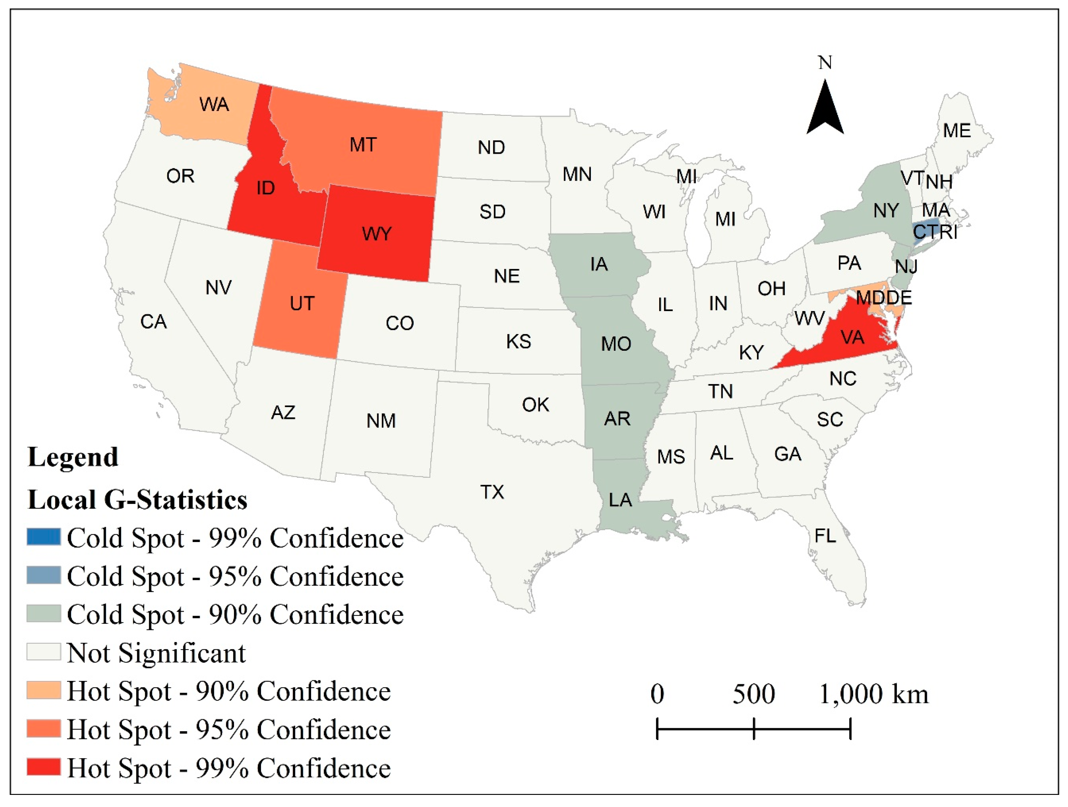
Since Moran’s I cannot distinguish if a cluster is made of low values or high values, we also employ the Getis-Ord Gi* statistic to identify the hotspots and coldspots of the GISPs at the state level. The Getis-Ord Gi* statistic is the local version of G-statistic [
34,
35], and it can be derived using the following equation:
where
is the local G-statistic for observation
, m is the number of neighbors of observation
,
is the value of a neighbor of observation
, and
is the mean value of observations.
4. Discussion
This study analyzes the characteristics of the certified GISPs in the U.S., which provides relevant information for GIS researchers and practitioners to conduct further discussions on the GISP certification program and other related topics in GIS education and professional development.
First, it remains a challenge to incorporate all aspects of GIS in the GISP certification program. This issue was mentioned in the early discussions on GIS certification programs [
5,
6]. However, it remains to be resolved today [
17]. This study shows that only a small percentage of GISPs are GIS developers. Note that the skill set for GIS developers is very different from that for GIS analysts. GIS developers focus on software development, while GIS analysts primarily deal with the applications of GIS in different disciplines. Furthermore, GIS developers could also be further divided into many categories such as front-end developer, back-end developer, and full-stack developers. This difference poses a great challenge for the GISCI to design the GISP examination. Although the current GISP examination covers the content for both developers and analysts, its focus is still on the core skills and knowledge. Further investigation is needed on how to improve the test and make it fit different types of GIS practitioners.
Second, equally important to the development of GIS as a profession is to figure out how to better integrate GIS with subject matters in GIS education. This was also listed as a challenge in GIS certification in the early discussions [
5]. GIS has been widely used in a variety of fields (e.g., transportation, public health, natural resource management, and national defense) in the past few decades. In many cases, the employers in these fields will need those who have both GIS skills and a solid foundation in the subject matters. Most GIS programs are within Geography departments in the U.S., and interdisciplinary collaboration can never be overemphasized in the design and development of GIS curricula. For example, those universities located in urban areas could incorporate more urban planning courses into their GIS curricula so that their graduates can better fill those GIS positions in urban planning sectors. Note that GIS curriculum design and development should be based on the local or regional context, and data-driven approaches should be adopted whenever possible in decision-making. For example, universities/departments with enough resources could hire some consulting companies to study the job market and the employers’ needs so that they can adjust their GIS curricula based on this information to better fit the needs. This study shows that 88.4% of the GISPs are in urbanized areas in the U.S., which reveals that most GIS jobs are located in urbanized areas in the U.S. This will be valuable to universities in their planning of the GIS programs as well as finding opportunities to link GIS-related coursework to other disciplines such as urban planning and public administration.
Third, more research should be conducted to further examine the relationship between GIS higher education and the GISP certification program. Mathews and Wikle found that over 87% of the respondents in their survey have a bachelor’s degree and nearly 50% hold a graduate degree [
17]. Additionally, Mathews and Wikle have also done some research on the GIS pedagogies and instructional methods in higher education [
40]. Given that every university has the freedom to design their GIS curricula, GIS certification programs can serve as a good complement to GIS higher education in the U.S. Mathews and Wikle also mentioned that only 25% of the respondents in their study have a GIS degree, 40% have a geography degree, and the rest of the respondents have a degree in other disciplines such as computer science, planning, geology, and engineering [
17]. The GISP certification program could be of great value to those without a GIS/geography degree. Note that the GIS curricula at many universities are based on the National Center for Geographic Information and Analysis (NCGIA) Core Curriculum in GIS. With the rapid development of geospatial technologies in the past few years, it is often difficult for curricula to keep up with all the emerging technology and trends. Similar to other fields of study, scholars have noted the education–workforce divide that exists in GIS [
17]. One approach toward closing this gap may be to seek opportunities to encourage more collaboration between academia and professional certification programs in educating current and the next generation of GIS professionals. The goals of both academia and professional certifications are not necessarily mutually exclusive, and both would benefit from cultivating continual learning in GIS, as this area grows and evolves. For example, GIS programs offered in universities across the country cover fundamental knowledge, concepts, and skill sets often tested on the GISP exam. Making students aware of not only how the material covered in their university courses contributes to the development of their knowledge and skills in this area, but also that this information can help them work toward their professional certification once they enter the workforce would be valuable in their continual professional development even after graduation. The derived job title information of the certified GISPs in this study could reflect the spatial distribution of different types of GIS jobs in the U.S., which could be leveraged by GIS educators to adjust their GIS curricula. For example, those GIS programs in the states that have a large number of GIS Developer-type GISPs could consider adding more courses on GIS development so as to better meet the needs.
Lastly, since the GISP registry data showed that many certifications had expired, we further examined the GISPs with an expired certification. We found that among the 2954 GISPs with an expired certification, 1337 persons (45%) work in companies or non-profit organizations, 120 people (4%) work in academia, 1153 people (39%) work in government agencies, and 344 people (12%) do not have employer information. Additionally, we also examined this group of GISPs by job title, and the number of GISPs with an administrative role is 1342 (45%), followed by GIS analyst (1021, 35%), others (369, 12%), and GIS developer (131, 4%). The number of GISPs with an expired certification is proportional to the total number of GISPs in each category. It is important that we invest more resources to increase the value of the GISP certification program and further promulgate this program among GIS practitioners and employers. First, we need to ensure that the GISP certification program is current and can reflect the tools and technology used in practice. Second, the GISCI could further work with employers and academic institutions to publicize the GISP certification program. With regard to research, very few studies have involved the information or feedback from the employers. It will be more meaningful to bring employers into this dialogue. Lastly, scholars in academia could also collaborate with the GISCI and other professional organizations such as the Urban and Regional Information Systems Association (URISA), the American Association of Geographers (AAG), and the Association for Computing Machinery (ACM) Special Interest Group on Spatial Information (SIGSPATIAL) to help improve the GISP certification program and the GIS degree programs. For example, URISA has been organizing GISP certification exam preparation workshops during its GIS-Pro meetings. Relevant research could explore opportunities in which GIS-related professional associations could facilitate and advance GIS certification programs. Additionally, similar studies could be carried out to examine the perceptions of GIS professional have about (1) what should be required for a certification in GIS, (2) opportunities for advancing the profession through increased professionalization and certification, and (3) the emerging and future needs in the field that can be considered in the certification process. The above-mentioned efforts could increase the value of the GISP certification and contribute to building a more active GIS community.
5. Conclusions
We present a descriptive and exploratory study on the GISP certification program in the U.S. This study examines the characteristics of the members in the most popular GISP certification program in the U.S. and provides novel information through relevant state-level spatial analysis. The results show that the majority of GISPs (97.3%) are located in urban areas. The majority of the certified GISPs (about 75%) are male. Among all the GISPs, 3971 GISPs (43.3%) play a managerial role, while 4983 individuals (54.5%) assume a non-administrative role. Among the GISPs with a non-administrative role, 348 GISPs (7%) fall within the GIS Developer group, 3392 GISPs (68%) belong to the GIS Analyst group, and 1243 GISPs (25%) play other roles. Additionally, we identified two hotspots and two coldspots in our spatial analysis. The first hotspot is centered around Idaho and Wyoming, while the second hotspot includes Virginia, Washington DC, and Maryland. One coldspot is along Iowa, Missouri, Arkansas, and Louisiana in the central U.S., while the other coldspot includes states such as Connecticut, New Jersey, and New York on the east coast. This empirical research enriches the existing literature by deriving new characteristics and spatial patterns of the certified GISPs in the U.S. Additionally, the findings of this study could help identify potential topics for future research.
This study has policy and practical implications. First, the findings of this study advances knowledge about the current status of GIS certifications, and more specifically, patterns related to who is acquiring GISP certification and where these certifications are acquired and utilized. The derived characteristics of the GISPs in the U.S. depict a holistic picture of the current state of this certification program, which is significantly valuable to the advancement to the further professionalization of the GIS field. Second, this study visualizes the spatial patterns of GIS jobs based on the characteristics of the GISPs and provides valuable information for GIS educators when proposing, developing, and improving their GIS programs and curricula. Furthermore, the derived information about the GISPs is also useful to those who intend to choose GIS as their profession. Lastly, this study can also shed light on opportunities for improving the GISP certification program and help bridge the education–workforce divide.
This study has some limitations due to its descriptive nature. First, it relies on the GISP registry data and is restricted to a few characteristics such as job title, gender, and employer. Future research could be conducted to further examine the potential reasons for the results found in this study. For example, relevant survey-based research could be done to investigate why some GISPs choose not to renew their certifications. Second, we could also leverage big data (e.g., the GIS job advertisement data from job posting websites) to derive the characteristics of GIS jobs (e.g., job location, job type) in the U.S. and use this information to provide valuable insight into the market needs of these areas. Another opportunity for future research would be to examine the representation of females with respect to the total number of GISP holders. Despite steady increases in the number of women earning bachelor’s degrees in Geography, the number of women seeking this professional certification is low. Examination into why so few women are seeking certification is essential in order to identify any barriers that may exist with respect to entry into this profession and opportunities for advancement in the GIS professional workforce. Future research can also analyze the extent to which the patterns identified in this study are similar or different from GIS professionals across the globe. Additionally, future work could also explore how GIS professionals outside the U.S. perceive the GISP certificaion to be of value to them in their work and to explore opportunities to engage the international community in improving the GISP certificaion program and enhancing training within the global GIS community. These future research initiatives could help GIS researchers and practitioners develop a better understanding of the GISP certification program and facilitate the development of GIS as a profession.


