Comparative Analysis of Firearm Discharge Recorded by Gunshot Detection Technology and Calls for Service in Louisville, Kentucky


Abstract
1. Introduction
1.1. Gunshot Detection Technology
1.2. Spatial Clustering of Gun Violence
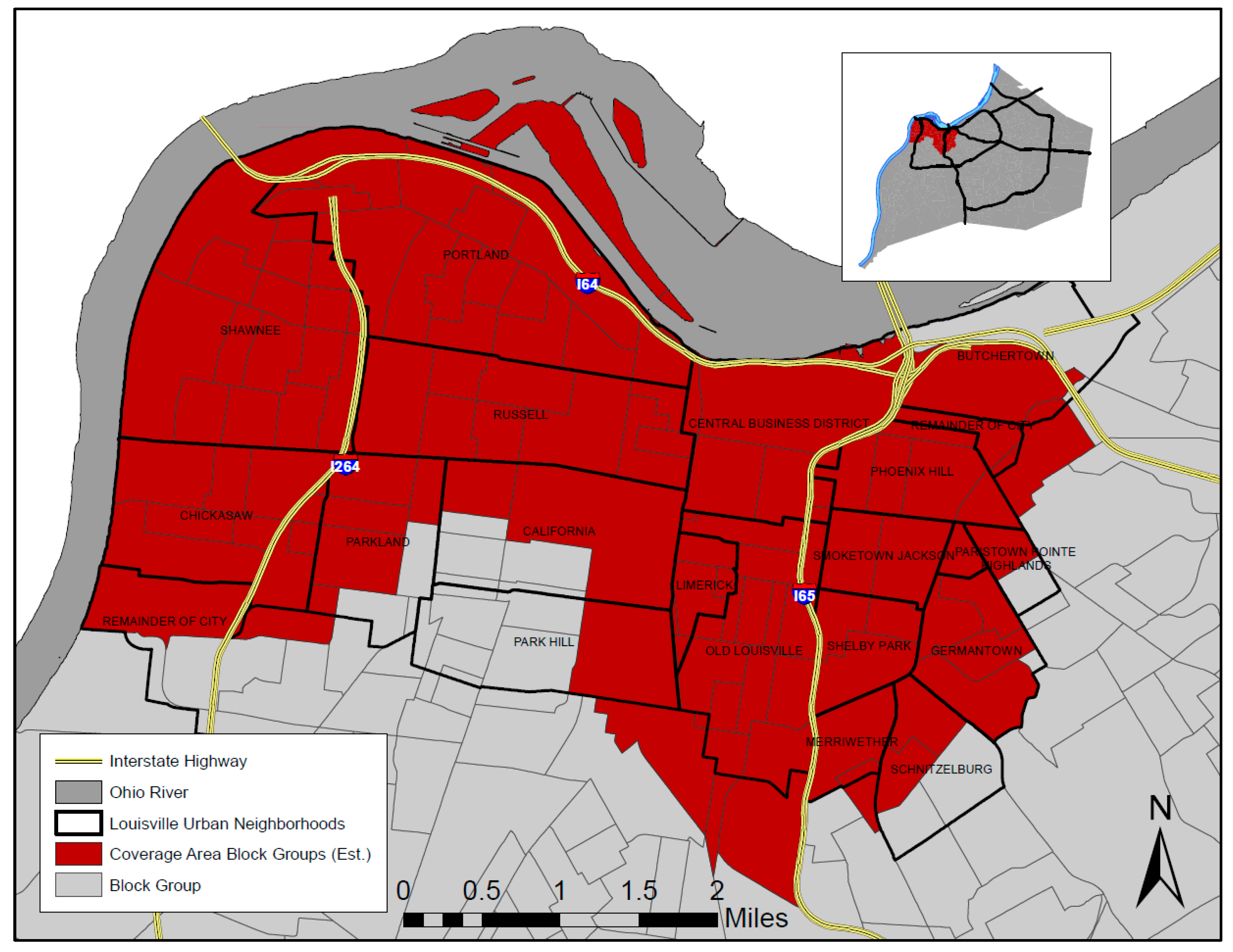
2. Data and Methods
3. Results
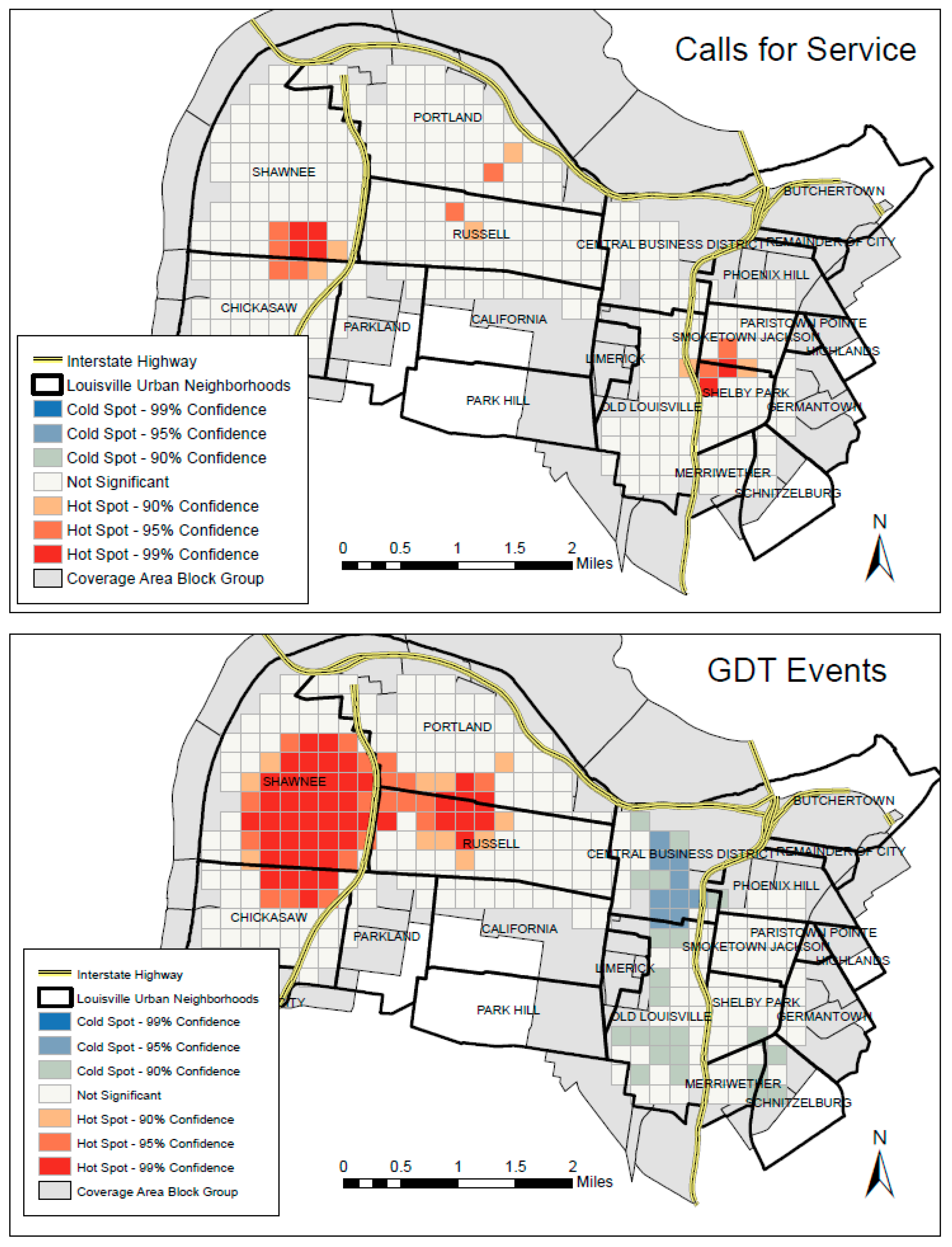
3.1. Spatial and Temporal Patterns of Gunshots
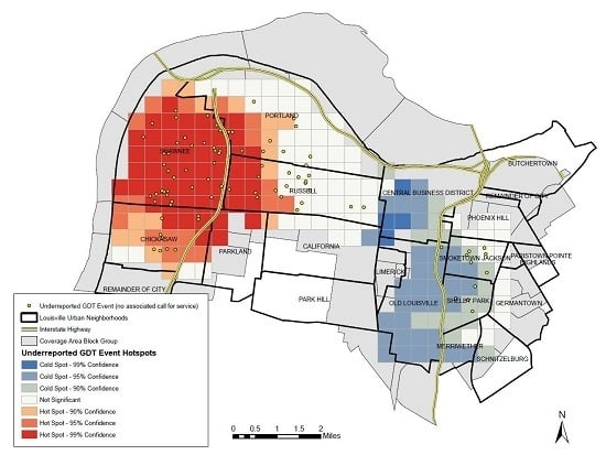
3.2. Hotspot Analysis
3.3. Near Repeat Analysis
3.4. Regression Analysis
4. Discussion and Conclusions
Author Contributions
Funding
Acknowledgments
Conflicts of Interest
References
- Wintemute, G.J. The epidemiology of firearm violence in the twenty-first century United States. Annu. Rev. Public Health 2015, 36, 5–19. [Google Scholar] [CrossRef] [PubMed]
- Bauchner, H.; Rivara, F.P.; Bonow, R.O.; Bressler, N.M.; Disis, M.L. (Nora); Heckers, S.; Piccirillo, J.F.; Redberg, R.F.; Rhee, J.S.; Robinson, J.K.; et al. Death by gun violence—A public health crisis. JAMA Intern. Med. 2017. [Google Scholar] [CrossRef] [PubMed]
- CDC. Firearm Mortality by State. Available online: www.cdc.gov/nchs/pressroom/sosmap/firearm_mortality/firearm.html (accessed on 24 April 2018).
- Fowler, K.A.; Dahlberg, L.L.; Haileyesus, T.; Annest, J.L. Firearm injuries in the United States. Prev. Med. 2015, 79, 5–14. [Google Scholar] [CrossRef] [PubMed]
- Braga, A.A.; Papachristos, A.V.; Hureau, D.M. The concentration and stability of gun violence at micro places in Boston, 1980–2008. J. Quant. Criminol. 2010, 26, 33–53. [Google Scholar] [CrossRef]
- Larsen, D.A.; Lane, S.; Jennings-Bey, T.; Haygood-El, A.; Brundage, K.; Rubinstein, R.A. Spatio-temporal patterns of gun violence in Syracuse, New York 2009–2015. PLoS ONE 2017, 12, e0173001. [Google Scholar] [CrossRef] [PubMed]
- Weisburd, D. The law of crime concentration and the criminology of place. Criminology 2015, 53, 133–157. [Google Scholar] [CrossRef]
- Hills-Evans, K.; Mitton, J.; Sacks, C.A. Stop posturing and start problem solving: A call for research to prevent gun violence. AMA J Ethics 2018, 20, 77–83. [Google Scholar] [CrossRef] [PubMed][Green Version]
- Carr, J.; Doleac, J.L. The geography, incidence, and underreporting of gun violence: New evidence using ShotSpotter data. SSRN Electron. J. 2016. [Google Scholar] [CrossRef]
- Lawrence, D.S.; La Vigne, N.G.; Goff, M.; Thompson, P.S. Lessons Learned Implementing Gunshot Detection Technology: Results of a Process Evaluation in Three Major Cities. Justice Eval. J. 2018, 1, 109–129. [Google Scholar] [CrossRef]
- Mazerolle, L.G.; National Institute of Justice. Random Gunfire Problems and Gunshot Detection Systems; U.S. Department of Justice, Office of Justice Programs, National Institute of Justice: Washington, DC, USA, 1999; p. 7.
- Ratcliffe, J.H.; Lattanzio, M.; Kikuchi, G.; Thomas, K. A partially randomized field experiment on the effect of an acoustic gunshot detection system on police incident reports. J. Exp. Criminol. 2019, 15, 67–76. [Google Scholar] [CrossRef]
- Choi, K.-S.; Librett, M.; Collins, T.J. An empirical evaluation: Gunshot detection system and its effectiveness on police practices. Police Pract. Res. 2014, 15, 48–61. [Google Scholar] [CrossRef]
- Watkins, C.; Green Mazerolle, L.; Rogan, D.; Frank, J. Technological approaches to controlling random gunfire: Results of a gunshot detection system field test. Polic. Int. J. 2002, 25, 345–370. [Google Scholar] [CrossRef]
- Irvin-Erickson, Y.; La Vigne, N.; Levine, N.; Tiry, E.; Bieler, S. What does Gunshot Detection Technology tell us about gun violence? Appl. Geogr. 2017, 86, 262–273. [Google Scholar] [CrossRef]
- Litch, M.; Shaw, S. Implementing the SECURES urban gunshot detection technology for law enforcement crime intervention strategies. In Proceedings of the Sensors, and Command, Control, Communications, and Intelligence (C3I) Technologies for Homeland Security and Homeland Defense III, Baltimore, MD, USA, 20–22 April 2015; pp. 484–493. [Google Scholar]
- Freire, I.; Apolinario, J. Gunshot detection in noisy environments. In Proceeding of the 7th International Telecommunications Symposium, Manaus, Brazil, September 2010; Available online: http://www.ime.eb.br/~apolin/papers/ITS2010Izabela.pdf (accessed on 13 June 2019).
- Loeffler, C.; Flaxman, S. Is gun violence contagious? A spatiotemporal test. J. Quant. Criminol. 2018, 34, 999–1017. [Google Scholar] [CrossRef]
- Steenbeek, W.; Weisburd, D. Where the action is in crime? an examination of variability of crime across different spatial units in the hague, 2001–2009. J. Quant. Criminol. 2016, 32, 449–469. [Google Scholar] [CrossRef]
- Andresen, M.A.; Curman, A.S.; Linning, S.J. The trajectories of crime at places: Understanding the patterns of disaggregated crime types. J. Quant. Criminol. 2017, 33, 427–449. [Google Scholar] [CrossRef]
- Mohler, G. Marked point process hotspot maps for homicide and gun crime prediction in Chicago. Int. J. Forecast. 2014, 30, 491–497. [Google Scholar] [CrossRef]
- Wells, W.; Wu, L.; Ye, X. Patterns of near-repeat gun assaults in Houston. J. Res. Crime Delinq. 2012, 49, 186–212. [Google Scholar] [CrossRef]
- Sturup, J.; Rostami, A.; Gerell, M.; Sandholm, A. Near-repeat shootings in contemporary Sweden 2011 to 2015. Secur. J. 2018, 31, 73–92. [Google Scholar] [CrossRef]
- Wyant, B.R.; Taylor, R.B.; Ratcliffe, J.H.; Wood, J. Deterrence, firearm arrests, and subsequent shootings: A micro-level spatio-temporal analysis. Justice Q. 2012, 29, 524–545. [Google Scholar] [CrossRef]
- Sturup, J.; Gerell, M.; Rostami, A. Explosive violence: A near-repeat study of hand grenade detonations and shootings in urban Sweden. Eur. J. Criminol. 2019. [Google Scholar] [CrossRef]
- Ratcliffe, J.H.; Rengert, G.F. Near-repeat patterns in Philadelphia shootings. Secur. J. 2008, 21, 58–76. [Google Scholar] [CrossRef]
- Townsley, M.; Homel, R.; Chaseling, J. Infectious burglaries. A test of the near repeat hypothesis. Br. J. Criminol. 2003, 43, 615–633. [Google Scholar] [CrossRef]
- Anyinam, C. Investigating the applicability of the near-repeat spatio-temporal phenomenon to shot(s) fired incidents: A city level analysis. Crime Mapp. Anal. News. 2016, Fall 2016, 9. [Google Scholar]
- Mazeika, D.M.; Uriarte, L. The near repeats of gun violence using acoustic triangulation data. Secur. J. 2018. [Google Scholar] [CrossRef]
- Haberman, C.P.; Ratcliffe, J.H. The predictive policing challenges of near repeat armed street robberies. Polic. J. Policy Pract. 2012, 6, 151–166. [Google Scholar] [CrossRef]
- He, L.; Paez, A.; Liu, D. Persistance of crime hot spots: An ordered probit analysis. Geogr. Anal. 2017, 2017, 3–22. [Google Scholar] [CrossRef]
- Sampson, R.J.; Groves, W.B. Community structure and crime: Testing social disorganization theory. Am. J. Sociol. 1989, 94, 774–802. [Google Scholar] [CrossRef]
- Shaw, C.R.; Mckay, H.D. Juvenile Delinquency and Urban Areas: A Study of Rates of Delinquencies in Relation to Differential Characteristics of Local Communities in American Cities; University of Chicago Press: Chicago, IL, USA, 1942. [Google Scholar]
- Bursik, R.J., Jr. The informal control of crime through neighborhood networks. Sociol. Focus 1999, 32, 85–97. [Google Scholar] [CrossRef]
- Ekins, E. Policing in America: Understanding Public Attitudes Toward the Police. Results from a National Survey; CATO Institute: Washington, DC, USA, 2016. [Google Scholar]
- Morin, R.; Stepler, R. The Racial Confidence Gap in Police Performance; Pew Research Center: Washington, DC, USA, 2016. [Google Scholar]
- Mrug, S.; Madan, A.; Cook, E.W., 3rd; Wright, R.A. Emotional and physiological desensitization to real-life and movie violence. J. Youth Adolesc. 2015, 44, 1092–1108. [Google Scholar] [CrossRef]
- Tella, R.; Freira, L.; Gálvez, R.; Schargrodsky, E.; Shalom, D.; Sigman, M. Crime and violence: Desensitization in victims to watching criminal events. J. Econ. Behav. Organ. 2017. [Google Scholar] [CrossRef]
- Wilson, J.Q.; Kelling, G.L. The police and neighborhood safety: Broken windows. Atl. Mon. 1982, 127, 29–38. [Google Scholar]
- SST Inc. ShotSpotter Whitepaper: Gunshot Detection Technology; SST Inc.: Rowley, MA, USA, 2014. [Google Scholar]
- Tita, G.E.; Petras, T.L.; Greenbaum, R.T. Crime and residential choice: A neighborhood level analysis of the impact of crime on housing prices. J. Quant. Criminol. 2006, 22, 299. [Google Scholar] [CrossRef]
- International Association of Crime Analysis. Identifying High Crime Areas (White Paper 2013-02); International Association of Crime Analysis: Overland Park, KS, USA, 2013. [Google Scholar]
- Ratcliffe, J. Near Repeat Calculator (Version 1.3); Temple University and the National Institute of Justice: Philidelphia, PA, USA; Washington, DC, USA, 2009.
- Derickson, K.D. Urban geography II: Urban geography in the Age of Ferguson. Prog. Hum. Geogr. 2016, 41, 230–244. [Google Scholar] [CrossRef]
- Pyrooz, D.C.; Decker, S.H.; Wolfe, S.E.; Shjarback, J.A. Was there a Ferguson Effect on crime rates in large U.S. cities? J. Crim. Justice 2016, 46, 1–8. [Google Scholar] [CrossRef]
- Anselin, L.; Syabri, I.; Kho, Y. GeoDa: An introduction to spatial data analysis. Geogr. Anal. 2006, 38, 5–22. [Google Scholar] [CrossRef]
- Beard, J.H.; Morrison, C.N.; Jacoby, S.F.; Dong, B.; Smith, R.; Sims, C.A.; Wiebe, D.J. Quantifying disparities in urban firearm violence by race and place in Philadelphia, Pennsylvania: A cartographic study. Am. J. Public Health 2017, 107, 371–373. [Google Scholar] [CrossRef] [PubMed]
- Hill, B.; Paynich, R. Fundamentals of Crime Mapping; Jones & Bartlett Publishers: Burlington, MA, USA, 2013. [Google Scholar]
- Chainey, S.P.; da Silva, B.F.A. Examining the extent of repeat and near repeat victimisation of domestic burglaries in Belo Horizonte, Brazil. Crime Sci. 2016, 5, 1. [Google Scholar] [CrossRef]
- Sagovsky, A.; Johnson, S.D. When does near repeat burglary victimization occur? Aust. N. Z. J. Criminol. 2007, 40, 1–26. [Google Scholar] [CrossRef]


| Land Use Type | Count of GDT Events | Area (Square Feet) | Percent of Total GDT Events | Location Quotient |
|---|---|---|---|---|
| Single Family | 433 | 71,302,619 | 59% | 2.16 |
| Multi-Family | 85 | 13,543,773 | 12% | 2.23 |
| Vacant | 54 | 6,677,930 | 7% | 2.88 |
| Public and Semi-Public | 49 | 21,579,088 | 7% | 0.81 |
| Right-of-Way | 45 | 90,720,183 | 6% | 0.18 |
| Commercial | 42 | 18,904,670 | 6% | 0.79 |
| Parks and Open Space | 12 | 21,838,937 | 2% | 0.20 |
| Industry | 9 | 14,916,793 | 1% | 0.21 |
| Total | 729 | 259,483,992 | 100% |
| Disposition | GDT Event | Calls for Service - Shots Fired |
|---|---|---|
| Advised event | <1% | <1% |
| Arrest | <1% | <1% |
| Attempt to locate | <1% | 2% |
| Canceled | 1% | 1% |
| CIT paperwork completed | <1% | <1% |
| Clear with no report | 43% | 52% |
| Duplicate event | 1% | 2% |
| Duplicate event cancelled | 5% | 8% |
| Information only | <1% | <1% |
| Other | <1% | 1% |
| Report taken | 12% | 3% |
| Transferred to another agency | <1% | <1% |
| Unfounded | 38% | 31% |
| Total | 100% | 100% |
| Spatial Intervals | Same Location | 1 to 400 Feet | 401 to 800 Feet | 801 to 1200 Feet | More than 1200 Feet | |
|---|---|---|---|---|---|---|
| Temporal Bandwidth | ||||||
| Within one week | 3.17 * | 1.31 * | 1.14 * | 0.98 | 1 | |
| One to two weeks | 1.12 | 1.04 | 1.21 * | 1.09 | 1 | |
| Two to three weeks | 0.59 | 0.86 | 0.85 | 1.01 | 1 | |
| More than three weeks | 0.72 | 0.97 | 0.97 | 0.99 | 1 | |
| 0 to 1 days | 19.00 * | 2.73 * | 2.32 * | 1.05 | 0.98 | |
| 2 to 2 days | 4.07 * | 1.71 * | 1.2 | 0.94 | 1 | |
| 3 to 3 days | 2.04 | 1.35 | 0.78 | 1.07 | 1 | |
| 4 to 4 days | 1.12 | 1.31 | 1.14 | 0.88 | 1 | |
| 5 to 5 days | 1.81 | 0.91 | 0.87 | 1.01 | 1 | |
| 6 to 6 days | 0 | 0.44 | 1.07 | 1.06 | 1 | |
| Variables Analyzed | Mean | S.D. |
|---|---|---|
| GDT events (Dependent variable for All GDT models) | 8.89 | 10.19 |
| Underreported GDT events (Dependent variable for Underreporting models) | 3.94 | 5.10 |
| Single-parent households | 70% | 28% |
| Vacant property | 18% | 11% |
| Population homogeneity (% blacks) | 59% | 34% |
| Median income | $26,501 | $10,852 |
| No high school diploma (% age 25+) | 19% | 11% |
| Households in poverty | 31% | 22% |
| Renter occupied | 65% | 22% |
| Males aged 15–25 | 16% | 16% |
| Median age | 35.5 | 9.9 |
| Households with children | 46% | 32% |
| Female-headed households | 52% | 10% |
| Variables | OLS Model | Spatial Lag Model | ||
|---|---|---|---|---|
| Coefficient | t-statistic | Coefficient | t-statistic | |
| Constant | −5.017 | −0.405 | −5.099 | −0.502 |
| Single-parent households | 0.284 | 0.057 | −1.221 | −0.299 |
| Vacant property | 23.734 | 2.521 | 12.746 | 1.630 |
| Population homogeneity (% blacks) | 13.906 | 3.292 | 7.628 | 2.065 * |
| Median income | 0.000 | −0.904 | 0.000 | −0.714 |
| No high school diploma (% age 25+) | 15.025 | 1.327 | 13.129 | 1.396 |
| Households in poverty | −4.636 | −0.783 | −2.039 | −0.420 |
| Renter occupied | −6.465 | −1.123 | −1.032 | −0.218 |
| Males aged 15-25 | 0.796 | 0.099 | 0.657 | 0.099 |
| Median age | −0.040 | −0.285 | −0.091 | −0.777 |
| Households with children | 1.109 | 0.221 | −0.935 | −0.227 |
| Female-headed households | 13.990 | 1.177 | 13.071 | 1.341 |
| Spatial lag term | n, a. | 0.548 | 5.031 * | |
| Adjusted R-Squared | 0.314 (p-value = 0.000) | 0.533 (p = 0.000) | ||
| Akaike’s Information Criterion (AIC) | 600.877 | 581.592 | ||
| Likelihood Ratio Test | 13.932 (p = 0.000) | |||
| Moran’s I among residuals | 0.188 (p = 0.000) | 0.025 (p = 0.190) | ||
| Variables | OLS Model | Spatial Lag Model | ||
|---|---|---|---|---|
| Coefficient | t-Statistic | Coefficient | t-Statistic | |
| Constant | −4.301 | −0.664 | −4.439 | −0.785 |
| Single-parent households | 0.321 | 0.123 | 0.068 | 0.030 |
| Vacant property | 9.656 | 1.963 | 6.057 | 1.397 |
| Population homogeneity (% blacks) | 7.073 | 3.205 | 4.659 | 2.264 * |
| Median income | 0.000 | 0.018 | 0.000 | 0.173 |
| No high school diploma (age 25+) | 9.501 | 1.606 | 8.270 | 1.584 |
| Households in poverty | −2.327 | −0.752 | −1.635 | −0.604 |
| Renter occupied | −3.669 | −1.219 | −1.262 | −0.476 |
| Males aged 15-25 | 1.882 | 0.446 | 1.999 | 0.542 |
| Median age | 0.007 | 0.093 | −0.006 | −0.099 |
| Households with children | 0.023 | 0.009 | −0.346 | −0.151 |
| Female-headed households | 5.383 | 0.867 | 4.629 | 0.853 |
| Spatial lag term | n. a. | 0.393 | 2.996 * | |
| Adjusted R-Squared | 0.251 (p = 0.000) | 0.421 (p = 0.000) | ||
| Akaike information criterion (AIC) | 494.399 | 482.547 | ||
| Moran’s I among residuals | 0.137 (p = 0.005) | 0.006 (p = 0.400) | ||
© 2019 by the authors. Licensee MDPI, Basel, Switzerland. This article is an open access article distributed under the terms and conditions of the Creative Commons Attribution (CC BY) license (http://creativecommons.org/licenses/by/4.0/).
Share and Cite
Renda, W.; Zhang, C.H. Comparative Analysis of Firearm Discharge Recorded by Gunshot Detection Technology and Calls for Service in Louisville, Kentucky. ISPRS Int. J. Geo-Inf. 2019, 8, 275. https://doi.org/10.3390/ijgi8060275
Renda W, Zhang CH. Comparative Analysis of Firearm Discharge Recorded by Gunshot Detection Technology and Calls for Service in Louisville, Kentucky. ISPRS International Journal of Geo-Information. 2019; 8(6):275. https://doi.org/10.3390/ijgi8060275
Chicago/Turabian StyleRenda, William, and Charlie H. Zhang. 2019. "Comparative Analysis of Firearm Discharge Recorded by Gunshot Detection Technology and Calls for Service in Louisville, Kentucky" ISPRS International Journal of Geo-Information 8, no. 6: 275. https://doi.org/10.3390/ijgi8060275
APA StyleRenda, W., & Zhang, C. H. (2019). Comparative Analysis of Firearm Discharge Recorded by Gunshot Detection Technology and Calls for Service in Louisville, Kentucky. ISPRS International Journal of Geo-Information, 8(6), 275. https://doi.org/10.3390/ijgi8060275