Harmonising the OGC Standards for the Built Environment: A CityGML Extension for LandInfra


Abstract
1. Introduction
2. Background
2.1. CityGML
2.2. LandInfra and InfraGML
3. Methodology
Mapping between LandInfra and CityGML
- Classes (and their attributes) which can be directly mapped from LandInfra to CityGML, e.g., LI::LandSurface with CG::TINRelief, LI::Road with CG::Road, and so on.
- LandInfra classes that require a specific attribute value to determine their corresponding matching classes in CityGML e.g., LI::LandElement can be mapped to CG::PlantCover, CG::WaterBody or CG::TINRelief based on the value of its attribute elementType. The values for elementType attribute are defined in the LandInfra codelist LandElementType.
- LandInfra classes (and their attributes) that do not have a semantically equivalent class in CityGML e.g., classes such as LI::_LandLayer and LI::Facility.
- Classes (and their attributes) that define relationships among features e.g., how different LandInfra features (LI::Feature(s)) are related to each other via LI::FeatureAssociation, which are not present in CityGML.
- LandInfra constraints such as data types, enumerations, and codelists which do not have a semantic equivalent in CityGML.
4. Results
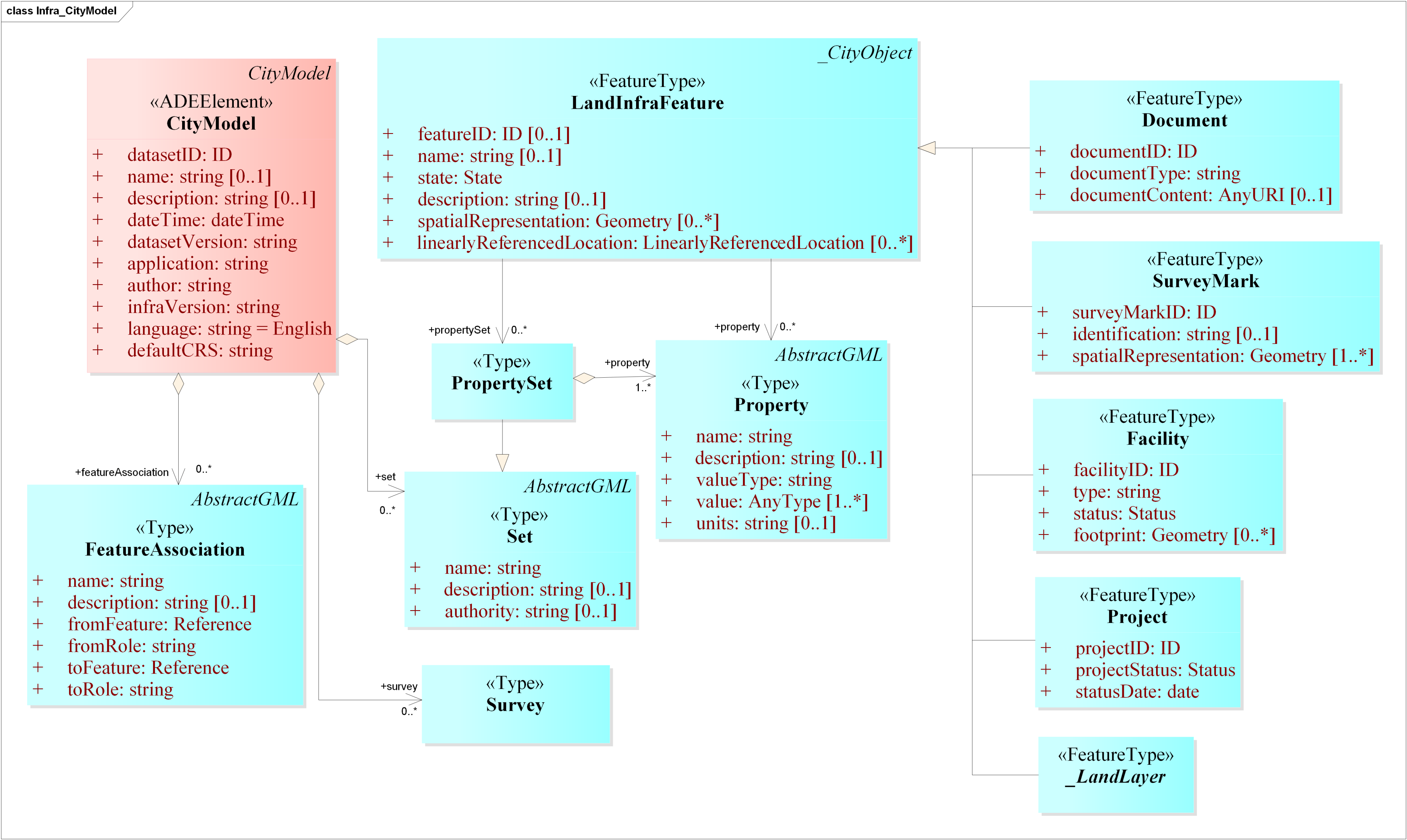
4.1. The CityGML Infra ADE
- Adding the missing LandInfra attributes to the CityGML classes that matched LandInfra classes (Cases 1 and 2);
- Adding new types that represent the LandInfra classes that do not have matching CityGML classes (Case 3 and 4);
- Adding support for the LandInfra geometry types, data types and codelists (Case 5).
4.1.1. Extending the CityGML Classes That Match LandInfra Classes
- The ID and the scope of the dataset (<infra:datasetID>);
- The metadata about the dataset (e.g., <infra:name>, <infra:dateTime> and <infra:author>);
- The associations between the features in the dataset (<infra:featureAssociation>);
- The information about the survey(s) stored in the dataset (<infra:survey>);
- The collective information about the features belonging to a particular type or authority in the dataset (<infra:set>).
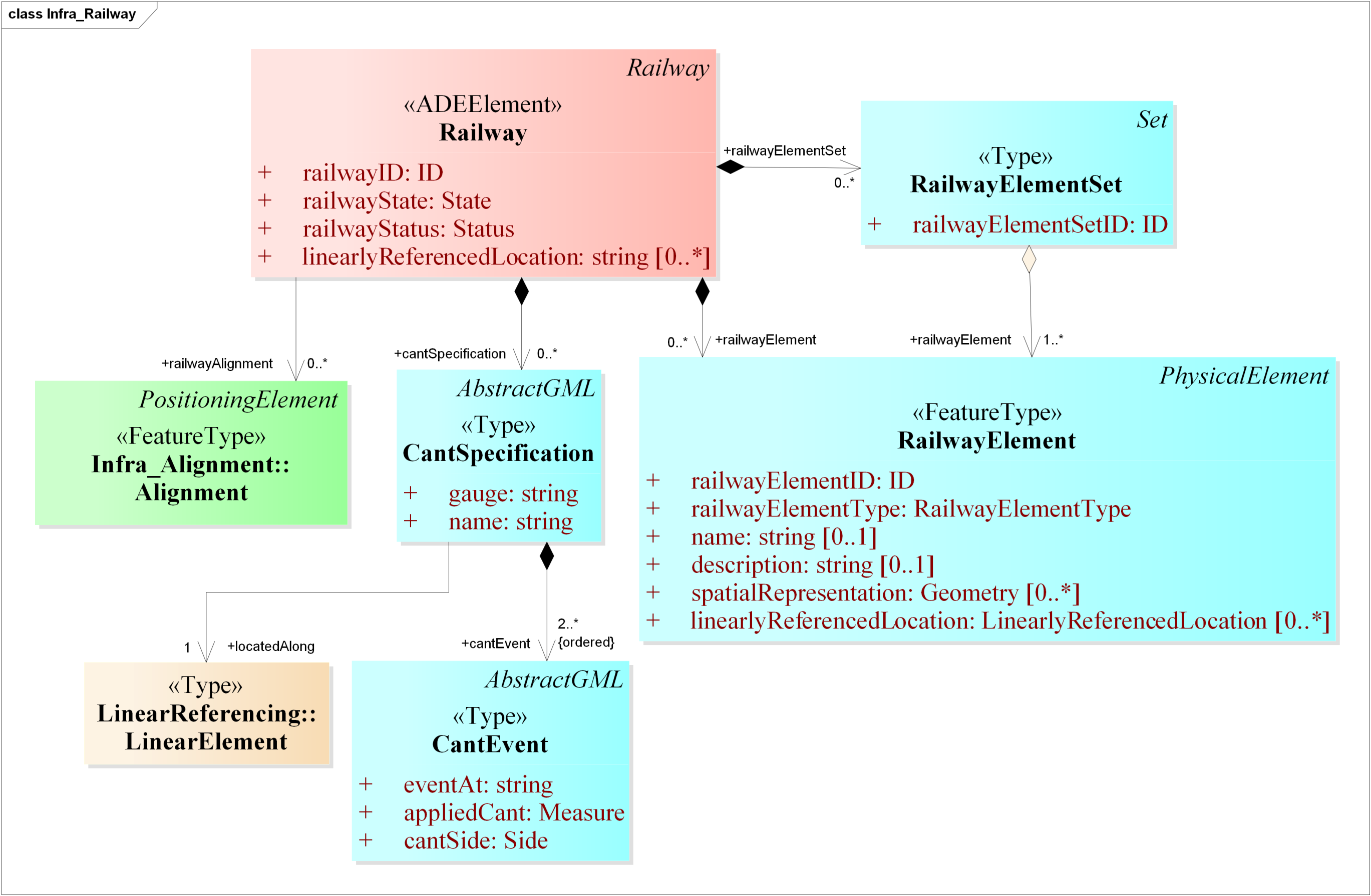
- The ID and the scope of the railway features present in the dataset (<infra:railwayID>);
- The attribute indicating if the railway feature is existing or proposed (<infra:railwayState>);
- The status to indicate where the railway feature is within its life cycle (<infra:railwayStatus>);
- The railway elements such as switches, rails, etc. present in the dataset (<infra:railwayElement>);
- The specifications of the cant (also called the superelevation) of the railway tracks present in the dataset (<infra:cantSpecification>);
- The alignments (positioning elements) used to define the geometry of the railway tracks (<infra:railwayAlignment>).
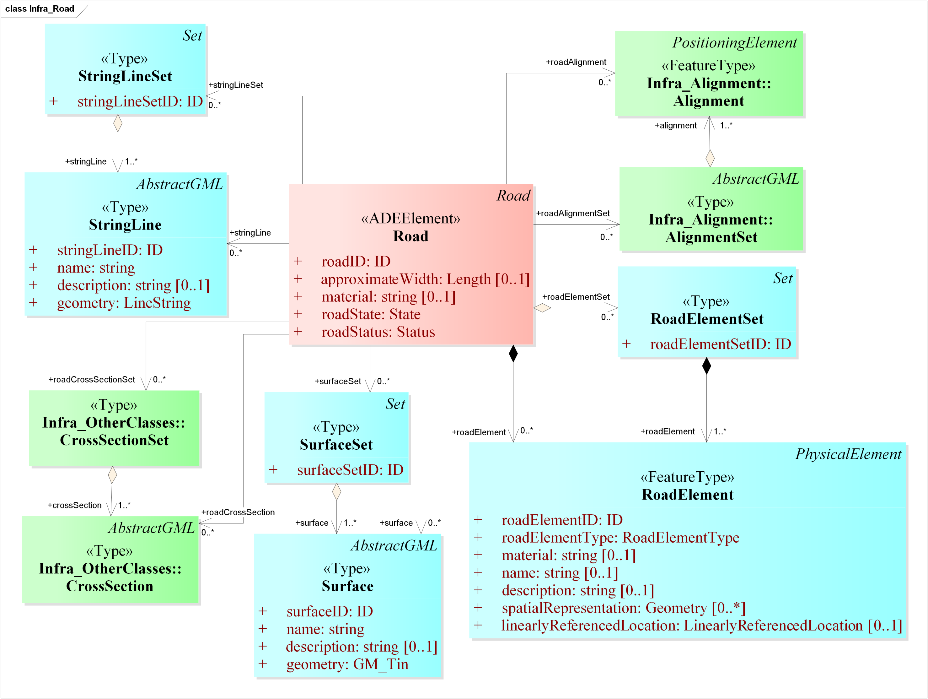
- The ID and the scope of the road features present in the dataset (<infra:roadID>);
- The estimated width of the road (<infra:approximateWidth>);
- The material of the road (<infra:material>);
- The attribute indicating if the road feature is existing or proposed (<infra:roadState>);
- The status to indicate where the road feature is within its life cycle (<infra:roadStatus>);
- The road elements such as pavements, side walks, etc. present in the dataset (<infra:roadElement>);
- The alignments (positioning elements) used to define the geometry of the roads (<infra:roadAlignment>);
- Alternative ways for representing a road from design perspective such as 3D StringLines (<infra:stringLine> aka profile views, longitudinal breaklines, long sections), and 3D surfaces (<infra:surface>), or as well as collections of these (<infra:stringLineSet> or <infra:surfaceSet>) [1];
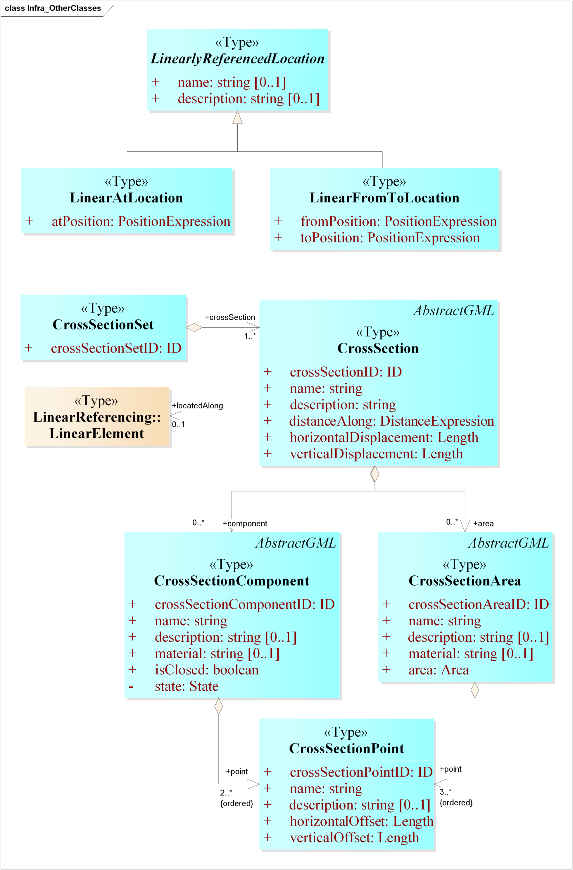
- The 2D cross section views cut across the road at a particular location along the length of the road (<infra:roadCrossSection>).
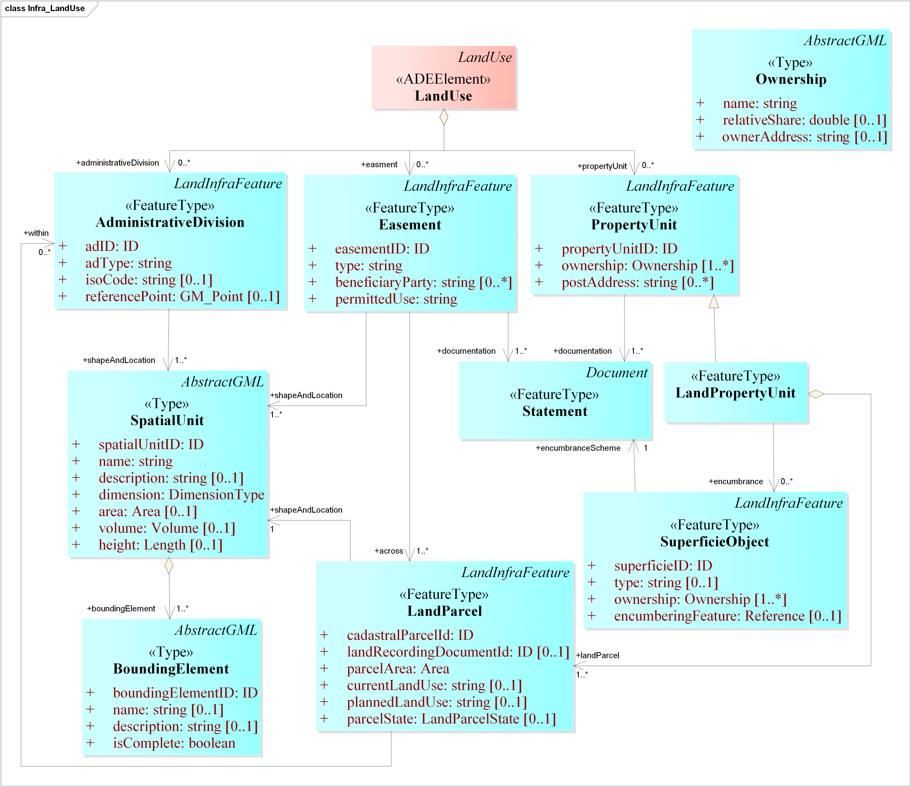
- The ID and the scope of the land division features present in the dataset;
- The type of land division. It can be public (infra:administrativeDivision) or private (infra:easement or infra:propertyUnit) in nature;
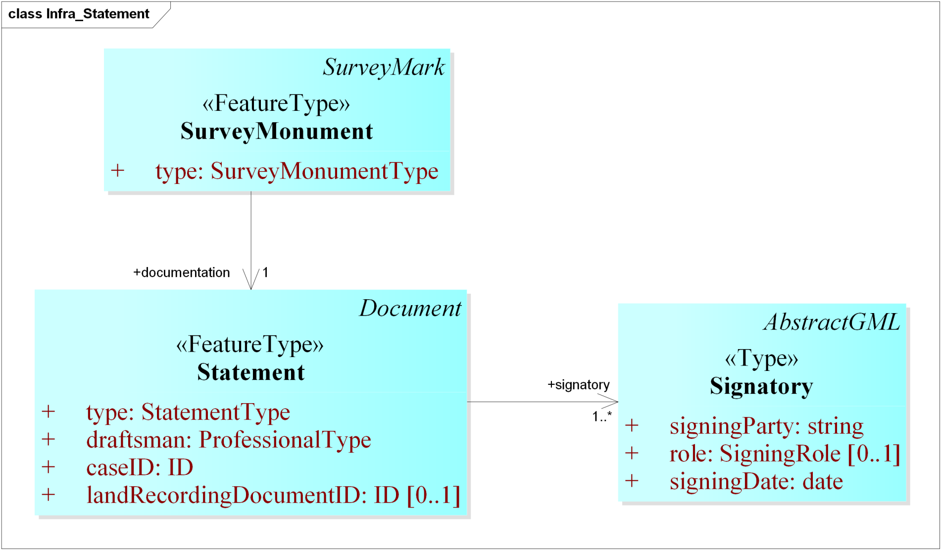
- The statement document which specifies which establishment or acquisition of the land (infra:documentation);
- The ownership rights of properties (infra:ownership);
- The cadastral parcels present in the dataset (infra:landParcel);
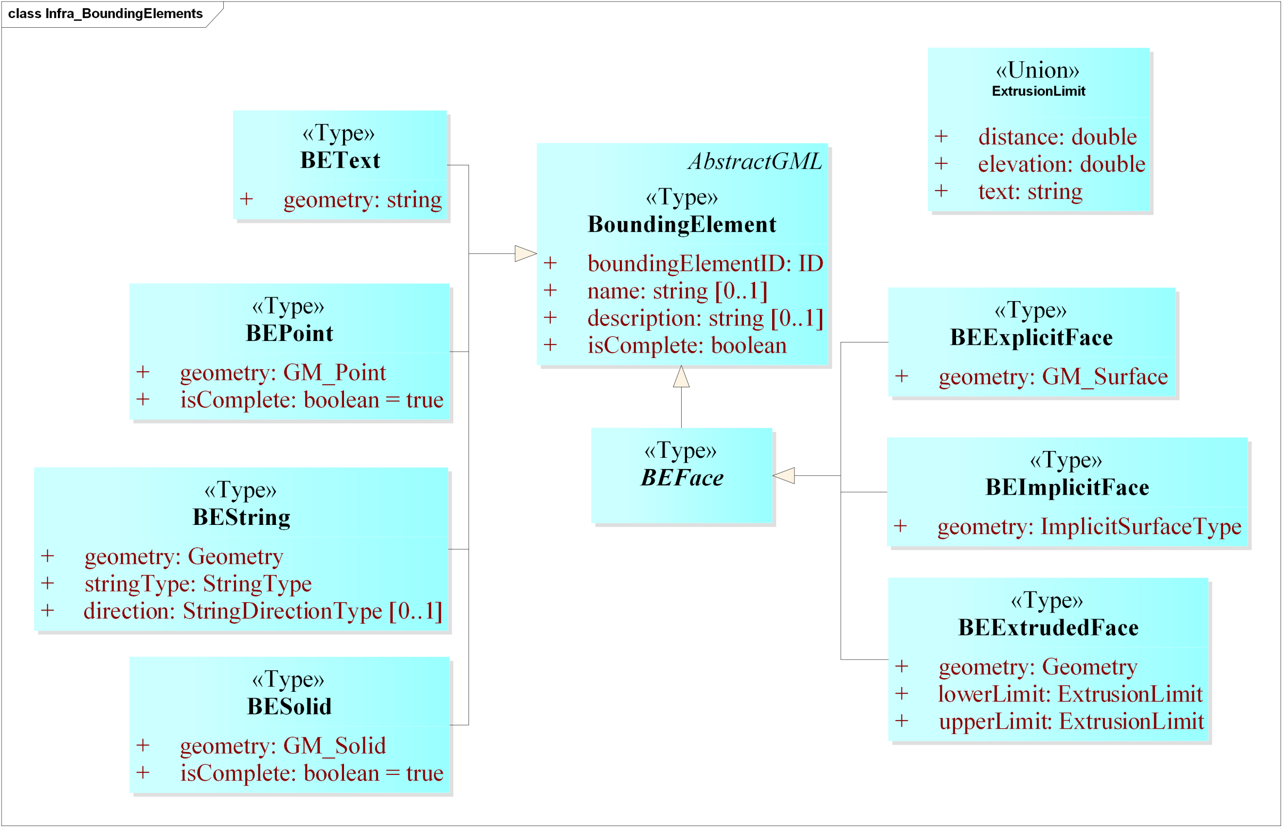
- The spatial units to define the geometry (shape and location) of the land parcels, easements, and other administrative divisions (infra:SpatialUnit);
- The bounding elements to specify the boundary of the spatial units (infra:boundingElement).
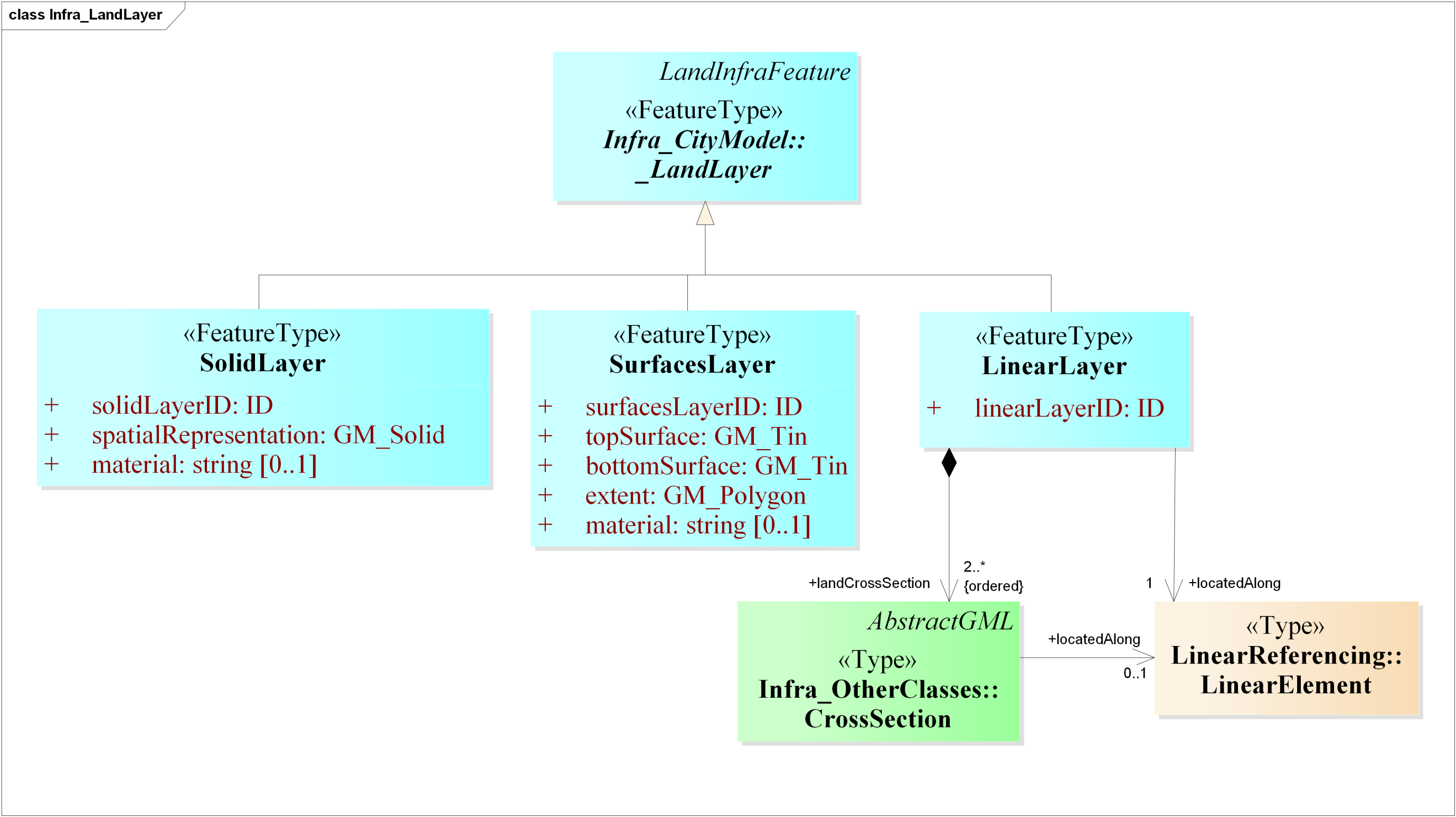
- The ID and the scope of the land surface features present in the dataset (<infra:landSurfaceID>);
- The material of the land surface (<infra:material>);
- The spatial representation of the land surface as TINs (similar to TINRelief);
- The attribute indicating if the feature is existing or proposed (<infra:state>).
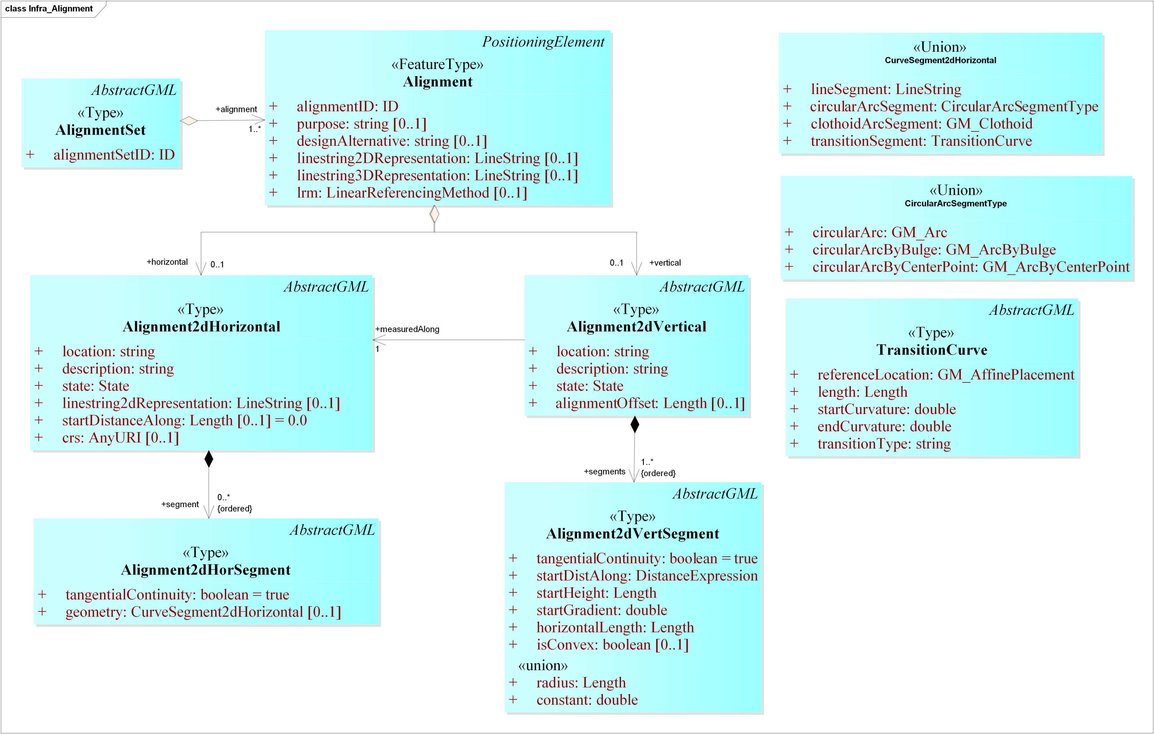
4.1.2. Adding New Feature Types for Non-Matching LandInfra Classes
- A simple 2D line string (<infra:lineString2DRepresentation>);
- A horizontal alignment (<infra:Alignment2DHorizontal>);
- A horizontal alignment with an accompanying 2D vertical long section taken along the horizontal alignment (<infra:Alignment2DVertical>);
- A 3D line string (<infra:lineString3DRepresentation>).
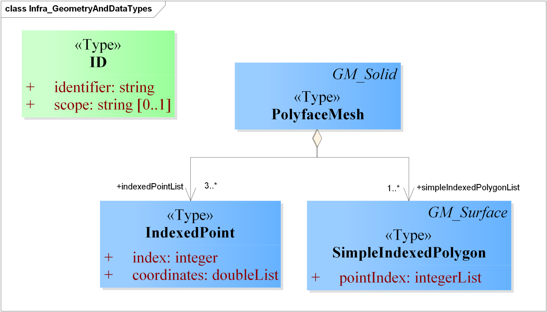
4.1.3. New Geometry Types, Data Types and Codelists
 |
5. Implementation and Testing
5.1. Software Prototypes
- citygml2infragml.py for converting original CityGML models to InfraGML.
- infragml2citygml.py for converting InfraGML models to CityGML (with Infra ADE).
5.2. Experiments and Validation
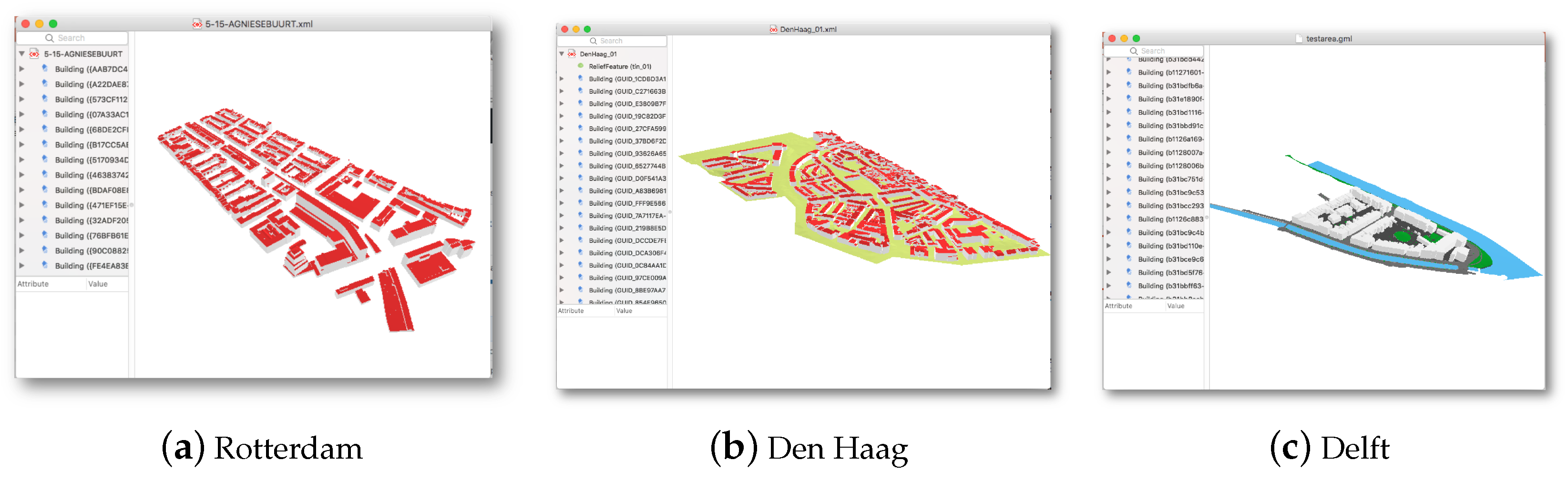
- From CityGML to InfraGML:
- (a)
- CityGML 2.0.0 LOD2 (Levels of Detail) city model of an area in Rotterdam, the Netherlands (Source: http://rotterdamopendata.nl/dataset/rotterdam-3d-bestanden).
- (b)
- CityGML 1.0.0 LOD2 models of building and terrain of an area in the Hague, the Netherlands (Source: https://data.overheid.nl/data/dataset/48265-3d-lod2-stadsmodel-2010-den-haag-citygml).
- (c)
- CityGML 2.0.0 LOD1 city model of an area of Delft, the Netherlands generated using 3dfier (https://github.com/tudelft3d/3dfier) (Source: https://3d.bk.tudelft.nl/opendata/3dfier/).
- From InfraGML to CityGML:
- (a)
- Sample InfraGML 1.0.0 datasets of land surfaces, facilities and roads.
- (b)
- 3D city models of an area in Delft, Rotterdam, and the Hague, the Netherlands generated by converting original CityGML LOD1 and LOD2 models to InfraGML using citygml2infragml.py.
6. Use Cases for the CityGML Infra ADE
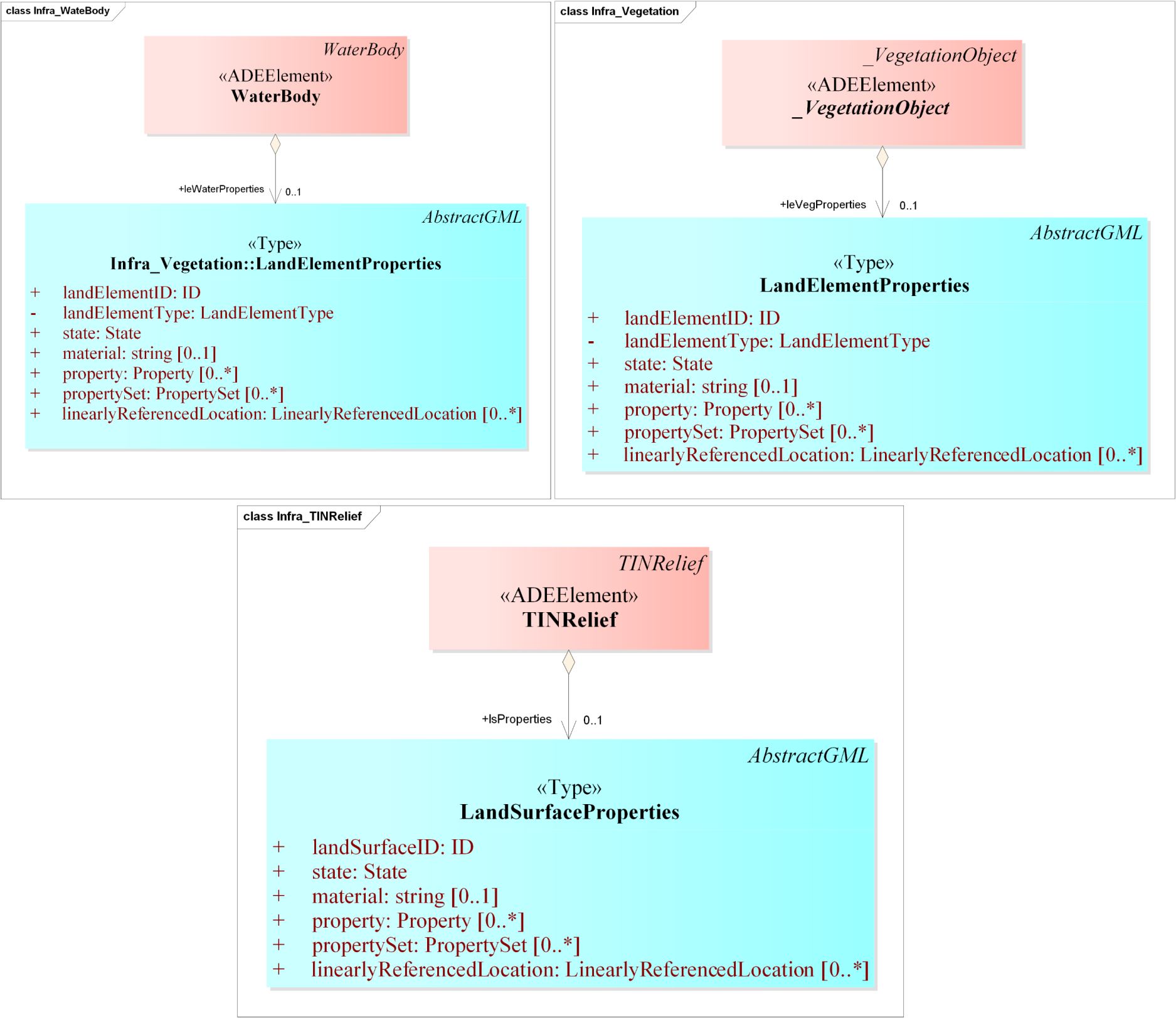
- Subsurface modellingCityGML originally does not model real-world subsurface data originating from the geological models [36], which is useful for many applications, such as infrastructural works that require excavations and soil studies. Since LandInfra has support for modelling topography (terrain) and subsurface information in its requirement class LandFeature, our Infra ADE enables the modelling of surface features (such as buildings, roads, etc.) with subsurface information in an integrated framework (see Snippet 1 below for implementation in an Infra ADE dataset). The subsurface layers can be represented in three ways in the Infra ADE: As TINs, 3D polyface mesh solids, or vertical 2D cross sections. Each subsurface layer can have an additional attribute material to specify the material of the layer. This integrated framework will not only benefit the planning and design process for surface and subsurface structure construction, but also make transparent the risk management.


- 3D cadastreCityGML lacks the capability to represent the legal extents and rights of entities within a complex, which is the core of land administration information. Extensions have been proposed to integrate this information in the data model of CityGML for the management of property rights, e.g., the CityGML Land Administration Domain Model (LADM) ADE to represent the legal ownership of buildings and their parts in CityGML in accordance with the ISO 19152-LADM [37] standard [38,39]. However, most of the available land administration research with CityGML is centred around buildings.LandInfra is more than LADM. LandInfra addresses land development in the context of activities concerning civil engineering infrastructure facilities [1]. This is achieved by modelling what is needed to account for such activities, including defining the legal entities, their boundaries, as well as identification of the signing parties [1]. LandDivision is one of the requirement classes of LandInfra. As mentioned in the LandInfra specifications, the scope of LandInfra does not include land recording and database storage. The LandInfra Standard addresses only a subset of LADM [1]. The integration of LandInfra with CityGML in our Infra ADE further enables modelling administrative divisions, cadastral information and ownership rights of condominiums, and subsurface infrastructure such as underground tunnels (Snippet 2).


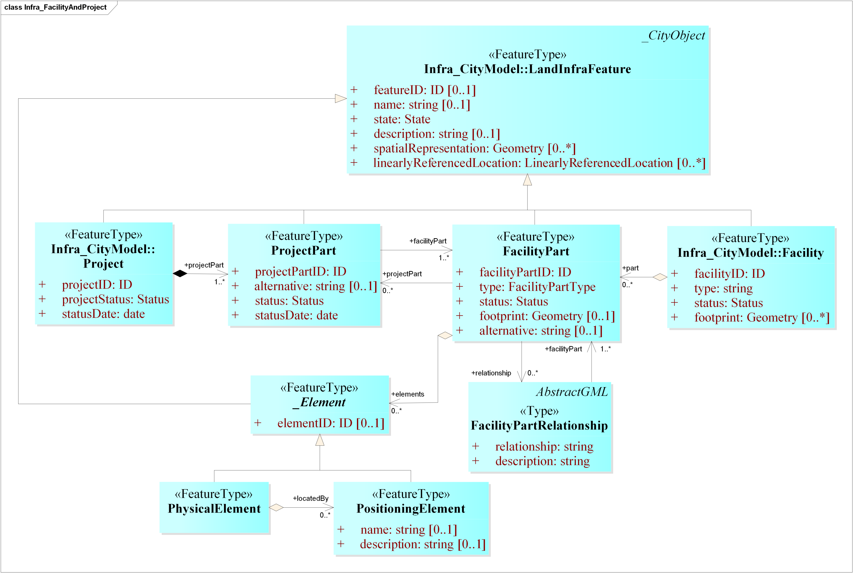
- Urban facility managementCurrently, most of the research related to facility management is confined to buildings. For instance, Kim et al. [40] implemented the CityGML Indoor ADE to implement indoor space and indoor facility management applications for buildings. Similarly, the CityGML Computer Aided Facility Management (CAFM) ADE was developed by Moshrefzadeh et al. [41] to integrate detailed geometric and semantic information on the outer shell of the buildings for applications like cleaning management, and cost planning and management.In LandInfra, a facility includes buildings and other infrastructure, such as roads, railways, runways, waste water system, bridge, utilities (pipelines) etc. [1]. The integration of LandInfra with CityGML in our Infra ADE enables effective management of all the aforementioned facilities in CityGML. Each facility, whether a building or a road, has a life cycle, including planning, design, construction, maintenance, operation, and termination phases. Furthermore, a facility may be broken down into parts (FacilityPart), e.g., a shopping mall may include buildings, roads, site, drainage, water distribution and waste water [1]. Any activity such as the design or construction related to a facility (or its parts) is managed through projects (Project/ProjectPart). The CityGML Infra ADE dataset can include any number of projects to store the status of the facility project (projectStatus) and the date on which the status value is valid (statusDate) to make the dataset more manageable (Snippet 3).


- SurveyingSurvey data can be used as a reliable data source at all the stages of the life cycle of a building or other features. Designers of architectural and design projects, armed with accurate site data, can work with reduced overall commercial risk, and with greater certainty. CityGML does not provide a way to store survey data in a structured way, but LandInfra has a requirement class Survey outlining the specifications to store such data. Because of this, the integration of LandInfra with CityGML in our Infra ADE enables effective management of survey metadata in CityGML, e.g., survey type and its purpose, surveyor information, and so on. Further, it is possible to store information about the survey observation points, accuracy information, equipments or sensors used, and the results.

- Asset managementAsset management can be summarised as a systematic approach to the process of maintaining, upgrading and operating physical assets in a cost-effective way for both short- and long-term planning [42]. For municipalities and regional governments asset management is a crucial element of day-to-day operations. Within asset management, the maintenance of roads and transportation networks is key to keeping traffic moving smoothly and safely on a daily basis. Road maintenance includes activities such as smoothness control/de-icing, repairs, closures, milestone maintenance and traffic city furniture replacement [17].While CityGML has support for Levels of Detail (LODs), it only supports line representation at LOD0 and polygon representation at LOD1–LOD4. InfraGML supports four representations for roads: Solid, faceted (triangular) surfaces, lines running longitudinally and 2D views cut perpendicular to a road’s centreline. It is also possible to model the cross-section of a road, which is valuable for repair projects. Furthermore, CityGML has support for railways in its Transportation module, but it has little support and almost no documentation. It is also unclear how to exactly model a railway in CityGML, as it is also mentioned as being a part of the Tunnel and Bridge modules. With InfraGML, there is a dedicated class for railways and this has support for 3D railway elements and track geometry including superelevation (cant). Snippet 5 summarises the potential additional elements from LandInfra that can enhance CityGML data for road asset management.


- Urban environmental analysisThe added value of integrating CityGML and LandInfra in our Infra ADE can also be seen in urban applications such as estimating the level of noise exposure on buildings, or how much solar irradiation a building will receive. Unlike CityGML, LandInfra explicitly models the materials of road surfaces and terrain, geometry and semantics of railways, type of road elements (pavements, hard shoulders, soft shoulders etc.), construction materials of buildings, and information about the observation/measurement points to name a few. Such information is useful for environmental applications such as urban noise and flood mapping. We have added all these elements in the Infra ADE to supplement environmental analysis using CityGML. The previous snippet of XML Snippet 5 contains elements that can be useful in urban environmental analysis.


7. Conclusions and Future Work
Author Contributions
Funding
Conflicts of Interest
Abbreviations
| ADE | Application Domain Extension |
| BIM | Building Information Modelling |
| FME | Feature Manipulation Engine |
| GIS | Geographical Information Systems |
| GML | Geography Markup Language |
| IFC | Industry Foundation Classes |
| ISO | International Standards Organization |
| JSON | JavaScript Object Notation |
| LOD | Level Of Detail |
| OGC | Open Geospatial Consortium |
| TIN | Triangulated Irregular Network |
| UML | Unified Modelling Language |
| XML | eXtensible Markup Language |
Appendix A


References
- OGC. Land and Infrastructure Conceptual Model Standard. Doc. No. 15-111r1; OGC: Wayland, MA, USA, 2016. [Google Scholar]
- OGC. City Geography Markup Language (CityGML) Encoding Standard 2.0.0. Doc. No. 12–019; OGC: Wayland, MA, USA, 2012. [Google Scholar]
- OGC. Geography Markup Language (GML) Implementation Specifications Version 3.1.1 Doc. No. 03-105r1; OGC: Wayland, MA, USA, 2004. [Google Scholar]
- Brink, L.; Stoter, J.; Zlatanova, S. UML-Based Approach to Developing a CityGML Application Domain Extension. Trans. GIS 2013, 17, 920–942. [Google Scholar] [CrossRef]
- Kumar, K.; Ledoux, H.; Stoter, J. Compactly representing massive terrain models as TINs in CityGML. Trans. GIS 2018, 22, 1152–1178. [Google Scholar] [CrossRef] [PubMed]
- Biljecki, F.; Kumar, K.; Nagel, C. CityGML Application Domain Extension (ADE): Overview of developments. Open Geospat. Data Softw. Stand. 2018, 3, 13. [Google Scholar] [CrossRef]
- Kumar, K.; Ledoux, H.; Commandeur, T.J.F.; Stoter, J.E. Modelling urban noise in CityGML ADE: Case of the Netherlands. ISPRS Ann. Photogramm. Remote Sens. Spat. Inf. Sci. 2017, IV-4/W5, 73–81. [Google Scholar] [CrossRef]
- Agugiaro, G.; Benner, J.; Cipriano, P.; Nouvel, R. The energy application domain extension for CityGML: Enhancing interoperability for urban energy simulations. Open Geospat. Data Softw. Stand. 2018, 3, 2. [Google Scholar] [CrossRef]
- Labetski, A.; Kumar, K.; Ledoux, H.; Stoter, J. A metadata ADE for CityGML. Open Geospat. Data Softw. Stand. 2018, 3, 16. [Google Scholar] [CrossRef]
- LandXML.org. LandXML-1.2. 2016. Available online: http://www.landxml.org/About.aspx (accessed on 30 March 2019).
- Lemmen, C.; van Oosterom, P.; Kalantari, M.; Unger, E.M.; Teo, C.H.; de Zeeuw, K. Further standardization in land administration. In Proceedings of the 2017 World Bank Conference on Land and Poverty: Responsible Land Governance—Towards an Evidence-Based Approach, Washington, DC, USA, 20–24 March 2017; pp. 20–24. [Google Scholar]
- Cagdas, V.; Kara, A.; van Oosterom, P.; Lemmen, C.; Işıkdağ, Ü.; Kathmann, R.; Stubkjær, E. An initial design of ISO 19152: 2012 LADM based valuation and taxation data model. In Proceedings of the 11th 3D Geoinfo Conference, Athens, Greece, 20–21 October 2016; pp. 145–154. [Google Scholar]
- van Oosterom, P.; Lemmen, C.; Thompson, R.; Janečka, K.; Zlatanova, S.; Kalantari, M. Cadastral Information Modelling. In Best Practices 3D Cadastres: Extended Version; van Oosterom, P., Ed.; International Federation of Surveyors (FIG): Copenhagen, Danmark, 2018; pp. 95–132. [Google Scholar]
- Kalogianni, E.; Dimopoulou, E.; Quak, W.; van Oosterom, P. LADM and INTERLIS as a perfect match for 3D cadastre. ISPRS-Int. Arch. Photogramm. Remote Sens. Spat. Inf. Sci. 2017, XLII-4/W7, 23–26. [Google Scholar] [CrossRef]
- Kara, A.; Çağdaş, V.; Lemmen, C.; Işikdağ, Ü.; van Oosterom, P.; Stubkjær, E. Supporting Fiscal Aspect of Land Administration through a LADM-Based Valuation Information Model. In Proceedings of the 19th Annual World Bank Conference on Land and Poverty 2018: Land Governance in an Interconnected World, Land Governance in an Interconnected World, Washington, DC, USA, 19–23 March 2018. [Google Scholar]
- Stubkjær, E.; Paasch, J.M.; Cagdas, V.; Oosterom, P.V.; Simmons, S.; Paulsson, J.; Lemmen, C. International Code List Management—The Case of Land Administration. In Proceedings of the 7th International FIG Workshop on the Land Administration Domain Model, Zagreb, Croatia, 11–13 April 2018; pp. 223–244. [Google Scholar]
- Labetski, A.; van Gerwen, S.; Tamminga, G.; Ledoux, H.; Stoter, J. A proposal for an improved transportation model in CityGML. ISPRS Ann. Photogramm. Remote Sens. Spat. Inf. Sci. 2018, XLII-4, 89–96. [Google Scholar] [CrossRef]
- Niestroj, M.G.; McMeekin, D.A.; Helmholz, P.; Kuhn, M. A proposal to use semantic web technologies for improved road network information exchange. ISPRS Ann. Photogramm. Remote Sens. Spat. Inf. Sci. 2018, 4, 147–154. [Google Scholar] [CrossRef]
- Niestroj, M.G.; McMeekin, D.A.; Helmholz, P. Overview of standards towards road asset information exchange. Int. Arch. Photogramm. Remote Sens. Spat. Inf. Sci. 2018, 42, 443–450. [Google Scholar] [CrossRef]
- Malmkvist, M.; Axelsson, P.; Wikström, L.; Bergman, O.; Nilsson, A.; Granberg, S.; Jensen, J.; Häggström, E.; Sigfrid, J.; Karlsson, K. Alignment Deployment. Implementation Report. Verification IFC Alignment and InfraGML; Technical Report; Nordic Project Team, BuildingSMART: Hertfordshire, UK, 2017. [Google Scholar]
- UIC. RailTopoModel. 2016. Available online: http://www.railtopomodel.org (accessed on 28 March 2019).
- Devys, E. Rail Infrastructure: RailTopoModel and LandInfra Interoperability. In Proceedings of the 9th RailTopoModel Conference, Paris, France, 22 May 2018; Available online: http://rtm.uic.org/wp-content/uploads/2018/06/10-ISN-18.063-10-Rail-infra-RailTopoModel-LandInfra-Interoperability-220518.pptx (accessed on 28 March 2019).
- Pouliot, J.; Larrivée, S.; Ellul, C.; Boudhaim, A. Exploring schema matching to compare geospatial standards: Application to underground utility networks. Int. Arch. Photogramm. Remote Sens. Spat. Inf. Sci. 2018, 42, 157–164. [Google Scholar] [CrossRef]
- OGC. OGC Underground Infrastructure Concept Study Engineering Report. Document No. OGC 17-048; OGC: Wayland, MA, USA, 2017. [Google Scholar]
- Becker, T.; Nagel, C.; Kolbe, T.H. Integrated 3D modeling of multi-utility networks and their interdependencies for critical infrastructure analysis. In Advances in 3D Geo-Information Sciences; Springer: Berlin, Germany, 2011; pp. 1–20. [Google Scholar]
- OGC. PipelineML Conceptual and Encoding Model Standard; OGC: Wayland, MA, USA, 2016. [Google Scholar]
- Blanchet, C.; Castaing, C.; Beaufils, M.; Emmanuel, D. GeoBIM (MINnD) Use Case on an Infrastructure Acoustic Study: Feedback on the Use of CityGML and InfraGML. 2017. Available online: https://portal.opengeospatial.org/files/?artifact_id=75554 (accessed on 28 March 2019).
- Rajabifard, A.; Atazadeh, B.; Kalantari, M. A critical evaluation of 3D spatial information models for managing legal arrangements of multi-owned developments in Victoria, Australia. Int. J. Geogr. Inf. Sci. 2018, 32, 2098–2122. [Google Scholar] [CrossRef]
- BuildingSMART. BuildingSMART for Infrastructure. 2015. Available online: http://www.buildingsmart-tech.org/infrastructure/projects (accessed on 30 April 2019).
- Kumar, K.; Labetski, A.; Arroyo Ohori, K.; Ledoux, H.; Stoter, J. The LandInfra standard and its role in solving BIM-GIS quagmire. Open Geospat. Data Softw. Stand. 2019. under review. [Google Scholar]
- Safe Software. FME 2019.0. 2019. Available online: https://www.safe.com (accessed on 15 May 2019).
- KIT. FZK Viewer 5.1. 2019. Available online: https://www.iai.kit.edu/1302.php (accessed on 30 April 2019).
- El-Mekawy, M.; Östman, A.; Shahzad, K. Towards Interoperating CityGML and IFC Building Models: A Unified Model Based Approach. In Advances in 3D Geo-Information Sciences; Springer: Berlin, Germany, 2011; pp. 73–93. [Google Scholar]
- Ledoux, H. On the validation of solids represented with the international standards for geographic information. Comput.-Aided Civ. Infrastruct. Eng. 2013, 28, 693–706. [Google Scholar] [CrossRef]
- Ledoux, H. val3dity: Validation of 3D GIS primitives according to the international standards. Open Geospat. Data Softw. Stand. 2018, 3, 1. [Google Scholar] [CrossRef]
- Zobl, F.; Chmelina, K.; Faber, R.; Kooijman, J.; Marschallinger, R.; Stoter, J. Multidimensional aspects of GeoBIM data: New standards needed. In Mathematical Geosciences at the Crossroads of Theory and Practice, Proceedings of the IAMG2011 Conference, Salzburg, Austria, 5–9 September 2011; International Association for Mathematical Geosciences (IAMG): Houston, TX, USA, 2011; pp. 1–14. [Google Scholar]
- ISO. ISO 19152:2012 Geographic Information—Land Administration Domain Model (LADM); ISO: Geneva, Switzerland, 2012. [Google Scholar]
- Rönsdorff, C.; Wilson, D.; Stoter, J. Integration of land administration domain model with CityGML for 3D Cadastre. In Proceedings of the 4th International Workshop on 3D Cadastres, Dubai, UAE, 9–11 November 2014. [Google Scholar]
- Góźdź, K.; Pachelski, W.; Van Oosterom, P.; Coors, V. The possibilities of using CityGML for 3D representation of buildings in the cadastre. In Proceedings of the 4th International Workshop on 3D Cadastres, Dubai, UAE, 9–11 November 2014; pp. 9–11. [Google Scholar]
- Kim, Y.; Kang, H.; Lee, J. Developing CityGML indoor ADE to manage indoor facilities. In Innovations in 3D Geo-Information Sciences; Springer: Berlin, Germnay, 2014; pp. 243–265. [Google Scholar]
- Moshrefzadeh, M.; Donaubauer, A.; Kolbe, T.H. A CityGML-based Façade Information Model for Computer Aided Facility Management. In Proceedings of the Bridging Scales-Skalenübergreifende Nah-und Fernerkundungsmethoden, 35. Wissenschaftlich-Technische Jahrestagung der DGPF, Cologne, Germany, 16–18 March 2015. [Google Scholar]
- McNeil, S.; Tischer, M.; DeBlasio, A. Asset management: What is the fuss? Transp. Res. Rec. J. Transp. Res. Board 2000, 1729, 21–25. [Google Scholar] [CrossRef]
- Yao, Z.; Kolbe, T.H. Dynamically extending spatial databases to support CityGML application domain extensions using graph transformations. In Proceedings of the Kulturelles Erbe Erfassen und Bewahren-Von der Dokumentation zum Virtuellen Rundgang, 37. Wissenschaftlich-Technische Jahrestagung der DGPF, Würzburg, Germany, 8–10 March 2017; pp. 316–331. [Google Scholar]
- Yao, Z.; Nagel, C.; Kunde, F.; Hudra, G.; Willkomm, P.; Donaubauer, A.; Adolphi, T.; Kolbe, T.H. 3DCityDB-a 3D geodatabase solution for the management, analysis, and visualization of semantic 3D city models based on CityGML. Open Geospat. Data Softw. Stand. 2018, 3, 5. [Google Scholar] [CrossRef]
- Nagel, C. citygml4j: The open Source Java API for CityGML. 2015. Available online: https://github.com/citygml4j/citygml4j (accessed on 30 April 2019).
- Target, S. The Rise and Rise of JSON. 2017. Available online: https://twobithistory.org/2017/09/21/the-rise-and-rise-of-json.html (accessed on 28 March 2019).
- Ledoux, H.; Arroyo Ohori, K.; Kumar, K.; Dukai, B.; Labetski, A.; Vitalis, S. CityJSON: A compact and easy-to-use encoding of the CityGML data model. Open Geospat. Data Softw. Stand. 2019. accepted for publication. [Google Scholar]


| # | Class | Summary | InfraGML Part |
|---|---|---|---|
| 1 | LandInfra | Mandatory core with dataset information and common types | 0 |
| 2 | Facility | Collection of buildings, civil engineering works and their siteworks | 2 |
| 3 | Project | Activity related to the improvement of a facility | 2 |
| 4 | Alignment | Positioning element for locating physical elements | 3 |
| 5 | Road | Roads with 3D elements | 4 |
| 6 | Railway | 3D railway elements and track geometry | 5 |
| 7 | Survey | Information related to surveys, e.g., equipment, results, etc. | 6 |
| 8 | LandFeature | Whether natural or man-made, in the surface or subsurface | 1 |
| 9 | LandDivision | Public (political, judicial, or executive) or private land divisions | 7 |
| 10 | Condominium | Ownership of private and public units in a multi-unit building | 7 |
| # | LandInfra | CityGML | Description |
|---|---|---|---|
| 1 | LandInfraDataset (M) | CityModel | Aggregations of features with optional metadata. |
| 2 | Feature | _CityObject | The base classes for all the features. Both are derived from GML class _Feature, but LI::Feature is a concrete class whereas CG::_CityObject is abstract; they are only conceptually similar. |
| 3 | Document | — | No matching semantic class is available. |
| 4 | SurveyMark | — | No matching semantic class is available. |
| 5 | Project (M) | — | No matching semantic class is available. |
| 6 | Facility (M) | _Site | Both include buildings and other civil engineering structures, such as tunnels and bridges, but LI::Facility also defines runways, pipelines and water systems, which are not present in CityGML. However, LI::Facility is a concrete class whereas CG::_Site is abstract; they are only conceptually similar. |
| 7 | FacilityPart | — | No matching semantic class is available. |
| 8 | Building | Building | In LandInfra it is a subclass of LI::FacilityPart, whereas in CityGML it is a part of the CG::Building module. |
| 9 | LandFeature (M) | — | No matching semantic class is available. |
| 10 | LandElement | WaterBody/PlantCover/TINRelief | The correspondence depends on the value of a LI::LandElement’s elementType, which can be waterBody, vegetation or landForm, as defined in the codelist LandElementType. |
| 11 | LandSurface | TINRelief | LI::LandSurface models terrain as a TIN, much like CG::TINRelief. |
| 12 | _LandLayer | — | No matching semantic class is available. |
| 13 | Alignment (M) | — | No matching semantic class is available. |
| 14 | Road (M) | Road | In the Transportation module in CityGML and in the Facility requirement class in LandInfra. CityGML focuses on polygon representations with the possibility to include lines as well, while LandInfra focuses on lines and surfaces (i.e., TINs). |
| 15 | Railway (M) | Railway | In the Transportation module in CityGML and in the Facility requirement class in LandInfra. LandInfra provides many more components that can be modelled. |
| 16 | LandDivision (M) | LandUse | CG::LandUse represents divisions according to specific land uses, whereas LI::LandDivision has richer semantics and is further divided according to political, judicial, or executive views, ownership, rights, and so on. |
| 17 | CondominiumBuilding (M) | — | No matching semantic class is available. |
| 18 | Survey (M) | — | No matching semantic class is available. |
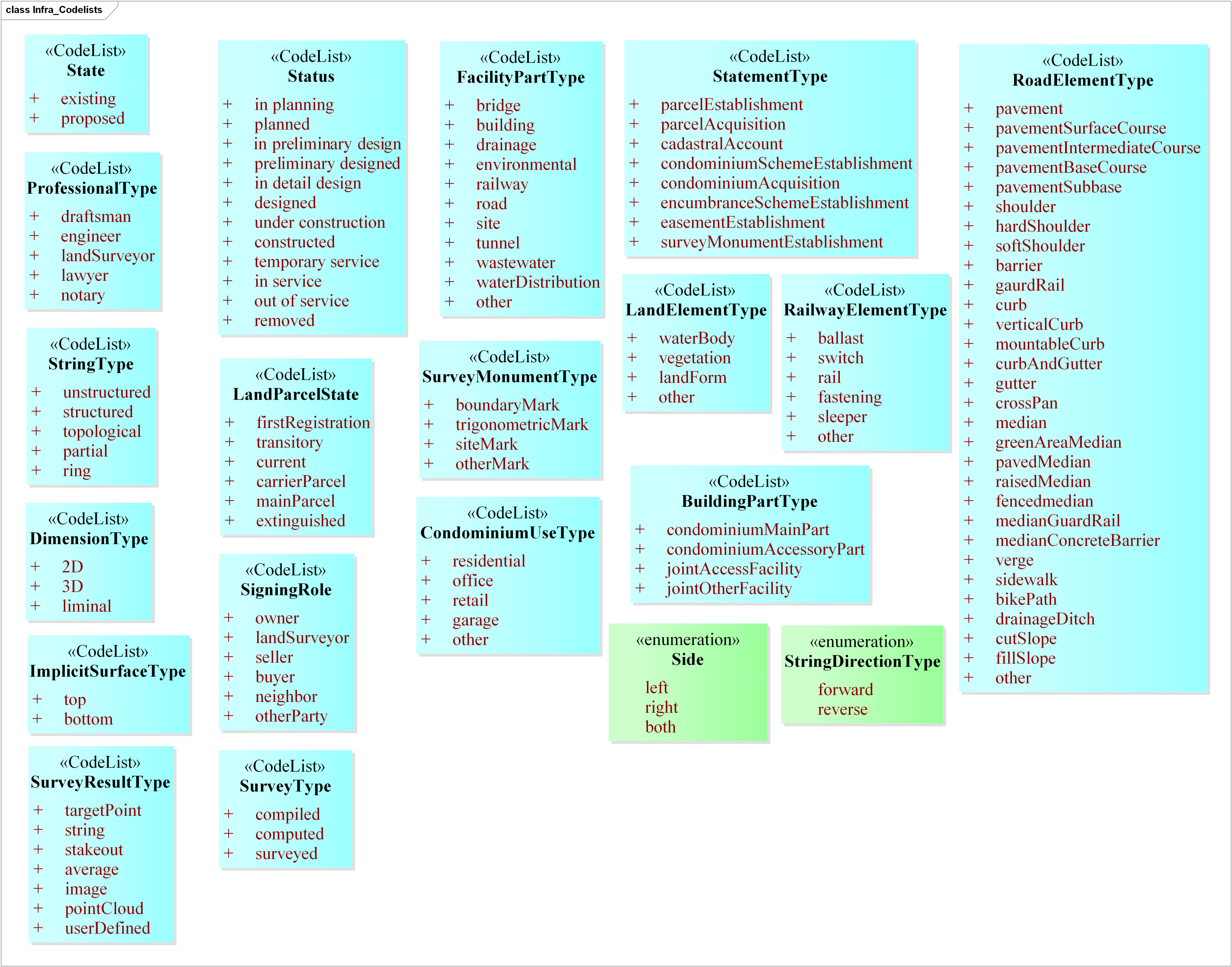
| # | Codelist | Description |
|---|---|---|
| 1 | State | Whether an object is existing or proposed. |
| 2 | Status | Life cycle stage of an object, e.g., planned, under construction, etc. |
| 3 | ProfessionalType | Position of the person in charge of the land development and infrastructure project e.g., draftsman, engineer, surveyor, etc. |
| 4 | FacilityPartType | e.g., building, road, etc. |
| 5 | LandElementType | e.g., vegetation, terrain, etc. |
| 6 | RoadElementType | e.g., pavement, gutter, etc. |
| 7 | RailwayElementType | e.g., switch, rail, etc. |
| 8 | LandParcelState | e.g., main parcel or carrier parcel, etc. |
| 9 | SurveyMonumentType | e.g., boundary marker, observation point of geodetic significance, etc. |
| 10 | StatementType | Statement that is signed to establish the interest in the land. |
| 11 | SigningRole | Role a signing party plays, e.g., owner, buyer, seller, etc. |
| 12 | CondominiumUseType | e.g., residential, office, etc. |
| 13 | BuildingPartType | e.g., the main part to which the postal address refers to, or a secondary part like the basement of a shop, etc. |
| 14 | StringType | Geometric string representation of bounding element BEString. |
| 15 | DimensionType | Dimension of a spatial unit. Depending on the value, a spatial unit can include attributes such as area, volume and height. |
| 16 | ImplicitSurfaceType | Top or bottom surface of a spatial unit for the bounding element BEImplicitFace. |
| 17 | SurveyType | e.g., compiled, computed or actually surveyed, etc. |
| 18 | SurveyResultType | e.g., point, point cloud, image, etc. |
© 2019 by the authors. Licensee MDPI, Basel, Switzerland. This article is an open access article distributed under the terms and conditions of the Creative Commons Attribution (CC BY) license (http://creativecommons.org/licenses/by/4.0/).
Share and Cite
Kumar, K.; Labetski, A.; Ohori, K.A.; Ledoux, H.; Stoter, J. Harmonising the OGC Standards for the Built Environment: A CityGML Extension for LandInfra. ISPRS Int. J. Geo-Inf. 2019, 8, 246. https://doi.org/10.3390/ijgi8060246
Kumar K, Labetski A, Ohori KA, Ledoux H, Stoter J. Harmonising the OGC Standards for the Built Environment: A CityGML Extension for LandInfra. ISPRS International Journal of Geo-Information. 2019; 8(6):246. https://doi.org/10.3390/ijgi8060246
Chicago/Turabian StyleKumar, Kavisha, Anna Labetski, Ken Arroyo Ohori, Hugo Ledoux, and Jantien Stoter. 2019. "Harmonising the OGC Standards for the Built Environment: A CityGML Extension for LandInfra" ISPRS International Journal of Geo-Information 8, no. 6: 246. https://doi.org/10.3390/ijgi8060246
APA StyleKumar, K., Labetski, A., Ohori, K. A., Ledoux, H., & Stoter, J. (2019). Harmonising the OGC Standards for the Built Environment: A CityGML Extension for LandInfra. ISPRS International Journal of Geo-Information, 8(6), 246. https://doi.org/10.3390/ijgi8060246