Semantics-Constrained Advantageous Information Selection of Multimodal Spatiotemporal Data for Landslide Disaster Assessment

 , ,
, ,
Abstract
1. Introduction
2. Methodology
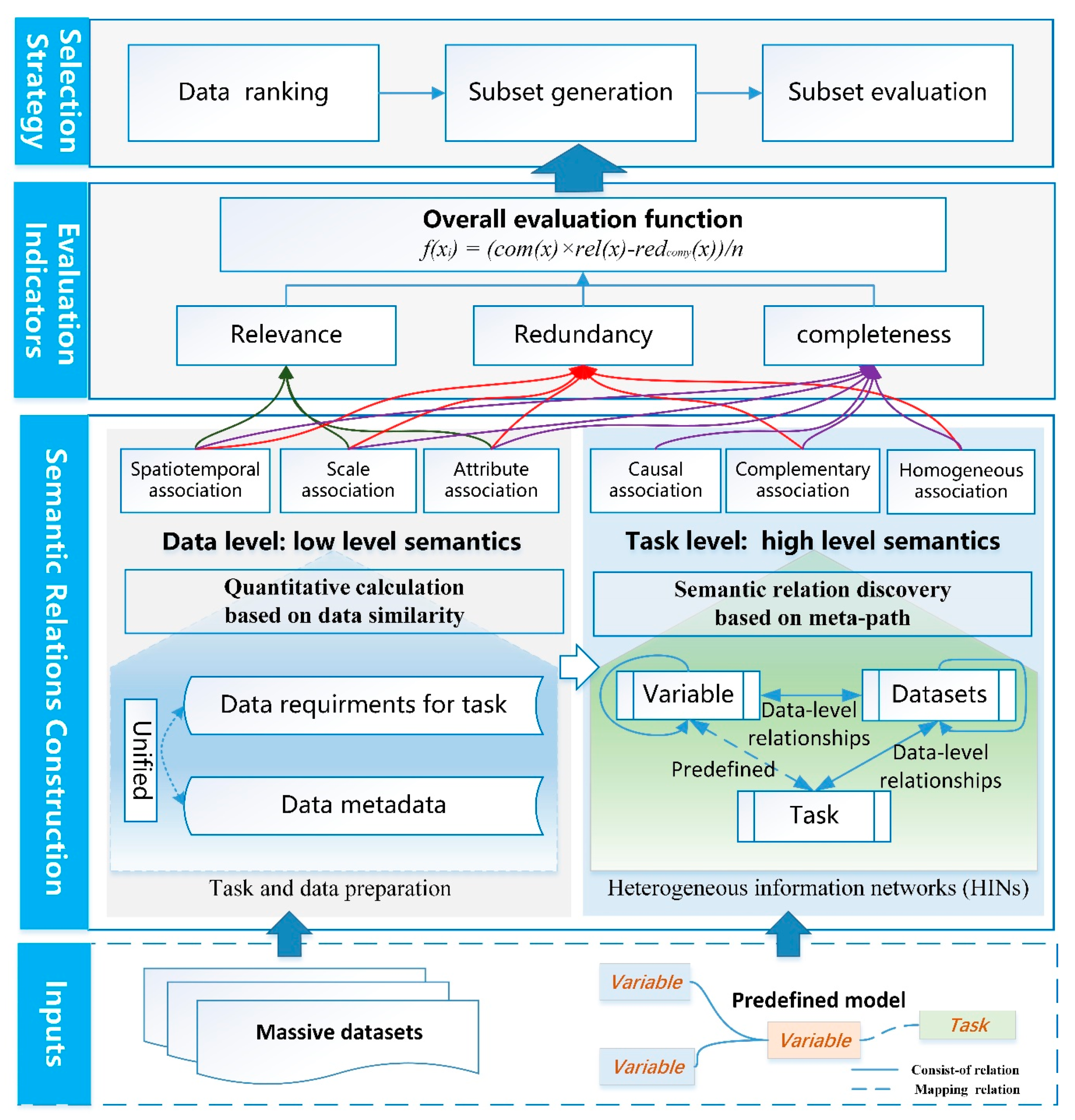
2.1. Framework of the Methodology
2.2. Construction of Multidimensional Semantic Relationships
2.2.1. Unified Description of Multiple-Association Relationships
2.2.2. Calculation of Data-Level Relationships Based on Data Similarity
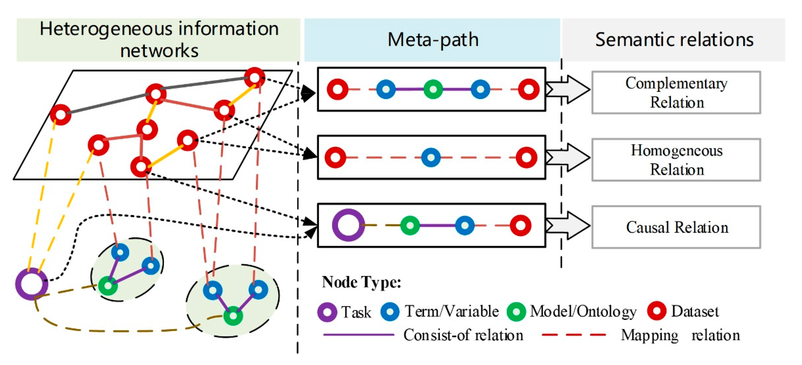
2.2.3. Task-Level Relationship Discovery Based on Meta-Paths
 , which represents a path of type .
 , which represents a path of type , where the relationships of r1 and r2 do not belong to the consist-of relationship at the same time.
 , which represents a path of type .
2.3. Semantics-Concerned Evaluation Indicators
2.4. Semantics-Constrained Advantageous Information Selection Strategy
3. Case Study
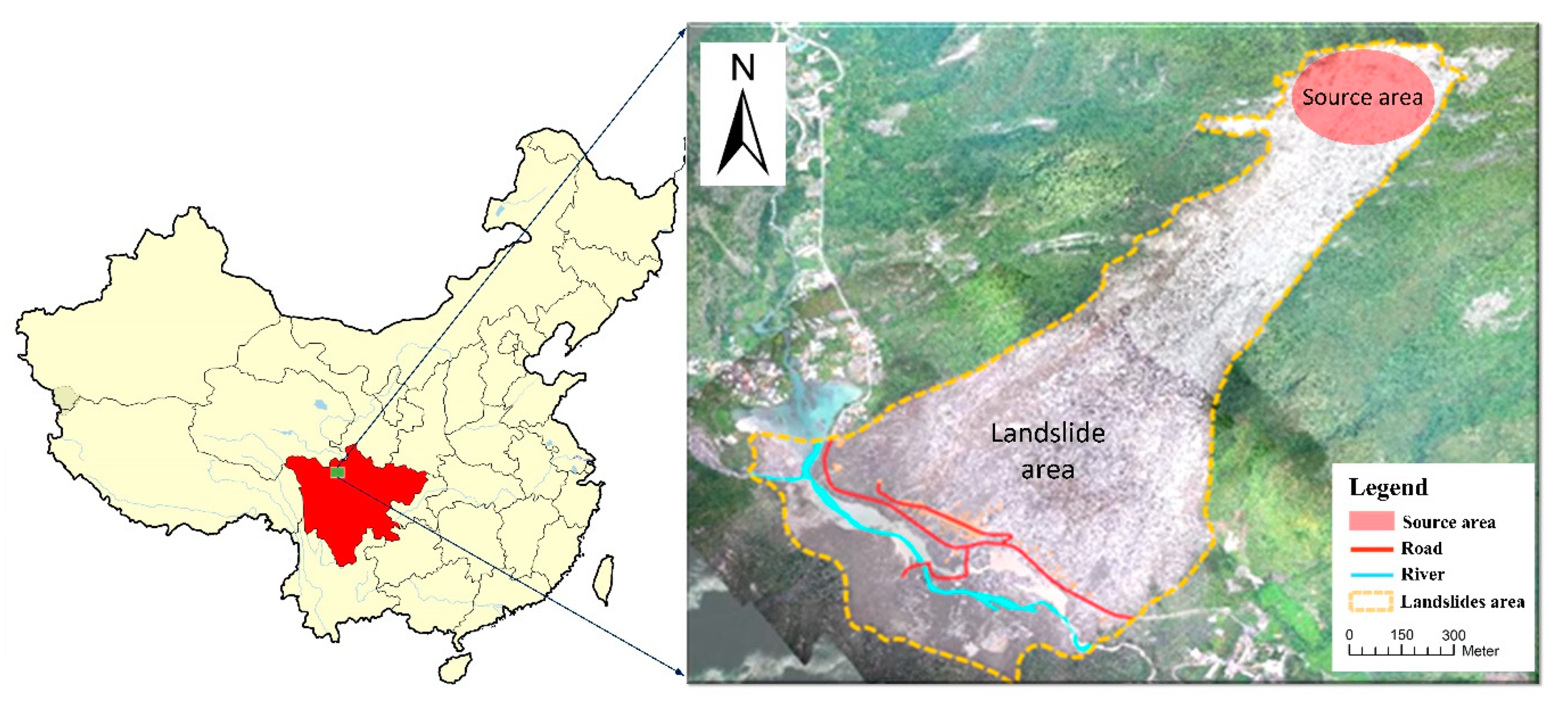
3.1. Test Data Description
3.2. Advantageous Information Selection Process
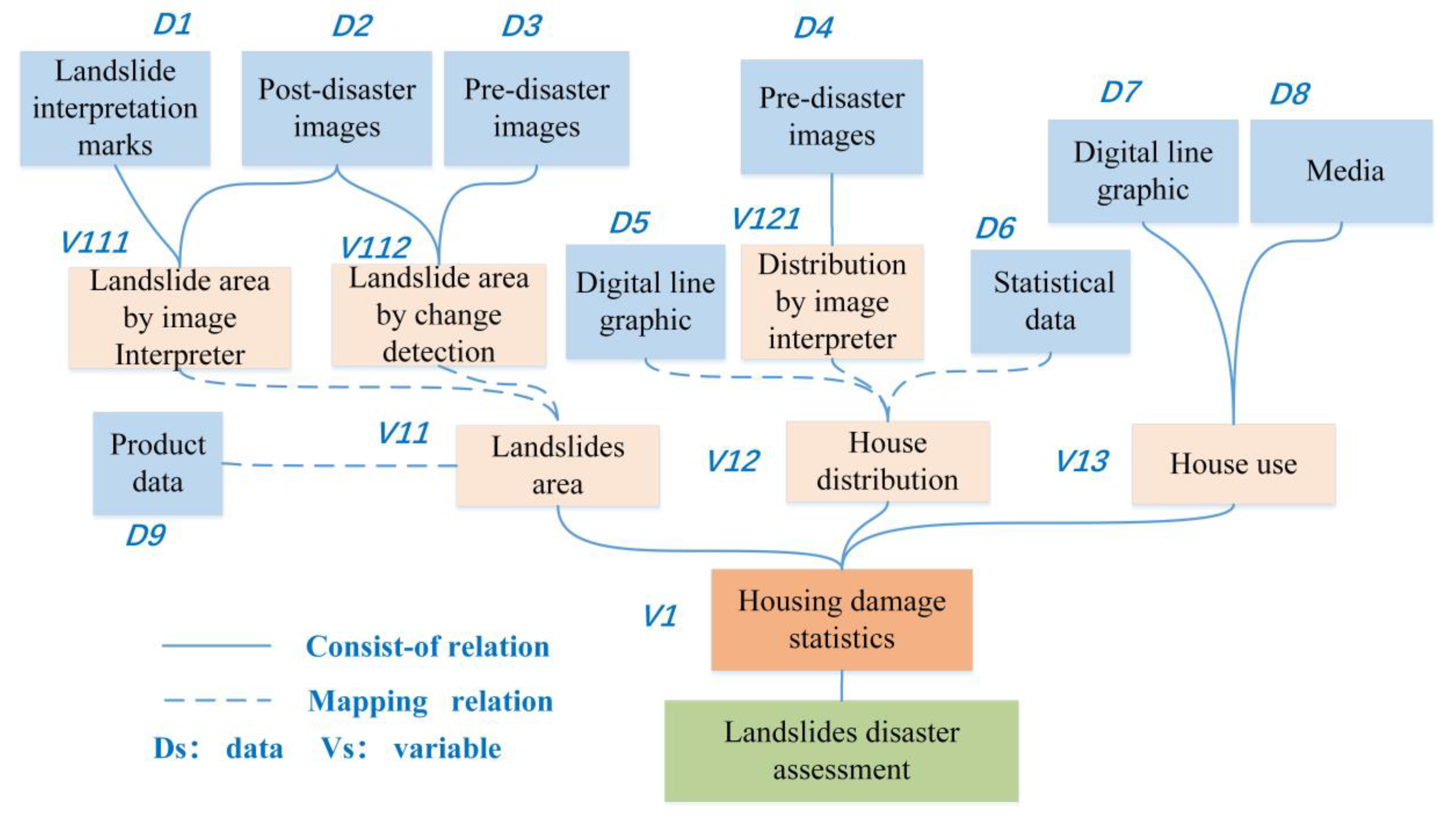
3.2.1. Task and Data Preparation
3.2.2. Data Filtering
3.2.3. Task-Level Relationship Construction
3.2.4. Selection and Optimization of Datasets
3.3. Selection Results
4. Result Analysis and Discussion
5. Conclusions and Future Studies
Author Contributions
Funding
Conflicts of Interest
References
- Kryvasheyeu, Y.; Chen, H.; Obradovich, N.; Moro, E.; Van Hentenryck, P.; Fowler, J.; Cebrian, M. Rapid assessment of disaster damage using social media activity. Sci. Adv. 2016, 2, e1500779. [Google Scholar] [CrossRef] [PubMed]
- Qiu, L.Y.; Zhu, Q.; Gu, J.Y.; Du, Z.Q. A task-driven disaster data link approach. Int. Arch. Photogram. Remote Sens. Spat. Inf. Sci. 2015, 40, 179–186. [Google Scholar] [CrossRef]
- Velev, D.; Zlateva, P. Current state of enterprise 2.0 knowledge management. Int. J. Trade Econ. Financ. 2012, 39, 245–250. [Google Scholar] [CrossRef]
- Tsai, F.; Hwang, J.H.; Chen, L.C.; Lin, T.H. Post-disaster assessment of landslides in southern Taiwan after 2009 Typhoon Morakot using remote sensing and spatial analysis. Nat. Hazards Earth Syst. Sci. 2010, 10, 2179–2190. [Google Scholar] [CrossRef]
- Hayashi, H.; Asahara, A.; Sugaya, N.; Ogawa, Y.; Tomita, H. Spatio-temporal similarity search method for disaster estimation. In Proceedings of the 2015 IEEE International Conference on Big Data (Big Data), Santa Clara, CA, USA, 29 October–1 November 2015; Hayashi, H., Asahara, A., Sugaya, N., Ogawa, Y., Tomita, H., Eds.; IEEE: Washington, DC, USA, 2014. [Google Scholar]
- Alizadeh, M.; Ngah, I.; Hashim, M.; Pradhan, B.; Pour, B.A. A Hybrid Analytic Network Process and Artificial Neural Network (ANP-ANN) model for urban Earthquake vulnerability assessment. Remote Sens. 2018, 10, 975. [Google Scholar] [CrossRef]
- Alizadeh, M.; Alizadeh, E.; Kotenaee, S.A.; Shahabi, H.; Pour, B.A.; Panahi, M.; Bin Ahmad, B.; Saro, L. Social vulnerability assessment using artificial neural network (ANN) model for earthquake hazard in Tabriz city, Iran. Sustainability 2018, 10, 3376. [Google Scholar] [CrossRef]
- Alizadeh, M.; Hashim, M.; Alizadeh, E.; Shahabi, H.; Karami, M.R.; Pour, A.B.; Paradhan, B.; Zabihi, H. Multi-criteria decision making (MCDM) model for seismic vulnerability assessment (SVA) of urban residential buildings. Isprs Int. J. Geo-Inf. 2018, 7, 444. [Google Scholar] [CrossRef]
- Guillera-Arroita, G.; Lahoz-Monfort, J.J.; Elith, J.; Gordon, A.; Kujala, H.; Lentini, P.E.; McCarthy, M.A.; Tingley, R.; Wintle, B.A. Is my species distribution model fit for purpose? Matching data and models to applications. Glob. Ecol. Biogeogr. 2015, 24, 276–292. [Google Scholar] [CrossRef]
- Tarboton, D.G.; Idaszak, R.; Horsburgh, J.S.; Heard, J.; Ames, D.; Goodall, J.L.; Band, L.; Merwade, V.; Couch, A.; Arrigo, J.; et al. HydroShare: Advancing collaboration through hydrologic data and model sharing. In Proceedings of the 7th International Congress on Environmental Modelling and Software: Bold Visions for Environmental Modeling, iEMSs 2014, San Diego, CA, USA, 15–19 June 2014; Tarboton, D.G., Idaszak, R., Horsburgh, J.S., Heard, J., Ames, D., Goodall, J.L., Band, L., Merwade, V., Couch, A., Arrigo, J., et al., Eds.; International Environmental Modelling and Software Society: San Diego, CA, USA, 2014. [Google Scholar]
- Zhu, Y.; Zhu, A.X.; Feng, M.; Song, J.; Zhao, H.; Yang, J.; Zhang, Q.; Sun, K.; Zhang, J.; Yao, L. A similarity-based automatic data recommendation approach for geographic models. Int. J. Geogr. Inf. Sci. 2017, 31, 1403–1424. [Google Scholar] [CrossRef]
- Goodchild, M.F.; Glennon, J.A. Crowdsourcing geographic information for disaster response: A research frontier. Int. J. Digit. Earth. 2010, 3, 231–241. [Google Scholar] [CrossRef]
- Pu, C.; Kitsuregawa, M. Big Data and Disaster Management: A Report from the JST/NSF Joint Workshop; Georgia Institute of Technology, CERCS: Atlanta, GA, USA, 2013. [Google Scholar]
- Guo, H.; Wang, L.; Chen, F.; Liang, D. Scientific big data and digital earth. Chin. Sci. Bull. 2014, 59, 5066–5073. [Google Scholar] [CrossRef]
- Hashim, M.; Misbari, S.; Pour, B.A. Landslide mapping and assessment by integrating Landsat-8, PALSAR-2 and GIS techniques: A case study from Kelantan state, peninsular Malysia. J. Indian Soc. Remote Sens. 2018, 46, 233–248. [Google Scholar] [CrossRef]
- Pour, B.A.; Hashim, M. Application of Landsat-8 and ALOS-2 data for structural and landslide hazard mapping in Kelantan, Malaysia. Nat. Hazards Earth Syst. Sci. 2018, 17, 1285–1303. [Google Scholar] [CrossRef]
- Hu, Y. Geospatial semantics. In Comprehensive Geographic Information Systems, also Included in Elsevier’s Reference Module in Earth Systems and Environmental Sciences; Huang, B., Cova, T.J., Tsou, M., Eds.; Elsevier: Oxford, UK, 2017; pp. 80–94. [Google Scholar]
- Li, J.; Zlatanova, S.; Fabbri, A.G. Geomatics Solutions for Disaster Management; Springer: New York, NY, USA, 2007. [Google Scholar]
- Fernández, M.; Cantador, I.; López, V.; Vallet, D.; Castells, P.; Motta, E. Semantically enhanced information retrieval: An ontology-based approach. J. Web Semant. 2011, 9, 434–452. [Google Scholar] [CrossRef]
- Hristidis, V.; Chen, S.-C.; Li, T.; Luis, S.; Deng, Y. Survey of data management and analysis in disaster situations. J. Syst. Softw. 2010, 83, 1701–1714. [Google Scholar] [CrossRef]
- Wiegand, N.; García, C. A task-based ontology approach to automate geospatial data retrieval. Trans. GIS 2007, 11, 355–376. [Google Scholar] [CrossRef]
- Wu, Y.; Zhong, Z.; Xiong, W.; Jing, N. Geo-Link: Correlations of heterogeneous geo-spatial entities. Arab. J. Sci. Eng. 2014, 39, 8811–8824. [Google Scholar] [CrossRef]
- Fan, Z.; Zlatanova, S. Exploring ontologies for semantic interoperability of data in emergency response. Appl. Geomat. 2011, 3, 109–122. [Google Scholar] [CrossRef]
- Qiu, L.; Du, Z.; Zhu, Q.; Fan, Y. An integrated flood management system based on linking environmental models and disaster-related data. Environ. Model. Softw. 2017, 91, 111–126. [Google Scholar] [CrossRef]
- Schulz, A.; Döweling, S.; Probst, F. Integrating process modeling and linked open data to improve decision making in disaster management. In International Reports on Socio-Informatics (IRSI), Proceedings of the CSCW 2012 Workshop on Collaboration and Crisis Informatics, Seattle, WA, USA, 11–15 February 2012; Pipek, V., Landgren, J., Palen, L., Eds.; International Institute for Socio-Informatics: Bonn, Germany, 2012. [Google Scholar]
- Silva, T.; Wuwongse, V.; Sharma, H.N. Disaster mitigation and preparedness using linked open data. J. Ambient Intell. Hum. Comput. 2012, 4, 591–602. [Google Scholar] [CrossRef]
- Janowicz, K.; Raubal, M.; Kuhn, W. The semantics of similarity in geographic information retrieval. J. Spat. Inf. Sci. 2011, 2, 29–57. [Google Scholar] [CrossRef]
- Sun, S.; Wang, L.; Ranjan, R.; Wu, A. Semantic analysis and retrieval of spatial data based on the uncertain ontology model in digital earth. Int. J. Digit. Earth 2015, 8, 3–16. [Google Scholar] [CrossRef]
- Zhu, Y.; Zhu, A.X.; Song, J.; Yang, J.; Feng, M.; Sun, K.; Zhang, J.; Hou, Z.; Zhao, H. Multidimensional and quantitative interlinking approach for linked geospatial data. Int. J. Digit. Earth 2017, 10, 923–943. [Google Scholar] [CrossRef]
- Guyon, I.; Elisseeff, A.; Kaelbling, L.P. An introduction to variable and feature selection. J. Mach. Learn. Res. 2003, 3, 1157–1182. [Google Scholar] [CrossRef]
- Tang, J.; Alelyani, S.; Liu, H. Feature selection for classification: A review. In Data Classification: Algorithms and Applications; Aggarwal, C., Ed.; CRC Press: Boca Raton, FL, USA, 2014; pp. 37–64. [Google Scholar]
- Bolón-Canedo, V.; Sánchez-Maroño, N.; Alonso-Betanzos, A. Recent advances and emerging challenges of feature selection in the context of big data. Knowl. Based Syst. 2015, 86, 33–45. [Google Scholar] [CrossRef]
- Li, J.; Cheng, K.; Wang, S.; Morstatter, F.; Trevino, R.P.; Tang, J.; Liu, H. Feature selection. ACM Comput. Surv. 2016, 50, 1–45. [Google Scholar] [CrossRef]
- Peng, H.; Long, F.; Ding, C. Feature selection based on mutual information: Criteria of max-dependency, max-relevance, and min-redundancy. IEEE Trans. Pattern Anal. Mach. Intell. 2005, 27, 1226–1238. [Google Scholar] [CrossRef] [PubMed]
- Ramírez-Gallego, S.; Lastra, I.; Martínez-Rego, D.; Bolón-Canedo, V.; Benítez, J.M.; Herrera, F.; Alonso-Betanzos, A. Fast-mRMR: Fast minimum redundancy maximum relevance algorithm for high-dimensional big data. Int. J. Intell. Syst. 2016, 32, 134–152. [Google Scholar] [CrossRef]
- Jovic, A.; Brkic, K.; Bogunovic, N. A review of feature selection methods with applications. In Proceedings of the 2015 38th International Convention on Information and Communication Technology, Electronics and Microelectronics (MIPRO), Opatija, Croatia, 25–29 May 2015; Jovic, A., Brkic, K., Bogunovic, N., Eds.; IEEE: Opatija, Croatia, 2015. [Google Scholar]
- Yang, Q.; Shao, J.; Scholz, M.; Plant, C. Feature selection methods for characterizing and classifying adaptive sustainable flood retention basins. Water Res. 2011, 45, 993–1004. [Google Scholar] [CrossRef]
- Chen, Z.; Wu, C.; Zhang, Y.; Huang, Z.; Ran, B.; Zhong, M.; Lyu, N. Feature selection with redundancy-complementariness dispersion. Knowl. Based Syst. 2015, 89, 203–217. [Google Scholar] [CrossRef]
- Zeng, Z.; Zhang, H.; Zhang, R.; Yin, C. A novel feature selection method considering feature interaction. Pattern Recognit. 2015, 48, 2656–2666. [Google Scholar] [CrossRef]
- Bratasanu, D.; Nedelcu, I.; Datcu, M. Bridging the semantic gap for satellite image annotation and automatic mapping applications. IEEE J. Sel. Top. Appl. Earth Obs. Remote Sens. 2011, 4, 193–204. [Google Scholar] [CrossRef]
- Liu, X.; He, J.; Yao, Y.; Zhang, J.; Liang, H.; Wang, H.; Hong, Y. Classifying urban land use by integrating remote sensing and social media data. Int. J. Geogr. Inf. Sci. 2017, 31, 1675–1696. [Google Scholar] [CrossRef]
- Atkinson, P.M.; Aplin, P. Spatial variation in land cover and choice of spatial resolution for remote sensing. Int. J. Remote Sens. 2004, 25, 3687–3702. [Google Scholar] [CrossRef]
- Li, M.; Zhu, X.; Guo, W.; Yue, P.; Fan, Y. A case-based reasoning approach for task-driven remote sensing image discovery under spatial–temporal constraints. IEEE J. Sel. Top. Appl. Earth Obs. Remote Sens. 2016, 9, 454–466. [Google Scholar] [CrossRef]
- de Albuquerque, J.P.; Herfort, B.; Brenning, A.; Zipf, A. A geographic approach for combining social media and authoritative data towards identifying useful information for disaster management. Int. J. Geogr. Inf. Sci. 2015, 29, 667–689. [Google Scholar] [CrossRef]
- Rosser, J.F.; Leibovici, D.G.; Jackson, M.J. Rapid flood inundation mapping using social media, remote sensing and topographic data. Nat. Hazards 2017, 87, 103–120. [Google Scholar] [CrossRef]
- Jia, X.; Tinghua, A.; Peng, Z.; Wang, G. The LOD representation and proximity measurement of semantic about geographic information. Geomat. Inf. Sci. Wuhan Univ. 2016, 41, 1299–1306. [Google Scholar]
- Resnik, P. Semantic similarity in a taxonomy: An information-based measure and its application to problems of ambiguity in natural language. J. Artif. Intell. Res. 1999, 11, 95–130. [Google Scholar] [CrossRef]
- Rodríguez, M.A.; Egenhofer, M.J. Comparing geospatial entity classes: An asymmetric and context-dependent similarity measure. Int. J. Geogr. Inf. Sci. 2004, 18, 229–256. [Google Scholar] [CrossRef]
- Kim, J.; Vasardani, M.; Winter, S. Similarity matching for integrating spatial information extracted from place descriptions. Int. J. Geogr. Inf. Sci. 2017, 31, 56–80. [Google Scholar] [CrossRef]
- Sun, Y.; Han, J. Mining heterogeneous information networks: Principles and methodologies. Synth. Lect. Data Min. Knowl. Discov. 2012, 3, 1–159. [Google Scholar] [CrossRef]
- Shi, C.; Li, Y.; Zhang, J.; Sun, Y.; Yu, P.S. A survey of heterogeneous information network analysis. IEEE Trans. Knowl. Data Eng. 2015, 29, 17–37. [Google Scholar] [CrossRef]
- Sun, Y.; Han, J.; Yan, X.; Yu, P.S.; Wu, T. Pathsim: Meta path-based top-k similarity search in heterogeneous information networks. Proc. Vldb Endow. 2011, 4, 992–1003. [Google Scholar]
- Fan, X.; Xu, Q.; Scaringi, G.; Dai, L.; Li, W.; Dong, X.; Zhu, X.; Pei, X.; Dai, K.; Havenith, H.B. Failure mechanism and kinematics of the deadly June 24th 2017 Xinmo landslide, Maoxian, Sichuan, China. Landslides 2017, 14, 2129–2146. [Google Scholar] [CrossRef]
- Chen, K.T.; Wu, J.H. Simulating the failure process of the Xinmo landslide using discontinuous deformation analysis. Eng. Geol. 2018, 239, 269–281. [Google Scholar] [CrossRef]


| No. | Data Title/Description | Spatiotemporal Similarity | Scale Similarity | Attribute Similarity | Corresponding Variables | Relevance |
|---|---|---|---|---|---|---|
| 1 | 2017.6.25 Diexi Town, Mao County landslide interpretation results. 1:500 | 1.000 | 1 | 1.000 | D9 | 1.0000 |
| 2 | 2017.6.25 Diexi Town, Mao County landslide UAV optical images 0.1 m | 1.000 | 1 | 1.000 | D2 | 1.0000 |
| 3 | 2017.6.24 Gaofen-3 satellite radar image 1 m | 1.000 | 0.875 | 0.500 | null | 0.7917 |
| 4 | 2017.4.8 Gaofen-2 satellite optical image 1 m | 0.590 | 0.875 | 0.750 | D3,D4 | 0.7383 |
| 5 | 2016.12 Gaofen-2 satellite optical image 1 m | 0.430 | 0.875 | 0.750 | D4 | 0.6850 |
| 6 | Multimedia datasets | 1.000 | 0.875 | 0.000 | D8 | 0.6250 |
| 7 | 2017.6.24 Diexi Town, Mao County landslide UAV optical images 0.1 m | 0.400 | 1 | 1.000 | D3,D4 | 0.6000 |
| 8 | 2017.6.24 Diexi Town, Mao County landslide interpretation results. 1:500 | 0.400 | 1 | 1.000 | D9 | 0.6000 |
| 9 | 2017.5.31 ZY-3 satellite optical image 2.1 m | 0.729 | 0.125 | 0.750 | D3,D4 | 0.5347 |
| 10 | 2017.5.16 ZY-3 satellite optical image 2.1 m | 0.656 | 0.125 | 0.750 | D3,D4 | 0.5103 |
| 11 | 2014.11.1 Diexi Town, Mao County DLG 1:10000 | 0.254 | 0.125 | 0.667 | D5,D7 | 0.3486 |
| 12 | 2015.1 Diexi Town, Mao County DLG 1:50000 | 0.254 | 0.125 | 0.667 | D5,D7 | 0.3486 |
| 13 | 2014.12 Diexi Town, Mao County DLG 1:50000 | 0.206 | 0.125 | 0.667 | D5,D7 | 0.3326 |
| 14 | 2013 Diexi Town, Mao County DLG 1:50000 | 0.185 | 0.125 | 0.667 | D5,D7 | 0.3256 |
| 15 | 2011 Diexi Town, Mao County DLG 1:50000 | 0.119 | 0.125 | 0.667 | D5,D7 | 0.3036 |
| 16 | 2015.12 Mao County DLG | 0 | 0.875 | 0.333 | D5,D7 | 0.1111 |
| 17 | 2014.8 Mao County DLG | 0 | 1 | 0.333 | D5,D7 | 0.1111 |
| Results: selected items (Nos. 1, 4, 5, 6, and 11), irrelevant items (Nos. 3, 16, and 17), and redundant items (others). | ||||||
| Query Method | Result Number | Relevant Number | Redundant Number | Irrelevant Number | Recall | Precision | |
|---|---|---|---|---|---|---|---|
| Relevance-based | 0.7 | 4 | 3 | 1 | 1 | 40% | 75% |
| 0.5 | 10 | 9 | 5 | 1 | 80% | 40% | |
| 0.3 | 15 | 14 | 8 | 1 | 100% | 33% | |
| Keyword-based | 15 | 12 | 9 | 3 | 100% | 33% | |
| Semantics-constrained (proposed method) | 5 | 5 | 0 | 0 | 100% | 100% | |
© 2019 by the authors. Licensee MDPI, Basel, Switzerland. This article is an open access article distributed under the terms and conditions of the Creative Commons Attribution (CC BY) license (http://creativecommons.org/licenses/by/4.0/).
Share and Cite
Zhu, Q.; Zhang, J.; Ding, Y.; Liu, M.; Li, Y.; Feng, B.; Miao, S.; Yang, W.; He, H.; Zhu, J. Semantics-Constrained Advantageous Information Selection of Multimodal Spatiotemporal Data for Landslide Disaster Assessment. ISPRS Int. J. Geo-Inf. 2019, 8, 68. https://doi.org/10.3390/ijgi8020068
Zhu Q, Zhang J, Ding Y, Liu M, Li Y, Feng B, Miao S, Yang W, He H, Zhu J. Semantics-Constrained Advantageous Information Selection of Multimodal Spatiotemporal Data for Landslide Disaster Assessment. ISPRS International Journal of Geo-Information. 2019; 8(2):68. https://doi.org/10.3390/ijgi8020068
Chicago/Turabian StyleZhu, Qing, Junxiao Zhang, Yulin Ding, Mingwei Liu, Yun Li, Bin Feng, Shuangxi Miao, Weijun Yang, Huagui He, and Jun Zhu. 2019. "Semantics-Constrained Advantageous Information Selection of Multimodal Spatiotemporal Data for Landslide Disaster Assessment" ISPRS International Journal of Geo-Information 8, no. 2: 68. https://doi.org/10.3390/ijgi8020068
APA StyleZhu, Q., Zhang, J., Ding, Y., Liu, M., Li, Y., Feng, B., Miao, S., Yang, W., He, H., & Zhu, J. (2019). Semantics-Constrained Advantageous Information Selection of Multimodal Spatiotemporal Data for Landslide Disaster Assessment. ISPRS International Journal of Geo-Information, 8(2), 68. https://doi.org/10.3390/ijgi8020068