Article

Evaluating a Fit-For-Purpose Integrated Service-Oriented Land and Climate Change Information System for Mountain Community Adaptation

1
Faculty of Geo-Information Science and Earth Observation (ITC), University of Twente, P.O. Box 217, 7500 AE Enschede, The Netherlands
2
Swinburne Business School, Swinburne University of Technology, P.O. Box 218, Hawthorn, VIC 3122, Australia
*
Author to whom correspondence should be addressed.
ISPRS Int. J. Geo-Inf. 2018, 7(9), 343; https://doi.org/10.3390/ijgi7090343
Submission received: 24 June 2018 / Revised: 6 August 2018 / Accepted: 20 August 2018 / Published: 23 August 2018

Abstract

:
Climate change challenges mountain communities to prepare themselves via Community-Based Adaptation (CBA) plans that reduce vulnerability. This paper outlines the evaluation of a developed web-based information system to support CBA, referred to as a Mountain Community Adaptive System (MCAS). The web-based user interface visualizes collated data from data providers, integrating it with near real-time climate and weather datasets. The interface provides more up-to-date information than was previously available on the environment, particularly on land and climate. MCAS, a cloud-based Land Information System (LIS), was developed using an Agile-inspired approach offering system creation based on bare minimum system requirements and iterative development. The system was tested against Fit-For-Purpose Land Administration (FFP LA) criteria to assess the effectiveness in a case from Nepal. The results illustrate that an MCAS-style system can provide useful information such as land use status, adaptation options, near real-time rainfall and temperature details, amongst others, to enable services that can enhance CBA activities. The information can facilitate improved CBA planning and implementation at the mountain community level. Despite the mentioned benefits of MCAS, ensuring system access was identified as a key limitation: smartphones and mobile technologies still remain prohibitively expensive for members of mountain communities, and underlying information communication technology (ICT) infrastructures remain under-developed in the assessed mountain communities. The results of the evaluation further suggest that the land-related aspects of climate change should be added to CBA initiatives. Similarly, existing LIS could have functionalities extended to include climate-related variables that impact on land use, tenure, and development.

1. Introduction

Community-Based Adaptations (CBAs) are policy driven interventions, focused on agricultural investment [1], via community-based activities [2]. CBA faces several challenges being often project-based and small-scale in nature [3], power relations at the community level can impede success [4], and there can be a general “lack of support from the government” [5]. Moreover, culture can create social barriers, and the role of institutions can impede information availability [6], and the supportive information that is required to assist the CBA is often incomplete, unavailable, or out-of-date [7,8].
The lack of supportive information to promote CBA is the focus of this study. Effective CBA demands that communities are equipped with the relevant information about land and climate. This enables engagement and assists decision-making at the local level to realize the true benefits of CBA. Decision-making might involve selecting between the range of adaptation options including crop diversity plans, soil conservation, and tree planting, among others [9]. Currently, communities are not able to maximize a full understanding of the available resources, risks, and vulnerabilities at a high level of detail. If community stakeholders are uncertain about the goals and objectives of CBA, it can cause competition or opposition [10].
In response, the purpose of this study is to evaluate whether a developed web-based Land Information System (LIS) tool can support and enhance CBA activities. The planned tool could integrate a variety of land information, including administrative boundaries, roads, land use, cadastre, topography, hydro lines as well as climate change data—including rainfall and temperature—for rural mountain communities. To present the evaluation, first the background, the materials and the methods for development and evaluation of a web-based LIS tool are explained in Section 2 and Section 3. Evaluation of the system, against adapted Fit-For-Purpose Land Administration (FFP LA) criteria, is then presented in Section 4. The purpose of the evaluation is to identify whether the designed system (MCAS) supports climate adaptation services for CBA. The critical findings based on the evaluation are discussed in Section 5. The conclusion is presented in Section 6.

2. Background

Mountainous zones have specific contextual challenges including high altitude, dense fog, heavy rain and snow, potential avalanches and falling rocks amongst others: technology applications may require adaptation or extensions beyond those applied in other contexts. Often, power lines and cables hardly reach such communities, leading to lack of electricity, internet, and mobile network coverage. Communities are scattered in small populations and may be skipped over in programs aimed at enabling technology update and dissemination. In these areas installation, repair, and maintenance of any old and new information communication technology (ICT) infrastructure is more challenging than in other contexts. It is more complicated and time-consuming to transfer the required personnel and materials to such places as supportive infrastructure, for example, roads and transport infrastructure, are often weaker or damaged. Whilst geospatial data including satellite images, surveying and cartography facilitate information provision about mountainous areas, issues of excessive terrain relief [11], atmospheric errors, shadow effects in satellite images [12,13], human resource limitations (in surveying), also lead to incomplete spatial information coverage of mountainous areas [14].
Despite the challenges in mountainous areas, the potential for ICT to support management of mountainous areas cannot be denied: ICT can play a substantial role in strengthening community adaptive capacity [15]. Communication and information infrastructures are increasingly providing better services to users, even in remote locations. ICT tools such as mobile and web-based information interfaces can present a wide variety of information about the current status of land and climate—but, also historical and predicted scenarios. Such information can facilitate the engagement of rural mountain communities in CBA to better respond to relevant needs. ICT applications such as integrated land and climate change data, known as LIS, can enable mountain communities to become principal actors and decision-makers in CBA.
Developments are occurring rapidly in this space. New information channels including online groups and digital forums are developed to improve the exchange of knowledge related to community adaptation. For instance, Shack/Slum Dwellers International (SDI) provides information on community risk reduction in 33 countries in Africa, Asia, and Latin America [16]. There exists mountain-based IS tools that are dedicated to providing alarm and warning services in high mountains: GeoAvalanche crowdsources snow avalanche information to support tourist safety and resource management in the European Alps. It shares avalanche data and maps of risk zones via a website, accessible via smartphones. Users subscribe to geo-portals communicate 2-way on alerts about avalanche incidents and snow conditions. It creates a regional interoperable network to contribute to avalanche bulletin maps [17]. Geopraevent operates alarm and monitoring systems for natural hazards and displays the results online to experts, local authorities, and people in different mountainous in China and the European Alps, amongst others. Different sensors, including people radar, a rock fall radar, webcams, and infrared cameras, plus geophones and weather stations, are combined to supply data within the data portal. Information about glacial lakes, permafrost, and flood waves, among others, are available on all devices [18].
Despite these developments, further investigation reveals that an integrated land and climate change IS has not been developed for CBA initiatives, particularly in developing contexts. Table 1 presents some web-based and mobile applications that provide different services to support citizens directly. Only Fog Watch application can be considered a climate change relevant mountain IS application: it provides information about fog density in ‘Indo-Gangetic Plain and Brahmaputra Basin’ [19]. The other apps (marked * in Table 1) provide information in all European countries, but, not necessarily on land and climate change. Most of the applications are specifically for experts or specialists working within scientific fields or sectors, such as MySeason, an app not intended for local participants. It is also worth mentioning the listed applications do not support the crowdsourcing concept that enables broader and richer information to be included in the system.
In this study, a web-based information system referred to as Mountain Community Adaptive System (MCAS) is developed to promote CBA. MCAS is intended to provide near-real-time information on temperature and rainfall, along with other localized data, provided by local communities via crowdsourcing, about land use and land holdings, including imagery that could act as an enabler and enhancer of existing CBA initiatives. Importantly, it is necessary to verify whether MCAS is capable of providing information services that support CBA. On this, growing from part 6 section 23 of the Voluntary Guidelines on the Responsible Governance of Tenure of land, fisheries and forests in the Context of national food security (VGGTs) [20], where participation and consultation with communities and individuals are recommended for land tenure security programs, the World Bank and the International Federation of Surveyors (FIG) developed the FFP LA framework, including a set of design principles, to simplify providing tenure security, control of land use and natural resources for all, particularly in less developed countries. The FFP approach seeks to bypass establishment of costly, time-consuming and sophisticated LA systems that demand professional personnel to work. The FFP LA approach ‘allows a system to be incrementally improved over time.’ [21]. This means FFP LA is a flexible and affordable approach focusing on the quality of the services to satisfy users’ needs.
Analysis of the FFP approach shows that LIS underpins global issues including climate change [22]. International organizations such as FAO and UN-GGIM support LA projects that are designed closely to FFP principals since it identifies the purpose/s of a system and decides on what to include in the system to improve [23]. The FFP LA frameworks—spatial, legal, and institutional—need to interact to support delivery of fundamental data for geospatial information management, protect the tenure security of local people from risks of climate change and natural disasters and manage lands in rapid urbanization and land conflicts [24]. Mitchell et al. [21] also indicate that the FFP LA concepts and tools can support the enhancement of adaptation to climate change. In this vein, the FFP LA frameworks appear to be suitable for evaluating MCAS: MCAS seeks a flexible and low-cost approach for creating and sharing the land and climate data amongst community stakeholders, one that enhances CBA-related decision making. The objectives of FFP LA and MCAS are closely aligned.

3. Materials and Methods

In this section the criteria for case selection and data collection processes are discussed first. The MCAS development process is then explained, as are the system architecture and evaluation criteria based on FFP LA, and subsequently the test plan.

3.1. Study Area and Its Context

Within Nepal, one of the most climate affected countries [25] Dolakha district is selected since it is ranked very low on combined/multiple adaptation capability indices, which include socio-economic, technologic (irrigation system), and infrastructural (road and communication) adaptation capability [26]. Figure 1 presents Dolakha district, Nepal. Dolakha faces many challenges regarding CBA. In response, this study proposed the establishment of an LIS to support evidence-based design and implementation of CBA—based on relevant and highly granular spatial data and services [27]. The data requirements for the intended LIS were collected in Dolakha district.
Land and climate data were necessary to populate the system. CBA data were derived from the analysis of in-depth interviews with the district key experts, an NGO, Focus Group Interview (FGI) of two communities in two Village Development Committees (VDCs, the lowest administrative unit of Nepal), individual household surveys, and the personal observations of the first author of this paper during research. Specifics on the data collection, analysis, and requirement synthesis activities are available in [27]. The process included coverage of fieldwork activities, FGI and household surveys, in-depth interviews with the district key experts, data analysis, and synthesis. Individual household surveys were conducted in three VDCs including Susma Chhemawati (n = 11), Bocha (n = 8) and Charikot (n = 10), coupled with FGIs with the local communities of Bocha (n = 21) and Charikot (n = 19), in-depth interviews of district offices (n = 5), an NGO, and participants at the national level (n = 5). Spatial and non-spatial data collected from the International Centre for Integrated Mountain Development (ICIMOD), the District Forest Office (DFO), the District Survey Office (DSO) and the Department of Hydrology and Meteorology (DHM) populated the LIS. These organizations are selected because ICIMOD is an active knowledge sharing center that assists mountain people to understand climate change and its impacts. DFO and DSO are involved with forest and agriculture land-based activities amongst others. DHM provides temperature and rainfall data.

3.2. Agile-Inspired Development Process

The development of any IS requires the utilization of a development methodology. Agile development is increasingly identified as a suitable method that receives interest in the process of IS development. Every iteration of Agile development includes planning, analysis, design, and testing; allowing an IS to change and develop gradually over time [28]. The literature shows the nature and use of Agile in IS development occurs in diverse fields and has theoretical linkages to socio-technical approaches [29], teamwork models [30], complex adaptive systems [31], and knowledge management [32]. Since Agile development simplifies the development process [28], an Agile-inspired approach was applied in this study for the prototype development of MCAS.
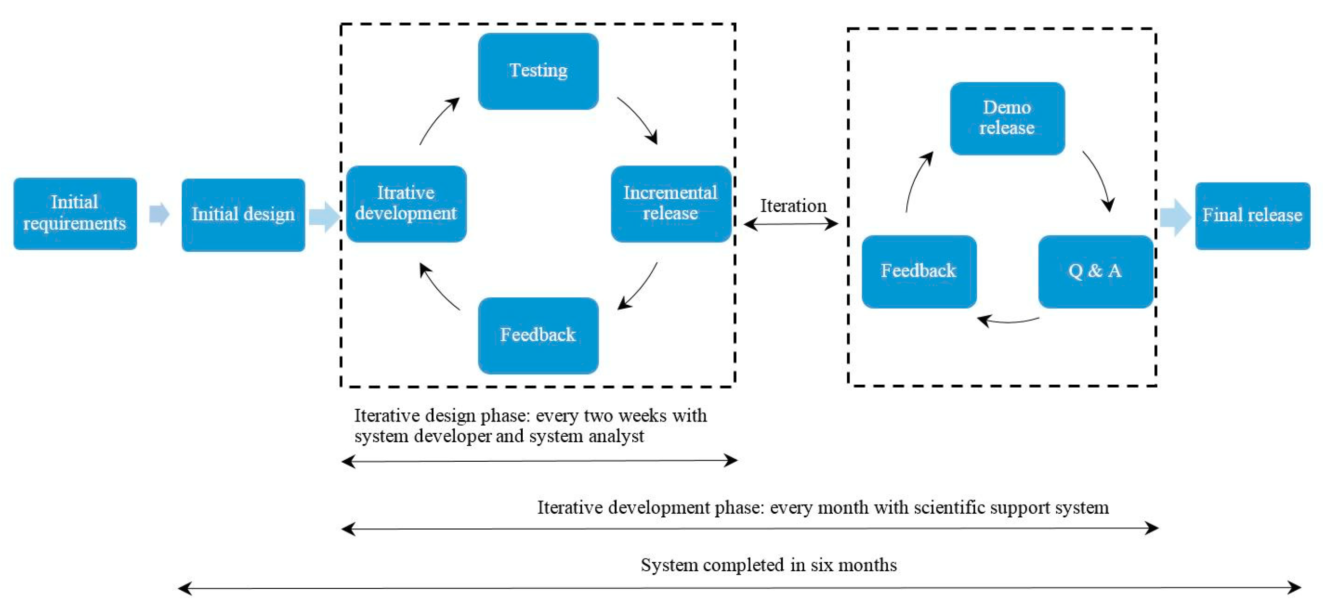
In the Agile Manifesto, the 7th principal is “Working software is the primary measure of progress” [33]. In the Agile method, the focus is not on long-term planning or documentation nor the developer or client contract [32]. The system starts working with the minimum system requirements. The developers and client/s take feedback from each other at pre-defined time intervals to sustain client/s needs with the system [34]. It is an interactive and iterative model that has been used to develop and refine MCAS. “Short time development, implementation and testing” during six months (May–October 2016) were defined because of the research time constraints. In May 2016, a core team of three consisting of a system developer (technical IS), a systems analyst (technical IS and land and climate change researcher), and a scientific project adviser (technical IS, land informatics and project advisor) started the MCAS development. The team was kept small: it was easy to communicate, and only the required people were included. The system developer was a Nepalese national with connections to the mountain communities. In addition, the system analyst spent over one month embedded with specific mountain communities in order to be sensitized with conditions, livelihoods, and environments. Although not ideal (This limitation and potential responses is covered in more depth under ‘5. Discussion’), both the system developer and the system analyst acted as the users of MCAS at the time of its prototype development and implementation to put the work well into the desired context.
Face-to-face communication was performed between the system developer and the system analyst every two weeks and with the team every month for six months to complete the project. This iterative communication was focused on the prototype development of MCAS, its implementation, and testing, providing technical and scientific feedback from the team members to improve MCAS. The prototype development was separated from the core users, meaning it diverged from a more purist Agile approach. An Agile-inspired approach emphasizes teamwork and user satisfaction [35]. Although incorporating users is an efficient way to capture user requirements in an Agile approach, too little contribution from an end-user is often reported as a weakness in system development [36]. Due to the limited capacity of the system analyst including time and cost, and lack of direct and indirect contact with the mountain communities, which is something that needs to be noted for any future scaling or implementation work, the team simulated receiving input from the communities: the system developer and the system analyst tried to act as much as possible as the users, based on the earlier findings regarding the requirements (see Section 3.1). Every two weeks, the testing of MCAS provided feedback from the developer and the analyst to consider required changes in MCAS—requirements including technology, types of services and system performance were considered. To grasp the needs concerning land and climate change services, the system requirements came from Section 3.1 and the system developer. Figure 2 presents the Agile-inspired approach of the MCAS prototype development and how all the tasks fit together.

3.3. Information System Architecture

MCAS needed both hardware and software for data processing. The hardware for data repository and visualization needed to be able to remain consistent with both pull and push mechanisms in the system. In addition, the land and climate change data and web-services in the MCAS included raster and vector data, images, and geo-location points. The system was also considered to need to incorporate desktop PC, laptop, and smartphone compatibility. Open-source software including Quantum GIS (QGIS)—enabling the sharing, viewing, editing, and analysis of spatial data—along with Geographic JavaScript Object Notation (GeoJSON) that enabled text-based data interchange formatting to present geographic features—were coupled with Leaflet, Bootstrap, JavaScript/jQuery—to enable MCAS interoperability, credibility, and reliability. Table 2 represents the open source tools used for the development of MCAS.
Ultimately, MCAS was compiled as a four-tier architecture including: (i) data tier that represented the required data; (ii) application tier consisting of process, service interface and webserver components; (iii) presentation tier enabling visualization of the data layers in terms of services; and (iv) communication tier presenting the push information from the system through search and querying—and the system pull information as data layers, graphs, maps, and images (Figure 3 presents the MCAS system architecture).

3.4. Information System Evaluation Criteria

IS evaluation is mostly “context and user specific” [37]. Likewise, several countries implement specific elements of FFP LA to revise their legal and institutional framework such as registration of land tenure in Rwanda, registration of communal land in Namibia and rural land registration of Ethiopia [38]. The FFP approach supports building a viable LIS and making incremental change/s in LIS based on social needs, in a short timeframe. Additionally, LA provides a platform for the development and delivery of geospatial information. Therefore, the frameworks of FFP LA have the potential to support CBA in line with the VGGTs. For this specific study, FFP LA elements including “flexible”, “inclusive“, “participatory”, “affordable“, “reliable”, “attainable“ and “upgradable” were used as evaluation criteria to assess MCAS (Reasons for selecting FFP LA are justified and explained in detail in Section 2 of this article). Utilizing FFP LA in the assessment of MCAS identifies if it is designed based on community needs, is accessible to mountain communities and individuals, includes all FFP LA elements, and can be incrementally improved to enhance CBA experiences. The reliability and interrelated frameworks of FFP LA are considered to coincide with the areas of constraints for change in adaptation services. The definition of FFP LA’s elements as adapted in this study are presented in Table 3.
The methodology followed for the evaluation of MCAS is based on a participant observation that derives qualitative data [39]. In the approach, participant observation is used across multiple phases of the research, including a prototype use test [40]. Table 3 was used to assess the results of the user’s test to see whether MCAS included all the elements of FFP LA.

3.5. Test Plan

Due to time constraints and limitations in the access to mountain communities, the system developer held a workshop at Kathmandu University (KU), Dhulikhel, Nepal on 5 September 2016, to evaluate the MCAS prototype. KU supported the test with the Internet connection, space, and PCs. The participants for the user test came from within KU—which is made up of people with diverse backgrounds: gender, educational level, age, and profession were all considered in selecting the users of MCAS. The system developer invited potential users to join the user testing utilizing a word-of-mouth approach, and seeking to maximize diversity within testers. Finally, 12 participants were chosen randomly from the volunteer population—including students, farmers, a businessman, and a housewife. The farmer category included actual mountain community members, currently based in Dhulikhel and supporting campus construction work. To ensure up to 85% that the problems in a system are found, the participation of 5–8 people in the user tests is sufficient [41]. The participants’ attributes are presented in Table 4.
Each user was given a computer with access to the MCAS prototype, via the Internet. The test started with an introduction to the purpose of the test and a short demo of MCAS. Then, participants were encouraged to use MCAS. The participants interacted with MCAS using prepared guidelines and carried out pre-defined tasks relating to FFP elements. For instance, the participants were asked to identify system functions, capture land information and climate change information, and identify climate adaptation services. The instructor facilitated the illiterate participants in reading the guidelines and writing down observations without any interference of the work, although, this is recognized as a limitation of both the evaluation and MCAS itself and as covered later, requires further research. Literate persons used the user guide included in the user guide that is available in the Appendix A of this research.
Qualitative data analysis was conducted to identify the user evaluation results. To facilitate data analysis, the results of the user test were coded based on the adapted elements of FFP LA (column II of Table 3), which involved comparing the results found with the adapted definition of each component. Coding requires reviewing the output of the user test so that the data can be continuously compared and conceptualized [39]. The coding process in this study created categories of the elements of FFP LA, which enhanced the formulation of the results. After that, all the coded user tests were merged to manage the categories with ease, and to maintain consistency in code handling. The codes were shown in a single environment, to allow exploring the data as a whole.

4. User Evaluation Results

The results of the analysis of the user test are presented as follows:

4.1. Flexible

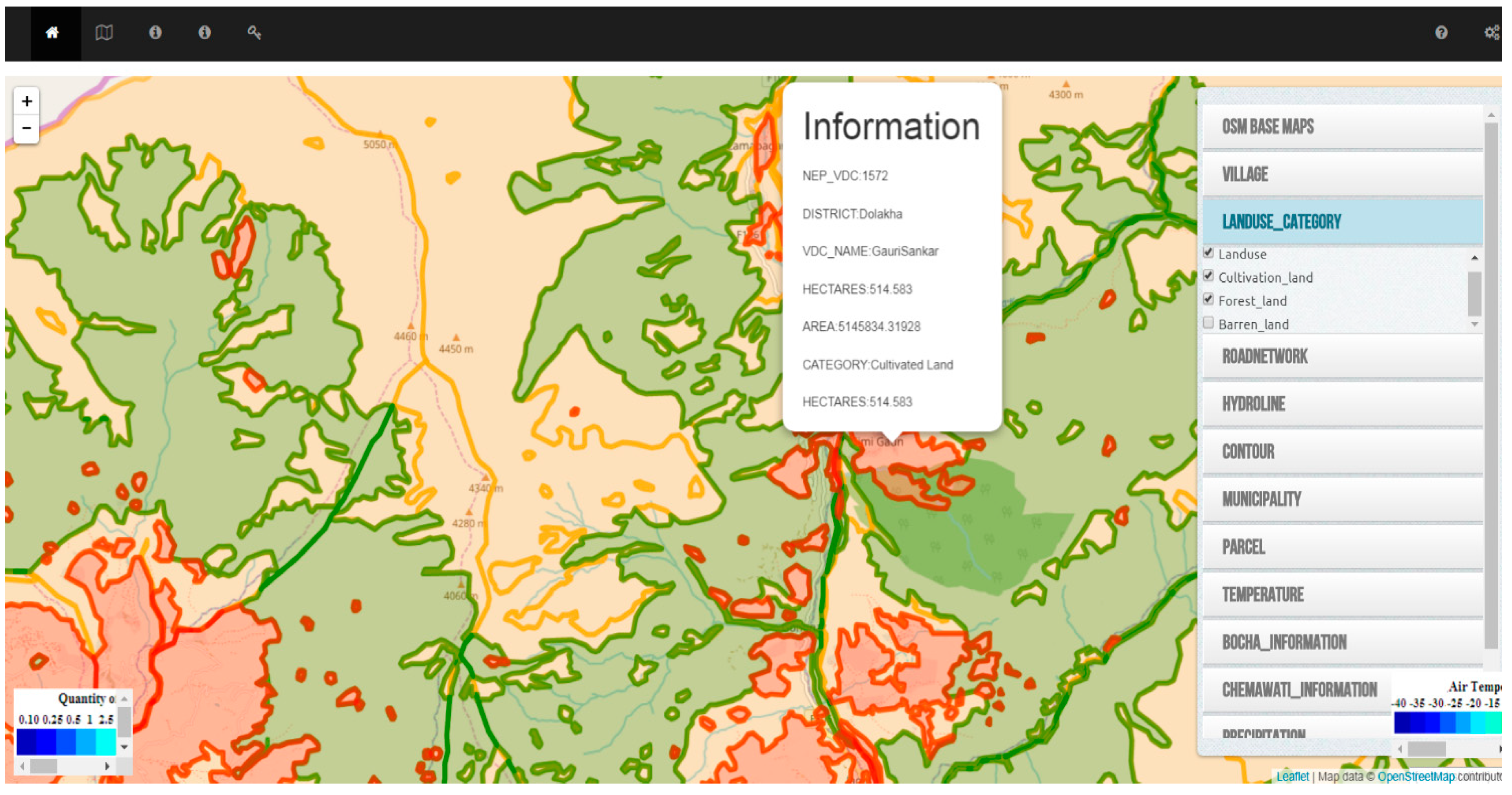
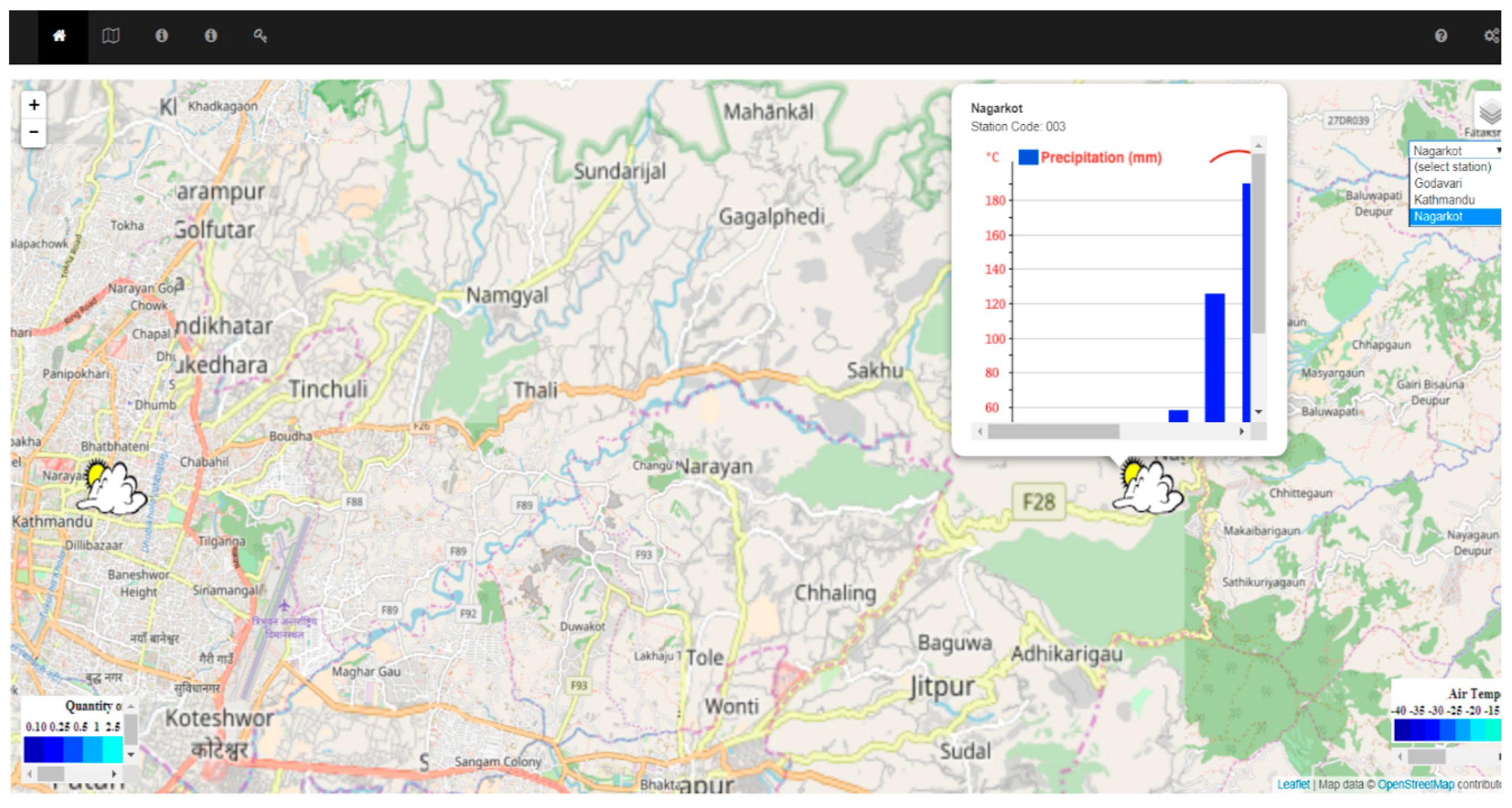
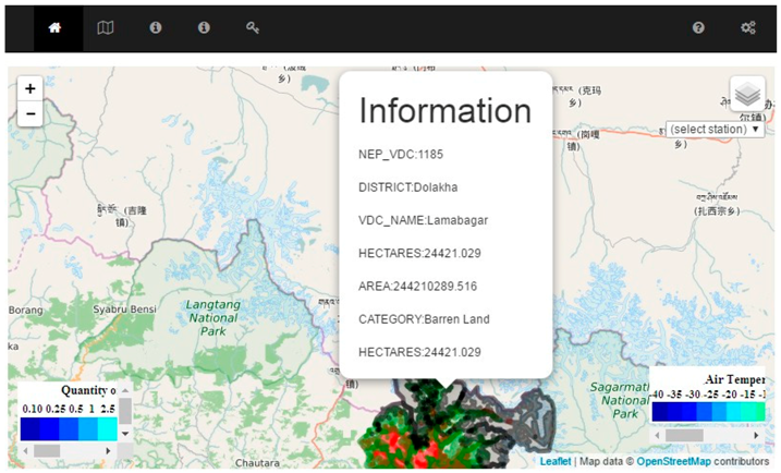
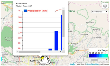
The users selected a specific layer and extracted information from its sub-layers. Turning on the sub-layers, land and climate data were presented on the base map. The participants could make queries by clicking on the map. A pop-up window showed information about the clicked point on the base map (Figure 4). When the participants selected a meteorological station, a ten year (2000–2010) rainfall and temperature graph appeared in MCAS (Figure 5). Land layers were interactive. The participants could combine different land layers and make queries about their desired location/s, zoom in/out, and apply pan functions to explore MCAS from parcel to Village Development Committee (VDC) to district levels. The advantage of combining land layers in an interactive environment and getting query compared to a static map was having an overview of the whole area to identify the information one needs. Moreover, the pop-up window of the spatial query contained detailed information of each location in a map layer.

4.2. Inclusive

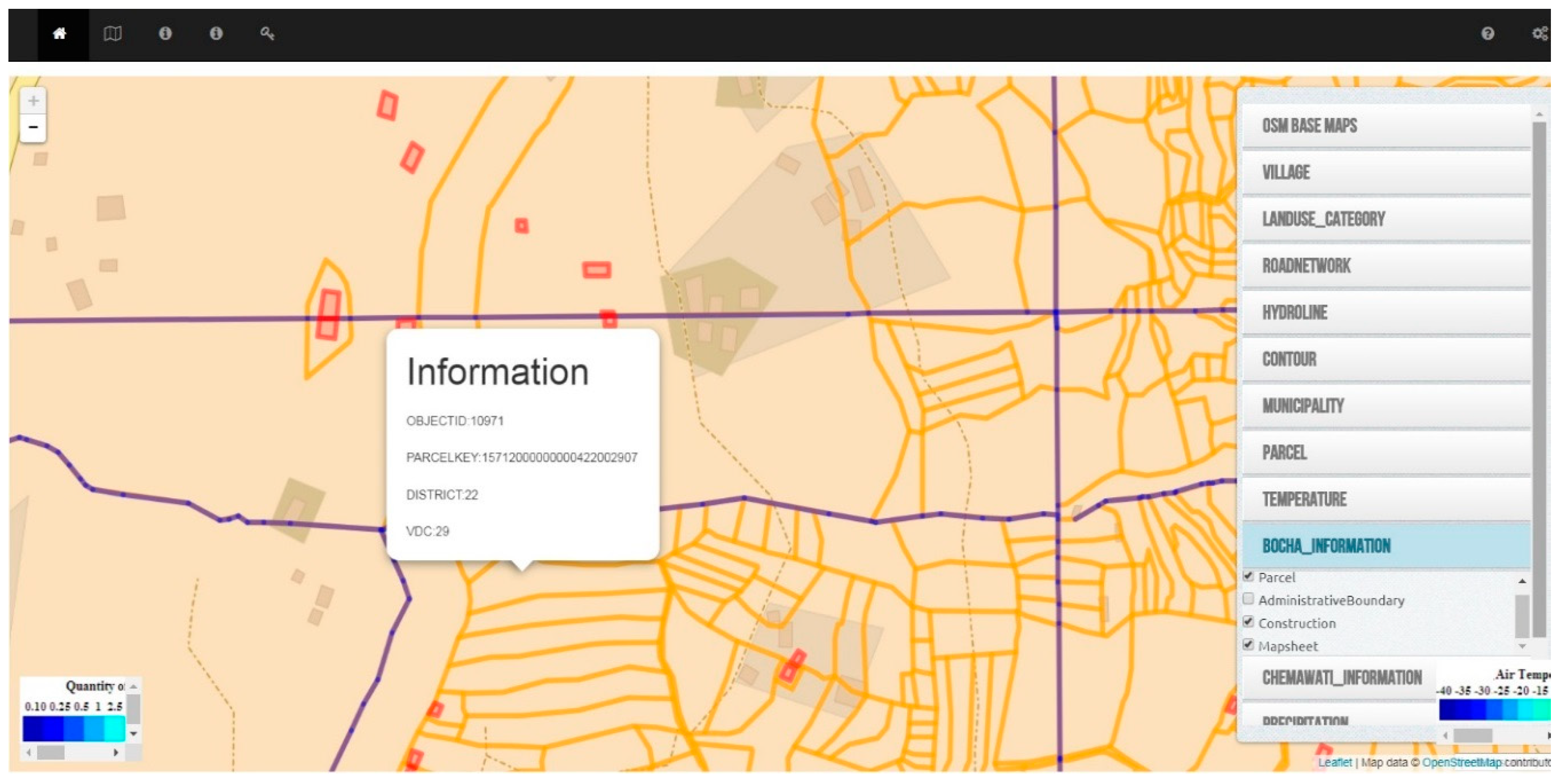
The adapted definition of Inclusive for MCAS indicated ‘including all types of land tenure that are relevant to CBA.’ Analysis of the user evaluation results did not reveal any code specifically related to inclusiveness. Furthermore, there was no evidence of types of land tenure in the system (Figure 6). The populated parcel maps in MCAS were collected from the DSO of Dolakha. “The cadastral based-map is sometimes incomplete” due to the technical problem including vectorization [42] but the data may include “size, value and legal rights” related to the parcel [43]. However, there may be other reasons including privacy to protect land information, and particularly tenure rights that remained uncovered. It was beyond this study to check this further and subsequently requires further research. The intention was to explore whether any land tenure was included as an attribute of a parcel that was relevant to CBA, for instance: tenancy. Therefore, based on the results of the user test the system is not yet considered to be inclusive. However, it is inclusive regarding the ability to provide a cross-cutting suit of datasets relevant to CBA, even if all tenures are not provided.

4.3. Participatory

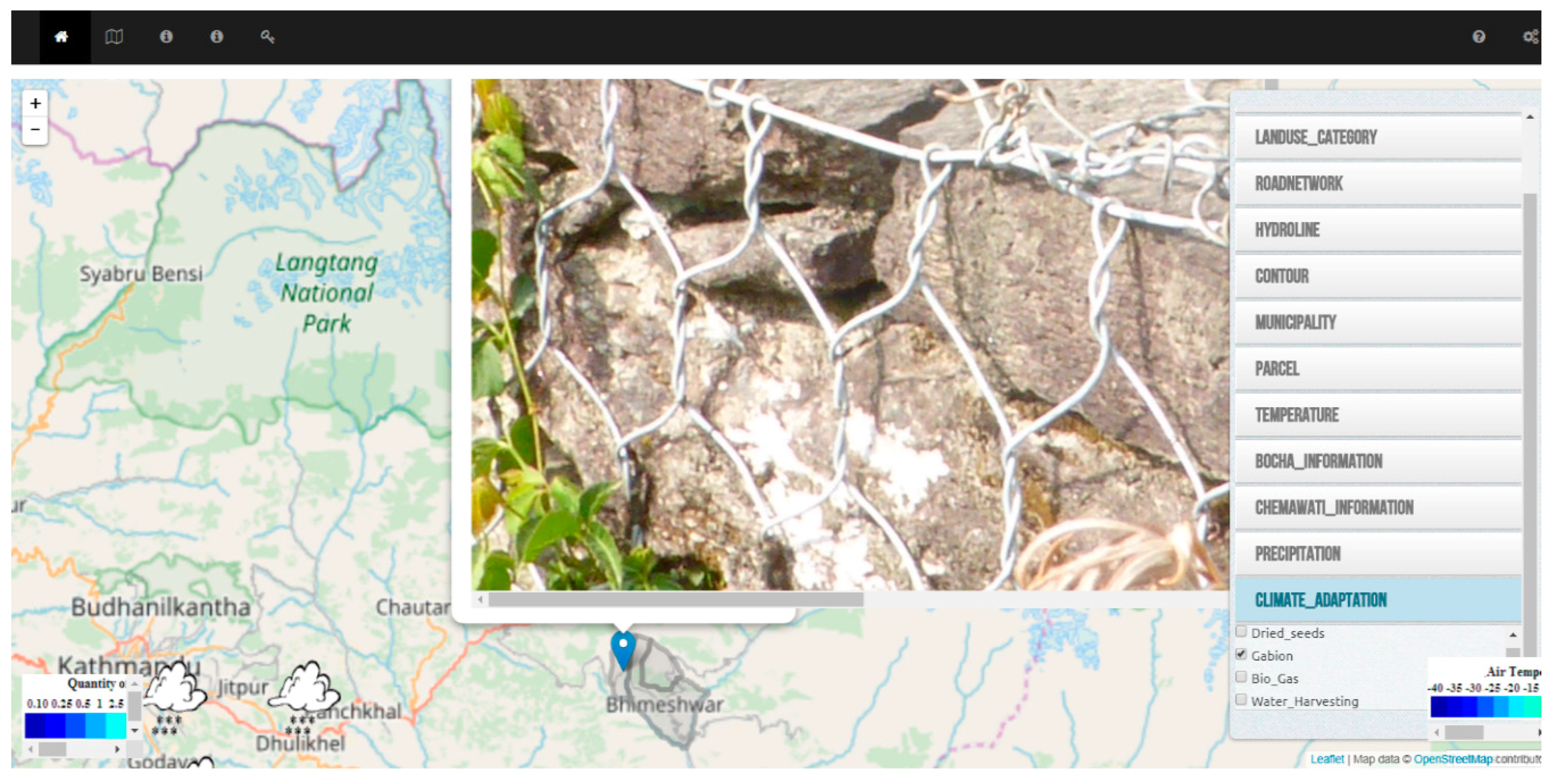
Two of the participants could fill in the observation form that was designed for the communities/individuals to share their experience about the impacts of climate change, time and the location of climate change events and their needs. The climate-adaptation layer created the opportunity for mountain communities/individuals to share a CBA option with an image as a “bottom-up” approach to support “crowdsourcing”. The system developer had already populated the climate-adaptation layer with some photos of adaptation options for the purposes of testing. Figure 7 represents the climate-adaptation layer. The climate-adaptation layer supports community/individual to be visible. The shared photos of climate-adaptation experiences provide information about the available resources and how to conduct a CBA to other communities/individuals. Based on the results, it is concluded that the system exhibits an ability to support “participation”, however, ideally the evaluation would be extended to include a field-based test enabling contribution of data by real community members. This represents an area for further inquiry.

4.4. Affordable

MCAS is developed as a research prototype using open-source software and with minimum available resources of system requirements and experts. All of the participants had free access to the data of meteorological stations, ten year rainfall, and temperature graph and layers in MCAS. The users needed a smartphone/laptop to retrieve information from MCAS. The MoLR as a governmental body has already established a LIS and has the capacity of incorporating different data and information from other organizations or agencies including DHM. Technical experts from diverse backgrounds are available for further development and operation of an LIS such as MCAS. However, since open data was used for MCAS prototyping, the feasibility of existing open data in scaling or implementation of the system should be considered. Besides, assuming that all users in remote areas have devices available to access MCAS, the cost of providing internet infrastructure across the country is high and this is a broader contextual limitation of the system. From all the points raised, MCAS can be considered somewhat affordable in the short term, and potentially affordable in the medium to long-term.

4.5. Reliable

An LIS is reliable when it represents its data through the spatial framework of FFP LA that requires the four principals of (1) having visible boundary; (2) using satellite images; (3) being accurate in the way of fulfilling the purpose of the system and (4) authorizing update and improvement of an LIS [24]. MCAS provides reliable land and climate information by following these principals. MCAS used Open Street Map as a base map that enabled embedding data layers in the system. Open Street Map is using satellite navigation system in providing geospatial data [45]. Furthermore, data layers visualized general boundaries of the study area and this qualifies for most LIS purposes, particularly in rural areas [22]. The displayed land and climate data in MCAS were accurate enough to fulfill the need of the users in identifying spatial objects, including land parcels and non-spatial objects such as rainfall and temperature graphs. MCAS could record changes of adaptation options through the sharing of images that update MCAS and provide incremental improvement in adaptation activities. According to all the aforementioned points MCAS can be considered to exhibit an inherent level of reliability.

4.6. Attainable

A mixture of an Agile-inspired approach and open-source software were put to use in MCAS development. A system runs with the minimum requirements in an Agile approach. Open-source software is usually available for IS development at limited or less time and cost. The implementation of Geo-ICT projects necessitates Internet access and installing its infrastructure. Also, Nepal mountain communities/individuals require PCs, laptops, or smartphones to access climate adaptation services as Geo-ICT services. In the absence of Internet service providers in Nepal’s rural areas, with existing telecenters only concentrated in places with high population—mostly in Katmandu [46] MCAS is currently not attainable in the study area. However, if a telecenter was to be set up in the study area—as would be expected in the medium term—MCAS could be considered attainable.

4.7. Upgradeable

MCAS was developed based on an Agile-inspired approach. This approach uses incremental development, based on the users’ feedback to improve the system. The component based nature of the design of any IS creates the possibility of utilizing plug-ins and tools as needed. For instance, adding a specific feature and customization to make IS more versatile. The climate-adaptation layer has the potential to assist the government in developing its climate change policies, both the Local Adaptation Plans for Action (LAPA) and National Adaptation Program of Action (NAPA), since it presents facts and evidence of a CBA. MCAS as a communication channel connects communities/individuals and the government to experience climate adaptation services. Overall MCAS is considered to exhibit levels of upgradability.
In summary, some of the FFP LA elements have not been fully satisfied in this study, but they have the potential to be achieved with further research and development.

5. Discussion

The development and evaluation results revealed much about current CBA implementation, the potential utility of MCAS, drawbacks and challenges for its actual implementation and scalability. This section focuses on three critical areas deemed the most important learnings from the study.

5.1. Lessons from the Design Process

Initially, the Agile-inspired approach was not considered for the work, however, its adoption is considered to have enhanced the final outcomes. The nature of the project appears to have fit well with the Agile philosophy: a minimum set of requirements, established from the analysis of FGI and the household survey among individuals, coupled with an experimental mindset meant the first iteration of the system was available within two weeks, and iterations thereof became available at a repeating two week increment. During the ongoing system development, a core team consisting of a IS technical developer, a land and climate change researcher, and a project advisor tested and simulated MCAS repeatedly. This enabled rapid and incremental improvements.
However, a key concern was that the feedback was simulated from the project team. That is, it was not possible to incorporate the feedback from the actual users during system development. The team members were not working directly at the test location due to their workload, schedule overlaps, and the time and cost involved with traveling to reach mountain communities and there was no direct or indirect contact with them. The distance between the development location and the actual test location and the lack of any ability to co-develop MCAS was a major drawback, although perhaps to be expected in this small-scale testbed environment. At any rate, any efforts to replicate or scale the design process used here would need to take this issue into account.
Also, on the design process, the use of online open data and open-source software was thought to have accelerated the development. Extensive coding and programming were not needed, and neither was going through the bureaucracy of collecting data from multiple organizations. For instance, rainfall and temperature data were collected from the DHM website, and Open Street Map was used as the base map. A base map is a crucial component—no LIS such as MCAS can function without it.
Another issue emerging during the development process related to the challenges of working in multi-disciplinary and multi-cultural research environments. As a base level differences in language and culture continually impacted upon decision making. Moreover, during the trials of MCAS, the priorities of each user were different based on their backgrounds and their objectives. The difference between scientific language among disciplines (e.g., IS vs. LA vs. climate change experts) in the development team is thought to have also delayed several advancements in the software. The costs and challenges of miscommunication and the translation efforts in working in this multi-national and multi-disciplinary context (e.g., translating CAPs language into IS requirements and Geo-ICT demands) were neither factored not costed in during the design process, but, need to be highlighter as a major challenge for future work.
Finally, whilst the Agile approach seeks to enable adding new features and functionality, the actual implementation of these changes was considered highly challenging. Adding new features to make the system flexible, and adding data layers or making spatial queries accessible were challenging aspects to incorporate. It is important to consider who would deliver these updates in a practical setting. Most likely there is a need for external support outside communities and government to do such maintenance, and this potentially undermines the community-orientation of the tool.

5.2. Remaining Challenges for the Tool

First, regarding content, the most requested layers and information included land-related layers, adaptation options, the location of meteorology stations and the rainfall and temperature graphs. As explained, these were certainly incorporated into MCAS, however, it is believed MCAS could be further developed to incorporate other datasets based on the feedback from the test users. However, this should be considered no small challenge: data acquisition and entry was more challenging than initially expected. Some of the collected data from different organizations, excluding open data, were defined in different coordinate systems, and needed transformation to be displayed correctly in the system. It was a challenging task to identify the proper coordinate system and to avoid parallax problems. Despite advances in automation and simplification of software tools, understanding and resolving this still demands a relatively high level of training and digital acumen. Further simplifying the process for adding new layers should be a future focus.
In terms of usability functionality, users tended to interact easily, if not seamlessly, with combined layers, a major challenge was loading the near-real time online climate data: processing and distributing the weather data points every second is only possible with a high-speed connection and most likely not realistic in the case location at the current time [47]. Additionally, the loaded near-online climate data layer covered the base map entirely, and since the layer was not visually transparent, the underlying layers became invisible: this was considered a major usability flaw, but one that could be easily overcome with further development. Another identified issue was that users could not retrieve the exact value of the rainfall or the temperature from either the static graph or the near-online climate data due to the nature of the data being vector and raster respectively. Solving this would need specific knowledge of coding or specialized software and tools [48,49]. Furthermore, the use of the English language embedded into MCAS, was recognized as a barrier of both the development and evaluation of system itself. Language is an issue that demands further thought and research with regards to MCAS. Whilst digital translation tools have rapidly matured and are more readily available for implementation in such web service oriented systems, the issue of dealing with mountain community members who are not proficient in English certainly demands more consideration. Overall, the prototype emphasis on a single language limited the use and users of MCAS, by excluding the users who are not proficient in English. Overall, the prototype emphasis on single language limited the use and users of MCAS, by excluding the users who are not proficient in English.
In terms of functionality, and specifically crowdsourcing interactions, the climate-adaptation layer was already populated with photos for system simulation as preparation for the actual user test. Therefore, the idea of the community uploading CBA photo was not really explored and implemented in a satisfactory manner and demands the contribution of data by real community members (Figure 7—Climate adaptation layer). In addition, MCAS was mainly tested on a desktop, and it is not clear whether some of the system functionalities including zoom in/out, pan and visualization of layers would work properly on a mobile device/smaller screen.
On affordability, developing MCAS was affordable as only a team of three experts was involved for two weeks to get the initial IS working. Simple functionalities were available early on in MCAS because it was designed and developed in the context of running an existing LIS. It was an ideal approach to facilitate and demonstrate proof of concept. The visual proof of concept represented the capability of the system. For instance, the climate-adaptation option layer provided specific information about CBA, the land-use category illustrated land information and the static climate graphs supplied information about rainfall and temperature. An Application Programing Interface (API) removed the challenges of translating the near-online temperature and rainfall data and embedding Open Street Map in MCAS. However, as already noted, to ensure that the design approach and developed system are scalable requires further investigation.

5.3. Institutional Opportunities and Challenges

Considering MCAS more broadly, in terms of institutional and policy implications, it is worth recalling that CBA is being integrated into National Adaptation Plans (NAPs) and sectoral policies, budgets, and planning frameworks to enhance community adaptive capacity [50]: tracking CBA is increasingly essential for identifying whether adaptation actions are achieving the desired results and whether to continue adaptation implementation. An LIS like MCAS can share local contributions with the national level regarding the goals defined by NAPs, NAPAs, and LAPAs in adaptation. The climate adaptation experiences shared via MCAS at the local level could aid tracking and measurement of adaptation activities. It could facilitate policy-makers in choosing adaptation policies and strategies, in addition to helping the national level in management and financial support of adaptation actions and reinforcing communities in learning about the implementation of various adaptation options.
Maintaining LIS components and contents was considered one of the major challenges with regards to technical infrastructure in developing countries [51]. Formulation and implementation of LIS is often challenged due to political instability and motivation, capacity, financial resources, and data availability [52]. Capacity constraints related to the development of IT experts and equipment, Geo-ICT infrastructure, update and system maintenance should also be considered in the implementation of any LIS including MCAS. Each CBA is conducted by an individual or a community in a specific place, and thus the particular parcel may be transacted or inherited to other person/s. It is complicated to identify when and how that happened and whether the new owner would like to continue conducting that particular CBA.
Evaluation results of MCAS show that mountain communities/individuals could get more from a LIS generally: a type of service that benefits both mountain communities/individuals and the government, rather than climate information services alone. Indeed, it can be considered a disappointment that the communities for which MCAS is intended do not have readily available access to land tenure security, let alone land tenure data, and even more so relevant climate change information. This is where demonstrators like MCAS provide opportunity: as a driver for climate change adaptation and as a supportive tool for enhancing land tenure security.

6. Conclusions

This paper assumes that MCAS as a LIS is a comprehensive way to provide information for CBA in rural mountain areas. An Agile-inspired approach was used to develop MCAS. The developed web-based LIS demonstrated the ability to integrate a variety of spatial and non-spatial information including land and climate change variables. User testing was firstly conducted by the development team and later with the actual users because of time limitation, budget, and resources. The FFP LA approach was used to evaluate MCAS. The result of the user test revealed the importance of MCAS in supporting climate adaptation services. It indicated that MCAS could provide land and climate change information together with various experiences of CBAs. The spatial side of LIS allowed users to explore their location in the context of land use, infrastructure, and available resources that can enhance CBA activities. Climate change data demonstrated changes in climate variables. The evaluation identified the potential ability of MCAS to be fit-for-purpose with respect to the climate change adaptation needs within a community. This new service has the potential to provide an incentive for communities/individuals that are at the frontier in implementing CBA. The limitations related to the implementation of the new services were identified particularly the lack of Geo-ICT infrastructure in the case area. Regardless of the aforementioned limitations, MCAS can still be considered as a factor in supporting development in rural mountain communities/individuals. It is further suggested that the land aspects of climate change should be added more explicitly to CBA initiatives.

Author Contributions

Conceptualization, all authors; Methodology, all authors; Software, A.K.; Validation, A.K.; Formal Analysis, A.K.; Data Curation, A.K.; Writing—Original Draft Preparation, A.K.; Writing—Review & Editing, all authors; Supervision, R.B. and J.Z.; Funding Acquisition, J.Z. All authors provided feedback and contributed to finalize the manuscript.

Funding

This research was funded by Erasmus Mundus Action 2 Project SALAM, International Scholarship of the European Commission.

Acknowledgments

This research paper was conducted at Faculty of Geo-Information Science and Earth Observation (ITC), University of Twente. We thank Pawan Tapa for his assistance with developing the system and conducting the user test in Katmandu, Nepal. It was a part of his internship trainee between Münster University and ITC faculty of Twente University. We would also like to show our gratitude to KU that has been supportive of the user test. We are grateful to all of the participants of the user test that greatly added value to the course of this study.

Conflicts of Interest

The authors declare no conflict of interest.

Appendix A. MCAS User Guide

1. Introduction
A mobile and web applications were built with the aim of providing information for the district, VDCs, NGOs, communities, and individuals. This system includes information about land and climate change, such as land use, administrative boundary, contour, hydro line, Cadastre, road network, near real-time temperature and precipitation, which support communities and individuals to access, visualize, and query information in a simple, easy, and better approaches.
2. Process/Workflow
  • Double-click on the index web page for opening the home page on the browser.
  • There is title bar on the top with the symbol, and name you can select map, license, home, help, and about us.
  • Click on the top left button Ijgi 07 00343 i001 zoom in/out, even you can scroll mouse for zooming in and out.
  • Click on the top right button Ijgi 07 00343 i002 for selecting layers such as land use categories, village, contour, Cadastre, administrative boundaries, temperature, and precipitation.
  • You can switch layers, overlay layers, and click for the popup that contains attribute.
  • Click on the button name, select, station for selecting three meteorological stations.
  • Click on the layer name, select, temperature and precipitation for knowing up-to-date temperature and precipitation.
3. Examples
  • Double-click on the index web page to open the home page on the browser. Ijgi 07 00343 i003
  • There is a title bar on the top with the symbols. You can select map, license, home, help, and about us. Ijgi 07 00343 i004
  • You can switch layers, overlay layers, and click for the popup that contains attribute. Ijgi 07 00343 i005
  • Click on the button name, select, station to select each of the three meteorological stations. Ijgi 07 00343 i006
  • When you click on the meteorological station such as Kathmandu, you can see monthly precipitation and temperature in a graph format. Ijgi 07 00343 i007
  • Click on the top right button for selecting layers such as land use categories, village, contour, cadastre, administrative boundaries, temperature, and precipitation. Ijgi 07 00343 i008

References

  1. Zheng, Y.; Dallimer, M. What motivates rural households to adapt to climate change? Clim. Dev. 2015, 1–12. [Google Scholar] [CrossRef]
  2. Ayers, J.; Forsyth, T. Community-Based Adaptation to Climate Change. Environ. Sci. Policy Sustain. Dev. 2009, 51, 22–31. [Google Scholar] [CrossRef] [Green Version]
  3. Sarzynski, A. Public participation, civic capacity, and climate change adaptation in cities. Urban Clim. 2015, 14, 52–67. [Google Scholar] [CrossRef]
  4. Pörtner, H.-O.; Karl, D.; Boyd, P.W.; Cheung, W.; Lluch-Cota, S.E.; Nojiri, Y.; Schmidt, D.N.; Zavialov, P.O.; Alheit, J.; Aristegui, J.; et al. Ocean systems. In Clim Chang 2014 Impacts, Adapt Vulnerability Part A Glob Sect Asp WGII Fifth Assess Rep IPCC; Drinkwater, K., Polonsky, A., Eds.; Cambridge University Press: Cambridge, UK, 2014. [Google Scholar]
  5. Syomiti, M.; Shelat, K.N.; Adaptation, T.S. Vulnerability of Agriculture, Water and Fisheries to Climate Change; Behnassi, M., Syomiti Muteng’e, M., Ramachandran, G., Shelat, K.N., Eds.; Springer: Dordrecht, The Netherlands, 2014. [Google Scholar]
  6. Regmi, B.R. Revisiting Community-Based Adaptation. Available online: wwwForestrynepalOrg (accessed on 5 January 2017).
  7. Heltberg, R.; Gitay, H.; Prabhu, R.G. Community-based adaptation: Lessons from a grant competition. Clim. Policy 2012, 12, 143–163. [Google Scholar] [CrossRef]
  8. King, S. Community-Based Adaptation: A Global Overview of CARE International’s Practice of Community-Based Adaptation (CBA) to Climate Change; CARE International: London, UK, 2014. [Google Scholar]
  9. Berrang-Ford, L.; Ford, J.D.; Paterson, J. Are we adapting to climate change? Glob. Environ. Chang. 2011, 21, 25–33. [Google Scholar] [CrossRef]
  10. Lieske, D.J. Coping with climate change: The role of spatial decision support tools in facilitating community adaptation. Environ. Model. Softw. 2015, 68, 98–109. [Google Scholar] [CrossRef]
  11. Gruen, A.; Murai, S. Special issue: Geomatics in mountainous areas—The International Year of the Mountains 2002. ISPRS J. Photogramm. Remote Sens. 2002, 57, 1–4. [Google Scholar] [CrossRef]
  12. Veregin, H.; Longley, P.A.; Goodchild, M.F.; Maguire, D.J.; Rhind, D.W. (Eds.) Data quality parameters. Geogr. Inf. Syst. 2005, 1, 177–190. Available online: http://www.geos.ed.ac.uk/~gisteac/gis_book_abridged/files/ch12.pdf (accessed on 5 July 2017).
  13. Sjoberg, R.W.; Horn, B.K. Atmospheric effects in satellite imaging of mountainous terrain. Appl. Opt. 1983, 22, 1702. [Google Scholar] [CrossRef] [PubMed] [Green Version]
  14. Fassnacht, K.S.; Cohen, W.B.; Spies, T.A. Key issues in making and using satellite-based maps in ecology: A primer. For. Ecol. Manag. 2006, 222, 167–181. [Google Scholar] [CrossRef]
  15. Ospina, A.V.; Heeks, R. ICTs and Climate Change Adaptation: Enabling Innovative Strategies. Strateg. Brief-1 Clim. Chang. Innov. ICTs Proj. 2011, 17, 1–9. [Google Scholar]
  16. Wamsler, C.; Brink, E. Moving beyond short-term coping and adaptation. Environ. Urban. 2014, 26, 86–111. [Google Scholar] [CrossRef] [Green Version]
  17. Bartoli, F.; Medaglia, C.M. GeoAvalanche—Spatial Data Infrastructure for avalanche awareness warning. In Proceedings of the 2012 FIG Working Week, Knowing to Manage the Territory, Protect the Environment, Evaluate the Cultural Heritage, Rome, Italy, 6–10 May 2012. [Google Scholar]
  18. Geopraevent, A.G. Geopraevent. 2017. Available online: http://www.geopraevent.ch/?lang=en (accessed on 2 August 2017).
  19. International Centre for Integrated Mountain Development (ICIMOD). Citizen Scientists Aid Winter Fog Study with Mobile App. 2016. Available online: http://www.icimod.org/?q=22713 (accessed on 1 January 2017).
  20. Food and Agriculture Organization (FAO). The Voluntary Guidelines on the Responsible Governance of Tenure of Land, Fisheries and Forests in the Context of National Food Security; Food and Agriculture Organization: Roma, Italy, 2012; Available online: http://www.fao.org/docrep/016/i2801e/i2801e.pdf (accessed on 5 January 2017).
  21. Mitchell, D.; Enemark, S.; van der Molen, P. Climate resilient urban development: Why responsible land governance is important. Land Use Policy 2015, 48, 190–198. [Google Scholar] [CrossRef]
  22. Enemark, S.; Bell, K.C.; Lemmen, C.H.J.; McLaren, R. Fit-For-Purpose Land Administration; Enemark, S., Ed.; World Bank and International Federation of Surveyors: Copenhagen, Denmark, 2015. [Google Scholar]
  23. International Federation of Surveyors (FIG). The Surveyor’s Role in Monitoring, Mitigating, and Adapting to Climate Change; International Federation of Surveyors: Copenhagen, Denmark, 2014. [Google Scholar]
  24. Enemark, S.; McLaren, R.; Lemmen, C. Fit-For-Purpose Land Administration Guiding Principles; Global Land Tool Network (GLTN): Copenhagen, Denmark, 2015. [Google Scholar]
  25. Eckstein, D.; Künzel, V.; Schäfer, L. Global Climate Risk Index 2018: Who Suffers Most from Extreme Weather Events? Weather-Related Loss Events in 2016 and 1997 to 2016. 2017. Available online: https://germanwatch.org/en/download/7170.pdf (accessed on 21 March 2018).
  26. Ministry of Environment. Climate Change Vulnerability Mapping for Nepal; Ministry of Environment: Kathmandu, Nepal, 2010.
  27. Khezri, A.; Bennett, R.; Zevenbergen, J. Defining the Requirements of an Information System for Climate Change Adaptation in the Mountain. MDPI-Clim. 2018, 6, 47. [Google Scholar]
  28. Dennis, A.; Haley Wixom, B.; Roth, M.R. System Analysis and Design, 5th ed.; Wiley: Hoboken, NJ, USA, 2012. [Google Scholar]
  29. Johannessen, L.K.; Ellingsen, G. Integration and generification-agile software development in the healthcare market. Comput. Support. Coop. Work 2009, 18, 607–634. [Google Scholar] [CrossRef]
  30. Moe, N.B.; Dingsøyr, T.; Dybå, T. A teamwork model for understanding an agile team: A case study of a Scrum project. Inf. Softw. Technol. 2010, 52, 480–491. [Google Scholar] [CrossRef] [Green Version]
  31. Meso, P.; Jain, R. Agile Software Development: Adaptive Systems Principles and Best Practices. Inf. Syst. Manag. 2006, 23, 19–30. [Google Scholar] [CrossRef] [Green Version]
  32. Dingsøyr, T.; Nerur, S.; Balijepally, V.; Moe, N.B. A decade of agile methodologies: Towards explaining agile software development. J. Syst. Softw. 2012, 85, 1213–1221. [Google Scholar] [CrossRef]
  33. Schwaber, K. Agile Project Management with Scrum; Microsoft Press: Redmond, WA, USA, 2004; Available online: http://www.amazon.com/dp/073561993X (accessed on 9 February 2017).
  34. Barton, J.E.; Goldie, X.H.; Pettit, C.J. Introducing a usability framework to support urban information discovery and analytics. J. Spat. Sci. 2015, 60, 311–327. [Google Scholar] [CrossRef]
  35. Beck, K. Extreme Programming Explained: Embrace Change; Addison-Wesley Longman: Boston, MA, USA, 2000. [Google Scholar]
  36. Misra, H. Users’ computer human interface capabilities in information system development life cycle: An organizational perspective. In Proceedings of the 2008 IEEE International Engineering Management Conference, Estoril, Portugal, 28–30 June 2008; pp. 1–5. [Google Scholar]
  37. DeLone, W.H.; Mclean, E.R. The DeLone and McLean Model of Information Systems Success: A Ten-Year Update. J. Manag. Inf. Syst. 2003, 19, 9–30. [Google Scholar] [Green Version]
  38. Bennett, R.; Alemie, B.K. Fit-for-purpose land administration: Lessons from urban and rural Ethiopia. Surv. Rev. 2016, 48, 11–20. [Google Scholar] [CrossRef]
  39. Bryman, A. Social Research Methods, 5th ed.; Oxford University Press: Oxford, UK, 2016. [Google Scholar]
  40. Guest, G.; Namey, E.E.; Mitchell, M.L. Participant Observation; Sage Publications: London, UK, 2013; pp. 75–112. [Google Scholar]
  41. Bugs, G.; Granell, C.; Fonts, O.; Huerta, J.; Painho, M. An assessment of Public Participation GIS and Web 2.0 technologies in urban planning practice in Canela, Brazil. Cities 2010, 27, 172–181. [Google Scholar] [CrossRef]
  42. Hammoudi, K.; Dornaika, F.; Soheilian, B.; Paparoditis, N. Extracting Wire-Frame Models of Street Facades From 3D Point Clouds and the Corresponding Cadastral Map. IAPRS 2010, 38, 91–96. [Google Scholar]
  43. Zevenbergen, J. A Systems Approach to Land Registration and Cadastre. Nord. J. Surv. Real Estate Res. 2004, 1, 11–24. [Google Scholar]
  44. Campelo, N.D.S.; Santoro Filho, M.J.G.; Valadares, O.C.D.P.; Paes, M.D.D.C.; Aragão, A.F. Georeferenced monitoring of displacements of gabion walls. Geotech. Eng. 2018, 171, 64–77. [Google Scholar] [CrossRef] [Green Version]
  45. OpenStreetMap. 2017. Available online: https://en.wikipedia.org/wiki/OpenStreetMap (accessed on 1 January 2017).
  46. Thapa, D.; Sæbø, Ø. Demystifying the possibilities of ICT4D in the mountain regions of Nepal. In Proceedings of the 2011 44th Hawaii International Conference on System Sciences, Kauai, HI, USA, 4–7 January 2011; pp. 1–10. [Google Scholar]
  47. OpenWeatherMap. Open Weather Map. 2017. Available online: https://openweathermap.org/technology (accessed on 12 November 2017).
  48. Li, B.; Griffith, D.A.; Becker, B. Spatially simplified scatterplots for large raster datasets. Geo-Spat. Inf. Sci. 2016, 19, 81–93. [Google Scholar] [CrossRef]
  49. Kumar, V.; Bansal, A.; Muttoo, S.K. Hiding Information in Vector Layer While Extracting Layers from Raster Data. Inf. Secur. J. 2012, 21, 317–327. [Google Scholar] [CrossRef]
  50. Cimato, F.; Mullan, M. Adapting to Climate Change: Analysing the Role of Government; Department for Environment Food & Rural Affairs: London, UK, 2010; p. 78. [Google Scholar]
  51. Simbizi, D.M.C. Measuring Land Tenure Security: A Pro-Poor Perspective; University of Twente Faculty of Geo-Information and Earth Observation (ITC): Enschede, The Netherlands, 2016. [Google Scholar]
  52. Furuholt, B.; Wahid, F.; Sæbø, Ø. Land information systems for development (LIS4D): A neglected area within ICT4D research? In Proceedings of the 2015 48th Hawaii International Conference on System Sciences, Kauai, HI, USA, 5–8 January 2015.
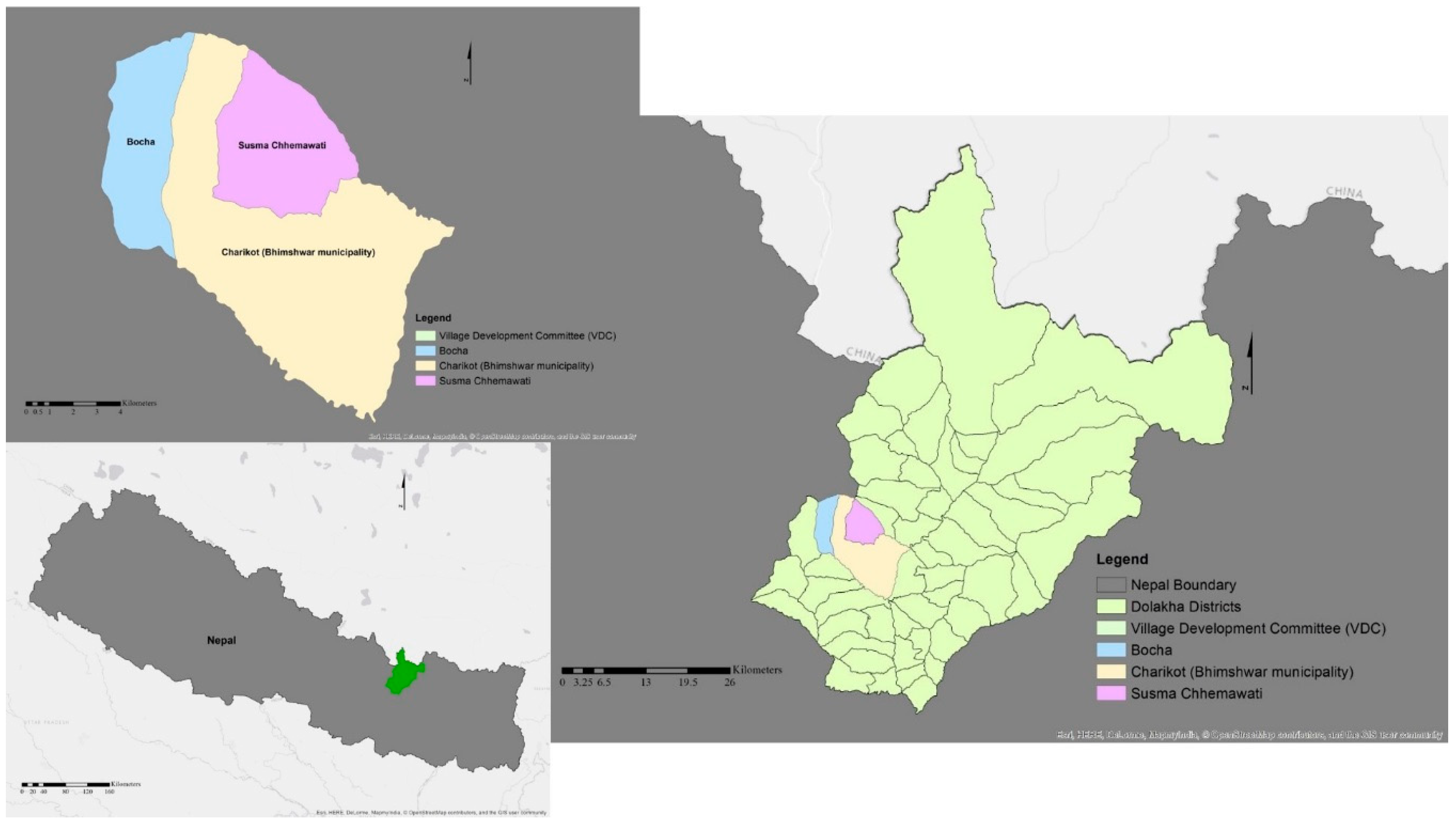
Figure 1. Case study location.
Ijgi 07 00343 g001
Figure 2. Mountain Community Adaptive System (MCAS) development process.
Ijgi 07 00343 g002
Figure 3. MCAS system architecture.
Ijgi 07 00343 g003
Figure 4. Selected layer and result of a query. A user could select the desired layer from the right panel that included base-map, villages and municipalities and their administrative boundaries, land-use category (land use, cultivation, forest, and barren areas), road network, hydro lines, contour or topographic map, land parcels, information about three Village Development Committees (VDCs), adaptation options and rainfall and temperature data. The user could zoom in/out on the map via the +/− buttons located at the top left-hand side (this function also applies to other figures that were presented in this study). In this figure, a user already selected sub-layers of the land-use category that were shown on the map in red, green, and orange colors. Since a user could make a query by clicking on the map, the pop-up window revealed information about the clicked location including the name of the district, name of the VDCs and its assigned code, land use category and its area in hectares.
Ijgi 07 00343 g004
Figure 5. Rainfall and temperature graph. A user could select the desired meteorology station from the top right-side panel that included the three meteorology stations of Godavari, Kathmandu, and Nagarkot. In this figure, a user selected the Nagarkot station. A pop-up window displayed information about the temperature and rainfall of 10 years. Both the temperature and the rainfall information were shown in one graph. The Y-axis illustrated annual temperature in °C, and the X-axis visualized yearly rainfall in mm for the selected location. It displayed climate information related to that particular meteorology station. Based on the aforementioned information in this paragraph, it is concluded that the system exhibited a level of flexibility.
Ijgi 07 00343 g005
Figure 6. Parcel information layer. A user could select the information about a VDC from the top right-side panel. In this figure, a user selected sub-layers of the Bocah information layer that consisted of the parcel (orange lines), construction area (red blocks), and map sheet (purple lines). The user made a query by clicking on the map. The pop-up window revealed information about the parcel including object ID, parcel key, district and VDC code. The displayed information provided parcel attributes, but no layered information about land tenure.
Ijgi 07 00343 g006
Figure 7. Climate-adaptation layer. A user could select the climate-adaptation layer from the right panel and overlay it with other layers. The climate-adaptation layer consisted of different adaptation options (CBA) that the user could choose from. This figure shows how the user overlaid an adaptation option (gabion) from the climate-adaptation layer with the municipality layer. Gabion is an iron-made basket that is filled with sand and soil to protect and to stabilize slopes from erosion [44]. Bocha communities installed gabion walls as a climate adaptation option to protect roads and buildings from landslides. A user takes advantage by seeing CBAs in other places. This layer can provide information about who is doing what regarding CBA, where, and how, it can be combined with other land layers. Furthermore, a user can compare different CBAs to see if any of them align with the available resources or skills in the current location. The layer was already populated with some adaptation option photos for the user test, and enabled a user to upload and share their CBA options in MCAS. The climate-adaptation layer overall facilitates the implementation of an adaptation option in other locations and hence is concluded to be participatory.
Ijgi 07 00343 g007
Table 1. Web-based and mobile applications that provide services to citizen.
App NameApp DomainApp InformationWebpage **Open Source Software
MySeasons *BiodiversityMonitoring vegetation phenologyhttp://myseasons.eu/CITnet
Atmos *WeatherProviding short-term predictions on current meteorological conditionshttp://beja.m-iti.org/web//GitHUb
CITnet
Protar.org *Land coverProviding land cover change in protected areas across Europehttp://www.protar.org/GitHUb
CITnet
Geoss2go *MappingDigital field mapping of tourism, agriculture and risk managementhttp://moovida.github.io/geoss2go/GitHUb
CITnet
CALIOPE EU *Air quality, air pollutionForecasting 48-h air quality over Europehttp://www.bsc.es/caliope/en?language=enCITnet
Fog WatchWeatherPresenting the presence and intensity of foghttp://www.icimod.org/?q=22713NA
** Access date to all web pages is 28 July 2018.
Table 2. Open source tools used for the development of MCAS.
Open Source Tools VersionFunctionSource
Quantum GIS (QGIS)2.18.3Create, edit, visualize, analyze and publish spatial datahttp://www.qgis.org/en/site/
Geographic JavaScript Object Notation (GeoJSON)RFC 7946Encoding geographic data featurehttp://geojson.org/geojson-spec.html#introduction
Leaflet0.7.7JavaScript library http://leafletjs.com/
Bootstrap3.3.7HTML, CSS, and JS frameworkhttp://getbootstrap.com/
JavaScriptECMAScriptCoding languagehttps://www.javascript.com/
jQueryCore 3.0Feature-rich JavaScript libraryhttps://jquery.com/
Table 3. Adapted elements of Fit-For-Purpose Land Administration (FFP LA) to MCAS.
Elements of FFP LAAdapted to MCAS
‘Flexible in capturing the spatial data.Flexible in capturing spatial and non-spatial land and climate change data.
Inclusive in scope to cover all tenure and all land.Inclusive of all types of land tenure that are relevant to Community-Based Adaptations (CBAs).
Participatory in approach to data capture and use to ensure community support.Participatory in sharing information about the effects of climate change on their land and livelihoods, and implementation of current CBA.
Affordable for the government to establish and operate, and for society to use.Affordable for the community/individual to invest in relevant technology devices and supportive infrastructure to access the provided services.
Reliable in terms of information that is authoritative and up-to-date.Reliable not only regarding cadastral data, but also for climate adaptation services.
Attainable in relation to establishing the system within a short timeframe and within available resources.Attainable to provide climate adaptation services in short time.
Upgradeable with regards to incremental upgrading and improvement over time in response to social and legal needs and emerging economic opportunities.’ [22].Upgradable regarding the community/individual’s needs to facilitate CBA.
Table 4. Participation statistics.
PlaceProfessionAgeEducationGender
Rural area 7
Urban area 2
City 3
Farmer 4
Student 6
Businessman 1
Housewife 1
Average 27
Maximum 38
Minimum 21
Literate 6
Illiterate 6
Male 6
Female 6