Ex Post Impact Assessment of Master Plans—The Case of Shenzhen in Shaping a Polycentric Urban Structure


Abstract
:1. Introduction
2. Materials and Methods
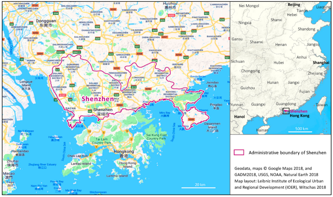
2.1. The Case Study
2.2. Materials
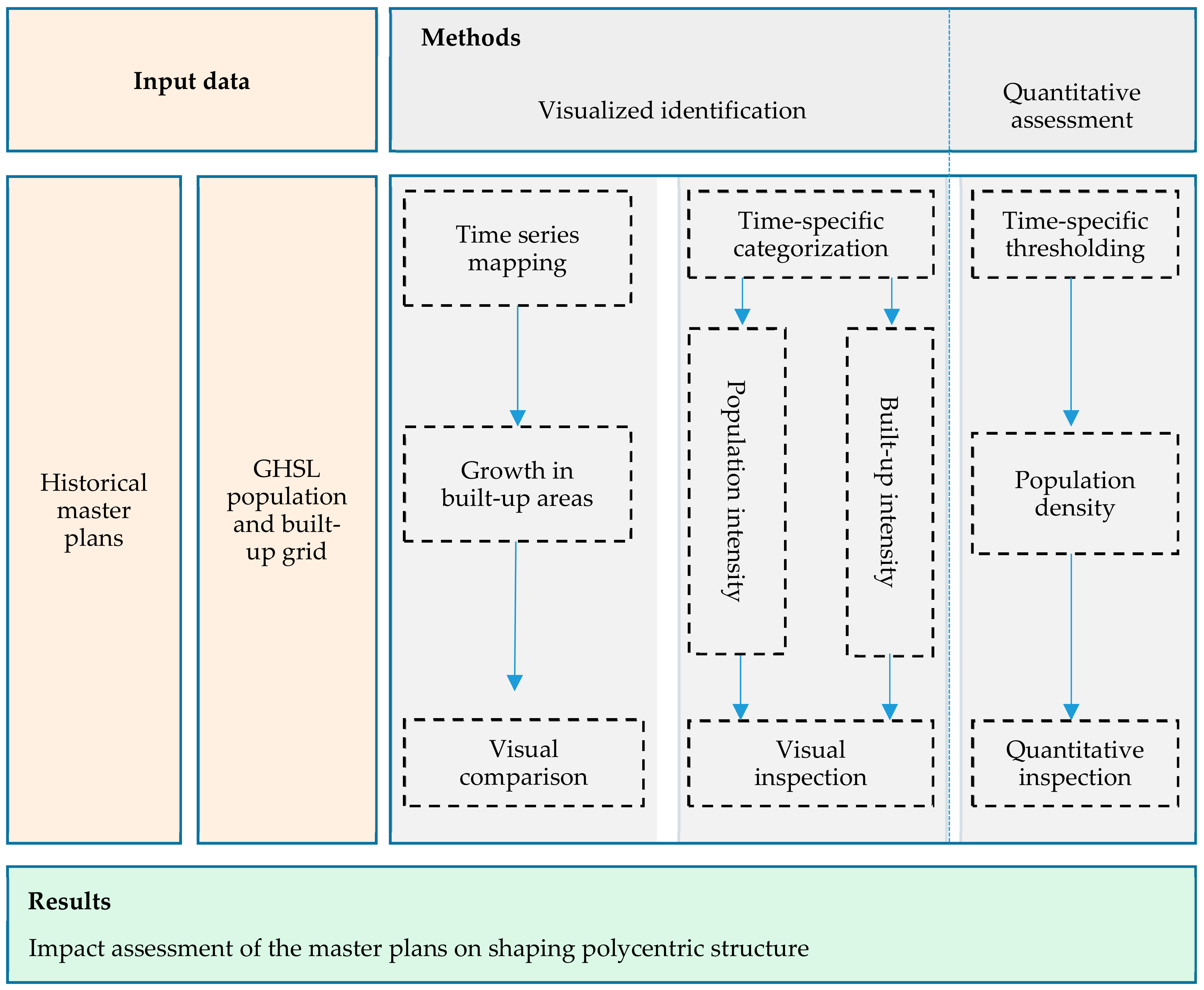
2.3. Methodical Framework
- (1)
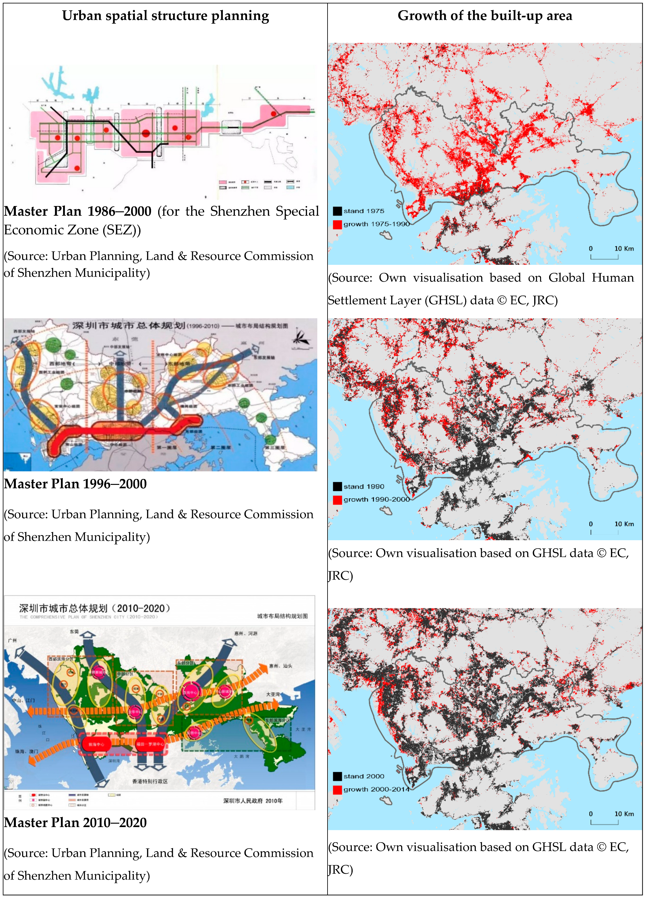
- The identification of development trends based on a comparison of the development goals of master plans and the actual spatial expansion in built-up areas using GIS time series mapping. This step is achieved by comparing the selected master plans and the expansion of built-up areas over time. A considerable period of time is required to prepare each master plan: For instance, while the master plan 2010–2020 for Shenzhen was finalized in August 2008 after two years of preparation, it was only officially approved by China’s State Council in August 2010. Therefore, the comparison did not seek to achieve complete consistency over time but rather aimed to compare similar time points and periods.
- (2)
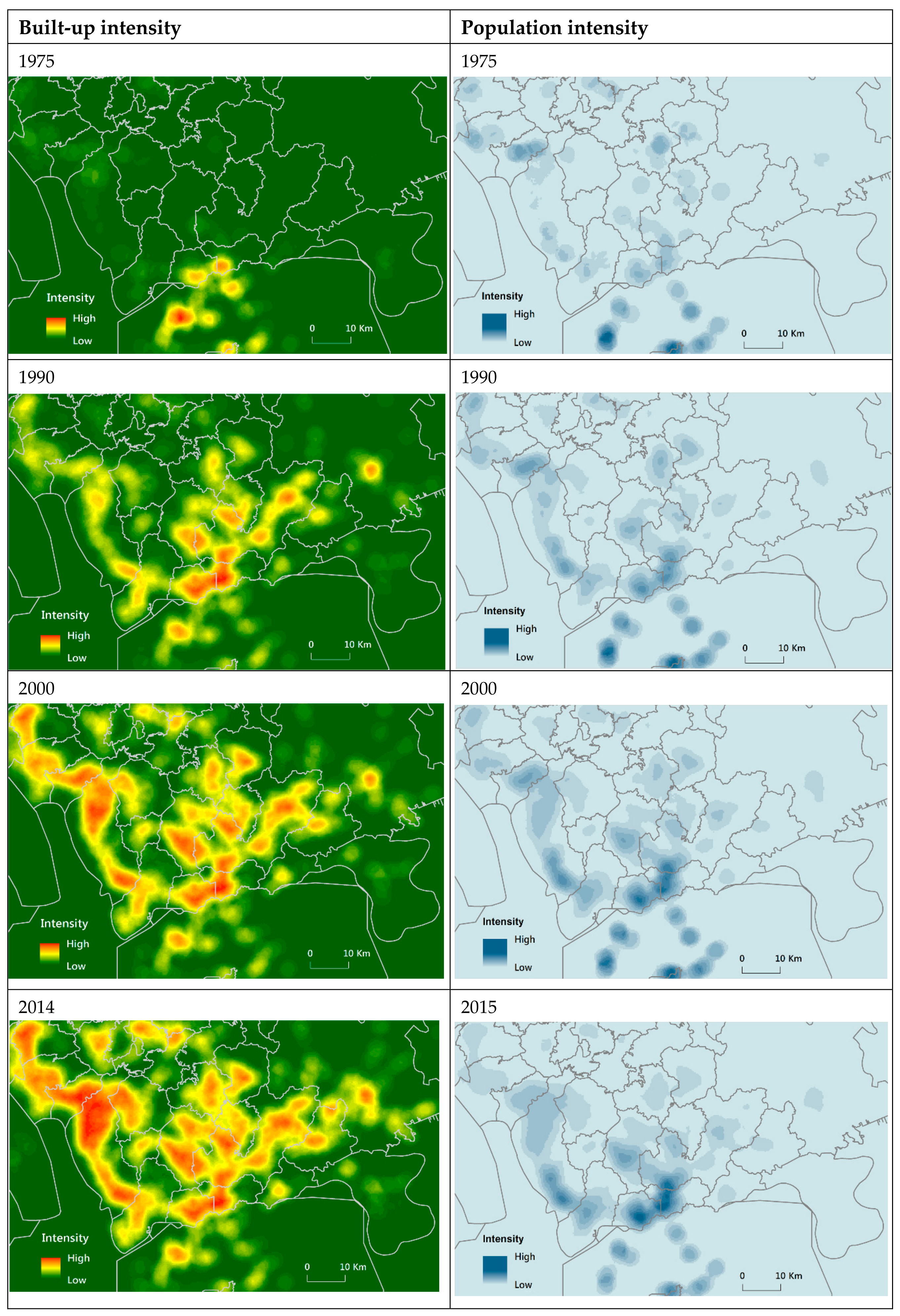
- Visual inspection of polycentricity using time-specific categorization to map the spatial-temporal changes in population and intensity. Considering the diversity of the discourse in regard to polycentricity, we defined morphological polycentricity as places of spatial densification, in accordance with the notions of Riguelle et al. [43] and Taubenböck et al. [56]. In this latter study, polycentricity was defined as a spatial pattern featuring more than one centre within a defined area [56] (p. 42). Taking into account the consistency and comparability of data for the case study city of Shenzhen, which has undergone rapid urban development over a long period of time, the focus here was on two basic indicators: population density and built-up areas. We applied a set of intensity maps extracted from the GHSL data to describe the spatial distribution of the population intensity and the built-up intensity in respective time nodes, i.e., the years 1975, 1990, 2000 and 2014/2015.
- (3)
- The application of time and city specific thresholding to assess spatial-temporal changes in population concentrations. We considered locations of high population density as proxies to demarcate urban centres. In this paper, we used (sub-)centres as areas of high urban concentration (in short hUC) based on the availability, consistency and comparability of data. Here, we assumed that a (sub-)centre shows hUC—the greater the number of such areas, the higher the degree of polycentricity. The population densities were calculated on a grid with s cell size of 1 sq km. The quantitative assessment drew on the fundamental logic of Greene’s method [36] using a basic set of reference thresholds (cut-offs) specific to the case study city and at the same time, which reflect the temporality of different phases of urban development. Since Shenzhen has applied a unified urban planning regulation, Shenzhen Urban Planning Standards and Guidelines, since 1997, we adopted relevant indicators in this regulation to define our reference values. In this document, the floor space ratio was the main indicator for determining density. Hence, according to the index for the floor space ratio of residential areas in Shenzhen Urban Planning Standards and Guidelines, we defined the ratio of the upper limit (a floor space ratio of 6) and the reference value (a floor space ratio of 1.5) as the reference threshold (density-based cut-off), giving a value of 4 to define a high urban concentration (hUC). Considering the index for the floor space ratio of residential and other land uses as well as corrective factors, we defined three degrees of high urban concentration as follows: high urban concentration level I (abbr. hUCI) with a cut-off value of 4 times the mean population density; high urban concentration level II (abbr. hUCII) with a cut-off value of 6 times the mean population density; high urban concentration level III (abbr. hUCIII) with a cut-off value of 8 times the mean population density.
3. Screening and Scoping
- 1980 “Overall Plan for the Planning and Construction of Shenzhen City”: This plan designated an area of 327.5 sq km for the SEZ and 60 sq km for the built-up area of Shenzhen city. The plan forecast a population of 300,000 by the year 1990, rising to 600,000 by the year 2000. The plan’s focus for urban development was an industry-led, industrial and agricultural combined SEZ and a new type of border city.
- 1982 “Outline of the Social Economic Development Plan for Shenzhen Special Economic Zone”: This plan extended the 1980 plan in terms of urban development and positioned Shenzhen as a comprehensive special economic zone with a strong industrial base supported by commercial, agricultural, housing and tourism development. Population forecasts were adjusted upwards to 250,000 by the year 1985; 400,000 by the year 1990; and 800,000 by the year 2000. The plan was the first to propose a polycentric linear-clustering spatial structure for the Shenzhen SEZ. This plan was partly revised in 1983 based on developments at the time. However, the unexpectedly rapid development meant that the goals set out in the plan for 1985 were already far exceeded by 1984.
- 1986 “Master plan of Shenzhen Special Economic Zone 1986–2000”: The plan revised the projections of the previous plan to a population of 1.1 million by the year 2000 and an urban built-up area of 123 sq km. Although this plan still regarded the Shenzhen SEZ as the main focus of urban planning, it went beyond the scope of the designated SEZ to determine a more advanced framework for infrastructure construction. The polycentric linear-clustering spatial structure for the Shenzhen SEZ foreseen in the 1982 plan was extended in the revised plan. In addition, the 1982 development focus was enlarged to an industry-led, export-oriented, multi-functional, highly developed comprehensive economic zone.
- 1989 “The Urban Development Strategy of Shenzhen City”: Since the previous planning-led urban development was largely centred on the Shenzhen Special Economic Zone, this led to a problem of unbalanced development within and outside the SEZ. In view of the unbalanced development due to disparate property rights of urban vs. rural land as well as the contrasting conditions within and outside the SEZ, the plan, for the first time, considered the entire administrative area of Shenzhen. Correspondingly, the spatial development strategy was positioned as a city-wide development and progressive urban expansion. The urban built-up area was extended to 150 sq km, and the expected population was adjusted upwards to 1.5 million by the year 2000.
- 1996 “Shenzhen Master Plan 1996–2010”: This plan was concerned with the entire administrative area of Shenzhen city, i.e., 2020 sq km. By the year 2000, the urban built-up area was estimated to cover 380 sq km with a population of 4 million. By 2010, the urban built-up area was expected to be 480 sq km for a maximum population of 5.1 million. The plan proposed a polycentric clustering structure along axes and corridors.
- 2006 “Shenzhen Urban Development Strategy 2030”: This was the first strategic urban plan for Shenzhen. By identifying urban development problems, this goal-oriented plan aimed to “strengthen the city centre, stretch toward both wings, penetrate north and south, connect the west part and expand eastward” as a strategy to create a polycentric urban spatial structure.
- 2010 “Shenzhen Master Plan 2010–2020”: This plan’s objective was to limit the growing population to 11 million and the urban built-up area to 890 sq km by the year 2020. The polycentric urban spatial structure proposed by the previous plans was continued and refined into “polycentric development in accord with the three axes and two corridors”.
4. Analysis and Discussion
5. Conclusions and Recommendations
Author Contributions
Funding
Conflicts of Interest
References
- UN-Habitat III. New Urban Agenda. United Nations: Quito, Equador, 2017; ISBN 9789211327311. Available online: http://habitat3.org/wp-content/uploads/NUA-English.pdf (accessed on 20 June 2018).
- Lichfield, N.; Kettle, P.; Whitbread, M. Evaluation in the Planning Process, 1st ed.; Pergamon: Oxford, UK, 1975; ISBN 9781483137278. [Google Scholar]
- Alexander, E.R.; Faludi, A. Planning and plan implementation: Notes on evaluation criteria. Environ. Plan. B Plan. Des. 1989, 16, 127–140. [Google Scholar] [CrossRef]
- Khakee, A. Evaluation and planning: Inseparable concepts. Town Plan. Rev. 1998, 69, 359–374. [Google Scholar] [CrossRef]
- Guba, E.G.; Lincoln, Y.S. Fourth Generation Evaluation; Sage: Newbury Park, CA, USA, 1989. [Google Scholar]
- Baer, W.C. General plan evaluation criteria: An approach to making better plans. J. Am. Plan. Assoc. 1997, 63, 329–344. [Google Scholar] [CrossRef]
- Alexander, E.R. Where do we go from here: Evaluation in spatial planning in the post-modern future? In Evaluation in Planning: Facing the Challenge of Complexity; Lichfield, N., Barbanente, A., Borri, D., Khakee, A., Prat, A., Eds.; Kluwer: Dordrecht, The Netherlands, 1989; pp. 355–374. [Google Scholar]
- Alexander, E.R. Evaluation in Israeli spatial planning. In Evaluation in Planning: Facing the Challenge of Complexity; Lichfield, N., Barbanente, A., Borri, D., Khakee, A., Prat, A., Eds.; Kluwer: Dordrecht, The Netherlands, 1998; pp. 299–310. [Google Scholar]
- Lichfield, N.; Prat, A. Linking ex-ante and ex-post evaluation in British town planning. In Evaluation in Planning: Facing the Challenge of Complexity; Lichfield, N., Barbanente, A., Borri, D., Khakee, A., Prat, A., Eds.; Kluwer: Dordrecht, The Netherlands, 1998; pp. 283–298. [Google Scholar]
- Berke, P.R.; Conroy, M.M. Are we planning for sustainable development? An evaluation of 30 comprehensive plans. J. Am. Plan. Assoc. 2000, 66, 21–33. [Google Scholar] [CrossRef]
- Ng, K.M.; Xu, J. Development control in post-reform China: The case of Liuhua Lake Park, Guangzhou. Cities 2000, 17, 409–418. [Google Scholar] [CrossRef]
- Hoch, C.J. Evaluating plans pragmatically. Plann. Theory 2002, 1, 53–75. [Google Scholar] [CrossRef]
- Ng, K.M. Sustainable urban development issues in Chinese transitional cities: Hong Kong and Shenzhen. Int. Plan. Stud. 2002, 7, 7–36. [Google Scholar] [CrossRef]
- Ren, W.; Zhong, Y.; Meligrana, J.; Anderson, B.; Watt, E.W.; Chen, J.; Leung, H.L. Urbanization, land use and water quality in Shanghai, 1947 to 1996. Environ. Int. 2003, 39, 649–659. [Google Scholar] [CrossRef]
- Oliveira, V.; Pinho, P. Evaluation in Urban Planning: Advances and Prospects. J. Plan. Lit. 2010, 24, 343–361. [Google Scholar] [CrossRef]
- Wageningen University & Research. Available online: https://www.wur.nl/en/project/ex-post_evaluation.htm (accessed on 20 June 2018).
- Koomen, E.; Dekkers, J.; Broitman, D. Analyzing and Simulating Urban Density Exploring the Difference between Policy Ambitions and Actual Trends in the Netherlands. In Spatial Analysis and Location Modeling in Urban and Regional Systems; Thill, J.C., Ed.; Springer: Berlin, Germany, 2018; pp. 145–172. [Google Scholar]
- Royal Town Planning Institute. Why the New Urban Agenda Matters to Planning, Planners and Governments. Available online: http://www.rtpi.org.uk/media/2276458/trudi_elliott_article.pdf (accessed on 20 June 2018).
- Xie, Y.; Costa, F.J. Urban planning in socialist China: Theory and practice. Cities 1993, 10, 103–114. [Google Scholar] [CrossRef]
- UN Habitat. State of the World’s Cities Reports. Available online: https://unhabitat.org/collection/state-of-the-worlds-cities-report/ (accessed on 20 June 2018).
- Wei, Y.D. Planning Chinese cities: The limits of transitional institutions. Urban Geogr. 2005, 26, 200–221. [Google Scholar] [CrossRef]
- Friedmann, J. China’s Urban Transition, Minneapolis; University of Minnesota Press: Minneapolis, MN, USA, 2005. [Google Scholar]
- Meligrana, J.; Ren, W.; Zhang, Z.; Anderson, B. Planning a mega-city’s future: An evaluation of Shanghai’s municipal land-use plan. Town Plan. Rev. 2008, 79, 267–293. [Google Scholar] [CrossRef]
- Su, Z. Thoughts on the Problems of Urban Planning System in China. City Plan. Rev. 1995, 6, 31–36. [Google Scholar]
- Cui, G. Some contemporary considerations in urban and regional planning. City Plan. Rev. 2002, 26, 40–43. [Google Scholar]
- Zou, D. Towards Proactive Urban Planning: Reflections on Problems in Urban Planning in China. City Plan. Rev. 2005, 2, 20–22. [Google Scholar]
- Zhang, C. China Coordinates Planning Rules to Prevent Wasteful Growth. 2014. Available online: https://www.chinadialogue.net/blog/7548-China-co-ordinates-planning-rules-to-prevent-wasteful-growth/en (accessed on 20 June 2018).
- Duranton, G.; Puga, D. Urban land use. In Handbook of Regional and Urban Economics; Duranton, G., Henderson, J.V., Strange, W.C., Eds.; Elsevier: Amsterdam, The Netherlands, 2015; Volume 5, pp. 467–560. [Google Scholar]
- Meijers, E.J. Summing small cities does not make a large City: Polycentric urban regions and the provision of cultural, leisure and sports amenities. Urban Stud. 2008, 45, 2323–2342. [Google Scholar] [CrossRef]
- Burger, M.; Meijers, E. Form follows function? Linking morphological and functional polycentricity. Urban Stud. 2011, 49, 1127–1149. [Google Scholar] [CrossRef]
- Krehl, A. Urban spatial structure: An interaction between employment and built-up volumes. Reg. Stud. Reg. Sci. 2015, 2, 289–307. [Google Scholar] [CrossRef]
- Taubenböck, H.; Standfuß, I.; Wurma, M.; Krehl, A.; Siedentop, S. Measuring morphological polycentricity—A comparative analysis of urban mass concentrations using remote sensing data. Comput. Environ. Urban Syst. 2017, 64, 42–56. [Google Scholar] [CrossRef]
- McDonald, J.F. The identification of urban employment subcenters. J. Urban Econ. 1987, 21, 242–258. [Google Scholar] [CrossRef]
- Craig, S.G.; Ng, P.T. Using quantile smoothing splines to identify employment subcenters in a multicentric urban area. J. Urban Econ. 2001, 49, 100–120. [Google Scholar] [CrossRef]
- McMillen, D.P. Nonparametric employment subcenter identification. J. Urban Econ. 2001, 50, 448–473. [Google Scholar] [CrossRef]
- Greene, D.L. Recent trends in urban spatial structure. Growth Chang. 1980, 11, 29–40. [Google Scholar] [CrossRef]
- Giuliano, G.; Small, K.A. Subcenters in the Los Angeles region. Reg. Sci. Urban Econ. 1991, 21, 163–182. [Google Scholar] [CrossRef]
- McDonald, J.F.; Prather, P.J. Suburban employment centres: The case of Chicago. Urban Stud. 1994, 31, 201–218. [Google Scholar] [CrossRef]
- Cleveland, W.S. Robust locally-weighted regression and smoothing scatterplots. J. Am. Stat. Assoc. 1979, 74, 829–836. [Google Scholar] [CrossRef]
- Cleveland, W.S.; Devlin, S.J. Locally weighted regression: An approach to regression analysis by local fitting. J. Am. Stat. Assoc. 1988, 83, 596–610. [Google Scholar] [CrossRef]
- Múñiz, I.; Galindo, A.; García-López, M.A. Cubic spline density functions and satellite city delimitation: The case of Barcelona. Urban Stud. 2003, 40, 1303–1321. [Google Scholar] [CrossRef]
- Adolphson, M. Estimating a Polycentric Urban Structure. Case Study: Urban Changes in the Stockholm Region 1991–2004. J. Urban Plan. Dev. 2009, 135. [Google Scholar] [CrossRef]
- Riguelle, F.; Thomas, I.; Verhetsel, A. Measuring urban polycentricity: A European case study and its implications. J. Econ. Geogr. 2007, 7, 193–215. [Google Scholar] [CrossRef]
- International Labor Organisation. World Employment Social Outlook: Trends 2016; International Labour Office (ILO): Geneva, Switzerland, 2016; ISBN 978-92-2-129633-1. Available online: http://www.ilo.org/wcmsp5/groups/public/---dgreports/---dcomm/---publ/documents/publication/wcms_443480.pdf (accessed on 20 June 2018).
- Crowe, S.; Cresswell, K.; Robertson, A.; Huby, G.; Avery, A.; Sheikh, Z. The case study approach. BMC Med. Res. Methodol. 2011, 11, 100. [Google Scholar] [CrossRef] [PubMed] [Green Version]
- Ni, P.; Kamiya, M.; Wang, H. The Global Urban Competitiveness Report 2017–2018—Housing Prices: Changing World Cities. 2017. Available online: https://unhabitat.org/wp-content/uploads/2017/11/GUCR2017-2018-Short-Version.pdf (accessed on 20 June 2018).
- Liu, S.; Wang, Y. (Eds.) Contemporary Chinese Economic Policy and Practice; China Financial & Economic Publishing House: Beijing, China, 2014; ISBN 9787509554975/F4445. [Google Scholar]
- Shenzhen Statistics Bureau; NBS Survey Office in Shenzhen. Shenzhen Statistical Yearbook 2016; China Statistics Press: Beijing, China, 2016. Available online: http://www.sztj.gov.cn/sj/nj/201701/W020170120506125327799.pdf (accessed on 20 June 2018).
- China’s Ministry of Housing and Urban—Rural development. Statistical Yearbook of Urban Construction 2016. 2016. Available online: http://www.mohurd.gov.cn/xytj/tjzljsxytjgb/ (accessed on 20 June 2018).
- Shenzhen Development Planning Bureau. Crossing the Century: A Collection of Five Year Plans of the Shenzhen Municipality; Haitian Press: Shenzhen, China, 2002. [Google Scholar]
- Ng, M.K. City profile Shenzhen. Cities 2003, 20, 429–441. [Google Scholar] [CrossRef]
- Zhou, B. Evaluation of the development and implementation of master plans in Shenzhen city. China Urban Plan. 2016. Available online: http://chinaup.info/2016/08/11874.html (accessed on 20 June 2018).
- Pesaresi, M.; Ehrilch, D.; Florczyk, A.J.; Freire, S.; Julea, A.; Kemper, T.; Soille, P.; Syrris, V. GHS Built-Up Grid, Derived from Landsat, Multitemporal (1975, 1990, 2000, 2014). European Commission, Joint Research Centre (JRC): Brussels, 2015. Available online: http://data.europa.eu/89h/jrc-ghsl-ghs_built_ldsmt_globe_r2015b (accessed on 20 June 2018).
- European Commission, Joint Research Centre (JRC); Columbia University, Center for International Earth Science Information Network (CIESIN). GHS Population Grid, Derived from GPW4, Multitemporal (1975, 1990, 2000, 2015); European Commission, Joint Research Centre (JRC): Brussels, 2015. Available online: http://data.europa.eu/89h/jrc-ghsl-ghs_pop_gpw4_globe_r2015a (accessed on 20 June 2018).
- European Commission. Impact Assessment Guidelines, SEC (2009) 92, 2009. Available online: http://ec.europa.eu/smart-regulation/impact/commission_guidelines/docs/iag_2009_en.pdf (accessed on 20 June 2018).
- Wu, W.; Gao, X. Population Density Functions of Chinese Cities: A Review. Prog. Geogr. 2010, 29, 968–974. [Google Scholar]
- Li, B.; Wang, W. Historical study on the development and paradigm of urban planning in Shenzhen. Urban Hist. Stud. 2007, 3, 70–74. [Google Scholar]
- Huang, L. Research on changes in the Shenzhen city master plans and development strategies. Red Wide Angle 2016, 3, 35–39. [Google Scholar]
- Chung, C.J.; Inaba, J.; Koolhaas, R.; Leong, S.T. (Eds.) Great Leap Forward; Taschen GmbH: Köln, Germany, 2001; ISBN 3-8228-6048-4. [Google Scholar]


 | 1990 | |
| hUCI cut-off reference | 3370.8 | |
| hUCII cut-off reference | 5056.2 | |
| hUCIII cut-off reference | 6741.5 | |
| Share of hUCI (%) | 27.98 | |
| Share of hUCII (%) | 18.78 | |
| Share of hUCIII (%) | 13.01 | |
 | 2000 | |
| hUCI cut-off reference | 14,269.01 | |
| hUCII cut-off reference | 21,403.52 | |
| hUCIII cut-off reference | 28,538.02 | |
| Share of hUCI (%) | 5.93 | |
| Share of hUCII (%) | 2.46 | |
| Share of hUCIII (%) | 1.00 | |
 | 2015 | |
| hUCI cut-off reference | 22,860.27 | |
| hUCII cut-off reference | 34,290.41 | |
| hUCIII cut-off reference | 45,720.54 | |
| Share of hUCI (%) | 5.98 | |
| Share of hUCII (%) | 2.61 | |
| Share of hUCIII (%) | 1.02 | |
| Definition of time-specific hUCs (high urban concentrations) | ||
| i = number of grid cells PDiyear = population density in grid cell i in the respective time period (year) PDmeanyear = mean population density in the respective time period (year) Share of hUC area | ||
© 2018 by the authors. Licensee MDPI, Basel, Switzerland. This article is an open access article distributed under the terms and conditions of the Creative Commons Attribution (CC BY) license (http://creativecommons.org/licenses/by/4.0/).
Share and Cite
Xie, X.; Hou, W.; Herold, H. Ex Post Impact Assessment of Master Plans—The Case of Shenzhen in Shaping a Polycentric Urban Structure. ISPRS Int. J. Geo-Inf. 2018, 7, 252. https://doi.org/10.3390/ijgi7070252
Xie X, Hou W, Herold H. Ex Post Impact Assessment of Master Plans—The Case of Shenzhen in Shaping a Polycentric Urban Structure. ISPRS International Journal of Geo-Information. 2018; 7(7):252. https://doi.org/10.3390/ijgi7070252
Chicago/Turabian StyleXie, Xiaoping, Wei Hou, and Hendrik Herold. 2018. "Ex Post Impact Assessment of Master Plans—The Case of Shenzhen in Shaping a Polycentric Urban Structure" ISPRS International Journal of Geo-Information 7, no. 7: 252. https://doi.org/10.3390/ijgi7070252
APA StyleXie, X., Hou, W., & Herold, H. (2018). Ex Post Impact Assessment of Master Plans—The Case of Shenzhen in Shaping a Polycentric Urban Structure. ISPRS International Journal of Geo-Information, 7(7), 252. https://doi.org/10.3390/ijgi7070252