CHS Priority Planning Tool (CPPT)—A GIS Model for Defining Hydrographic Survey and Charting Priorities
Abstract
1. Introduction
- The World-Class Tanker Safety System Initiative (WCTSS): CHS received funds to create a modern and charted navigation system [2].
- Budget 2015: The federal government announced funding in Budget 2015 (31 July 2015) for seafloor mapping, including funding specifically for installing multibeam sonar equipment on Canadian coast guard vessels. The initiative will contribute to “improve the safety of marine transportation in the Arctic” [3].
- Budget 2016: The federal government announced in Budget 2016 (22 March 2016) an investment to increase ocean and freshwater science, including monitoring and research activities [4] (p. 163). Some of the funds will be used to acquire additional multibeam survey capacity.
- In 2016 the Government of Canada announced $1.5 billion for the Oceans Protection Plan (OPP). These funds will be used to improve marine safety, support responsible shipping, protect Canada’s marine environment, and create stronger partnerships with indigenous and coastal communities.
2. Dataset
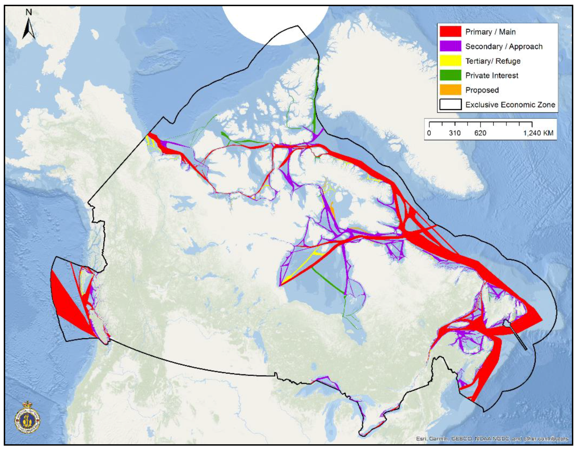
2.1. Marine Transportation Corridors
2.2. Water Depth
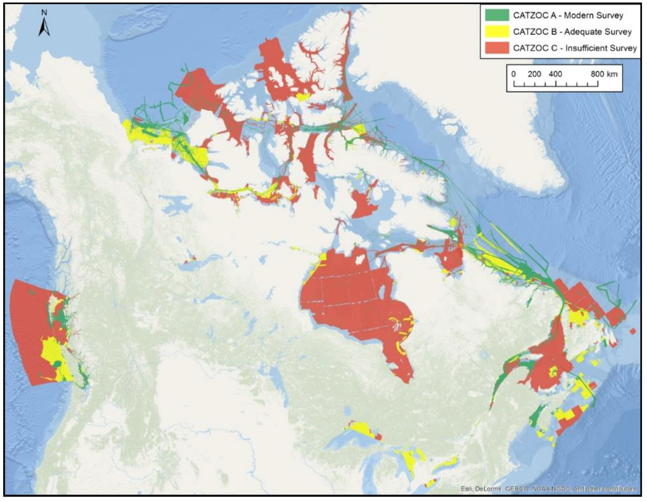
2.3. CHS Existing Surveys
2.4. Seafloor Complexity
2.5. Survey Requirements
2.6. Probability Risk Modelling
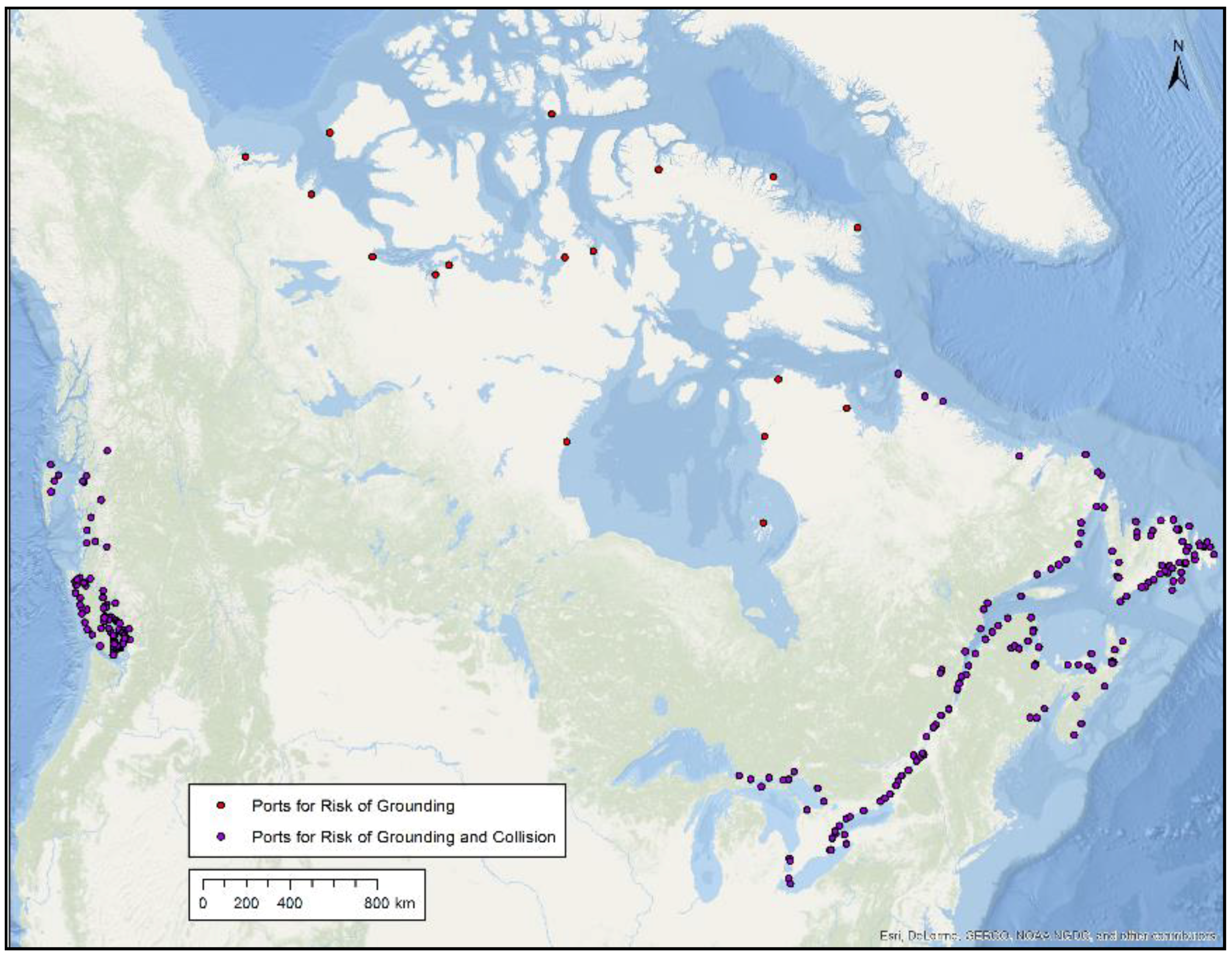
2.6.1. Risk of Grounding and Risk of Collision
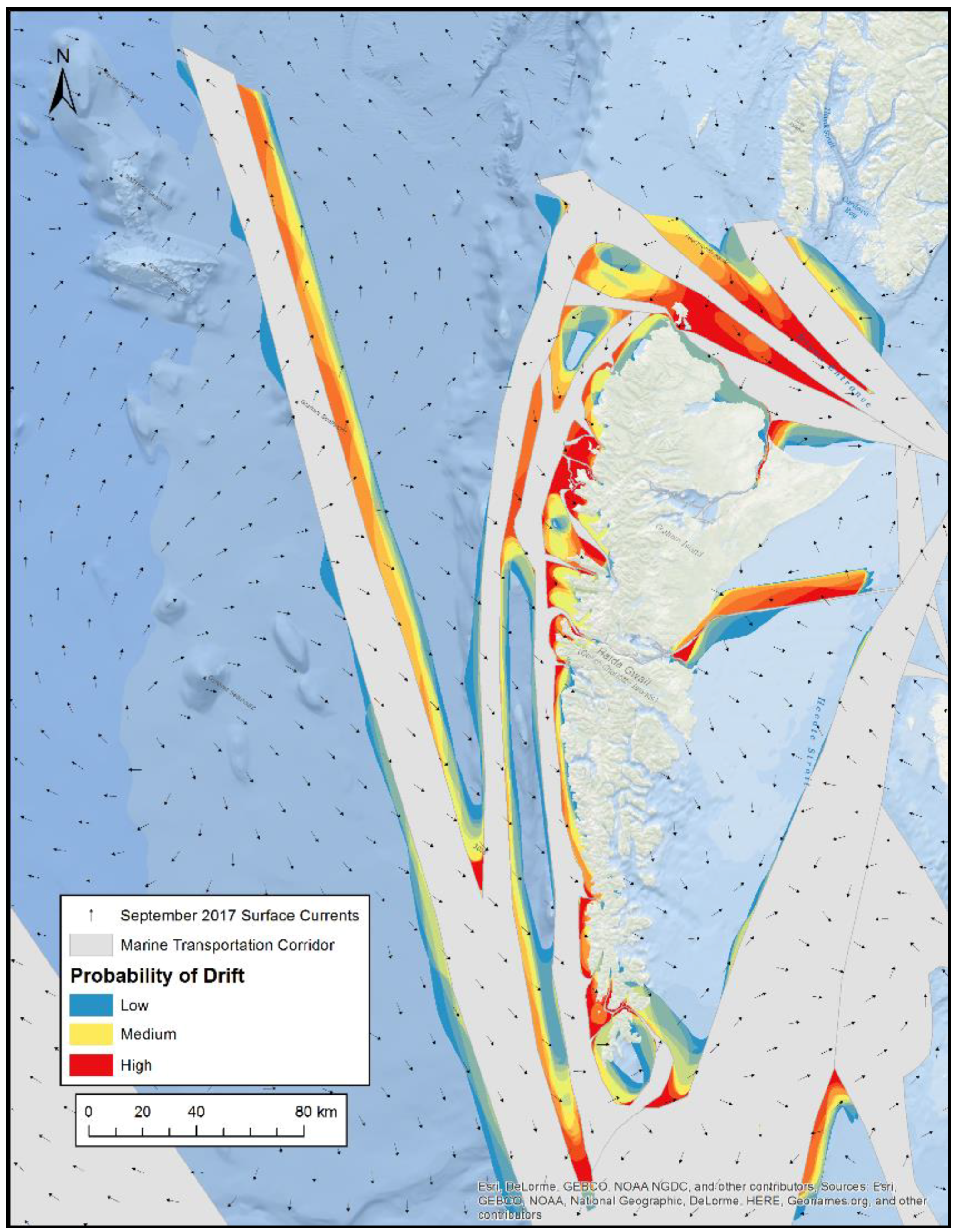
2.6.2. Drift Model Analysis
2.7. CHS Major Projects
3. Methodology
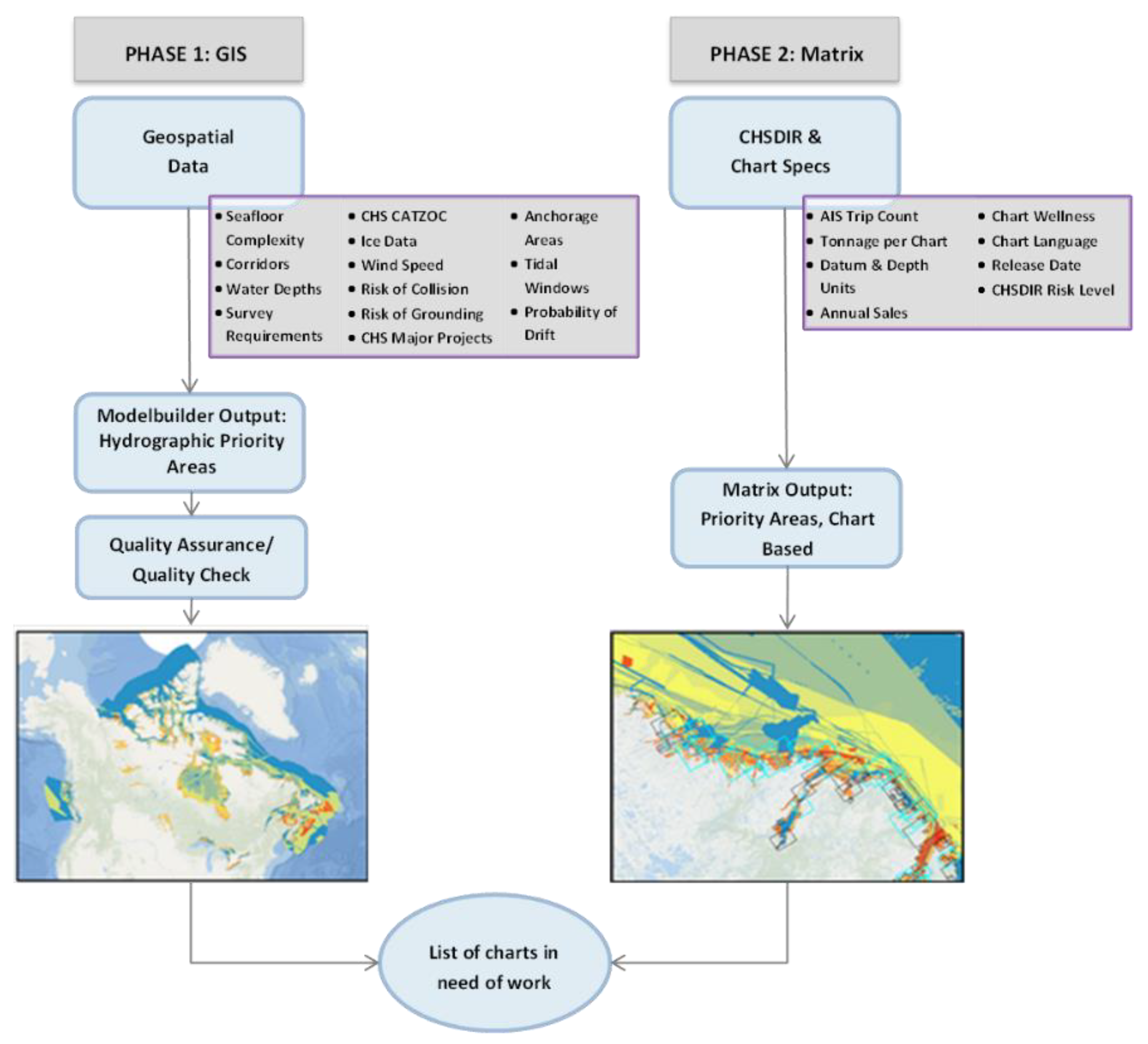
3.1. GIS Phase
- = weight assigned to factor
- = criterion score of factor ;
- = constraint .
3.2. Matrix Phase
4. Results and Discussion
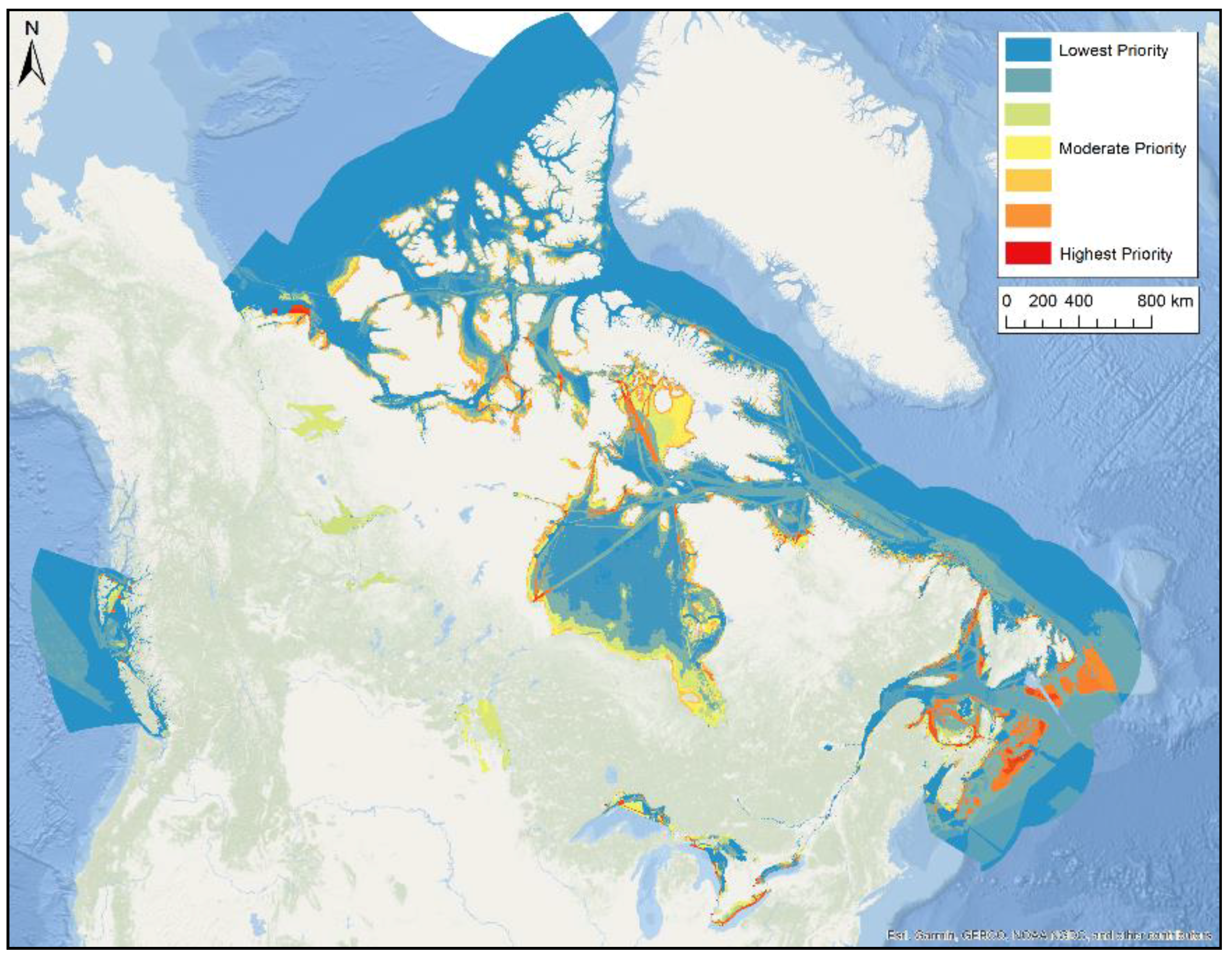
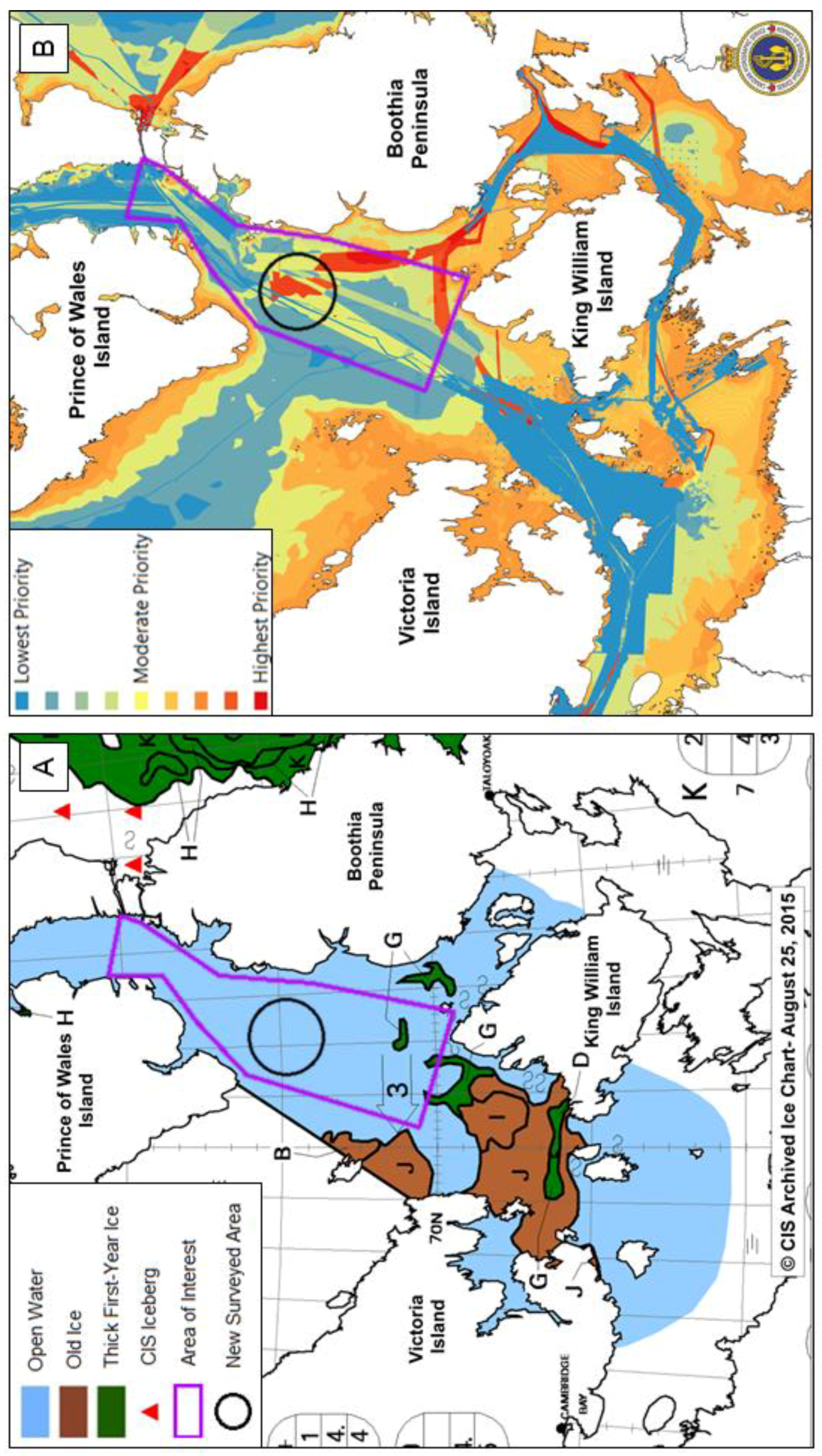
4.1. Results and Quality Control
4.2. Other Applications of CPPT
Contingency Plan
4.3. Future Work
5. Conclusions
Author Contributions
Funding
Acknowledgments
Conflicts of Interest
References
- DFO. The Role of the Canadian Government in the Oceans Sector; Oceans Directorate, Fisheries and Oceans Canada: Ottawa, ON, Canada, 2008; ISBN 978-1-100-11233-6. [Google Scholar]
- Fadaie, K. CHS Role in the Implementation of a World Class Tanker Safety System. In Proceedings of the US-Canada Hydrographic Commission, Harbor, MD, USA, 16 March 2015. [Google Scholar]
- Government of Canada. Harper Government Takes Action to Enhance Marine Safety in the Arctic. Archived News Release. 2015. Available online: https://www.canada.ca/en/news/archive/2015/07/harper-government-takes-action-enhance-marine-safety-arctic.html (accessed on 19 February 2018).
- Growing the Middle Class. 2016 Budget. 2016. Available online: http://www.budget.gc.ca/2016/docs/plan/budget2016-en.pdf (accessed on 19 February 2018).
- Riding, J.; Roberts, J.; Priovolos, G. Land Information New Zealand. In New Zealand Hydrographic Risk Assessment—National Overview Issue 1; Marico Marine NZ Limited: Wellington, New Zealand, 2016. [Google Scholar]
- National Oceanic and Atmospheric Administration. National Hydrographic Survey Priorities. U.S. Department of Commerce. Available online: https://nauticalcharts.noaa/gov/publications/national-Hydrographic-survey-prioirties.html (accessed on 19 February 2018).
- Transport Canada. Investments under the Oceans Protection Plan to protect Canada’s Arctic Coast and Water. Government of Canada, 2017. Available online: https://www.canada.ca/en/transport-canada/news/2017/08/investments_undertheoceansprotectionplantoprotectcanadasarcticco.html (accessed on 22 February 2018).
- Leyzack, A.; Chenier, R.; Hinds, S. Marine Corridors: A Methodology for Planning and Prioritizing Surveys, Products and Services. In Proceedings of the Canadian Hydrographic Conference, St. John’s, NL, Canada, 14–17 April 2014. [Google Scholar]
- Chenier, R.; Abado, L.; Sabourin, O.; Tardif, L. Northern marine transportation corridors: Creation and analysis of northern marine traffic routes in Canadian waters. Trans. GIS 2017, 21, 1085–1097. [Google Scholar] [CrossRef]
- International Hydrographic Organization. IHO Standards for Hydrographic Surveys. In International Hydrographic Organization, 5th ed.; Special Publication N°44; International Hydrographic Bureau: Monaco, Monaco, 2008. [Google Scholar]
- Goodchild, M. The State of GIS for Environmental Problem-Solving. In Environmental Modeling with GIS; Oxford University Press: New York, NY, USA, 1993; pp. 8–15. [Google Scholar]
- Malczewski, J. On the Use of Weighted Linear Combination Method in GIS: Common and Best Practice Approaches. Trans. GIS 2000, 4, 5–22. [Google Scholar] [CrossRef]
- Eastman, J.R.; Jin, W.; Kyem, P.A.K.; Toledano, J. Raster Procedures for Multi-Criteria/Multi-Objective Decisions. Photogramm. Eng. Remote Sens. 1995, 61, 539–547. [Google Scholar]
- ESRI GIS Dictionary. Available online: http://support.esri.com/en/knowledgebase/GISDictionary/term/quantile%20classification (accessed on 19 February 2018).
- Office of the Auditor General of Canada. Chapter 3 Marine Navigation in the Canadian Arctic. In 2014 Fall Report of the Commissioner of the Environment and Sustainable Development; Queen’s Printer of Canada: Ottawa, ON, USA, 2014. [Google Scholar]
- Dyer, E. Obama and Trudeau Pledge to Protect a Warming Arctic. CBC News, 2016. Available online: http://www.cbc.ca/news/politics/us-canada-arctic-protection-1.3486062 (accessed on 19 February 2018).
| Component | Information | Source |
|---|---|---|
| Marine Transportation Corridors | Primary/Main, Secondary/Approach, Tertiary/Refuge, Private Interest, and Proposed Corridors | CHS, Canadian Coast Guard (CCG), Transport Canada (TC) |
| Water Depth | 0–20 m, 21–50 m, 51–100 m, 101–200 m, 200+ m | CHS Paper charts/Electronic Navigational Charts (ENC), General Bathymetric Chart of the Oceans (GEBCO) |
| CHS Existing Surveys | Survey Category Zone of Confidence (CATZOC) A, CATZOC B (acceptable) | CHS—Survey data |
| Seafloor Complexity | Low, medium, high complexity | CHS Paper charts/ENC, GEBCO |
| Survey Requirements | Complex/Non-Complex seabed and CATZOC | CHS Paper charts/ENC, GEBCO |
| Anchorage Areas and Ports | Area, 1 km buffer zone | CHS Paper charts/ENC |
| Ice Concentration | Low, medium, high concentration; multi-year ice | Environment Canada (EC), Canadian Ice Service (CIS) |
| Wind Speed | 20 class average, low to high | Environment Canada (EC), CHS |
| Tidal Windows | Large tide areas | CHS |
| Risk of Grounding and Collision (Geographic Area) | Very low, low, medium, high, very high for both Risk of Grounding and Risk of Collision | CHS, CCG |
| CHS Drift Analysis | High, medium, and low values of probability of drift | CHS |
| CHS Major Projects | Major Projects within CHS will drive priority | CHS |
| Value | Survey Requirement |
|---|---|
| 0–20 m | CATZOC A |
| 21–50 m | CATZOC A |
| 51–100 m Complex Seafloor | CATZOC A |
| 51–100 m Non-Complex Seafloor | CATZOC B |
| 101–200 m Complex Seafloor | CATZOC B |
| 101–200 m Non-Complex Seafloor | CATZOC C |
| 200+ m | CATZOC C |
| Risk of Grounding Factors | Risk of Collision Factors |
|---|---|
| PIANC | Trip density |
| Minimum channel depth and width | Vessel maneuverability |
| Ship factors (speed, draft, width, length…) | 2 vs. 1 way traffic |
| Environmental (rides, wave height, wave exposure…) | Visibility |
| Depth ratio | Ice |
| Survey accuracy | Sedimentation |
| Component | Source |
|---|---|
| Priority Output (GIS based) | CHS |
| Risk of Grounding and Collision (as a reference) | CCG, CHS |
| Port Tonnage (Chart based) | CHS, TC |
| Trip Density (Chart based) | CHS, TC |
| Chart Release Date | CHS |
| Chart Datum | CHS |
| Chart Language | CHS |
| Chart Depth | CHS |
| Chart Projection | CHS |
| Chart Wellness (Chart based) | CHS |
| Chart Sales (Customer based; includes small craft harbors) | CHS |
© 2018 by the authors. Licensee MDPI, Basel, Switzerland. This article is an open access article distributed under the terms and conditions of the Creative Commons Attribution (CC BY) license (http://creativecommons.org/licenses/by/4.0/).
Share and Cite
Chénier, R.; Abado, L.; Martin, H. CHS Priority Planning Tool (CPPT)—A GIS Model for Defining Hydrographic Survey and Charting Priorities. ISPRS Int. J. Geo-Inf. 2018, 7, 240. https://doi.org/10.3390/ijgi7070240
Chénier R, Abado L, Martin H. CHS Priority Planning Tool (CPPT)—A GIS Model for Defining Hydrographic Survey and Charting Priorities. ISPRS International Journal of Geo-Information. 2018; 7(7):240. https://doi.org/10.3390/ijgi7070240
Chicago/Turabian StyleChénier, René, Loretta Abado, and Heather Martin. 2018. "CHS Priority Planning Tool (CPPT)—A GIS Model for Defining Hydrographic Survey and Charting Priorities" ISPRS International Journal of Geo-Information 7, no. 7: 240. https://doi.org/10.3390/ijgi7070240
APA StyleChénier, R., Abado, L., & Martin, H. (2018). CHS Priority Planning Tool (CPPT)—A GIS Model for Defining Hydrographic Survey and Charting Priorities. ISPRS International Journal of Geo-Information, 7(7), 240. https://doi.org/10.3390/ijgi7070240


