Geographic Information Retrieval Method for Geography Mark-Up Language Data


Abstract
1. Introduction
2. GML Document Data and Retrieval Mode Construction
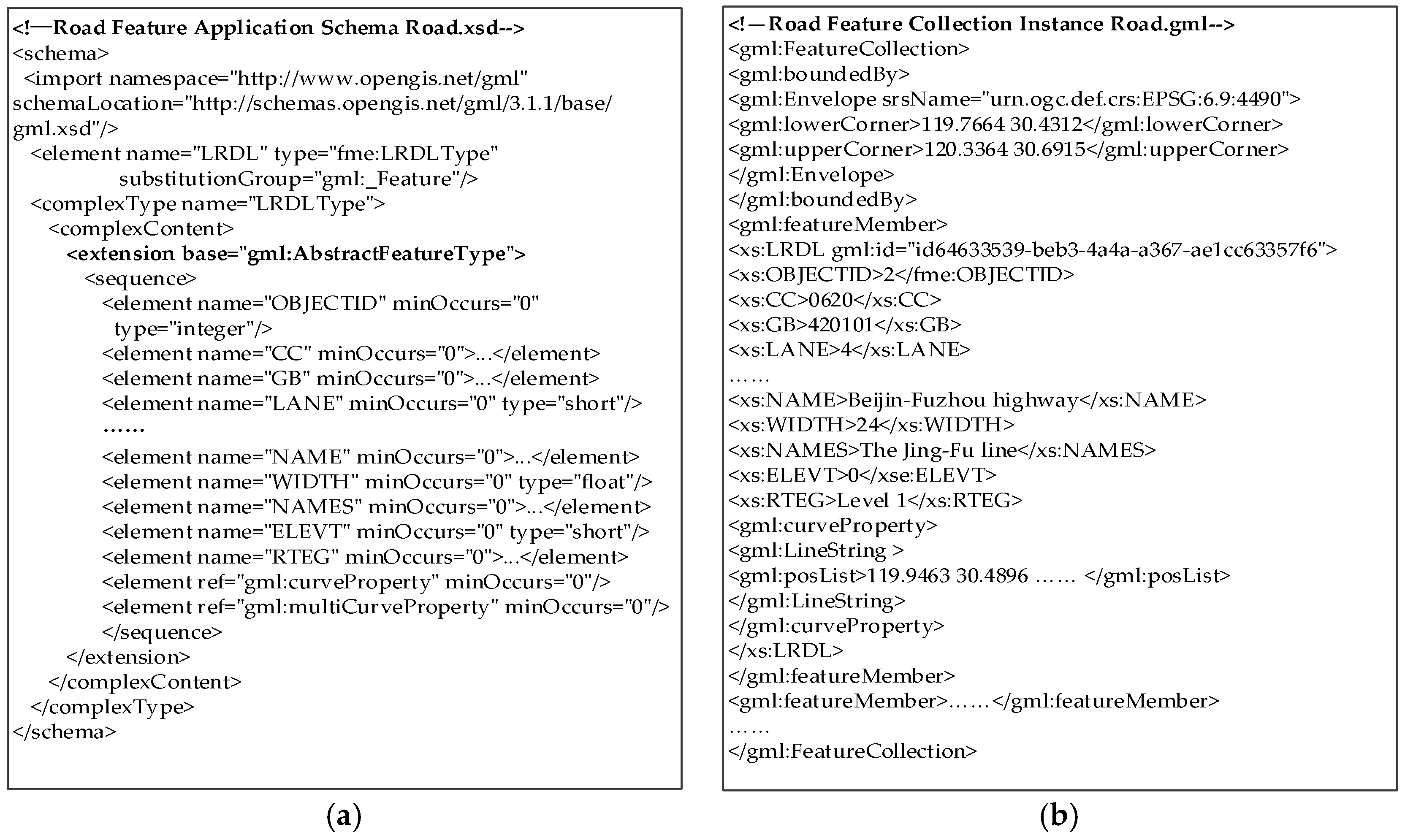
2.1. Analysis of GML Document Data
2.2. GML Data Feature and Retrieval Mode Construction
2.3. Extraction of GML Information Retrieval Granularity and Definition
3. GML_GIR Retrieval Model
3.1. Attribute Relevance Calculation
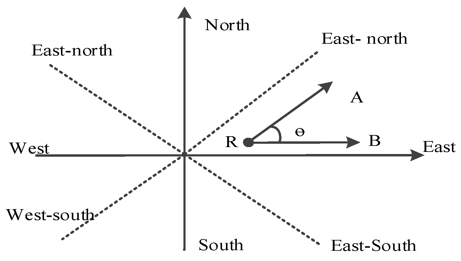
3.2. Spatial Relation Relevance Calculation
3.3. Structure Relevance Calculation
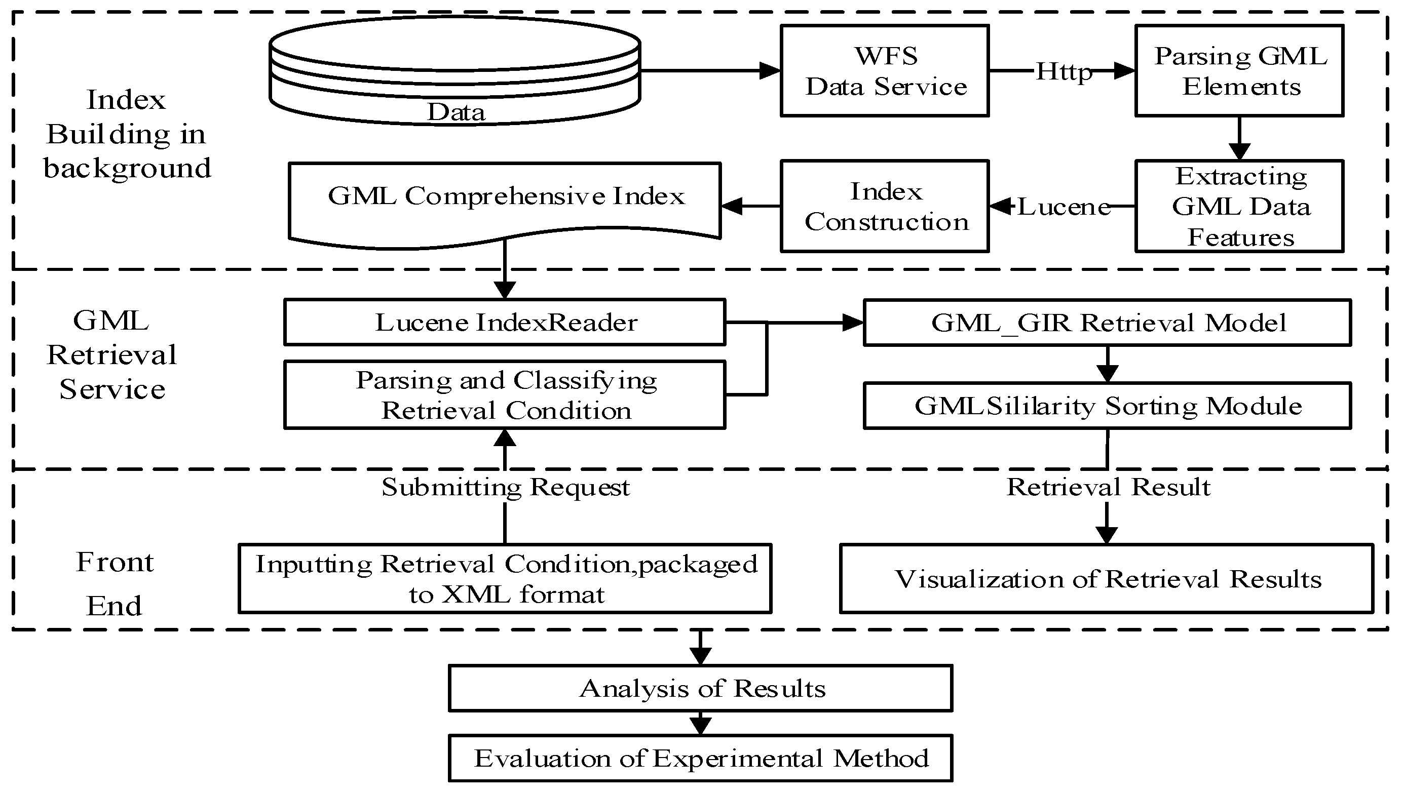
4. Retrieval Implementation Based on GML_GIR
4.1. Process for GML Data Retrieval
4.2. Index Construction of GML Document Data
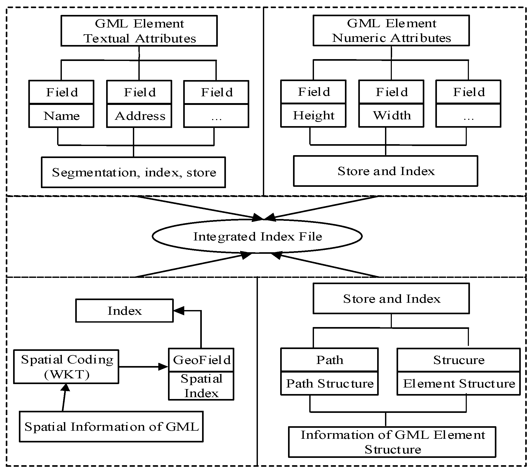
4.2.1. Index Model for GML
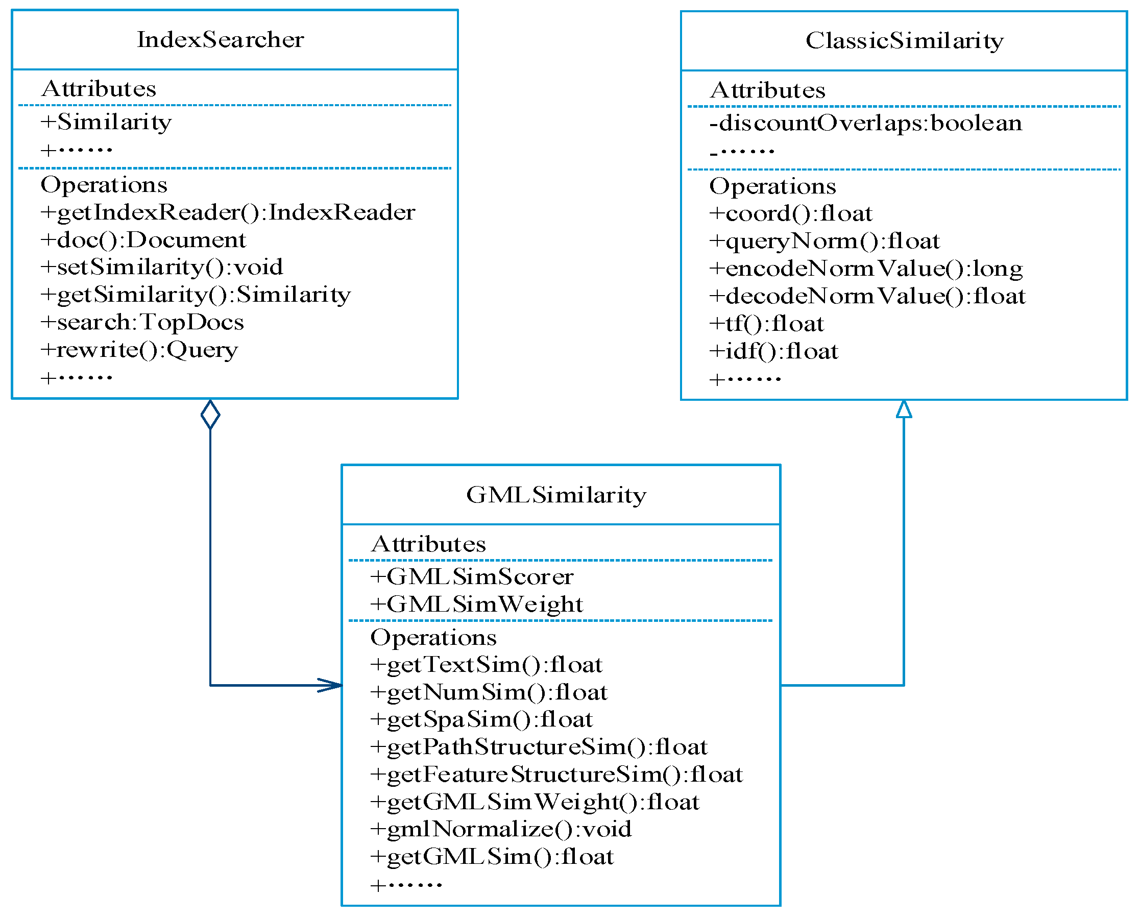
4.2.2. Implementation for GML Index
4.3. Correlation Ranking Model of Retrieval Results
5. Experiments and Results
5.1. Experimental Environment and Data Source
5.2. Experimental Procedure
- Testing attribute retrieval (R1); only text or numbers were included.
- A testing retrieval combination of simple spatial relationships and attributes (R2-R4).
- A testing retrieval combination of kinds of spatial relationship factors and attributes (R5).
- Testing retrieval structural features (R6).
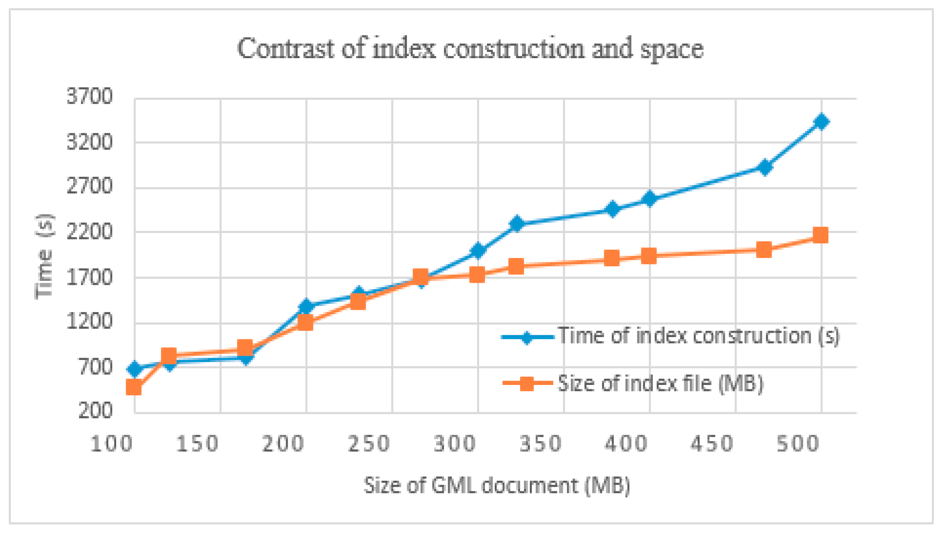
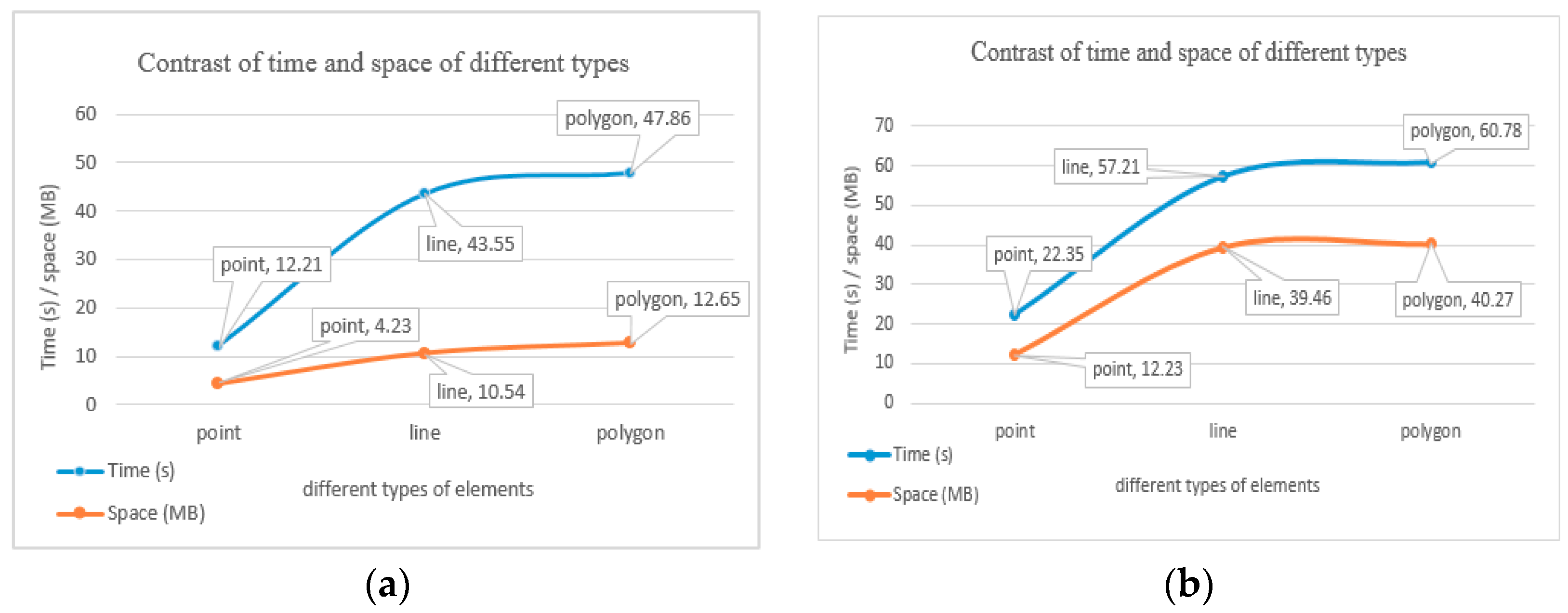
5.3. Efficiency of Index Construction
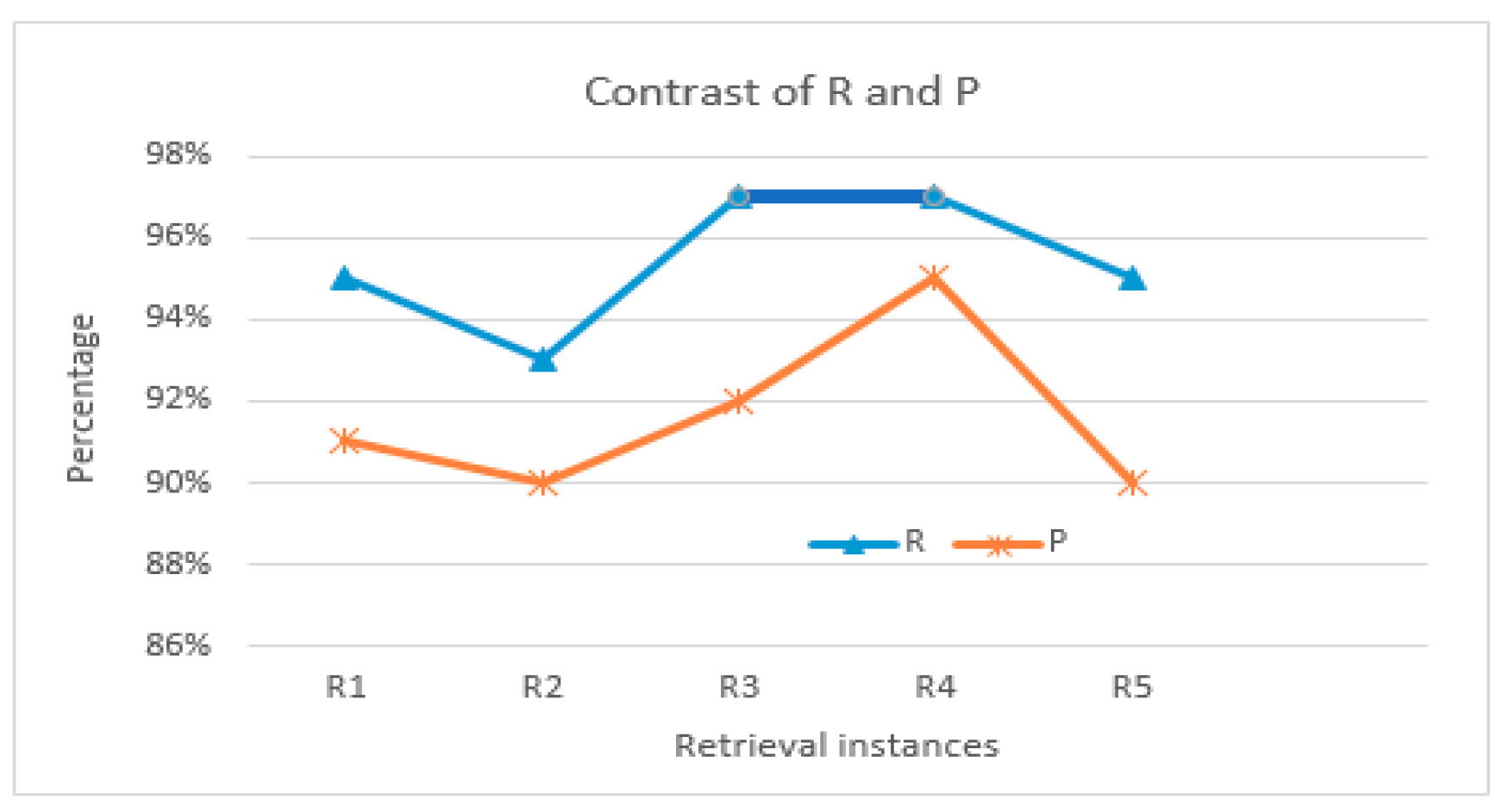
5.4. Retrieval Effectiveness
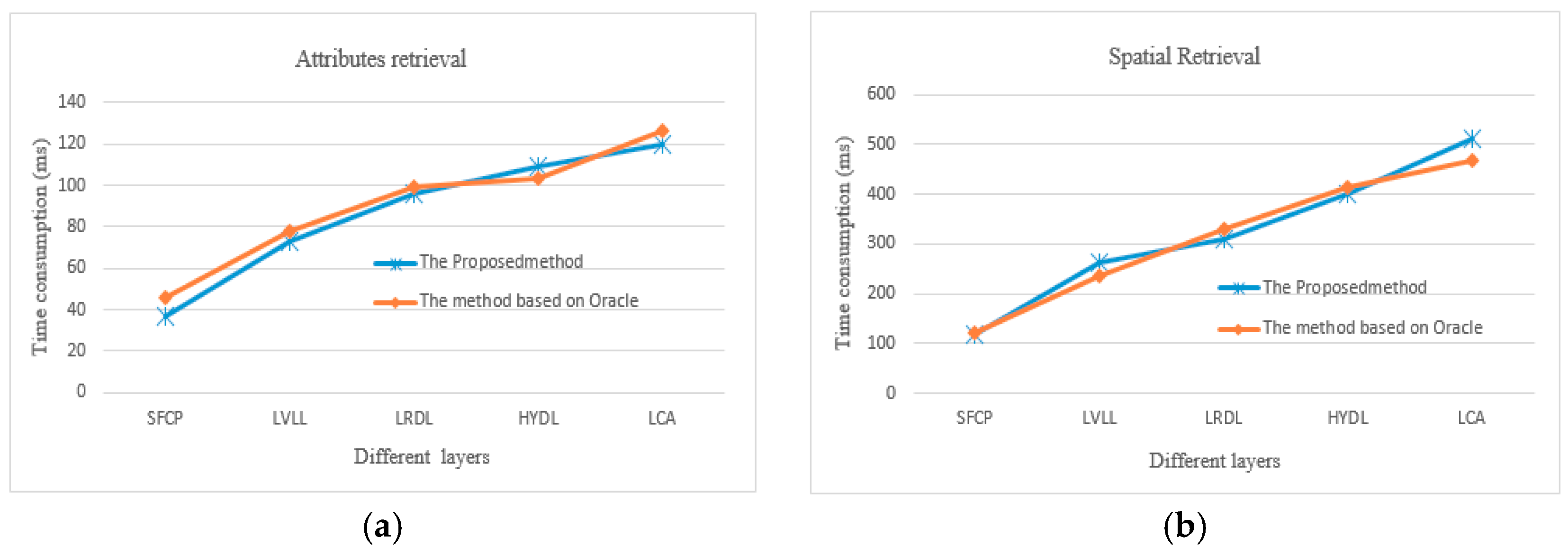
5.5. Retrieval Efficiency
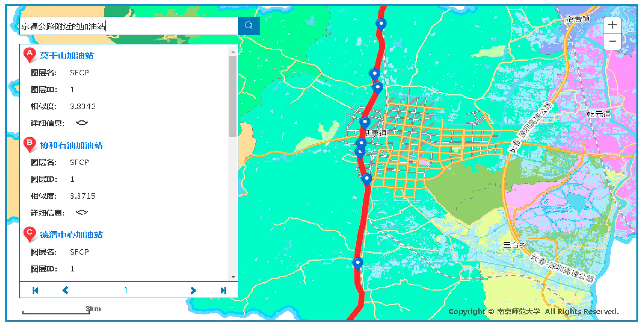
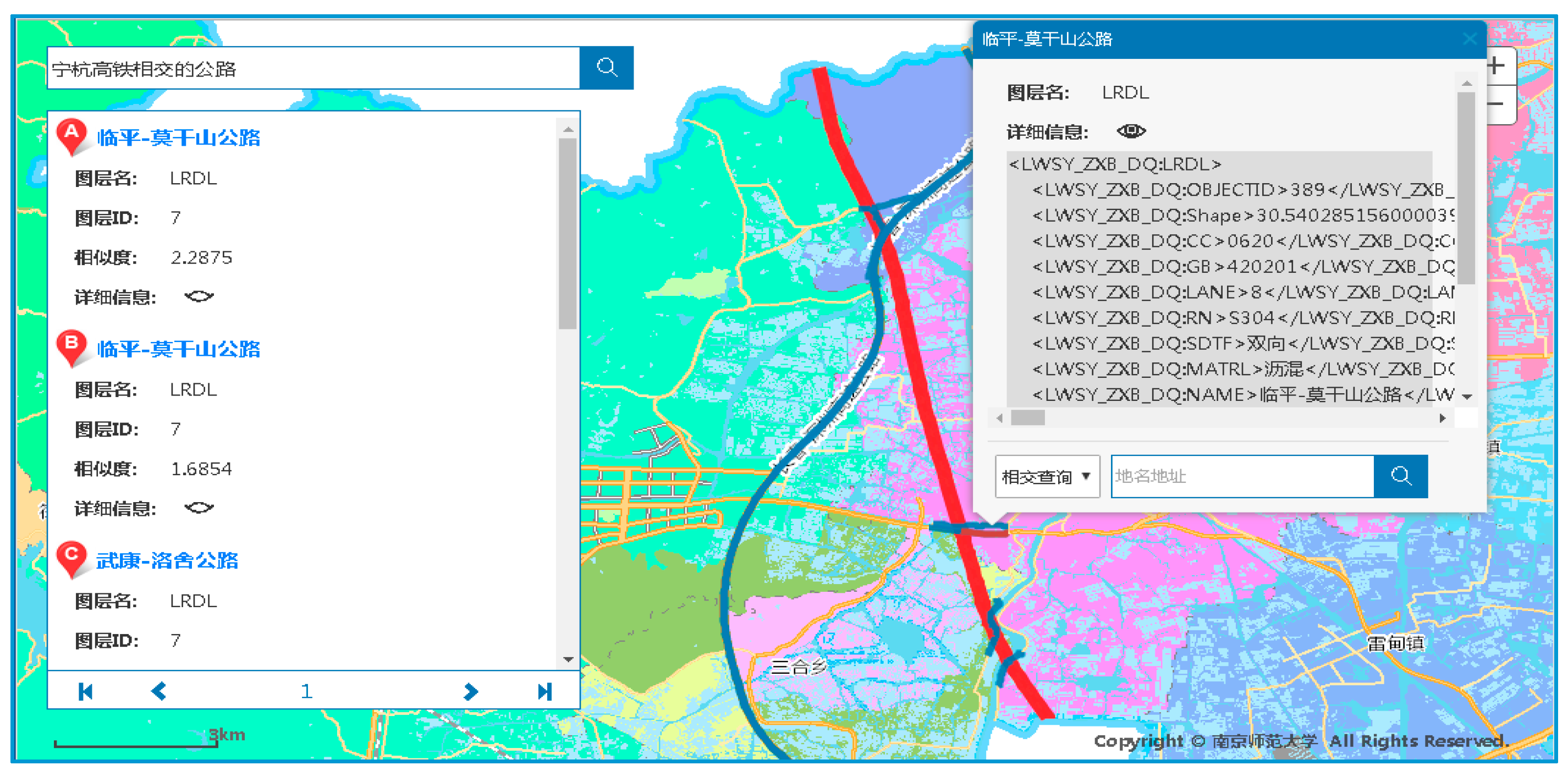
5.6. Retrieval Running Examples
6. Conclusions
Acknowledgments
Author Contributions
Conflicts of Interest
References
- Zhu, Q.; Li, Y.; Xiong, Q.; Zlatanova, S.; Ding, Y.; Zhang, Y.; Zhou, Y. Indoor multi-dimensional location gml and its application for ubiquitous indoor location services. ISPRS Int. J. Geo-Inf. 2016, 5, 220. [Google Scholar] [CrossRef]
- Brunk, B.K.; Porosnicu, E. Aeronautical Information Exchange Model (AIXM) GIS interoperability through GML. In Proceedings of the Twenty-Fifth Annual ESRI, International User Conference, San Diego, CA, USA, 25–29 July 2008. [Google Scholar]
- Gröger, G.; Plümer, L. Citygml-interoperable semantic 3d city models. ISPRS J. Photogramm. Remote Sens. 2012, 71, 12–33. [Google Scholar] [CrossRef]
- Papadimitriou, F. The Algorithmic Complexity of Landscapes. Landsc. Res. 2012, 37, 591–611. [Google Scholar] [CrossRef]
- Selvaganesan, S.; Haw, S.C.; Soon, L.K. Effective XML keyword search using dual indexing technique. Inf. Technol. J. 2014, 13, 643–651. [Google Scholar] [CrossRef][Green Version]
- Ren, J.H.; Zhou, J.; Meng, X.F.; Wei, K. Results ranking approach of XML keyword search based on keyword’s structural relationships. Comput. Sci. 2013, 6, 178–182. [Google Scholar]
- Li, J.; Xiong, H.L. XML keywords retrieval by integrating semantics of document and user inquiries. J. Comput. Appl. 2010, 11, 2945–2948. [Google Scholar] [CrossRef]
- Li, X.; Li, Z.H.; Zhang, L.J.; Chen, Q.; Li, N. MXDR: Distributed information retrieval for multi-XML document based on keywords. Comput. Sci. 2011, 10, 152–156. [Google Scholar]
- Zhou, X.P.; Shi, Y.M.; Zhang, J. Parallel top-k keyword search algorithm in probabilistic XML documents. Comput. Sci. 2013, 3, 232–237. [Google Scholar]
- Chan, C.Y.; Felber, P.; Garofalakis, M. Efficient filtering of XML documents with XPath expressions. VLDB J. Int. J. Very Large Data Bases 2002, 11, 354–379. [Google Scholar] [CrossRef]
- Lian, X.; Lin, W.J.; Zhang, F.W. Similarity evaluation between XML documents based on bidirectional path constraint model. J. Comput. Res. Dev. 2010, 47, 60–65. [Google Scholar]
- Wang, L.; Cheung, D.W.; Mamoulis, N. An efficient and scalable algorithm for clustering XML documents by structure. IEEE Trans. Knowl. Data Eng. 2004, 16, 82–96. [Google Scholar] [CrossRef]
- Liu, X.P.; Wan, C.X.; Liu, D.X. Effective XML vague content and structure retrieval and scoring. J. Comput. Res. Dev. 2010, 6, 1070–1078. [Google Scholar]
- Corcoles, J.E.; Gonzalez, P. A specification of a spatial query language over GML. In Proceedings of the 9th ACM International Symposium on Advances in Geographic Information Systems, Allanta, GA, USA, 9–10 November 2001; pp. 112–117. [Google Scholar]
- Boucelma, O.; Colonna, FM. Gquery: A query language for GML. In Proceedings of the 24th Urban Data Management Symposium, Chioggia Venice, Italy, 27–29 October 2004; pp. 27–39. [Google Scholar]
- Almendros-Jiménez, J.M.; Becerra-Terón, A.; García-García, F. Xpath for querying GML-based representation of urban maps. In Computational Science and Its Applications—ICCSA 2011, Proceedings of the 2011 International Conference on Computational Science and Its Applications, Santander, Spain, 20–23 June 2011; Lecture Notes in Computers Science; Springer: Berlin, Germany, 2011; Volume 6782, pp. 177–191. [Google Scholar]
- Savary, L.; Gardarin, G.; Zeitouni, K. GeoCache: A cache for GML geographical data. Int. J. Data Warehous. Min. 2007, 3, 67–88. [Google Scholar] [CrossRef]
- Lan, X.J.; Lv, G.N.; Liu, D. Xquery based GML query language. Sci. Surv. Mapp. 2005, 6, 100–103. [Google Scholar]
- Guan, J.H.; Zhu, F.B.; Zhou, J.G.; Niu, L.P. GQL: Extending XQuery to query GML documents. Geo-Spat. Inf. Sci. 2006, 2, 118–126. [Google Scholar]
- Tong, X.H.; Xu, G.S.; Gong, J.Y. Modeling spatial features based on geography markup language in GIS. Geomat. Inf. Sci. Wuhan Univ. 2005, 30, 209–213. [Google Scholar]
- Jones, C.B.; Purves, R.S. Geographic Information Retrieval. Int. J. Geogr. Inf. Sci. 2008, 22, 219–228. [Google Scholar] [CrossRef]
- Cai, G. GeoVSM: An integrated retrieval model for geographic information. In Proceedings of the International Conference on Geographic Information Science, Boulder, CO, USA, 25–28 September 2002; Springer: London, UK, 2002; pp. 65–79. [Google Scholar]
- Buscaldi, D.; Rosso, P. Explicit query diversification for geographical information retrieval. In Proceedings of the 33rd European Conference on Information Retrieval, ECIR 2011, Dublin, Ireland, 18–21 April 2011; pp. 73–80. [Google Scholar]
- Papadimitriou, F. Artificial intelligence in modelling the complexity of mediterranean landscape transformations. Comput. Electron. Agric. 2012, 81, 87–96. [Google Scholar] [CrossRef]
- Ren, K.J.; Zhang, S.W.; Lin, H.F. A document’s placenames-aware document ranking for GIR. Acta Sci. Nat. Univ. Pekin. 2013, 49, 219–226. [Google Scholar]
- Salton, G.; Wong, A.; Yang, C.S. A vector space model for automatic indexing. Commun. ACM 1974, 18, 613–620. [Google Scholar] [CrossRef]
- Cardoso, N.; Cruz, D.; Chaves, M.; Silva, M.J. Using geographic signatures as query and document scopes in geographic IR. In Advances in Multilingual and Multimodal Information Retrieval; Springer: Berlin, Germany, 2008; Volume 5152, pp. 802–810. [Google Scholar]
- Bruns, H.T.; Egenhofer, M.J. Similarity of spatial scenes. In Proceedings of the Seventh International Symposium on Spatial Data Handling, Delft, The Netherlands, 12–16 August 1996; pp. 173–184. [Google Scholar]
- Goyal, R.; Egenhofer, M.J. Consistent queries over cardinal directions across different levels of detail. In Proceeding of the 11th International Workshop on Database and Expert Systems Applications, London, UK, 4–8 September 2000; pp. 876–880. [Google Scholar]
- Liao, H.W.; Yang, Y.; Jia, Z. An improved web structure similarity based on matching algorithm of tree paths. J. Jilin Univ. 2012, 50, 1199–1203. [Google Scholar]


| Retrieval Features | Classification of Retrieval Modes | Examples |
|---|---|---|
| Attribute features | Text attributes | Name: supermarkets |
| Number attributes | Length: the road of less than 3 km | |
| Spatial features + others | Topology + attributes | Name: gas stations Spatial constraint: in Wukang town |
| Topology + measurement + attributes | Name: restaurants Spatial constraint: a park east 100 m | |
| Topology + directions + attributes | Name: highways Width: more than 20 m Spatial constraint: Ning-Hang high speed rail east and intersecting with it | |
| Topology + measurement + composite attributes | Name: hotels Star level: above 3-star Spatial constraint: the park east and within 2 km | |
| Structure features | Element structures | Searching linear features that include NAME, WIDTH attributes: <field>NAME,string</field> <field>WIDTH,integer</field> |
| Path structures | Searching POI elements: /ROOT/FeatureCollection/POI/FeatureMember/* |
| Target Object Retrieval Condition | Disjoints | Touches | Intersects | Equals | Contains | Within |
|---|---|---|---|---|---|---|
| Disjoints | 1 | 0.5 | 0.5 | 0.5 | 0 | 0 |
| Touches | 1 | 0.5 | 0.25 | 0.25 | 0.25 | |
| Intersects | 1 | 0.5 | 0.25 | 0.25 | ||
| Equals | 1 | 0.5 | 0.5 | |||
| Contains | 1 | 0 | ||||
| Within | 1 |
| Methods | Description |
|---|---|
| getTextSim() | Obtaining correlation of text, based on TF-IDF |
| getNumSim() | Obtaining correlation of numbers |
| getSpaSim() | Obtaining correlation of spatial relationships |
| getPathStructureSim() | Obtaining correlation of path structures |
| getFeatureStructureSim() | Obtaining correlation of element structures |
| getGMLSimWeight() | Overriding weight() to set weights of similarity |
| gmlNormalize() | Overriding normalize() to normalize correlation of geographical entities |
| getGMLSim() | Calculating scores of correlation of geographical entities in final retrieval results |
| Layer Label | Layer Name | Geometry Type | Number of Elements | Size of GML Document (KB) |
|---|---|---|---|---|
| SFCP | Construction (Point) | Point | 2340 | 1070.5 |
| SFCL | Construction (Line) | Line | 568 | 548 |
| SFCA | Construction (Polygon) | Polygon | 12 | 1.37 |
| LVLL | Country Road | Line | 959 | 1597.44 |
| LCTL | Urban Road | Line | 364 | 254 |
| LRDL | Highway | Line | 1174 | 1556.48 |
| LRRL | Railway | Line | 7 | 26.1 |
| HYDL | Water (Line) | Line | 3471 | 4700.16 |
| HYDA | Water (Polygon) | Polygon | 15,902 | 62531 |
| BUCP | Comprehensive Unit (Point) | Point | 323 | 156 |
| BOUP7 | Administrative Village | Point | 181 | 76.8 |
| BUCA | Comprehensive Unit (Polygon) | Polygon | 20 | 2.46 |
| BOUA6 | County District | Polygon | 11 | 1146.88 |
| LCA | Land Cover Classification Data | Polygon | 112,334 | 525,312 |
| Numbers | Examples | Retrieval Type |
|---|---|---|
| R1 | Scenic area above 4-A level | Text and numeric attributes |
| R2 | Hospitals in Wukang | Topologic relation and attributes |
| R3 | Restaurants within 500 km from Deqing People’s Hospital | Metric relation and attribute |
| R4 | Gas Station in southeast of Beijing-Fuzhou Highway | Position relation and attributes |
| R5 | Gas Station 500 m in southeast of Beijing-Fuzhou Highway | Metric relation, position relation and attributes |
| R6 | (All required type of elements in layer SFCP) | Structural relation |
| Retrieval Instances | The Proposed Method | The Method Based on Oracle | ||
|---|---|---|---|---|
| R | P | R | P | |
| R1 | 95% | 90% | 90% | 91% |
| R2 | 92% | 90% | 93% | 90% |
| R3 | 97% | 92% | 83% | 93% |
| R4 | 97% | 95% | 92% | 90% |
| R5 | 95% | 90% | 89% | 83% |
| R6 | 100% | 92% | 100% | 93% |
© 2018 by the authors. Licensee MDPI, Basel, Switzerland. This article is an open access article distributed under the terms and conditions of the Creative Commons Attribution (CC BY) license (http://creativecommons.org/licenses/by/4.0/).
Share and Cite
Fang, C.; Zhang, S. Geographic Information Retrieval Method for Geography Mark-Up Language Data. ISPRS Int. J. Geo-Inf. 2018, 7, 89. https://doi.org/10.3390/ijgi7030089
Fang C, Zhang S. Geographic Information Retrieval Method for Geography Mark-Up Language Data. ISPRS International Journal of Geo-Information. 2018; 7(3):89. https://doi.org/10.3390/ijgi7030089
Chicago/Turabian StyleFang, Caili, and Shuliang Zhang. 2018. "Geographic Information Retrieval Method for Geography Mark-Up Language Data" ISPRS International Journal of Geo-Information 7, no. 3: 89. https://doi.org/10.3390/ijgi7030089
APA StyleFang, C., & Zhang, S. (2018). Geographic Information Retrieval Method for Geography Mark-Up Language Data. ISPRS International Journal of Geo-Information, 7(3), 89. https://doi.org/10.3390/ijgi7030089