
Application of GPS Trajectory Data for Investigating the Interaction between Human Activity and Landscape Pattern: A Case Study of the Lijiang River Basin, China


Abstract
:1. Introduction
2. Materials and Methods
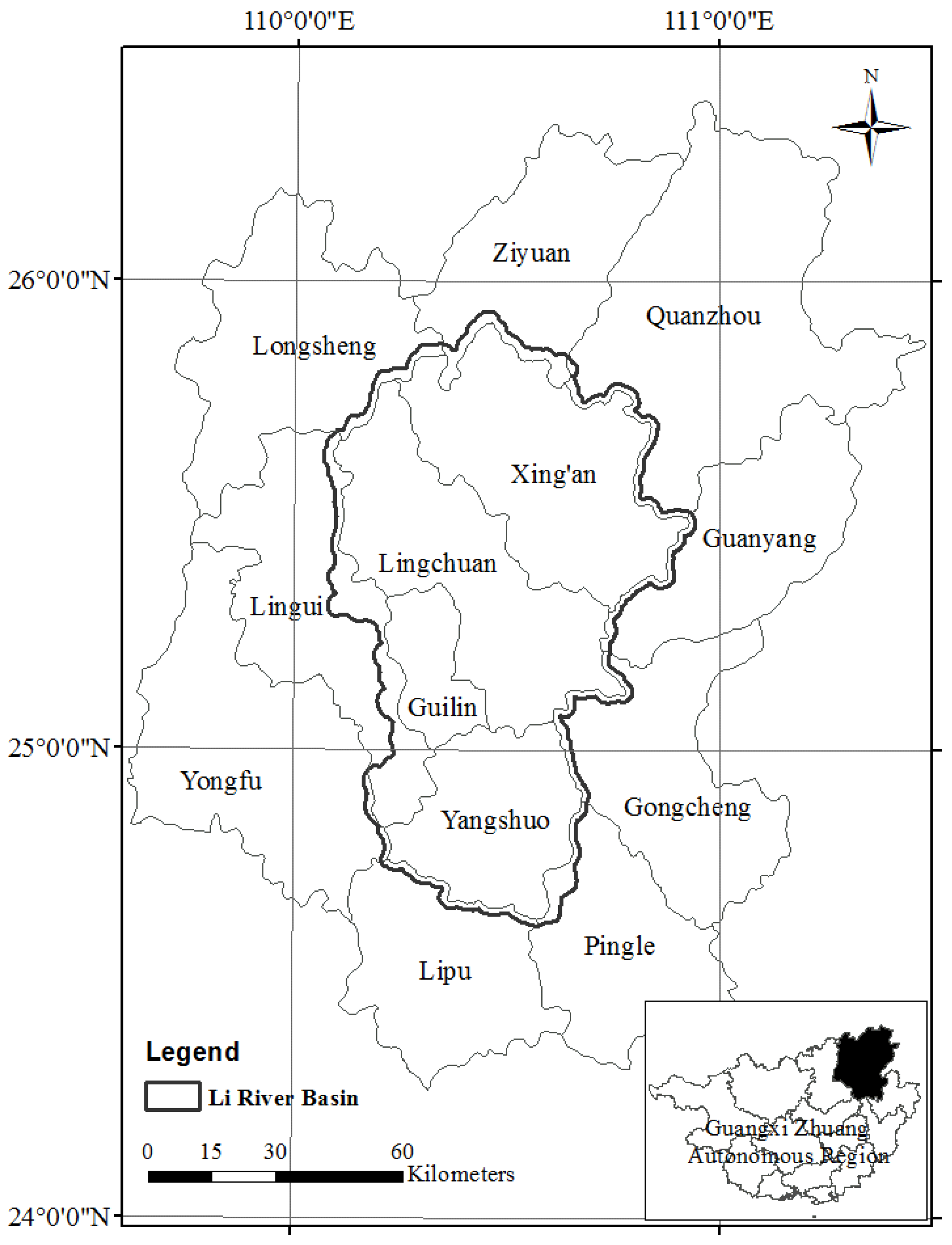
2.1. Study Area
2.2. Data Acquisition
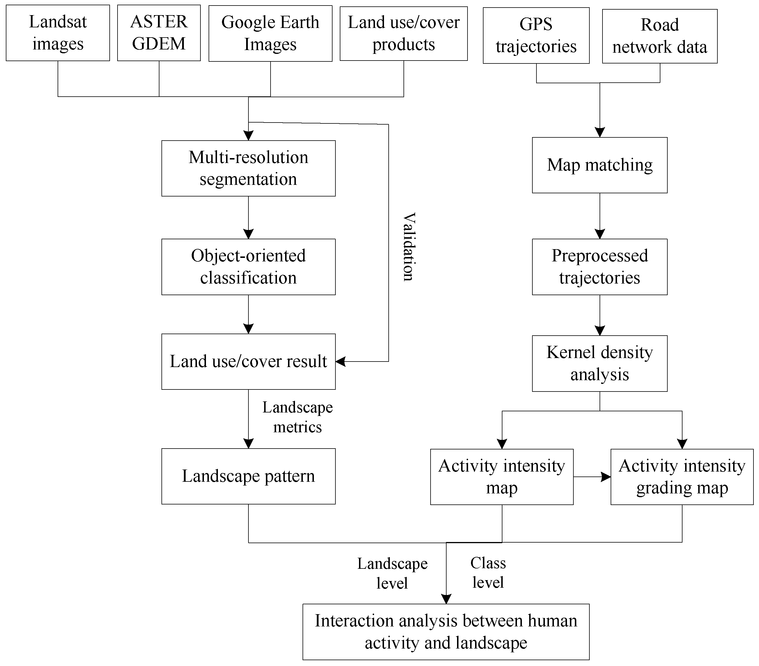
2.3. Workflow
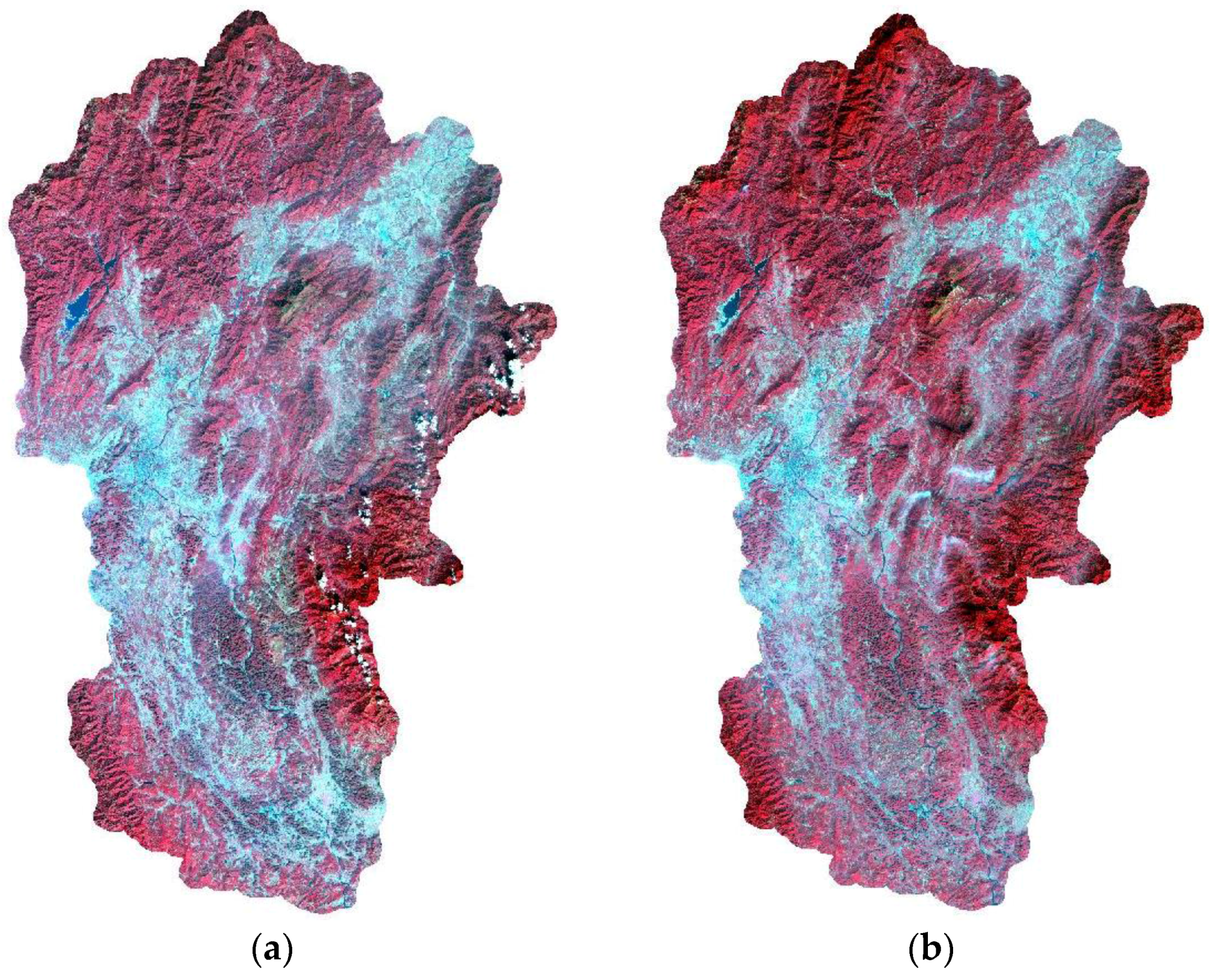
2.4. Landsat Image Classification
2.5. Landscape Pattern Analysis
2.6. Human Activity Analysis
2.7. Interaction Analysis between Human Activity and Landscape Pattern
3. Results and Discussion
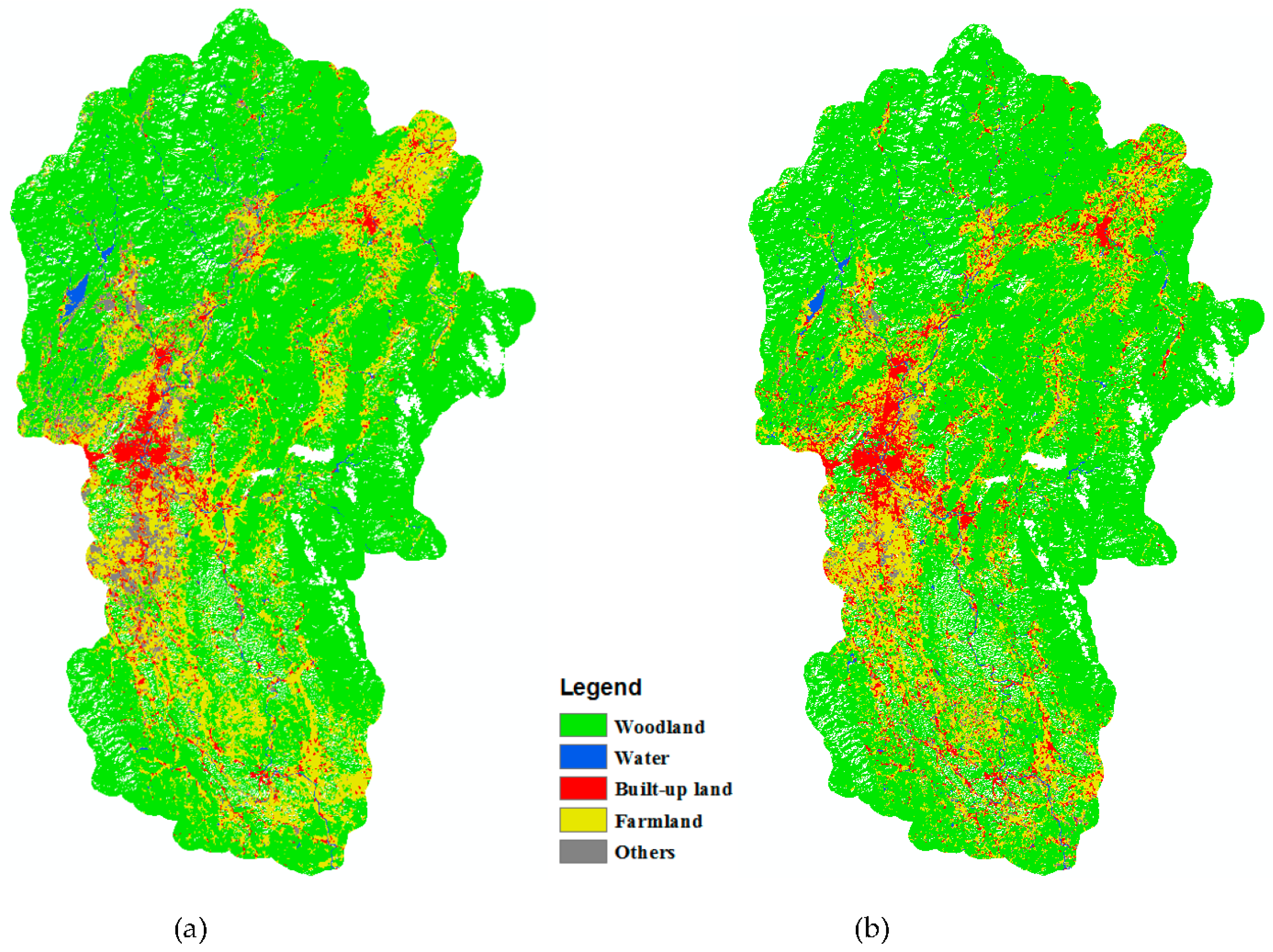
3.1. Landscape Pattern in the Lijiang River Basin
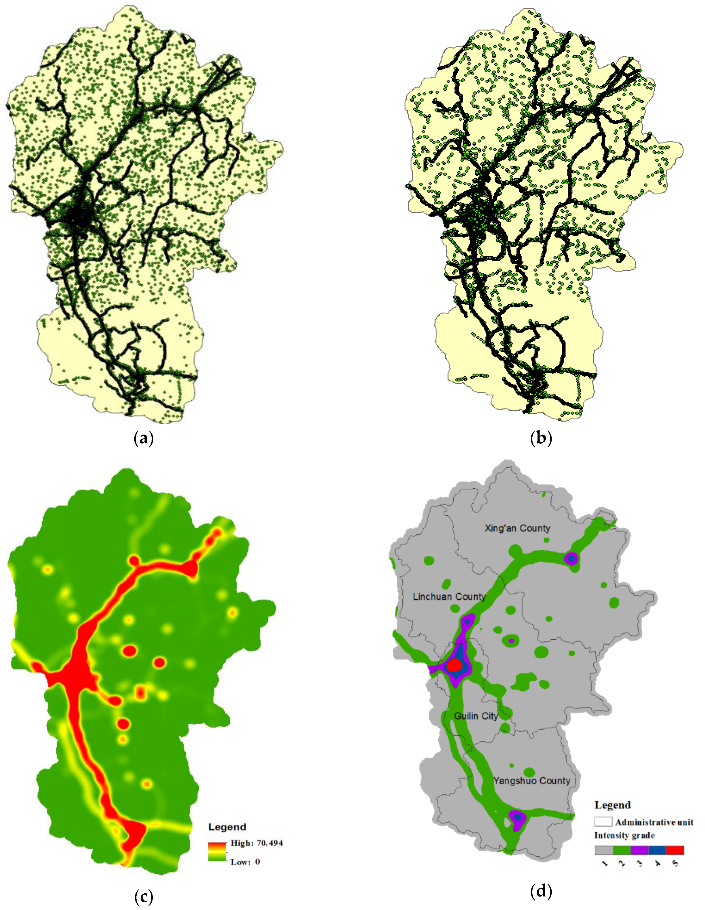
3.2. Human Activity Distribution
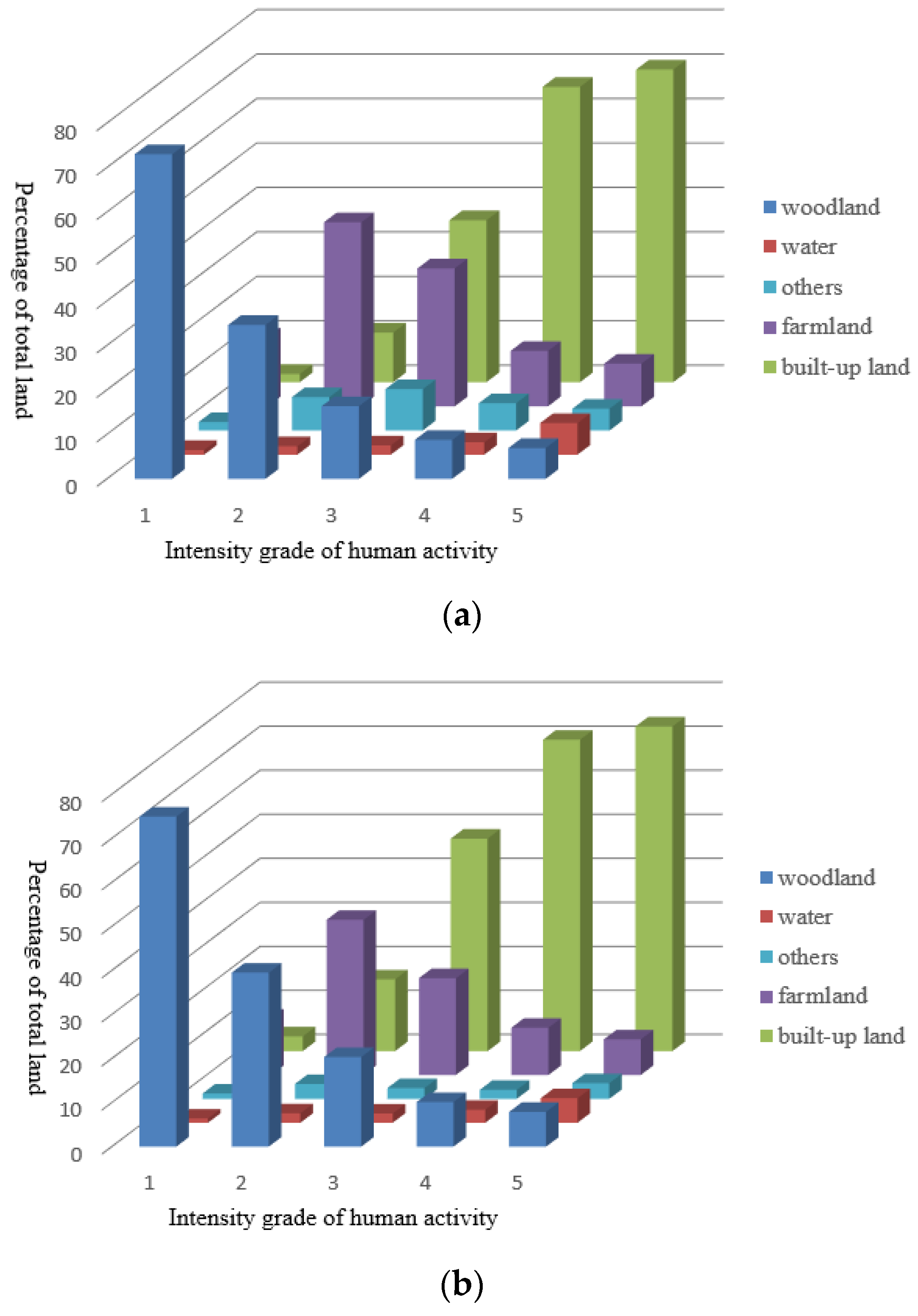
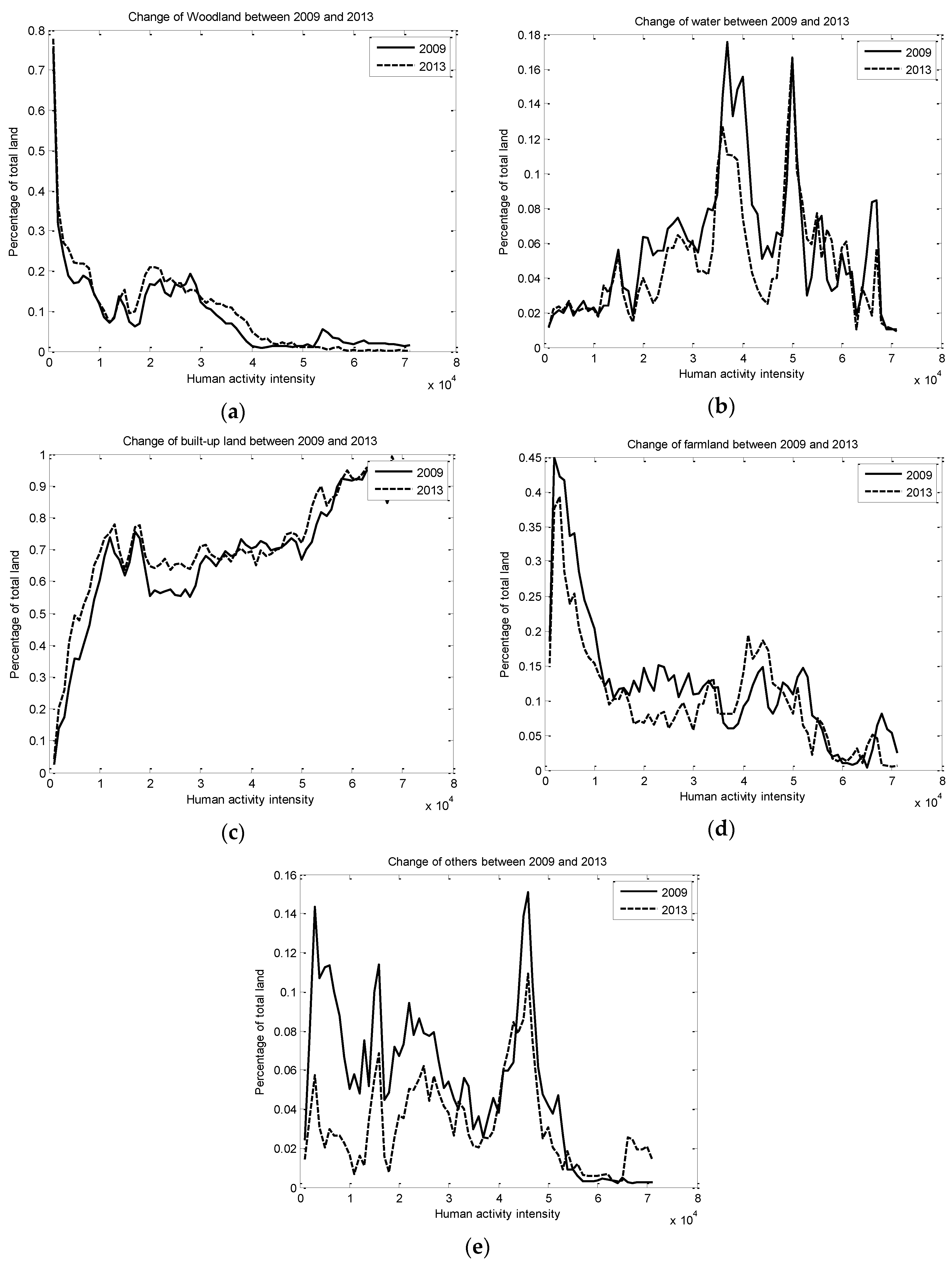
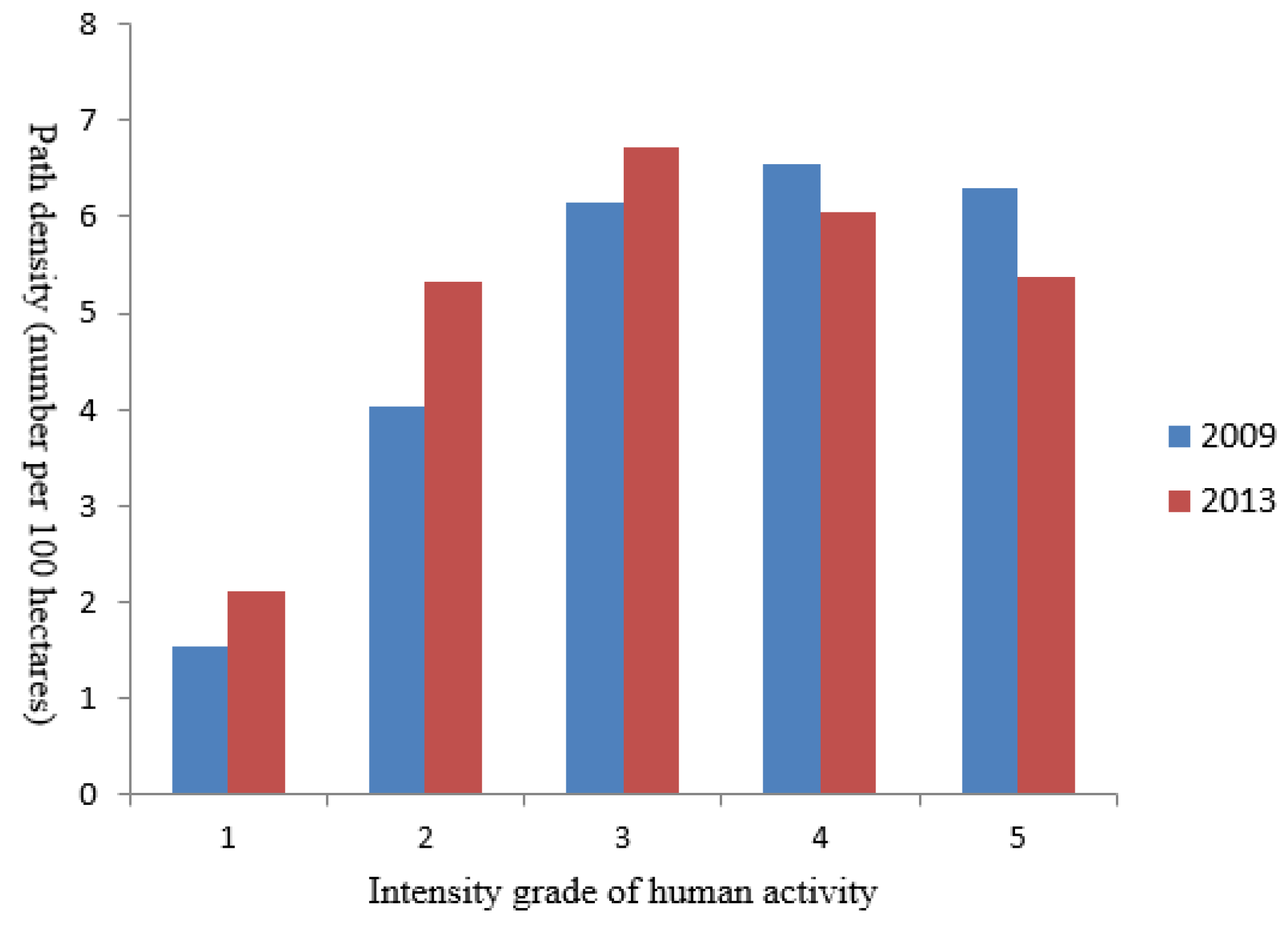
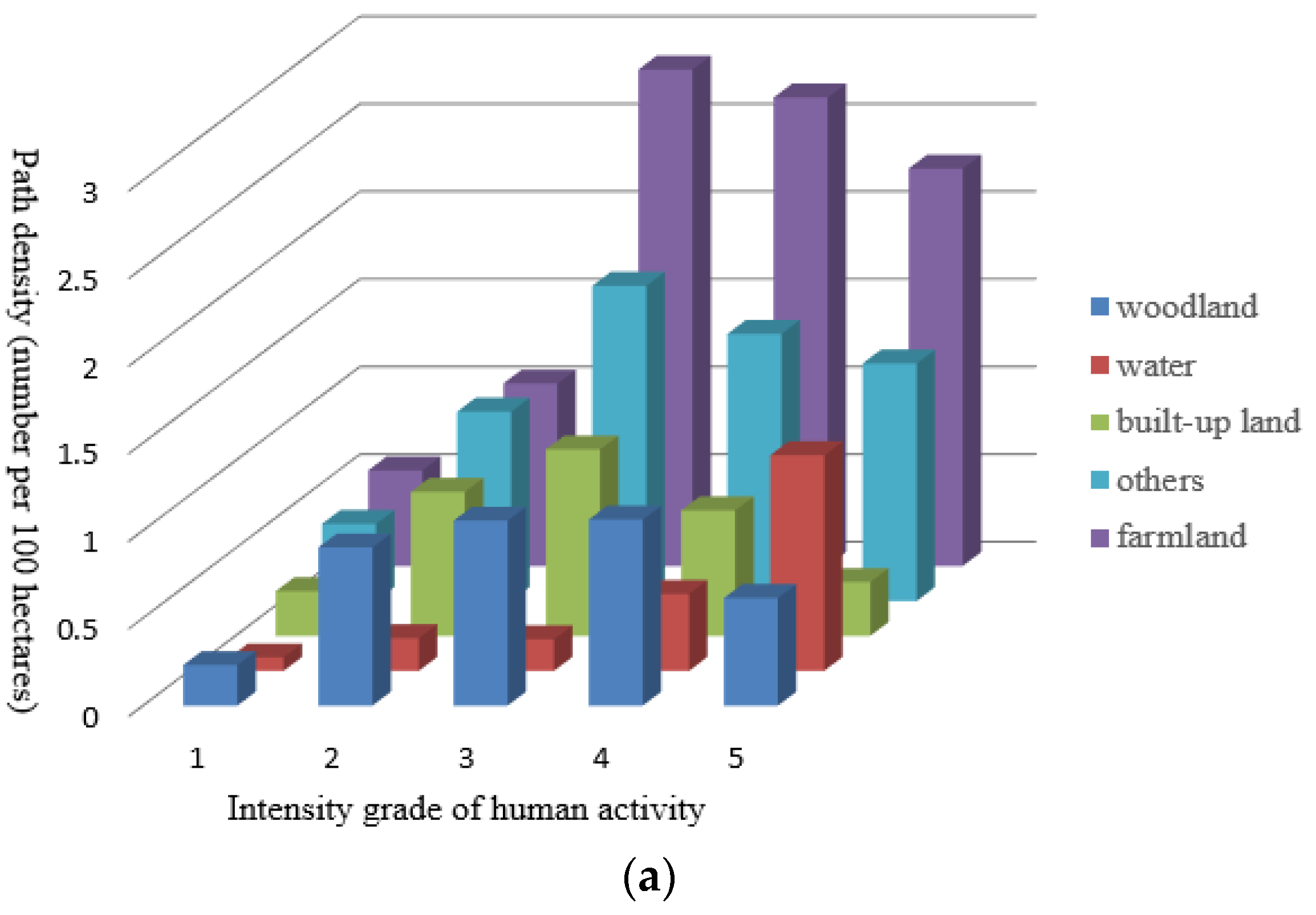
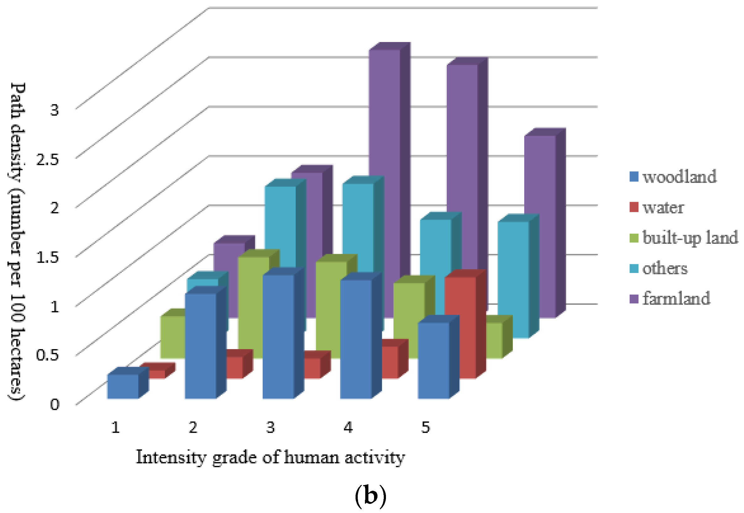
3.3. Interaction Analysis Result between Human Activity and Landscape Pattern
4. Conclusions
- (1)
- Participatory sensing data are field-based, while remote sensing images are raster-based. These two datasets represent information in two completely different forms, which brings difficulties to the integrated analysis of data. How to build a model or devise a method to compare, overlay and fuse these two types of data would be a key problem to solve.
- (2)
- Every type of participatory sensing data is collected or created by a certain group of people and, thus, represents the activity of part of the entire population. In order to allow the analysis result based on participatory sensing data be more representative, more sources or forms of participatory sensing data need to be used. Therefore, the fusion analysis of multiple sources of data needs to be considered.
- (3)
- This study explores the interaction between human activity and landscape pattern from the point of view of intensity and ignores the type difference of the population. In fact, personal experience and the utility function also play a role in the effect of the landscape on humans. For example, favorite sites attract visitors because of the restorative effect caused by feelings, such as calm, happiness and being away from everyday life [53,54], but for local people, the visual characteristics of the landscapes are not as important as their functions [10]. Therefore, how the type of population influences the interaction between human and landscape would be focused on in the future.
Acknowledgments
Author Contributions
Conflicts of Interest
References
- Werner, B.T.; McNamara, D.E. Dynamics of coupled human-landscape systems. Geomorphology 2007, 91, 393–407. [Google Scholar] [CrossRef]
- Pan, Y. Human activities and geographical conditions. Yunnan Geogr. Environ. Res. 1990, 2, 19–28. [Google Scholar]
- Brad, M.A.; Gopalakrishnan, S.; McNamara, D.E.; Smith, M.D. Progress in coupling models of human and coastal landscape change. Comput. Geosci. 2013, 53, 30–38. [Google Scholar] [CrossRef]
- Liu, Y.; Luo, T.; Liu, Z.; Kong, X.; Li, J.; Tan, R. A comparative analysis of urban and rural construction land use change and driving forces: Implications for urban-rural coordination development in Wuhan, Central China. Habitat Int. 2015, 47, 113–125. [Google Scholar] [CrossRef]
- Vitousek, P.M.; Mooney, H.A.; Lubchenco, J.; Melillo, J.M. Human domination of earth’s ecosystems. Science 1997, 277, 494–499. [Google Scholar] [CrossRef]
- Lambin, E.F.; Geist, H.J. Regional differences in tropical deforestration. Environment 2003, 45, 22–36. [Google Scholar] [CrossRef]
- Bucała, A. The impact of human activities on land use and land cover changes and environmental processes in the Gorce Mountains (Western Polish Carpathians) in the past 50 years. J. Environ. Manag. 2014, 138, 4–14. [Google Scholar] [CrossRef] [PubMed]
- Hoozemans, F.M.; Marchand, M.; Pennekamp, H.A. A Global Vulnerability Analysis: Vulnerability Assessment for Population, Coastal Wetlands and Rice Production on a Global Scale, 2nd ed.; Delft Hydraul: Delft, The Netherlands, 1993. [Google Scholar]
- Fu, B.; Lu, Y.; Chen, L.; Su, C.; Yao, X.; Liu, Y. The latest progress of landscape ecology in the world. China Acta Ecol. Sin. 2008, 28, 798–804. [Google Scholar]
- Di Giulio, M.; Holderegger, R.; Tobias, S. Effects of habitat and landscape fragmentation on humans and biodiversity in densely populated landscapes. J. Environ. Manag. 2009, 90, 2959–2968. [Google Scholar] [CrossRef] [PubMed]
- Ministry of Forest and Soil Conservation. Sagarmatha National Park Management and Tourism Plan 2007–2012; Ministry of Forest and Soil Conservation: Kathmandu, Nepal, 2007. [Google Scholar]
- Nagendra, H.; Southworth, J.; Tucker, C. Accessibility as a determinant of landscape transformation in western Honduras: Linking pattern and process. Landsc. Ecol. 2003, 18, 141–158. [Google Scholar] [CrossRef]
- Ferrier, S.; Drielsma, M. Synthesis of pattern and process in biodiversity conservation assessment: A flexible whole-landscape modelling framework. Divers. Distrib. 2010, 16, 386–402. [Google Scholar] [CrossRef]
- Hudson, P.F.; LaFevor, M.C. Managing and monitoring human impacts on landscapes for environmental change and sustainability. J. Environ. Manag. 2014, 138, 1–3. [Google Scholar] [CrossRef] [PubMed]
- Yao, Y.; Liang, S.; Qin, Q.M.; Wang, K.; Zhao, S. Monitoring global land surface drought based on a hybrid evapotranspiration model. Int. J. Appl. Earth Obs. Geoinf. 2011, 13, 447–457. [Google Scholar] [CrossRef]
- Martinez, C.E.; García-Martin, A.; Longares, A.L.A.; Luis, M. Evaluation of forest cover change using remote sensing techniques and landscape metrics in Moncayo Natural Park (Spain). Appl. Geogr. 2015, 62, 247–255. [Google Scholar] [CrossRef]
- Liu, X.; Li, X.; Tan, Z.; Chen, Y. Zoning farmland protection under spatial constraints by integrating remote sensing, GIS and artificial immune systems. Int. J. Geogr. Inf. Sci. 2011, 25, 1829–1848. [Google Scholar] [CrossRef]
- Zhou, K.; Liu, Y.; Tan, R.; Song, Y. Urban dynamics, landscape ecological security, and policy implications: A case study from the Wuhan area of central China. Cities 2014, 41, 141–153. [Google Scholar] [CrossRef]
- Dufour, S.; Rinaldi, M.; Piégay, H.; Michalon, A. How do river dynamics and human influences affect the landscape pattern of fluvial corridors? Lessons from the Magra River, Central-Northern Italy. Landsc. Urban Plan. 2015, 134, 107–118. [Google Scholar] [CrossRef]
- Siyuan, W.; Jingshi, L.; Cunjian, Y. Temporal change in the landscape erosion pattern in the Yellow River Basin, China. Int. J. Geogr. Inf. Sci. 2007, 21, 1077–1092. [Google Scholar] [CrossRef]
- Geri, F.; Amici, V.; Rocchini, D. Human activity impact on the heterogeneity of a Mediterranean landscape. Appl. Geogr. 2010, 30, 370–379. [Google Scholar] [CrossRef]
- Lü, Y.; Chen, L.; Fu, B. The analysis of human activities and landscape pattern at the county level. Acta Ecol. Sin. 2004, 24, 1833–1838. [Google Scholar]
- Guo, L.; Xia, B.; Yu, S.; Gong, C. Effect of anthropogenic disturbances on the temporal-spatial changes of landscape patterns at Taishan Moutain. Chin. J. Eco-Agric. 2006, 14, 235–239. [Google Scholar]
- Gu, D.; Zhang, Y.; Fu, J. The landscape pattern characteristics of coastal wetlands in Jiaozhou Bay under the impact of human activities. Environ. Monit. Assess. 2007, 124, 361–370. [Google Scholar] [CrossRef] [PubMed]
- Hoang, H.T.T.; Vanacker, V.; Van Rompaey, A.; Vu, K.C.; Nguyen, A.T. Changing human-landscape interactions after development of tourism in the northern Vietnamese Highlands. Anthropocene 2014, 5, 42–51. [Google Scholar] [CrossRef]
- Zeng, H.; Kong, N.; Li, S.J. Human impacts on landscape structure in Wolong Natural Reserve. China Acta Ecol. Sin. 2001, 21, 1994–2001. [Google Scholar]
- Garbarino, M.; Lingua, E.; Marzano, R.; Urbinati, C.; Bhuju, D.; Carrer, M. Human interactions with forest landscape in the Khumbu valley, Nepal. Anthropocene 2014, 6, 39–47. [Google Scholar] [CrossRef]
- Goldman, J.; Shilton, K.; Jeff, B.; Estrin, D.; Hansen, M.; Ramanathan, N.; Reddy, S.; Samanta, V. Participatory Sensing: A Citizen-Powered Approach to Illuminating the Patterns that Shape our World; Woodrow Wilson International Center for Scholars: Washington, DC, USA, 2009. [Google Scholar]
- Zheng, Y.; Zhang, L.; Ma, Z.; Xie, X.; Ma, W. Recommending friends and locations based on individual location history. ACM Trans. Web 2011, 5. [Google Scholar] [CrossRef]
- Li, J.; Qin, Q.; Han, J.; Tang, L.A.; Lei, K.H. Mining trajectory data and geotagged data in social media for road map inference. Trans. GIS 2015, 19, 1–18. [Google Scholar] [CrossRef]
- Ratti, C.; Williams, S.; Frenchman, D.; Pulselli, R. Mobile landscapes: Using location data from cell phones for urban analysis. Environ. Plan. B Plan. Des. 2006, 33, 727–748. [Google Scholar] [CrossRef]
- Liu, Y.; Kang, C.; Gao, S.; Xiao, Y.; Tian, Y. Understanding intra-urban trip patterns from taxi trajectory data. J. Geogr. Syst. 2012, 14, 463–483. [Google Scholar] [CrossRef]
- Guilin Chorography Office. Guilin Chorography (1991–2005); Guilin Chorography Office: Guilin, China, 2011. [Google Scholar]
- Xiang, W.; Li, X.; Ding, T.; Huang, Y.; He, C.; Lu, S. Analysis on the vegetation landscape pattern of upper reaches in Lijiang River Basin. Guangxi Sci. 2009, 16, 455–459. [Google Scholar]
- Xiang, Y.; Meng, J. temporal and spatial analysis of tourism disturbance on landscape pattern in the Li River Basin of Guangxi. Mt. Res. 2014, 32, 11–20. [Google Scholar]
- Irish, R.R. Landsat-7 automatic cloud cover assessment algorithms for multispectral, hyperspectral, and ultraspectral imagery. Int. Soc. Opt. Eng. 2000, 4049, 348–355. [Google Scholar]
- National Bureau of Statistics of the People’s Republic of China, Statistical Bulletin of National Economy and Social Development of China in 2012. Available online: http://www.gov.cn/gzdt/2013-02/22/content_2338098.htm (accessed on 2 June 2016).
- Guangxi Zhuang Autonomous Region Bureau of Statistics, Statistical Bulletin of Economy and Social Development of Guangxi in 2012. Available online: http://www.gxtj.gov.cn/fzlm/zdgz/201304/t20130401_26110.html (accessed on 2 June 2016).
- Lucas, R.; Rowlands, A.; Brown, A.; Keyworth, S.; Bunting, P. Rule-based classification of multi-temporal satellite imagery for habitat and agricultural land cover mapping. ISPRS J. Photogramm. Remote Sens. 2007, 62, 165–185. [Google Scholar] [CrossRef]
- Rahman, M.D.; Saha, R.; Saha, S.K. Multi-resolution segmentation for object-based classification and accuracy assessment of land use/land cover classification using remotely sensed data. J. Indian Soc. Remote Sens. 2008, 36, 189–201. [Google Scholar] [CrossRef]
- Saura, S.; Martinez, M.J. Landscape patterns simulation with a modified random clusters method. Landsc. Ecol. 2000, 15, 661–678. [Google Scholar] [CrossRef]
- Neel, M.C.; McGarigal, K.; Cushman, S.A. Behavior of class-level landscape metrics across gradients of class aggregation and area. Landsc. Ecol. 2004, 19, 435–455. [Google Scholar] [CrossRef]
- McGarigal, K.; Marks, B.J. Spatial Pattern Analysis Program for Quantifying Landscape Structure; General Technical Report PNW-GTR-351; US Department of Agriculture, Forest Service, Pacific Northwest Research Station: Portland, OR, USA, 1995. [Google Scholar]
- Zhao, Y.; Qin, Q.M.; Li, J.; Xie, C.; Chen, R.Q. Highway map matching algorithm based on floating car data. In Proceedings of the 2012 IEEE International Geoscience and Remote Sensing Symposium, Munich, Germany, 22–27 July 2012.
- Rosenblatt, M. Remarks on some nonparametric estimates of a density function. Ann. Math. Stat. 1956, 27, 832–837. [Google Scholar] [CrossRef]
- Parzen, E. On estimation of a probability density function and mode. Ann. Math. Stat. 1962, 33, 1065–1076. [Google Scholar] [CrossRef]
- Kong, N.N.; Zeng, H.; Li, S.J. A study of the spatial distribution characteristics of human landscape impact in Wolong National Reserve, Sichuan Province. Acta Sci. Nat. Univ. Pekin. 2002, 38, 393–399. [Google Scholar]
- Ulrich, R. Aesthetic and affective response to natural environment. In Behavior and the Natural Environment; Altman, I., Wohlwill, J., Eds.; Springer: New York, NY, USA, 1983; pp. 85–125. [Google Scholar]
- Hunziker, M.; Kienast, F. Potential impacts of changing agricultural activities on scenic beauty—A prototypical technique for automated rapid assessment. Landsc. Ecol. 1999, 14, 161–176. [Google Scholar] [CrossRef]
- Mao, X.; Meng, J.; Wang, Q. Modeling the effects of tourism and land regulation on land-use change in tourist regions: A case study of the Lijiang River Basin in Guilin, China. Land Use Policy 2014, 41, 368–377. [Google Scholar] [CrossRef]
- Fu, B.; Zhao, W.; Chen, L. Progress and perspective of geographical-ecological progresses. Acta Geogr. Sin. 2006, 61, 1123–1131. [Google Scholar]
- Wu, J. Landscape Ecology: Pattern, Process, Scale and Hierachy; Higher Education Press: Beijing, China, 2007. [Google Scholar]
- Korpela, K.; Hartig, T. Restorative qualities of favorite places. J. Environ. Psychol. 1996, 16, 221–233. [Google Scholar] [CrossRef]
- Korpela, K.M.; Hartig, T.; Kaiser, F.G.; Fuhrer, U. Restorative experience and self-regulation in favorite places. Environ. Behav. 2001, 33, 572–589. [Google Scholar] [CrossRef]


| Vehicle ID | Province ID | Longitude | Latitude | Speed | Direction | Collection Time |
|---|---|---|---|---|---|---|
| MUI712230 | 450000 | 110.081383 | 25.454500 | 57 | 351 | 1 July 2012 10:24:55 |
| MUI712230 | 450000 | 110.080466 | 25.459466 | 46 | 348 | 1 July 2012 10:25:35 |
| MUI712230 | 450000 | 110.078700 | 25.463833 | 33 | 326 | 1 July 2012 10:26:15 |
| MUI712230 | 450000 | 110.078133 | 25.464933 | 22 | 353 | 1 July 2012 10:26:55 |
| MUI712230 | 450000 | 110.077450 | 25.469683 | 48 | 353 | 1 July 2012 10:27:35 |
| MUI712230 | 450000 | 110.075650 | 25.474800 | 54 | 346 | 1 July 2012 10:28:15 |
| MUI712230 | 450000 | 110.074383 | 25.480733 | 80 | 352 | 1 July 2012 10:28:48 |
| MUI712230 | 450000 | 110.074216 | 25.481900 | 76 | 352 | 1 July 2012 10:28:54 |
| MUE243722 | 450000 | 110.105316 | 25.353883 | 59 | 11 | 1 July 2012 08:20:58 |
| MUE243722 | 450000 | 110.104600 | 25.355566 | 63 | 311 | 1 July 2012 08:21:11 |
| MUE243722 | 450000 | 110.103216 | 25.356683 | 67 | 313 | 1 July 2012 08:21:21 |
| Grade | Intensity Range | Typical Covering Area |
|---|---|---|
| 1 | 0–500 | Nature dominant area |
| 2 | 500–3000 | Road dominant area |
| 3 | 3000–10,000 | Suburban area |
| 4 | 10,000–20,000 | City core belt |
| 5 | 20,000–max | City core area |
| Metrics | Component Measured | Units | 2009 | 2013 | Change (%) |
|---|---|---|---|---|---|
| PD | Density | n/100 ha | 1.7139 | 2.3316 | 36.04 |
| ED | Edge | m/ha | 30.5714 | 34.3983 | 12.52 |
| SHDI | Diversity | - | 0.8684 | 0.8323 | −4.16 |
| CONTAG | Aggregation | % | 66.3172 | 66.1679 | −0.23 |
| PROX_MN | Proximity | - | 13,319.85 | 12,723.13 | −4.5 |
| SHAPE_MN | shape | - | 1.6625 | 1.6324 | −1.81 |
| TCA | Core Area | ha | 441,158.04 | 418,996.26 | −5.0 |
| DCAD | Core Area | n/100 ha | 1.0761 | 1.2264 | 14.0 |
| Land Class | Year | NP (n) | PD (n/100 ha) | ED (m/ha) | PROX_MN | SHAPE_MN | TCA (ha) | DCAD (n/100 ha) |
|---|---|---|---|---|---|---|---|---|
| woodland | 2009 | 2118 | 0.2665 | 17.5358 | 71,861.5667 | 1.6327 | 377,188.3 | 0.3969 |
| 2013 | 2272 | 0.2859 | 20.6407 | 99,686.3262 | 1.6605 | 378,656.3 | 0.4601 | |
| water | 2009 | 637 | 0.0802 | 2.8799 | 50.5259 | 2.2662 | 1232.1 | 0.018 |
| 2013 | 723 | 0.091 | 2.9725 | 42.5183 | 2.2502 | 1000.08 | 0.0185 | |
| built-up land | 2009 | 2400 | 0.302 | 7.1102 | 374.464 | 1.5994 | 7419.15 | 0.1505 |
| 2013 | 3603 | 0.4534 | 11.1942 | 693.0281 | 1.6454 | 10,914.3 | 0.2137 | |
| farmland | 2009 | 4316 | 0.5432 | 27.1928 | 6529.0928 | 1.9223 | 51,542.28 | 0.4166 |
| 2013 | 6181 | 0.7779 | 28.4589 | 1079.4364 | 1.8994 | 27,726.57 | 0.4902 | |
| others | 2009 | 4148 | 0.522 | 5.7532 | 21.6444 | 1.3513 | 3776.22 | 0.0941 |
| 2013 | 5748 | 0.7234 | 6.8593 | 5.9835 | 1.2482 | 699.03 | 0.0439 |
© 2016 by the authors; licensee MDPI, Basel, Switzerland. This article is an open access article distributed under the terms and conditions of the Creative Commons Attribution (CC-BY) license (http://creativecommons.org/licenses/by/4.0/).
Share and Cite
Li, J.; Zhang, Y.; Wang, X.; Qin, Q.; Wei, Z.; Li, J. Application of GPS Trajectory Data for Investigating the Interaction between Human Activity and Landscape Pattern: A Case Study of the Lijiang River Basin, China. ISPRS Int. J. Geo-Inf. 2016, 5, 104. https://doi.org/10.3390/ijgi5070104
Li J, Zhang Y, Wang X, Qin Q, Wei Z, Li J. Application of GPS Trajectory Data for Investigating the Interaction between Human Activity and Landscape Pattern: A Case Study of the Lijiang River Basin, China. ISPRS International Journal of Geo-Information. 2016; 5(7):104. https://doi.org/10.3390/ijgi5070104
Chicago/Turabian StyleLi, Jun, Yuan Zhang, Xiang Wang, Qiming Qin, Zhuangzhuang Wei, and Jingze Li. 2016. "Application of GPS Trajectory Data for Investigating the Interaction between Human Activity and Landscape Pattern: A Case Study of the Lijiang River Basin, China" ISPRS International Journal of Geo-Information 5, no. 7: 104. https://doi.org/10.3390/ijgi5070104
APA StyleLi, J., Zhang, Y., Wang, X., Qin, Q., Wei, Z., & Li, J. (2016). Application of GPS Trajectory Data for Investigating the Interaction between Human Activity and Landscape Pattern: A Case Study of the Lijiang River Basin, China. ISPRS International Journal of Geo-Information, 5(7), 104. https://doi.org/10.3390/ijgi5070104