
Soil Moisture Mapping in an Arid Area Using a Land Unit Area (LUA) Sampling Approach and Geostatistical Interpolation Techniques


Abstract
:1. Introduction
2. Materials and Methods
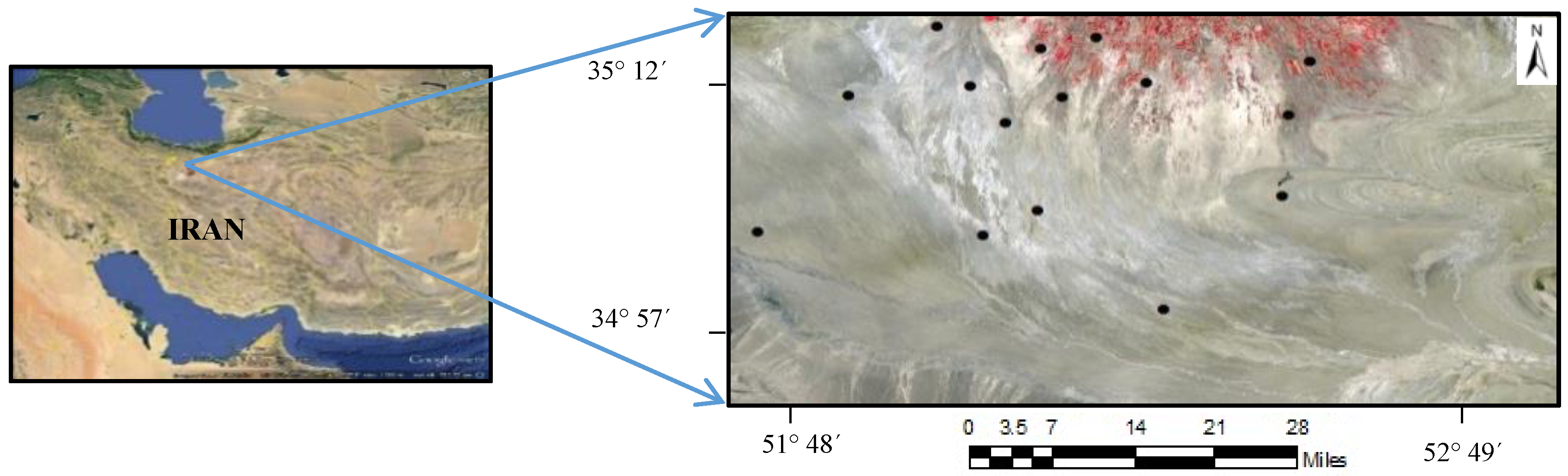
2.1. Study Area
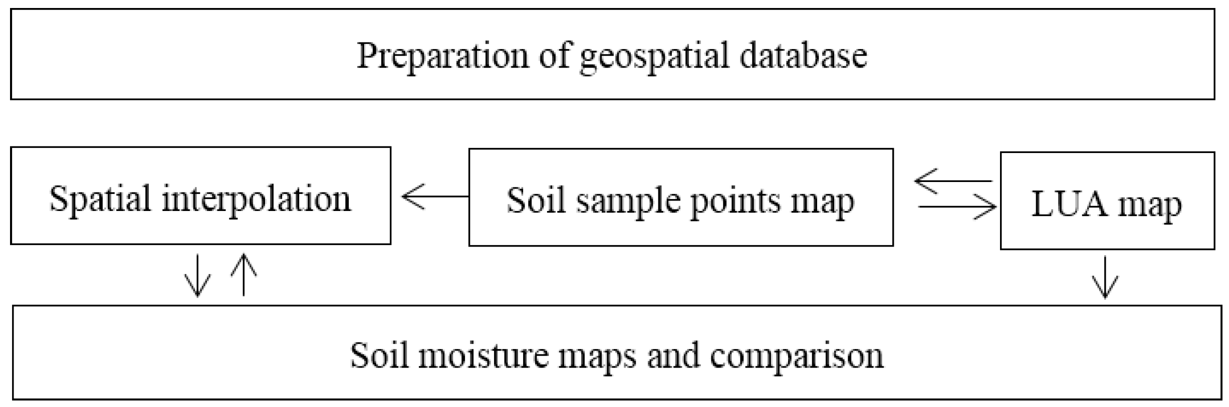
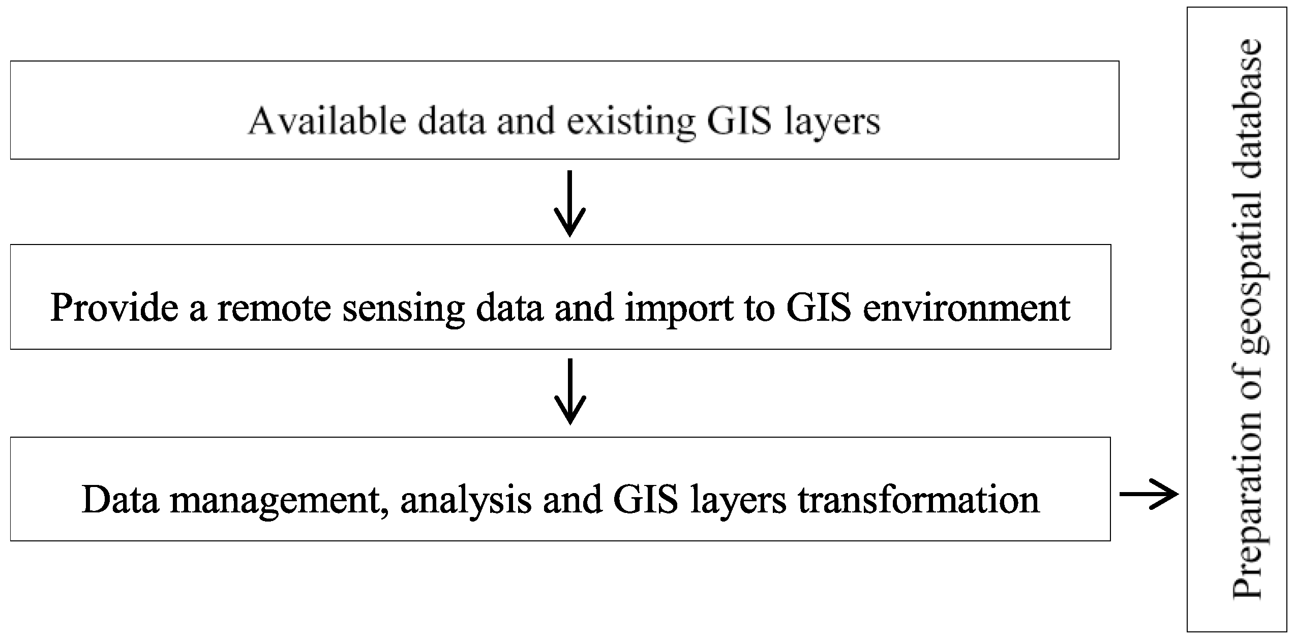
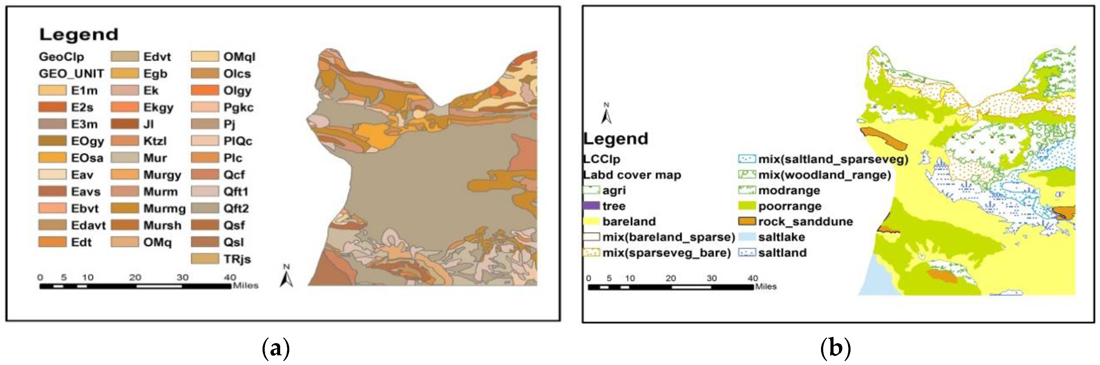
2.2. Preparation of the Geospatial Database
- Land cover/use map of Semnan province, produced by Landsat ETM+ and TM by Semnan Agriculture Research Organization
- Geological map at a scale of 1:100,000, which was produced in 2010 by Geological Surveying Organization (This map is created in hard copy and digital format based on the aerial photography, geological interpretation, and field work checking)
- The 90 m Digital Elevation Model (DEM)
- Climate data such as precipitation, temperature, and evapotranspiration which was produced by the Meteorological Organization of Semnan province
- Vegetation cover percentage which was produced by the Forest, Rangeland and Watershed Organization
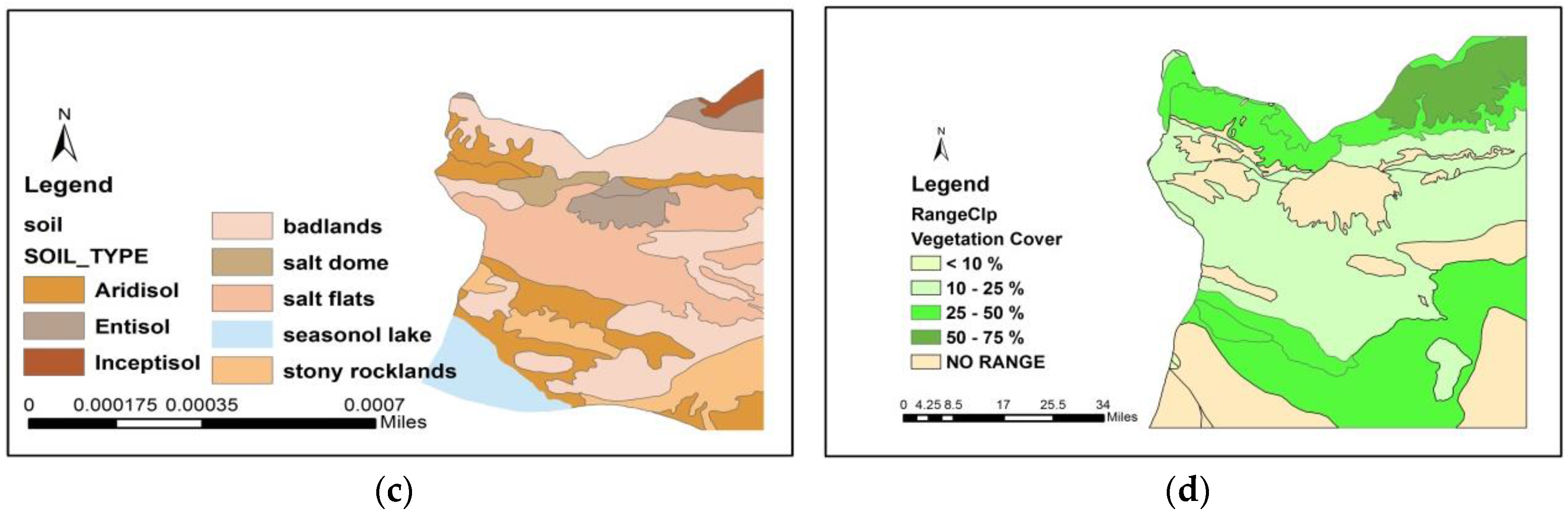
- Soil types and soil regime layers, which were created by the Soil and Water Conservation Institute
- Provide the remote sensing data layers (i.e., water, soil, and vegetation indexes)
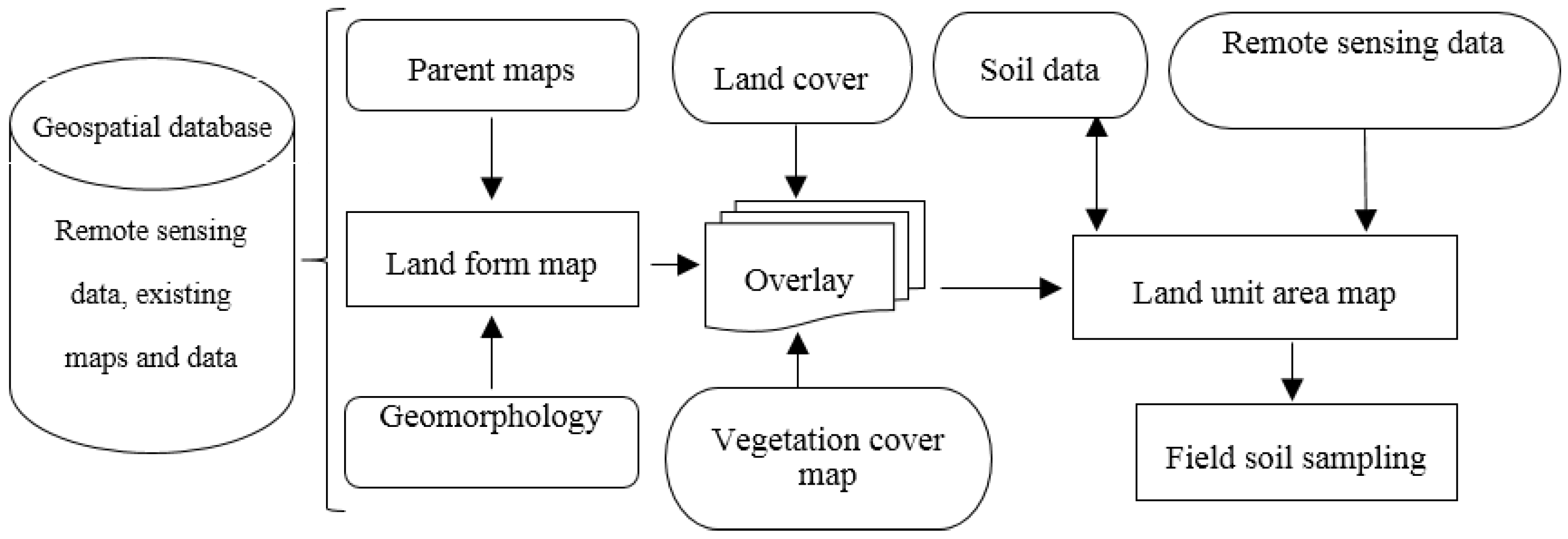
2.3. Derivation of the LUA Map
- (1)
- Geology
- (2)
- Soil information (types, regime)
- (3)
- DEM (topography, slope, curvature)
- (4)
- Land cover/land use
- (5)
- Vegetation cover
- (6)
- DEM (topography, slope, curvature)
- (7)
- Geomorphology
- (8)
- Climate data (rainfall, temperature, evapotranspiration)
- (9)
- Remote sensing information (NDMI and land surface temperature)
- (10)
- Landform
- Reclassification and standardization of the production remote sensing data (land cover/use)
- Production of the base maps (climate, vegetation, lithology)
- Import to the GIS environment
- Create the landform map using geomorphology map and DEM (slope and curvature)
- Overlaying the parent maps, geomorphology, and vegetation cover to create the landform
- Producing the remote sensing data layers (i.e., surface temperature, moisture index)
- Evaluation and addition of the soil data (soil types, soil regime)
- Creation of the geospatial database in GIS to produce the land unit area (LUA) map
- Produced the remote sensing data of Landsat ETM+ (13 September 2013) (e.g., NDMI and surface temperature)
- Visual interpretation and validation of the LUA map by remote sensing data layers
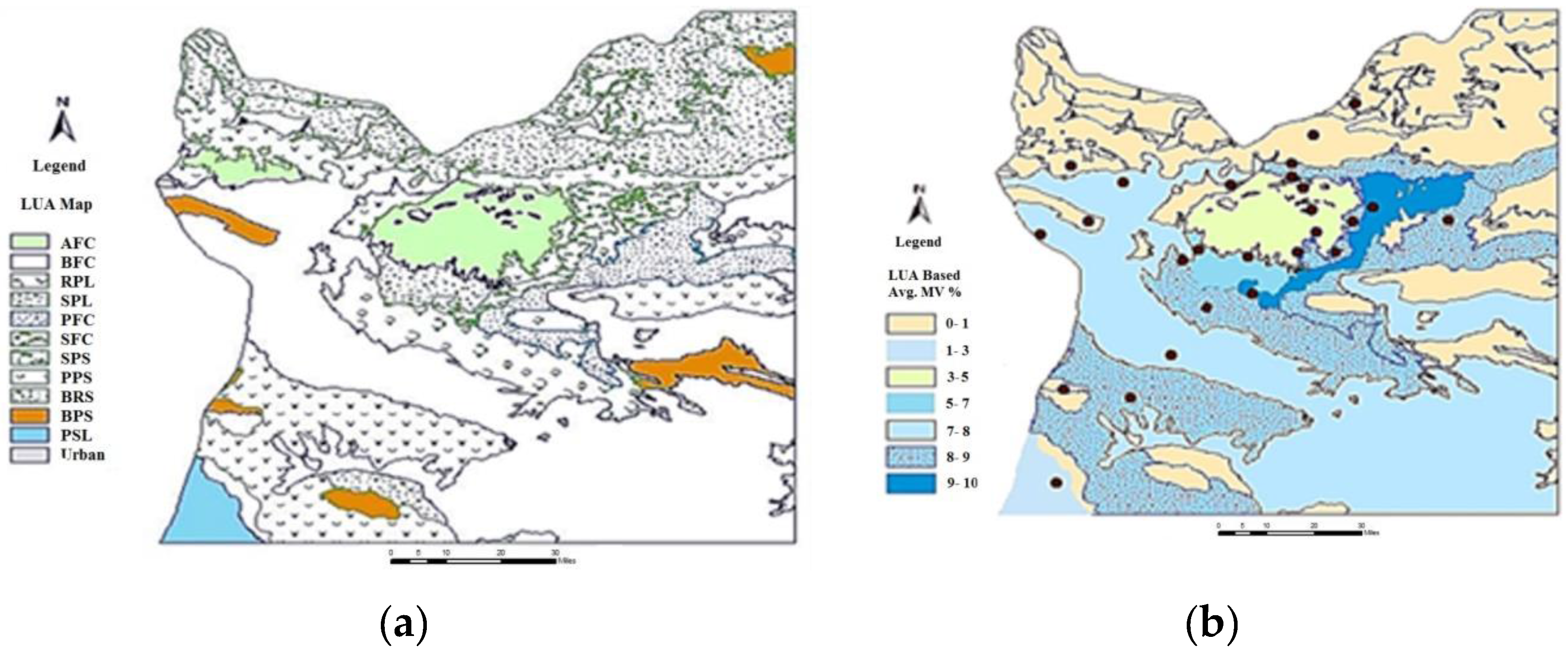
- Using the LUA map as the final guidance map for field soil sampling
- Measuring the SM points in each LUA polygon by TDR
- Creating the SM map using sample points of field and LUA map in GIS
- Using the geostatistical interpolation method in GIS to generate the SM map
- Evaluation and comparison of SM maps of LUA, geostatistical, and NDMI
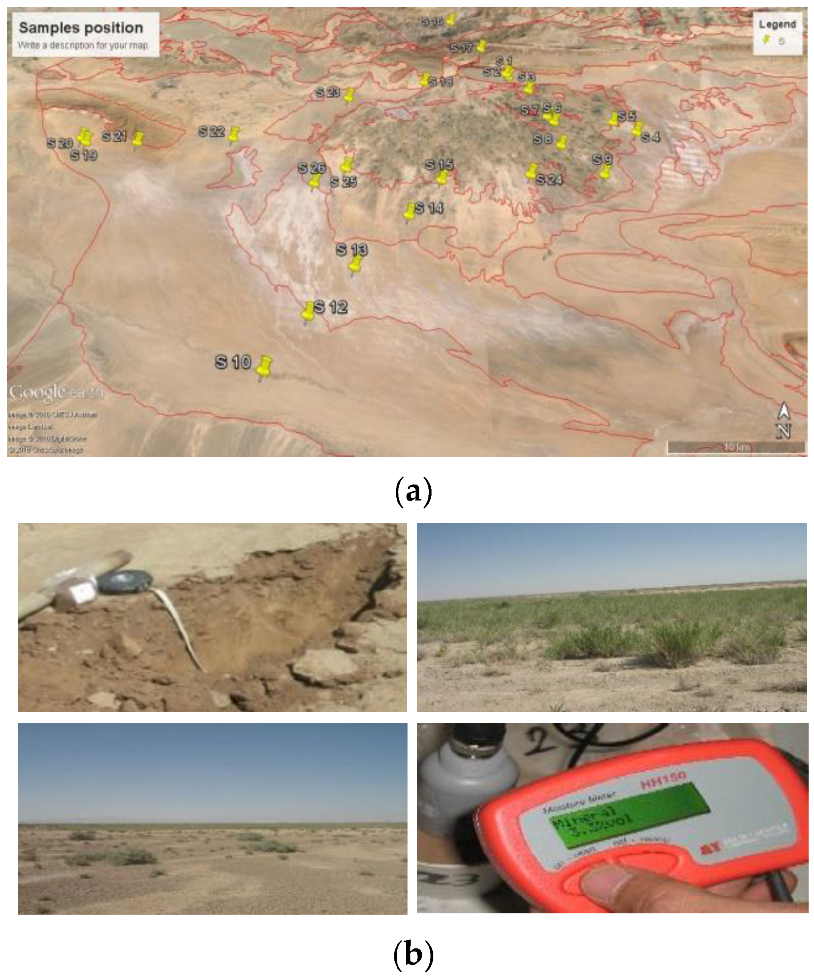
2.4. Field Survey of SM
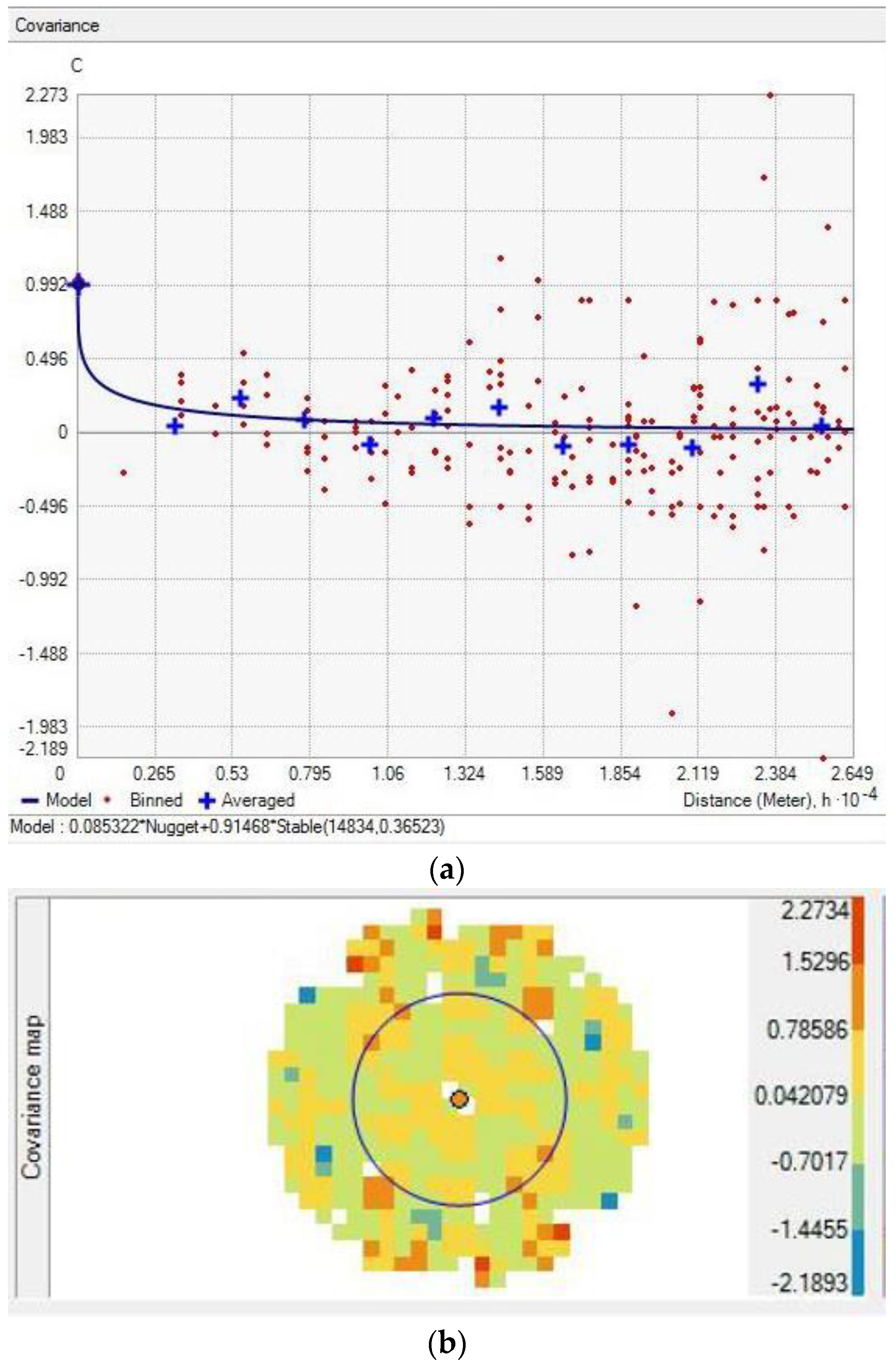
2.5. Spatial Interpolation Methods
- A structural component, associated with a constant mean value or a polynomial trend;
- A spatially-correlated random component (auto-correlative component); and
- A white noise or residual error term that is spatially uncorrelated
2.6. Creation of SM Maps
3. Results and Discussion
3.1. Geospatial Database to Produce the LUA Map
3.2. Land Unit Area (LUA) Map Production
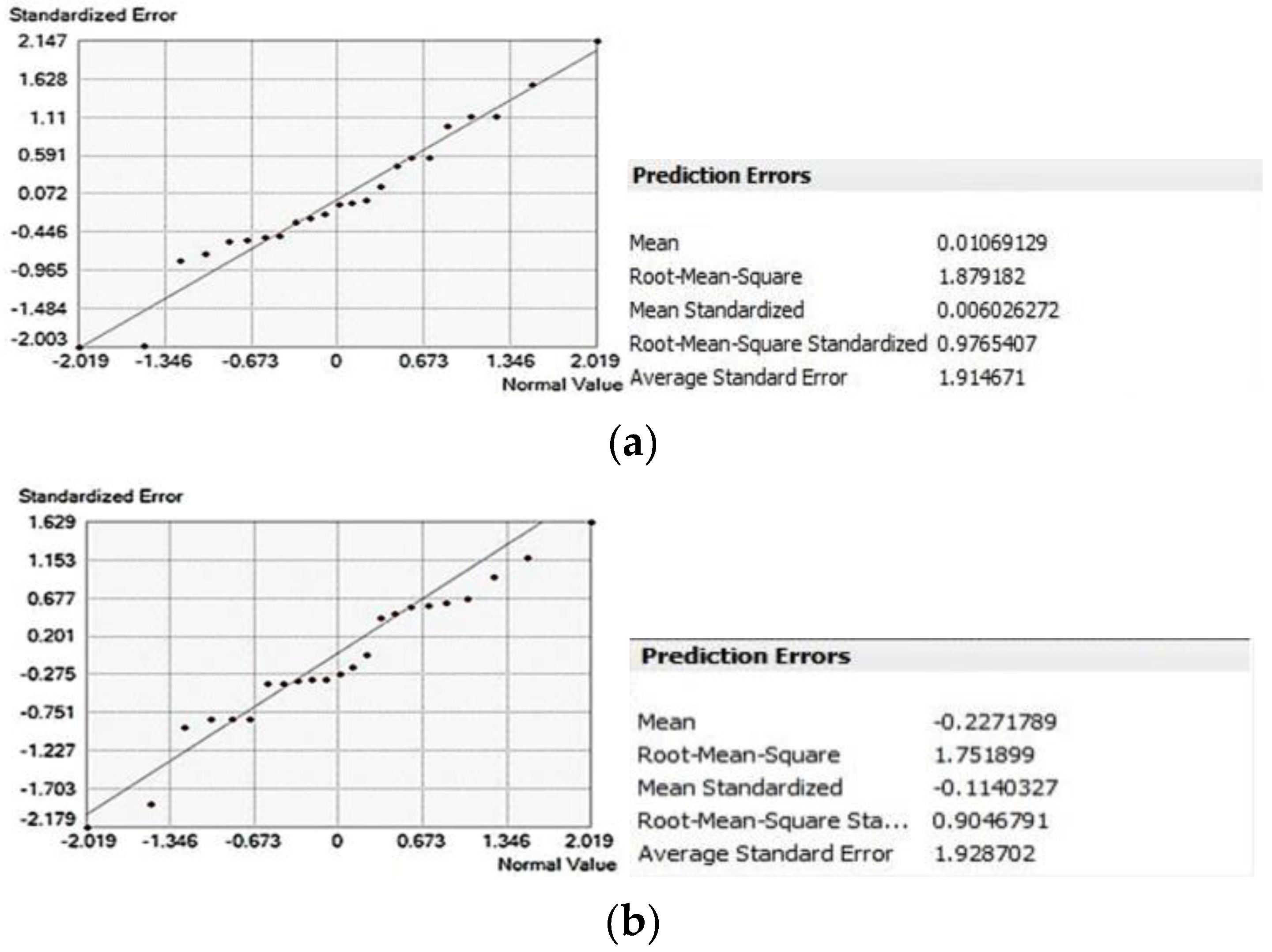
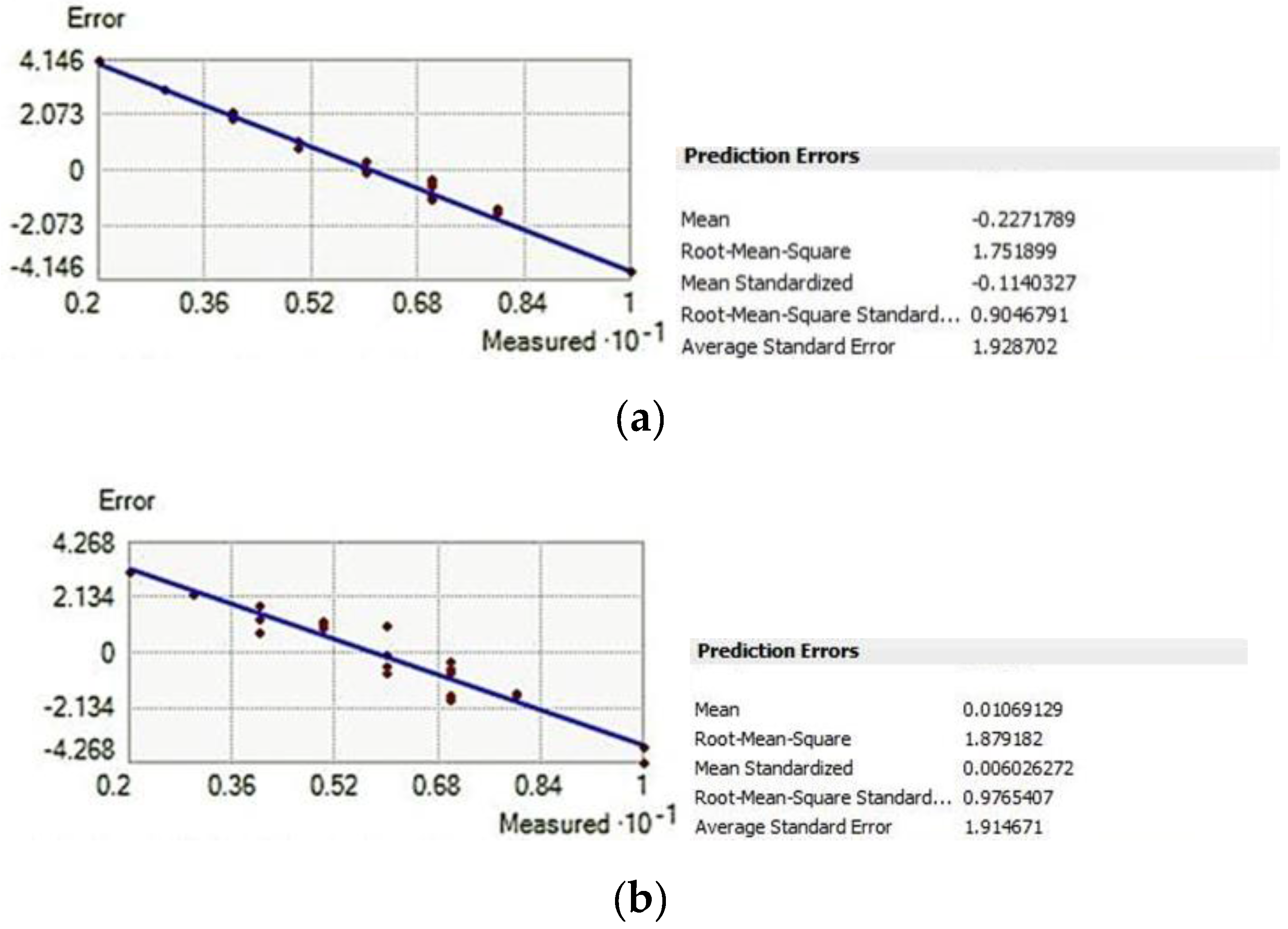
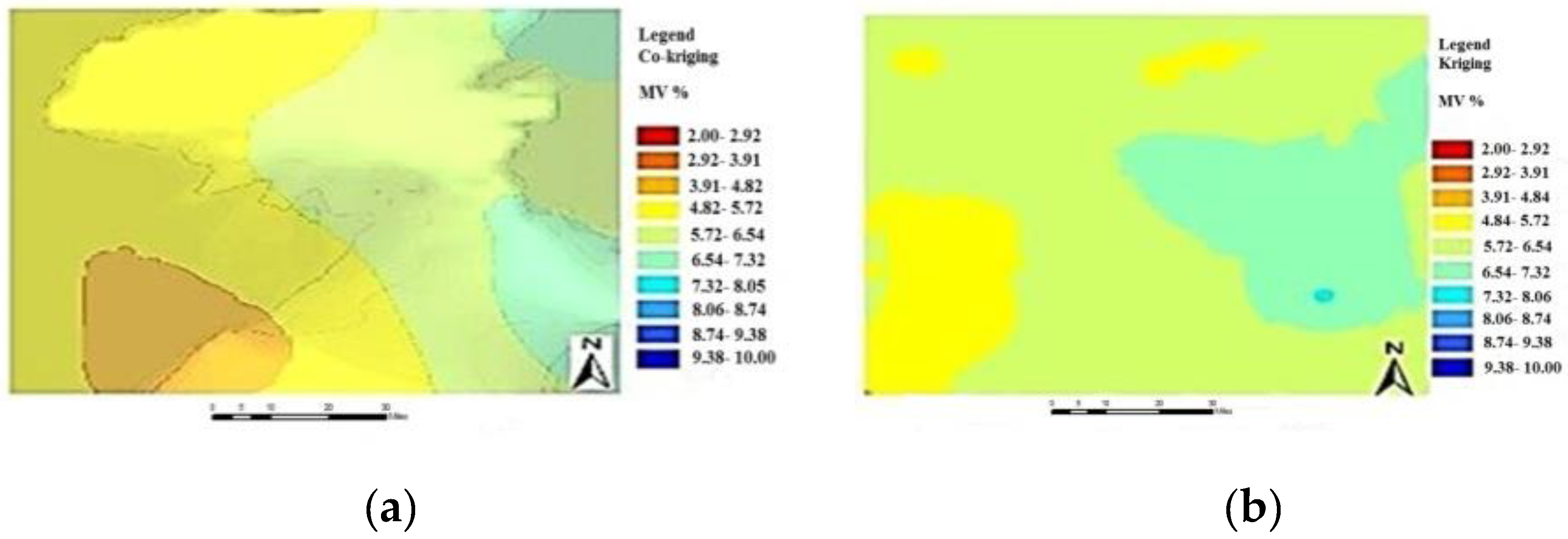
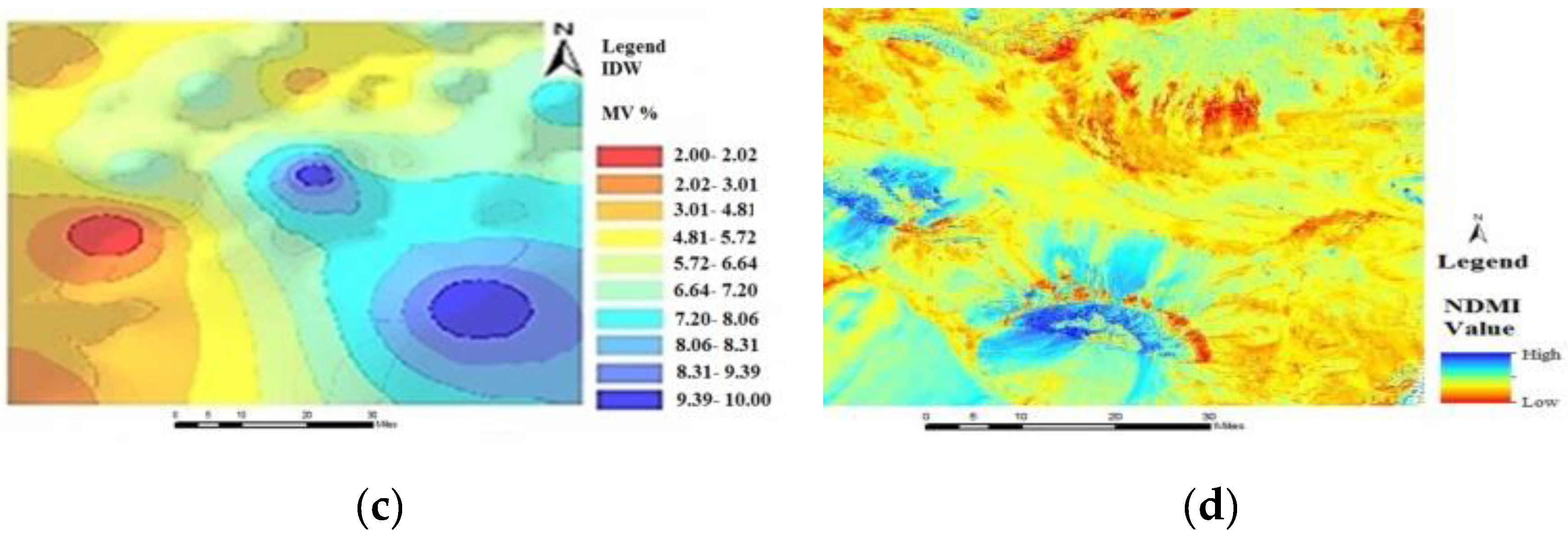
3.3. SM Mapping Using the Spatial Interpolation Method and Comparison
4. Conclusions
Author Contributions
Conflicts of Interest
References
- Yuanyuan, D.; Yong, W. Research on the spatial interpolation methods of SM based on GIS. In Proceedings of the International Conference on Information Science and Technology, Nanjing, China, 26–28 March 2011; pp. 26–28.
- Jin, S.; Andrew, D.H. A review of comparative spatial interpolation method in environmental sciences: Performance and impact factor. J. Ecol. Inform. 2010, 6, 228–241. [Google Scholar]
- Tomislav, H.; Gerard, B.M.H.; David, G.R. About regression-Kriging: From equation to case studies. Comput. Geosci. 2007, 33, 1301–1315. [Google Scholar]
- Wei, S.; Budiman, M.; Alex, M. Analysis and prediction of soil properties using local regression-Kriging. Geoderma 2010, 171–173, 16–23. [Google Scholar]
- Zhao, P.P.; Shao, M. Soil water spatial distribution in dam farmland on the Loess Plateau, China. Acta Agric. Scand. 2010, 60, 117–125. [Google Scholar] [CrossRef]
- Takagi, K.; Lin, H.S. Changing controls of soil moisture spatial organization in the Shale Hills Catchment. Geoderma 2012, 173–174, 289–302. [Google Scholar] [CrossRef]
- Zhu, Q.; Lin, H.S. Comparing ordinary Kriging and regression Kriging for soil properties in contrasting landscapes. Pedosphere 2010, 20, 594–606. [Google Scholar] [CrossRef]
- Bishop, T.F.A.; McBratney, A.B. A comparison of prediction methods for the creation of field-extent soil property maps. Geoderma 2001, 103, 149–160. [Google Scholar] [CrossRef]
- Xueling, Y.; Bojie, F.; Yihe, L.; Ruiying, C.; Shuai, W.; Yafeng, W.; Changhong, S. The multi-scale spatial variance of SM in the semi-arid Loess Plateau of China. J. Soils Sediment. 2012, 12, 694–703. [Google Scholar]
- Rosenbaum, U.; Bogena, H.R.; Herbst, M.; Huisman, J.A.; Peterson, T.J.; Weuthen, A.; Western, A.W.; Vereecken, H. Seasonal and event dynamics of spatial SM patterns at the small catchment scale. Water Resour. Res. 2012, 48. [Google Scholar] [CrossRef]
- De Benedetto, D.; Castrignanò, A.; Quarto, R. A geostatistical approach to estimate SM as a function of geophysical data and soil attributes. Proced. Environ. Sci. 2013, 19, 436–445. [Google Scholar]
- Yao, X.; Fu, B.; Lü, Y.; Sun, F.; Wang, S.; Liu, M. Comparison of four spatial interpolation methods for estimating SM in a complex terrain catchment. PLoS ONE 2013, 8, e54660. [Google Scholar]
- Mohamed, M.Y.; Abdo, B.M. Spatial variability mapping of some soil properties in El-Multagha agricultural project (Sudan) using geographic information systems (GIS) techniques. J. Soil Sci. Environ. Manag. 2011, 2, 58–65. [Google Scholar]
- Han, X.; Li, X.; Hendricks Franssen, H.J.; Vereecken, H.; Montzka, C. Spatial horizontal correlation characteristics in the land data assimilation of SM. Hydrol. Earth Syst. Sci. 2012, 16, 1349–1363. [Google Scholar] [CrossRef]
- Marin, P.-G.; Xanat, A.-N.; Jose, A.C.-M.; Martín, A.M.-B. Spatial patterns of soil degradation in Mexico. Afr. J. Agric. Res. 2011, 6, 1109–1113. [Google Scholar]
- He, Y.; Song, H.Y.; Zhang, S.J.; Fang, H. Study on the spatial variability and the sampling scheme of soil nutrients in the field based on GPS and GIS. In Proceedings of the 27th Annual International Conference of the Engineering in Medicine and Biology Society, Shanghai, China, 1–4 September 2005; pp. 5942–5945.
- Diana, A.-F.; Marin, P.-G.; Xanat, A.-N. Driving factors for forest fire occurrence in Durango State of Mexico: A geospatial perspective. Chin. Geogr. Sci. 2010, 20, 491–497. [Google Scholar]
- Goovaerts, P. Geostatistics for Natural Resources Evaluation; Oxford University Press: New York, NY, USA, 1997. [Google Scholar]
- Grunwald, S.; McSweeney, K.; Lowery, B.; Rooney, D. Continuous description of soil attributes on a landscape in Southern Wisconsin. In Proceedings of the ASA-CSA-SSSA Annual Meeting, Baltimore, MA, USA, 18–22 October 2007.
- Jacobs, H.M. Practicing land consolidation in a changing world of land use planning. Kart Plan. 2000, 60, 175–182. [Google Scholar]
- Kevin, J.; Jay, M.; Ver, H.; Konstantin, K.; Neil, L. Using ArcGIS, Geostatistical Analyst. Available online: http://dusk2.geo.orst.edu/gis/geostat_analyst.pdf (accessed on November 2015).
- Harahsheh, H.; Tateishi, R. Environmental GIS database and desertification mapping of West Asia. In Proceedings of the Workshop of the Asian Region Thematic Programme Network on Desertification Monitoring and Assessment, Tokyo, Japan, 28–30 June 2000.
- Zonneveld, I.S. The land unit a fundamental concept in landscape ecology, and its applications. Landsc. Ecol. 1989, 3, 67–86. [Google Scholar] [CrossRef]
- Juergensmeyer, J.C.; Roberts, T.E. Land Use Planning and Development Regulation Law; West Academic Publishing: St Paul, MN, USA, 2013. [Google Scholar]
- Vacca, A.; Marrone, V.A. The land unit and soil capability map of Sardinia (Italy) at a 1: 50,000 scale: The pilot area of Pula-Capoterra. In 20th World Congress of Soil Science, Vienna, Austria, 27 April–2 May 2014; p. 186.
- Papadimitriou, F. Modeling landscape complexity for land use management in Rio de Janeiro, Brazil. Land Use Policy 2012, 29, 855–861. [Google Scholar] [CrossRef]
- Lisio, A.; Russo, F. Thematic maps for land-use planning and policy decisions in the Calaggio stream catchment area. J. Maps. 2010, 6, 68–83. [Google Scholar] [CrossRef]
- Soil Survey Division Staff. Soil Survey Manual 18; U.S. Department of Agriculture: Washington, DC, USA, 1993.
- Upchurch, D.R.; Wilding, L.P.; Hartfield, J.L. Methods to evaluate spatial variability. In Reclamation of Disturbed Lands; CRC Press: Boca Raton, FL, USA, 1988; pp. 201–229. [Google Scholar]
- Vacca, A.; Loddo, S.; Melis, M.T.; Funedda, A.; Puddu, R.; Verona, M.; Fanni, S.; Fantola, F.; Madrau, S.; Marrone, V.A.; et al. A GIS based method for soil mapping in Sardinia, Italy: A geomatic approach. J. Environ. Manag. 2014, 138, 87–96. [Google Scholar] [CrossRef] [PubMed]
- Wilding, L.P.; Bouma, J.; Boss, D.W. Impact of spatial variability on interpretive modeling. Spec. PublSSSA 1994, 39, 61–75. [Google Scholar]
- Bi, H.X.; Li, X.Y.; Liu, X.; Guo, M.X.; Li, J. A case study of spatial heterogeneity of SM in the Loess Plateau, western China: A geostatistical approach. Int. J. Sediment Res. 2009, 24, 63–73. [Google Scholar] [CrossRef]
- Atkinsona, P.M.; Lewisb, P. Geostatistical classification for remote sensing: An introduction. Comput. Geosci. 2000, 26, 361–371. [Google Scholar] [CrossRef]
- Carter, M.R.; Gregorich, E.G. Soil Sampling and Methods of Analysis; CRC Press: Boca Raton, FL, USA, 1993. [Google Scholar]


| Field No. | Soil Texture | Sand % | Silt % | Clay % | SM Vol.% | Land Cover |
|---|---|---|---|---|---|---|
| 14 | Loam | 32.2 | 49.1 | 18.7 | 3.3 | Sparse vegetation |
| 11 | Silt Loam | 20.2 | 65.2 | 14.6 | 6.6 | Bare land |
| 13 | clay | 10.1 | 33.3 | 56.6 | 8.6 | Bare land |
| 12 | Silt clay | 9 | 52 | 39.1 | 5.2 | Sparse vegetation |
| 10 | Loam | 24.2 | 58.1 | 17.7 | 9.5 | Bare land |
| ID | Soil Regime | Soil Type |
|---|---|---|
| 239 | Lithic Calciustepts, Coarse to Medium, Typic Calciustepts, Fluventic, Haploxerepts, Undulating | Inceptisol |
| 603 | Rock Outcrops—Litihic Xerorthents—Typic Haploxerepts, Hilly | Entisol |
| 824 | Typic, Torriorfhents, coarse to medium, Typic, Haplogypsids, Typic, Haplogypsids, Gentiy, Undulatir | Entisol |
| 1105 | Typic, Haplogypsids, Coarse to Medium, Typic, Torriorfhents, Typic, Haplocalcids, Gently, Undulate | Aridisol |
| 1106 | Typic, Haplogypsids, Coarse to Medium, Typic, Torriorfhents, Typic, Haplocalcids, Gently, Undulate | Aridisol |
| 1355 | Xeric, Haplosalids, medium, Xeric ,Torrifluvents, Typic, Aquisalids, level | Aridisol |
| ID | Info |
|---|---|
| AFC | Agriculture with mixed cropland, alluvial, and colluvial parent material, deep soil, loam to clay soil texture |
| BFC | Bare land in plain, alluvial fan, clay soil and silt soil, fine to coarse sandstone, lowland |
| RPL | Rangeland, plain, soil with good depth and fertilizing, clay loam, and clay |
| SPL | Sparse vegetation and mix with crop and follow, plain land with loam and clay soil texture |
| PFC | Smooth plain, fine texture soil with salinity and limitation for drainage, limitation for plants, halophyte plants |
| SFC | Rangeland mix by shrubland, alluvial fan with high ground water table with limitation for farming, coarse to fine soil |
| SPS | Sparse vegetation in rangeland, plain, halophyte plant in winter, little soil saline, loam to clay texture |
| PPS | Poor range, plain, soil salinity limitation, sandy soil, soil erosion |
| BRS | Bare land in rocky mountain, sandstone with undeveloped coarse soil |
| BPS | Badlands with soil with physical and chemical limitation for plants |
| PSL | Plain area, temporal salt lake |
© 2016 by the authors; licensee MDPI, Basel, Switzerland. This article is an open access article distributed under the terms and conditions of the Creative Commons by Attribution (CC-BY) license (http://creativecommons.org/licenses/by/4.0/).
Share and Cite
Gharechelou, S.; Tateishi, R.; Sharma, R.C.; Johnson, B.A. Soil Moisture Mapping in an Arid Area Using a Land Unit Area (LUA) Sampling Approach and Geostatistical Interpolation Techniques. ISPRS Int. J. Geo-Inf. 2016, 5, 35. https://doi.org/10.3390/ijgi5030035
Gharechelou S, Tateishi R, Sharma RC, Johnson BA. Soil Moisture Mapping in an Arid Area Using a Land Unit Area (LUA) Sampling Approach and Geostatistical Interpolation Techniques. ISPRS International Journal of Geo-Information. 2016; 5(3):35. https://doi.org/10.3390/ijgi5030035
Chicago/Turabian StyleGharechelou, Saeid, Ryutaro Tateishi, Ram C. Sharma, and Brian Alan Johnson. 2016. "Soil Moisture Mapping in an Arid Area Using a Land Unit Area (LUA) Sampling Approach and Geostatistical Interpolation Techniques" ISPRS International Journal of Geo-Information 5, no. 3: 35. https://doi.org/10.3390/ijgi5030035
APA StyleGharechelou, S., Tateishi, R., Sharma, R. C., & Johnson, B. A. (2016). Soil Moisture Mapping in an Arid Area Using a Land Unit Area (LUA) Sampling Approach and Geostatistical Interpolation Techniques. ISPRS International Journal of Geo-Information, 5(3), 35. https://doi.org/10.3390/ijgi5030035