1. Introduction
The dynamics of human land use and land cover (LULC) changes have implications for land use and environmental management and planning in peri-urban areas [
1,
2,
3,
4]. In view of this, modelling the human land uses and land cover (LULC) change is essential for the assessment of consequent social and environmental impacts of human activities [
5]. Globally, quite a substantial amount of research has been done on the use of remote sensing and GIS to model the land use and cover dynamics [
6,
7,
8,
9] and [
10]. In peri-urban areas where demand for land meant for various applications persist, it is imperative to assess the degree of LULC changes. This is so, in order to identify the trends and to ascertain the extent of land use types trade-off among the different LULC applications [
11].
Considering the fact that the peri-urban areas are the melting pots of diverse socio-economic undertakings [
12], it is imperative to monitor the trends of land use and cover changes to ensure that these are in sync with the available land space and the rate of population growth over time. Theorizing the construction of land surface change dynamics, Prenzel [
13], examined configuration of the earth surface, in terms of the spatial and structural landscape dynamics over time. In terms of the spatial and structural landscape dynamics, the landscape configuration dynamics should be seen as structural-temporal occurrence changing over time [
7,
13,
14]. In order to categorically and quantitatively analyze these LULC dynamics, remote sensing applications are imperative. This is apparently because the quantitative changes are amenable to remote sensing and geo-information modelling.
Furthermore, Nagarajan and Poongothai [
15] have indicated that human interference and interactions with the land surface result in a variety of outcomes. These varieties of outcomes constitute the LULC change patterns from a complex system [
16]. In this regard, considering the rapid changes in the land use and cover driven by population increases and expended demand for land. It is crucial that accurate and up-to-date land use and cover change information is produced for both human society as well as environmental planning purposes [
17].
According to Addo [
12], the use of remote sensing and GIS tools for the mapping of peri-LULC changes have revealed intriguing results and offered some critical policy recommendations for sustainable land management. In the same vein, Weerakoon [
18] studying the suitability of urban agriculture, has also opined that it is extremely difficult to thoroughly appreciate the levels of land use and cover change decision making, from only descriptive perspectives, without quantification. This assertion is in partial support of the submission made by Rounsevell
et al. [
19] that many variables that describe forest land use change, for instance, is qualitative in nature and are difficult or impossible to describe in quantitative form.
However, sometimes the story told by the people from their perceptions requires scientific corroboration, using a “second opinion” from the air using quantitative methodologies. This is important especially in areas where human accessibility is restricted for a fair judgment of results perceived by human interpretations [
6]. Assessing LULC changes from a quantitative point of view therefore, provides insights into a decision-making process and complementing those qualitative assessments based on expert opinion.
In his work on the peri-urban land use, Dutta [
20] indicated that human activities ranging from agriculture to residential land uses have had considerable impacts on the peri-urban environment. Land use and cover change analysis is therefore crucial in establishing the interactions among the drivers and effects of land use change. This is because these have long-term implications on environmental management [
21]. In the Bosomtwe district, urban-peri urban migration from the main city centres in closer proximity to the district have led to the increase in infrastructure of built and bare land and concrete land sue surfaces in the north-western part of the district.
Abbas
et al. [
10], in their study of the urbanization in Katsina, Nigeria, indicated that urban sprawl and its concomitant effects of soil and land degradation resulting from increasing built environments, continues to characterize the peri-urban landscape. Sreenivasulu and Bhaskar [
22] have once again supported this assertion by explaining that changes in land use can be due to urban expansion and the loss of agriculture land, changes in river regimes, and the effects of shifting cultivation.
The Bosomtwe district of the Ashanti region is one of such area, which from a cursory observation might suggest some considerable land use and land cover dynamics. Over the years, the district, though predominantly rural, its peri-urban presence leaves much for land use policy implications at least in the next decade. Although some research on LULC dynamics have been done in the district, specific LULC studies employing the tools of remote sensing and GIS, has not been done for the entire district. Modelling of LULC change dynamics require robust approaches, such as geo-information tools which helps in assessing to an appreciable extent, the rate of changes, be it increasing and/or decreasing trends, in general for the Bosomtwe District. The suitability of these techniques has been supported by Addo [
12] who indicated that the use of geo-information techniques offer relative advantages of allowing access to areas being used as peri-urban farmlands to be rapidly established at relatively low cost.
The effort for this work is to corroborate, or otherwise, the earlier results of perception of land use change dynamics by inhabitants of the district derived from a socio-economic survey. In view of this, the justification for the use of the Landsat TM imagery was warranted to explain the actual trends of land use and land cover changes in the district [
1]. Accordingly, Manonmani and Suganya [
23] have reiterated that GIS and remote sensing have the potential to support decisions by providing data and analytical tools for the study of urban environments. The objective of this paper is to analyze, using geo-information (remote sensing and Geographic Information System) to ascertain the LULC change dynamics in the district, for the past 21 years.
2. Results
This section reports the result of the Jeffries-Matusita Distance spectra separability as well as the Kappa hat statistical accuracy assessment of the LULC classification before reportage of the actual change detection results for the various LULC, as well as the land use transitions among the LULC types. Nonetheless, for reducing uncertainty in land cover dynamics, only the most important changes were taken into account in order to clearly separate the true changes from possible misclassification.
2.1. Interpretation of the Spectral Plots
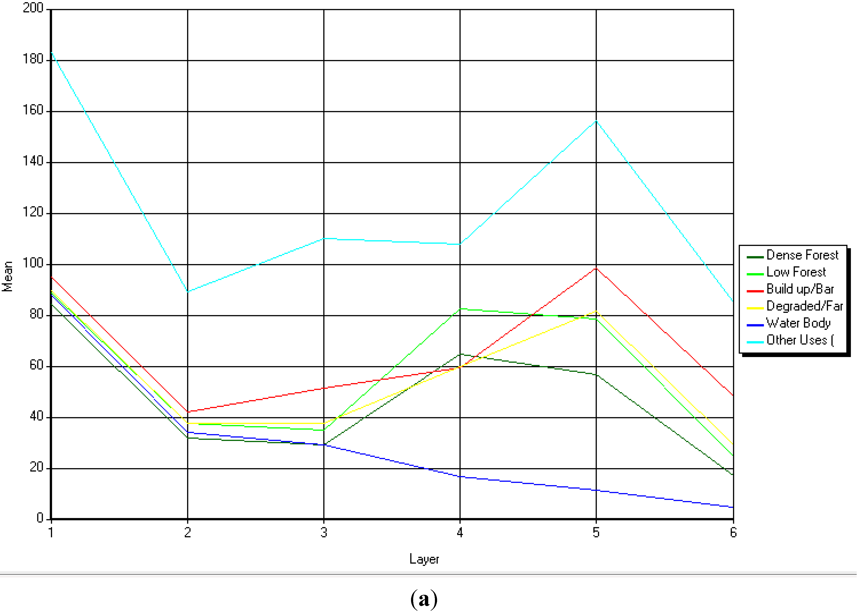
The signature mean plots (
Figure 1a) for the 1986 image yielded a Best Minimum Separability of the Jeffries-Matusita index of 1263.45. It shows that most of the land use classes were moderately separated in the bands, except the band 2, where almost all the classes coincided. This was expected to an extent, considering the level of reflectance characteristics of the images as per the surface configuration of the area at that time. Temporal degradation of the land during this time had exposed a greater percentage of the land to bare and open woodland and farm lands.
Figure 1.
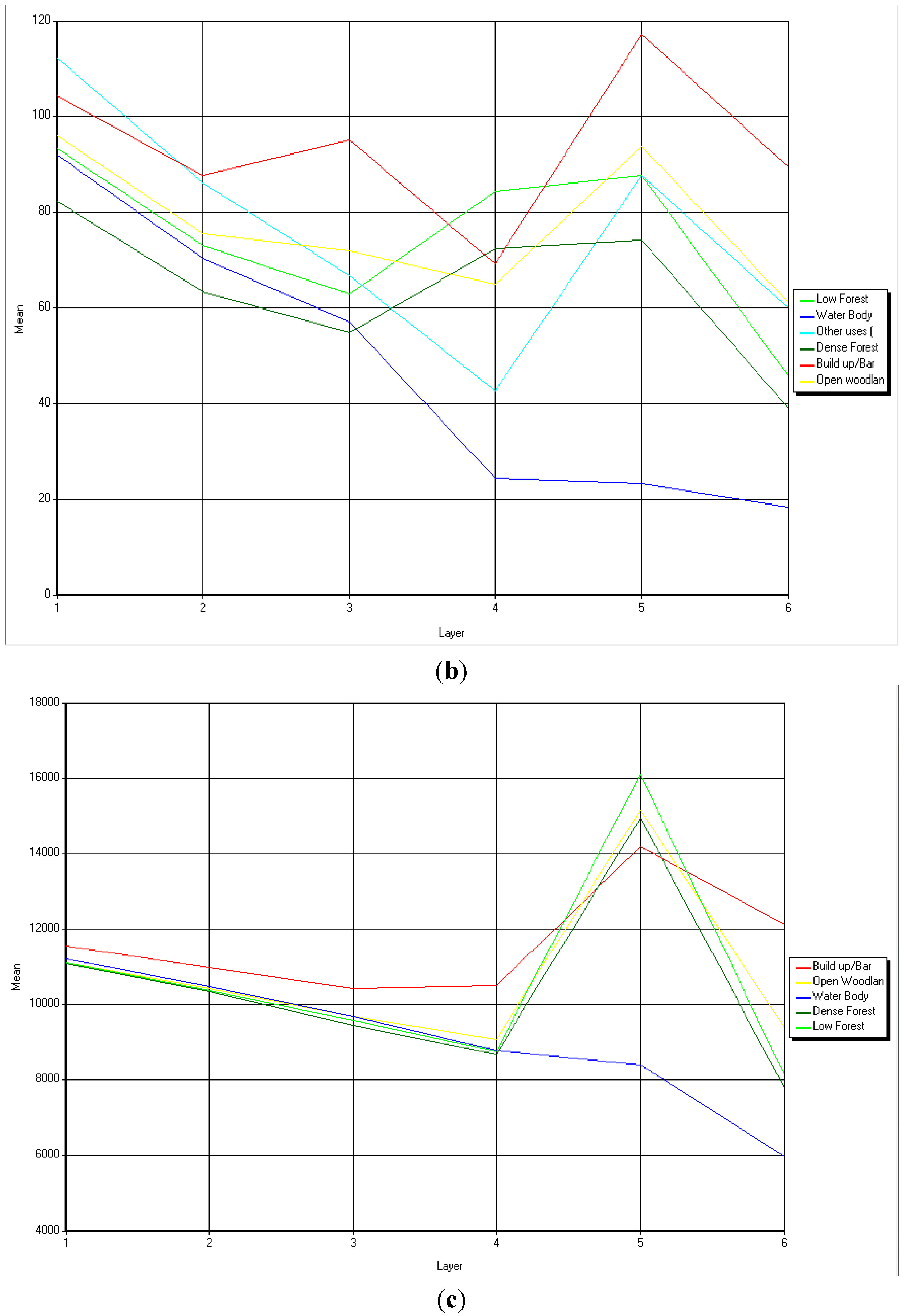
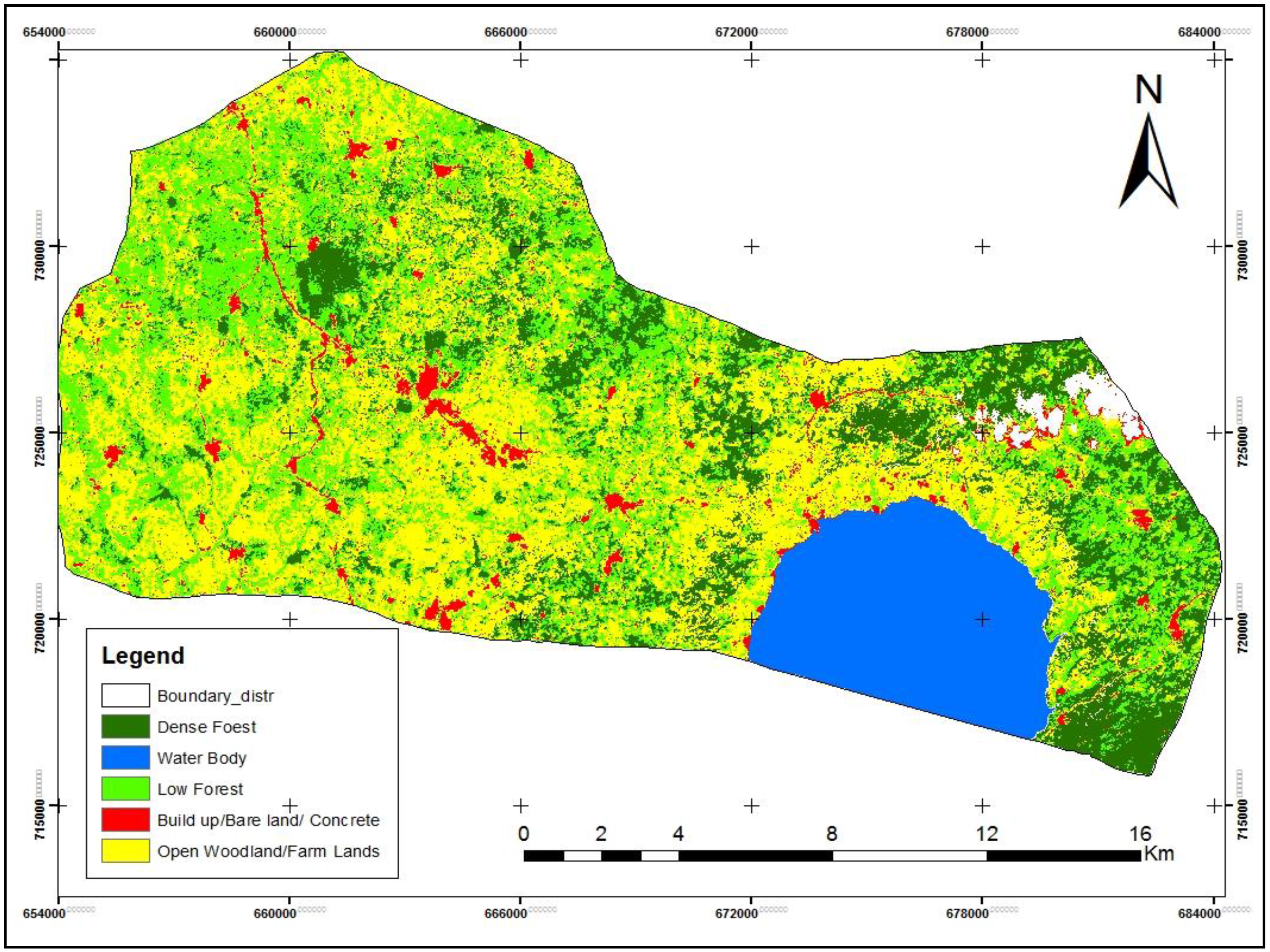
Spectoral Separability Plots for LULC Classes for (a) 1986 LULC; (b) 2010 LULC; (c) 2014 LULC.
Figure 1.
Spectoral Separability Plots for LULC Classes for (a) 1986 LULC; (b) 2010 LULC; (c) 2014 LULC.
Separability in the 2010 (
Figure 1b) image indicated a Best Minimum Separability of Jeffries-Matusita of 1287.51; thus, almost all the land use classes were from fairly separated to moderately separated. Especially in band 5, all the land use classes, with the exception of low forest and other uses as line stripes, separated well; this was especially so with the water body. In the same light, band 4 was also well separated. However, bands 1 and 2 did not show a better separability among the LULC types. This is an expected outcome since water reflects better in band 7. The signature plot (1c) for the 2014 image also shows that, with the exception of band 4, 5 and 6, which showed a moderate separability of the built up, low forest and water bodies, the rest of the land use classes were fairly separated by the remaining three bands. The Best Minimum Separability of Jeffries-Matusita index is 1072.25.
2.2. Classification Accuracy
In this study, because of the absence of the former land use maps and aerial photographs for the area, which would have been used as reference for accuracy checks, field observations were made and GPS points measured and recorded. This was used to aid in the assessment of the overall Kappa and individual class accuracies for the producer and user accuracies. The Kappa statistic is generally accepted as a measure of classification accuracy for both the model as well as user of the model of classification [
24]. Kappa values are characterized as <0 as indicative of no agreements and 0–0.2 as slight, 0.2–0.41 as fair, 0.41–0.60 as moderate, 0.60–0.80 as substantial and 0.81–1.0 as almost perfect agreement [
24,
25]. The overall classification accuracy of the images yielded a
Kappa hat statistic of 80.70%, 72.41% and 82.76% for the 1986, 2010 and the 2014 images, respectively. This is an indication of classification accuracy of moderately substantial to almost perfect agreement (
Table 1).
The overall accuracies were very good with the user and producer accuracies also being considerably high for almost all the land use classes. This is an indication of an acceptable LULC classification accuracy for images for which there were no available ground truth data as well as aerial photographs nor a pre-existing land use land cover maps. The high to very high accuracy of classification for the three images, emphasize the precision of the LULC sampled points obtained via the Global Position System (GPS) survey. For the accuracy assessment of the 1986 image, the technique of land use persistency was used and juxtaposed with the current GPS points collected from current field work.
The only limiting factor in the check for LULC accuracies was the absence of reference maps or points, during the accuracy assessment process; this was however fixed by another approach. On the basis of the classification accuracy check for the 1986 image, owing to the absence of pre-existing land use maps or aerial photographs to be used as the base reference map, we resorted to the Google history for the date of 20th April 2003. From the image, we assume that land use/covers such as the lake and towns, as well as some farmland were constantly put to such use over several years’ events; therefore, these LULC types do not change position over time. Based on this assumption, we selected the land use and land cover points from the Lake Bosomtwe, and settlements such as Kuntenase the district capital, Abono, Esereso, Nkonwi, Amankwaadei and New Brodekwaano, which did not change over the time and their respective coordinates recorded.
Subsequently, other land use types such as the dense forest reserve, near Aputuogya and at the southeastern part of the Lake as well as some farmlands visible in the Google image were also selected and their coordinates recorded as well. In all, 57 land use and land cover points were picked for the five land use categories namely the dense Forest, Low Forest, Built up and concrete areas, Open wood and farmlands as well as the Lake (water body).
These ground control points (GCPs) were imported into the ERDAS Imagine software, to compare the signatures of the various land uses to compute the accuracy assessment. At the end of the computation, the percentage accuracy of the classification was considerably improved over the previous value to 80.70%. The overall Kappa accuracy was also 0.764; this is, by far, a more improved accuracy.
Table 1.
Classification contingency matrix for 1986, 2010 & 2014 images.
Table 1.
Classification contingency matrix for 1986, 2010 & 2014 images.
| | 1986 ERROR MATRIX | |
| LULC Class | DF | LF | BBC | OWLF | WB | Total |
| DF | 9 | 1 | 0 | 0 | 0 | 10 |
| LF | 1 | 6 | 0 | 0 | 0 | 7 |
| BBC | 0 | 0 | 10 | 1 | 0 | 11 |
| OWLF | 0 | 2 | 0 | 0 | 12 | 14 |
| WB | 0 | 0 | 0 | 0 | 9 | 9 |
| Total | 10 | 9 | 10 | 1 | 21 | 51 |
| | Reference Totals | Classified Totals | Number Correct | Producers Accuracy | Users Accuracy | Classification Accuracy |
| DF | 14 | 10 | 9 | 64.29% | 90.00% | |
| LF | 9 | 7 | 6 | 66.67% | 85.71% | 80.70% |
| BBC | 11 | 11 | 10 | 90.91% | 90.91% |
| OWLF | 13 | 14 | 12 | 92.31% | 85.71% |
| WB | 10 | 9 | 9 | 90.00% | 100.00% | |
| | 2010 ERROR MATRIX | |
| LULC Class | DF | LF | BBC | OWLF | WB | Total |
| DF | 1 | 0 | 0 | 0 | 0 | 1 |
| F | 2 | 2 | 2 | 6 | 0 | 12 |
| BBC | 1 | 0 | 31 | 0 | 0 | 32 |
| OWLF | 0 | 1 | 4 | 6 | 0 | 11 |
| WB | 0 | 0 | 0 | 0 | 2 | 2 |
| Total | 4 | 3 | 37 | 12 | 2 | 58 |
| | Reference Totals | Classified Totals | Number Correct | Producers Accuracy | Users Accuracy | Classification Accuracy |
| DF | 4 | 1 | 1 | 25.00% | 100.00% | |
| LF | 3 | 12 | 2 | 66.67% | 16.67% | 72.41% |
| BBC | 37 | 32 | 31 | 83.78% | 96.88% |
| OWLF | 12 | 11 | 6 | 50.00% | 54.55% |
| WB | 2 | 2 | 2 | 00.00% | 100.00% | |
| | 2014 ERROR MATRIX | |
| LULC Class | DF | LF | BBC | OWLF | WB | Total |
| DF | 2 | 0 | 0 | 0 | 0 | 2 |
| LF | 1 | 1 | 0 | 3 | 0 | 5 |
| BBC | 0 | 0 | 34 | 0 | 0 | 34 |
| OWLF | 1 | 2 | 3 | 9 | 0 | 15 |
| WB | 0 | 0 | 0 | 0 | 2 | 2 |
| Total | 4 | 3 | 37 | 12 | 2 | 58 |
| | 2014 ERROR MATRIX | |
| | Reference Totals | Classified Totals | Number Correct | Producers Accuracy | Users Accuracy | Classification Accuracy |
| DF | 4 | 2 | 2 | 50.00% | 100.00% | |
| LF | 3 | 5 | 1 | 33.33% | 20.00% | 82.76% |
| BBC | 37 | 34 | 34 | 91.89% | 100.00% |
| OWLF | 12 | 15 | 9 | 75.00% | 60.00% |
| WB | 2 | 2 | 2 | 100.00% | 100.00% | |
6. Discussions
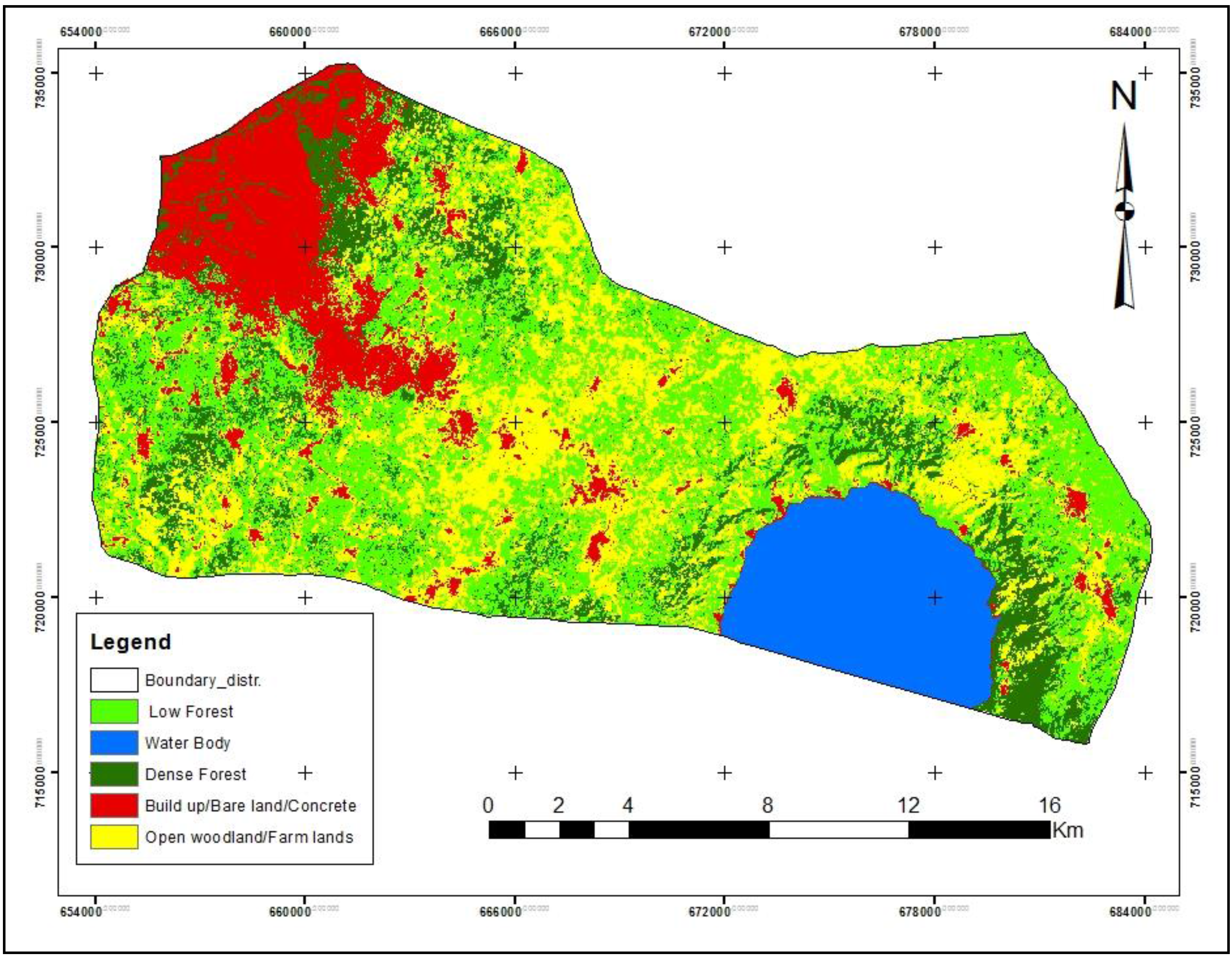
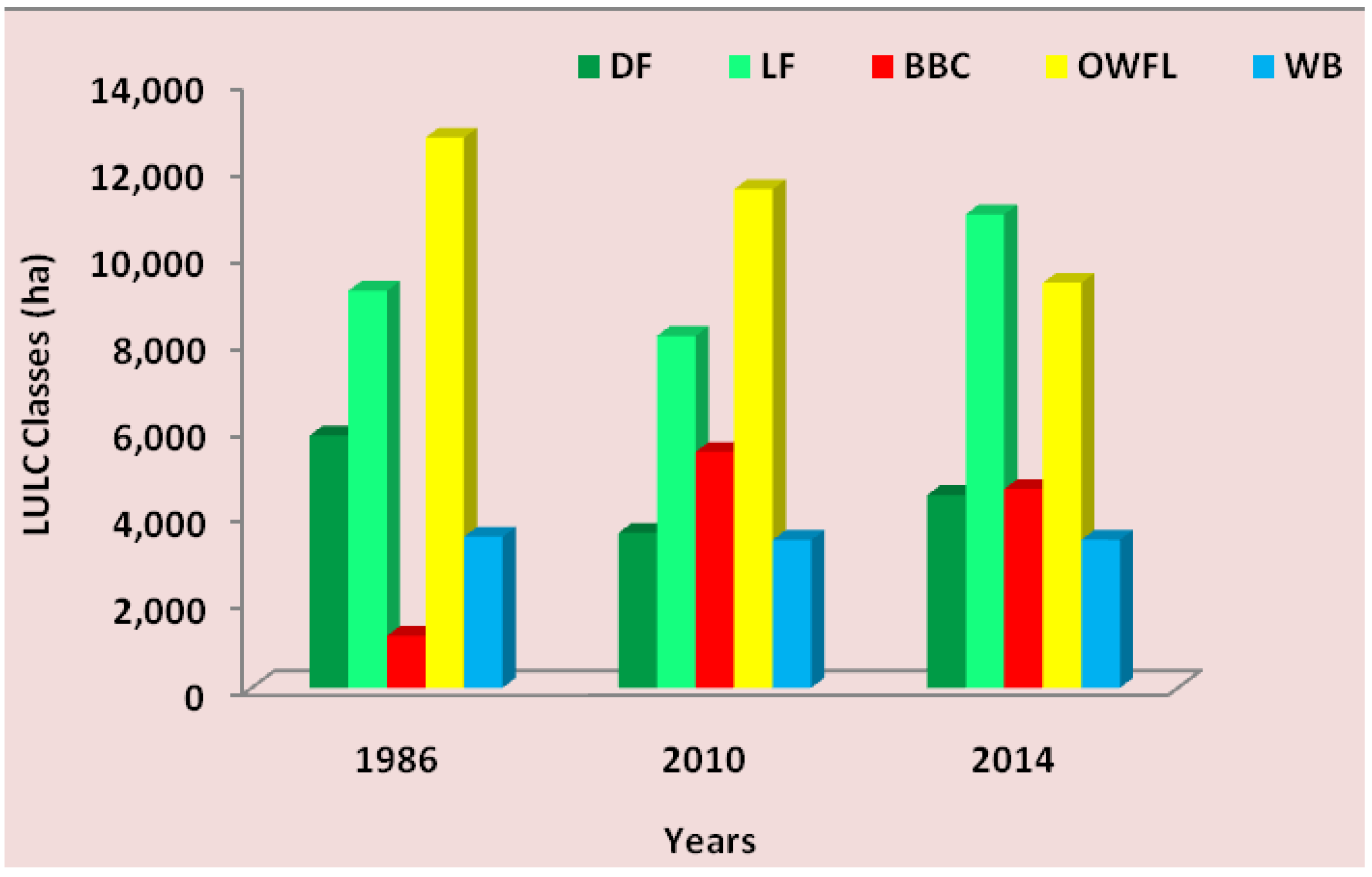
The seeming improvement in the vegetation cover was obtained from the open and bare land areas which were re-vegetated over the 24 year period. Explicitly, residential and commercial built up land uses were actually increasing. What presented the false impression was the composite built up-bare-concrete land use, part of which (bare areas) were covered in subsequent images. This trend of the LULC dynamic notwithstanding, there is a considerable reduction and transition from dense forest cover into low forest, which in itself also contains some human land use
i.e., plantation agriculture. Again the fact that open woodlands are increasing indicates that the level of agriculture based and other vegetation reduction based activities that emit carbon dioxide would continue to increase and consequently increase the local atmospheric greenhouse gas (GHG) loading [
21]. The increasing concentrations would have implications for “local warming” with variable impacts on the local climate, especially temperature and rainfall patterns.
The results obtained and analyzed, from the land use classes for the various years indicated that the district is experiencing appreciably rapid urbanization as the study conjectures and to a large extent corroborated by the socio-economic survey [
27]. Areas that exhibited peri-urban to urban land uses are concentrated mostly in the northwestern part of the district. Communities occupying this sub-section of the district include;
Esereso,
Sawua,
Jachie,
Pramso and
Aputuogya. The remaining communities in the district remain predominantly rural. The expansion rate in the growth of built up bare land and concrete surfaces area concurs with Acheampong and Anokye [
28] that population pressure and associated demand for residential accommodation are usually anticipated phenomena in peri-urban areas. The trending of this growth is seen in the typical “funnel-shaped” pattern from the main city centers towards the Bosomtwe District.
Clearly, land use and cover trends are largely inconsistent with increasing built up/bare land and concrete surfaces, as the classification results depict. In consonance with ground truth and population information, built up areas have increased to such an appreciable extent. This finding reinforces the general argument that areas of perceived urbanization tend to demonstrate rapid growth in residential and built up land uses [
29].The trends identified are characteristic of peri-urbanization to a possible urbanization.
Although the dense forest increased marginally in 2010, the low forest cover continued to increase considerably. In classifying the land uses and covers, some of the land use types were identified from ground truth. However, these were embedded in the low forest vegetation cover, with plantation farms of oil palm and some citrus fruits that dominate some areas in the district. This point to the fact that forest cover invariably loses quality in abundance whenever there is competition for the land use cover, in proportion to the other land uses, comparatively [
30]. Open woodland and farmlands are created during the clearing and burning of the vegetation, in preparation for cultivation. As far as forest cover as a sink to carbon dioxide is concerned, the enhanced emissions of anthropogenic sources could increase the carbon dioxide loads in the immediate local atmosphere [
31]. The consequences of these on local climate variability and change are imminent in the district.
The pointers show that land use in the district, though originally rural and agricultural, has been changing from the more agriculture and forest land uses (AFOLU) to peri-urban residential and commercial land uses, though at moderate rates of conversion. This is arguably an encouraging land use trend that needs to be promoted in order to reduce forest degradation and agriculture based greenhouse gasses emissions. The foregone analysis of the result shows that LULC transition in the district has been in the direction of built up/bare areas and concrete. There may be other extraneous factors responsible for this trend. This is because while low forest decreases in one year, there is a marginal transition from other land use classes into low and dense forest covers in subsequent years. This fluctuating trend in land use, however, is more in favour of built up bare and concrete areas, at the expense of forest land use and cover types over the entire periods under analysis. This situation according to Peng
et al [
32], is usually attributable to the rural land uses that change in response to the drivers of economic changes occurring as a result of modernization of the rural landscape and gradually replaced by the urban landscape characteristics.
7. Materials and Methods
7.1. Profile of the Study Area
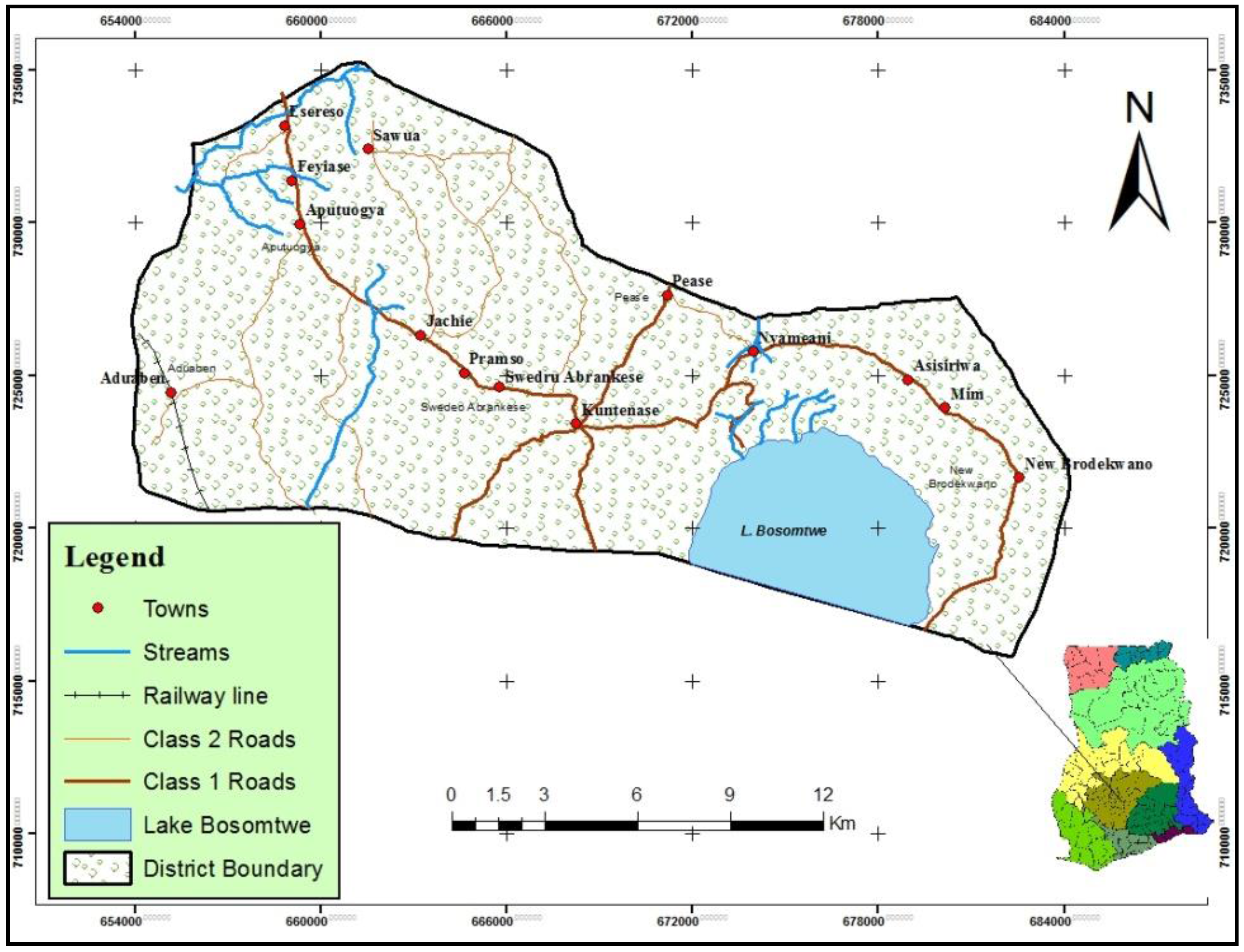
The Bosomtwe District is located in the central part of the Ashanti Region. It lies within Latitude 6°28′N–Latitude 6°40′N and Longitudes 1°2′W–Longitude 1°37′W.
Kuntenase is the District Capital. It spans over a land area of 330 km
2 (
Figure 6). The District is bounded to the North by
Atwima Nwabiagya and theKumasi Metropolis as well as to the East by
Ejisu-Juaben Municipal. The southern section is bounded by
Amansie West and East Districts, all in the Ashanti Region of Ghana.
Figure 6.
Map of the Bosomtwe District showing the study communities in Ghana.
Figure 6.
Map of the Bosomtwe District showing the study communities in Ghana.
Lake Bosomtwe, the largest natural (crater) lake in Ghana is located in the district. With the exception of the lake which has an outer ridge that maintains a constant distance of 10 km from the center of the lake and stands at an elevation of 500 to 1500 m, the rest of the district has other varying unique topographical features. The drainage pattern of rivers and streams draining the Bosomtwe District is dendritic and centripetal in outlook. Around Lake Bosomtwe, there is an internal drainage where the streams flow from surrounding highlands into the lake in a centripetal fashion. The streams form a dense network due to the double maxima rainfall regime. Notable rivers in the district are rivers Oda, Butu, Siso, Supan and Adanbanwe.
The district falls within the equatorial zone of climate with a rainfall regime typical of the moist semi-deciduous forest zone of the country. There are two well-defined rainfall seasons. The main season occurs from March to July and September to November with mean annual rainfall of about 1900 mm. The mean monthly temperature is about 36 °C with a relative humidity of between 60 and 85%.
The district falls within the Moist Semi-Deciduous Forest zone where different species of tropical hard woods with high economic value can be found. Species of trees found in the district include Wawa (Triplochiton scleroxylon), Mahogany (Khaya ivorensis), and Onyina (Ceiba pentandra) among others. In certain parts of the district, however, the original forest cover has been turned into secondary forest and grassland through indiscriminate exploitation of timber and inappropriate farming practices such as the slash and burn system and illegal gold mining activities.
The physical growth of settlements in the district is influenced by distance between the settlement and the Kumasi Metropolis. Further, the presence of infrastructure, socio-economic activities, the tourism sector improvements are all value additions to various land uses and cover. These make the district one of the potentially boisterous in the Ashanti Region.
7.2. Data and Software
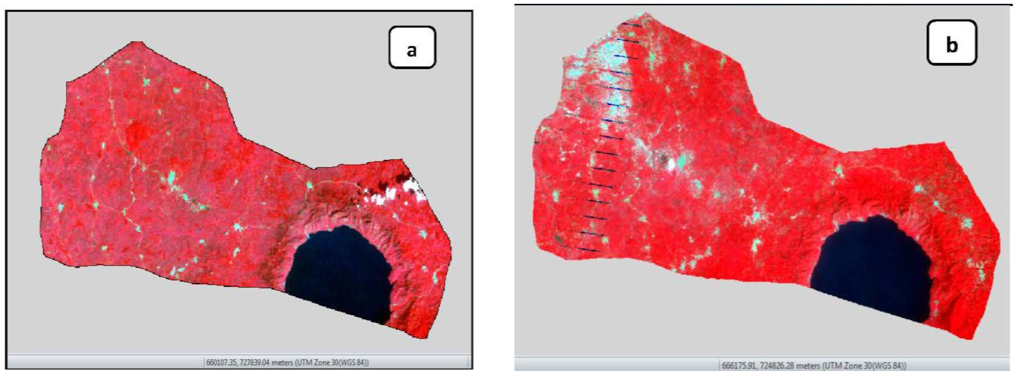
The classification and analysis of the various LULC classes were done using three Landsat satellite images covering the Landsat 5 TM for 1986 acquired on the 29
th December 1986, Landsat 7 ETM+ for 2010 acquired on 6
th February and Landsat 8 OLI/TIS for 2014 was acquired on the 8
th January, respectively (
Table 8 and
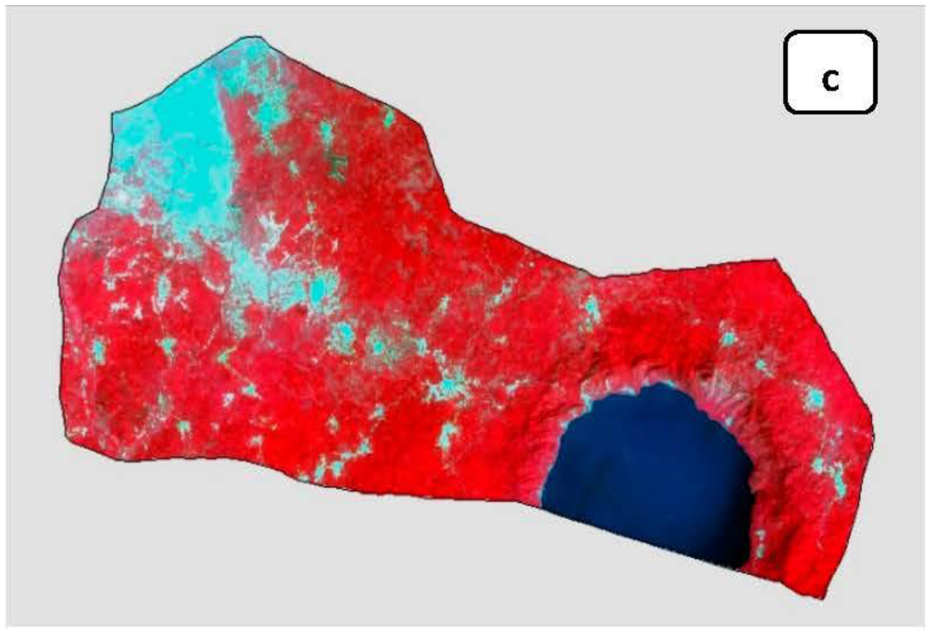
Figure 7 a–c). The choice for the selection of the three dates was influenced by the image quality in terms of those with limited or low cloud cover. The years with considerable evidence of vegetation regeneration after the 1980s forest fires due to prolonged drought conditions; and the need to ascertain the LULC trends over the 24 year period was considered long enough to generate adequate changes. The Garmin Global Position System (GPS) receiver was used to pick some 58 coordinates of selected land use land covers as ground control points from the field. The locations of these reference data were determined at random by identifying and locating the land use classes of interest in the field and their GPS points and coordinates picked and recorded. The instrument accuracy was determined at ±3m. The field surveys were conduction in early part of February 2013. The accuracy of the 1986 image was determined to form expert knowledge of the study district. The 2010 accuracy were determined using co-ordinate points of land uses obtained from the Google Earth image. The 2014 classification was assessed using the GPS points of selected land uses and land cover types collected in the field. These were used in the accuracy assessment procedure.
Figure 7.
The Landsat ETM/ETM+ Satellite Images for (a) 1986, (b) 2010 and OLI/TIS Image of (c) 2014 respectively, used in the classification of the LULC types.
Figure 7.
The Landsat ETM/ETM+ Satellite Images for (a) 1986, (b) 2010 and OLI/TIS Image of (c) 2014 respectively, used in the classification of the LULC types.
Table 8.
Satellite images characteristics.
Table 8.
Satellite images characteristics.
| Year | Satellite Sensor | Date Acquired | Spatial Resolution | Bands Used | Solar Elevation |
|---|
| 1986 | Landsat 5 TM | 1st of November | 30m × 30m | 1, 2, 3, 4, 5 & 7 | 45.06 |
| 2010 | Landsat 7 ETM+ | 6th of February | 30m × 30m | 1, 2, 3, 4, 5 & 7 | 2010 |
| 2014 | Landsat 8 OLI/TIS | 8th of January | 30m × 30m | 1, 2, 3, 4, 5 & 7 | 2014 |
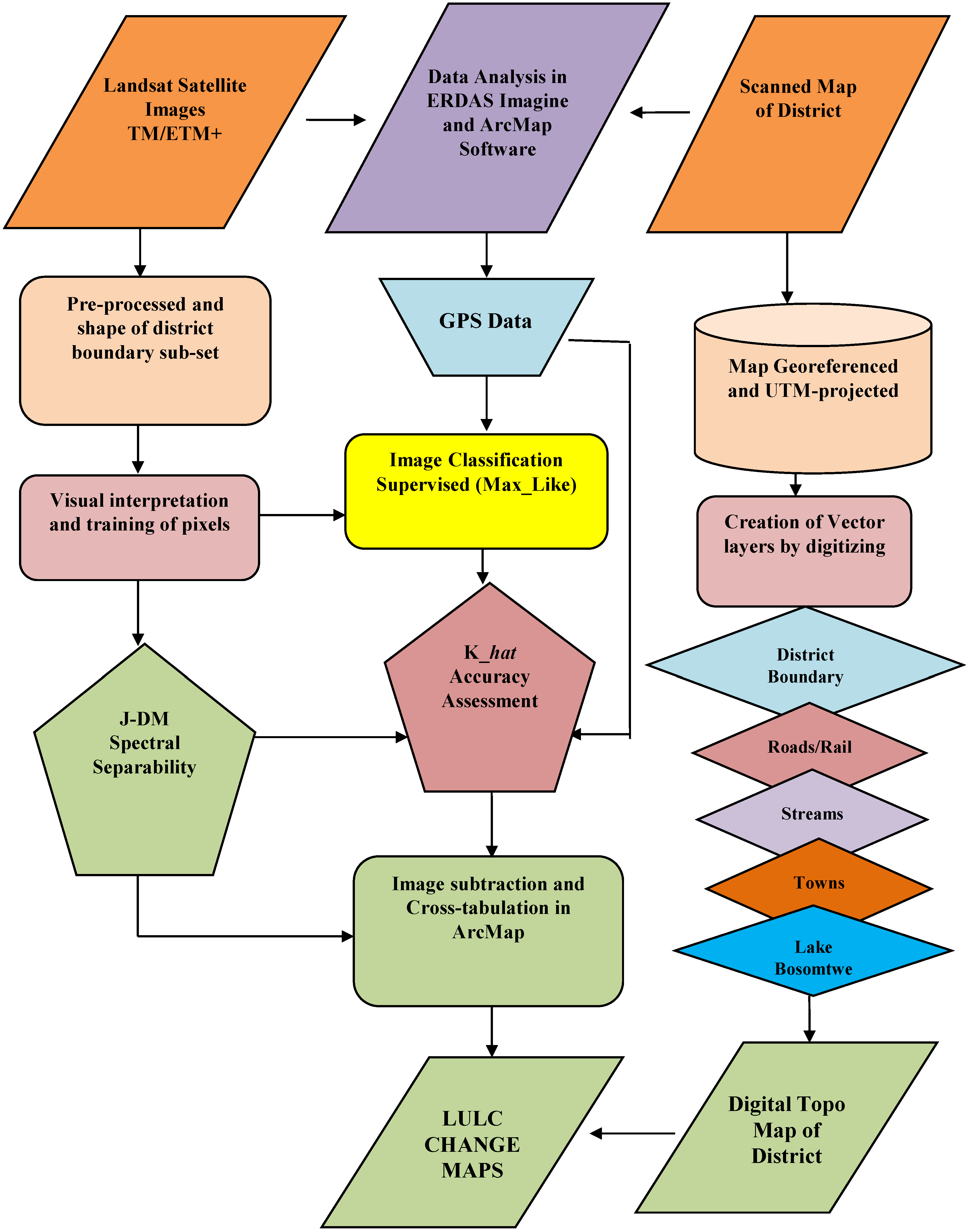
The image analytical software used and detailed in the methodological flow diagram, were
Hexagone Geospatial’s ERDAS Imagine13 and
ESRI’s ArcGIS v.10.1 (
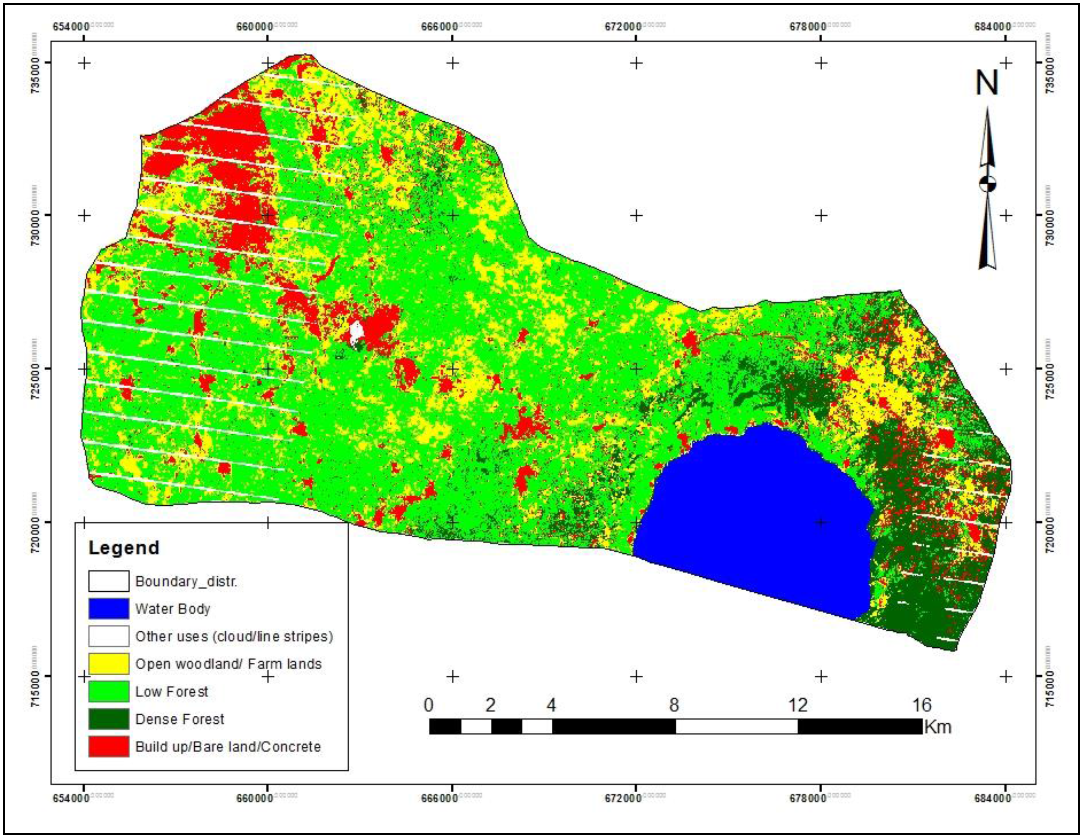
Figure 8). Based on the field experience and familiarity of the study area as well as the spectral characteristics of the images, the land use and cover classes identified were: Dense Forest cover (DF), Low Forest cover (LF), Built up/Bare lands and Concretes (BBC), Open Woodland and Farm lands (OWLF), Water Body (WB). Other phenomena such as cloud cover and line strips on the images were classified but were not used in the land use matrix analysis (
Table 9).
Table 9.
LULC classification scheme.
Table 9.
LULC classification scheme.
| LULC Classes | Descriptions of Land Use Land Cover Classes |
|---|
| Dense Forest (DF) | Deciduous and semi-deciduous forest tree cover with canopies typical of the tropical rainforest biome. Mostly restricted to the upper elevations of mountains ranges of the area including along the rims of Lake Bosomtwe. |
| Low Forest (LF) | Vegetative communities dominated by evergreen trees, with mean heights usually between 6 and 15 m. Also included in this class is the plantation agriculture such as oil palm and citrus. |
| Built Up/Bare Land/Concrete (BBC) | This is a land-use dominated by urban, peri-urban to rural settlements including bare, tarred and un-tarred roads as well as other concrete surfaces. |
| Open Woodlands/Farm Lands (OWFL) | Actively cultivated and fallow lands and prepared lands for cultivation. Vegetative communities dominated by perennial and annual grasses with occasional herbaceous species presence. |
| Water Body (WB) | The only water body classified is the Part of the lake Bosomtwe which falls in the study area. |
| Other Uses | These refer to the other uses identified as image noise such as cloud cover and shadows. |
Figure 8.
Methodological work flow in ERDAS Imagine and ArcGIS.
Figure 8.
Methodological work flow in ERDAS Imagine and ArcGIS.
7.3. Jeffries-Matusita Distance Separability and Accuracy Assessment
A spectral separability was also done to ascertain the degree of separation of each of the six (one, two, three, four, five and seven) bands from the other. This was also to appreciate the relative separability performance of each band according to the land use classes and to show the performance of the user in assigning certain pixel to a land use and land cover class. The separability criteria were assessed using
Jeffries-Matusita index and compared with the divergent index [
33]. In combination with the classification accuracy assessment, the quality of the results was checked. As reported in the appropriate sections, the results accuracy ranged from moderate to almost perfect agreement.
7.3.1. Spectral Separabilty
A spectral separability was done after classification, to ascertain the degree of separation of each of the six (one, two, three, four, five and seven) bands, from the other. This was also to appreciate the relative separability performance of each band according to the land use classes they reflected. This was to show the performance of the user in assigning certain pixel to a land use and land cover class. The separability criteria were assessed using Jefferies-Matusita and compared with the divergent indices [
34]. The separability listing also contains the average divergence and the minimum divergence for the band set. These numbers can be compared to other separability listing (for other band combinations), to determine which set of bands is the most useful for classification.
The
Jeffries-Matusita distance has upper and lower bounds (JM is between zero and 1414). If the calculated divergence is equal to the appropriate upper bound, then the signatures can be said to be totally separable in the bands being studied. A calculated divergence of zero means that the signatures are inseparable. That is, the
JM values that ERDAS Imagine reports are those resulting from multiplying the values in the formula times 1000. A separability listing is a report of the computed divergence for every class pair and one band combination (
Figure 1,
Figure 2,
Figure 3,
Figure 4 and
Figure 5).
7.3.2. Classification Accuracy Assessment
Classifying LULC maps from satellite images, require a quality check on the acceptability of the results of the classes that have been trained and assigned to each pixel in the image. The use of aerial photographs and previous LULC classes as well as the use of Global Position System (GPS) shows identified ground control points (GCPs), which are, in most instances land use types. The area of interest has invariably been used to corroborate the accuracy of LULC classification [
32]. In the absence of base maps and aerial photographs of the study area, GPS points of 58 LULC types were selected as ground controls points (GCPs) to ascertain the accuracy of the classification. This was done using the Kappa hat statistical analysis.
7.4. Image Classification and Change Detection
The LULC classes were assigned with the help of the classifier based on the user defined classification schema [
33]. This scheme was based on the visual interpretation of the images coupled with the user’s familiarity of the study area. In view of the relatively low spatial resolution of 30m × 30m, some of the classes have been combined for interpretation convenience. The scheme adopted is, described in
Table 9. This scheme formed the basis for the creation of the training areas which also contained the sampled LULC types from the field as GCPs in the image for the picking up of spectral signatures for the various LULC classes.
The classification algorithm used in the ERDAS Imagine software was supervised maximum likelihood classifier (MLC). Image differencing was performed in ArcGIS to ascertain the levels of change from one land use type to the other and by how much in terms of area in hectare. The rate of change (r) was calculated using the formula:
where,
A1,
A2, and
t are the LULC map of previous year, the current year and the time in years as duration between the two years respectively [
35].
7.5. Land Use Land Cover Change Transition
The analysis of the results from the image years between 1986 and 2002 and 2002 and 2007, LULC types were cross-tabulated for their transitional matrix shows that the land use classes transited from one type to another according some degree of proportions. Using the Markov transition matrix approach, we determined the transition rates from one land use type to another under certain intrinsic conditions. This was executed in ArcGIS cross-tabulation tool functionality.
This is because land use transitions follow rules that determine the change of a cell’s state during a subsequent iteration, according to Samat
et al. [
36]. These have cellular automata (CA) tendencies, which are based on the cell conversion probability, also called the likely rate of transition from one cell state (
i,
j) to another after a time
t. These five land use classes represent main land use activities in the district as per the classification. The transition of cells from time
t to
t+1 is determined by a function of its state, cell suitability and its transition probability rule.
This is given by equation below:
where,
t+1LUi,j = the potential of cell i,j to change at time t+1,
tLUi,j = current land use type of cell i,j at time t,
tSi,j = states of cell i,j at time t,
tPx,y,i,j = probability of cell i,j to change from state x to state y at time t+1.
The diagonals of the matrix, in
Table 4 and
Table 6, indicate, for instance, the land use types in area per hectare that was remained without any conversions of LULC class over the time period [
7,
37].
8. Conclusions and Recommendations
The LULC trends from 1986 through to the years 2010 and 2014 are consistently in favour of built up/bare land and concrete surfaces, as well as the open woodland and farmlands, to an appreciable extent. These trends are certainly the characteristics of peri-urbanization and a possible urbanization, consequently. This result largely implies that the Bosomtwe district is rapidly peri-urbanizing as the study conjectured, based on the earlier increasing urbanizing trend from the 1980s to the early 2000s.
In any case, the general observations from the field work, coupled with the classified images, show that plantation agriculture and food subsistent crop farming, dominate the landscape in terms of land use and cover in the District from 1986 to 2014. However, the pointers show that the land is put more to the use of residential and commercial purposes than agriculture and forest land uses (AFOLU).
In general terms, however, the probability of other land use types changing into other LULC types is highly in favour of built up and concrete land uses. According to the Markov chain transition reaction of proportions, the land use activities could lead to the general reduction in the vegetation cover in the district consequently over the next 24 years projected into the future. In comparing the vegetation and non-vegetation covers of the district, it can be observed that LULCs other than built up areas (which rapidly increased) are slightly increasing at the expense of forest covers. As low forest and dense forests reduce in size, particularly from 1986 to 2010, it is an indication of the reduction in agriculture and forest land use activities in the district. Conservation and protection of forest land use and cover are still imperative to ensure that forest based carbon emissions are controlled from unsustainable land use practices at the local scale [
38,
39].
The study findings have shown important changes in the land use and land cover patterns in the district. After an urbanization process, coupled with farmland abandonment between 1986 and 2010, substantial increments in peri-urban to urban land uses and clear increments in farmland coverage were found between 2010 and 2014. This suggests that major changes in the socio-ecological driving forces affecting landscape dynamics have occurred in the last two decades or so. In addition, this Landsat data-based study has provided insight into the dynamics of peri-urban landscapes, within the context of urban planning science.
