Improving the GIS-DRP Approach by Means of DelineatingRunoff Characteristics with New Discharge Relevant Parameters

Abstract
:1. Introduction & Aim
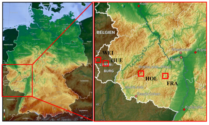
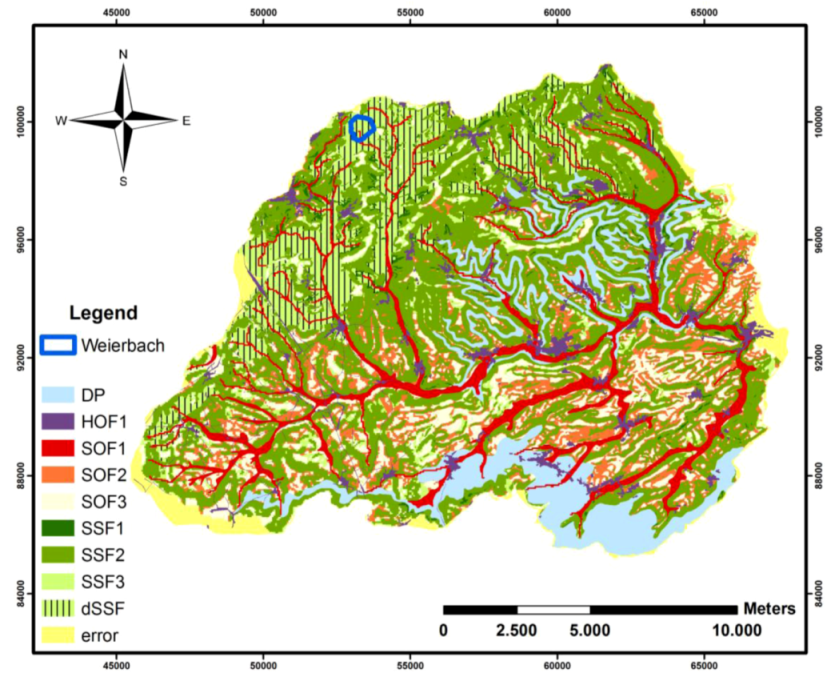
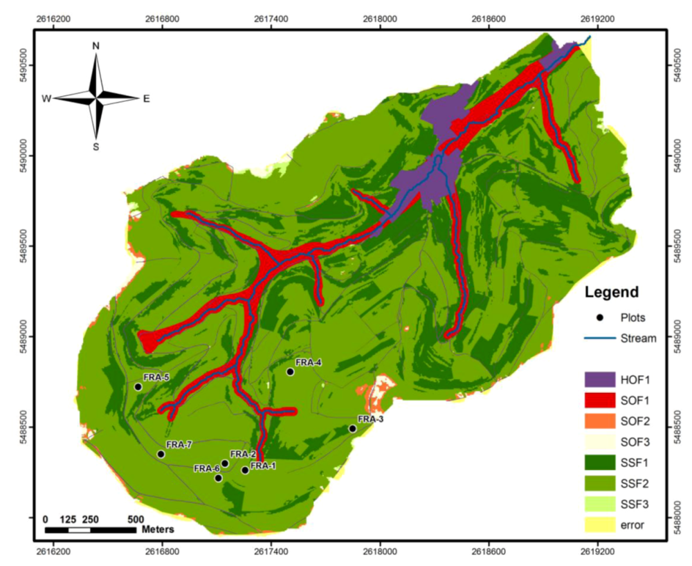
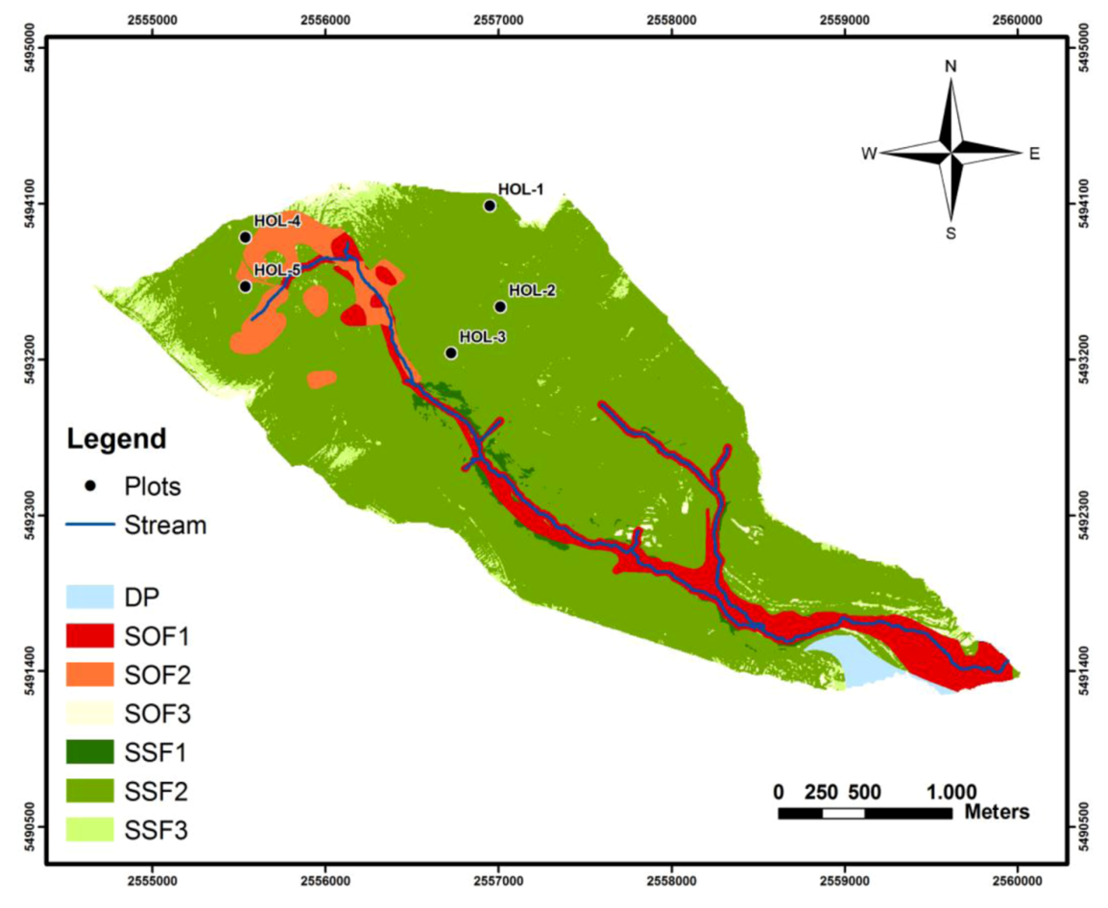
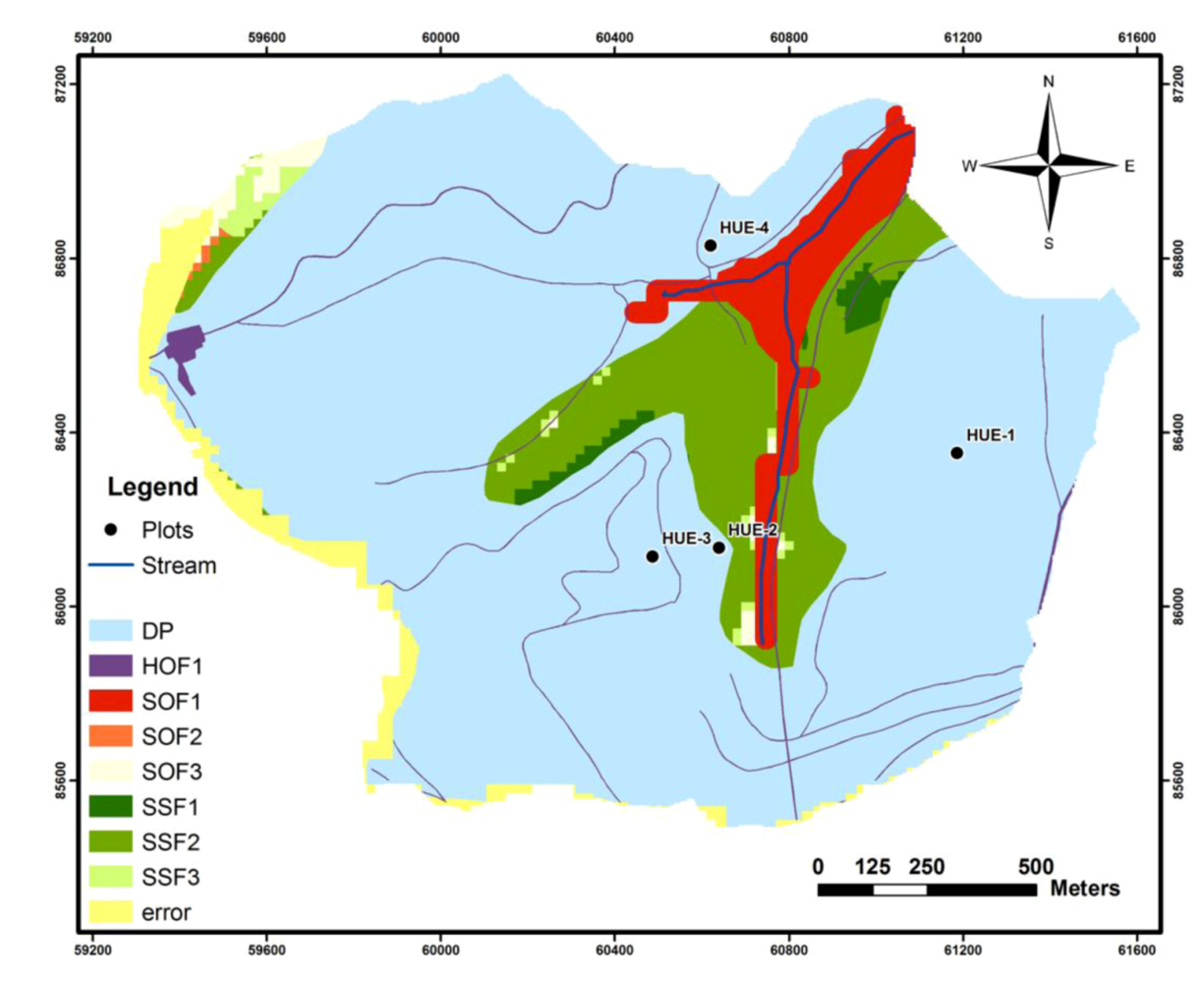
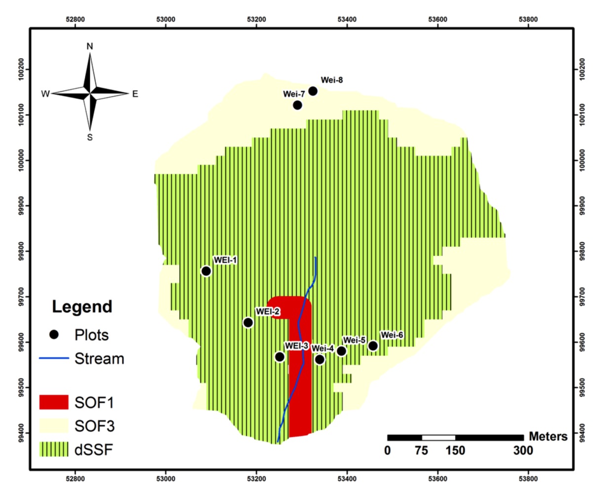
2. Study Area

| Frankelbach (FRA1-FRA7) | Holzbach (HOL1-HOL6) | Weierbach (WEI1-WEI8) | Huewelerbach (HUE1-HUE4) | |
|---|---|---|---|---|
| Geographic area | Saar-Nahe Bergland (RLP) | Hoch-Idarwald, Hunsrück (RLP) | Oesling (Luxembourg) | Gutland (Luxembourg) |
| Catchment area | 5 km2 | 4.2 km2 | 0.4 km2 | 2.7 km2 |
| Average elevation (AMSL) | 210–430 m | 400–650 m | 480–520 m | 300–400 m |
| Temperature (annual ) | 9 °C | 8 °C | 8 °C | 9 °C |
| Precipitation (annual) | 700–800 mm | 950–1,200 mm | 900–1,100 mm | 750–850 mm |
| Land use | 30% forest, 70% pasture/arable land | 100% forest | 100% forest | 91% forest, 7% pasture land, 2% settlement area |
| Parent material | Permian “Rotliegendes” New Red sediments | Devonian quartzite | Devonian schist “Sergean group” | Permian Sandstone and Marls |
| Dominant soil types | Haplic/Stagnic Cambisols | Haplic/Stagnic Cambisols and Podzols | Haplic Cambisols | Regosols, Haplic Cambisols, Podzols |
| Number of test plots | 7 | 6 | 8 | 4 |
3. Methods
3.1. DRP Approaches
Process Decision Schemes

GIS-DRP
| Slope | Impermeable | Impermeable | Permeable |
|---|---|---|---|
| (%) | Arable Land + Grassland | Forest | Arable Land + Grassland + Forest |
| 0–3 * | SOF 3 | SOF 3 | DP |
| >3–5 * | SOF 2 | SSF 3 | DP |
| >5–20 * | SSF 2 | SSF 2 | DP |
| >20–40 ** | SSF 1 | SSF 2 | DP |
| > 40 ** | SSF 1 | SSF 1 | DP |
- Short intensive rainfall in summer (>50% vegetation coverage)
- Long lasting extensive rainfall in summer (>50% vegetation coverage)
- Short intensive rainfall in winter (>50% vegetation coverage)
- Long lasting extensive rainfall in winter (>50% vegetation coverage)
- Long lasting extensive rainfall in winter (<50% vegetation coverage)
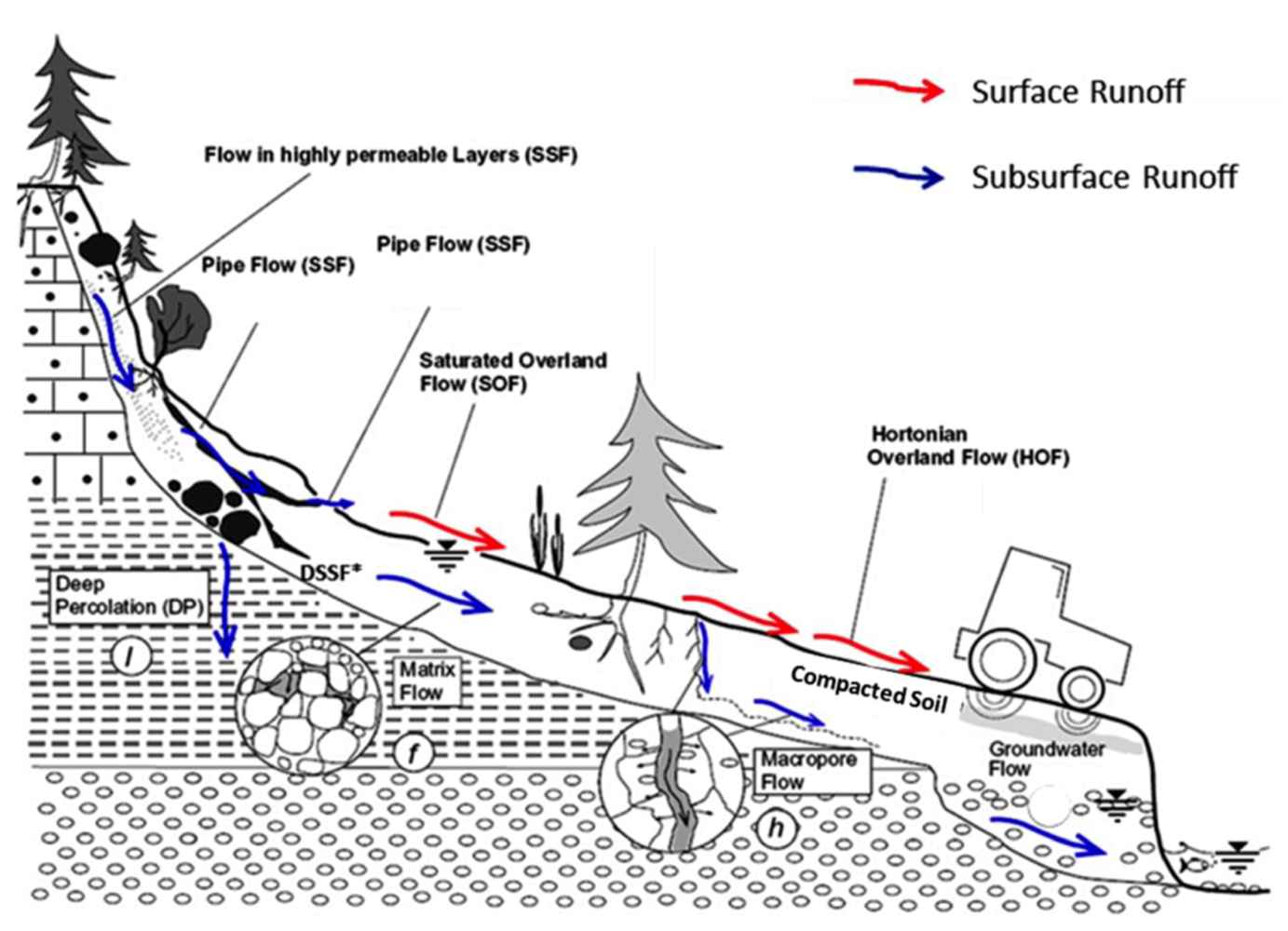
3.2. Soil-Hydrological Investigations
Soil Physical Investigations
Sprinkling Experiments at the Plot-Scale (50 m2)
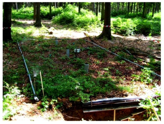
Sprinkling Experiments at the Point-Scale (0.28 m2)
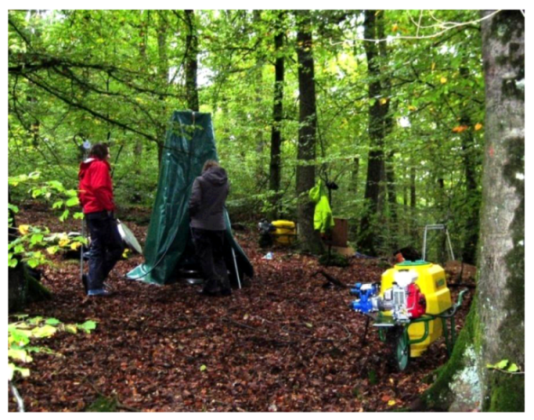
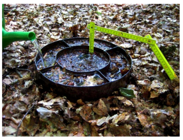
Infiltration Experiments
4. Results
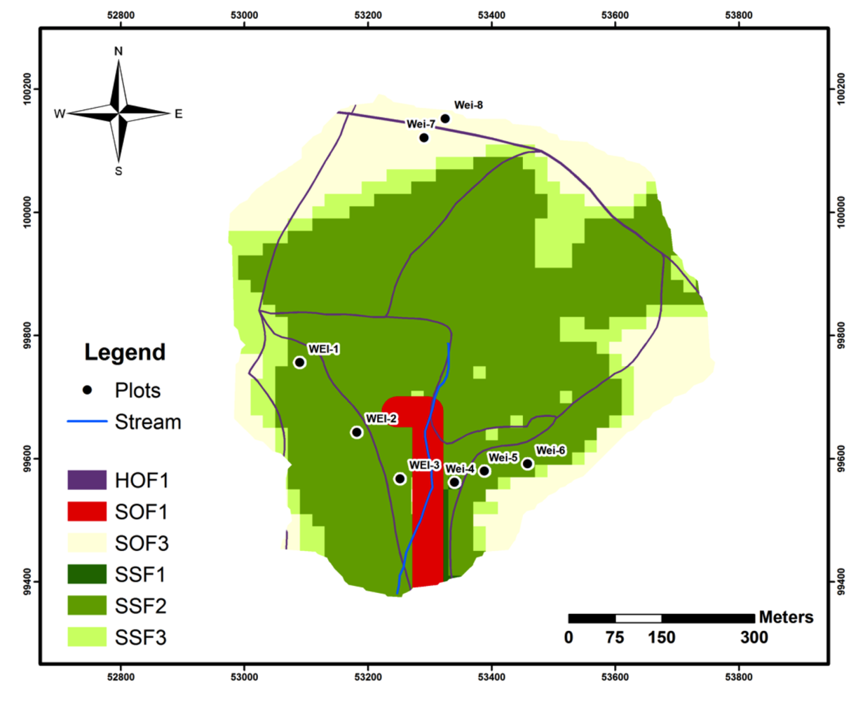
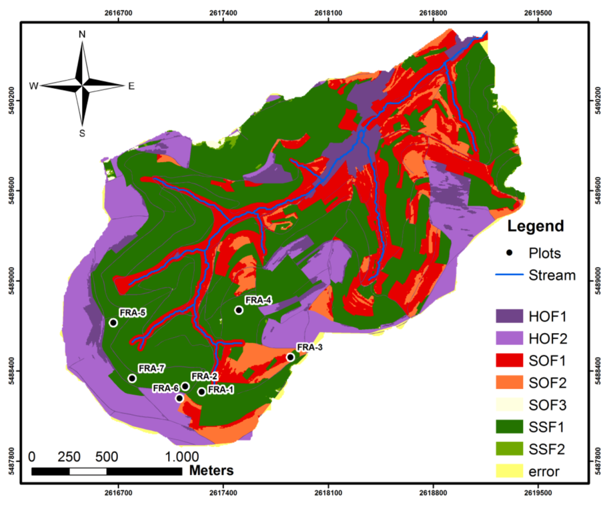
4.1. Application & Validation

| Plot | GIS-DRP | PBS (Scherrer) | DRP (Measurement) |
|---|---|---|---|
| FRA-1 | SSF 2 | SSF 2 | dSSF |
| FRA-2 | SSF 2 | SSF 2 | SSF 1/SOF 2 |
| FRA-3 | SSF 2 | SSF 2 | SSF 2 |
| FRA-4 | SSF 2 | SSF 2 | SSF 2/HOF 1 |
| FRA-5 | SSF 2 | SSF 2 | SSF 2 |
| FRA-6 | SSF 2 | HOF 2 | HOF 2 |
| FRA-7 | SSF 2 | SSF 2 | dSSF |
| HOL-1 | SSF 2 | SSF 3 | SSF 2 |
| HOL-2 | SSF 2 | SSF 3 | SSF 3 |
| HOL-3 | SSF 2 | SSF 2 | SSF 3 |
| HOL-4 | SSF 2 | SSF 2 | dSSF |
| HOL-5 | SSF 2 | SSF 2 | dSSF |
| HOL-6 | SSF 2 | SSF 2 | dSSF |
| WEI-1 | SSF 2 | SSF 2 | dSSF |
| WEI-2 | SSF 2 | SSF 2 | dSSF |
| WEI-3 | SSF 2 | SSF 2 | dSSF |
| WEI-4 | SSF 3 | SSF 3 | dSSF |
| WEI-5 | SSF 2 | SSF 2 | dSSF |
| WEI-6 | SSF 2 | SSF 2 | dSSF |
| WEI-7 | SOF 3 | SOF 3 | SOF 3 |
| WEI-8 | SOF 3 | SOF 3 | SOF 3 |
| HUE-1 | DP | DP | DP |
| HUE-2 | DP | DP | DP |
| HUE-3 | DP | DP | DP |
| HUE-4 | DP | DP | DP |
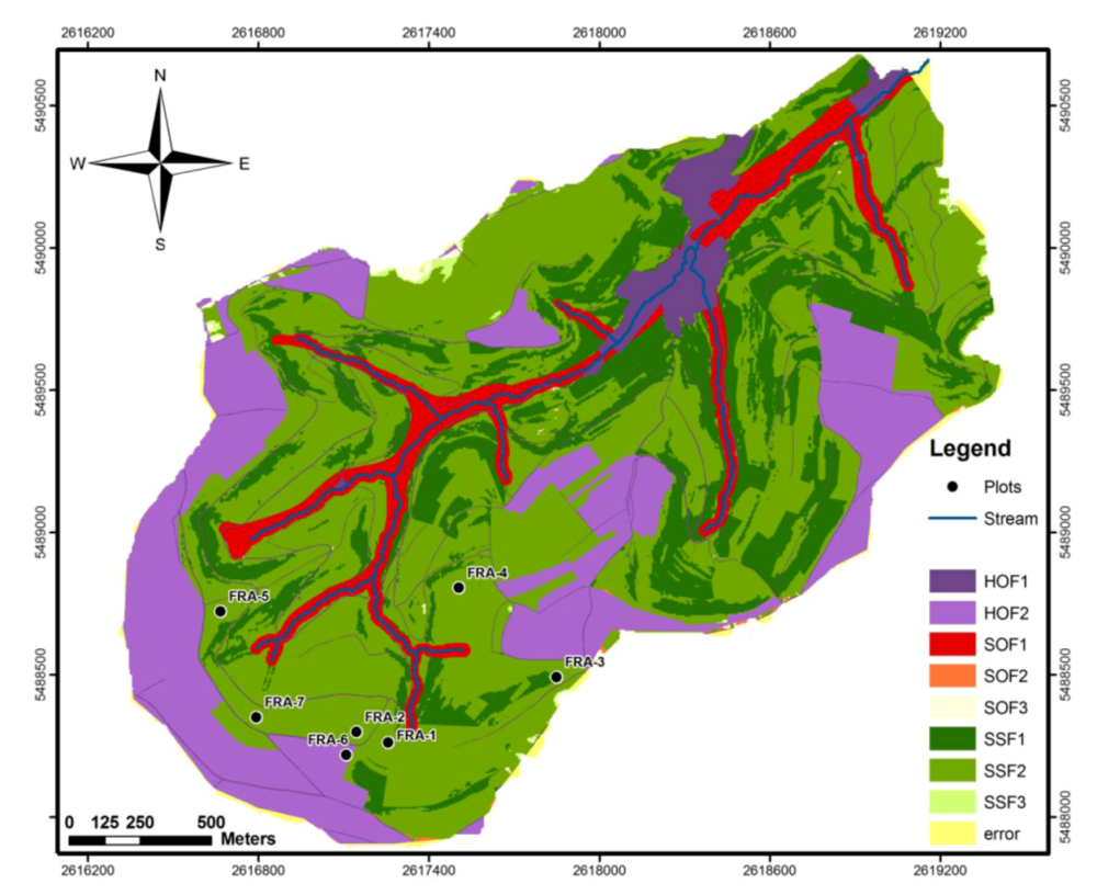
4.2. Improvements
- (i)
- Topsoil sealing;
- (ii)
- Extreme weather events and
- (iii)
- Semipermeability of the substratum (dSSF).
- (i)
- Topsoil sealing:The new table regarding topsoil sealing was predominantly changed for impermeable and permeable arable land (Table 4). Further minor modifications concern impermeable grassland and forests. This modification for topsoil sealing similarly encloses an adaption to the event classes. Consequently, the new characterization of DRP covers two so far not implemented classes:
- VI.
- Long lasting extensive rainfall in summer (<50% degree of coverage) and
- VII.
- Short intensive rainfall in winter (<50% degree of coverage).
- (ii)
- Extreme weather events:The results of the adaption of the GIS-DRP basic table regarding the parameter extreme events are listed in Table 5. Almost all DRP on every land use type and every slope became modified, except for forest stands with permeable substrata. Here, no change of characterization is necessary because even in extreme weather events, forests with a highly permeable soil and bedrock tend to produce predominantly deep percolation (DP). In case of grassland usage, mainly saturated overland flow processes (SOF) became classified due to results of field studies accomplished by Hümann et al. [15]. Moreover, SOF 2 and SOF 1 were chosen to establish a differentiation between the fast reacting Hortonian overland flow processes (HOF) on urban areas like streets or sealed topsoil surfaces and the slightly delayed SOF processes on grassland. Here, it has to be mentioned that a specific uncertainty remains due to variable surface characteristics on grassland areas (e.g., intensive or extensive grazing; fellow grassland; mowing meadow etc.). These variable surface characteristics cannot definitely be distinguished by the used basic data within the GIS-DRP approach. Thus, the resulting dominant runoff processes on grassland (SOF 1 and SOF 2) during extreme weather events should be seen as an approximation to the actual occurring processes. Nevertheless, with this new classification of dominant runoff processes it was possible to also cover the eighth event class:
- VIII.
- Short intensive rainfall in summer (<50% degree of coverage).
Table 4. GIS-DRP table topsoil sealing. Slope Impermeable Impermeable Impermeable Permeable Permeable (%) Arable Land Grassland Forest Arable Land Grassland + Forest 0–3 HOF 2 SOF 2 SOF 3 HOF 2 DP 3–5 HOF 2 SOF 2 SSF 3 HOF 2 DP 5–20 HOF 2 SSF 1 SSF 2 HOF 2 DP 20–40 HOF 2 SSF 1 SSF 1 HOF 2 DP >40 HOF 2 SSF 1 SSF 1 HOF 2 DP Table 5. GIS-DRP table extreme events. Slope Impermeable Impermeable Impermeable Permeable Permeable Permeable (%) Arable Land Grassland Forest Arable Land Grassland Forest 0–3 HOF 2 SOF 2 SOF 2 HOF 2 SOF 2 DP 3–5 HOF 2 SOF 2 SSF 2 HOF 2 SOF 2 DP 5–20 HOF 2 SOF 2 SSF 1 HOF 2 SOF 2 DP 20–40 HOF 1 SOF 1 SSF 1 HOF 1 SOF 1 DP >40 HOF 1 SOF 1 SSF 1 HOF 1 SOF 1 DP
Accordingly, the five so far enclosed event classes within GIS-DRP (mentioned in Section 3.2) can be classified as relatively low in intensity. Therefore, these rainfall varieties together represent the rainfall intensity class of basic events.Event classes VI and VII—introduced with the adaption to topsoil sealing—form the rainfall intensity class of medium events.The event class VIII represents very high precipitation intensities. Hence, this combination of rainfall type, season and degree of coverage characterizes the rainfall intensity class of extreme events. - (iii)
- Semipermeability:The parameter semipermeability, which reflects the soil and bedrock characteristics and its permeability for water, is a basic requirement for the generation of deep subsurface flow (dSSF). Since dSSF was determined only on forested plots, this runoff process is associated with forest usage in the modified GIS-DRP table (Table 6).
Table 6. GIS-DRP table semipermeability. Slope Impermeable Impermeable Semipermeable Permeable (%) Arable Land + Grassland Forest Forest Arable Land + Grassland + Forest 0–3 SOF 3 SOF 3 SOF 3 DP 3–5 SOF 2 SSF 3 dSSF DP 5–20 SSF 2 SSF 2 dSSF DP 20–40 SSF 1 SSF 2 dSSF DP >40 SSF 1 SSF 1 dSSF DP
5. Discussion
5.1. Topsoil Sealing
5.2. Extreme Event

5.3. Semipermeability

6. Conclusion
Acknowledgments
References
- Grigoryan, G.V.; Casper, M.C.; Gauer, J.; Vasconcelos, A.C.; Reiter, P.P. Impact of climate change on water balance of forest sites in Rhineland-Palatinate, Germany. Adv. Geosci. 2010, 27, 37–43. [Google Scholar] [CrossRef]
- Casper, M.C.; Grigoryan, G.; Gronz, O.; Gutjahr, O.; Heinemann, G.; Ley, R.; Rock, A. Analysis of projected hydrological behavior of catchments based on signature indices. Hydrol. Earth Syst. Sci. 2012, 16, 409–421. [Google Scholar] [CrossRef]
- Intergovernmental Panel on Climate Change IpccKlimaänderung 2007—Zusammenfassungen für politische Entscheidungsträger; Deutsche ÜbersetzungDeutsche IPCC-Koordinierungsstelle: Stuttgart, German, 2007.
- Hellebrand, H.; Müller, C.; Fenicia, F.; Matgen, P.; Savenije, H. A process proof test for model concepts: modelling the meso-scale. Phys. Chem. Earth 2011, 36, 42–53. [Google Scholar]
- Scherrer, S. Bestimmungsschlüssel zur Identifikation von Hochwasserrelevanten Flächen; Bericht 18; State Office for Water Economy Rhineland-Palatinate: Mainz, Germany, 2006; pp. 1–126. [Google Scholar]
- Schüler, G. Identification of flood-generating forest areas and forestry measures forwater retention. For. Snow Landscape Res. 2006, 80, 99–114. [Google Scholar]
- Peschke, G.; Etzenberg, C.; Müller, G.; Töpfer, J.; Zimmermann, S. Das Wissensbasierte System FLAB—Ein Instrument zur rechnergestützten Bestimmung von Landschaftseinheiten mit gleicher Abflussbildung. IHI-Schriften 1999, 10, 122. [Google Scholar]
- Scherrer, S.; Naef, F. A decision scheme to identify dominant flow processes at the plot scale for the evaluation of contributing areas at the catchments-scale. Hydrol. Process. 2003, 17, 391–401. [Google Scholar] [CrossRef]
- Scherrer, S.; Naef, F. A Decision Scheme to Identify Dominant Flow Processes at the Plot Scale for the Evaluation of Contributing Areas at the Catchments-Scale. In Runoff Generation and Implivations for River Basin Modelling; Leibundgut, C., Uhlenbrook, S., McDonnell, J., Eds.; Selbstverlag des Institutes für Hydrologie der Universität Freiburg: Freiburg, Germany, 2003; Volume 13, pp. 11–16. [Google Scholar]
- Schmocker-Fackel, P.; Naef, F.; Scherrer, S. Identifying runoff processes on the plot and catchment scale. Hydrol. Earth Syst. Sci. 2007, 11, 891–906. [Google Scholar] [CrossRef]
- Schobel, S. Erläuterungsbericht zur Abflussprozesskarte der Einzugsgebiete des Grundsgrabens und Schleidweiler Baches bei Gemeinde Zemmer/Eifel; Bericht Forschungsanstalt für Waldökologie und Forstwirtschaft Rheinland-Pfalz: Trippstadt, Germany, 2005; p. 76. [Google Scholar]
- Tilch, N.; Uhlenbrook, S.; Leibundgut, C. Regionalisierungsverfahren zur Ausweisung von Hydrotopen in von periglazialem Hangschutt geprägten Gebieten. Grundwasser 2002, 7, 206–216. [Google Scholar]
- Tilch, N.; Zillgens, B.; Uhlenbrook, S.; Leibundgut, Ch.; Kirnbauer, R.; Merz, B. GIS-gestützte Ausweisung von hydrologischen Umsatzräumen und Prozessen im Löhnersbach-Einzugsgebiet (Nördliche Grauwackenzone, Salzburger Land). Österreichische Wasser- und Abfallwirtschaft 2006, 58, 141–151. [Google Scholar] [CrossRef]
- Müller, C.; Hellebrand, H.; Seeger, M.; Schobel, S. Identification and regionalization of dominant runoff processes—A GIS-based and a statistical approach. Hydrol. Earth Syst. Sci. 2009, 13, 779–792. [Google Scholar] [CrossRef]
- Hümann, M.; Schüler, G.; Müller, C.; Schneider, R.; Johst, M.; Caspari, T. Identification of runoff processes—Impact of different forest types and soil properties on soil-water interrelations and floods. J. Hydrol. 2011, 409, 637–649. [Google Scholar] [CrossRef]
- Sauer, T. Modellierung von Bodenwasserhaushalt und Abflussprozessen auf der Plotskale in Abhängigkeit von Substrat und Landnutzung. Ph.D. Thesis, Universität Trier, Trier, Germany, 2009; p. 269. [Google Scholar]
- Stahr, K. Die Bedeutung periglazialer Deckschichten für Bodenbildung und standortseigenschaften im Südschwarzwald. Freiburger Bodenkundliche Abhandlungen 1979, 9, 233. [Google Scholar]
- Voelkel, J.; Zepp, H.; Kleber, A. Periglaziale deckschichten in mittelgebirgen—Ein offenes forschungsfeld. Berichte zur deutschen Landeskunde 2002, 76, 101–114. [Google Scholar]
- Hellebrand, H. Theories, Experiments, Tools—An Applied Hydrologigal Spatio-Temporal Assessment of Meso-Scale Basins with a View to Regionalization. Ph.D. Thesis, TU Delft, Delft, The Netherlands, 2010. [Google Scholar]
- Scherrer, S.; Demuth, N. Die Identifikation von Hochwasserrelevanten Flächen als Grundlage für die Beurteilung von Extremen Abflüssen. In Dezentraler Wasserrückhalt in der Landschaft durch vorbeugende Maßnahmen der Waldwirtschaft, der Landwirtschaft und im Siedlungswesen, Mitteilungen der FAWF; Schüler, G., Gellweiler, I., Seeling, S., Eds.; Forschungsanstalt für Waldökologie und Forstwirtschaft, 64/07: Trippstadt, Germany, 2007; pp. 175–182. [Google Scholar]
- Zumstein, J.F.; Gille, E.; Deloux, J.P.; Paris, P. Atlas de la Lithologie et de la Perméabilité du Bassin Rhin-Meuse; Agence de l’eau Rhin-Meuse: Moulin-lès-Metz, France, 1989. [Google Scholar]
- Müller, C. Hochwasserschutz in der Landwirtschaft—Validierung und Modellierung Ausgewählter Maßnahmen. In Trierer Bodenkundliche Schriften; Emmerling, C., Ed.; Universität Trier: Trier, Germany, 2010; Volume Band 15, p. 219. [Google Scholar]
- Schobel, S. Infiltrations- und Bodenabflussprozesse in Abhängigkeit von Landnutzung und Substrat in der Trier-Bitburger Mulde. Ph.D. Thesis, Universität Trier, Trier, Germany, 2008. [Google Scholar]
- Karl, J.; Toldrian, H. Eine transportable Beregnungsanlage für die Messung von Oberflächenabfluss und Bodenabtrag. Wasser und Boden 1973, 25, 63–65. [Google Scholar]
- State Office for Water Economy Rhineland-Palatinate, Hochwasser im Rheineinzugsgebiet—März 2001; LFW-BERICHT NR. 204/01; Landesamt für Wasserwirtschaft: Mainz, Germany, 2001.
- Calvo, A.; Gisbert, J.M.; Palau, E.; Romero, M. Un simulador de Lluvia Portátil de Fácil Construcción. In Métodos y Técnicas Para la Medición en el Campo de Procesos Geomorfológicos; Sala, M., Gallart, F., Eds.; Sociedad Española de Geomorfología: Barcelona, Spain, 1988; pp. 6–15. [Google Scholar]
- Lasanta, T.; Perez Rontome, M.C.; Garcia-Ruiz, J.M. Efectos Hidromorfológicos de Differentes Alternativas de Retirada de Tierras en Ambientes Semiáridos de la Depresión del Ebro. In Efectos Geomorfológicos del Abandono de Tierras; Lasanta, T., Garcia-Ruiz, J.M., Eds.; SEG: Zaragoza, Spain, 1994; pp. 69–82. [Google Scholar]
- Iserloh, T.; Fister, W.; Ries, J.B.; Seeger, M. Design and Calibration of the Small Portable Rainfall Simulator of Trier University. In Proceedings of EGU General Assembly 2010, Vienna, Austria, 2–7 May 2010; p. 2769.
- Wohlrab, B.; Ernsberger, H.; Meuser, A.; Sokollek, V. Landschaftswasserhaushalt. Wasserkreislauf und Gewässer im ländlichen Raum. Veränderungen durch Bodennutzung, Wasserbau und Kulturtechnik; Verlag Paul Parey: Hamburg und Berlin, Germany, 1992. [Google Scholar]
- Tromp-van Meerveld, H.J.; McDonnell, J.J. Threshold relations in subsurface stormflow: 2. The fill and spill hypothesis. Water Resour. Res. 2006. [Google Scholar] [CrossRef]
- Schröder, R. Modellierung von Verschlämmung und Infiltration in landwirtschaftlich genutzten Einzugsgebieten; Asgard-Verlag: Sankt Augustin, Germany, 2000. [Google Scholar]
- FAO, Soil Tillage in Africa: Needs and Challenges; FAO Soils Bulletin 69; Soil Resources, Management and Conservation Service Land and Water Development Division: Rome, Italy, 1993.
- Schmidt, W.; Zimmerling, B.; Nitzsche, O.; Krück, S.T. Conservation tillage—A new strategy in flood control. NATO Sci. Ser. 2001, 6, 287–293. [Google Scholar]
- Markart, G.; Kohl, B.; Sotier, B.; Schauer, T.; Bunza, G.; Stern, R. Provisorische Geländeanleitung zur Abschätzung des Oberflächenbeiwertes auf alpinen Boden-/Vegetationseinheiten bei konvektiven Starkregen; BFW-Dokumentation; Bundesamt und Forschungszentrum für Wald: Wien, Österreich, 2004. [Google Scholar]
- Sokollek, V. Untersuchungen über den Einfluß der Landnutzung auf den Oberflächenabfluss; Jahresbericht der ökologischen Forschungsstation Justus-Liebig-Universität Gießen: Gießen, Germany, 1977. [Google Scholar]
- Johst, M. Experimentelle und Modellgestützte Untersuchungen zur Hochwasserentstehung im Nordpfälzer Bergland unter Verwendung Eines Neuartigen Spatial-TDR-Bodenfeuchtemessgeräts. Ph.D. Thesis, Universität Trier, Trier, Germany, 2011. [Google Scholar]
- Juilleret, J.; Iffly, J.F.; Hoffmann, L.; Hissler, C. The potential of soil survey as a tool for surface geological mapping: A case study in a hydrological experimental catchment (Huewelerbach, Grand-Duchy of Luxembourg). Geologica Belgica 2012, 15, 36–41. [Google Scholar]
- Chifflard, P.; Didszun, J.; Zepp, H. Skalenübergreifende prozess-studien zur abflussbildung in gebieten mit periglazialen deckschichten (Sauerland, Deutschland). Grundwasser 2008, 13, 27–41. [Google Scholar] [CrossRef]
© 2013 by the authors; licensee MDPI, Basel, Switzerland. This article is an open access article distributed under the terms and conditions of the Creative Commons Attribution license (http://creativecommons.org/licenses/by/3.0/).
Share and Cite
Hümann, M.; Müller, C. Improving the GIS-DRP Approach by Means of DelineatingRunoff Characteristics with New Discharge Relevant Parameters. ISPRS Int. J. Geo-Inf. 2013, 2, 27-49. https://doi.org/10.3390/ijgi2010027
Hümann M, Müller C. Improving the GIS-DRP Approach by Means of DelineatingRunoff Characteristics with New Discharge Relevant Parameters. ISPRS International Journal of Geo-Information. 2013; 2(1):27-49. https://doi.org/10.3390/ijgi2010027
Chicago/Turabian StyleHümann, Marco, and Christoph Müller. 2013. "Improving the GIS-DRP Approach by Means of DelineatingRunoff Characteristics with New Discharge Relevant Parameters" ISPRS International Journal of Geo-Information 2, no. 1: 27-49. https://doi.org/10.3390/ijgi2010027
APA StyleHümann, M., & Müller, C. (2013). Improving the GIS-DRP Approach by Means of DelineatingRunoff Characteristics with New Discharge Relevant Parameters. ISPRS International Journal of Geo-Information, 2(1), 27-49. https://doi.org/10.3390/ijgi2010027