A Voxel-Based Optimal Path Planning Method for UAV Navigation in Smart Cities
Abstract
1. Introduction
2. Related Works
2.1. Risk Assessment for UAV Path Planning
2.2. Path Search Algorithm
2.2.1. Graph-Based Approach
2.2.2. Cell-Based Approach
3. Proposed Method
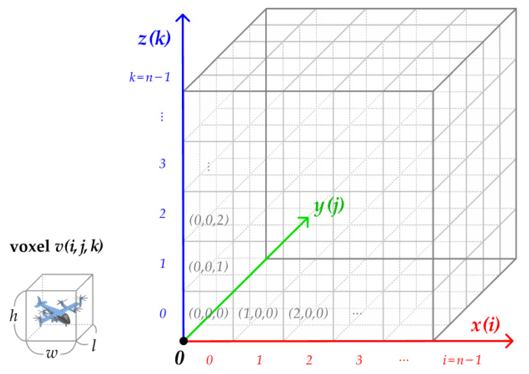
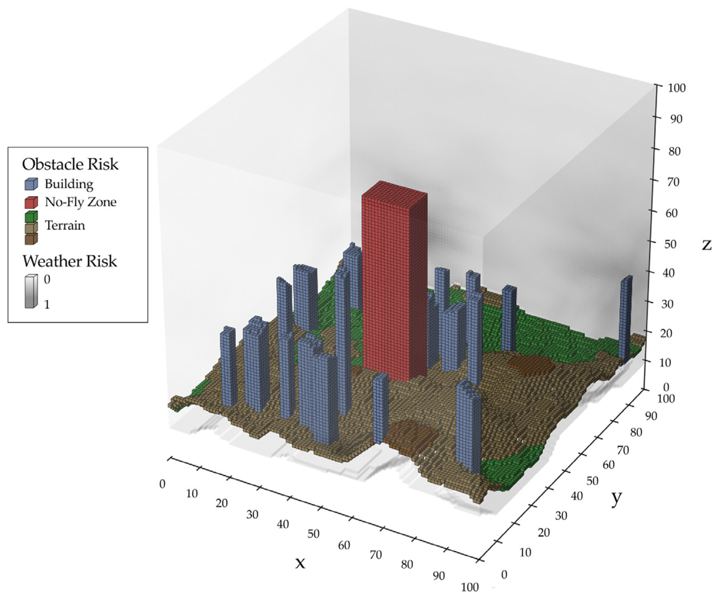
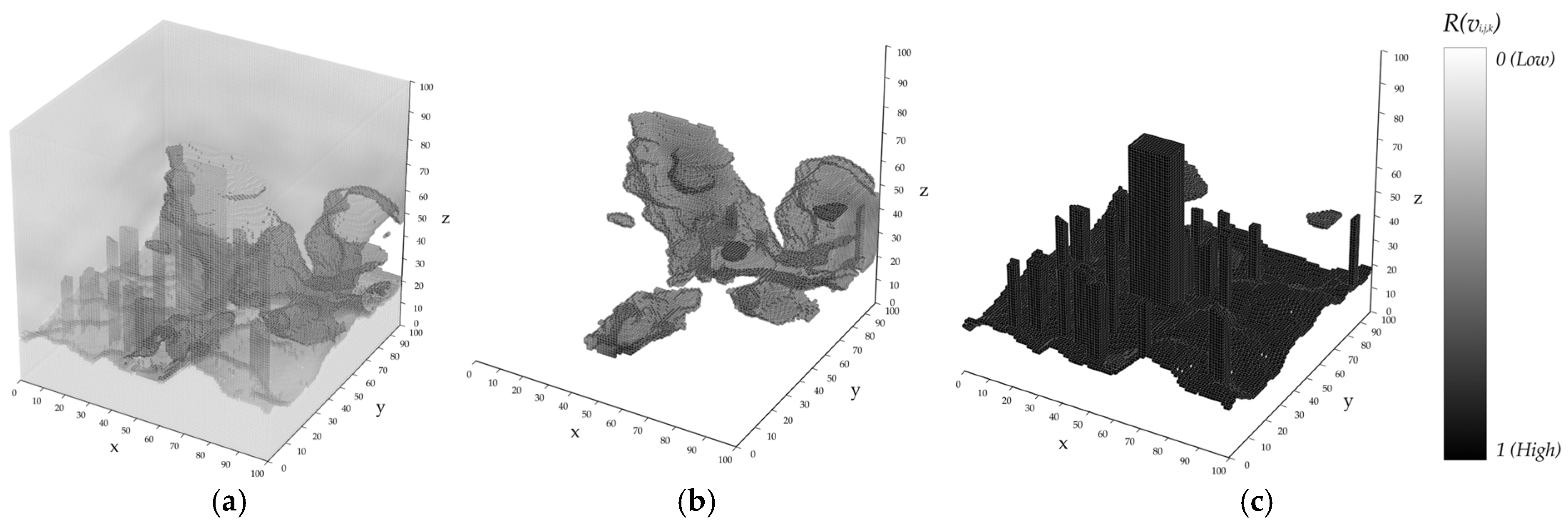
3.1. Flight Risk Map Generation
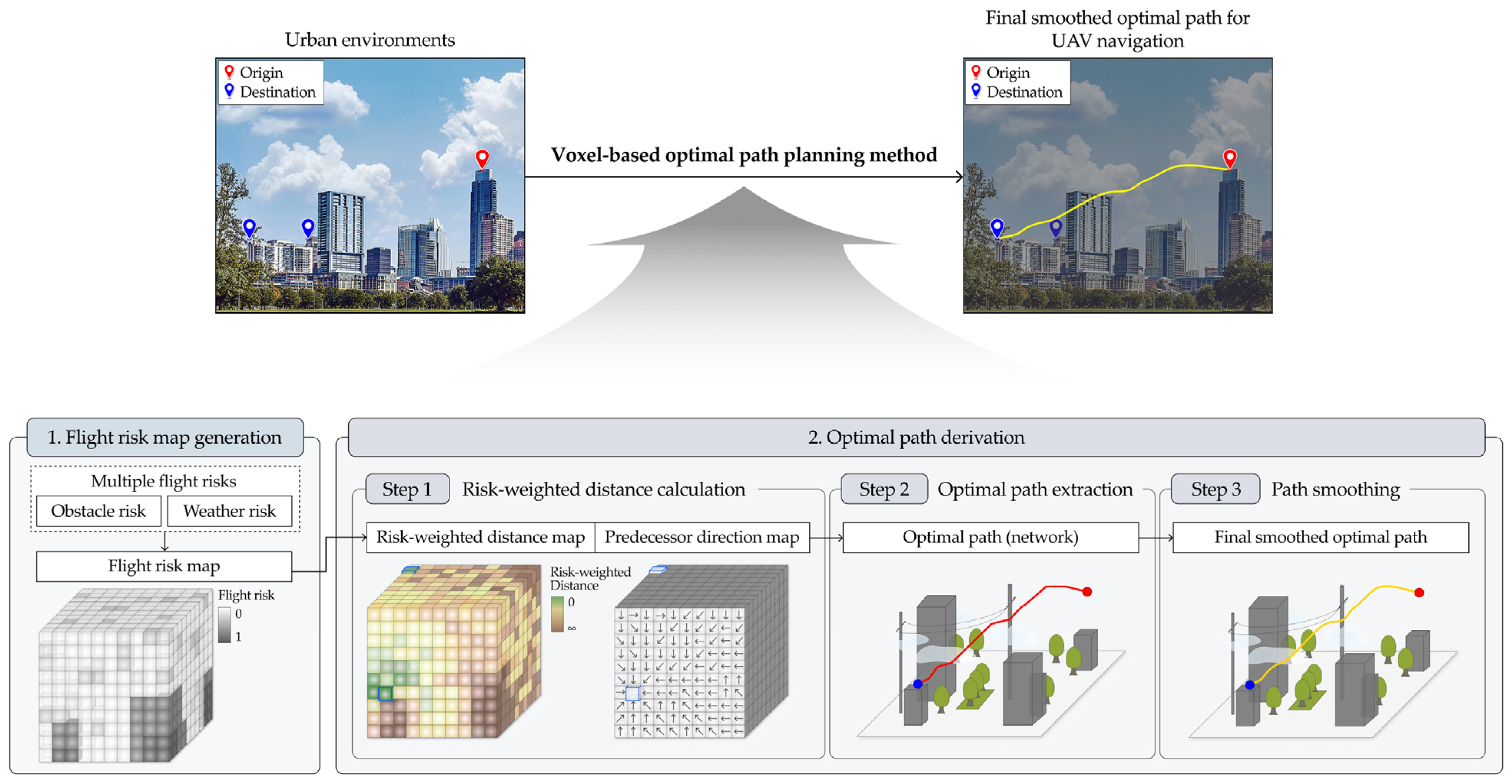
3.2. Optimal Path Derivation
| Algorithm 1 Optimal path derivation |
| Input: flight risk R(v), origin O, destination D, voxel size s Output: final smoothed optimal path G* 1: Calculate risk-weighted distance RD(v), predecessor direction PD(v) by Algorithm 2. 2: Extract optimal path G by Algorithm 3. 3: Calculate final smoothed optimal path G* by [35]. |
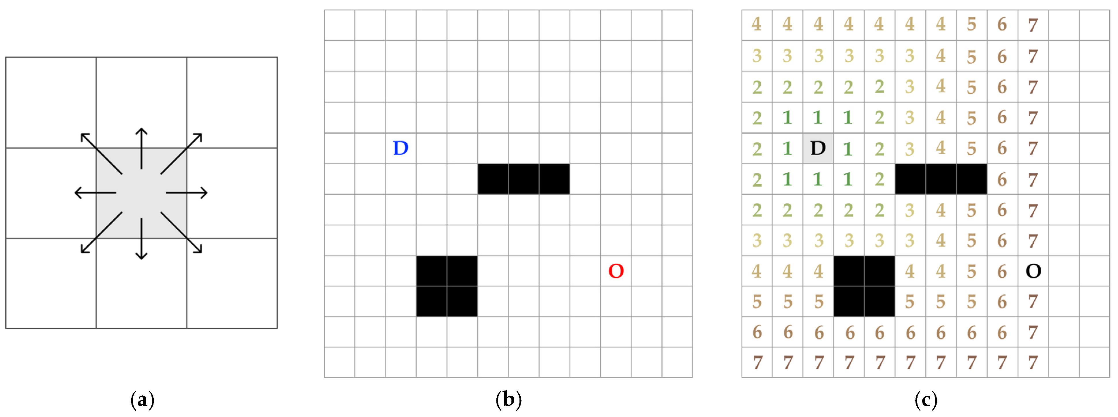
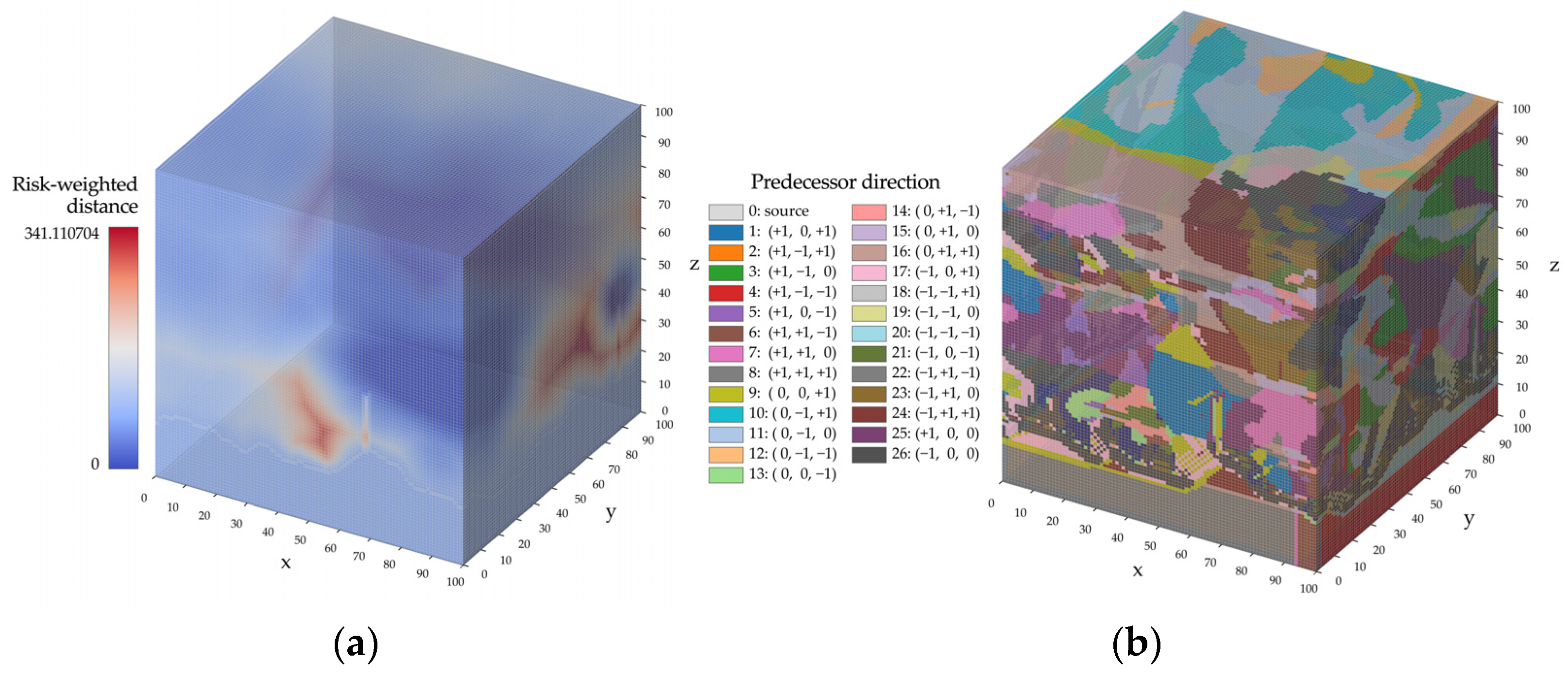
3.2.1. Risk-Weighted Distance Calculation
- Finalized (v): A Boolean variable that indicates whether RD(v) of voxel v has been finalized. Once it is set to True, RD(v) remains fixed and is no longer updated.
- Direction (v): A variable that stores the current predecessor direction of each voxel v before the final assignment of PD(v).
- ActiveList: The set of candidate voxels whose RD(v) has not yet been finalized, storing their RD(v), coordinates (i, j, k), and direction.
| Algorithm 2 Risk-weighted distance calculation |
| Input: flight risk R(v), destination D, voxel size s Output: risk-weighted distance RD(v), predecessor direction PD(v) 1: Initialize RD(v) ← ∞ 2: Initialize PD(v) ← 0 3: Initialize finalized(v) ← False 4: Initialize direction(v) ← 0 5: Initialize ActiveList ← [] 6: 7: for each d ∈ D do 8: RD(d) ← 0 9: PD(d) ← 0 10: Insert d into ActiveList as (RD(d), d(i,j,k), PD(d)) 11: end for 12: 13: while ActiveList not empty do 14: Extract voxel v with minimum RD(v) from ActiveList as (RD(v), v, direction) 15: if finalized(v) then 16: continue 17: end if 18: finalized(v) ← True 19: PD(v) ← direction(v) 20: for each voxel u in the 26-neighborhood of v do 21: if u is out of bounds or finalized(u) then 22: continue 23: end if 24: Calculate RD’(u) by Equation (4) 25: if RD’(u) < RD(u) then 26: Decrease-Key of u in ActiveList to RD(u) 27: direction’(u) ← direction(u→ v) 28: Update u in ActiveList its direction(u) to direction’(u) 29: end if 30: end for 31: end while 32: 33: return RD(·), PD(·) |
3.2.2. Optimal Path Extraction
| Algorithm 3 Optimal path extraction |
| Input: origin O, destination D, predecessor direction PD(v) Output: optimal path G 1: Initialize path ← [] 2: Initialize node ← {}, edge ← {} 3: 4: current ← O 5: Insert current into path 6: 7: while PD(current) ≠ 0 do 8: Convert OD(current) into (Δx, Δy, Δz) 9: current ← current + (Δx, Δy, Δz) 10: Insert current into path 11: end while 12: 13: node ← {center(p) | p ∈ path} 14: edge ← {(pathi−1, pathi) | i = 1,…, |path| − 1} 15: G ← (node, edge) 16: 17: return G |
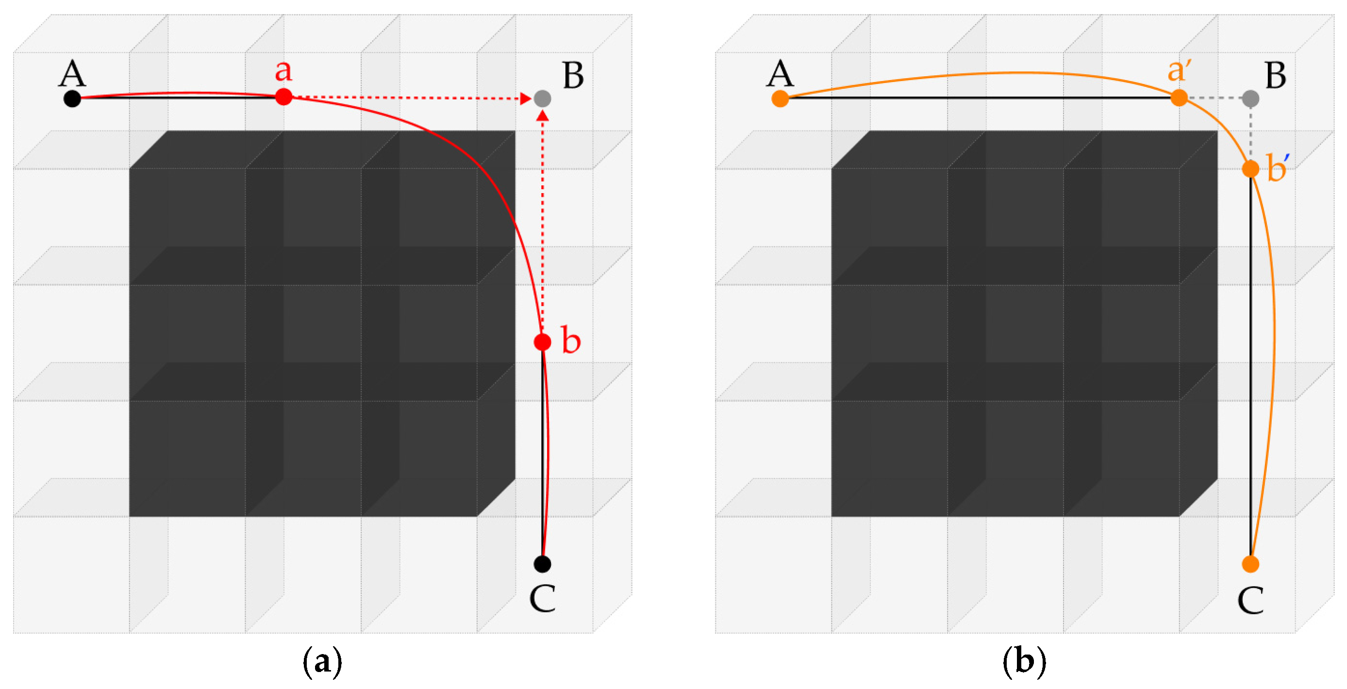
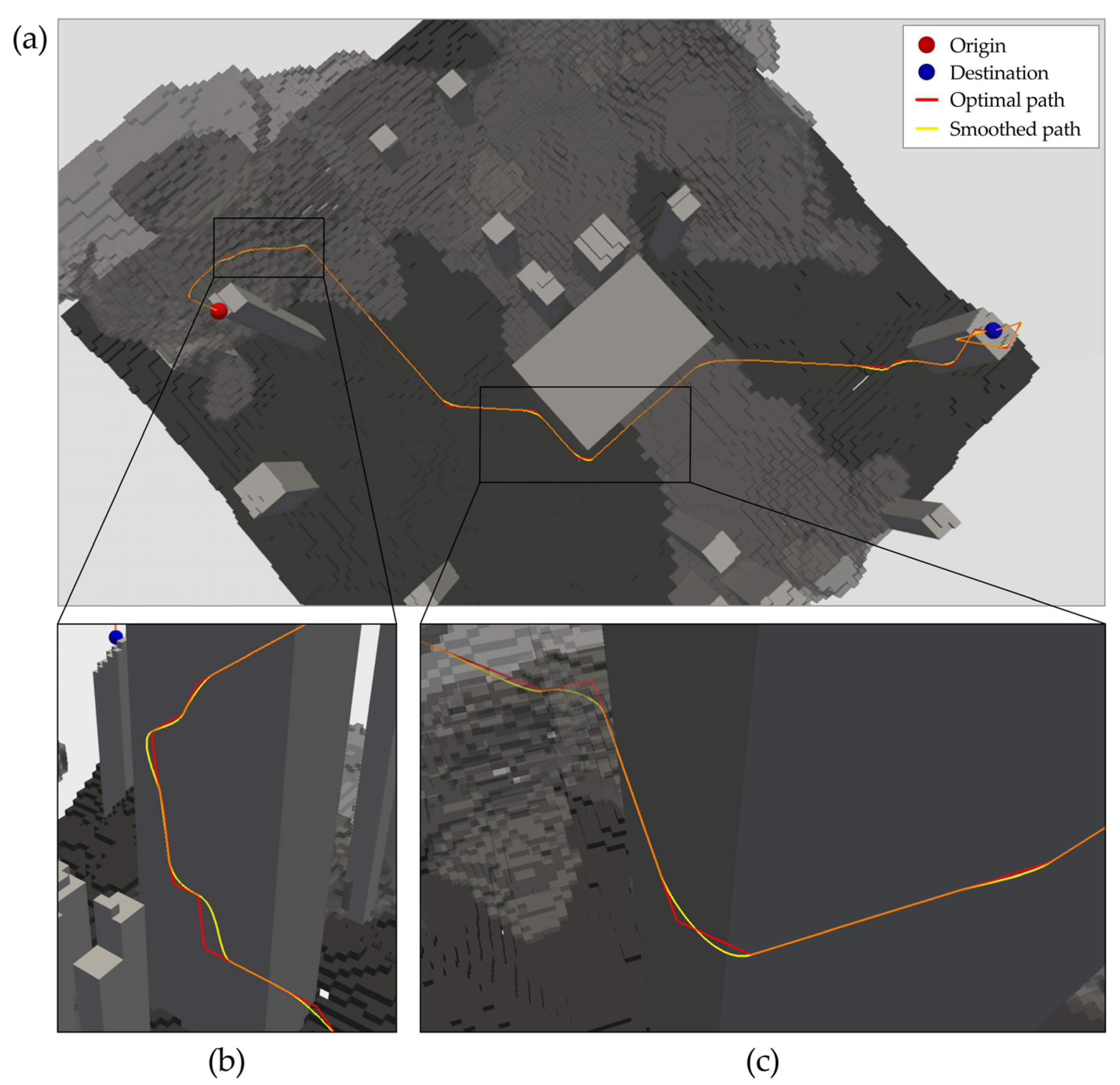
3.2.3. Path Smoothing
4. Implementation
4.1. Stepwise Implementation and Visualization of the Proposed Method
4.2. Quantitative Evaluation of Path Performance Under Experimental Scenarios
5. Discussion
6. Conclusions
Author Contributions
Funding
Data Availability Statement
Conflicts of Interest
Abbreviations
| UAM | Urban Air Mobility |
| eVTOL | Electric Vertical Takeoff and Landing |
| UAV | Unmanned Aerial Vehicle |
| 2D | Two-dimensional |
| 3D | Three-dimensional |
References
- Mitieka, D.; Luke, R.; Twinomurinzi, H.; Mageto, J. Smart Mobility in Urban Areas: A Bibliometric Review and Research Agenda. Sustainability 2023, 15, 6754. [Google Scholar] [CrossRef]
- Cabreira, T.M.; Brisolara, L.B.; Ferreira, P.R., Jr. Survey on Coverage Path Planning with Unmanned Aerial Vehicles. Drones 2019, 3, 4. [Google Scholar] [CrossRef]
- Federal Aviation Administration (FAA). Small Unmanned Aircraft Systems: 14 CFR Part 107—Operating Limitations for Small Unmanned Aircraft (§107.51). 2016. Available online: https://www.ecfr.gov/current/title-14/chapter-I/subchapter-F/part-107 (accessed on 22 September 2025).
- European Union Aviation Safety Agency (EASA). Easy Access Rules for Unmanned Aircraft Systems. 2024. Available online: https://www.easa.europa.eu/en/document-library/easy-access-rules/online-publications/easy-access-rules-unmanned-aircraft-systems (accessed on 22 September 2025).
- Zhang, H.; Tian, T.; Feng, O.; Wu, S.; Zhong, G. Research on Public Air Route Network Planning of Urban Low-Altitude Logistics Unmanned Aerial Vehicles. Sustainability 2023, 15, 12021. [Google Scholar] [CrossRef]
- Niu, L.; Wang, Z.; Lin, Z.; Zhang, Y.; Yan, Y.; He, Z. Voxel-Based Navigation: A Systematic Review of Techniques, Applications, and Challenges. ISPRS Int. J. Geo-Inf. 2024, 13, 461. [Google Scholar] [CrossRef]
- Chiciudean, V.; Oniga, F. Pathfinding in a 3D Grid for UAV Navigation. In Proceedings of the 2022 IEEE 18th International Conference on Intelligent Computer Communication and Processing (ICCP), Cluj-Napoca, Romania, 22–24 September 2022; IEEE: Piscataway, NJ, USA, 2022; pp. 305–311. [Google Scholar] [CrossRef]
- Valiente, G. Adjacency Maps and Efficient Graph Algorithms. Algorithms 2022, 15, 67. [Google Scholar] [CrossRef]
- Tang, Q.; Dou, W. An Effective Method for Computing the Least-Cost Path Using a Multi-Resolution Raster Cost Surface Model. ISPRS Int. J. Geo-Inf. 2023, 12, 287. [Google Scholar] [CrossRef]
- Zhang, H.-Y.; Lin, W.-M.; Chen, A.-X. Path Planning for the Mobile Robot: A Review. Symmetry 2018, 10, 450. [Google Scholar] [CrossRef]
- Tang, H.; Zhang, Y.; Mohmoodian, V.; Charkhgard, H. Automated flight planning of high-density urban air mobility. Transp. Res. Part C Emerg. Technol. 2021, 131, 103324. [Google Scholar] [CrossRef]
- Zhang, N.; Zhang, M.; Low, K.H. 3D path planning and real-time collision resolution of multirotor drone operations in complex urban low-altitude airspace. Transp. Res. Part C Emerg. Technol. 2021, 129, 103123. [Google Scholar] [CrossRef]
- Roseman, C.A.; Argrow, B.M. Weather hazard risk quantification for sUAS safety risk management. J. Atmos. Ocean. Technol. 2020, 37, 1251. [Google Scholar] [CrossRef]
- Teng, Y.; Wang, X.; Wang, L.; Yao, M. The Safety Risk Assessment Method for Logistics UAV Considering Environmental Impacts. In Proceedings of the 2024 IEEE International Conference on Unmanned Systems (ICUS), Nanjing, China, 18–20 October 2024; IEEE: Piscataway, NJ, USA, 2024; pp. 219–224. [Google Scholar] [CrossRef]
- Primatesta, S.; Rizzo, A.; la Cour-Harbo, A. Ground Risk Map for Unmanned Aircraft in Urban Environments. J. Intell. Robot. Syst. 2020, 97, 489–509. [Google Scholar] [CrossRef]
- Hu, X.; Pang, B.; Dai, F.; Low, K.H. Risk assessment model for UAV cost-effective path planning in urban environments. IEEE Access 2020, 8, 150162–150173. [Google Scholar] [CrossRef]
- Sohrabi, S.; Weng, Y.; Das, S.; German Paal, S. Safe Route-Finding: A Review of Literature and Future Directions. Accid. Anal. Prev. 2022, 177, 106816. [Google Scholar] [CrossRef] [PubMed]
- Andaryan, A.Z.; Bell, M.G.; Ramezani, M.; Geers, G. V*: An Efficient Motion Planning Algorithm for Autonomous Vehicles. arXiv 2025, arXiv:2508.06404. [Google Scholar] [CrossRef]
- Dijkstra, E. A note on two problems in connexion with graphs. Numer. Math. 1959, 4, 269–271. [Google Scholar] [CrossRef]
- Hart, P.E.; Nilsson, N.J.; Raphael, B. A formal basis for the heuristic determination of minimum cost paths in graphs. IEEE Trans. Syst. Sci. Cybern. 1968, 4, 100–107. [Google Scholar] [CrossRef]
- Kavraki, L.E.; Svestka, P.; Latombe, J.C.; Overmars, M.H. Probabilistic roadmaps for path planning in high-dimensional configuration spaces. IEEE Trans. Robot. Autom. 1996, 12, 566–580. [Google Scholar] [CrossRef]
- Hsu, D.; Kindel, R.; Latombe, J.C.; Rock, S. Randomized kinodynamic motion planning with moving obstacles. Int. J. Robot. Res. 2002, 21, 233–255. [Google Scholar] [CrossRef]
- LaValle, S.M. Rapidly-Exploring Random Trees: A New Tool for Path Planning. 1998. Available online: http://lavalle.pl/papers/Lav98c.pdf (accessed on 11 November 2025).
- Liu, L.; Wang, X.; Yang, X.; Liu, H.; Li, J.; Wang, P. Path Planning Techniques for Mobile Robots: Review and Prospect. Expert Syst. Appl. 2023, 227, 120254. [Google Scholar] [CrossRef]
- Sun, Y.; Li, H.; Tong, X.; Lei, Y.; Wang, D.; Guo, C.; Tang, J.; Shang, Y. A Multi-Unmanned Aerial Vehicle Fast Path-Planning Method Based on Non-Rigid Hierarchical Discrete Grid Voxel Environment Modeling. Int. J. Appl. Earth Obs. Geoinf. 2023, 116, 103139. [Google Scholar] [CrossRef]
- Goodchild, M.F. An evaluation of lattice solutions to the problem of corridor location. Environ. Plan. A 1977, 9, 727–738. [Google Scholar] [CrossRef]
- Murphy, R. Introduction to AI Robotics; MIT Press: Cambridge, MA, USA, 2019. [Google Scholar]
- Zelenka, J.; Kasanicky, T. Outdoor UAV Control and Coordination System Supported by Biological Inspired Method. In Proceedings of the 2014 23rd International Conference on Robotics in Alpe-Adria-Danube Region (RAAD), Smolenice, Slovakia, 3–5 September 2014; pp. 1–7. [Google Scholar] [CrossRef]
- Marchese, F.M. A directional diffusion algorithm on cellular automata for robot path-planning. Future Gener. Comput. Syst. 2020, 18, 983–994. [Google Scholar] [CrossRef]
- Ronchi, E. Developing and Validating Evacuation Models for Fire Safety Engineering. Fire Saf. J. 2021, 120, 103020. [Google Scholar] [CrossRef]
- Tang, C.; Liang, Y.; Yu, S.; Sun, R.; Zheng, J. Autonomous 3D Exploration of Indoor Environment Based on Wavefront Algorithm. In Proceedings of the 2020 IEEE International Conference on Networking, Sensing and Control (ICNSC), Nanjing, China, 30 October–2 November 2020; IEEE: Piscataway, NJ, USA, 2020; pp. 1–6. [Google Scholar] [CrossRef]
- Psotka, M.; Duchoň, F.; Roman, M.; Michal, T.; Michal, D. Global Path Planning Method Based on a Modification of the Wavefront Algorithm for Ground Mobile Robots. Robotics 2023, 12, 25. [Google Scholar] [CrossRef]
- Ghai, B.; Shukla, A. Wave Front Method Based Path Planning Algorithm for Mobile Robots. In Proceedings of the First International Conference on Information and Communication Technology for Intelligent Systems, Ahmedabad, India, 28–29 November 2015; Satapathy, S., Das, S., Eds.; Smart Innovation, Systems and Technologies; Springer: Cham, Switzerland, 2016; Volume 51, pp. 281–288. [Google Scholar] [CrossRef]
- ESRI. How Cost Distance Tools Work. Available online: https://desktop.arcgis.com/en/arcmap/10.4/tools/spatial-analyst-toolbox/how-the-cost-distance-tools-work.htm (accessed on 22 August 2025).
- Li, X.; Gao, X.; Zhang, W.; Hao, L. Smooth and collision-free trajectory generation in cluttered environments using cubic B-spline form. Mech. Mach. Theory 2022, 169, 104606. [Google Scholar] [CrossRef]
- Piegl, L.; Tiller, W. The NURBS Book, 2nd ed.; Springer: New York, NY, USA, 1996. [Google Scholar]
- Lv, T.; Fu, J.; Li, B. Design and Application of Multi-Dimensional Visualization System for Large-Scale Ocean Data. ISPRS Int. J. Geo-Inf. 2022, 11, 491. [Google Scholar] [CrossRef]
- Kaya, U.C.; Dogan, A.; Huber, M. A Probabilistic Risk Assessment Framework for the Path Planning of Safe Task-Aware UAS Operations. In Proceedings of the AIAA Scitech 2019 Forum, San Diego, CA, USA, 7–11 January 2019. [Google Scholar] [CrossRef]
- Paielli, R.A. Trajectory generation based on power for urban air mobility. Front. Aerosp. Eng. 2023, 2, 1278726. [Google Scholar] [CrossRef]




| Scenario | Path | Length (m) | Flight Risk | |||
|---|---|---|---|---|---|---|
| Total (Equation (5)) | Average (/m) | Min | Max | |||
| 1 | Reference path | 1691.263 | 402.796 | 0.238 | 0.085 | 0.474 |
| Optimal path | 2449.17 | 174.869 | 0.071 | 0.003 | 0.434 | |
| Final smoothed optimal path | 2412.989 | 174.357 | 0.072 | 0.003 | 0.434 | |
| 2 | Reference path | 1704.385 | 321.11 | 0.188 | 0.124 | 0.262 |
| Optimal path | 2328.484 | 132.982 | 0.057 | 0.002 | 0.167 | |
| Final smoothed optimal path | 2276.284 | 129.317 | 0.057 | 0.002 | 0.188 | |
Disclaimer/Publisher’s Note: The statements, opinions and data contained in all publications are solely those of the individual author(s) and contributor(s) and not of MDPI and/or the editor(s). MDPI and/or the editor(s) disclaim responsibility for any injury to people or property resulting from any ideas, methods, instructions or products referred to in the content. |
© 2025 by the authors. Published by MDPI on behalf of the International Society for Photogrammetry and Remote Sensing. Licensee MDPI, Basel, Switzerland. This article is an open access article distributed under the terms and conditions of the Creative Commons Attribution (CC BY) license (https://creativecommons.org/licenses/by/4.0/).
Share and Cite
Jang, M.; Kim, D.; Lee, J. A Voxel-Based Optimal Path Planning Method for UAV Navigation in Smart Cities. ISPRS Int. J. Geo-Inf. 2025, 14, 457. https://doi.org/10.3390/ijgi14120457
Jang M, Kim D, Lee J. A Voxel-Based Optimal Path Planning Method for UAV Navigation in Smart Cities. ISPRS International Journal of Geo-Information. 2025; 14(12):457. https://doi.org/10.3390/ijgi14120457
Chicago/Turabian StyleJang, Min, Dohee Kim, and Jiyeong Lee. 2025. "A Voxel-Based Optimal Path Planning Method for UAV Navigation in Smart Cities" ISPRS International Journal of Geo-Information 14, no. 12: 457. https://doi.org/10.3390/ijgi14120457
APA StyleJang, M., Kim, D., & Lee, J. (2025). A Voxel-Based Optimal Path Planning Method for UAV Navigation in Smart Cities. ISPRS International Journal of Geo-Information, 14(12), 457. https://doi.org/10.3390/ijgi14120457


