A Review of Google Earth Engine for Land Use and Land Cover Change Analysis: Trends, Applications, and Challenges
Abstract
1. Introduction
2. Significance and Objective
3. Summary of Recent Review Articles
4. Materials and Methods
5. Results
5.1. Time Trend Analysis of Search Engine Results on GEE and LULC-Related Publications
5.2. Journals Analysis
5.3. Geographical Distribution of Studies
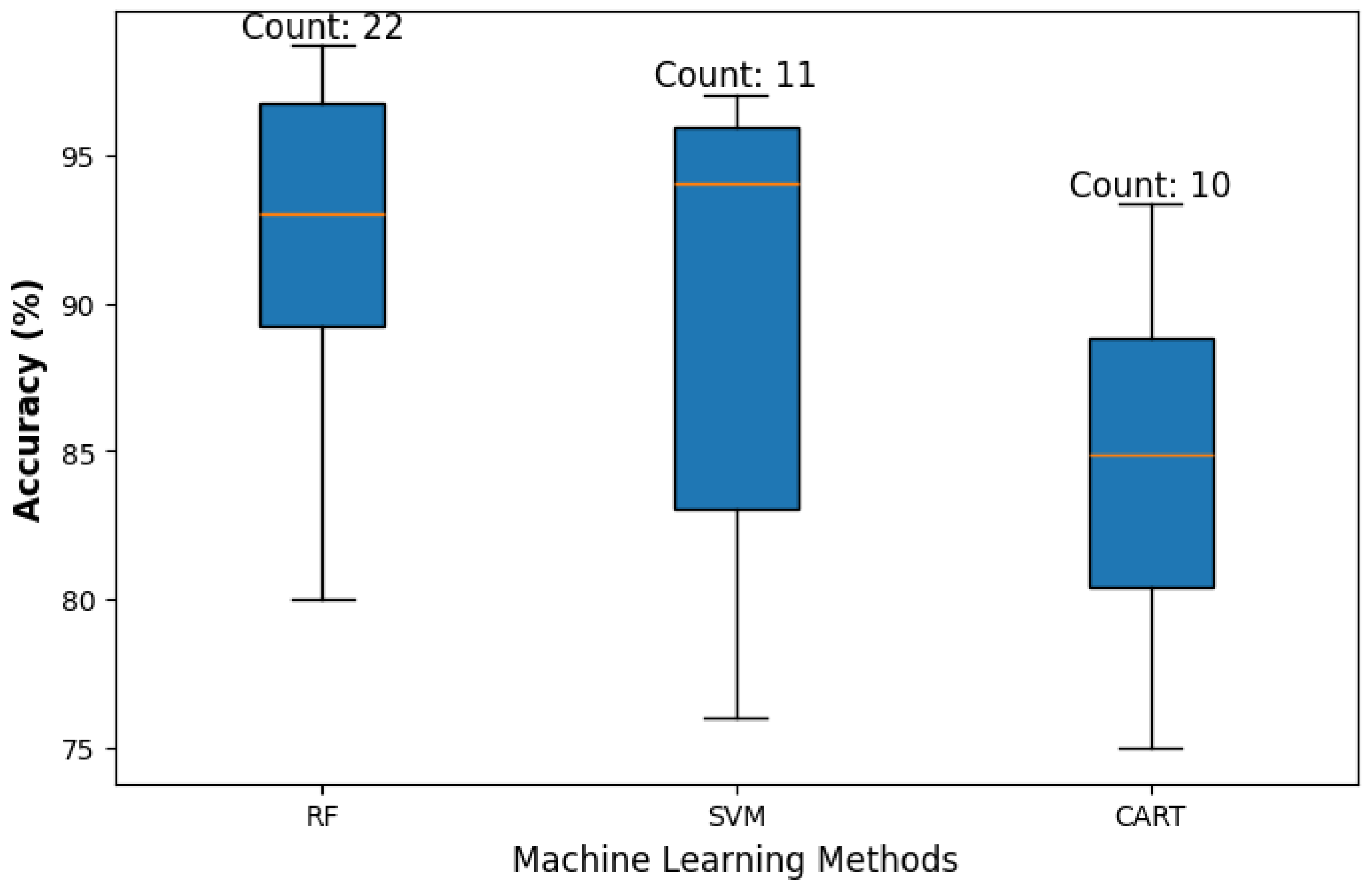
5.4. LULC-Related Methods, Algorithms, and Applications
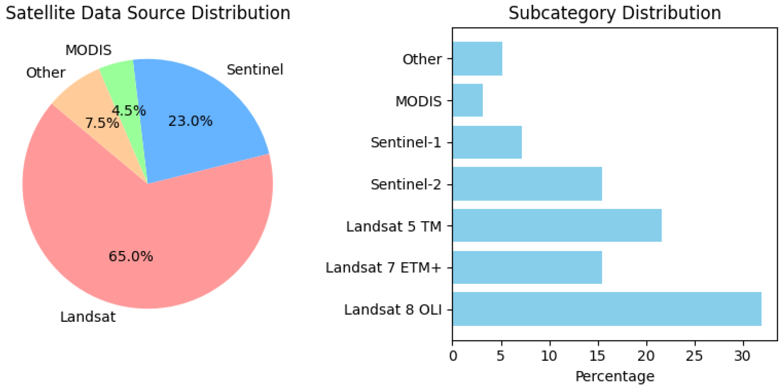
5.5. Satellite Imagery Usage
5.6. Studies Periods
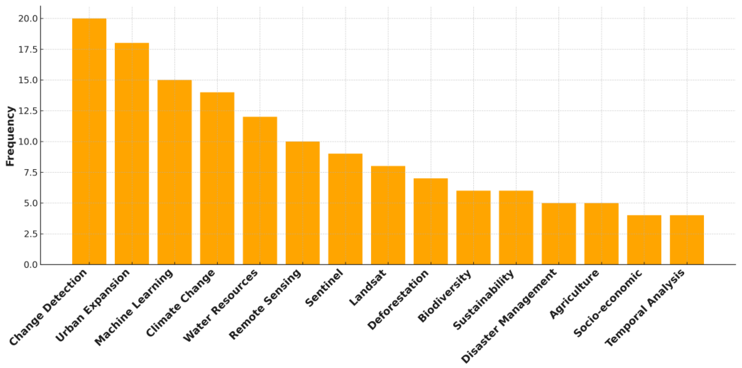
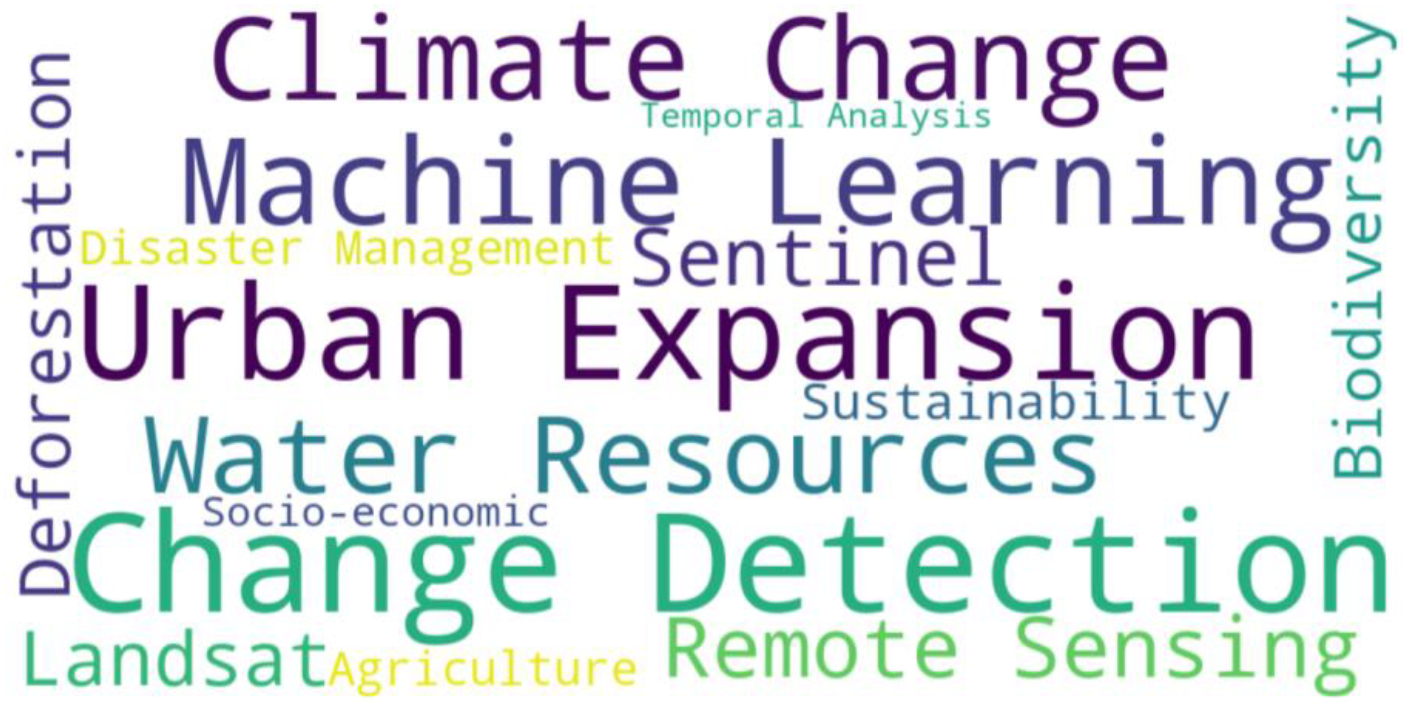
5.7. Keyword Analysis
6. Discussion
6.1. Expansion of Data Usage and Methodological Shifts
6.2. Geographic and Thematic Diversification
6.3. Increasing Specialization and Interdisciplinary Applications
6.4. Comparative Insights on GEE’s Future Directions
6.5. Reported Limitations of GEE in LULC
6.6. Limitations of the Study
7. Conclusions
Author Contributions
Funding
Data Availability Statement
Conflicts of Interest
Abbreviations
| AI | Artificial Intelligence |
| ALOS | Advanced Land Observing Satellite |
| ANN | Artificial Neural Networks |
| APIs | Application Programming Interfaces |
| AWS | Amazon Web Services |
| CART | Classification and Regression Tree |
| DL | Deep Learning |
| FCNN | Fully Convolutional Neural Networks |
| GEE | Google Earth Engine |
| GPU | Graphics Processing Unit |
| GWR | Geographically Weighted Regression |
| InVEST | Integrated Valuation of Ecosystem Services and Tradeoffs |
| LSMA | Linear Spectral Mixture Analysis |
| LST | Land Surface Temperature |
| LULC | Land Use and Land Cover |
| ML | Machine Learning |
| MLH | Maximum Likelihood Algorithm |
| MLPNN | Multilayer Perceptron Neural Network |
| MLR | Multiple Linear Regression |
| MODIS | Moderate Resolution Imaging Spectroradiometer |
| NAIP | National Agriculture Imagery Program |
| NDBI | Normalized Difference Built-up Index |
| NDVI | Normalized Difference Vegetation Index |
| NDWI | Normalized Difference Water Index |
| NOAA | National Oceanic and Atmospheric Administration |
| NRT | Near Real-Time |
| NUACI | Normalized Urban Areas Composite Index |
| RF | Random Forest |
| RUESVMs | Random Under-sampling Ensemble of Support Vector Machines |
| SAR | Synthetic Aperture Radar |
| SNIC | Simple Non-Iterative Clustering |
| SVM | Support Vector Machine |
| TWINNS | TWIn Neural Networks for Sentinel data |
Appendix A
| Study | Scope | Main Findings |
| (Gorelick et al., 2017) [11] | A comprehensive analysis was conducted on multiple factors of GEE, involving its data catalog, system structure, functionalities, data dissemination mechanisms, efficiency, applications, and reported challenges. | Provided a summary of frequently used datasets in Google Earth Engine’s data catalog. Discussed a simplified system architecture diagram. The paper illustrates a summary of Google Earth Engine functions. Examined GEE System modeling, structure, and performance assessment. Evaluate the data dissemination procedure and approaches. The paper discussed future directions and challenges in utilizing GEE as a valuable tool for analyzing global issues. |
| (Kumar & Mutanga, 2018) [47] | Conducted an intensive analysis of usage patterns on the GEE platform, focusing on determining its adoption by researchers in developing countries. | The highest number of articles was published in the journals “Remote Sensing”, followed by “Remote Sensing of Environment”. A wide range of applications was conducted, involving different areas of research such as forestry and vegetation, as well as investigating various medical diseases such as Malaria. The most widely utilized data in the research were Landsat imagery datasets. GEE usage was primarily associated with institutions located in developed countries, and most study sites were also situated in these regions. A limited number of publications were conducted by institutions located in less developed nations. |
| (Mutanga & Kumar, 2019) [25] | This special issue, authored by experts in the field, illustrates 22 papers that examine key applications of Google Earth Engine (GEE). The topics covered included vegetation applications and mapping, land-cover changes, agricultural and disaster management, as well as various areas within related disciplines. | The practical implementation of GEE across a range of applications. GEE is capable of processing large datasets at different scales and developing automated models suitable for operational use. There was a higher level of GEE usage in developed countries compared to developing regions such as Africa. Landsat was recognized as the most extensively utilized dataset. |
| (Tamiminia et al., 2020) [14] | A review was conducted on 349 scientific papers that utilized GEE as a leading platform, evaluating various factors including the datasets and satellite sensors used, areas of interest, data resolutions, applications, methodologies, and analytical strategies. | Demonstrated and discussed a wide range of GEE-related papers in different disciplines, such as urbanization studies and environmental challenges at both national and worldwide levels. Remotely sensed data were employed in 90% of the reviewed articles, while the remaining 10% relied on pre-processed or pre-existing datasets for their research. Landsat imagery datasets with moderate spatial resolution were intensively utilized. The most commonly applied techniques for processing utilized datasets were Random Forest and Linear Regression Algorithms. The normalized difference vegetation index (NDVI) was used in 27% of the reviewed articles for vegetation, crop, and land-cover analysis, as well as for research on drought and desertification. The results of this study demonstrate that GEE has achieved remarkable advancements in tackling global challenges related to geospatial data processing. |
| (Amani et al., 2020) [12] | Examined 450 scientific papers focusing on various applications of the GEE platform, including its capabilities, datasets, functionalities, benefits, challenges, and diverse aspects of applications. | Landsat and Sentinel datasets have been extensively utilized by users of Google Earth Engine (GEE). Data classification frequently employs supervised machine learning algorithms, with Random Forest (RF) being a commonly used example. The intensive use of GEE covers a broad range of applications, including land use and land cover (LULC) analysis, hydrological studies, urbanization modeling, disaster monitoring, global warming assessment, and various data processing tasks. Recent years have witnessed a notable rise in GEE-related publications. In the future, it is expected that an even broader range of users from diverse disciplines will adopt GEE to undertake their challenges in big data processing. |
| (Q. Zhao et al., 2021) [7] | A comprehensive review analysis was conducted on the applications and evolving trends of Google Earth (GE) and Google Earth Engine (GEE), focusing on scientific papers published up to January 2021. | Over the 14 years from 2006 to 2020, the number of publications that employed GE and GEE increased from 2 to 530, marking a significant growth in the research interest in GE and GEE. Compared to GEE, GE research spanned various disciplines of study, including biology, education, health, and economics, and was published in a broader range of scientific journals. Keywords such as “land cover”, “water”, “model”, “vegetation”, and “forest” were commonly used in both studies related to GE and GEE. Publications from the United States, China, and the United Kingdom were among the top countries that utilized GE and GEE as a significant tool in the research field, driving a considerable portion of research and applications. GEE serves as a crucial tool for analysis, while GE has primarily been used as a supporting tool for visualization. |
| (Yang et al., 2022) [15] | A systematic review on integrating AI methods with Google Earth Engine (GEE). This paper analyzed 200 articles that combined GEE with AI, focusing on its applications and the techniques utilized in remote sensing and geospatial analysis. | The number of studies integrating GEE and AI has significantly increased since 2019, illustrating the potential of this combination for various aspects of geospatial analysis. GEE and AI were integrated in various fields of research, including yield mapping, land use land cover (LULC) analysis, vegetation and wetland mapping, water body classification, and forest monitoring. Machine learning (ML) was the dominant approach, with Random Forest (RF) and Support Vector Machines (SVM) being the most used algorithms. This paper highlights the capability of integrating GEE and AI for analyzing vast amounts of geospatial datasets. It identifies future research directions to enhance the reliability and effectiveness of this integration. |
| (Pham-Duc et al., 2023) [13] | This study examined the trends and key applications of Google Earth Engine (GEE) in remote sensing and Earth science research through a bibliometric review analysis of 1995 scientific papers up to December 2022. | GEE-related research has increased in recent years, with about 85% of papers being published in the last three years. GEE’s studies are primarily focused on various fields of research, such as land studies, environmental management, biological research, global warming, hydrological studies, and agricultural mapping. Researchers from China and the United States have contributed the highest number of publications related to GEE studies. While the “Remote Sensing” journal published the most articles, “Remote Sensing of Environment” gained the most citations, indicating their significant impact in geospatial research. Landsat data was recognized as the most significantly used dataset. The most frequently employed ML algorithms were Random Forest (RF), Support Vector Machines (SVM), and decision trees. |
| (Jangid et al., 2023) [59] | Examined the most popular techniques used by researchers to conduct land use land cover (LULC) classification with the integration of Google Earth Engine (GEE) and Machine Learning (ML) algorithms, and presented challenges and guidelines for future research. | The paper discussed the effectiveness of machine learning algorithms such as Random Forest (RF), Support Vector Machine (SVM), and CART in LULC classification. The article highlighted several challenges in LULC classification, including data quality, selecting the appropriate algorithms, and the necessity of using an accurate training sample for Machine Learning (ML) models. This paper demonstrates the potential of integrating GEE and ML algorithms for conducting accurate LULC classification and analysis. |
| (Velastegui-Montoya et al., 2023) [20] | A comprehensive review analysis was conducted on GEE-related publications. The process consisted of four phases: selecting search criteria, collecting data from 2011 to 2022, reviewing the published articles using bibliometric tools, and analyzing the results. | The leading research contributors on utilizing, visualizing, and processing geospatial data on GEE were researchers from China and the United States. GEE-related research has experienced a significant rise, with 2800 papers published between 2011 and 2022, and researchers from 125 countries worldwide have contributed to the field. GEE is applied in various fields of research, including land studies, environmental monitoring, disaster management, agriculture, biology, and engineering. The co-citation analysis highlighted the relationships among researchers who have utilized GEE in their studies. GEE is recognized as a valuable tool with a wide range of applications across multiple disciplines. |
| (Pérez-Cutillas et al., 2023) [10] | The study conducted a systematic review and meta-analysis on 343 scientific papers published between 2020 and 2022 to understand the evolution of GEE research, identifying its applications, trends, potential, datasets used, and analytical methodologies applied. | The most popular satellite dataset used in GEE-related publications was Landsat 8 data, with 25% of the studies. The Random Forest (RF) algorithm was the most applied approach to conduct data classifications in 31% of the reviewed studies. Water sources evaluation and forecasting were the most frequent methodological applications. Despite the recent global significance of the COVID-19 pandemic, few articles have addressed the pandemic. Researchers from China, the United States, and India conducted the highest percentage of publications. In terms of citation impact, “Remote Sensing” and “Remote Sensing of Environment” journals were the top publishers. Random Forest (RF) algorithm and agriculture research were the most cited. |
| Limitation | Description |
| Data & Processing Challenges | Cloud cover and Data Gaps: Cloud cover is a challenge for datasets such as Landsat, creating gaps in data that can limit its usefulness in regions with frequent cloud cover [15,64,69]. Resolution Limitations: The resolution of imagery used in GEE can cause difficulties in detecting small-scale features, especially in built-up areas near dense vegetation [68,72]. Fixed Computing Constraints: Unlike local models, where users have complete control over computing resources, GEE enforces fixed platform-based constraints, which limit flexibility, especially for simulations at finer scales [58]. Lack of User Control over Data Chunking: GEE does not allow users to define chunk sizes for efficient data storage and computation, which can impact performance, especially with large datasets [69]. |
| Computational & Performance Constraints | Memory Constraints: GEE has memory limitations when handling large datasets [15,63,64]. GEE API Limitations: The existing image analysis tools are restricted within the GEE’s API. Standard preprocessing methods like atmospheric correction are not yet implemented [12]. Users require in-depth knowledge of GEE’s algorithms and cloud-based computing performance for custom tool development [7,14]. Computation Effort Increases with Dataset Size: The processing time in GEE increases significantly with larger datasets, particularly when dealing with high-resolution or large-scale time-series data, taking a long time to process [7,14,69]. |
| Analytical & Methodological Challenges | Noise in Classification: RF classification, as the most frequent and widely used method within GEE, may produce random noise due to its pixel-oriented nature, which can lead to inaccurate boundaries and finer classification results [67]. GEE lacks efficient segmentation algorithms for object-based image analysis, and this may be considered a technical limitation in the platform [12,47]. Training Samples: Users are restricted by the number of training samples and input features that can be used for classification purposes [7,12]. Supporting Spatio-Temporal Analysis: GEE has a challenge with handling spatial and temporal analyses together in a seamless manner, which limits its usability for some studies [69]. Data Mining Models: GEE’s data mining tools are limited, with a few classification algorithms like CART, RF, and SVM [7,12]. Deep Learning Integration: GEE was linked to only TensorFlow Deep Learning algorithm in 2019, and it can be accessed for analysis and classification purposes in the GEE platform, while other Deep Learning models cannot be directly implemented in GEE [7,14,15]. This can be considered a limitation in the GEE platform and could be enhanced by connecting more Machine Learning models and making them available for users. |
| Integration & Collaboration Issues | Multi-User Collaboration Challenges: GEE has limitations in supporting multi-user collaboration, making it difficult for multiple users to work on shared projects effectively [61]. Multi-Source Data Integration: GEE faces challenges when improving spatial resolution (e.g., from 1 km to 30 m), mainly due to issues with data availability, multi-source data interoperability, and computational requirements [58]. |
| Security & Privacy concerns | Data is stored on private company servers, which raises privacy concerns for many governmental agencies and private companies [7,12]. |
References
- Bathe, K.D.; Patil, N.S. Assessment of Land Use-Land Cover Dynamics and Its Future Projection through Google Earth Engine, Machine Learning and QGIS-MOLUSCE: A Case Study in Jagatsinghpur District, Odisha, India. J. Earth Syst. Sci. 2024, 133, 111. [Google Scholar] [CrossRef]
- Chi, M.; Plaza, A.; Benediktsson, J.A.; Sun, Z.; Shen, J.; Zhu, Y. Big Data for Remote Sensing: Challenges and Opportunities. Proc. IEEE 2016, 104, 2207–2219. [Google Scholar] [CrossRef]
- Sulova, A.; Jokar Arsanjani, J. Exploratory Analysis of Driving Force of Wildfires in Australia: An Application of Machine Learning within Google Earth Engine. Remote Sens. 2020, 13, 10. [Google Scholar] [CrossRef]
- Venter, Z.S.; Barton, D.N.; Chakraborty, T.; Simensen, T.; Singh, G. Global 10 m Land Use Land Cover Datasets: A Comparison of Dynamic World, World Cover and Esri Land Cover. Remote Sens. 2022, 14, 4101. [Google Scholar] [CrossRef]
- Atesoglu, A.; Ozel, H.B.; Varol, T.; Cetin, M.; Baysal, B.U.; Bulut, F.S. Monitoring Land Cover/Use Conversions in Türkiye Wetlands Using Collect Earth. J. Indian Soc. Remote Sens. 2025, 53, 1979–1994. [Google Scholar] [CrossRef]
- Lin, L.; Hao, Z.; Post, C.J.; Mikhailova, E.A.; Yu, K.; Yang, L.; Liu, J. Monitoring Land Cover Change on a Rapidly Urbanizing Island Using Google Earth Engine. Appl. Sci. 2020, 10, 7336. [Google Scholar] [CrossRef]
- Zhao, Q.; Yu, L.; Li, X.; Peng, D.; Zhang, Y.; Gong, P. Progress and Trends in the Application of Google Earth and Google Earth Engine. Remote Sens. 2021, 13, 3778. [Google Scholar] [CrossRef]
- Brown, C.F.; Brumby, S.P.; Guzder-Williams, B.; Birch, T.; Hyde, S.B.; Mazzariello, J.; Czerwinski, W.; Pasquarella, V.J.; Haertel, R.; Ilyushchenko, S.; et al. Dynamic World, Near Real-Time Global 10 m Land Use Land Cover Mapping. Sci. Data 2022, 9, 251. [Google Scholar] [CrossRef]
- Liu, X.; Hu, G.; Chen, Y.; Li, X.; Xu, X.; Li, S.; Pei, F.; Wang, S. High-Resolution Multi-Temporal Mapping of Global Urban Land Using Landsat Images Based on the Google Earth Engine Platform. Remote Sens. Environ. 2018, 209, 227–239. [Google Scholar] [CrossRef]
- Pérez-Cutillas, P.; Pérez-Navarro, A.; Conesa-García, C.; Zema, D.A.; Amado-Álvarez, J.P. What Is Going on within Google Earth Engine? A Systematic Review and Meta-Analysis. Remote Sens. Appl. Soc. Environ. 2023, 29, 100907. [Google Scholar] [CrossRef]
- Gorelick, N.; Hancher, M.; Dixon, M.; Ilyushchenko, S.; Thau, D.; Moore, R. Google Earth Engine: Planetary-Scale Geospatial Analysis for Everyone. Remote Sens. Environ. 2017, 202, 18–27. [Google Scholar] [CrossRef]
- Amani, M.; Ghorbanian, A.; Ahmadi, S.A.; Kakooei, M.; Moghimi, A.; Mirmazloumi, S.M.; Moghaddam, S.H.A.; Mahdavi, S.; Ghahremanloo, M.; Parsian, S.; et al. Google Earth Engine Cloud Computing Platform for Remote Sensing Big Data Applications: A Comprehensive Review. IEEE J. Sel. Top. Appl. Earth Obs. Remote Sens. 2020, 13, 5326–5350. [Google Scholar] [CrossRef]
- Pham-Duc, B.; Nguyen, H.; Phan, H.; Tran-Anh, Q. Trends and Applications of Google Earth Engine in Remote Sensing and Earth Science Research: A Bibliometric Analysis Using Scopus Database. Earth Sci. Inform. 2023, 16, 2355–2371. [Google Scholar] [CrossRef]
- Tamiminia, H.; Salehi, B.; Mahdianpari, M.; Quackenbush, L.; Adeli, S.; Brisco, B. Google Earth Engine for Geo-Big Data Applications: A Meta-Analysis and Systematic Review. ISPRS J. Photogramm. Remote Sens. 2020, 164, 152–170. [Google Scholar] [CrossRef]
- Yang, L.; Driscol, J.; Sarigai, S.; Wu, Q.; Chen, H.; Lippitt, C.D. Google Earth Engine and Artificial Intelligence (AI): A Comprehensive Review. Remote Sens. 2022, 14, 3253. [Google Scholar] [CrossRef]
- Binh, N.A.; Nhut, H.S.; An, N.N.; Phuong, T.A.; Hanh, N.C.; Thao, G.T.P.; Pham, T.T.; Hong, P.V.; Ha, L.T.T.; Bui, D.T.; et al. Thirty-Year Dynamics of LULC at the Dong Thap Muoi Area, Southern Vietnam, Using Google Earth Engine. ISPRS Int. J. Geo-Inf. 2021, 10, 226. [Google Scholar] [CrossRef]
- Hird, J.; DeLancey, E.; McDermid, G.; Kariyeva, J. Google Earth Engine, Open-Access Satellite Data, and Machine Learning in Support of Large-Area Probabilistic Wetland Mapping. Remote Sens. 2017, 9, 1315. [Google Scholar] [CrossRef]
- Amaefuna, R.O.; Chukwudi, D.O. Analysis Of Land Use And Land Cover Changes In Port Harcourt Metropolis Using Geospatial Techniques. IOSR J. Environ. Sci. Toxicol. Food Technol. 2024, 18, 38–44. [Google Scholar] [CrossRef]
- Felix Justiniano, E.; Rodrigues Dos Santos Junior, E.; Malheiros De Melo, B.; Victor Nascimento Siqueira, J.; Gomes Morato, R.; Fantin, M.; Cesar Pedrassoli, J.; Roberto Martines, M.; Shinji Kawakubo, F. Proposal for an Index of Roads and Structures for the Mapping of Non-Vegetated Urban Surfaces Using OSM and Sentinel-2 Data. Int. J. Appl. Earth Obs. Geoinf. 2022, 109, 102791. [Google Scholar] [CrossRef]
- Velastegui-Montoya, A.; Montalván-Burbano, N.; Carrión-Mero, P.; Rivera-Torres, H.; Sadeck, L.; Adami, M. Google Earth Engine: A Global Analysis and Future Trends. Remote Sens. 2023, 15, 3675. [Google Scholar] [CrossRef]
- Al-Dousari, A.E.; Mishra, A.; Singh, S. Land Use Land Cover Change Detection and Urban Sprawl Prediction for Kuwait Metropolitan Region, Using Multi-Layer Perceptron Neural Networks (MLPNN). Egypt. J. Remote Sens. Space Sci. 2023, 26, 381–392. [Google Scholar] [CrossRef]
- Goldblatt, R.; You, W.; Hanson, G.; Khandelwal, A. Detecting the Boundaries of Urban Areas in India: A Dataset for Pixel-Based Image Classification in Google Earth Engine. Remote Sens. 2016, 8, 634. [Google Scholar] [CrossRef]
- Gurbuz, M.; Cilek, A. Analysis of urban land use change using remote sensing and different change detection techniques: The case of Ankara province. Int. Arch. Photogramm. Remote Sens. Spat. Inf. Sci. 2023, XLVIII-M-1–2023, 515–520. [Google Scholar] [CrossRef]
- Liang, J.; Chen, C.; Song, Y.; Sun, W.; Yang, G. Long-Term Mapping of Land Use and Cover Changes Using Landsat Images on the Google Earth Engine Cloud Platform in Bay Area—A Case Study of Hangzhou Bay, China. Sustain. Horiz. 2023, 7, 100061. [Google Scholar] [CrossRef]
- Mutanga, O.; Kumar, L. Google Earth Engine Applications. Remote Sens. 2019, 11, 591. [Google Scholar] [CrossRef]
- Cao, X.; Gao, X.; Shen, Z.; Li, R. Expansion of Urban Impervious Surfaces in Xining City Based on GEE and Landsat Time Series Data. IEEE Access 2020, 8, 147097–147111. [Google Scholar] [CrossRef]
- Khachoo, Y.H.; Cutugno, M.; Robustelli, U.; Pugliano, G. Impact of Land Use and Land Cover (LULC) Changes on Carbon Stocks and Economic Implications in Calabria Using Google Earth Engine (GEE). Sensors 2024, 24, 5836. [Google Scholar] [CrossRef]
- Liu, Z.; Han, Y.; Zhu, R.; Qu, C.; Zhang, P.; Xu, Y.; Zhang, J.; Zhuang, L.; Wang, F.; Huang, F. Spatio-Temporal Land-Use/Cover Change Dynamics Using Spatiotemporal Data Fusion Model and Google Earth Engine in Jilin Province, China. Land 2024, 13, 924. [Google Scholar] [CrossRef]
- Çolak, E.; Chandra, M.; Sunar, F. The use of multi-temporal sentinel Satellitesin the analysis of land cover/land use Changescaused by the nuclear power plant construction. Int. Arch. Photogramm. Remote Sens. Spat. Inf. Sci. 2019, XLII-3/W8, 491–495. [Google Scholar] [CrossRef]
- Capolupo, A. Improving the Accuracy of Global DEM of Differences (DoD) in Google Earth Engine for 3-D Change Detection Analysis. IEEE J. Sel. Top. Appl. Earth Obs. Remote Sens. 2021, 14, 12332–12347. [Google Scholar] [CrossRef]
- Cloud-Based Remote Sensing with Google Earth Engine: Fundamentals and Applications; Cardille, J.A., Crowley, M.A., Saah, D., Clinton, N.E., Eds.; Springer International Publishing: Cham, Switzerland, 2024; ISBN 978-3-031-26587-7. [Google Scholar]
- Chen, D.; Wang, Y.; Shen, Z.; Liao, J.; Chen, J.; Sun, S. Long Time-Series Mapping and Change Detection of Coastal Zone Land Use Based on Google Earth Engine and Multi-Source Data Fusion. Remote Sens. 2021, 14, 1. [Google Scholar] [CrossRef]
- Fentaw, A.E.; Abegaz, A. Analyzing Land Use/Land Cover Changes Using Google Earth Engine and Random Forest Algorithm and Their Implications to the Management of Land Degradation in the Upper Tekeze Basin, Ethiopia. Sci. World J. 2024, 2024, 3937558. [Google Scholar] [CrossRef] [PubMed]
- Li, X.; Gong, P.; Zhou, Y.; Wang, J.; Bai, Y.; Chen, B.; Hu, T.; Xiao, Y.; Xu, B.; Yang, J.; et al. Mapping Global Urban Boundaries from the Global Artificial Impervious Area (GAIA) Data. Environ. Res. Lett. 2020, 15, 094044. [Google Scholar] [CrossRef]
- Naboureh, A.; Ebrahimy, H.; Azadbakht, M.; Bian, J.; Amani, M. RUESVMs: An Ensemble Method to Handle the Class Imbalance Problem in Land Cover Mapping Using Google Earth Engine. Remote Sens. 2020, 12, 3484. [Google Scholar] [CrossRef]
- Atef, I.; Ahmed, W.; Abdel-Maguid, R.H. Modelling of Land Use Land Cover Changes Using Machine Learning and GIS Techniques: A Case Study in El-Fayoum Governorate, Egypt. Environ. Monit. Assess. 2023, 195, 637. [Google Scholar] [CrossRef]
- Awad, M. Google Earth Engine (GEE) Cloud Computing Based Crop Classification Using Radar, Optical Images and Support Vector Machine Algorithm (SVM). In Proceedings of the 2021 IEEE 3rd International Multidisciplinary Conference on Engineering Technology (IMCET), Beirut, Lebanon, 8–10 December 2021; pp. 71–76. [Google Scholar]
- Hasan, S.H.; AL-Hameedawi, A.N.M.; Ismael, H.S. Supervised Classification Model Using Google Earth Engine Development Environment for Wasit Governorate. IOP Conf. Ser. Earth Environ. Sci. 2022, 961, 012051. [Google Scholar] [CrossRef]
- Johnson, B.A.; Iizuka, K.; Bragais, M.A.; Endo, I.; Magcale-Macandog, D.B. Employing Crowdsourced Geographic Data and Multi-Temporal/Multi-Sensor Satellite Imagery to Monitor Land Cover Change: A Case Study in an Urbanizing Region of the Philippines. Comput. Environ. Urban Syst. 2017, 64, 184–193. [Google Scholar] [CrossRef]
- Kaya, Z.; Dervisoglu, A. Determination of Urban Areas Using Google Earth Engine and Spectral Indices; Esenyurt Case Study. Int. J. Environ. Geoinformatics 2023, 10, 1–8. [Google Scholar] [CrossRef]
- Magidi, J.; Ahmed, F. Assessing Urban Sprawl Using Remote Sensing and Landscape Metrics: A Case Study of City of Tshwane, South Africa (1984–2015). Egypt. J. Remote Sens. Space Sci. 2019, 22, 335–346. [Google Scholar] [CrossRef]
- Amiren, M.; Nazhifah, S.A.; Rusdi, M.; Misbullah, A. Comparison of Support Vector Machine and Random Forest Methods on Sentinel-2A Imagery for Land Cover Identification in Banda Aceh City Using Google Earth Engine. Indones. J. Comput. Sci. 2024, 13, 9121–9133. [Google Scholar] [CrossRef]
- Tesfaye, W.; Elias, E.; Warkineh, B.; Tekalign, M.; Abebe, G. Modeling of Land Use and Land Cover Changes Using Google Earth Engine and Machine Learning Approach: Implications for Landscape Management. Environ. Syst. Res. 2024, 13, 31. [Google Scholar] [CrossRef]
- Yan, X.; Wang, J. Dynamic Monitoring of Urban Built-up Object Expansion Trajectories in Karachi, Pakistan with Time Series Images and the LandTrendr Algorithm. Sci. Rep. 2021, 11, 23118. [Google Scholar] [CrossRef] [PubMed]
- Kazemi Garajeh, M.; Haji, F.; Tohidfar, M.; Sadeqi, A.; Ahmadi, R.; Kariminejad, N. Spatiotemporal Monitoring of Climate Change Impacts on Water Resources Using an Integrated Approach of Remote Sensing and Google Earth Engine. Sci. Rep. 2024, 14, 5469. [Google Scholar] [CrossRef]
- Kolli, M.K.; Opp, C.; Karthe, D.; Groll, M. Mapping of Major Land-Use Changes in the Kolleru Lake Freshwater Ecosystem by Using Landsat Satellite Images in Google Earth Engine. Water 2020, 12, 2493. [Google Scholar] [CrossRef]
- Kumar, L.; Mutanga, O. Google Earth Engine Applications Since Inception: Usage, Trends, and Potential. Remote Sens. 2018, 10, 1509. [Google Scholar] [CrossRef]
- Mohiuddin, G.; Mund, J.-P.; Rahaman, K.J. Detection of Urban Expansion Using the Indices-Based Built-Up Index Derived from Landsat Imagery in Google Earth Engine. GI_Forum 2023, 1, 18–31. [Google Scholar] [CrossRef]
- Amini, S.; Saber, M.; Rabiei-Dastjerdi, H.; Homayouni, S. Urban Land Use and Land Cover Change Analysis Using Random Forest Classification of Landsat Time Series. Remote Sens. 2022, 14, 2654. [Google Scholar] [CrossRef]
- Chang, Y.; Hou, K.; Li, X.; Zhang, Y.; Chen, P. Review of Land Use and Land Cover Change Research Progress. IOP Conf. Ser. Earth Environ. Sci. 2018, 113, 012087. [Google Scholar] [CrossRef]
- Demessie, S.F.; Dile, Y.T.; Bedadi, B.; Tarkegn, T.G.; Bayabil, H.K.; Sintayehu, D.W. Assessing and Projecting Land Use Land Cover Changes Using Machine Learning Models in the Guder Watershed, Ethiopia. Environ. Chall. 2025, 18, 101074. [Google Scholar] [CrossRef]
- Gautam, L.; Rai, R. Land Use and Land Cover Change Analysis Using Google Earth Engine in Manamati Watershed of Kathmandu District, Nepal. Third Pole J. Geogr. Educ. 2022, 22, 49–60. [Google Scholar] [CrossRef]
- Loukika, K.N.; Keesara, V.R.; Sridhar, V. Analysis of Land Use and Land Cover Using Machine Learning Algorithms on Google Earth Engine for Munneru River Basin, India. Sustainability 2021, 13, 13758. [Google Scholar] [CrossRef]
- Parida, B.R.; Tiwari, S.; Dwivedi, C.S.; Pandey, A.C.; Singh, B.; Behera, M.D.; Kumar, N. Comparative Assessment of Satellite-Based Models through Planetscope and Landsat-8 for Determining Physico-Chemical Water Quality Parameters in Varuna River (India). Appl. Water Sci. 2025, 15, 55. [Google Scholar] [CrossRef]
- Ravanelli, R.; Nascetti, A.; Cirigliano, R.V.; Di Rico, C.; Leuzzi, G.; Monti, P.; Crespi, M. Monitoring the Impact of Land Cover Change on Surface Urban Heat Island through Google Earth Engine: Proposal of a Global Methodology, First Applications and Problems. Remote Sens. 2018, 10, 1488. [Google Scholar] [CrossRef]
- Selka, I.; Mokhtari, A.; Tabet Aoul, K.; Bengusmia, D.; Kacemi, M.; Djebbar, K. Assessing the Impact of Land Use and Land Cover Changes on Surface Temperature Dynamics Using Google Earth Engine: A Case Study of Tlemcen Municipality, Northwestern Algeria (1989–2019). ISPRS Int. J. Geo-Inf. 2024, 13, 237. [Google Scholar] [CrossRef]
- Stamou, A.; Dosiou, A.; Bakousi, A.; Karachaliou, E.; Tavantzis, I.; Stylianidis, E. Assessing Spatial Correlations Between Land Cover Types and Land Surface Temperature Trends Using Vegetation Index Techniques in Google Earth Engine: A Case Study of Thessaloniki, Greece. Remote Sens. 2025, 17, 403. [Google Scholar] [CrossRef]
- Meng, X.; Hu, G.; Li, M.; Yao, Y.; Li, X. An Online Tool with Google Earth Engine and Cellular Automata for Seamlessly Simulating Global Urban Expansion at High Resolutions. Int. J. Geogr. Inf. Sci. 2025, 39, 231–253. [Google Scholar] [CrossRef]
- Jangid, A.; Gupta, M.K.; Shrivastava, V. Techniques and Challenges of the Machine Learning Method for Land Use/Land Cover (LU/LC) Classification in Remote Sensing Using the Google Earth Engine. Int. J. Recent Innov. Trends Comput. Commun. 2023, 11, 85–92. [Google Scholar] [CrossRef]
- Kuang, W.; Hou, Y.; Dou, Y.; Lu, D.; Yang, S. Mapping Global Urban Impervious Surface and Green Space Fractions Using Google Earth Engine. Remote Sens. 2021, 13, 4187. [Google Scholar] [CrossRef]
- Arévalo, P.; Bullock, E.L.; Woodcock, C.E.; Olofsson, P. A Suite of Tools for Continuous Land Change Monitoring in Google Earth Engine. Front. Clim. 2020, 2, 576740. [Google Scholar] [CrossRef]
- Phan, T.N.; Kuch, V.; Lehnert, L.W. Land Cover Classification Using Google Earth Engine and Random Forest Classifier—The Role of Image Composition. Remote Sens. 2020, 12, 2411. [Google Scholar] [CrossRef]
- Zhao, Z.; Islam, F.; Waseem, L.A.; Tariq, A.; Nawaz, M.; Islam, I.U.; Bibi, T.; Rehman, N.U.; Ahmad, W.; Aslam, R.W.; et al. Comparison of Three Machine Learning Algorithms Using Google Earth Engine for Land Use Land Cover Classification. Rangel. Ecol. Manag. 2024, 92, 129–137. [Google Scholar] [CrossRef]
- Ji, Q.; Liang, W.; Fu, B.; Zhang, W.; Yan, J.; Lü, Y.; Yue, C.; Jin, Z.; Lan, Z.; Li, S.; et al. Mapping Land Use/Cover Dynamics of the Yellow River Basin from 1986 to 2018 Supported by Google Earth Engine. Remote Sens. 2021, 13, 1299. [Google Scholar] [CrossRef]
- Ewunetu, A.; Abebe, G. Integrating Google Earth Engine and Random Forest for Land Use and Land Cover Change Detection and Analysis in the Upper Tekeze Basin. Earth Sci. Inform. 2025, 18, 227. [Google Scholar] [CrossRef]
- Ienco, D.; Interdonato, R.; Gaetano, R.; Ho Tong Minh, D. Combining Sentinel-1 and Sentinel-2 Satellite Image Time Series for Land Cover Mapping via a Multi-Source Deep Learning Architecture. ISPRS J. Photogramm. Remote Sens. 2019, 158, 11–22. [Google Scholar] [CrossRef]
- Cui, J.; Zhu, M.; Liang, Y.; Qin, G.; Li, J.; Liu, Y. Land Use/Land Cover Change and Their Driving Factors in the Yellow River Basin of Shandong Province Based on Google Earth Engine from 2000 to 2020. ISPRS Int. J. Geo-Inf. 2022, 11, 163. [Google Scholar] [CrossRef]
- Shafizadeh-Moghadam, H.; Khazaei, M.; Alavipanah, S.K.; Weng, Q. Google Earth Engine for Large-Scale Land Use and Land Cover Mapping: An Object-Based Classification Approach Using Spectral, Textural and Topographical Factors. GIScience Remote Sens. 2021, 58, 914–928. [Google Scholar] [CrossRef]
- Sidhu, N.; Pebesma, E.; Câmara, G. Using Google Earth Engine to Detect Land Cover Change: Singapore as a Use Case. Eur. J. Remote Sens. 2018, 51, 486–500. [Google Scholar] [CrossRef]
- Wang, J.; Liu, Y.; Zhou, Q.; Wang, Z.; Wang, F. Few-Shot Semantic Segmentation on Remote Sensing Images With Learnable Prototype. IEEE Trans. Geosci. Remote Sens. 2025, 63, 5104411. [Google Scholar] [CrossRef]
- He, X.; Liu, Y.; Zhou, Y.; Ding, H.; Zhao, J.; Liu, B.; Jiang, X. Hierarchical Relation Learning for Few-Shot Semantic Segmentation in Remote Sensing Images. IEEE Trans. Geosci. Remote Sens. 2025, 63, 1–15. [Google Scholar] [CrossRef]
- Biswas, J.; Jobaer, M.A.; Haque, S.F.; Islam Shozib, M.S.; Limon, Z.A. Mapping and Monitoring Land Use Land Cover Dynamics Employing Google Earth Engine and Machine Learning Algorithms on Chattogram, Bangladesh. Heliyon 2023, 9, e21245. [Google Scholar] [CrossRef]
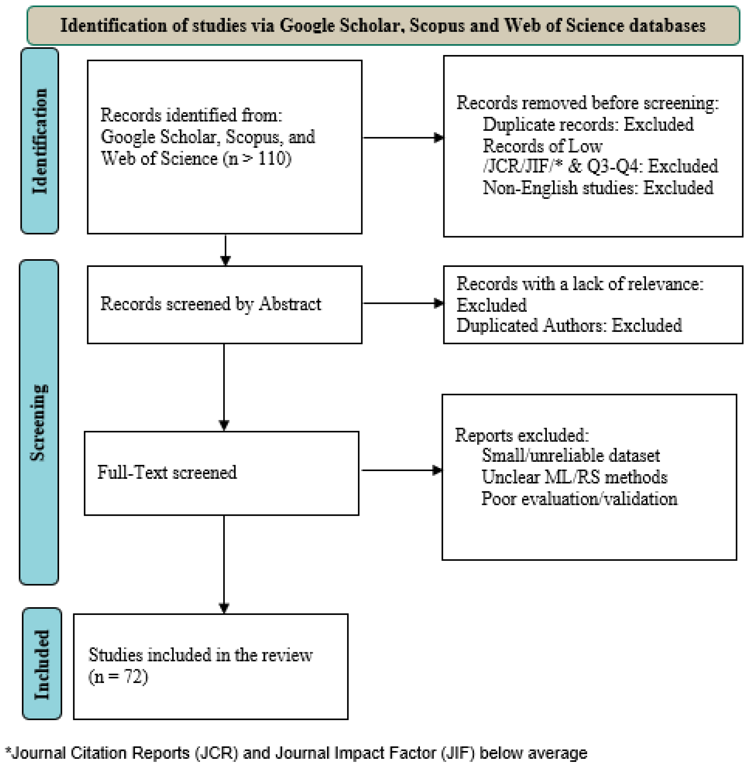
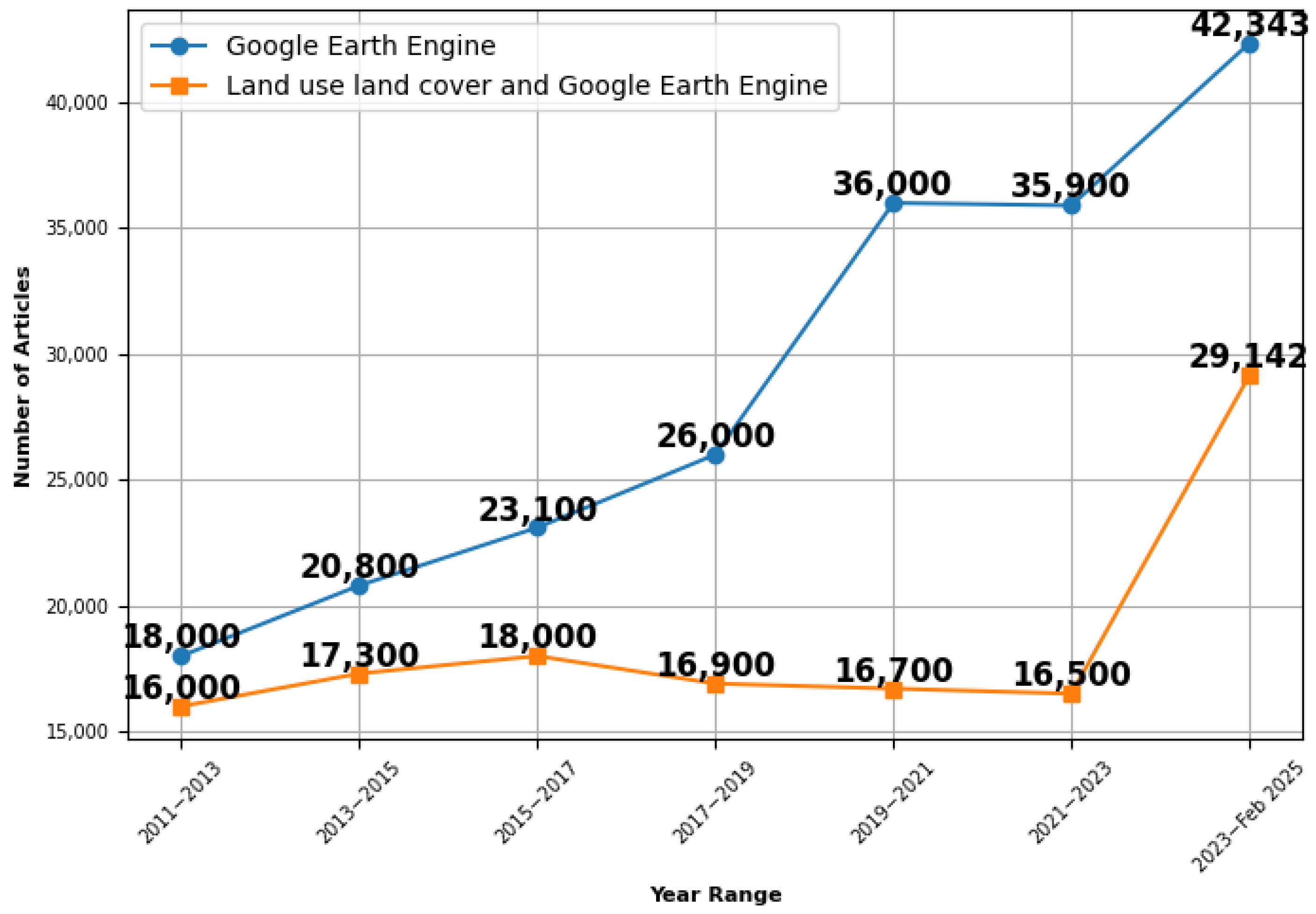

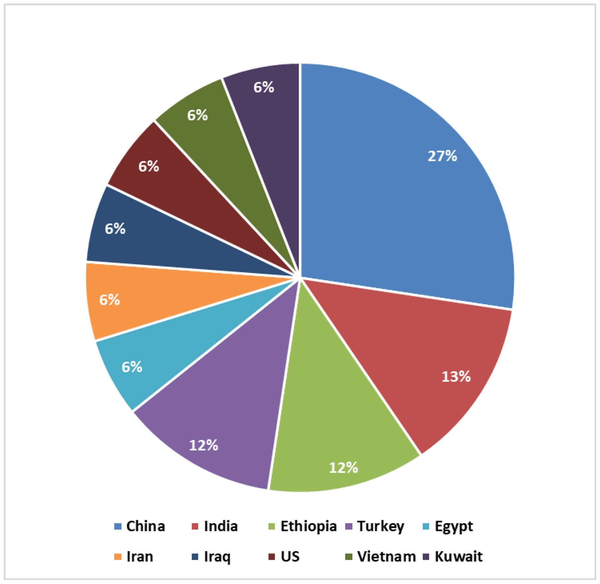
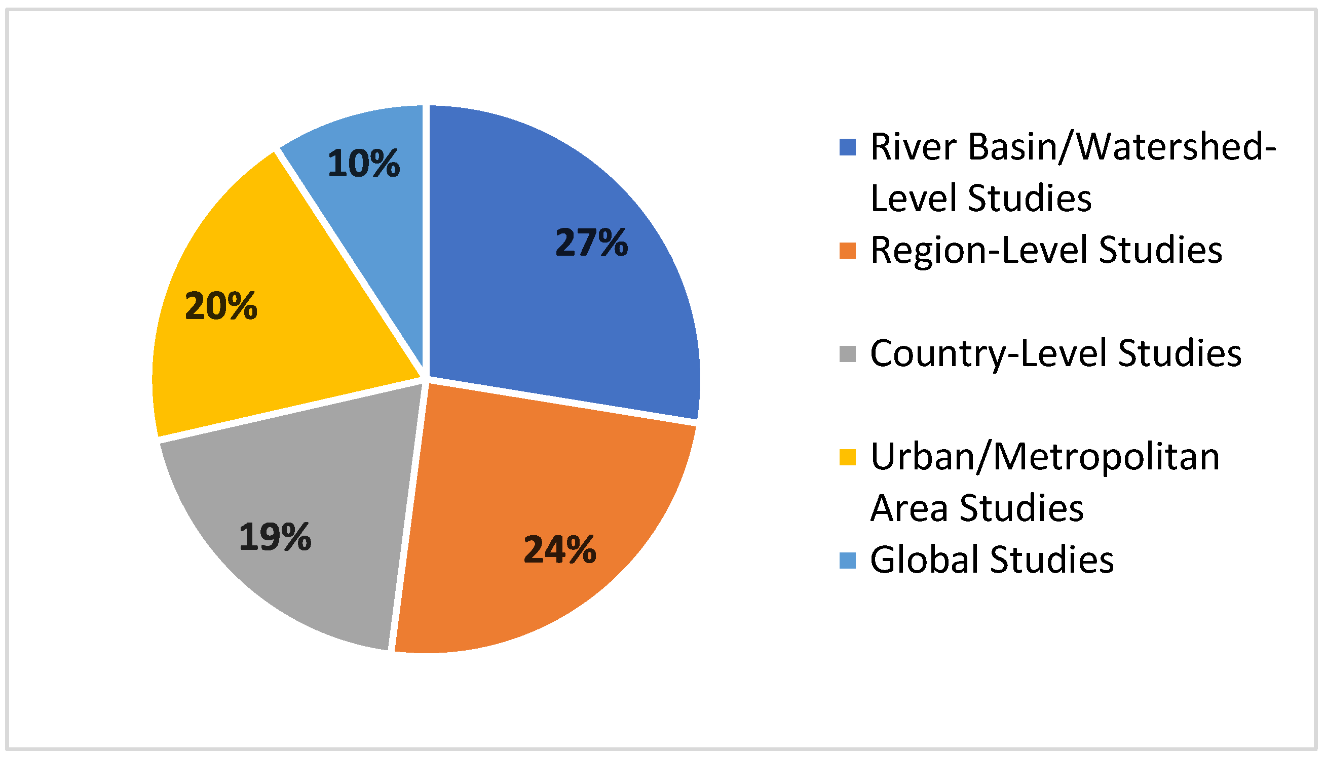
| Feature | Google Earth Engine (GEE) | Amazon Web Services (AWS) | Microsoft Azure |
|---|---|---|---|
| Satellite Imagery Coverage | Landsat, Sentinel, MODIS, NOAA, ALOS, and many others. | Landsat-8, Sentinel-1/2, NOAA, DigitalGlobe, Global Model Outputs. | Landsat & Sentinel-2 (North America), MODIS. |
| Volume of Data | >40 Petabytes of public geospatial datasets, updated daily. | Petabyte-scale of data with access to various remotely sensed datasets. | Multi-petabyte data lake with earth observation access via planetary. |
| AI/ML Tools | Integrated cloud-based AI/ML tools and Application Programming Interfaces (APIs). | Supports AI/ML through cloud infrastructure with fewer domain-specific requirements. | AI/ML capabilities via Azure Machine Learning services. |
| Cost | Free access for researchers and public users. | Paid services, pricing based on usage. | Paid services, pricing based on usage. |
| Historical Archive | Extensive data have been archived, including Landsat data since 1972. | Varies, generally more recent datasets. | MODIS since 2000, Landsat & Sentinel-2 for North America since 2013. |
| Remote Sensing Usability | Built-in APIs (JavaScript, Python), optimized for geospatial data; no local setup required. | Requires setup of compute/storage tiers, such as Amazon Elastic Compute Cloud (EC2) and Amazon S3 Storage tiers, offering strong flexibility but higher technical entry requirements. | Integrated APIs (Python, R) with pre-built packages for planetary data access. |
| Journal Title | No. of Publication | Percentage |
|---|---|---|
| Remote Sensing | 18 | 25% |
| ISPRS Journal of Photogrammetry and Remote Sensing | 5 | 7% |
| ISPRS International Journal of Geo-Information | 4 | 6% |
| Remote Sensing of Environment | 3 | 4% |
| Others | 42 | 58% |
| Total | 72 | 100% |
| Data Source | Percentage | Subcategory | Percentage |
|---|---|---|---|
| Landsat | 65% | Landsat 8 OLI | 31% |
| Landsat 7 ETM+ | 14% | ||
| Landsat 5 TM | 20% | ||
| Sentinel | 23% | Sentinel-2 | 15% |
| Sentinel-1 | 8% | ||
| MODIS | 4.5% | MODIS | 4.5% |
| Other | 7.5% | Gaofen-2, DMSP/OLS, PALSAR, CORINE, etc. | 7.5% |
Disclaimer/Publisher’s Note: The statements, opinions and data contained in all publications are solely those of the individual author(s) and contributor(s) and not of MDPI and/or the editor(s). MDPI and/or the editor(s) disclaim responsibility for any injury to people or property resulting from any ideas, methods, instructions or products referred to in the content. |
© 2025 by the authors. Published by MDPI on behalf of the International Society for Photogrammetry and Remote Sensing. Licensee MDPI, Basel, Switzerland. This article is an open access article distributed under the terms and conditions of the Creative Commons Attribution (CC BY) license (https://creativecommons.org/licenses/by/4.0/).
Share and Cite
Alshehri, B.; Zhang, Z.; Liu, X. A Review of Google Earth Engine for Land Use and Land Cover Change Analysis: Trends, Applications, and Challenges. ISPRS Int. J. Geo-Inf. 2025, 14, 416. https://doi.org/10.3390/ijgi14110416
Alshehri B, Zhang Z, Liu X. A Review of Google Earth Engine for Land Use and Land Cover Change Analysis: Trends, Applications, and Challenges. ISPRS International Journal of Geo-Information. 2025; 14(11):416. https://doi.org/10.3390/ijgi14110416
Chicago/Turabian StyleAlshehri, Bader, Zhenyu Zhang, and Xiaoye Liu. 2025. "A Review of Google Earth Engine for Land Use and Land Cover Change Analysis: Trends, Applications, and Challenges" ISPRS International Journal of Geo-Information 14, no. 11: 416. https://doi.org/10.3390/ijgi14110416
APA StyleAlshehri, B., Zhang, Z., & Liu, X. (2025). A Review of Google Earth Engine for Land Use and Land Cover Change Analysis: Trends, Applications, and Challenges. ISPRS International Journal of Geo-Information, 14(11), 416. https://doi.org/10.3390/ijgi14110416


