
Monitoring and Cause Analysis of Land Subsidence along the Yangtze River Utilizing Time-Series InSAR

Abstract
1. Introduction
2. Research Area and Experimental Data
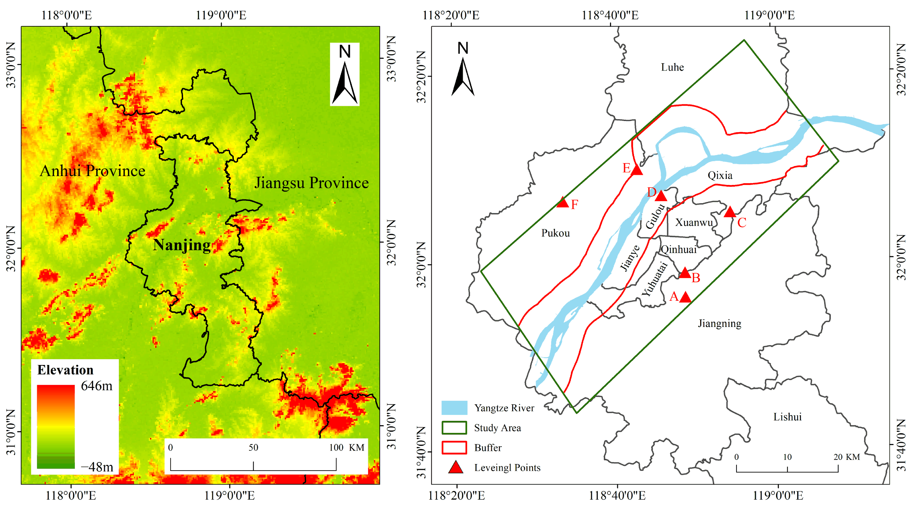
2.1. Research Area
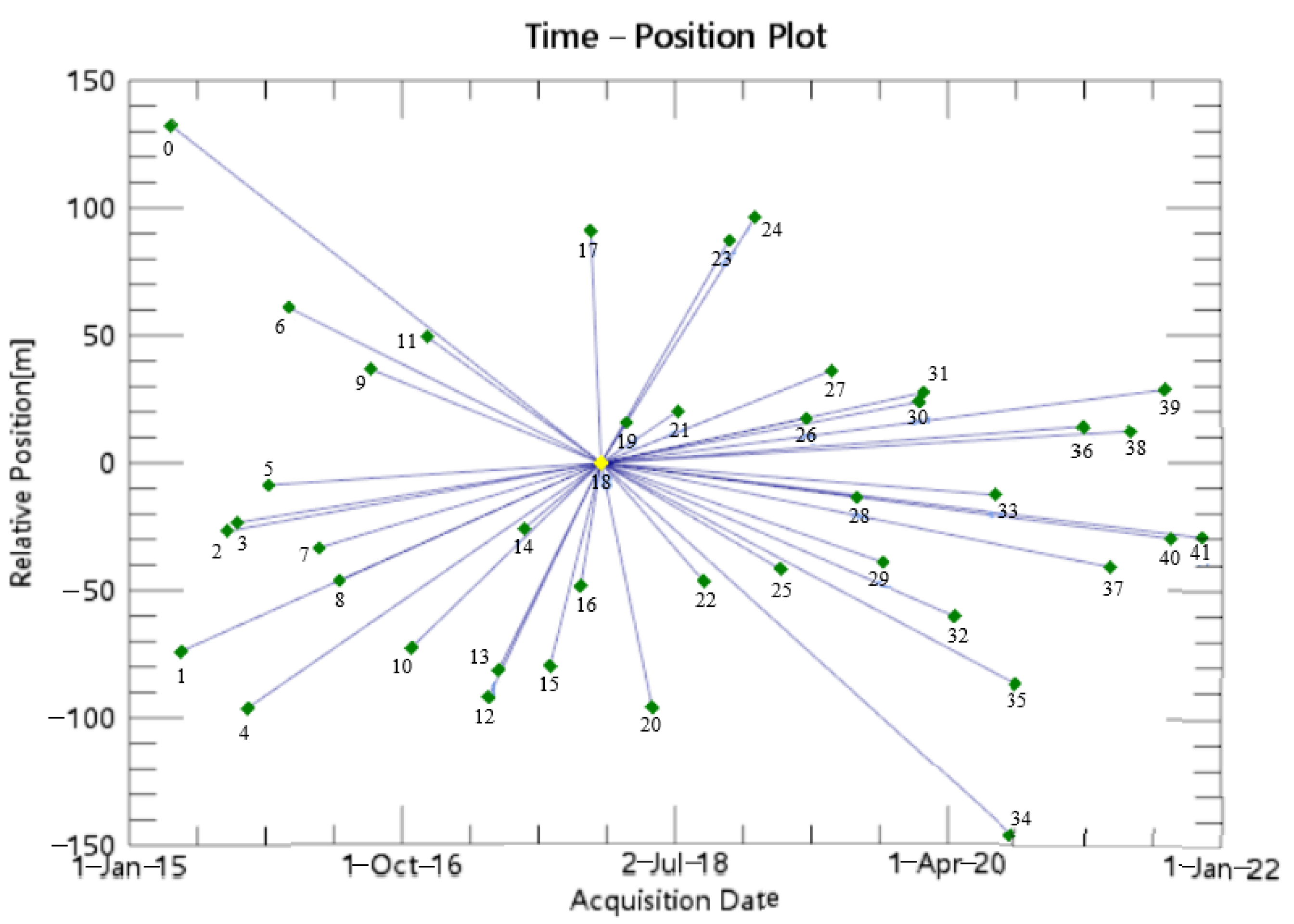
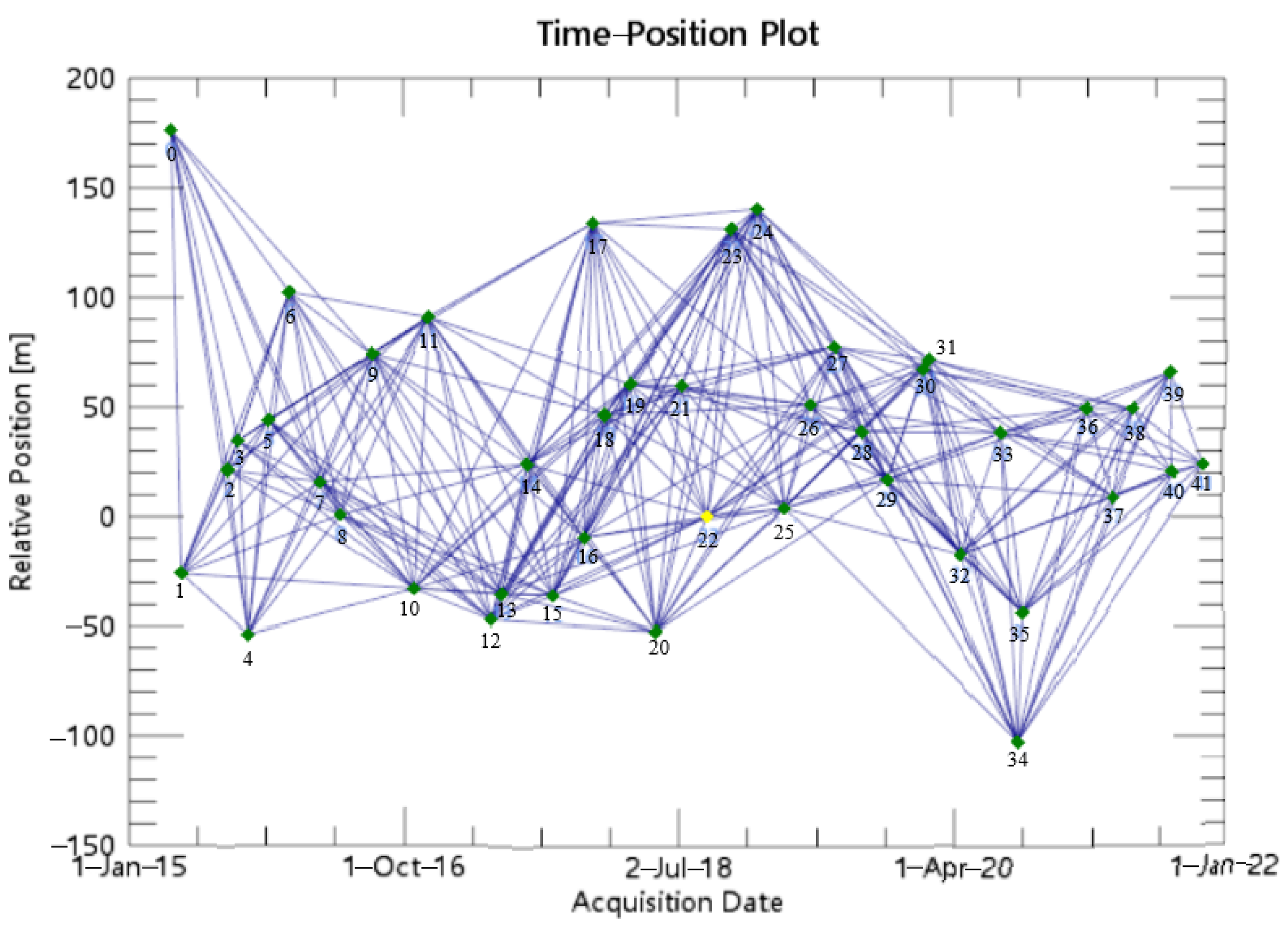
2.2. Experimental Data
3. Technical Principles
3.1. PS-InSAR Technology
3.2. SBAS-InSAR Technology
4. Results Analysis
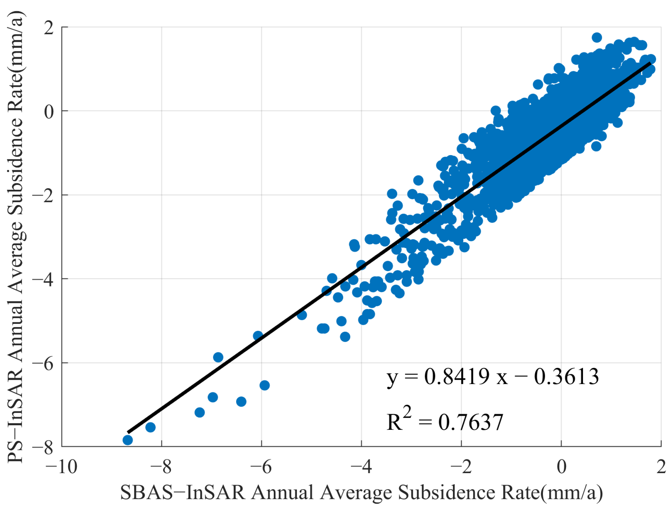
4.1. Comparative Validation of PS-InSAR and SBAS-InSAR Monitoring Results
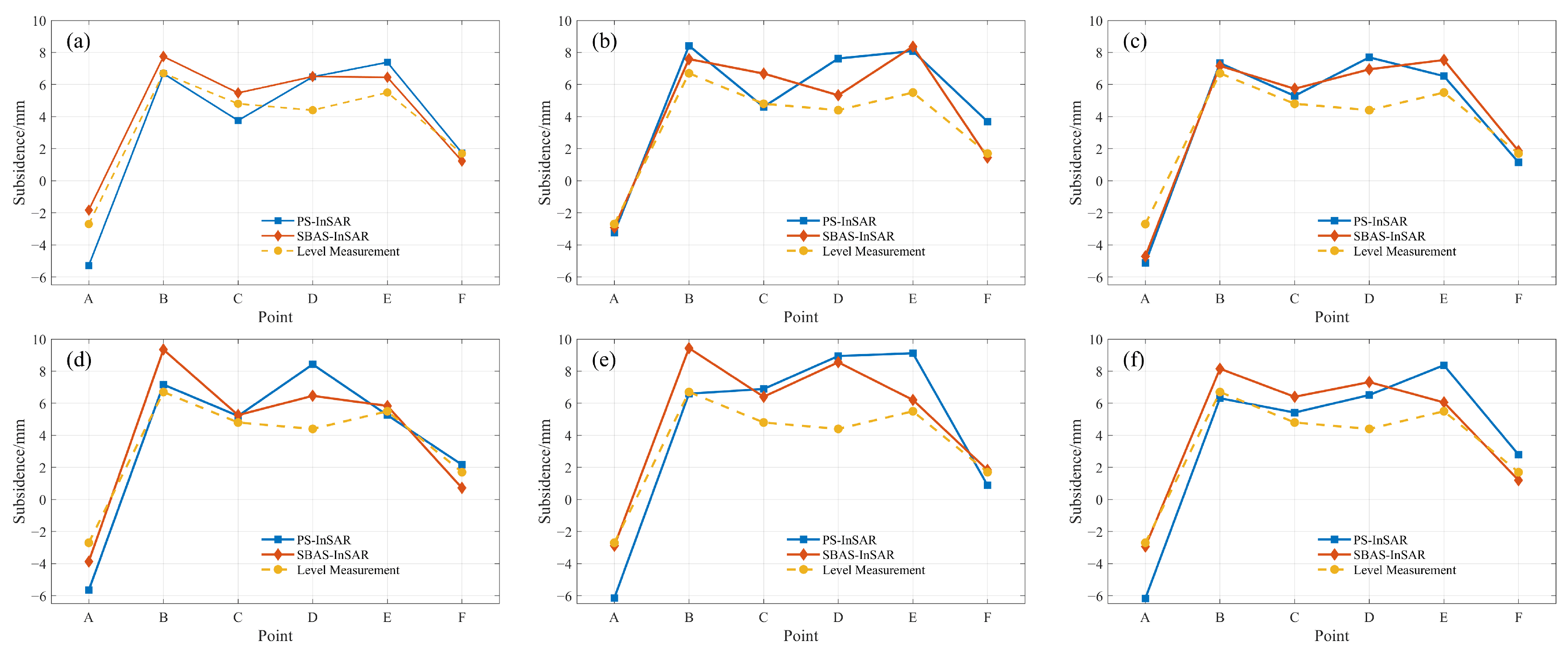
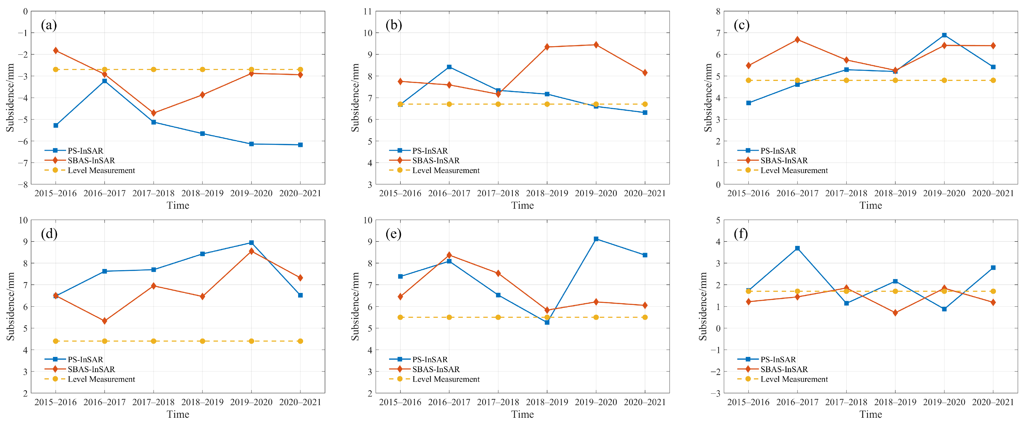
4.2. Accuracy Verification of Monitoring Results Based on Leveling Data
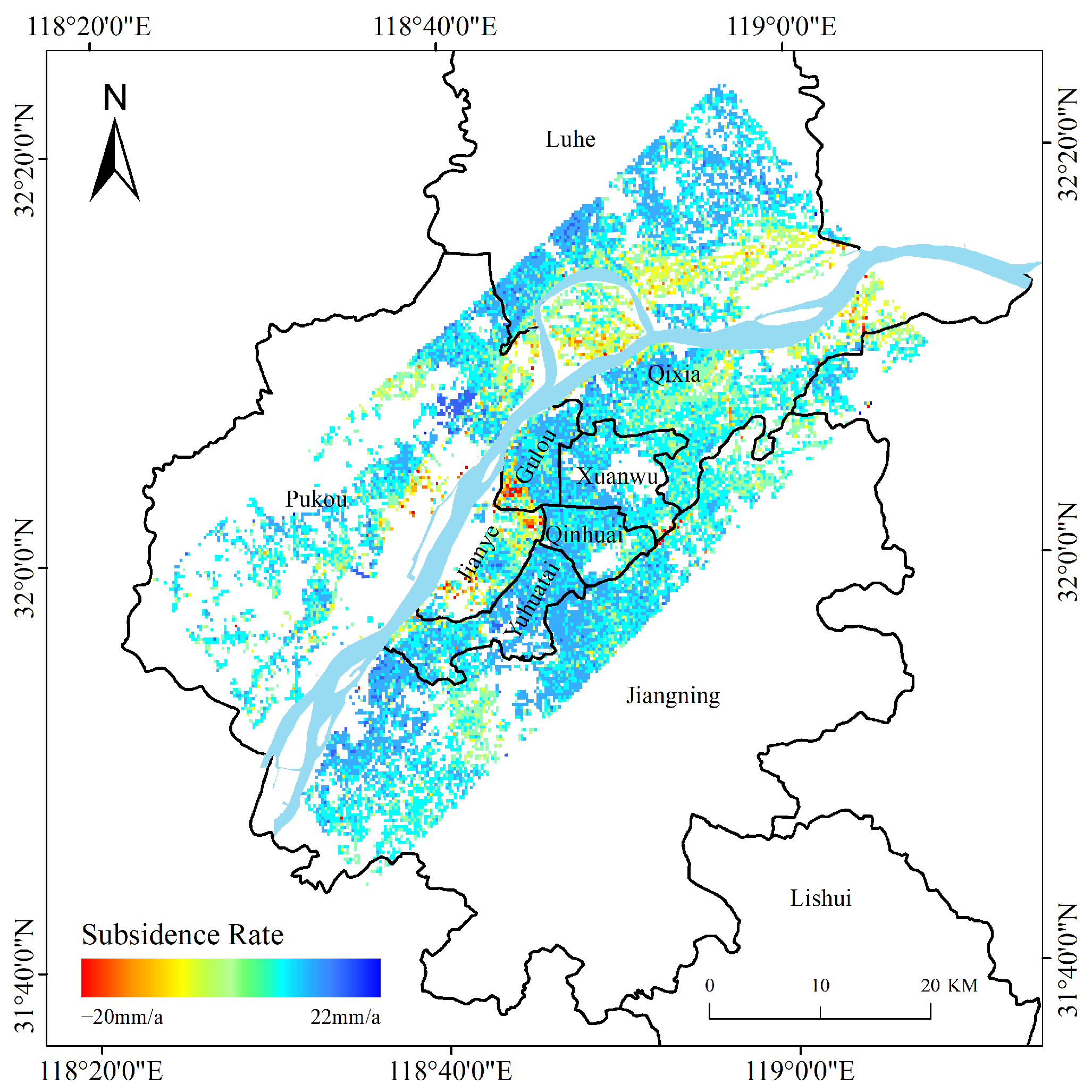
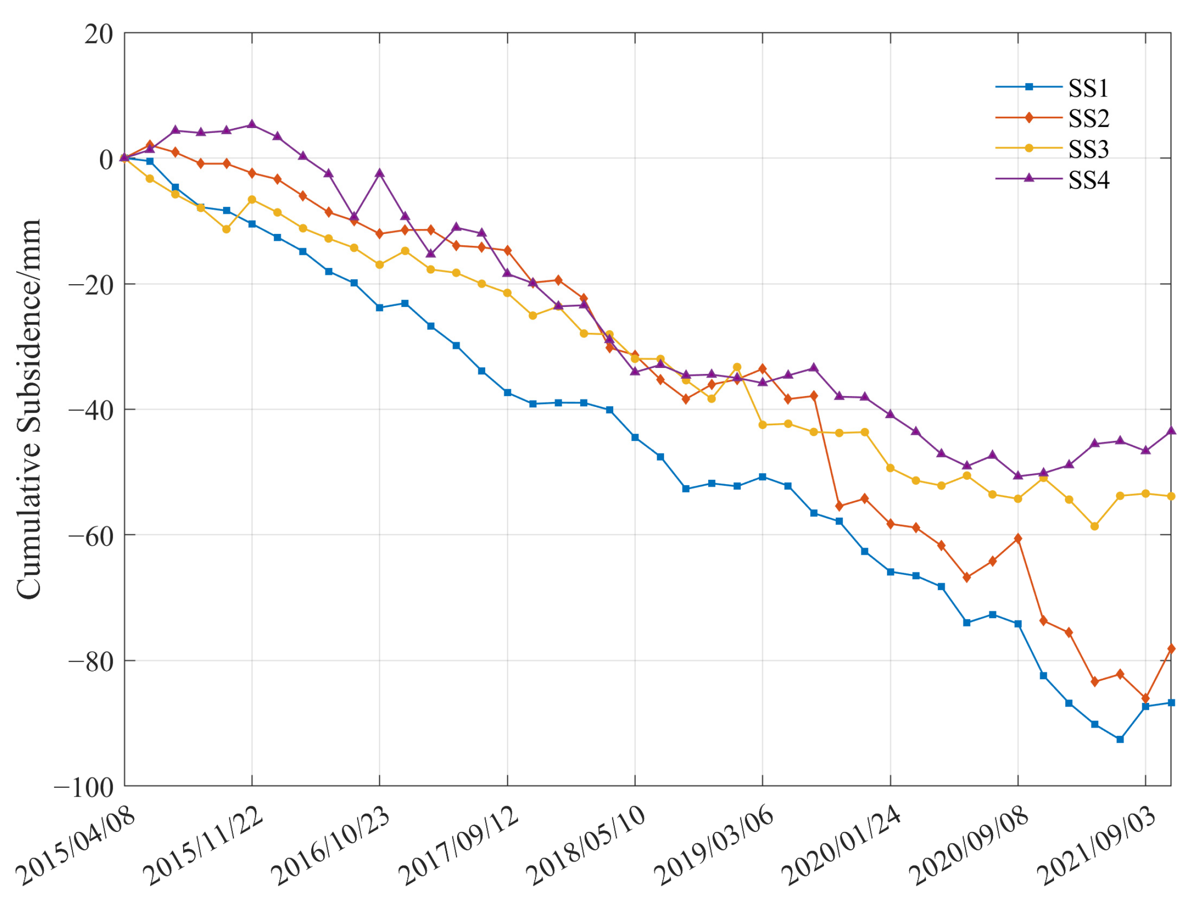
4.3. Analysis of Spatiotemporal Variation Characteristics of Land Subsidence
5. Discussion of the Factors Related to Land Subsidence along the Yangtze River in Nanjing
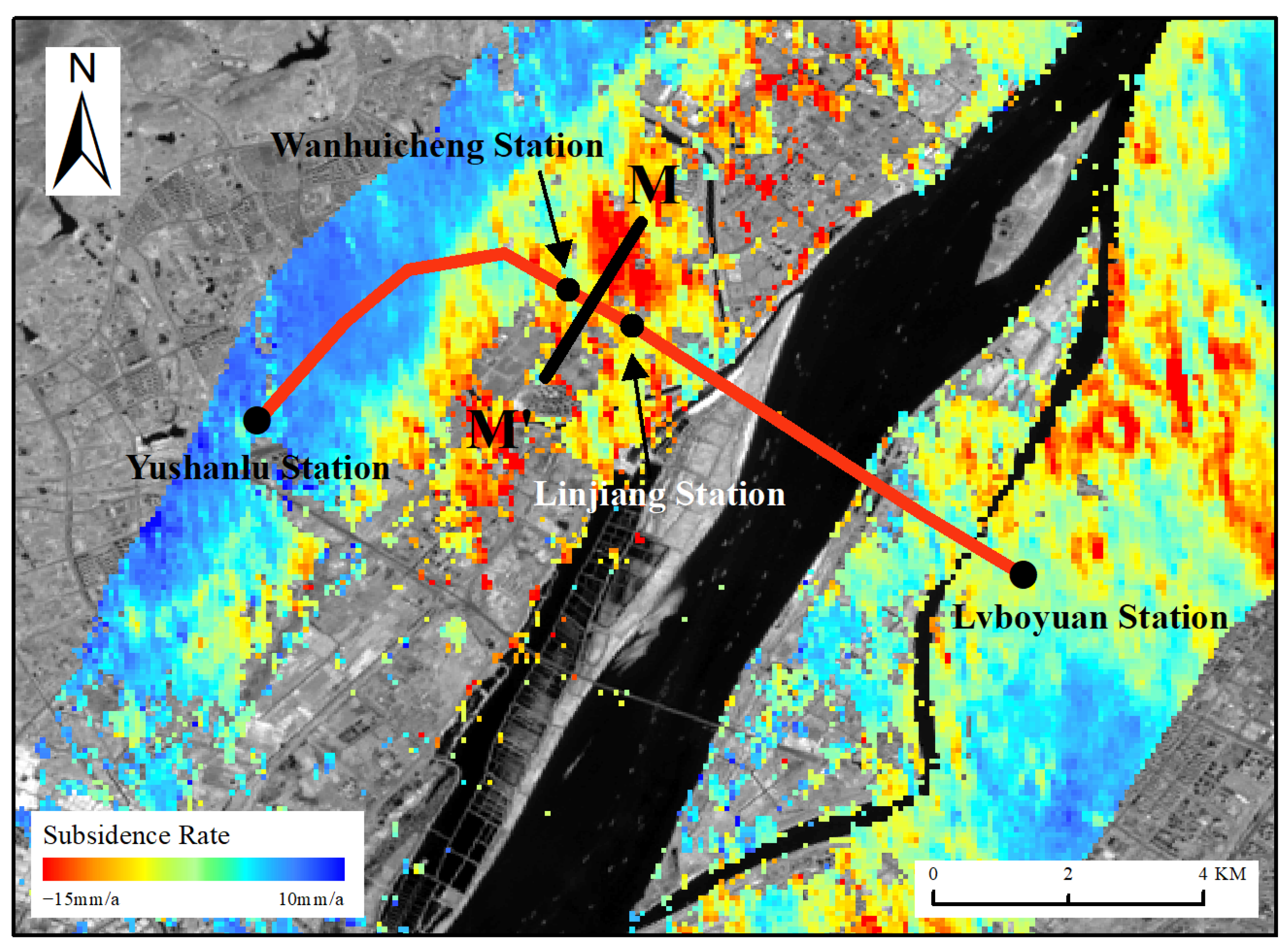
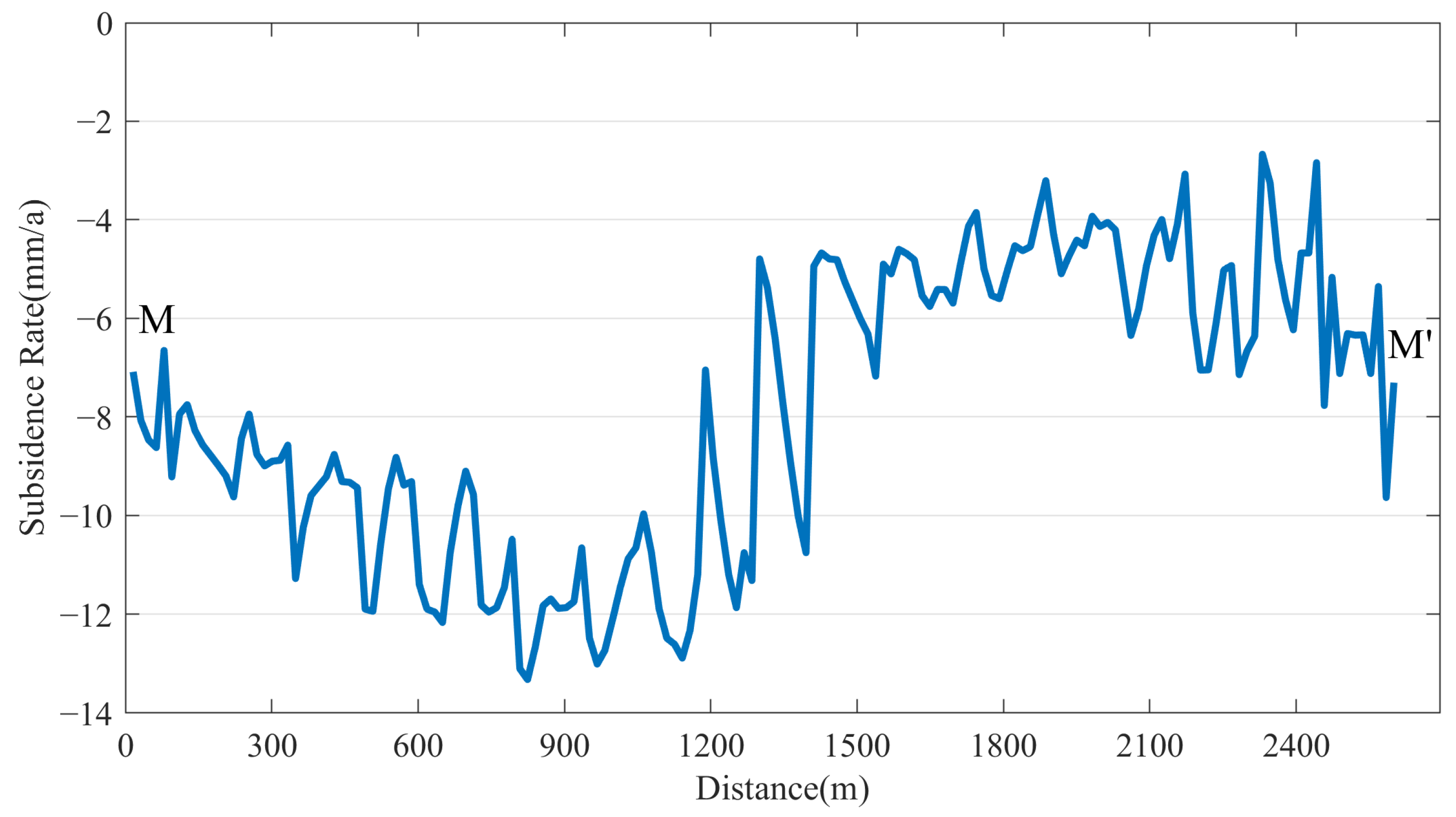
5.1. The Influence of Underground Engineering on Land Subsidence
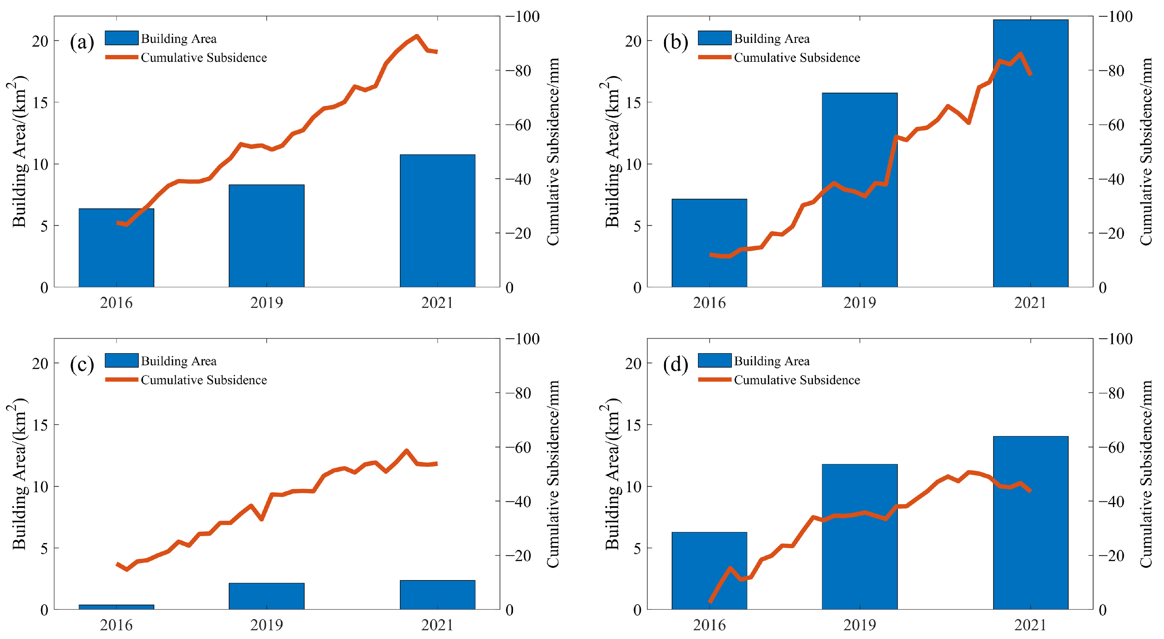
5.2. The Relationship between Ground Building Area and Land Subsidence
5.3. The Influence of Geological Structure on Land Subsidence
6. Conclusions
- (1)
- The ground deformation along the Yangtze River in Nanjing extracted by PS-InSAR and SBAS-InSAR technologies was consistent, and the two monitoring results had a high correlation with the leveling results. The maximum deviation of deformation didn’t exceed ±5 mm, which was reliable in accuracy.
- (2)
- The key areas within 5 km on both sides of the Yangtze River were analyzed. It was found that there were four subsidence funnels from 2015 to 2011, which were distributed in Jianye District and the southwest of Gulou District, the eastern riverside area of Pukou District, the Baguazhou area, and the Longtan Street in the eastern part of Qixia District, respectively. The subsidence in Jianye District was the most severe, and there was a trend of gradually connecting into a large subsidence funnel. The maximum LOS cumulative subsidence of Jianye district was −86.7 mm. The subsidence area along the river in Dingshan Street of Pukou District was the largest subsidence funnel in the study area. The maximum LOS cumulative subsidence reached −78.1 mm.
- (3)
- The land subsidence along the Yangtze River has a certain correlation with the increasing of the ground building area, the construction and operation of some underground engineering such as subway stations, and the geological conditions of the region, but the contribution of each factor to the subsidence needs to be further analyzed in future studies.
Author Contributions
Funding
Data Availability Statement
Acknowledgments
Conflicts of Interest
References
- Na, T.; Kawamura, Y.; Kang, S.S.; Utsuki, S. Hazard mapping of ground subsidence in east area of Sapporo using frequency ratio model and GIS. Geomat. Nat. Hazards Risk 2021, 12, 347–362. [Google Scholar] [CrossRef]
- Bagheri-Gavkosh, M.; Hosseini, S.M.; Ataie-Ashtiani, B.; Sohani, Y.; Ebrahimian, H.; Morovat, F.; Ashrafi, S. Land subsidence: A global challenge. Sci. Total Environ. 2021, 778, 146193. [Google Scholar] [CrossRef] [PubMed]
- Ding, X.L.; Liu, G.X.; Li, Z.L.; Li, Z.; Chen, Y.Q. Ground subsidence monitoring in Hong Kong with satellite SAR interferometry. Photogramm. Eng. Remote Sens. 2004, 70, 1151–1156. [Google Scholar] [CrossRef]
- Yalçınkaya, M. Monitoring crustal movements in west Anatolia by precision leveling. J. Surv. Eng. 2003, 129, 44–49. [Google Scholar] [CrossRef]
- Nestorović, Ž.; Delčev, S. Comparison of height differences obtained by trigonometric and spirit leveling method. Geonauka 2014, 2, 30–37. [Google Scholar] [CrossRef]
- Yang, D.L.; Zou, J.; Shen, Y.W.; Zhu, H. Research and application of trigonometric leveling to replace precise leveling. J. Surv. Eng. 2021, 147, 04021012. [Google Scholar]
- Xiang, Y.F.; Wang, H.; Chen, Y.Y.; Xing, Y. GNSS imaging of strain rate changes and vertical crustal motions over the Tibetan Plateau. Remote Sens. 2021, 13, 4937. [Google Scholar] [CrossRef]
- Xiang, Y.F.; Yue, J.P.; Liu, G.; Chen, Y.Y. Characterizing the spatial patterns of vertical crustal deformations over the South American continent based on GNSS imaging. Pure Appl. Geophys. 2022, 79, 3569–3587. [Google Scholar] [CrossRef]
- Zhu, J.J.; Li, Z.W.; Hu, W.J. Research progress and methods of InSAR for deformation monitoring. Acta Geod. Cartogr. Sin. 2017, 46, 1717–1733. [Google Scholar]
- Wang, Y.; Feng, G.; Li, Z.; Luo, S.; Wang, H.; Xiong, Z.; Zhu, J.; Hu, J. A strategy for variable-scale InSAR deformation monitoring in a wide area: A case study in the Turpan–Hami Basin, China. Remote Sens. 2022, 14, 3832. [Google Scholar] [CrossRef]
- Wang, Z.; Dai, H.; Yan, Y.; Ren, J.; Zhang, Y.; Liu, J. An InSAR deformation phase retrieval method combined with reference phase in mining areas. Remote Sens. 2023, 15, 4573. [Google Scholar] [CrossRef]
- Feng, Y.; Zhou, Y.; Chen, Y.; Li, P.; Xi, M.; Tong, X. Automatic selection of permanent scatterers-based GCPs for refinement and reflattening in InSAR DEM generation. Int. J. Digit. Earth 2022, 15, 954–974. [Google Scholar] [CrossRef]
- Fan, H.; Deng, K.; Ju, C.; Zhu, C.; Xue, J. Land subsidence monitoring by D-InSAR technique. Min. Sci. Technol. 2011, 21, 869–872. [Google Scholar] [CrossRef]
- Fan, H.; Wei, G.; Yong, Q.; Xue, J.; Chen, B. A model for extracting large deformation mining subsidence using D-InSAR technique and probability integral method. Trans. Nonferrous Met. Soc. 2014, 24, 1242–1247. [Google Scholar] [CrossRef]
- Chen, Y.; Yu, S.; Tao, Q.; Liu, G.; Wang, L.; Wang, F. Accuracy verification and correction of D-InSAR and SBAS-InSAR in monitoring mining surface subsidence. Remote Sens. 2021, 13, 4365. [Google Scholar] [CrossRef]
- Wang, L.; Deng, K.; Zheng, M. Research on ground deformation monitoring method in mining areas using the probability integral model fusion D-InSAR, sub-band InSAR and offset-tracking. Int. J. Appl. Earth Obs. 2020, 85, 101981. [Google Scholar] [CrossRef]
- Ferretti, A.; Prati, C.; Rocca, F. Analysis of permanent scatterers in SAR interferometry. In Proceedings of the IEEE 2000 International Geoscience and Remote Sensing Symposium, Honolulu, HI, USA, 24–28 July 2000; pp. 761–763. [Google Scholar]
- Ferretti, A.; Prati, C.; Rocca, F. Permanent scatterers in SAR interferometry. IEEE Trans. Geosci. Remote Sens. 2001, 39, 8–20. [Google Scholar] [CrossRef]
- Berardino, P.; Fornaro, G.; Lanari, R.; Sansosti, E. A new algorithm for surface deformation monitoring based on small baseline differential SAR interferograms. IEEE Trans. Geosci. Remote Sens. 2002, 40, 2375–2383. [Google Scholar] [CrossRef]
- Boloorani, A.D.; Darvishi, M.; Weng, Q.; Liu, X. Post-war urban damage map** using InSAR: The case of Mosul City in Iraq. ISPRS Int. J. Geo-Inf. 2021, 10, 140. [Google Scholar] [CrossRef]
- Joshi, M.; Kothyari, G.C.; Kotlia, B.S. Landslide detection in Kinnaur Valley, NW India using PS-InSAR technique. Phys. Geogr. 2024, 45, 160–174. [Google Scholar] [CrossRef]
- Liu, J.; Li, T.; Ma, S.; Shan, Q.; Jiang, W. Study on LOS to Vertical Deformation Conversion Model on Embankment Slopes Using Multi-Satellite SAR Interferometry. ISPRS Int. J. Geo-Inf. 2024, 13, 58. [Google Scholar] [CrossRef]
- Welikanna, D.R.; Jin, S.Y. Investigating ground deformation due to a series of collapse earthquakes by means of the PS-InSAR technique and Sentinel 1 data in Kandy, Sri Lanka. J. Appl. Remote Sens. 2023, 17, 014507. [Google Scholar] [CrossRef]
- Zhang, P.; Guo, Z.; Guo, S.; Guo, S.; Xia, J. Land subsidence monitoring method in regions of variable radar reflection characteristics by integrating PS-InSAR and SBAS-InSAR techniques. Remote Sens. 2022, 14, 3265. [Google Scholar] [CrossRef]
- Malik, K.; Kumar, D.; Perissin, D.; Pradhan, B. Estimation of ground subsidence of New Delhi, India using PS-InSAR technique and Multi-sensor Radar data. Adv. Space Res. 2022, 69, 1863–1882. [Google Scholar] [CrossRef]
- Bahti, F.N.; Chung, C.C.; Lin, C.C. Parametric Test of the Sentinel 1A Persistent scatterer-and small baseline subset-interferogram Synthetic Aperture Radar processing using the stanford method for persistent scatterers for practical landslide monitoring. Remote Sens. 2023, 15, 4662. [Google Scholar] [CrossRef]
- Cao, Y.; Li, P.; Hao, D.; Lian, Y.; Wang, Y.; Zhao, S. Analysis of the relationship between vegetation and radar interferometric coherence. Sustainability 2022, 14, 16471. [Google Scholar] [CrossRef]
- Krystek, M.; Anton, M. A weighted total least-squares algorithm for fitting a straight line. Meas. Sci. Technol. 2007, 8, 3438. [Google Scholar] [CrossRef]
- Xu, Y.; Ma, L.; Du, Y.; Shen, S. Analysis of urbanisation-induced land subsidence in Shanghai. Nat. Hazards 2012, 63, 1255–1267. [Google Scholar] [CrossRef]
- Cui, Z.; Yang, J.; Yuan, L. Land subsidence caused by the interaction of high-rise buildings in soft soil areas. Nat. Hazards 2015, 79, 1199–1217. [Google Scholar] [CrossRef]
- Yang, Q.; Ke, Y.; Zhang, D.; Chen, B.; Gong, H.; Lv, M.; Zhu, L.; Li, X. Multi-scale analysis of the relationship between land subsidence and buildings: A case study in an eastern Beijing urban area using the PS-InSAR technique. Remote Sens. 2018, 10, 1006. [Google Scholar] [CrossRef]
- Karanam, H.K.; Neela, V.B. Study of normalized difference built-up (NDBI) index in automatically mapping urban areas from Landsat TN imagery. Int. J. Eng. Sci. Math. 2017, 8, 239–248. [Google Scholar]
- Saito, Y.; Yang, Z.S.; Hori, K. The Huanghe (Yellow River) and Changjiang (Yangtze River) deltas: A review on their characteristics, evolution and sediment discharge during the Holocene. Geomorphology 2001, 41, 219–231. [Google Scholar] [CrossRef]


| Soil Layer | Characteristic |
|---|---|
| Surface recent and outdated fill | Mainly composed of building residue and cultivated soil, which is soft and has strong plasticity |
| Marsh facies with mucky and silty clay | Pure without sand, showing grayish-brown |
| Floodplain facies with muddy, silty clay and silt sand interbedding | With horizontal bedding and grey colors |
| Riverbed facies with medium-coarse gravel sand, coarse gravel sand mixed with gravel or boulders | Compactness increases with depth from loose to dense |
Disclaimer/Publisher’s Note: The statements, opinions and data contained in all publications are solely those of the individual author(s) and contributor(s) and not of MDPI and/or the editor(s). MDPI and/or the editor(s) disclaim responsibility for any injury to people or property resulting from any ideas, methods, instructions or products referred to in the content. |
© 2024 by the authors. Licensee MDPI, Basel, Switzerland. This article is an open access article distributed under the terms and conditions of the Creative Commons Attribution (CC BY) license (https://creativecommons.org/licenses/by/4.0/).
Share and Cite
Chen, Y.; Guo, L.; Xu, J.; Yang, Q.; Wang, H.; Zhu, C. Monitoring and Cause Analysis of Land Subsidence along the Yangtze River Utilizing Time-Series InSAR. ISPRS Int. J. Geo-Inf. 2024, 13, 230. https://doi.org/10.3390/ijgi13070230
Chen Y, Guo L, Xu J, Yang Q, Wang H, Zhu C. Monitoring and Cause Analysis of Land Subsidence along the Yangtze River Utilizing Time-Series InSAR. ISPRS International Journal of Geo-Information. 2024; 13(7):230. https://doi.org/10.3390/ijgi13070230
Chicago/Turabian StyleChen, Yuanyuan, Lin Guo, Jia Xu, Qiang Yang, Hao Wang, and Chenwei Zhu. 2024. "Monitoring and Cause Analysis of Land Subsidence along the Yangtze River Utilizing Time-Series InSAR" ISPRS International Journal of Geo-Information 13, no. 7: 230. https://doi.org/10.3390/ijgi13070230
APA StyleChen, Y., Guo, L., Xu, J., Yang, Q., Wang, H., & Zhu, C. (2024). Monitoring and Cause Analysis of Land Subsidence along the Yangtze River Utilizing Time-Series InSAR. ISPRS International Journal of Geo-Information, 13(7), 230. https://doi.org/10.3390/ijgi13070230