Article

Mining Geomatics

Department of Mine Areas Protection, Geoinformatics and Mine Surveying, Faculty of Geo-Data Science, Geodesy, and Environmental Engineering, AGH University of Krakow, 30-059 Kraków, Poland
ISPRS Int. J. Geo-Inf. 2023, 12(7), 278; https://doi.org/10.3390/ijgi12070278
Submission received: 20 May 2023 / Revised: 3 July 2023 / Accepted: 11 July 2023 / Published: 14 July 2023

Abstract

:
This paper attempts to define a name for an area of science and technology that encompasses the acquisition, processing and application of spatial data in the mining industry. A comparative study of the evolution of spatial data exchange methods between Geographic Information Systems (GISs) and General Mining Planning (GMP) software is carried out to define the problem and name it. Subsequent modifications of the acronym GIS towards the specialisation of its application in mining are then reviewed. This is followed by the identification of three terminological postulates designed to formulate constraints and rules for the creation of a new definition. The subsequent analysis identifies the nomenclatural basis of the research area of geomatics and determines its applicability in the context of mining. The results of the research made it possible to formulate a new definition of “mining geomatics”. The final section of the article presents an initial proposal for an inventory of the basic concepts of mining geomatics in the form of a Body of Knowledge for mining geomatics.

1. Introduction

Nowadays, the mineral mining industry is increasingly acquiring spatial data using modern survey platforms such as satellites or unmanned aerial vehicles (UAVs), which perform measurements using active and passive remote sensing technologies [1]. The most common applications of terrestrial laser scanning are for the purposes of inventorying the infrastructure of mine workings [2,3,4], measuring the volume of workings and heaps in underground and open-pit mining operations [5,6,7]. Mobile laser scanning is used to collect information on the location of mine workings equipment [8,9]. Aerial laser scanning, on the other hand, has found application for measuring changes in topographical relief within the boundaries of mining areas [10]. Infrared remote sensing should also be mentioned, which allows the monitoring of waste heaps in coal mining [11]. Other sources of data are measurements made using radar techniques. Using ground-based radar interferometry [12], it is possible to carry out tilt measurements of, for example, a shaft tower or for observing slope stability in open-pit mining [13]. Satellite-based interferometric synthetic aperture radar (InSAR) interferometry has also been widely used in the mining industry [14,15] to measure ground deformation [16]. In the following years, methods were developed to analyse a series of interferometric data called persistent scatterers interferometry synthetic aperture radar (PSInSAR) [17]. A few years later, another method was developed called corner reflector interferometry synthetic aperture radar (CRInSAR) [18], requiring the construction of ground-based angle reflectors particularly useful in open-pit mining for monitoring open-pit slopes and waste tailing embankments.
Equally attractive tools for data acquisition are UAV platforms, which are increasingly used in mining [19,20]. One of the primary methods for analysing data collected by UAV cameras is the structure from motions (SfMs) method, which has found many applications in geoscience [21]. It is a much cheaper method than laser scanning and allows spatial models to be obtained along with textures with the desired accuracy.
Another measurement technology used in mining is measurements using global navigation satellite system (GNSS) satellite techniques [22]. They are widely used to measure the deformation of mining areas [23] and slope gradients of open-pit workings [24]. These systems are also used to determine the localization and operating status of machinery and equipment in open-pit mining, in particular, for the location of mining equipment in a pit [25]. This applies to both manned and unmanned machinery [26].
Data in the form of a series of images taken with a UAV allow spatial models of opencast pits to be created. These types of models can be transferred to a Geographic Information System (GIS) environment [27] where advanced spatial analyses can be performed [28]. However, data of these types can also be analysed in computer systems dedicated to mining called General Mining Planning software (GMPs) or Mining Planning Software (MPS) [29]. Many of these systems have already had modules designed to process and analyse new types of data for many years. MAPTEK software’s I-Site module can just as efficiently process and analyse laser scanning data as it can a point cloud from images taken with a UAV platform [30].
This raises the question of whether it is the subject that defines the field of application of different technologies for its analysis, or whether it is perhaps the application of the technology that defines the processed data in its field. If the technology defines the research area, then we have situations where the same data imported into different systems become different types of data—“gis data” or “mining data”. This is an inadvisable situation where the research tool dominates the research domain, and such an approach can now be considered commonplace. This is confirmed by the analysis of two articles that deal with the analysis of spatial data tools in mining.
This article [31] presents the results of an analysis of 58 scientific articles on the use of GIS technologies for spatial data processing in mining. As a result of this analysis, stages of mining operations in which GIS technologies in mining are increasingly being applied were identified, and these are, according to the authors, mine planning, design support for transport operations and environmental protection in mining. By far the largest number of articles have dealt with GIS applications in environmental protection and infrastructure.
On the other hand, a project was launched in South Africa in 2013 to collect data on the software used in mining. The information was collected in order to compare selected features of this software. The results of the questionnaires completed by mine employees were recorded in a database accessible to them on the Internet [32]. The work resulted in the identification of 40 different systems or individual modules used at different stages of planning the design and conduct of mining operations. None of these systems were GIS-type systems. This means that GIS was not seen as a viable working tool by the staff of the technical departments of the mines, and was not used in the day-to-day work of the technical departments of the mines. Of course, a difference of 7 years between the two articles must be taken into account. However, a clear divide can be seen between the use and description of the applications of these technologies in mining. This situation can be summarised as follows: 7 years ago, miners did not use GIS in their work, in contrast to scientists working for the mining industry, who very often now use GIS for mining analysis.
This situation raises the question: does technology dominate the subject of research and analysis, which is mining? Or is mining the entity of the use of various IT technologies for spatial data acquisition and processing? To obtain an answer, it is first necessary to compare GIS and GMP technologies using a specific criterion. It is also essential to review the definitions of concepts related to spatial data processing in mining. Finally, the reasons for the similarities and differences should be identified and valorised, which will be the basis for defining and naming the area of application of spatial analyses in mining.

2. Materials and Methods Used in Research

In the field of mining, spatial data data acquisition, sharing and processing are carried out by means of increasingly diverse information technologies. These are not always systems developed directly for the mining industry but adopted from other fields, for example, GIS. The mining industry is also making increasing use of modern measurement systems, which were previously developed for other disciplines. This situation results in ambiguity in defining terms related to the use of new information technologies and new data sources. Therefore, an analysis of this phenomenon was undertaken in order to define and systematise it.
In the first part, a study of the information technologies used to process spatial data was carried out. Taking into account the time factor, a comparison was made between selected GMP and GIS systems at different stages of their development. This was followed by a presentation of how these systems and their spatial data storage structures have changed over time. This made it possible to estimate the direction of change in GIS and GMP technologies over the last 30 years. In the second part, three analyses were conducted based on a review of the available scientific literature. The first analysis reviewed attempts to create and popularise acronyms related to the use of the acronym GIS in mining. The second analysis was conducted using the method of terminological association analysis comparing the occurrence of selected mining and geomatics terms in the scientific literature. To date, these types of issues in the context of defining an area of knowledge and skills in spatial data processing in mining have not been analysed.

2.1. Comparative Analysis of GIS and GMP Technologies

Due to the fact that, from the point of view of implementing computer systems into mining, the most important resource is data, the handling of mining data should be used as a criterion for comparison. Another factor to be taken into account in the comparison is the passage of time. Computer systems are evolving and use increasingly more modern data storage and processing technologies. The publication in [33] presents the history of specialised software development for mining. It identifies the phases of its development and identifies the basis of technological features such as graphics editors, descriptive (text) data recordings and system types. A total of 15 GMP systems were analysed. In a second publication [34], an analysis of the development of GIS software is presented, also by phase of development, together with an indication of changes in the relevant technological features of the software over time. Both of these analyses make it possible to correlate the development paths of these two different technologies over time in terms of spatial data exchange capabilities.
The first of the two systems to be compared is the MINEX system, one of the world’s first comprehensive GMP systems. It was designed for modelling in-seam mineral deposits. The second system, which was one of the world’s first GIS-class technologies, was a system from ESRI called Arc/Info. Both systems originated in the 1970s and 1980s. At the time, they were benchmark systems for other systems due to their level of technological advancement. The first task to undertake is to compare the databases of these two systems. The MINEX database consisted of five interrelated files. The files had extensions from *.B31 to *.B34, and they were binary files containing data from geological boreholes and geological surfaces supplemented with *. tr5 format files representing surfaces described by a triangle grid. It was a file database.
The Arc/Info system stored arc geometry. The name symbolised the combination of the word “Arc” meaning arc (curvilinear geometry of polygons) with the word “Info” (meaning database of polygon attributes). At that time, an information layer (a dataset of an object type) occupied one directory and consisted, at its maximum version, of as many as 23 files managed by the application to serve only one layer of selected geometry [35]. Among these files was one of type *.dbf containing the descriptive attributes of the geometric elements, which was recorded in the “Info” database. Such a large number of files was needed to record information about the vector geometry describing a single dataset with attributes and stored on disk including the topology graph. We can categorise both systems as “monolithic”, closed systems, characterised by the absence of data exchange. There were no data exchange files of any kind, nor database sharing. To transfer data between systems, data had to be exported, reformatted and then imported or entered manually. These systems had individual original graphical interface solutions and their own original databases. They were completely separate systems—“coming from other planets”.
Problems with data exchange were recognised as early as the 1990s and affected various types of applications. These years saw the emergence of geomechanical calculation software (stress analysis software), the application of which in mining required the acquisition of data from monolithic systems for mining. Problems with the exchange of data between these systems formed the basis of the scientific article in [36]. On the other hand, GIS software, initially intended for geography and environmental protection, very quickly found application in Earth sciences [37].
Between 1996 and 2005, there was a radical change in software development in computer science. The procedural programming paradigm was replaced by the analysis, design and object-oriented programming paradigm. This influenced a change in software development technology. Another major change was the introduction of a new data type in relational databases—Binary Large OBject (BLOB). This data type has found application, among other things, in the storage of spatial data. GIS software companies are gradually moving their data storage systems from file-based systems to relational database systems.
In the second stage, the next pair to be compared is MICROMINE software from the MICROMINE company and software from the ESRI company called ArcGIS. MICROMINE was founded in 1986. In August 2011, it developed and launched a new version of its main product, which was then MICROMINE 2011. The core module of this system is the Geobank module, which consists of four applications: Core, Professional, Coal and Sample Tracker. The modules can be run on any database: Oracle, Microsoft SQL Server and Microsoft Access. Advertised new features of this version of the software include functionality such as interfacing with multiple GIS formats, importing and exporting GPS data, support for Google Earth’s KML format, increased binary file size and processing efficiency [38]. Meanwhile, the ESRI company converted its flagship software in 2010 and renamed it ArcGIS. The new software stores spatial data in relational databases from Oracle, Microsoft SQL Server or a proprietary *.gdb (geodatabase) database format. In this version of the software, there are already relatively large possibilities for exchanging a diverse set of data formats with other GIS systems. At the same time, in both development paths of GMPs and GIS, the extensive possibility of exporting and importing several spatial data formats between systems appears.
The third stage of software development is the transition to web technology and working with spatial data in a web browser. Spatial data files are now only stored locally on a disk, while in the cloud, the data are stored in databases with spatial data types. At this stage, we can compare two products: ArcGIS Online from ESRI and MineRP from MineRP. Both solutions work over the web in a cloud computing environment by storing data in the cloud. The MineRP solution comprises multiple components, of which the core of the system is the “MineRP SpatialDB” product, the spatial data engine powering the platform, while the second component is “MineRP MineForms”. Cloud services for MineRP are provided by “elytica” company, and for “ArcGIS Online”, these services are provided by Microsoft Azure. The key significance of these solutions is related to the use of geometric layer spatial data storage in a spatial database using OGC (WKB) standards.
Figure 1 shows a schematic diagram of the three phases of change in the level of spatial data exchange in GIS and GMPs over the last 40 years.
An increasing number of GMP software companies are upgrading their applications towards the use of spatial data storage capabilities in a relational database according to OGC standards. Thus, the process of sharing and exchanging spatial data between hitherto separate software domains has already been set in motion, and in the future, it is expected that there will be a synergistic development of these two once-so-different software domains. No spatial information systems, nowadays, can operate without spatial data from other systems, including public or commercial systems. Therefore, GMP software is more often equipped with tools to share already existing spatial data, process it and analyse it in the context of the mine’s tasks. The analysis presented here shows that there is an increasing convergence of these systems, and it is no longer justified to keep them separate.
As an aside, it is worth mentioning that for many years, ESRI has been profiling its software for sale not only for environmental protection but also for logistics companies and governments, as well as industrial and technology companies. A few years ago, ESRI created a division to implement GIS software for the mining industry. For the time being, the company mainly provides solutions for open-pit mining, but the software’s 3D data processing capabilities already allow it to prepare an offer for underground mining as well. On the other hand, many companies producing specialised software for mining have also adapted their software for use in industries other than mining and even in environmental protection and natural resource management. Thus, both types of software are already competing with each other in some of the same areas of the economy.

2.2. Analysis of Concepts Related to Spatial Data Processing in Mining

2.2.1. Attempts to Modify the Nomenclature of GIS Technology for Mining Applications

Over the past 30 years, there have already been several attempts to restructure the acronym GIS to target applications outside of geography. In the mining field, a very popular attempt was to add another letter M to the existing acronym GIS, derived from the words mining or mine. This gave rise to the acronym MGIS, which was proposed in 1996 by authors Wang and Guo as Mine Geographic Information System [39]. However, the first use of the letter M to expand the acronym GIS had already occurred 3 years earlier. At that time, a scientific article describing the application of GIS in marine information systems appeared. This article proposed the use of the letter M in the acronym MGIS as Marine Geographic Information System [40]. A few years later, there was again a publication in which the use of the letter M was revisited with mining [41]. In later years, the term Mining GIS or MineGIS also appears in a publication in Slovakia [42]. With the benefit of hindsight, it can be judged that this name was not adopted for widespread use.
Another solution to this problem is to change the meaning of one of the words that make up the acronym GIS. In the field of mining, another interpretation of the acronym MGIS has been created as Mining Geology Information System [43,44], which has been proposed by scientists in Russia. This solution radically dissociates itself from geography and introduces geology in its place. This is another example of an attempt to distance oneself from the field of geography and transfer a well-known abbreviation into a relatively narrow field of application in the geological–mining industry. Such a transfer is unlikely to succeed because in the popular consciousness, the link between GIS and geography is dominant, sustained by actions like “World GIS Day”.
The abbreviation MGIS can be misleading, as it entitles one to associate a map of underground mine workings with geography, but one will not find such statements as “geography of underground mine workings” in the literature. In addition, the publication in [41] introduces a division of the spatial data processed at the mine site between the data entered into the MGIS system and other spatial data found in the mine’s other information systems, such as the deposit model, mine scheduling or mine ventilation model. The consequence of such an approach is that, for example, the terrain model in the GIS system is a spatial data model and the same terrain model in the deposit modelling system will become a component of the mining data model processed by non-GIS software. Such a division introduces an artificial barrier to data processing, stigmatises the data and splits the spatial data model of the mining site into two parts. Therefore, even for these two reasons alone, the acronym MGIS should not be used to describe the field of spatial data processing in mining.
At the beginning of the 21st century, there were publications in 2002 and 2004 in which the letter M was combined with the acronym GIS to denote mobile GIS [45,46]. In recent years, the letter M has again been used to signify the use of GIS on mobile devices in publications from 2018 to 2021 [47,48]. In order to make GIS systems work on mobile devices, they require a major overhaul of the source code or writing the code from scratch. For this reason, many authors have considered these systems as a separate category and have proposed using the name Mobile Geographic Information Systems, using a variant of lowercase m or uppercase M. This type of modernisation of the abbreviation makes sense, as it implies an adaptation of GIS technology to a new IT platform. In this case, the consistency in naming mobile GIS can be seen and, ultimately, closes the opportunity to use the abbreviation MGIS with regard to mining.
The above-mentioned examples of different types of acronyms prove that attempts to modify the acronym GIS in order to describe its application in mining do not yield satisfactory results. An analysis of the problems related to the definition of the term allows us to formulate terminological postulates regarding the definition of a single term for spatial data processing in mining:
  • The first step is to outline the scope that the name is intended to cover in the existing reality. In this case, we are defining that all spatial data, no matter how acquired and processed, relating to mining fall within the scope of consideration of the new concept.
  • The new name must encapsulate the approach to the definition using the name of any particular information system, not singling out a particular computer system or geospatial technology.
  • The name of the study area should not be an acronym and, in particular, should not include the name of the GIS technology or its derived acronyms.
For the reason that the name GIS cannot act as a naming base, further research related to the definition of such a name that uniquely identifies spatial data processing in mining should be undertaken.

2.2.2. Identification of Concept Meaning Spatial Data Processing

A new naming basis for the application area of spatial information systems for processing spatial data in mining needs to be identified and selected. Existing research results presented in the paper in [34] were used. In this work, six concepts related to spatial data processing were analysed: geomatics [49,50], geoinformation [51], geocomputation [52,53], geoinformatics [54], geotechnology [55] and GIScience [56]. As a result of this analysis, the terms geoinformatics and geomatics were redefined, and the other terms were discarded. Both terms have a different definition (they are distinct from each other) [57]. Geoinformatics is the part of computer science that deals with the development of information systems for processing spatial data. The term geomatics, on the other hand, was defined as the area of integration of spatial data and the analysis of such data in terms of the various disciplines that process such data. Taking into account these research results, the term geomatics was chosen for further naming considerations, which will mean spatial data processing. It is to this name that the field of mining should be added. Before doing so, however, it should be analysed whether such connections already exist in the literature.

2.2.3. Analysis of the Applicability of the Concept of Geomatics in the Context of Mining

The association of the concept of geomatics or the application of geomatics technology with mineral mining has been observed in the literature for many years. In 2001, the authors of the publication in [58] juxtaposed the concept of geomatics with mining as part of a study on the application of GPS systems in open-pit mining. In the same year, another author [59] also linked geomatics to the Earth sciences in terms of the application of mathematical and statistical methods to data analysis in various Earth science disciplines. In the years that followed, the use of GPS technology in mining had already become quite widespread. Successively, however, the phenomenon of combining more spatial data processing technologies in the mining field grew. The next time geomatics was put together in the context of mining was as a method of inventorying illegal gold mining [60]. A year later, the authors of the publication in [61] identified geomatics as a technology that could use wireless networks in developing countries to support, among other things, mining development. In the same year, the authors of the publication in in [62] used a geomatics approach to determine talc mineralisation in an asbestos mine area. In contrast, in 2017, the authors of the publication in [63] used InSAR and GIS technologies to determine the availability of a site for the construction of a new open-pit mine. They situated this research in the field of geomatics, whose tools they applied to mining research. In the same year, the authors of the publication in [64] pointed to the possibility of using geomatics in underground mining. In 2020, the authors of the article in [65] used the term “Mining Geomatic Technologies” to describe the use of a wide range of advanced remote sensing technologies and 3D modelling tools in mining. A 2020 article by the authors of [66] highlighted the use of geomatic technologies in post-mining waste heap modelling: “The use of geomatics technologies in the mining engineering field”. In 2022, the authors of the publication situated the work related to the 3D modelling of underground mine workings in the field of geomatics [67].
The above literature review analysed documents and confirms the direct link already existing in the scientific literature between the term geomatics and mining. It also confirms the indirect connection between the concept of geomatics technologies and spatial data acquisition in mining. Therefore, it can be considered justifiable to proceed to the next stage of the research, which is the formulation of the new concept and the definition of its scope of application and object of research.

3. Results

3.1. Results of Technological Change over Time and Naming Analyses

The result of the research carried out on the comparison of GIS systems used in the field of mining worldwide with GMPs is to identify a progressive process of change in the spatial data structures of these systems aiming at their unification. This process has already been set in motion, and in the future, it is to be expected that a synergistic development of these two once-so-different software domains will occur. In the current context of spatial data acquisition technology, it is more and more crucial to share already existing data processing and analysis services than to acquire them. Systems that were once so radically different are gradually opening up to a common definition of data structures. The result of the analyses on the use of the abbreviation MGIS was the identification of as many as four completely different developments of this acronym in the scientific literature. The chronology of these articles made it possible to place them in a specific order over time. The attribution of the meaning of mining to the letter M took place at the turn of the 20th and 21st centuries. Today, the most recent naming proposals have moved away from using M as mining to using the letter M as a translation of the word mobile or MobileGIS. The analysis of the problems related to defining the concept of using spatial data and spatial information systems in mining allows three terminological postulates to be formulated. The first postulate concerns the scope of the term, which includes all spatial data extracted and processed by mining. The second postulate concerns the name itself, which cannot be derived from the name of a computer system or information technology. The third postulate concerns the prohibition of using an acronym of some technology, e.g., GIS or its derived acronyms to create a new name.
A replacement for the acronym GIS is possible through the term geomatics. Therefore, a review of the scientific literature was performed, which confirms the already existing direct link between the term geomatics and mining. This analysis also confirms the indirect connection of the term “geomatics technologies” with spatial data acquisition in mining. Therefore, it c an be considered justifiable to proceed to the next stage of research, which is the formulation of the new concept of mining geomatics and the definition of its field of application and object of research.

3.2. Proposed Definition of the Term Mining Geomatics

For the first time, the term mining geomatics was defined in 2004 [68] as the application of formal geomatics methods and measures to the processing of spatial data directly or indirectly related to mining operations. This definition was based on the definition of geomatics derived from the ISO 19100 series of standards [69]. In later years, this proved to be a flaw in this definition. Beyond the OGC and ISO 19100 series of standards standardising spatial data schemas, geomatics has not produced its own formal means and continues to rely on computer science as such. In addition, the scope of the definition of this concept in the context of the diverse requirements and technologies used in mining has proven to be inadequate to the actual needs of the mining industry in which advanced specialised software for mining operates.
The publication in [63] uses the phrase “Geomatics in Mining” based on the definition of geomatics from a 1981 French-language publication [70] by Paradis, in which geomatics is defined as a discipline, the field of which is data acquisition. Geomatics in this version of the definition overlaps with other scientific disciplines such as geodesy or remote sensing, and the author of the 1981 definition himself emphasises that geomatics will replace the term geodesy in the future. In fact, after 40 years of this definition, the author’s prediction has not come true. Coutts, in their publication [71], questions the existing definition and application of the name geomatics in the context of geodesy and, in this context, highlights the need to redefine it. It was not until 5 years later that a proposal to redefine the term geomatics appeared.
The new definition of geomatics [34] does not refer to norms and standards, nor does it force geomatics to extinguish or replace other scientific disciplines. It is oriented towards data integration rather than data acquisition. Geomatics is the analysis of spatial data to discover knowledge about the spatial relationships of objects and phenomena related to the Earth’s surface. Therefore, based on this new definition of geomatics, it is possible to use this definition as a “platform” for the definition of domain-specific applications of geomatics. It is precisely this type of domain-specific application that is being conducted in mining. Therefore, the first building block of the new definition will be the term geomatics.
The second element of the definition must be the key concepts involved in mining operations. In the first instance, it must be modelling, which is not only concerned with the deposit. In terms of modelling, it must be assumed that both static and dynamic modelling is considered, i.e., modelling that takes into account changes over time including the ability to model mining processes. One of the most relevant models in a mine is the deposit model, but nowadays, there is an increasing number of talks regarding the models of the entire industrial plant—the so-called “digital twins”. Building such a model for a mine is precisely the area and one of the tasks of mining geomatics. However, the most fundamental concept related to mining and its activities in space is, of course, the planning and design of mining operations (or mining activities more broadly), which can also be carried out to some extent using GIS and not just GMPs. To this should be added any data from monitoring systems of machinery, equipment and people, tools for analysing these data and the visualisation of spatial data. On the basis of this, a new term derived from geomatics can be defined—“mining geomatics”.
Theorem 1. 
Mining geomatics is the knowledge and skill of using information systems to integrate and process spatial data about objects and phenomena occurring in the mining space in a way that enables the modelling and design of mining activities together with monitoring and visualising their state, analysing their changes and forecasting the effects of mining operations.
The defined new concept should not be considered as a science or a scientific discipline. In a scientific context, the concept can and should be classified as a “community of practice” in the field of science, combining only mining science and spatial data processing systems informatics. The next step after formulating the definition is to define its scope and research area.

4. Preliminary Proposal for the Scope of the Body of Knowledge for Mining Geomatics

One of the key factors that determines the functioning and development of a professional community around an idea or concept is a set of basic rules and concepts, identifying problems and processing methods used within that group. It is, therefore, important to identify and define the initial form of the Body of Knowledge (BoK) for mining geomatics. There are many rather general definitions of BoK. Within the scope of this article, the author has adopted the definition given by Romme [72]. Central to this definition is the systematic collection of terms, constructs, models and principles of a given skill area that result from the discovery and validation of concepts within a given professional group. As this is the first attempt to describe such a range of knowledge and skills, this inventory will be limited to a list of principles preliminarily characterising the conceptual scope and problems associated with the operation of spatial data processing systems in mining operations.

4.1. Single Geodetic Coordinate System at the Mine Site

In the past, it was common practice for newly constructed mining operations to establish their own local coordinate systems. This was for a number of reasons: from facilitating geodetic calculations by means of a reduced number of digits in the numbers used to describe coordinates to making the definition of a unique coordinate system secret in order to protect information about a country’s strategic resources. An additional factor hindering the use of mining maps was the frequent practice of using several different coordinate systems even within a single mine. For example, at KGHM PM S.A., nine coordinate systems were used in parallel until 2010. In Chinese mining, the construction of common coordinate systems for multiple mines located in the same region started only after 2005 [73]. In Poland, after the implementation of the INSPIRE directive and the introduction of the mandatory use of state coordinate systems, many mines transformed their geodetic coordinate systems to the state coordinate system [74,75]. This has enabled spatial information systems to be significantly simplified. This is a very important element of building a spatially coherent mine information resource.

4.2. Management of Spatial Data Acquisition

Mining geomatics is primarily concerned with the integration of data based on spatial data acquired in the various technical departments of a mining site for reuse. These data form the basis for integrating the other mining data—geology, hydrogeology, seismic, mining design ventilation and others—into a single model (one data schema) that can be processed aggregated and supplemented with data from other sources. A single data schema does not imply the use of a single relational database for integration. The organisation of the schema can be based on different IT solutions. Geomatics can also deal with data supplementation by acquiring satellite, aerial or other data. Geomatics is also concerned with obtaining data externally from other business units or from state or local governments, and with making the data available internally as well as externally. The ability to build a data schema, supervise the flow of data and manage access to data from the content side is crucial.

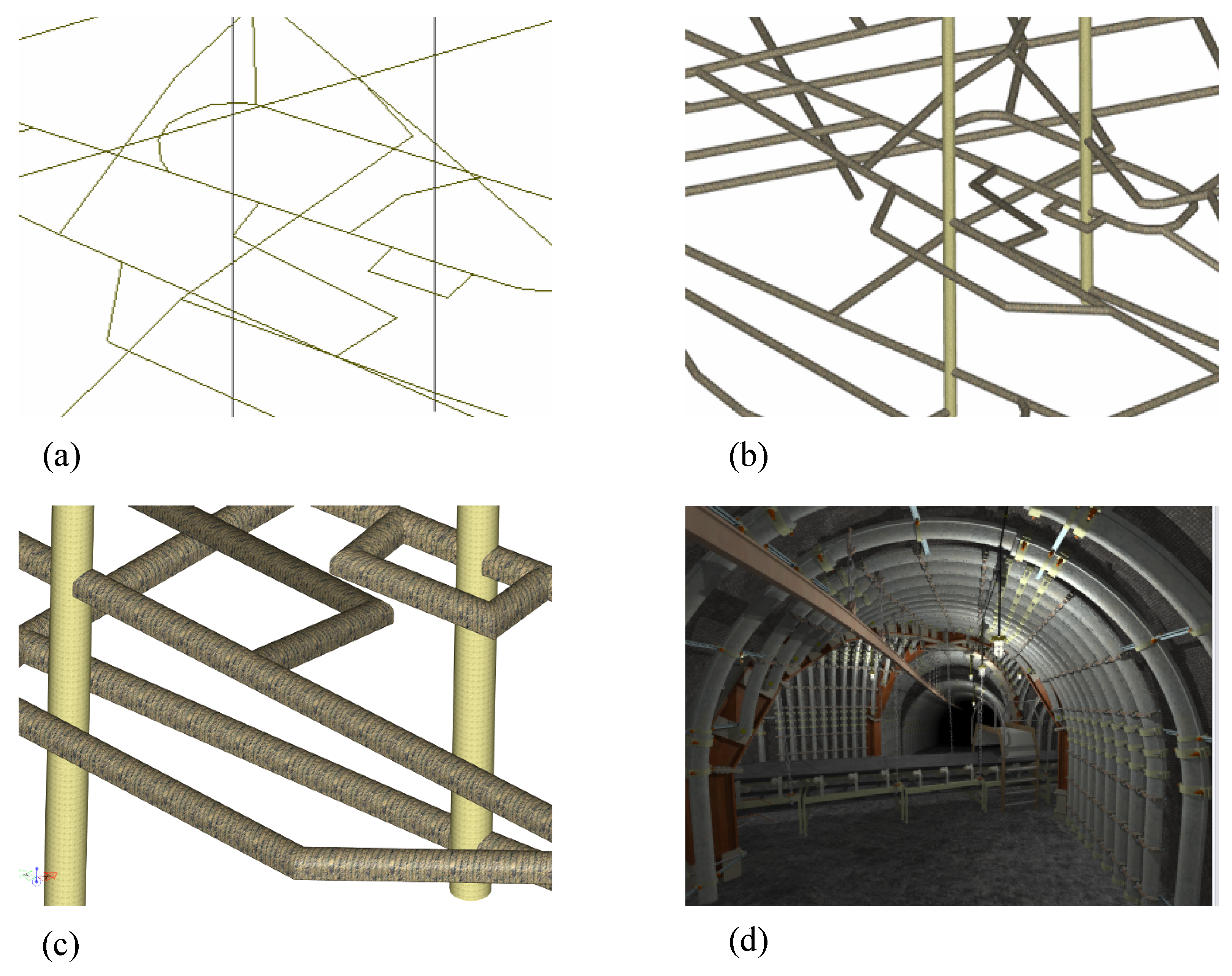
4.3. Three-Dimensional Modelling of Mining Data

A typical two-dimensional data presentation in the form of a mine workings map is mostly a well-standardised cartographic product used by all technical departments of a mine. In the field of three-dimensional mine workings cartography, there is no such standardisation anymore. GMP software providers equip the user with their own 3D working technologies binding the user to their products. Meanwhile, more and more state-of-the-art tools to support their work, such as VENTSIM, are appearing in more mine departments. This system requires a 3D model of the mine workings for its operation in order to model the ventilation system of the mine. The system supports both the mapping of workings from a flat map and the import of 3D data, e.g., from the mine design department, which uses GMP software and also maps 3D workings from a flat 2D map. It is, therefore, very important for there to be only one 3D excavation model in the mine, which would be a reference for all the technical departments in the mine.
Another research issue is the development of a method for the three-dimensional presentation of mining data. A systematisation of excavation models needs to be introduced, which will determine the different degrees of complexity of the excavation presentation. This issue is one of several issues related to the visualisation of spatial data in mining. A good example is the visualisation of underground mine workings, which can be presented as four different models. This can be thought of in terms of the concept of LoD (level of detail) for an underground mine. The notion of LoD exists both in computer graphics and in the field of building object modelling in spatial information systems [76]. In mining, a similar solution dedicated to underground mining, underground mine level of detail (UMLoD), can be proposed. Figure 2 shows all models representing the same data set in 4 different degrees of generalisation. The axial (linear) model of mine workings is the simplest. The circular (pipe) model replaces the lines with simple, easy-to-process pipe-type geometric data built around the axes of the workings. In order to be able to build a pipe model, the geometry of the axial model must meet the relevant conditions. The third model is a profile model created from cross-sections of the workings. The last model is a photorealistic model derived from a point cloud with reconstructed solid geometric objects. The development of these models was the subject of the master’s thesis of [77] and was realised outside the environment of GMP and GIS systems.
An extremely important issue besides the visualisation of such a model is the ability to work with these types of data. That is, the ability to open a data file in a short time and to manipulate the model. In the work of [78], these four models were tested in terms of the system’s processing performance during user operation. It turned out that only the first two models could be handled smoothly by the computer system and the other two no longer. Obviously, GMPs offer the models that these systems are able to handle. This example is the background to the broader issue of geoprocessing spatial data in a real-time environment [79].
The example presented here is one of the many issues of 3D and 4D digital cartography that require further research. Further issues in this area are as follows:
  • Visualisation of the deposit model with the completed, planned and projected exploitation;
  • Location, identification and visualisation of mine workings infrastructure equipment linked to systems supporting material and equipment management of the mine plant;
  • Locating, identifying and visualising the process of mining, haulage, extraction, enrichment, storage and sale of exploited raw material links to systems that monitor the output of each stage of its life cycle;
  • Visualisation of the fourth dimension—time;
  • The construction of the digital twin of the underground part of the mining plant.

4.4. Management of Data Processing Systems

Mining plants are characterised by the presence of so-called “information islands” [80], which are created by the individual technical departments of the mines in order to carry out their own activities within the ore exploitation process. They acquire data for their own information systems process and generate models, projects and reports for the head office (management). Under the conditions of a multi-year planned economy, such a model works. The market economy, on the other hand, forces production volumes to become more flexible in order to adapt to changing levels of demand. It also enforces the shaping of the quality parameters of the raw material—the final product of the mining plant [81]. Consequently, the existence of so-called “information islands” is a significant obstacle in terms of optimising data acquisition and the reuse of data and makes it difficult to carry out analyses in terms of mining production optimisation.
Many researchers recognise this problem and undertake research on the organisation and architecture of data processing in technical departments of mines. Initially, data management concepts envisaged the use of a GIS platform as the basis for unifying spatial data management at a mining site [82]. In later years, the construction of such systems in practice demonstrated the need to use many different IT components. The publication in [43] presents the concept of the MGIS system MINEFRAME, which uses four applications running on three databases. The data are modelled using object-oriented technology. On the other hand, the authors of the publication “Digital Mine” [80] propose the construction of a mining technology collaboration platform (MTCP) according to the indications of mining information modelling (MIM) as part of the Chinese “Digital Mine” concept. On the other hand, the author of this publication [83] proposes the use of off-the-shelf MINESCAPE and Deswik software in the system, which has been integrated into a single system with the IT systems used to date in JSW SA’s mining plants. Thus, a production line management system solution in the JSW S.A. has been created.
The integrated processing of spatial data from multiple sources and the verification of plans and projects against the actual results achieved requires a coherent process architecture for planning, designing and monitoring the entire raw material acquisition, processing and sales cycle. It also requires appropriate work organisation, qualified staff and modern hardware and software architecture. This issue is such a broad topic that it can be broken down into many smaller issues, three examples of which are listed below.

4.4.1. Methods of Integrating Spatial Data

An increasing number of different types of task-specific software are being introduced and used in many mining operations. There is a growing trend to supplement monolithic systems with cheaper software commonly used with specialised overlays. This generates problems related to the exchange of spatial data between applications and systems inside the mine, as well as with spatial information systems used by state and local government administrations and the economic environment. This problem is currently being solved in various ways:
  • The expansion of existing databases with a spatial data processing component or installation of such databases dedicated to spatial data management at the scale of the mining company.
  • The use of extraction, transformation and load (ETL) servers to transform features (i.e., geometric objects) between different specialised mining data processing systems. One of the more popular ETL servers on the market is Safe Software’s Feature Manipulation Engine (FME).
  • The use of spatial data service technologies, such as Web Feature Service (WFS) or Web Map Service (WMS), as defined by the Open Geospatial Consortium (OGC), or using commercial solutions, such as WebGIS.

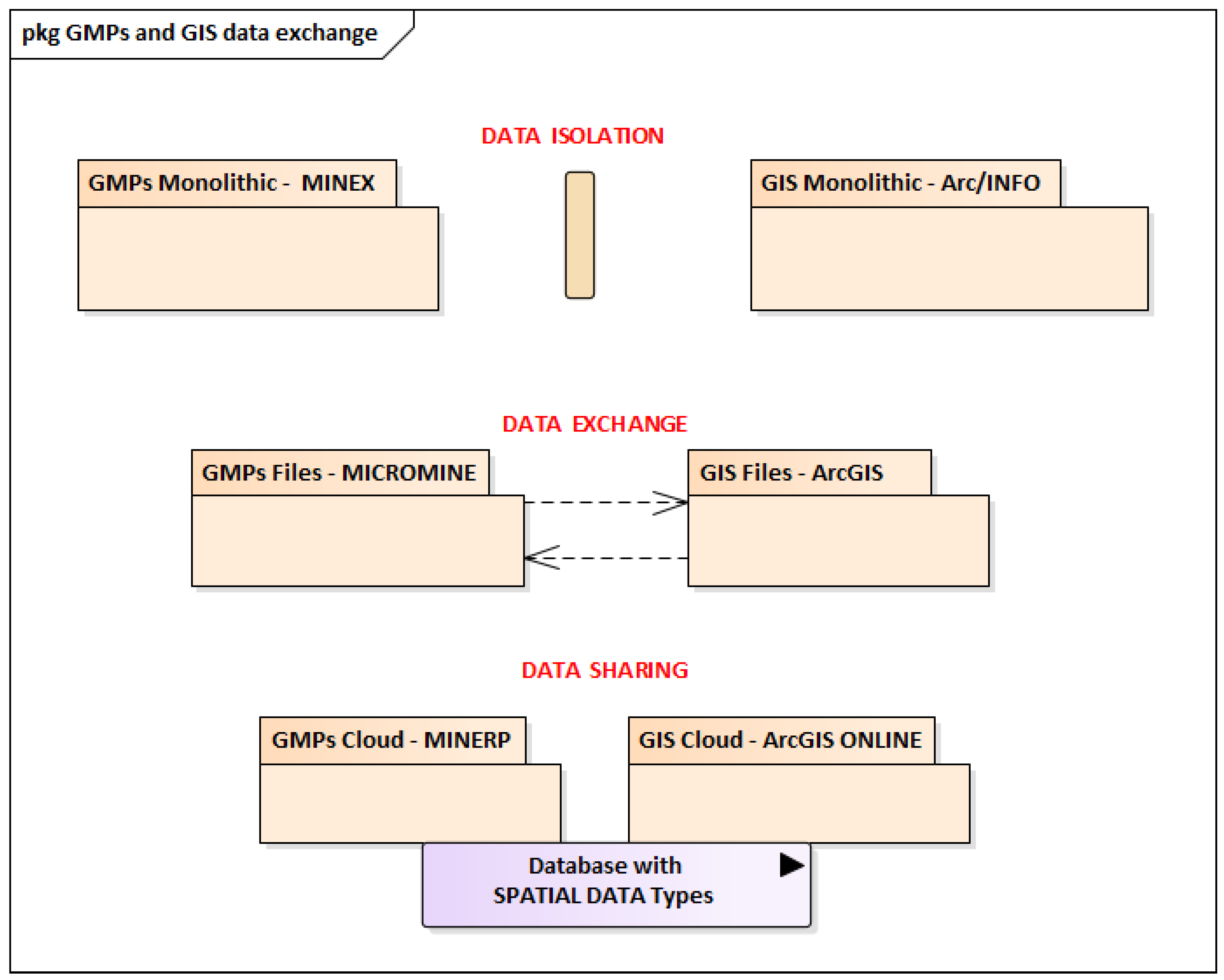
4.4.2. Separation of Spatial Data from Their Processing Systems

It is advantageous for a mining company to introduce methods to manage its spatial data resource in such a way that it is wholly or partly independent of software providers. An important issue is the problem of the distance to the data after the implementation of new software. It is important that the new data become the data resource of the mine and is accessible to other software providers as well as to as many employees as possible. Such an approach frees the spatial data resource from “VendorLock”, understood as locking the data within the delivered system and forces a reduction in the implementation of closed IT systems in favour of open-source technologies. The decisive data separation process is the software ordering/purchasing procedure. This is when it is decided how the newly ordered software will be implemented in the existing IT system and to what extent it will change the work organisation in the company.

4.4.3. Standardisation of Spatial Data in Mining

In the past, there have been many initiatives in the standardisation of mining spatial data to develop international standards for the exchange of geological and mining data. A very attractive implementation environment for spatial data standards was the OGC standards. They used the meta-language eXtensible Markup Language (XML) to build the Geography Markup Language (GML) standard, based on which other languages for the exchange of mining and geological data were developed. One of the first standards of this type for mining was the eXploration Mining Markup Language (XMML) [84], which allowed geological borehole geometries to be described along with sampling results. A year later, the British Geological Survey, building on the two languages GML and XMML, developed its own language GeoScience Markup Language (GeoSciML)—designed for geological surveys around the world [85]. Work has also been undertaken on using the GML language to build a spatial data model for geological information in coal mines [86]. However, there is no information on whether this model has become a standard. In the mining software company community, these standards have not entered into widespread use.
A renewed attempt to introduce mining data exchange standards was made by the non-profit organisation Global Mining Guidelines Group (GMG). It developed the Open Mining Format (OMF) standard in 2017, for which it has developed a library with an API software interface to support the standard. However, there is no information about its applications in mining practice. One of the more interesting OGC standards is the Well-Known Binary (WKB) relational database vector data storage structure. This new standard is already widely used in the new spatial data exchange file format *.gpkg (GeoPackage). Services defined by the OGC such as WMS or WFS have quite strong prospects for application in mining. Examples of their applications in mining will appear in the scientific literature, but there are not many of them. Therefore, the standardisation of the recording of mining–geological spatial data in information systems is still an open problem.
Another aspect of standardisation is controlled vocabularies, which ensure semantic interoperability of data. These are used in many industries and sciences [87]. In the case of mining, one case can be highlighted for the development of a controlled vocabulary for semantic interoperability of mineral exploration geodata for mining projects [88]. The construction of such vocabularies for mining is an essential part of effective data exchange, which is an important factor in its development.
This subchapter concludes with an attempt to standardise mining objects using object-oriented information systems modelling technology. The authors of the publication in [89] proposed the Standard Objects for the Mining Industry (SOMI) standard to implement the interoperability of any type of software used in mining. This ranges from software that controls mining machinery up to data warehouse programming. The authors did not provide details of this solution, presenting only the concept of it.

4.5. Big Data in Mining

In the field of geomatics, there is the problem of performing spatial analyses of large amounts of data [90,91]. In mineral mining, the problem of large amounts of data requiring processing is also apparent. One of the earliest publications demonstrating the use of Big Data technology in mining concerned the use of this technology to analyse geological data in order to improve and refine mineral deposit models for mining companies [92]. The amount of data of raster maps of the surface of mining areas as well as the amount of data from laser scanning of mine workings is so large that the processing time with traditional methods is too long and it becomes necessary to use Big Data [93]. Big Data has also found its way into regional metal pollution risk assessment on a mining area basis. It should be emphasised that the use of Big Data in a mining site is, of course, not only about spatial data. According to Qi [94], it is possible to distinguish four areas from where the data come from: measurements, crew identifiers, process data and mining machine data. In these areas, the spatial factor does not always play an important role, but in the context of the virtualisation of the mine plant, every piece of information in the technical part of the mine has some spatial reference.

4.6. Augmented Reality and Virtual Reality

Augmented reality (abbreviated AR) is a visualisation system that combines an image of a fragment of the real world viewed by the user at a given time with a superimposed digital representation of that world, computer generated from a pre-prepared digital spatial model of the image of that real world. With this technology, a miner can view a pit at the face with a combined digitally generated section of the deposit model, a map of the roof support and other features of the rock mass modelled digitally. Proposals for mining applications of this type of solution emerged very quickly [95] but have not been implemented for widespread use.
Virtual reality (VR) depicts the real world on a computer. It is a technology aimed at mapping the real world and visualising it for the user in a way that is as close as possible to the actual perception of the outside world—the visualised part of reality. With this technology, a miner can view a mining pit in the safety of an office. VR technologies have found widespread use in mining health and safety training. This is because the technology enables a section of the mine workings to be recreated, where the consequences of non-compliance with health and safety regulations can be demonstrated including a realistic visualisation of the damage caused during an accident [96]. Of importance is the degree and quality of the representation of virtual reality in the eyes of the user and the level of its sensation, including touch [97], and the possibility of integrating into this reality data from measurement sensors located in the excavation site [98]. One of the limitations of implementing VR and AR in mining is the lack of a 3D model of the workings. In the case of AR, there is also the problem of the time interval for updating the excavation model. For this reason, the use of AR is currently limited to open-pit mining operations [99], and VR is used in various training systems for mining employees.

4.7. Data Exchange and Collaboration with the Social, Administrative and Economic Environment and in the Mine Life Cycle

The primary form of data exchange is the import and export of spatial data files. Geoinformatics technologies allow for data sharing, which can facilitate and automate access to data. In this regard, data exchange refers to the capacity of the mining company’s internal systems, which should be prepared to exchange data with the company’s customers, external systems of state and government entities and with external cooperators. Of the mining systems, the systems that manage the economics of the mining production process and its monitoring and control [100] are particularly important. Consideration should also be given to the social environment of the mining site, for which the mining site should shape its information policy on the provision of spatial information about the environmental impacts of mining operations. This can be conducted through WebGIS or SDI technology. Spatial data of a mining facility are also data on the environmental impacts of mining activities. This is a very important contribution in the context of achieving the sustainable development of a mining site. Achieving sustainability goals in the life cycle of a mine [101] requires a series of measures that are planned and monitored precisely by means of geoinformatics systems.

4.8. Mining Geomatics Engineer as a New Profession

Mining geomatics can be the basis for defining a new type of profession within the mining industry that combines basic mining and geological knowledge with geo-informatics skills to maximise the use of hardware and software to effectively manage mining operations processes. The mining geomatics engineer must be knowledgeable in the acquisition, implementation and maintenance of modern IT solutions, which will enable him/her to act as a manager of the spatial data infrastructure of the technical departments of the mining plant. In the future, he/she will be responsible for the construction and organisation of geospatial databases in which he/she will coordinate the collection of data from the various technical departments of the various modelling and forecasting systems used in the technical departments of the mine. They will also be responsible for the introduction and application of procedures related to the mining of spatial data collected in these systems.

5. Discussion

The definition analyses performed showed that there were several terms that were formulated to describe the use of spatial data processing systems in mining. The analysis of the term MGIS showed its unsuitability for use in describing a domain or class of software that processes spatial data in mining. Based on this analysis, three terminological postulates were formulated, which formed the basis from the definition of a new name. Subsequent analyses related to the term geomatics justified the creation of a single, universal term “mining geomatics” to denote the use of technology for processing mining spatial data referenced to the Earth’s surface using any IT system. The new term should not be regarded as a new scientific discipline. Like many other newly created definitions, it does not describe a new science and or research discipline but is a “community of practice” [102]. The new term should clearly be associated with mining, where geoinformatics technologies have been applied to spatial data processing.
Based on an analysis of the data exchange between GIS software and GMPs, three phases of the development of GIS software and GMPs were identified. This allows a clear distinction to be made between the technological capabilities of a particular type of software system due to its data exchange capabilities. The third phase of software development was identified by the use of technology to store spatial data in the form of vector and raster geometry directly in relational database tables. This feature of spatial data storage makes it possible to formulate the thesis of a convergence of the directions of GMPs and GIS software development, which in the future may lead to the construction of a common geometric data resource of the mine.
Today, an increasing number of new industrial developments are infiltrating the mining industry. One of these is the concept of “Industry 4.0”, which involves the replacement of human labour by machines and autonomous devices. This implies the need for mobile, real-time cyber–physical systems (CPSs) to recognise the physical environment, enabling the machine to move around and perform a variety of physical tasks [103]. A CPS is one that recognises its surroundings with the help of sensors (laser, radar or optical) and plans its own movement to a designated destination. Such systems can only perform their tasks on the basis of a pre-supplied plan of the work to be carried out, including the location and route they should take to perform their work. In this case, it is also necessary to have a spatial model of the mine workings in order to plan the work. An important feature of CPSs is the ability to provide real-time spatial data of the state of the workings in those areas of the mine through which they have moved or in which they have carried out their work. In this case, CPSs can provide data for the construction of a digital image of the mine workings complementing the “digital twins” concept for the mine plant in terms of updating mine workings data [104]. The concept of combining the autonomy of Industry 4.0 machines in a “digital twins” environment was already identified in 2015 [105] and further developed in concepts by subsequent researchers [106]. Managing a digital model of mine workings with autonomous machines and equipment will be a challenge for future mining geomatics. It is worth mentioning that as early as 2008, the great importance of CPSs for the development of geomatics was predicted and highlighted [107].

6. Conclusions

This article identified and discussed a number of technological and nomenclatural considerations found in the area of spatial data processing in mining. The main conclusion of these analyses is that the term mining geomatics can be applied in practice. The outline of common practices presented in the form of the Body Of Knowledge for mining geomatics presents an initial range of research areas and concepts that form a coherent body of “community of practice” regardless of the type and name of the software used to process spatial data in mining.
The first use of the term mining geomatics should be made by using it as a keyword in scientific articles. There are many scientific articles whose content can be categorised as mining geomatics. This will make it possible to search for those articles whose content presents the results of analyses of mining spatial data acquired by various measurement methods, processed by means of information systems and presented on the web. It would certainly be very helpful if articles on topics such as the development of a mining dataset [108], the use of a geoportal to present mining data [109], methods for assessing the impact of mining using GIS and remote sensing technologies [110] and the use of remote sensing in post-mining areas [111] could be included in one listing when searching using the keyword “mining geomatics”. The use of this term in a keyword system is bound to isolate a fairly coherent category of articles on the same topic.
Finally, it is worth referring to the abbreviation MGIS and mentioning that for many years there has been the abbreviation WebGIS, which is an extremely well-established term for the use of GIS technology on the Internet, widely used in science and the economy [112]. Hence, by analogy, the abbreviation MobGIS can be proposed for the implementation of GIS on mobile devices. Such an acronym is more readable and unambiguous.

Funding

This article was prepared under a research subsidy of the AGH University of Krakow (no.: 16.16.150.545).

Data Availability Statement

During the work on this article, no datasets were produced that could be published.

Acknowledgments

This article was prepared under the research conducted on AGH University of Krakow.

Conflicts of Interest

The author declares no conflict of interest. The funders had no role in the design of the study; in the collection, analyses or interpretation of data; in the writing of the manuscript; or in the decision to publish the results.

References

  1. Apollo, M.; Jakubiak, M.; Nistor, S.; Lewinska, P.; Krawczyk, A.; Borowski, L.; Specht, M.; Krzykowska-Piotrowska, K.; Marchel, L.; Pęska-Siwik, A.; et al. Geodata in science—A review of selected scientific fields. Acta Sci. Pol. Form. Circumiectus 2023, 22, 1–30. [Google Scholar]
  2. Kajzar, V.; KukuStsch, R.; Heroldova, N. Verifying the possibilities of using a 3D laser scanner in the mining underground. Acta Geodyn. Geomater. 2015, 12, 51–58. [Google Scholar] [CrossRef] [Green Version]
  3. Lipecki, T.; Jaśkowski, W. Application of laser scanners to determine the shape of mine excavations for safety assessment, using the example of the cross-cut mina in the Salt Mine Wieliczka. Rep. Geod. 2009, 2/87, 239–250. [Google Scholar]
  4. Chen, S.; Walske, M.L.; Davies, I.J. Rapid mapping and analysing rock mass discontinuities with 3D terrestrial laser scanning in the underground excavation. Int. J. Rock Mech. Min. Sci. 2018, 110, 28–35. [Google Scholar] [CrossRef]
  5. Nghia, N.V.; Long, N.Q.; Cuc, N.T.; Bui, X.N. Applied Terrestrial Laser Scanning for coal mine high definition mapping. World Min.-Surf. Undergr. 2019, 71, 237–242. [Google Scholar]
  6. Lipecki, T.; Jaskowski, W.; Gruszczynski, W.; Matwij, K.; Matwij, W.; Ulmaniec, P. Inventory of the geometric condition of inanimate nature reserve Crystal Caves in “Wieliczka” Salt Mine. Acta Geod. Geophys. 2016, 51, 257–272. [Google Scholar] [CrossRef] [Green Version]
  7. Singh, S.K.; Banerjee, B.P.; Raval, S. Three-Dimensional Unique-Identifier-Based Automated Georeferencing and Coregistration of Point Clouds in Underground Mines. Remote Sens. 2021, 13, 3145. [Google Scholar] [CrossRef]
  8. Jabłoński, M.; Jaśkowski, W. The usage of telemetry measurements methods in order to determine shaft tube. Bud. Archit. 2016, 15, 63–74. [Google Scholar] [CrossRef]
  9. Jones, E. Mobile LiDAR for underground geomechanics: Learnings from the teens and directions for the twenties. In Proceedings of the Second International Conference on Underground Mining Technology; Wesseloo, J., Ed.; Australian Centre for Geomechanics: Crawley, Australia, 2020; pp. 3–26. [Google Scholar] [CrossRef]
  10. Palamara, D.R.; Nicholson, M.; Flentje, P.; Baafi, P.; Brassington, G.M. An evaluation of airborne laser scan data for coalmine subsidence mapping. Int. J. Remote Sens. 2007, 28, 3181–3203. [Google Scholar] [CrossRef]
  11. Lewińska, P.; Dyczko, A. Thermal digital terrain model of a coal spoil tip—A way of improving monitoring and early diagnostics of potential spontaneous combustion areas. J. Ecol. Eng. 2016, 17, 170–179. [Google Scholar] [CrossRef]
  12. Gocał, J.; Bałut, A.; Kocierz, R.; Kuras, P.; Ortyl, L.; Owerko, T.; Rączka, A.; Strach, M.; Szpyra, R. Precyzyjne pomiary drgań budowli przy użyciu naziemnego radaru interferometrycznego. Arch. Fotogram. Kartogr. Teledetekcji 2009, 19, 123–142. [Google Scholar]
  13. Szafarczyk, A. Możliwości zastosowania naziemnej interferometrii radarowej w górnictwie. In Geomatyka górnicza—Praktyczne zastosowania; Krawczyk, A., Dyczko, A., Eds.; Fundacja dla Akademii Górniczo-Hutniczej im. Stanisława Staszica: Kraków, Poland, 2013; pp. 67–80. [Google Scholar]
  14. Gabriel, A.K.; Goldstein, R.M.; Zebker, H.A. Mapping small elevation changes over large areas: Differential radar interferometry. J. Geophys. Res. 1989, 94, 9183. [Google Scholar] [CrossRef]
  15. Perski, Z. Applicability of ERS-1 and ERS-2 insar for land subsidence monitoring in the Silesian coal mining region, Poland. In Proceedings of the International Archives of Photogrametry and Remote Sensing Vol. XXXII Part 7. ISPRS Commission VII, Working Group 6, Budapest, Hungary, 1–4 September 1998; pp. 555–558. [Google Scholar]
  16. Jiang, X.; Min, X.; Ye, T.; Li, X.; Hu, X. Monitoring the subsidence at different periods in high underground water level coal mine areas using differential interferometric synthetic aperture radar (D-InSAR). Geocarto Int. 2023, 38, 1–11. [Google Scholar] [CrossRef]
  17. Ferretti, A.; Prati, C.; Rocca, F. Permanent scatterers in SAR interferometry. IEEE Trans. Geosci. Remote Sens. 2001, 39, 8–20. [Google Scholar] [CrossRef]
  18. Xia, Y.; Kaufmann, H.; Guo, X. Differential SAR interferometry using corner reflectors. In Proceedings of the IEEE International Geoscience and Remote Sensing Symposium, Toronto, ON, Canada, 24–28 June 2002; Volume 2, pp. 1243–1246. [Google Scholar] [CrossRef]
  19. Ren, H.; Zhao, Y.; Xiao, W.; Hu, Z. A review of UAV monitoring in mining areas: Current status and future perspectives. Int. J. Coal Sci. Technol. 2019, 6, 320–333. [Google Scholar] [CrossRef] [Green Version]
  20. Puniach, E.; Gruszczyński, W.; Stoch, T.; Mrocheń, D.; Ćwiąkała, P.; Sopata, P.; Pastucha, E.; Matwij, W. Determination of the coefficient of proportionality between horizontal displacement and tilt change using UAV photogrammetry. Eng. Geol. 2023, 312, 106939. [Google Scholar] [CrossRef]
  21. Westoby, M.; Brasington, J.; Glasser, N.; Hambrey, M.; Reynolds, J. ‘Structure-from-Motion’ photogrammetry: A low-cost, effective tool for geoscience applications. Geomorphology 2012, 179, 300–314. [Google Scholar] [CrossRef] [Green Version]
  22. Magiera, W.; Vārna, I.; Mitrofanovs, I.; Silabrieds, G.; Krawczyk, A.; Skorupa, B.; Apollo, M.; Maciuk, K. Accuracy of Code GNSS Receivers under Various Conditions. Remote Sens. 2022, 14, 2615. [Google Scholar] [CrossRef]
  23. Gao, J.-X.; Hu, H. Advanced GNSS technology of mining deformation monitoring. Procedia Earth Planet. Sci. 2009, 1, 1081–1088. [Google Scholar] [CrossRef] [Green Version]
  24. Lian, X.; Li, Z.; Yuan, H.; Hu, H.; Cai, Y.; Liu, X. Determination of the Stability of High-Steep Slopes by Global Navigation Satellite System (GNSS) Real-Time Monitoring in Long Wall Mining. Appl. Sci. 2020, 10, 1952. [Google Scholar] [CrossRef] [Green Version]
  25. Vrublova, D.; Kapica, R.; Gibesova, B.; Mudruňka, J.; Struś, A. Application of GNSS technology in surface mining. Geod. Cartogr. 2016, 42, 122–128. [Google Scholar] [CrossRef] [Green Version]
  26. Liu, H.; Pan, W.; Hu, Y.; Li, C.; Yuan, X.; Long, T. A Detection and Tracking Method Based on Heterogeneous Multi-Sensor Fusion for Unmanned Mining Trucks. Sensors 2022, 22, 5989. [Google Scholar] [CrossRef]
  27. Longley, P.; Goodchild, M.; Maguire, D.; Rhind, D. Geographic Information Systems and Science, 2nd ed.; John Wiley & Sons: Hoboken, NJ, USA, 2005. [Google Scholar]
  28. Filipova, S.; Filipov, D.; Raeva, P. Creating 3D model of an open pit quarry by UAV imaging and analysis in GIS. In Proceedings of the International Conference on Cartography and GIS, Albena, Bulgaria, 13–17 June 2016; Volume 6, p. 652. [Google Scholar]
  29. Kapageridis, I. The Future of Mine Planning Software—New Tools and Innovations. In Proceedings of the International Mining Congress and Exhibition of Turkey, Antalya, Turkey, 14–17 April 2005. [Google Scholar]
  30. Fotheringham, M.; Paudyal, D.R. Combining terrestrial scanned datasets with UAV point clouds for mining operations. ISPRS Ann. Photogramm. Remote Sens. Spat. Inf. Sci. 2021, V-4-2021, 129–138. [Google Scholar] [CrossRef]
  31. Choi, Y.; Baek, J.; Park, S. Review of GIS-based applications for mining: Planning, operation, and environmental management. Appl. Sci. 2020, 10, 2266. [Google Scholar] [CrossRef] [Green Version]
  32. Katakwa, T.; Musingwini, C.; Genc, B. Online database of mine planning and peripheral software used in the South African mining industry. J. S. Afr. Inst. Min. Metall. 2013, 113, 497–504. [Google Scholar]
  33. Krawczyk, A. Geomatics and Mining Geoinformation—Their Practical Applications and Development Barriers, 1st ed.; Dissertations Monographs; AGH University of Science and Technology Press: Kraków, Poland, 2019. (In Polish) [Google Scholar]
  34. Krawczyk, A. Proposal of Redefinition of the Terms Geomatics and Geoinformatics on the Basis of Terminological Postulates. ISPRS Int. J. Geo-Inf. 2022, 11, 557. [Google Scholar] [CrossRef]
  35. Krawczyk, A. Attempt at the systematics of storing attributes and topology of geometric objects in geographic information systems. Stud. Inform. 2011, 2B/32, 189–201. (In Polish) [Google Scholar]
  36. Coulthard, M.A.; Journet, N.C.; Swindells, C.F. Integration of stress analysis into mine excavation design. In Proceedings of the U.S. Symposium on Rock Mechanics, Norman, OK, USA, 10–12 July 1991; p. 451. [Google Scholar]
  37. Bonham-Carter, G.F. Geographic Information Systems for Geoscientists: Modelling with GIS; Number 13; Elsevier: Amsterdam, The Netherlands, 1994. [Google Scholar]
  38. Micromine. MICROMINE Launches Micromine 2011. WWW Page. 2011. Available online: http://www.micromine.com/sites/default/files/MICROMINE-20Launches-20Micromine-202011.pdf (accessed on 20 June 2014).
  39. Wang, J.; Guo, D. The building and development of China’s Mine Geographic Information System. China Coal 1996, 6, 24–27. [Google Scholar]
  40. Li, R.; Saxena, N.K. Development of an integrated marine geographic information system. Mar. Geod. 1993, 16, 293–307. [Google Scholar] [CrossRef]
  41. Qi, A.; Wu, L.; Yang, K.; Hu, D.; Yin, Z.; Deng, Z. Development and application of mine geographical information system. In Computer Applications in the Mineral Industries; CRC Press: Boca Raton, FL, USA, 2001; pp. 825–828. [Google Scholar]
  42. Péter, S.; Péter, M. Specialized mining GIS system MineGIS SMZ Jelšava. Acta Montan. Slovaca 2005, 10, 377–379. [Google Scholar]
  43. Lukichev, S.V.; Nagovitsyn, O.V. Modeling Objects and Processes within a Mining Technology as a Framework for a System Approach to Solve Mining Problems. J. Min. Sci. 2018, 54, 1041–1049. [Google Scholar] [CrossRef]
  44. Vinogradov, A.; Ivanov, A.; Gerasimov, A.; Ovsyannikov, A. The Geological and Mining-Surveyor Support of the Drilling and Blasting Operations at the Open-Cut Mines with the Use of the Mining–Geological Informational GIS GEOMIX System. Ferr. Metall. Bull. Sci. Tech. Econ. Inf. 2015, 10, 32–35. [Google Scholar]
  45. Cardoso, J.; Rocha, A.; Lopes, J.C. M-GIS—Mobile and Interoperable Access to Geographic Information. In Electronic Government. EGOV 2004; Lecture Notes in Computer Science; Springer: Berlin/Heidelberg, Germany, 2004; pp. 400–405. [Google Scholar] [CrossRef] [Green Version]
  46. Tang, W.S.M.; Selwood, J. Mobile Geographic Information Services (M-GIS): Technology That Changes the Way We Navigate Our World. In Proceedings of the IAPRS, COMMISSION II, IAPRS, Xi’an, China, 20–23 August 2002; Volume 34. [Google Scholar]
  47. Gunn, S. Mobile Geographic Information Systems (MGIS). In The Encyclopedia of Archaeological Sciences; Wiley Blackwell: Hoboken, NJ, USA, 2018; pp. 1–4. [Google Scholar] [CrossRef]
  48. El Fhel, B.; Sardi, L.; Idri, A. A Requirements Catalog of Mobile Geographic Information System for Data Collection. In Trends and Applications in Information Systems and Technologies. WorldCIST 2021; Springer: Cham, Switzerland, 2021; pp. 324–336. [Google Scholar] [CrossRef]
  49. Dubuisson, B. La Photogrammétrie des Plans Topographiques et Parcellaires; Eyrolles: Paris, France, 1969. [Google Scholar]
  50. Bédard, Y. Geomatics. In Encyclopedia of Geographic Information Science; Kemp, K., Ed.; Sage Publications: Thousand Oaks, CA, USA, 2008; pp. 195–197. [Google Scholar]
  51. Molenaar, M. Status and problems of geographical information systems. The necessity of a geoinformation theory. ISPRS J. Photogramm. Remote Sens. 1991, 46, 85–103. [Google Scholar] [CrossRef]
  52. Longley, P.A.; Brooks, S.; Macmillan, W.; McDonnell, R. Geocomputation: A Primer; Wiley: Hoboken, NJ, USA, 1998. [Google Scholar]
  53. Carranza, E.J.M. Geocomputation of mineral exploration targets. Comput. Geosci. 2011, 37, 1907–1916. [Google Scholar] [CrossRef]
  54. Allison, M.L.; Snyder, W.S.; Walker, J.D. Geoinformatics: A nascent revolution in the Earth Sciences. GSA Today 2002, 12, 17. [Google Scholar] [CrossRef]
  55. Gewin, V. Mapping opportunities. Nature 2004, 427, 376–377. [Google Scholar] [CrossRef]
  56. Goodchild, M.F. GIScience, Geography, Form, and Process. Ann. Assoc. Am. Geogr. 2004, 94, 709–714. [Google Scholar] [CrossRef]
  57. Šíma, J. Geomatics and geoinformatics in modern information society–projection of new trends into their curricula at the University of West Bohemia in Pilsen. In Proceedings of the Scientia Est Potentia–Knowledge Is Power, FIG Commission 2 Symposium, Prague, Czech Republic, 7–9 June 2007; pp. 7–9. [Google Scholar]
  58. MK, C.; Pal, D.; Ahmad, M.; Singh, R. Application of Geomatic Information Technology in Mineral Industry. MINETECH 2001, 22, 17–25. [Google Scholar]
  59. Pavlis, N.K. Geomatic methods for the analysis of data in the Earth sciences. Eos Trans. Am. Geophys. Union 2001, 82, 339. [Google Scholar] [CrossRef]
  60. Gond, V.; Bluteau, J.; Kotchi, S.O.; Koné, B.B.; Linares, S. Geomatics, a monitoring tool for illegal gold-mining in French Guiana; [La géomatique, outil de surveillance de l’orpaillage clandestin en guyane française]. Can. J. Lat. Am. Caribb. Stud. 2009, 34, 177–193. (In French) [Google Scholar] [CrossRef]
  61. Khichar, R.; Upadhyay, S.S. Wireless sensor networks and their applications in geomatics: Case study on developments in developing countries. Appl. Geomat. 2010, 2, 43–48. [Google Scholar] [CrossRef] [Green Version]
  62. Cadoppi, P.; Camanni, G.; Damiano, A.; Fusetti, E.; Monticelli, F.; Perotti, L.; Perrone, G. 3D model reconstruction of mineralizations in Alpine context. Examples of geomatics approach on the talc mineralization mine in Germanasca Valley and the Balangero asbestos mine (Western Alps). Rend. Online Soc. Geol. Ital. 2010, 11, 63–64. [Google Scholar]
  63. Blachowski, J.; Górniak-Zimroz, J.; Milczarek, W.; Pactwa, K. Applications of Geomatics in Surface Mining. IOP Conf. Ser. Earth Environ. Sci. 2017, 95, 042009. [Google Scholar] [CrossRef] [Green Version]
  64. Blachowski, J.; Górniak-Zimroz, J.; Milczarek, W.; Pactwa, K. Applications of geomatics in underground mining. Int. Multidiscip. Sci. GeoConf. SGEM 2017, 17, 799–810. [Google Scholar]
  65. Nguyen, L.Q.; Vo, D.N.; Vo, M.C. Advanced Mining Geomatic Technologies Serving Open-Pit Mining Operation in Vietnam. J. Min. Earth Sci. 2020, 61, 125–133. [Google Scholar] [CrossRef]
  66. Popescu, E.; Popescu, C.A.; Herbei, M.V.; Horablaga, A.; Smulea, A. 3D modeling of waste dumps in order to ecology of mining areas. Agrolife Sci. J. 2020, 9, 240–249. [Google Scholar]
  67. Perfetti, L.; Teruggi, S.; Achille, C.; Fassi, F. Rapid and low-cost photogrammetric survey of hazardous sites, from measurements to VR dissemination. Int. Arch. Photogramm. Remote Sens. Spat. Inf. Sci. 2022, 48, 207–214. [Google Scholar] [CrossRef]
  68. Krawczyk, A. Mining geomatics as an application of geomatics methods in mining geodesy. Ann. Geomat. 2004, 2, 172–180. (In Polish) [Google Scholar]
  69. Michalak, J. Geomatyka (geoinformatyka)—Czy nowa dyscyplina? Przegląd Geol. 2000, 48, 673–678. [Google Scholar]
  70. Paradis, M. From geodesy to geomatics. Can. Surv. 1981, 35, 262–268. [Google Scholar] [CrossRef]
  71. Coutts, B. The name game: Again. Geomat. World 2017, 26, 14–15. [Google Scholar]
  72. Romme, G. The Quest for Professionalism: The Case of Management and Entrepreneurship; Oxford University Press: Oxford, UK, 2016. [Google Scholar]
  73. Xiao, W.G. On the Establishment of Independent Coordinate System for Mining Area Integration. Nonferr. Met. Sci. Eng. 2009, 23, 15–17. (In Chinese) [Google Scholar]
  74. Sokoła-Szewioła, V.; Poniewiera, M.; Pomykoł, M. Algorithm of transformation between the local system Borowa Góra and the state system PL-2000 on the example of PG Silesia. IOP Conf. Ser. Earth Environ. Sci. 2018, 198, 012014. [Google Scholar] [CrossRef]
  75. Warchala, M.; Leszczyński, R.; Jędrzejec, M. Ujednolicenie układów współrzędnych stosowanych w KGHM „Polska Miedź” S.A. In Proceedings of the Szkoła Eksploatacji Podziemnej 2011; Kicki, J., Ed.; IGSMiE: Kraków, Poland, 2011. [Google Scholar]
  76. Biljecki, F.; Zhao, J.; Stoter, J.; Ledoux, H. Revisiting the concept level of detail in 3D city modelling. In Proceedings of the 8th 3DGeoInfo Conference & WG II/2 Workshop, Istanbul, Turkey, 27–29 November 2013; ISPRS Archives Volume II-2/W1;. ISPRS, Copernicus Publications: Göttingen, Germany, 2013. [Google Scholar]
  77. Galica, D. An Attempt to Use Computer Graphics for the Cartographic Presentation of Mine Workings. Master’s Thesis, AGH University of Science and Technology, Kraków, Poland, 2008. (In Polish). [Google Scholar]
  78. Krawczyk, A.; Kula, R. Analysis of variants of arc-suscesible case models of mining excavations in view of computer processing. Ann. Geomat. 2013, XI, 51–61. (In Polish) [Google Scholar]
  79. McCullough, A.; Barr, S.; James, P. A Typology of Real-Time Parallel Geoprocessing for the Sensor Web Era. In Proceedings of the Integrating Sensor Web and Web-Based Geoprocessing, CEUR Workshop Proceedings, Utrecht, The Netherlands, 18 April 2011; Volume 712. [Google Scholar]
  80. Wang, J.; Bi, L.; Wang, L.; Jia, M.; Mao, D. A mining technology collaboration platform theory and its product development and application to support China’s digital mine construction. Appl. Sci. 2019, 9, 5373. [Google Scholar] [CrossRef] [Green Version]
  81. Dyczko, A. Modeling of quality parameters of the coking coal as a process of adapting the output to the contracted parameters. Acta Montan. Slovaca 2022, 27, 11–26. [Google Scholar]
  82. Banerjee, T.K.; Roy, S.; Dey, S. A GIS solution for an integrated underground coal mine management: A conceptual framework. J. Manag. Policies Pract. 2014, 2, 129–143. [Google Scholar]
  83. Dyczko, A. Construction of a heuristic architecture of a production line management system in the JSW SA Mining Group in the context of output stabilization, quality improvement and the maximization of economic effects. Miner. Resour. Manag. 2021, 37, 219–238. [Google Scholar]
  84. Cox, S.J.D. XMML—A standards conformant XML language for transfer of exploration data. ASEG Ext. Abstr. 2004, 2004, 1–4. [Google Scholar] [CrossRef]
  85. Sen, M.; Duffy, T. GeoSciML: Development of a generic GeoScience Markup Language. Comput. Geosci. 2005, 31, 1095–1103. [Google Scholar] [CrossRef] [Green Version]
  86. Wang, Z.; Gao, W.; Qu, H.; Wu, Z. GML-based 3D spatial data model for geoscience information in coal mines. In Proceedings of the 2013 21st International Conference on Geoinformatics, Kaifeng, China, 20–22 June 2013. [Google Scholar] [CrossRef]
  87. Albertoni, R.; Martino, M.D.; Podestà, P.; Abecker, A.; Wössner, R.; Schnitter, K. LusTRE: A framework of linked environmental thesauri for metadata management. Earth Sci. Inform. 2018, 11, 525–544. [Google Scholar] [CrossRef]
  88. Ma, X.; Wu, C.; Carranza, E.J.M.; Schetselaar, E.M.; van der Meer, F.D.; Liu, G.; Wang, X.; Zhang, X. Development of a controlled vocabulary for semantic interoperability of mineral exploration geodata for mining projects. Comput. Geosci. 2010, 36, 1512–1522. [Google Scholar] [CrossRef]
  89. Inostroza, P.; Pezo, A.C.; Nieto, A. SOMI: Towards a Standard Representation of Mining Objects. IFAC Proc. Vol. 2009, 42, 303–307. [Google Scholar] [CrossRef]
  90. Li, D.; Shen, X.; Wang, L. Connected Geomatics in the big data era. Int. J. Digit. Earth 2018, 11, 139–153. [Google Scholar] [CrossRef]
  91. Jeansoulin, R. Review of Forty Years of Technological Changes in Geomatics toward the Big Data Paradigm. ISPRS Int. J. Geo-Inf. 2016, 5, 155. [Google Scholar] [CrossRef] [Green Version]
  92. Ming, J.; Zhang, L.; Sun, J.; Zhang, Y. Analysis models of technical and economic data of mining enterprises based on big data analysis. In Proceedings of the 2018 IEEE 3rd International Conference on Cloud Computing and Big Data Analysis (ICCCBDA), Chengdu, China, 20–22 April 2018; pp. 224–227. [Google Scholar]
  93. Kosydor, P.; Warchala, E.; Krawczyk, A.; Piórkowski, A. Determinants of large-scale spatial data processing in Polish mining. AIP Conf. Proc. 2020, 2209, 040007. [Google Scholar] [CrossRef]
  94. Qi, C.C. Big data management in the mining industry. Int. J. Miner. Metall. Mater. 2020, 27, 131–139. [Google Scholar] [CrossRef]
  95. Zhang, S.X. Augmented Reality on Longwall Face for Unmanned Mining. Appl. Mech. Mater. 2010, 40–41, 388–391. [Google Scholar] [CrossRef]
  96. van Wyk, E.; de Villiers, R. Virtual Reality Training Applications for the Mining Industry. In Proceedings of the AFRIGRAPH ’09: Proceedings of the 6th International Conference on Computer Graphics, Virtual Reality, Visualisation and Interaction in Africa, Pretoria, South Africa, 4–6 February 2009; Association for Computing Machinery: New York, NY, USA, 2009; pp. 53–63. [Google Scholar] [CrossRef]
  97. Bednarz, T.; James, C.; Widzyk-Capehart, E.; Caris, C.; Alem, L. Distributed Collaborative Immersive Virtual Reality Framework for the Mining Industry. In Machine Vision and Mechatronics in Practice; Springer: Berlin/Heidelberg, Germany, 2015; pp. 39–48. [Google Scholar] [CrossRef]
  98. Brzychczy, E.; Trzcionkowska, A. Process-Oriented Approach for Analysis of Sensor Data from Longwall Monitoring System. In Advances in Intelligent Systems and Computing; Springer International Publishing: Berlin/Heidelberg, Germany, 2018; pp. 611–621. [Google Scholar] [CrossRef]
  99. Mining.com. Maptek Brings Augmented Reality to the Mining Industry. WWW Page. 2013. Available online: http://www.mining.com/web/maptek-brings-augmented-reality-to-the-mining-industry (accessed on 22 March 2019).
  100. Blachowski, J.; Chrzanowski, A.; Szostak-Chrzanowski, A. Application of GIS Methods in Assessing Effects of Mining Activity on Surface Infrastructure. Arch. Min. Sci. 2014, 59, 307–321. [Google Scholar] [CrossRef]
  101. Asr, E.T.; Kakaie, R.; Ataei, M.; Mohammadi, M.R.T. A review of studies on sustainable development in mining life cycle. J. Clean. Prod. 2019, 229, 213–231. [Google Scholar] [CrossRef]
  102. Simon, S.; Nyamsuren, E.; Kruiger, H.; Xu, H. Why geographic data science is not a science. Geogr. Compass 2020, 14, e12537. [Google Scholar] [CrossRef]
  103. Kagermann, H.; Wahlster, W.; Helbig, J. Recommendations for implementing the strategic initiative INDUSTRIE 4.0. Final. Rep. Ind. 2013, 4, 82. [Google Scholar]
  104. Hazrathosseini, A.; Afrapoli, A.M. The advent of digital twins in surface mining: Its time has finally arrived. Resour. Policy 2023, 80, 103155. [Google Scholar] [CrossRef]
  105. Rosen, R.; von Wichert, G.; Lo, G.; Bettenhausen, K.D. About The Importance of Autonomy and Digital Twins for the Future of Manufacturing. IFAC-PapersOnLine 2015, 48, 567–572. [Google Scholar] [CrossRef]
  106. Stavropoulos, P.; Mourtzis, D. Digital twins in industry 4.0. In Design and Operation of Production Networks for Mass Personalization in the Era of Cloud Technology; Elsevier: Amsterdam, The Netherlands, 2022; pp. 277–316. [Google Scholar] [CrossRef]
  107. Blais, J.R.; Esche, H. Geomatics and the new cyber-infrastructure. Geomatica 2008, 62, 11–22. [Google Scholar]
  108. Maus, V.; Giljum, S.; Gutschlhofer, J.; da Silva, D.M.; Probst, M.; Gass, S.L.B.; Luckeneder, S.; Lieber, M.; McCallum, I. A global-scale data set of mining areas. Sci. Data 2020, 7, 289. [Google Scholar] [CrossRef] [PubMed]
  109. Ivanova, S.; Sant’eva, E.; Bakanov, M.; Sobik, L.; Lopukhinsky, L. Integration of Environmental Information in a Mining Region Using a Geoportal. E3S Web Conf. 2021, 278, 01013. [Google Scholar] [CrossRef]
  110. Werner, T.; Bebbington, A.; Gregory, G. Assessing impacts of mining: Recent contributions from GIS and remote sensing. Extr. Ind. Soc. 2019, 6, 993–1012. [Google Scholar] [CrossRef]
  111. Buczyńska, A.; Blachowski, J.; Bugajska-Jędraszek, N. Analysis of Post-Mining Vegetation Development Using Remote Sensing and Spatial Regression Approach: A Case Study of Former Babina Mine (Western Poland). Remote Sens. 2023, 15, 719. [Google Scholar] [CrossRef]
  112. Hardie, A. The Development and Present State of Web-GIS. Cartography 1998, 27, 11–26. [Google Scholar] [CrossRef]
Figure 1. History of increasing sophistication of spatial data exchange between GIS and GMPs technologies.
Ijgi 12 00278 g001
Figure 2. Visualisation of mine workings using different models: (a) axial (linear or centerline) model, (b) circular (tubular) model, (c) profile model, (d) photorealistic model [77].
Ijgi 12 00278 g002
Disclaimer/Publisher’s Note: The statements, opinions and data contained in all publications are solely those of the individual author(s) and contributor(s) and not of MDPI and/or the editor(s). MDPI and/or the editor(s) disclaim responsibility for any injury to people or property resulting from any ideas, methods, instructions or products referred to in the content.

