Abstract
The traditional susceptibility evaluation of geological hazards usually comprises a global susceptibility evaluation of the entire study area but ignores the differences between the local areas caused by spatial non-stationarity. In view of this, the geographically weighted regression model (GWR) was used to divide the study area at regional scale. Seven local areas were obtained with low spatial auto-correlation of each evaluation factor. Additionally, 11 evaluation factors, including the aspect, elevation, curvature, ground roughness, relief amplitude, slope, lithology, distance from the fault, height of the cut slope, multiyear average rainfall and the normalized difference vegetation index (NDVI) were selected to establish the evaluation index system of the geological hazard susceptibility. The Pearson coefficient was used to remove the evaluation factors with high correlation. The global and seven local areas were evaluated for susceptibility using the information value model and the global and regional division susceptibility evaluation results were obtained. The results show that the regional division information value model had better prediction performance (AUC = 0.893) and better accuracy. This model adequately considers the influence of the geological hazard impact factors in the different local areas on geological hazard susceptibility and weakens the influence of some factors that have higher influence in the global model but lower influence in local areas on the evaluation results. Therefore, the use of the regional division information value model for susceptibility evaluation is more consistent with the actual situation in the study area and is more suitable for guiding risk management and hazard prevention and mitigation.
1. Introduction
In recent years, with the rapid development of the computer, remote sensing and geographic information technologies, the data acquisition and data processing capabilities in the field of geological hazard research have been enhanced. Highly accurate remote sensing images, digital elevation models (DEMs) and convenient data processing have provided unprecedented conditions for the study of geological hazard susceptibility evaluations. Since the 1990s, the introduction of various theories, methods, statistics, probability theories and fuzzy mathematics into the field of geological hazard research have enriched the evaluation model and methods of geological hazard susceptibility.
At present, the research on susceptibility evaluation is in the development stage, shifting from traditional qualitative evaluation to quantitative evaluation or a combination of both qualitative and quantitative. Qualitative evaluation methods include the analytic hierarchy process (AHP) [1,2,3,4], the comprehensive index method [5], etc. These methods mainly rely on expert experience and are logical and practical. However, the disadvantage is that they are highly dependent on expert experience, so they are highly subjective and have significant human interference. Quantitative evaluation methods are based on data and can infer the possibility of geological hazards more objectively. Quantitative evaluation methods mainly include logistic regression analyses [6,7,8,9,10], neural networks [11,12,13], support vector machines [14,15,16,17,18], random forests [19,20], information value models [21,22,23], etc. The logistic regression analysis is simple and uses the least squares method to solve the logistic regression coefficients. The calculation process is not affected by the subjective factors, but it is easy to cause data uncertainty in areas with high vegetation cover, resulting in unreliable regression results [24]. Neural networks are characterized by the features of the independent statistical distribution of the data, self-learning and associative memory. They have a remarkable ability for handling imperfect or incomplete data and nonlinear and complex problems, but their disadvantages, such as a difficulty in selecting training samples, many iteration steps and poor global search ability, limit their application for susceptibility evaluation [12]. Support vector machine models, random forest models and other machine learning models have high efficiency and predictive power, but they require a large amount of occurred geological hazard data as training support in the susceptibility evaluation studies. Therefore, they are not applicable in medium or small scale areas where hazards are less frequent. The information value method is based on the known disaster points and disaster causing factors and it calculates the information value of the contribution of each disaster causing factor and establishes a prediction model. Compared to the other methods, the information method does not require a large number of disaster point data and has more advantages in the areas with a large number of unit divisions. However, it can only reflect the likelihood of the occurrence of disasters under a particular combination of the different influencing factors. The difference in the degree of influence of each factor cannot be reflected [22]. On the basis of the qualitative evaluation, the combined qualitative–quantitative evaluation method overcomes the shortcomings of strong subjectivity and human interference in the qualitative evaluation methods by using hierarchical and weighted methods. It is a method that is applicable to regional studies [25,26]. Many scholars have conducted a large number of combined qualitative–quantitative evaluation studies to improve the accuracy of single quantitative or qualitative evaluation models. For example, in 2012, Fan Linfeng et al. first proposed a weighted information value model based on the AHP. A qualitative analysis was carried out through the AHP, weights were assigned to each evaluation factor and the information value obtained by the quantitative evaluation was multiplied by the weight to obtain the weighted information value [22]. This qualitative–quantitative weighted information value model accounted for the deficiency that the pure information model could not reflect the impact of each evaluation factor on the occurrence of the geological disasters, creating evaluation results that were more accurate and reliable.
Although the importance of the scale in the evaluation of geological hazard susceptibility has been noted by some scholars, some research work has been carried out [27,28,29,30]. However, the current susceptibility evaluation studies rarely consider the changes in the relationship or structure between the evaluation factors due to the changes in the geographical location, that is, the spatial non-stationarity [31,32,33,34]. Most evaluation models are based on the global scale to establish the relationship between the geological hazard susceptibility and the evaluation factors. The global model in the susceptibility evaluation is based on the data of the whole study area to calculate the parameters of the evaluation model. The relationship between the evaluation factors is assumed to be “isotropic” before the analysis, ignoring the local characteristics of the relationship between the evaluation factors, i.e., the same evaluation factors have different degrees of importance in different local areas, which leads to the phenomenon of over- or under-evaluation in the local areas. There is significant spatial heterogeneity in the occurrence of geological hazards and their relationship between the evaluation factors, which can change with the change of the geographical location. Therefore, considering the spatial heterogeneity of each evaluation factor and reducing the spatial autocorrelation of each evaluation factor in the process of the geological hazard susceptibility evaluation can improve the accuracy of its evaluation.
To address these issues, a reasonable regional division of the study area is essential. Geographically weighted regression (GWR) models can be used to delineate the study area by establishing a local regression equation at each point in the spatial range, to explore the spatial variability of the study object at a given scale and the associated drivers and to make predictions.
In order to research the changes in the relationship or structure between the evaluation factors caused by changes in geographical location, the importance of the same evaluation factors in the different local areas for the occurrence of geological hazards is essential to improve the accuracy of the geological hazard susceptibility evaluation. This paper selected Changxing County as the study area and used the geographically weighted regression model (GWR) to divide the study area and obtain the local areas with a low spatial autocorrelation for each evaluation factor. Based on the data of the local areas, the local models with different model parameters for different areas were built. By using the ArcGIS platform, the grid cells were divided into the evaluation units and the results of the global and local areas of the study area were evaluated for susceptibility based on the information value model to provide reference for disaster prevention, mitigation, risk control and other work in Changxing County.
2. Study Area
Changxing County is located in the Zhejiang Province between the longitudes 119°33′ E and 120°06′ E and latitudes 30°43′ N and 31°11′ N with a total area of 1430.48 km2 (Figure 1). The climate of the study area is a north subtropical east Asian monsoon climate with four distinct seasons. Rainfall is abundant in Changxing County and is unevenly distributed regionally due to the topography, with rainfall increasing from the plains to the hilly and mountainous areas in the northwest (Meishan Town) and south (Heping Town). The study area has a distinct topographical relief, with higher terrain in the west and lower in the east, with an elevation range of 0 m~577 m. It surrounded by mountains on three sides to the north and southwest, mainly the remnants of the Tianmu and Mogan Mountains, and the valleys are crisscrossed and deep. The stratigraphy is exposed from the Silurian to the Quaternary. There are four main types of rock structures on the rocky slopes of the study area, i.e., blocky, layered, fractured and loose structures. The blocky and layered structures are more common and consist mainly of less weathered volcanic and sedimentary rocks. The tectonic structure is located in the transitional zone of the Yangtze Massif’s Jiangnan Platform Fold Belt. Influenced by the Indosinian–Yanshan movement and the Himalayan movement, fractures developed and the rocks in the fracture zone are broken and loose in structure, making them prone to landslides and collapses. There are many engineering activities that induce geological hazards, such as the slope cutting in mountainous areas, road construction, mining, deforestation and steep slope reclamation. To sum up, the above complex geological structure has led to frequent geological hazards, so Changxing County is one of the key counties for geological disaster prevention and control in the Zhejiang Province.
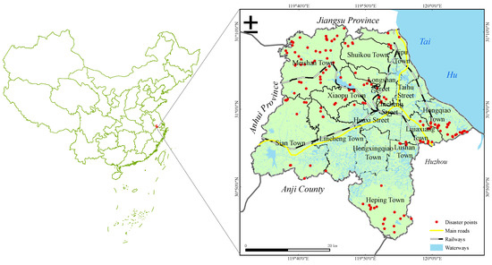
Figure 1.
Geographical location and distribution of disaster points in Changxing County, Zhejiang Province.
Up to May 2021, there were 152 historical disaster points in Changxing County, including 64 collapses and 88 landslides. The scale of the geological hazards was mainly small-scale, of which six were medium-scale, 82 were small-scale and the rest were unknown. There was one medium-scale landslide with a potential collapse volume of about 16,000 m3, 33 small-scale landslides with a potential collapse volume varying from 8 m3 to 4500 m3. There were five medium-scale landslides with a potential landslide volume of 13,000 m3 to 244,800 m3 and zero small-scale landslides with a potential landslide volume of 50 m3 to 64,600 m3.
3. Methods and Data
In this study, two scales of the geohazard susceptibility evaluation studies were conducted for the whole study area and the local areas, and the route is shown in the Figure 2.
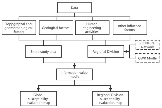
Figure 2.
Flowchart of the methodology used in this study.
3.1. Research Methods
3.1.1. Regional Division
In order to study the differences in the evaluation results of the geological hazard susceptibility based on the information value model at the different spatial scales, a geographically weighted regression model was chosen as the regional division model to carry out the regression analysis on the geological hazard impact factors and the occurred geological hazards in the study area.
The geographically weighted regression (GWR) model is a spatial analysis technique proposed by Fotheringham, which is an extension of the ordinary linear regression model that embeds the geographical location of the data into the regression parameters [30]. Therefore, the geographically weighted regression is an effective mathematical model for dealing with spatial non-stationarity with the following expressions.
where is dependent variable, is the kth explanatory variable of the ith group, is the number of samples, is the coordinates of the ith sample point (e.g., latitude and longitude coordinates), is the kth regression parameter for the ith sample point as a function of the geographic location and εi is the random error of the ith sample point.
The regression parameter is usually estimated using the least squares method:
where is the nth order diagonal matrix, depending on the chosen spatial weight function. The Guass function was chosen as the spatial weight function in this study.
Gauss function method:
where b is the bandwidth and is the distance between the sample points i and j.
3.1.2. The Information Value Model
The information value model is a very popular bivariate statistical method with clear physical meaning, simple operation and high practicality, which can better solve the quantitative evaluation of the geological hazards with numerous factors that are difficult to quantify. It is a quantitative evaluation model that reflects the magnitude of the contribution of the different evaluation factor classes on the occurrence of the geological hazards through the statistical analysis of the relationship between the historical geological hazard data and each evaluation factor. The geological hazard information value Iij can be expressed as:
In the formula:
Iij—the amount of the information value on the occurrence of the geological hazards under the jth class for the ith evaluation factor
Nij—the number of geological hazards occurring under the jth class for the ith evaluation factor
N—the total number of known geological hazards in the study area
Sij—The area of the ith evaluation factor in the jth class
S—the total area of the study area
The total amount of the information value in the evaluation unit is given by Equation (5):
The total information value I is used to determine the susceptibility level of the unit. The higher the total information value of the evaluation factors within the evaluation unit, the higher the possibility for the occurrence of geological hazards.
3.2. Selection of Susceptibility Evaluation Factors
The occurrence of geological hazards is influenced by a combination of basic geological and environmental conditions (e.g., topography, geomorphology, geological conditions) and predisposing factors (e.g., earthquakes and human activities). In this study, with reference to the relevant research results [35,36,37,38,39,40,41] and taking into account the situation of the geological hazards in the study area, we initially selected topographic and geomorphological factors, including the aspect, elevation, curvature, ground roughness, relief amplitude and slope; geological factors, including the lithology and distance from faults; and human engineering activity factors, including the height of the cut slope and other influencing factors in the normalized difference vegetation index (NDVI) for the multiyear average rainfall. There were eleven evaluation factors in total. In order to avoid data redundancy and influences on the accuracy of the evaluation model, the Pearson correlation coefficient was calculated. The Pearson correlation coefficient varies from −1 to 1. When its absolute value |r| is closer to 1, it means that the linear relationship between the two factors is higher. When the absolute value of the coefficient is 1, the two factors can be well described by the linear equation. The relationship between the Pearson correlation coefficient and correlation is divided into three levels. When 0 ≤ |r| < 0.3, the two factors have low correlation; when 0.3 ≤ |r| < 0.8, the two factors have medium correlation; when 0.8 ≤ |r| < 1, the two factors have high correlation. In the susceptibility evaluation studies, when there is a moderate or high correlation, one of the evaluation factors should be removed to eliminate the correlation. The Pearson correlation coefficients between the evaluation factors are shown in Table 1. The Pearson correlation coefficient between the relief amplitude and the elevation and slope was greater than 0.3 and less than 0.8, with a moderate correlation. In addition, slope was an important factor affecting the stability of the slope rock and soil mass. The elevation reflected the relief amplitude in the study area to some extent and the slope and elevation were commonly used, in most studies, for the vulnerability evaluation. Therefore, relief amplitude was finally removed and 10 evaluation factors were retained to establish an evaluation index system. The data sources are shown in Table 2.

Table 1.
Pearson correlation coefficient matrix for each evaluation factor.

Table 2.
Data sources.
The evaluation factor data in this study consisted of continuous and discrete types. The elevation, curvature, surface roughness, slope, NDVI, cut slope of the height and the rainfall were continuous data, which were classified by the Jenks natural break optimization. The Jenks natural breaks optimization is a data clustering method designed to determine the best arrangement of the values into different classes. This is done by minimizing each class average deviation from the class mean, while maximizing each class deviation from the means of the other groups. In other words, the method reduces the variance within the classes and maximizes the variance between the classes. In addition, the aspect was also continuous data, but it had an accepted grading standard in geography and real life, graded in a total of eight directions: north, northeast, east, southeast, south, southwest, west and northwest. The lithology was discrete data and the original natural grouping was used for the classification. For the distance factor from the fault, according to the principle that the closer to the fault, the more prone to geological disaster, a buffer was established and the classes of each evaluation factor are shown in Figure 3. In this study, a 200 m × 200 m raster cell was used as the evaluation cell. Since there were two types of data, raster data and vector data, all the data needed to be converted into the divided evaluation cell based on the ArcGIS. First, the vector data were converted into raster cells using a polygon to raster tool. Second, the raster type data were assigned to each evaluation cell in the study area using a zonal statistics tool according to the impact of the evaluation factors on geohazards, as shown in Table 3.
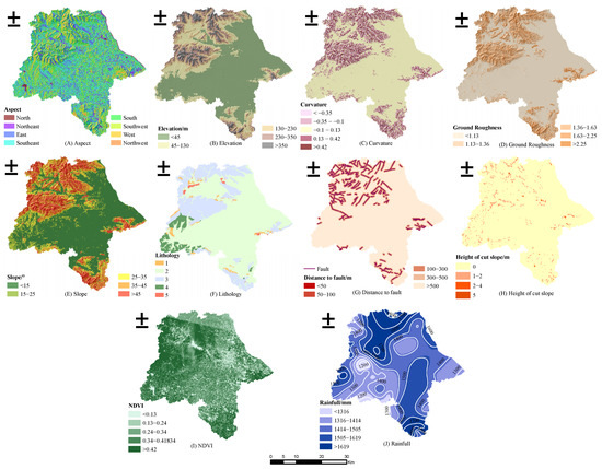
Figure 3.
Classification diagram of each evaluation factor.

Table 3.
Global and regional information value of each evaluation factor.
3.2.1. Topographical and Geomorphological Factors
The aspect indirectly affects the slope stability. The slopes with different aspects have great differences in light time, light intensity and rainfall. Therefore, the vegetation coverage and soil moisture on the slope body are different, which in turn affect the slope stability. The elevation is an important factor that affects the occurrence of the geological hazards, reflects the degree of the terrain fluctuation in the study area and determines the stress in the geotechnical body on the slope, the scale and the speed of the geological hazards and the size of the empty face. The curvature is used to represent the distorted change of the slope surface. If the curvature is positive, the slope is convex. If the curvature is negative, the slope is concave. If the curvature is zero or close to zero, the surface is flat or the terrain is gentle. The ground roughness is an indicator that reflects the surface undulation changes and the degree of erosion. The surface roughness is generally defined as the ratio of a surface element on the surface area to its projected area on the horizontal plane. The higher the roughness, the more severe the erosion and the more likely it is to trigger geological hazards. The main influence of the slope on the occurrence of the geological hazards is to determine the distribution of the stress in the geotechnical body on the slope, to affect the surface runoff, groundwater level and accumulation of loose slope deposits and to affect the human engineering activities impacting the slope stability.
3.2.2. Geological Factors
The rock and soil mass is the material basis for the occurrence of geological hazards. The different rock and soil mass types differ in their resistance to weathering and erosion, affecting the degree of the development of geological hazards in the study area. Based on the stratigraphic lithology of Changxing County, according to the degree of the rock hardness, the rocks are classified into five categories (1−5), which correspond to: rocks that are hard and structurally intact; rocks that are relatively hard and less structurally intact; rocks that are relatively broken and have mosaic structures; rocks that are broken and have soft structural surfaces and rocks that are exceptionally broken and have continuous soft structural surfaces, as shown in Figure 3F.
The geological structure controls the weak structural plane and the slopes near the fault are often concentrated in the development of geological hazards. Once affected by the inducing factors, geological hazards are more likely to occur.
3.2.3. Human Engineering Activities and Other Influencing Factors
Human activities are one of the many factors that induce geological hazards, including cutting slopes and building roads or houses. The higher the height of the cut slope, the greater the probability of slope instability and the occurrence of geological hazards. Vegetation can have a greater impact on the stability of slopes by fixing the soil through the root system and increasing the shear strength of the soil. Rainfall is one of the important influencing factors that influences geological disasters. The perennial rainfall changes the stability of the rock-soil mass and, in the case of heavy or continuous rainfall in the rainy season, the increase in the self-weight of the slope body and groundwater recharge can cause the shear strength between the slide bed and landslide body to decrease, which increases the possibility of a collapse or a landslide.
3.3. Evaluation Factor Importance Judgement
In the 1980s, J. Moody and C. Darken proposed a structural model for neural networks, also known as the radial basis function networks (RBF networks), in which three layers of feedforward neural networks are included. The RBF networks are local approximation networks that offer unparalleled advantages in terms of both input and output. The RBF network model can also measure the importance of the features by varying each feature in turn and by the final prediction of the model [42,43].
Therefore, in this study, the RBF neural network model was used to measure the importance of each evaluation factor, as shown in Figure 4, to ensure that the selected evaluation factors had an impact on the occurrence of the geological hazards in the evaluation of the geological hazard susceptibility. The results showed that the importance of each factor was greater than 0.05, indicating that the selected factors had an impact on the occurrence of the geological hazards in the study area. All nine evaluation index factors were brought into the evaluation model.
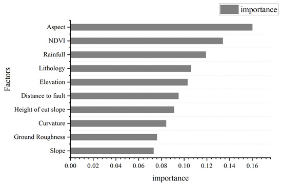
Figure 4.
Evaluation factors importance ranking chart.
The results of the importance ranking of each evaluation factor in the global scale showed that the aspect and the NDVI were the top two ranked evaluation factors. This indicated that, in the scale of the global overall scope, the vegetation cover and soil moisture of the different aspect slopes were very different and the sunny slope was more prone to geological hazards due to the rapid rock weathering rate and high rainfall. Therefore, the aspect contained the influence of many environmental and geological factors on the occurrence of the geohazards, and its influence was the greatest. The NDVI was the second most important evaluation factor, which reflected the surface vegetation cover. Since the study area was heavily vegetated, the shear strength of the soil and the direct scouring effect of the rainfall on the slope body were greatly influenced by the vegetation. Therefore, the vegetation cover had a great influence on the stability of the slope body. The remaining eight evaluation factors had more regional characteristics on the occurrence of the geohazards. The rainfall increased from the central plain to the northwest (Meishan town) and the south (Heping town) hilly mountains. Faults mainly developed in Meishan town, Lijiaxiang town and other areas. The closer to the fault, the more likely geohazards are to occur. Therefore, the fault had less impact on the global scope of geohazards, but a greater impact on the local area. The cut slopes were mainly scattered at the foot of some slopes, which only had an impact on the stability of specific slopes. Therefore, it was urgent to analyze the impact of each evaluation factor on each local area from a regional scale.
4. Results
In this study, two scales of the geological hazard susceptibility evaluation were carried out in the study area. First, an information value model was constructed to evaluate the susceptibility of the geological hazards in the whole study area. Second, because the geological hazards are a natural phenomenon, their occurrence and distribution are characterized by spatial non-stationarity, nonlinearity and uncertainty. In order to improve the accuracy of the geological hazard susceptibility evaluation by the information value model and more fully consider the influence of the geological hazard influencing factors in the different local areas on the susceptibility to the geological hazards, this study used the geographically weighted regression model to analyze the spatial distribution of the important factors of the geological disasters. According to the results of the autocorrelation analysis, the study area was divided into local areas with a low spatial autocorrelation for each evaluation factor. An information value model was established for each local area and the evaluation results of the geological hazard susceptibility in each local area were summarized to obtain the evaluation results of the geological hazard susceptibility under the condition of the regional division.
4.1. Global Susceptibility Evaluation Based on the Information Value Model
The information values of the ten evaluation factors were calculated by using the information value model for the whole study area of Changxing County. The information value was superimposed to obtain the total information value of the evaluation unit (Table 3) and the total information value was used as the susceptibility index. Finally, the geological hazard susceptibility was divided into the following five classes: very low, low, moderate, high and very high using the Jenks natural breaks classification method (Figure 5).
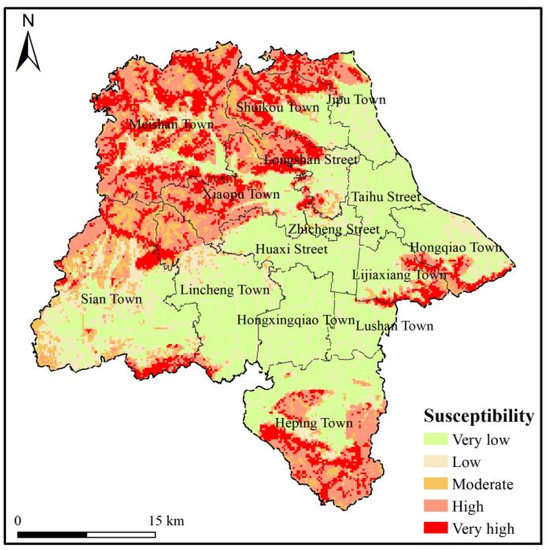
Figure 5.
Global susceptibility evaluation zone map.
4.2. Local Areas Susceptibility Evaluation Based on the Regional Division Information Value Model
The geographic weighted regression coefficients of the evaluation factors were obtained by using the geographic weighted regression module in the ArcGIS software. Since the regression coefficients of the geographically weighted regression were functions of the geographical location (Figure 6), the regional division results with low spatial autocorrelation of each evaluation factor were obtained. The geographically weighted regression coefficients of each evaluation factor were classified according to the Jenks natural breaks classification method to ensure that the geographically weighted regression coefficients of the different categories differed greatly, that is, that the spatial autocorrelation was low. In order to comprehensively consider the influence of the local area geological hazard impact factors on the geological hazard susceptibility, the following principles were adopted for the regional division.
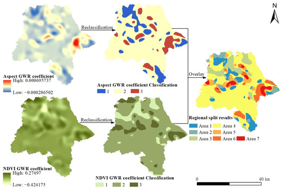
Figure 6.
Schematic diagram of the regional divide.
The process of dividing the local areas ensured that each area had distributed disaster points. Theoretically, the classification results of all the evaluation factors of the geographically weighted regression coefficients were superimposed to obtain the regional division results. To avoid the situation of too fine local areas and raster cells as a local area, the top two evaluation factors in terms of importance, i.e., slope direction and NDVI, were chosen as this regional divide factor.
Each factor was classified into three categories by using the Jenks natural breaks classification method and the classification results of all the evaluation factors with geographically weighted regression parameters were superimposed and manually revised to obtain the final regional division results (Figure 6). The total information value of each grid cell was calculated for each local area using the information value model (Table 3). After combining the results of the calculations for the entire study area, the geological hazard susceptibility was divided into the following five classes: very low, low, moderate, high and very high (Figure 7).
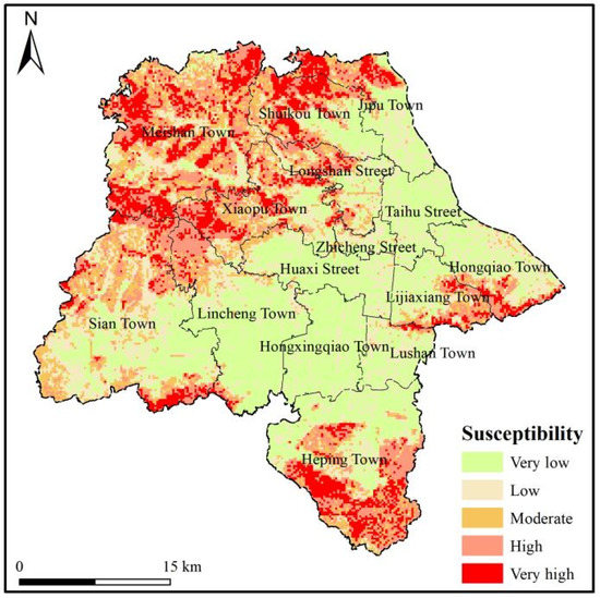
Figure 7.
Regional division-information value model susceptibility evaluation zone map.
The changes in information values, the graded area of each evaluation factor and the distribution of hazard points at the global level and in each local area are shown in Figure 8. The Asp b, Asp c, Asp d, Asp e, Asp f, Asp g, Asp h; Ele a, Ele b, Ele c, Ele d, Ele e; Cur a, Cur b, Cur c, Cur d, Cur e; GR a, GR b, GR c, GR d, GR e; Slo a, Slo b, Slo c, Slo d, Slo e; Lit a, Lit b, Lit c, Lit d, Lit e; DFF a, DFF b, DFF c, DFF d, DFF e; HCS a, HCS b, HCS c, HCS d; NDVIa, NDVIb, NDVIc, NDVId, NDVIe; RAIN a, RAIN b, RAIN c, RAIN d, RAIN e, correspond to each evaluation factor classification, as shown in Table 3.
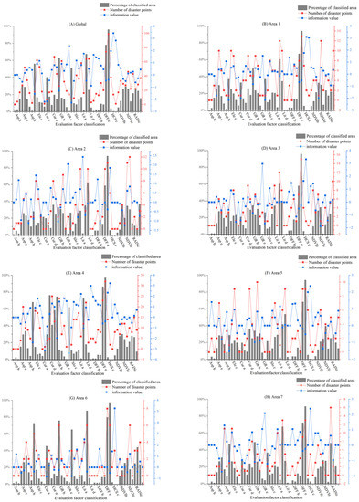
Figure 8.
The amount of the information value and the distribution of disaster points in the evaluation factor classification.
4.3. Model Validation
In order to assess the accuracy and the prediction ability of the global information value model and the regional division-information value model, the receiver operating characteristic curve (ROC) was used to verify the accuracy of the two models in this study. Based on the confusion matrix, the precision, recall and F1 scores of the two models were calculated.
The closer the ROC curve is to the upper left, the higher the accuracy of the prediction result. The area of the curve and the X-axis are usually used to measure the accuracy of the prediction result. The larger the AUC value, the higher the prediction accuracy. The longitudinal axis of the ROC curve represents the true positive rate (sensitivity) and, in the geological hazard susceptibility evaluation, it represents the cumulative percentage of the real geological hazards in each susceptibility level in the study area. The transverse axis represents the false positive rate (specificity) and, in the assessment of the susceptibility to geological hazards, it represents the accumulation plus the percentage of each susceptibility level in the study area. From the ROC curve (Figure 9), the AUC values of the global information model and the regional division information value model were 0.852 and 0.893, respectively. The results showed that the regional-scale segmentation information model improved the prediction accuracy of the information value model.
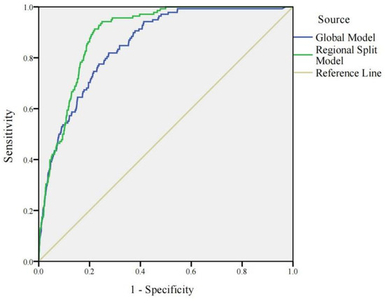
Figure 9.
ROC curve.
The precision is specific to the predicted outcome and represents the probability of an actual positive sample out of all the samples evaluated as positive, representing the overall prediction accuracy, including the positive and negative samples. In this study, all the historical hazard points were selected as the positive samples and the non-hazard points with the same number of historical hazard points were randomly selected as the negative samples based on the ArcGIS random selection tool. The highest susceptibility level occurring in the 3 × 3 neighborhood of the positive sample was selected as the prediction result of this sample and the lowest susceptibility level occurring in the 3 × 3 neighborhood of the negative sample was selected as the prediction result of this sample. The recall was for the original sample, i.e., the probability of a positive sample being predicted in an actual positive sample, and was used to measure whether a positive sample was missed in the prediction result. The F1 value is the summed average of the accuracy and recall, which is equivalent to the combined evaluation index of precision and recall. The core idea of the F1 is to increase the precision and recall as much as possible while also decrease the difference between the two as much as possible. In this study, the accuracy, recall and F1 values of the global informativeness model and the regional-scale segmentation informativeness model were calculated separately, as shown in Table 4. The results show that the regional-scale segmentation informativeness model had a higher accuracy and higher prediction performance.

Table 4.
Precision, recall, and F1 results.
5. Discussion
The geological hazard susceptibility evaluation is the primary task for relevant departments to carry out geological hazard prevention and control. The geographically weighted regression model can provide researchers with a reasonable division of the study area to study the impact of the evaluation factors on the geological hazards in the different local areas. In this study, considering that the geographically weighted regression is a statistical method, there was a lack of consideration for the mechanism of the geohazard occurrence. Therefore, it was necessary to complete the susceptibility evaluation by combining it with an information value model or other models that can reflect the mechanism of the hazard occurrence. As the study area increased, the possible spatial non-stationarity became stronger and the regional division was required. As the area of study area decreased, the spatial non-stationarity tended to be smooth, the autocorrelation of the same evaluation factor was strong, and the degree of impact on the geological hazards was similar, so there was no need for further dividing. For geological hazard susceptibility at the township level and below, individual slopes evaluations are required to improve the accuracy of the susceptibility assessment. Therefore, the application of the geographically weighted regression model in the geological hazard susceptibility level evaluation is applicable to the area dividing at the town level and above.
In this study, the study area was divided into local areas based on the geographical weighted regression model. The changes in the degree of influence of the same evaluation factor on the regional geohazards due to changes in the geographical location were obtained. The change in the importance of the evaluation factors for each of the local areas is shown in Figure 10. Based on the changes in the importance of the evaluation factors, the information value model was used to evaluate the geological hazard susceptibility at two scales. According to the information value results shown in Table 3, the class with the highest information value for each evaluation factor also changed within different locations. For example, the southwest information value was the highest among the aspect classes at the global scale, but the direction with the highest information value among the aspect classes in Area 1 changed to the west, which means that under the global scale, the geological hazards are most likely to occur in the southwest direction, but in the west-central direction in Area 1. Based on the regional division, the change in the contribution of the evaluation factors and the change in the information value of each evaluation factor class after the regional divisions were combined and completed were conducted using a regional scale susceptibility assessment. The changes of the susceptibility zone showed that the susceptibility level of the mountainous area in the southwest of Lijiaxiang and the mountainous area in the north of the Meishan township decreased, while the surface level of the very high susceptibility area in the Shuikou township and the Jiapu township increased. The susceptibility level of some raster units in other townships also changed.
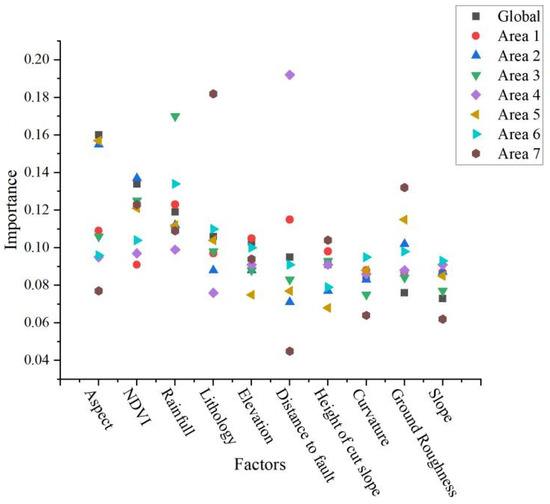
Figure 10.
The importance of evaluation factors varies by region.
Following the statistical analysis, the area of the susceptibility zones and the distribution of the hazard points are shown in Table 5. The susceptibility zoning results of the regional division information value model showed that the area occupied by low and moderate susceptibility areas increased, the area occupied by very low, high and very high susceptibility areas decreased, which yielded susceptibility evaluation results that were more consistent with the actual situation in the study area. Moreover, the number of the historical geological hazard points distributed in the very high susceptibility area increased significantly, so the regional division information model susceptibility zoning was more consistent with the distribution pattern of the historical geological hazard points in the study area, which improved the evaluation accuracy of the traditional global information model.

Table 5.
Result statistics of the susceptibility evaluation.
In this paper, the main limitations were as follows. (1) Landslides and collapses were unified as the geological hazards for the susceptibility evaluation and improved for generalized geohazard susceptibility evaluation. Analyses were conducted on the changes in the degree of influence of the same evaluation factor on the occurrence of geohazards in the different regions, but did not address the degree of influence of the same evaluation factor on the different types of hazards. In future studies, the relationship between the evaluation factors, regional scales and hazard types needs to be comprehensively considered. (2) The regional dividing was achieved through the GWR model and the different splitting models lead to different numbers and shapes of the local areas, affecting the accuracy of the susceptibility evaluation. Therefore, more regional splitting models should be used in order to compare and analyze the influence of the different splitting models on the susceptibility evaluation.
6. Conclusions
(1) Taking Changxing County as the study area and the raster cell as the evaluation unit, nine evaluation factors were selected, including the aspect, elevation, curvature, surface roughness, slope, lithology, distance from fault, height of the cut slope and the normalized difference vegetation index (NDVI). The global and local areas susceptibility of the study area was evaluated based on the ArcGIS platform using the information value model, and the two evaluation results were divided into five classes: very low, low, moderate, high and very high susceptibility.
(2) The regional division information value model provided each evaluation factor in the local area with a low spatial autocorrelation. This model depicted each local area as independent of each other, that is to say, the impact of each evaluation factor on geological hazards was independent of each other. It weakened the influence of some factors that were more important in the global model but less influential in the local area. It better reflected the differences in the contribution of each evaluation factor in the different local areas and accounted for the shortcomings of the global information value model. The evaluation results were more consistent with the changes in the geographic location and geological environment conditions in the study area.
(3) Using the regional division information value model and the global information value model to evaluate the susceptibility of Changxing County, Zhejiang Province, the ROC curve and the spatial distribution of the historical hazard points showed that the regional division information value model had more accurate evaluation results. The AUC values of the global value information model and the regional split-information value model were 0.847 and 0.865, respectively. The regional split-information value model improved the evaluation accuracy of the traditional information model and also had better performance in terms of accuracy and prediction performance. It was more suitable for guiding risk management and disaster prevention and mitigation work. The regional division information value model also showed that the historical geological hazard points were more concentrated in the high and very high susceptibility areas, so the regional division information value model was more consistent with the distribution pattern of the historical geological hazard points in the study area.
Author Contributions
Writing—original draft preparation, methodology, formal analysis and validation Jingru Ma and Xiaodong Wang; writing—review and editing, Guangxiang Yuan. All authors have read and agreed to the published version of the manuscript.
Funding
This research was funded by the National Key Research and Development Program of China (Nos. 2019YFC1509703); Henan Province University Key Scientific Research Project Plan (Nos. 19A170010); Central Plains Science and technology innovation leader Project (Nos. 214200510030); and Key research and development Project of Henan province (Nos. 221111321500).
Data Availability Statement
The test data used to support the findings of this study were provided by the Huadong Engineering Corporation Limited and the Geospatial Data Cloud.
Acknowledgments
The authors of this paper are grateful for the National Key Research and Development Program of China (Nos. 2019YFC1509703); Henan Province University Key Scientific Research Project Plan (Nos. 19A170010); Central Plains Science and technology innovation leader Project (Nos. 214200510030); and Key research and development Project of Henan province (Nos. 221111321500). We also want to express our sincere thanks to the editor and the reviewers for their valuable comments and suggestions for this paper.
Conflicts of Interest
The authors declare no conflict of interest.
References
- Gu, X.B.; Wu, S.T.; Wu, Q.H.; Zhu, Y.H. AHP-Normal Cloud-Model-Based Method for Risk Assessment of Rockfall Hazards in Laoying Yan. Pol. J. Environ. Stud. 2021, 30, 4985–4995. [Google Scholar] [CrossRef] [PubMed]
- Guerriero, L.; Di Napoli, M.; Novellino, A.; Di Martire, D.; Rispoli, C.; Lee, K.; Bee, E.; Harrison, A.; Calcaterra, D. Multihazard susceptibility assessment using analytic hierarchy process: The Derwent Valley Mills UNESCO World Heritage Site case study (United Kingdom). J. Cult. Herit. 2022, 55, 339–345. [Google Scholar] [CrossRef]
- Moustafa, S.S.R.; Al-Arifi, N.S.; Jafri, M.K.; Naeem, M.; Alawadi, E.A.; Metwaly, M.A. First level seismic microzonation map of Al-Madinah province, western Saudi Arabia using the geographic information system approach. Environ. Earth Sci. 2016, 75, 251. [Google Scholar] [CrossRef]
- Zhang, W.; Chen, C.; Huang, Z. Three-mark Matrix Improves AHP Assessment Model and its Application on Geological Hazard Susceptibility. Disaster Adv. 2010, 3, 411–415. [Google Scholar]
- Anaokar, G.S.; Khambete, A.K.; Christian, R.A. Biogas modeling by fuzzy comprehensive index of municipal wastewater and sludge. Environ. Prog. Sustain. Energy 2020, 40, e13502. [Google Scholar] [CrossRef]
- Gokceoglu, C. Discussion on “Combining landslide susceptibility maps obtained from frequency ratio, logistic regression, and artificial neural network models using ASTER images and GIS”. Eng. Geol. 2012, 129, 104–105. [Google Scholar] [CrossRef]
- Pradhan, B. Remote sensing and GIS-based landslide hazard analysis and cross-validation using multivariate logistic regression model on three test areas in Malaysia. Adv. Space Res. 2010, 45, 1244–1256. [Google Scholar] [CrossRef]
- Woo, C.; Kwon, H.; Lee, C.; Kim, K. Landslide Hazard Prediction Map Based on Logistic Regression Model for Applying in the Whole Country of South Korea. J. Korean Soc. Hazard Mitig. 2014, 14, 117–123. [Google Scholar] [CrossRef]
- Xu, C.; Xu, X.; Dai, F.; Wu, Z.; He, H.; Shi, F.; Wu, X.; Xu, S. Application of an incomplete landslide inventory, logistic regression model and its validation for landslide susceptibility mapping related to the May 12, 2008 Wenchuan earthquake of China. Nat. Hazards 2013, 68, 883–900. [Google Scholar] [CrossRef]
- Zhao, X.; Chen, W. Optimization of Computational Intelligence Models for Landslide Susceptibility Evaluation. Remote. Sens. 2020, 12, 2180. [Google Scholar] [CrossRef]
- Quan, H.C.; Lee, B.G. GIS-based landslide susceptibility mapping using analytic hierarchy process and artificial neural network in Jeju (Korea). KSCE J. Civ. Eng. 2012, 16, 1258–1266. [Google Scholar] [CrossRef]
- Tian, Y.; Xu, C.; Hong, H.; Zhou, Q.; Wang, D. Mapping earthquake-triggered landslide susceptibility by use of artificial neural network (ANN) models: An example of the 2013 Minxian (China) Mw 5.9 event. Geomat. Nat. Hazards Risk 2018, 10, 1–25. [Google Scholar] [CrossRef]
- Tsangaratos, P.; Benardos, A. Estimating landslide susceptibility through a artificial neural network classifier. Nat. Hazards 2014, 74, 1489–1516. [Google Scholar] [CrossRef]
- Binh Thai, P.; Dieu Tien, B.; Prakash, I. Bagging based Support Vector Machines for spatial prediction of landslides. Environ. Earth Sci. 2018, 77, 146. [Google Scholar]
- Kumar, D.; Thakur, M.; Dubey, C.S.; Shukla, D.P. Landslide susceptibility mapping & prediction using Support Vector Machine for Mandakini River Basin, Garhwal Himalaya, India. Geomorphology 2017, 295, 115–125. [Google Scholar] [CrossRef]
- Orhan, O.; Bilgilioglu, S.S.; Kaya, Z.; Ozcan, A.K.; Bilgilioglu, H. Assessing and mapping landslide susceptibility using different machine learning methods. Geocarto Int. 2020, 37, 2795–2820. [Google Scholar] [CrossRef]
- Pham, B.T.; Prakash, I.; Chen, W.; Ly, H.-B.; Ho, L.S.; Omidvar, E.; Tran, V.P.; Bui, D.T. A Novel Intelligence Approach of a Sequential Minimal Optimization-Based Support Vector Machine for Landslide Susceptibility Mapping. Sustainability 2019, 11, 6323. [Google Scholar] [CrossRef]
- Yu, L.; Cao, Y.; Zhou, C.; Wang, Y.; Huo, Z. Landslide Susceptibility Mapping Combining Information Gain Ratio and Support Vector Machines: A Case Study from Wushan Segment in the Three Gorges Reservoir Area, China. Appl. Sci. 2019, 9, 4756. [Google Scholar] [CrossRef]
- Kim, J.C.; Lee, S.; Jung, H.-S.; Lee, S. Landslide susceptibility mapping using random forest and boosted tree models in Pyeong-Chang, Korea. Geocarto Int. 2018, 33, 1000–1015. [Google Scholar] [CrossRef]
- Sun, D.; Wen, H.; Wang, D.; Xu, J. A random forest model of landslide susceptibility mapping based on hyperparameter optimization using Bayes algorithm. Geomorphology 2020, 362, 107201. [Google Scholar] [CrossRef]
- Ba, Q.; Chen, Y.; Deng, S.; Wu, Q.; Yang, J.; Zhang, J. An Improved Information Value Model Based on Gray Clustering for Landslide Susceptibility Mapping. ISPRS Int. J. Geo-Inf. 2017, 6, 18. [Google Scholar] [CrossRef]
- Fan, L.; Hu, R.; Zeng, F.; Wang, S.; Zhang, X. Application of weighted information volume model in the evaluation of landslide susceptibility-An example in Enshi City, Hubei Province. J. Eng. Geol. 2012, 20, 508–513. [Google Scholar]
- Singh, K.; Kumar, V. Landslide hazard mapping along national highway-154A in Himachal Pradesh, India using information value and frequency ratio. Arab. J. Geosci. 2017, 10, 539. [Google Scholar] [CrossRef]
- Zhao, J.H.; Chen, H.-L.; Yang, S.F. Comparison of models for hazard assessment of landslide. J. Ziran Zaihai Xuebao/J. Nat. Disasters 2006, 15, 128–134. [Google Scholar]
- Lam, N.S.-N.; Quattrochi, D.A. On the Issues of Scale, Resolution, and Fractal Analysis in the Mapping Sciences. Prof. Geogr. 1992, 44, 88–98. [Google Scholar] [CrossRef]
- Soeters, R.; Van Westen, C.J. Slope instability recognition, analysis and zonation. Landslides Investig. Mitig. 1996, 247, 129–177. [Google Scholar]
- Cascini, L. Applicability of landslide susceptibility and hazard zoning at different scales. Eng. Geol. 2008, 102, 164–177. [Google Scholar] [CrossRef]
- Flentje, P.N.; Miner, A.; Whitt, G.; Fell, R. Guidelines for landslide susceptibility, hazard and risk zoning for land use planning. Aust. Geomech. J. 2007, 42, 13–36. [Google Scholar]
- Wei, C.; Qiang, X.; Jusheng, T. Methodology for evaluating susceptibility to landslides under strong seismic conditions at large scale evaluation scales. J. Hunan Univ. Sci. Technol. Nat. Sci. Ed. 2011, 26, 32–36. [Google Scholar]
- Qin, W.Z. Basic Theory and Applied Research on Geographically Weighted Regression. Ph.D. Thesis, Tongji University, Shanghai, China, 2007. [Google Scholar]
- Kupfer, J.A.; Farris, C.A. Incorporating spatial non-stationarity of regression coefficients into predictive vegetation models. Landsc. Ecol. 2006, 22, 837–852. [Google Scholar] [CrossRef]
- Propastin, P.A. Spatial non-stationarity and scale-dependency of prediction accuracy in the remote estimation of LAI over a tropical rainforest in Sulawesi, Indonesia. Remote Sens. Environ. 2009, 113, 2234–2242. [Google Scholar] [CrossRef]
- Sabokbar, H.A.F.; Roodposhti, M.S.; Tazik, E. Landslide susceptibility mapping using geographically-weighted principal component analysis. Geomorphology 2014, 226, 15–24. [Google Scholar] [CrossRef]
- Windle, M.J.; Rose, G.A.; Devillers, R.; Fortin, M.-J. Exploring spatial non-stationarity of fisheries survey data using geo-graphically weighted regression (GWR): An example from the Northwest Atlantic. ICES J. Mar. Sci. 2010, 67, 145–154. [Google Scholar] [CrossRef]
- Fan, Z.; Gou, X.; Qin, M.; Fan, Q.; Yu, J.; Zhao, J. Information and logistic regression models based coupling analysis for susceptibility of geological hazards. J. Eng. Geol. 2018, 26, 340–347. [Google Scholar]
- Gao, R.; Wang, C.; Liang, Z.; Han, S.; Li, B. A Research on Susceptibility Mapping of Multiple Geological Hazards in Yanzi River Basin, China. ISPRS Int. J. Geo-Inf. 2021, 10, 218. [Google Scholar] [CrossRef]
- Chen, H.; Yang, J.; Xiang, M. Geographic Information System and Weighted Information Value Assessments of Geologic Hazards in Maoxian County, Sichuan. Sci. Technol. Eng. 2021, 21, 12490–12499. [Google Scholar]
- Luo, S.; Wang, S.; Fu, D. Assessment on the susceptibility of sudden geological hazards in mountainous areas of Beijing. Chin. J. Geol. Hazard Control 2021, 32, 126–133. [Google Scholar]
- Van Westen, C.J.; Castellanos, E.; Kuriakose, S.L. Spatial data for landslide susceptibility, hazard, and vulnerability assessment: An overview. Eng. Geol. 2008, 102, 112–131. [Google Scholar] [CrossRef]
- Zhu, W.; Hao, Z.; He, M.; Wang, J. Research on Geological Disaster Susceptibility Division Method Based on BP Neural Network. Resour. Environ. Eng. 2021, 35, 840. [Google Scholar]
- Zhang, X.; Liu, X.; Zhao, Z.; Wu, W. Comparative study of geological hazards susceptibility assessment: Constraints from the information value+ logistic regression model and the CF+ logistic regression model. Geoscience 2018, 32, 602. [Google Scholar]
- Herrera, L.; Pomares, H.; Rojas, I.; Guillén, A.; Rubio, G.; Urquiza, J. Global and local modelling in RBF networks. Neurocomputing 2011, 74, 2594–2602. [Google Scholar] [CrossRef]
- Nabney, I.T. Efficient training of RBF networks for classification. Int. J. Neural Syst. 2004, 14, 201–208. [Google Scholar] [CrossRef] [PubMed]
Disclaimer/Publisher’s Note: The statements, opinions and data contained in all publications are solely those of the individual author(s) and contributor(s) and not of MDPI and/or the editor(s). MDPI and/or the editor(s) disclaim responsibility for any injury to people or property resulting from any ideas, methods, instructions or products referred to in the content. |
© 2023 by the authors. Licensee MDPI, Basel, Switzerland. This article is an open access article distributed under the terms and conditions of the Creative Commons Attribution (CC BY) license (https://creativecommons.org/licenses/by/4.0/).