Article

Coupling a Physical Replica with a Digital Twin: A Comparison of Participatory Decision-Making Methods in an Urban Park Environment

1
Department of Landscape Architecture, Tianjin University, Tianjin 300072, China
2
Department of Architecture, National University of Singapore, Singapore 119077, Singapore
*
Author to whom correspondence should be addressed.
ISPRS Int. J. Geo-Inf. 2022, 11(8), 452; https://doi.org/10.3390/ijgi11080452
Submission received: 14 July 2022 / Revised: 11 August 2022 / Accepted: 17 August 2022 / Published: 19 August 2022

Abstract

:
Public participation is crucial in promoting built environment quality. By using Nancuiping park in China as a case study, this research brings attention to the digital twin park compared to the physical replica in a participatory workshop. Using UAV oblique photography, we created a digital twin model of this park and divided it into six layers to better manage and analyze the environment. Bracing the ‘bottom-up’ design philosophy, in the workshop, we analyzed existing issues in the park and simulated built environment changes, taking suggestions and comments from participants into account to support the decision-making of the park’s optimization. Our digital twin model and physical replica were assessed through a questionnaire in which 59 participants used 3 defined indicators: usability, interactivity, and scenario simulation and visualization quality. The results suggest that the physical replica is easier to use in the participatory design. However, the digital twin model can provide better interactivity and efficient scene simulation and visualization quality. The statistical analysis of the relationship between participants’ feedback on the two models and their sociodemographics (age, gender, and education background) shows that age is a barrier to promoting digital twins for older participants. Meanwhile, the digital twin’s highly interactive features and high-resolution visualization capability were attractive to the younger and well-educated participants. Our study indicates future directions to improve the urban digital twin by incorporating human feedback into the urban model, thus establishing a two-way interaction between the digital system, the physical environment, and human perceptions.

1. Introduction

Urban parks are critical public spaces for physical and recreational activities [1,2], and they are also one of the primary elements of urban ecosystems and urban landscapes [3,4,5,6]. Thanks to the growth of the urban population and its social need for public open green spaces, we have witnessed an increasing demand for more citizen-centric landscape design, environmental conservation, and facility management in parks [7,8].
How to integrate human–environment interactions (e.g., feedback and sentiments) into environmental design or landscape renewal of urban parks is a problem being studied by various disciplines. Public participation is increasingly important in urban renewal practices as a result of urbanization, leading to a growing focus on creating a contemporary governance structure [9]. The concept of public involvement is emphasized in the participatory urban renewal strategy so that citizens can actively participate in environmental management operations [10,11,12]. Such a concept is based on communication, sharing, cooperation, and coordination, and it can give the general public the freedom to live their own lives and unleash their creative potential [13]. The early involvement of citizens in the participatory process is crucial to developing eye-level communication mechanisms between professionals and local residents, which alternates residents from the role that can only passively accept landscape changes to the active designer of the local environment [14]. The participatory workshop is the most common way for individuals to participate in such a participatory practice [15,16]. Through the joint participatory workshop of multiple subjects (e.g., residents, designers, and local governments), the communication between different urban governance parties in the area can be effectively improved [17].
Most studies on built environment participatory projects primarily use physical models (i.e., physical replicas) or 2D maps as tools to interact with the general public and simulate urban changes [18]. As important as these tools are, we have witnessed an increasing number of studies using digital equipment and models (e.g., virtual 3D models) for better communication and simulation [19]. Virtual models offer the participatory process the potential of remote evaluation and near real-world sensing and perception [19]. However, most of these 3D models adopted grey boxes (without texture information) which were distinct from the actual landscapes [20]; that is, this simplified virtual 3D grey box environment cannot capture the entire essence of the built environment. Therefore, whether such models can be considered a proper tool to evoke participants’ perceptions of the actual environment is questionable.
Meanwhile, thanks to the fast development of the digital twin (a virtual representation that serves as the real-time digital counterpart of a physical object or process), studies on virtual perception based on such trending techniques are proliferating [21,22]. A digital twin takes a high-precision 3D virtual model as the digital base and integrates the attribute data (e.g., from physical sensors) of numerous objects in the physical space [23]. It can achieve near real-time data communication between a digital replica and the physical environment, which can support the decision-making process of environmental management for designers, residents, and the government [24]. For the participatory workshop in the context of the digital twin, high-precision replicas of the physical environment are key to encouraging public engagement and environmental scenario simulation [24,25,26,27].
The digital twin model and physical replicas have the common ground of simulating built environment changes and, therefore, assisting the decision-making process in environment optimization [19,28,29]. The digital twin model can achieve remote virtual display using virtual reality display devices (smartphone, tablet, VR glasses, etc.) [30], while the physical model is mainly displayed on site [19]. Existing research on landscape design has often focused on a single technique of practice. To the full extent of our knowledge, no research has compared and collaboratively used two such models for environmental simulation. Meanwhile, no study has been conducted on using built environment digital twin technology for participatory urban park analysis and design. Furthermore, there is still a dearth of in-depth investigation on constructing a precise urban digital twin system that can function as a two-way interactive communication channel in ‘digital system—social perception—physical environment’, especially in the urban park context.
We conduct this research on an urban park in Tianjin, China to show the use of digital twin models in landscape design and to compare and also bridge physical replicas and 3D digital models for broader coverage of public participation. In short, our study questions are threefold:
  • How do we build a digital twin system of urban parks to support scenario simulation and spatial decision making in a participatory workshop?
  • What are the differences in the participants’ evaluations when comparing the digital twin model with the physical replica?
  • How do participants’ evaluations of the two models associate with their sociodemographics?
This paper is structured as follows. In Section 2, we review the state-of-the-art studies of the concept and method of participatory design and the digital twin system. Section 3 describes the case study area, methodology and the participatory park workshop description. Section 4 follows with an elaboration of the findings. Section 5 follows with discussions and insights into the practical implication and directions for future research. Finally, Section 6 concludes the whole paper.

2. Background and Related Work

2.1. The Concept and Method of Participatory Design

The planning system, created by the British Urban and Rural Planning Act in 1947, was the forerunner to public participation in contemporary urban design and planning [31]. It encourages and enables the general public to voice their ideas and needs for urban development during the design process [32]. Participatory design, as an approach, is more democratic than the traditional ‘top-down’ design because it allows the public to shape places based on individual living experiences and redesign the local landscapes [33]. Presently, the ways of urban design, planning, and renewal in most Chinese cities are dominated by government guidance and policies [34,35]. The government-led design and planning often neglect the needs of residents, which can lead to unequal expression of interests in the local communities. Thus, social democracy is unavoidably overlooked [36,37]. In contrast, the ‘bottom-up’ concept rooted in the participatory approach offsets such a defect. Such participatory designs incorporate the views of professional planners, residents, governments, and other communities to cooperatively improve public spaces in the built environment and achieve the Sustainable Development Goals [38,39]. The consideration of ‘people’ is the core concept of the participatory approach, aiming to satisfy the needs of every ‘person’ in the design process [40]. Therefore, the participatory concept is essential to promoting social democracy. Although such a concept is still in its early stages, participatory design has gained increasing support from people with different backgrounds sround the world [38,41].
A large body of research has demonstrated participatory workshops to be the primary method for urban design [42,43,44]. The workshop for a particular area is often an intense multi-day design process, during which a group of experts and residents jointly develop planning strategies, taking feedback and sentiments from the general public into account [45]. Collaborations that involve, for example, urban designers, residents, and local authorities can collect in-depth knowledge about the landscape under study [10]. The workshop often includes visualizations in the form of physical or digital replicas and brainstorming on the design plans. As such, the workshop offers practical ways to take big groups on board, promote more interactive collaboration, and actively collect feedback on every minor detail [17,19]. Design, analysis, and negotiation are the three interconnected elements of this collaborative workshop [32]. The participatory design workshop operation requires an environment where everyone can equally express opinions and actively contribute to the discussions. Previous studies have affirmed that such interactive discussions and collaborative designing activities benefit urban planning and preserve public coherence [46,47]. Therefore, the regeneration of urban areas through participatory workshops has become one of the key strategies for urban development [10,45].

2.2. Digital Twin System and Virtual Participation

Recent studies have increasingly placed their interests in the methodology development of digital visualization to encourage interactive communications, such as 3D visualization [44,48]. Compared with conventional visualization methods such as construction plans, sections, and perspectives, near real-world 3D digital models can provide a better visualization effect [19]. A digital twin is a digital replica of a physical object, and this concept was first introduced by the National Aeronautics and Space Administration (NASA) as a paradigm for future NASA and U.S. Air Force vehicles [49,50]. The digital twin concept is becoming popular thanks to the rapid development of technologies that render the two-way interaction between digital replicas and the physical environment possible [24,51,52]. The 3D model can visualize spatiotemporal information in space, which allows the pre-simulation of the urban planning initiatives to identify their strengths and weaknesses before changing the physical environment [24,53]. Those technologies open up opportunities for the human to sense urban places in the digital models, thus suggesting the potential to encourage participation from the general public in the urban planning process [20,54,55,56,57]. With the proliferation of digital twin studies, the oblique photography data that can be integrated into the models are increasingly scattered [58,59]. For example, a solid 3D city model based on geographic data and information, such as a digital elevation model (DEM) or a digital building model provided by regional authorities, serves as the foundation for the digital twin [60]. With unmanned aerial vehicle (UAV) oblique photography, a high-quality digital base plate for the digital twin model can also be created, yielding a fine three-dimensional genuine scene model [61,62]. The advancement of UAV oblique photography, as well as 3D laser modeling approaches, has aided in these multi-regional built environmental studies [63,64]. As a result, the UAV is now a crucial instrument for creating a digital twin city and is vital to investigating and modeling the environment [65].
We have witnessed previous studies creating digital twins of urban streets, rivers, and other locations using digital technologies [20,57]. These techniques have become crucial tools for environmental analysis and simulating physical changes on the ground. However, using digital twins for urban park participatory workshop studies has rarely been explored.

3. Methodology and Study Area
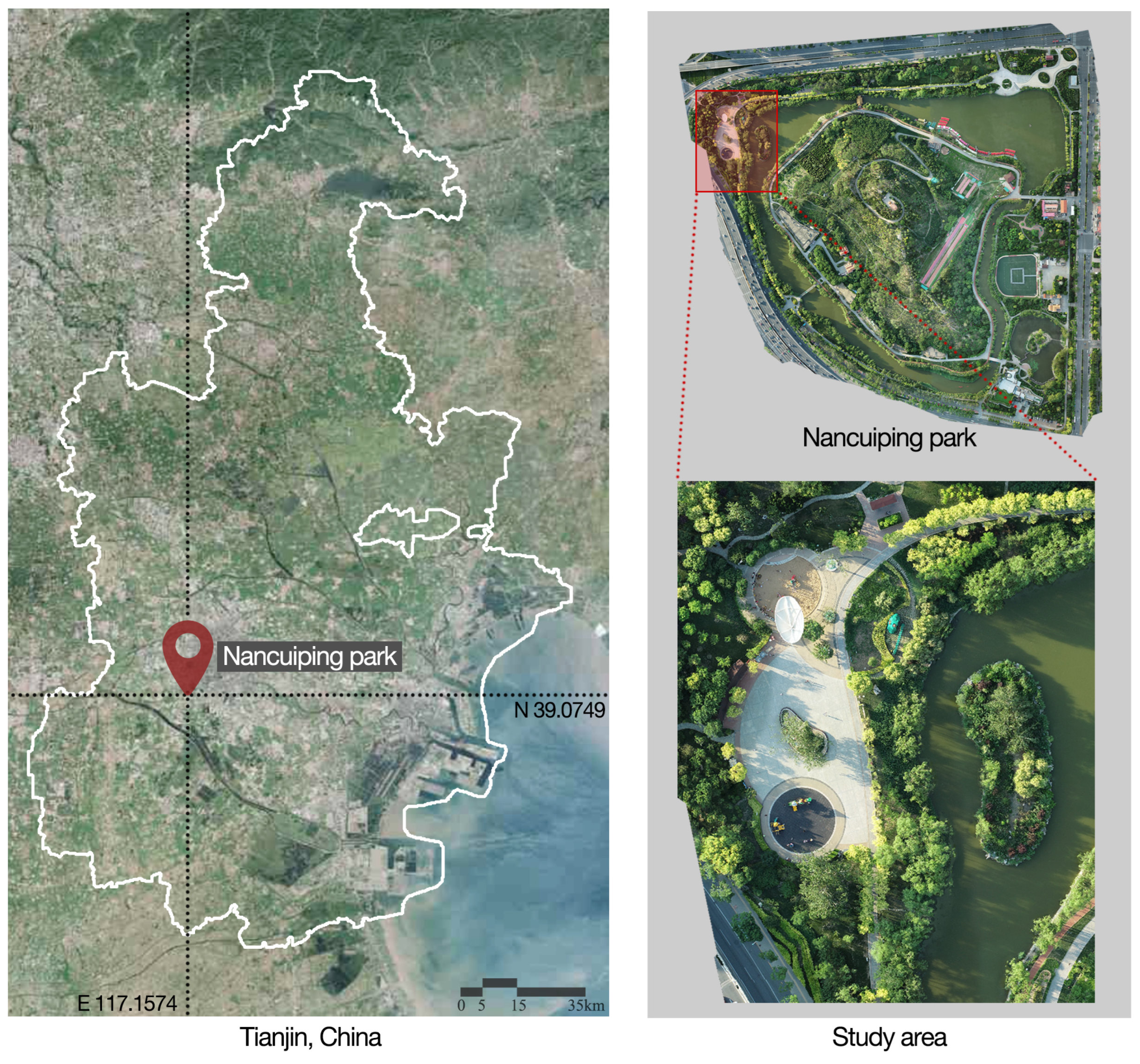
3.1. Study Area

Nancuiping Park, a large-scale urban park with an area of about 14,500 square meters, is located in Tianjin in northern China, a metropolitan city with over 10 million people. This park serves as an important open space that attracts a variety of public activities from residents. However, the park has identified existing issues. For example, public facilities are dilapidated, making them difficult to match with the growing needs of visitors. Our study area was situated northwest of the park, with a playground for kids, fitness facilities, several leisure amenities, and landscape sculptures (Figure 1). The reason why we chose our selected case study area instead of the whole park is that our study area is considered the most crowded and vital location in the park. It attracts most people to visit and have their recreational activities in the park. That aside, the whole park is too large to demonstrate a proof of concept, and it is labor-intensive to create both an information- and semantic-rich digital twin and a physical replica of the park.

3.2. Digital Twin Park Construction

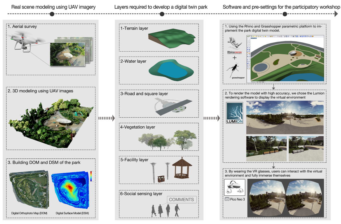
3.2.1. Real Scene Modeling Using UAV Oblique Photography

To address the first research question, we start by describing the steps carried out to construct the digital twin park model. Unmanned aerial vehicle oblique photography is an aerial survey and 3D modeling method that reconstructs the ground objects and landscapes using multiple oblique photos taken from different angles [66,67]. This approach can demonstrate the texture information of different objects and generate a high-precision 3D replica of the ground’s surface with geographical information [68]. This study used the DJI Phantom 4 RTK drone as the oblique imagery acquisition device. Such a drone is equipped with a 1-inch complementary metal oxide semiconductor (CMOS) sensor with 20 million effective pixels. The steps of UAV oblique photography modeling are as follows:
1.
Aerial survey: To reduce the effect of shadows on the 3D accurate scene model, we flew the drone on cloudy days when the solar altitude angle was larger than 30 degrees for aerial surveys. During the survey, we set 300 flight routes (a course overlap rate of 80% and a side overlap rate of 70%) with a flying altitude of 30 m. Flying route planning was carried out through the DJI RTK app, and 7200 aerial images with positioning and orientation system (POS) information were obtained.
2.
Aerial triangulation: We then imported the aerial images from the previous step with POS information into ContextCapture software. We used the oblique photos taken from different angles to reconstruct 3D models of ground objects.
3.
3D modeling: We divided the site model constructed from the previous step into 10 tiles to build a mesh model of the area. The oblique images automatically mapped the texture information. Consequently, we generated a near real-world 3D model of the park, as shown in Figure 2.

3.2.2. Digital Twin Park Design

A digital twin model of the urban park builds on several layers of information, and it takes the 3D accurate scene model based on UAV oblique photography as the base. Inspired by White et al. [24], we defined six layers in our digital twin park model as shown in Figure 2, namely the terrain layer, water layer, road and square layer, vegetation layer, facility layer, and social sensing layer. Among them, the social sensing layer’s data primarily originated from the participatory workshop that asked participants to provide feedback on the park. The remaining five layers’ data were primarily derived from the high-precision 3D model that was gathered by the UAV aerial survey. The terrain layer, which collects topographical data by removing objects such as public buildings and plants, is the foundation of the park’s digital twin. Through manual measurement, several voids in spatial information were filled in, and the relevant void area was given attributes such as material and size to mimic the physical environment. The water body formed the second layer. The roads and squares, which are primarily made of hard-surface paving materials, are the third layer. The fourth layer is the vegetation, which mainly includes trees and shrubs in the area. The fifth layer is the facilities, including lights, trash cans, seats, pavilions, sculptures in the landscape, and so on.

3.2.3. Software and Pre-Settings for the Participatory Workshops

Our study used the Rhino and Grasshopper parametric platform to implement the park’s digital twin model [69]. We manually assigned matching attributes in Grasshopper after layering the 3D model created by the UAV based on various semantic information. For example, trees and shrubs in the park were categorized as the vegetation layer, while the public seats and outdoor sculptures were categorized as the facilities layer. To render the model with high accuracy, we chose the Lumion rendering software to display the virtual environment [70]. Furthermore, we linked Lumion with Rhino through the lumion livesync plug-in. As such, when we adjusted the digital twin model in Rhino, the Lumion software could re-render the visual display nearly in real time, and thus the display efficiency was greatly improved. The Lumion software supports both virtual reality and animation rendering. We presented the virtual environment using iPads and VR glasses (head-mounted displays) so that the participants could interact with these devices and the digital twin environment. By wearing VR glasses, the users could interact with the virtual environment and fully immerse themselves in the experiments. The users saw a rendered scene from a first-person perspective, and the VR equipment provided near real-world experiences for the participants, leading to better perception qualities.

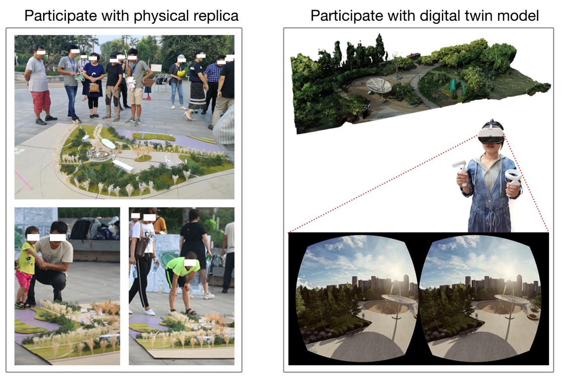
3.3. Physical Replica Construction

The physical replica used in the participatory workshop was a mixture of different landscape components with their spatial characteristics to represent the actual environment [71] visually. The scale of our physical replica was 1:100, including the same 6 layers as the digital twin model: terrain, water, road and square, vegetation, facility, and social sensing, as shown in Figure 3. The replica was produced by 12 graduate students majoring in landscape architecture from Tianjin University. The model used polystyrene foam to create park amenities, including benches, pavilions, and landscape sculptures, while 3-meter-square wooden plates were used to construct the entire physical replica base. Trees, shrubs, grasses, and other realistic items were also placed simultaneously. As a source of data for the social perception layer, we used post-it notes and other tools (e.g., pushpins and plastic tape), which the participants could use to mark important information on the model. The participants could write down the issues they identified on post-it notes and then posted them to specific areas of the physical replica. Such a physical replica illustrates the objective characteristics of the park (object categories, scales, locations, etc.) and can be used for scene simulation by replacing particular objects with other designs (e.g., sculptures, vegetation, buildings, and sports equipment) using foam blocks, colored cardboard, plastic clay, and other materials.

3.4. Participatory Workshop in Nancuiping Park

To answer the second and third research questions, we describe here the steps given to conduct the participatory workshop. The workshop was jointly organized by Tianjin University, Chung Yuan Christian University, the management department of Nancuiping Park, and the local authority of Nankai District in Tianjin (Figure 4). Our goal was to analyze the existing problems in Nancuiping Park through the ‘bottom-up’ participatory workshop and model scenario changes according to the suggestions and comments from different participants to support the decision making of the park’s optimization. We set up several advertising stations in three nearby communities (Long bin yuan, Shidai Aocheng, and Jin gu yuan) to attract residents who knew the park to participate in our workshop. In total, 59 residents joined this workshop, and they had enough knowledge about this park. Among the participants, the mean age was 35.3 years, including 8 people older than 60 and 16 people younger than 20, of which 59.3% were female (n = 35). Meanwhile, 12 people had education backgrounds at primary school or below, 11 people were at a junior high school education level, 14 were at a high school education level, 16 had undergraduate-level degrees, and 6 had postgraduate education and above.
The participants were divided into two groups: one was involved with the digital twin model, and the other used a physical replica (Figure 3). The participants were free to choose whichever they were comfortable with after trial experiments for both approaches. The digital twin model group consisted of 32 individuals, comprising 14 males and 18 females. The youngest participant was 7 years old, the oldest was 71, and the average age was 30. The children’s participation was ensured to have their guardians present and accompanied through the study. We believe that despite the children’s young ages, as the target audience of the playground, their comments on the facilities are insightful for environmental improvement, and their voices should not be ignored [72,73,74,75]. Among all participants for the digital twin model group, 12 participants had education backgrounds below high school (6 with primary school backgrounds and 6 with junior high school degrees). The rest of the participants had education backgrounds of high school or higher; in particular, 10 people had undergraduate degrees, and 2 had educations at the postgraduate level or above. The physical model group consisted of 27 individuals, with 10 males and 17 females. The participants ranged in age from 7 to 68 years old, with an average age of 41.5 years. Sixteen participants had educations at the high school level or above (10 with bachelor’s degrees and 4 with postgraduate degrees or above), and 11 participants’ education levels were below the high school level. The participants in the digital twin group mainly used tablets (iPad) and VR glasses (Pico Neo 3) to interact with the virtual environment. Through virtual post-it notes in the Rhino environment, users added the environmental issues they discovered and suggested solutions for improving the landscape in the digital twin model. Under the supervision of our experiments’ assistants, the participants could alter the landscape setting in the virtual world to model landscape changes. Participants in the physical replica group used colored cardboard, plastic foam, and other materials to make landscape sculptures, seats, and other objects and placed them accordingly for scenario simulation. After the workshop, the participants were asked to complete a questionnaire on the digital twin and physical models. The questionnaire adopted a seven-point Likert scale for indicators to evaluate the usability, interactivity, and scenario simulation and visualization quality of the model (one for the least preferable and seven for the highest preference). The evaluation indicators of these two models were further compared with the participants’ sociodemographics (age, gender, and education background).

4. Results

4.1. Participation Results

Residents from nearby communities commented on the issues they encountered every day and pointed out areas where the park could be improved. After collectively summarizing these comments and identifying the issues, we held three rounds of conversations for both the physical replica and digital twin to understand the existing problems and improvement directions better. To facilitate discussions, we used paper and digital post-it notes to position the environmental issues and suggestions for park improvement in the physical replica and digital twin models, respectively. Such a process has been crucial in improving the park’s environment.
After comparing the two models, we collected the environmental issues raised by the two groups of participants and discovered that those issues overlapped. Almost all of them pointed out the following problems: the park benches and other facilities were dilapidated, and seats in certain areas were damaged with no seat backs. In addition, it was also identified that some facilities in the children’s playgrounds were monotonous with no parent–children interaction space. The landscape sculpture that functioned as a parasol was already crumbling, which could have potential safety hazards and lead to a negative landscape impression for the park. The digital and physical replicas also thoroughly pointed out the issue of the absence of bike parking and other issues.
We used a physical replica and a digital twin model to simulate the park changes based on the above-mentioned issues. Together with these participants, more than 20 graduate students who majored in landscape architecture designed the playground equipment, park benches, and other facilities that required changes. The participants provided our experts with comments regarding the issues they discovered and pointed out the needs to be satisfied. In return, these experts gave the participants technical support for the models. For example, the professionals used Rhino software to produce children’s recreational facilities and Lumion for scene simulation and a visual display for the digital twin model group participants. Meanwhile, the physical replica group used a series of props to make various park facility models for scenario simulation.
Finally, the two groups discussed the content of future landscape design schemes. As shown in the Figure 5, the workshop participants worked together to design seats with backrests and redesigned landscape sculptures with sunshade functions. Regarding the design and selection of children’s recreational facilities, 12 children in the workshop collaborative selected facilities such as slides, log cabins, and seesaws.

4.2. Statistical Analysis

As mentioned in Section 4, We collected evaluations from the participants regarding the usability, interactivity, and scenario simulation and visualization quality for the physical replica and the digital twin model after the workshop. The average usability score for the group of digital twin models was 4.156, and the standard deviation was 1.238. Interactivity had an average score of 6.188 and a standard deviation of 0.738. The standard deviation was 0.780, and the mean score for the scenario simulation and visualization quality was 6.188. Meanwhile, the average usability score of the physical model group was higher than that of the digital twin group, which was 5.444, and the standard deviation was 0.751. The average scores of interactivity and scene simulation and visualization quality were lower than those of the digital twin group, which were 4.111 and 4.074, respectively. For the participants in this study, the physical model was easier to use. In contrast, the digital twin model was superior to the physical model in terms of interactivity and scene simulation and visualization quality.
We illustrated the distribution of three evaluation indicators among participants’ ages and education levels for the digital twin and physical replica (Figure 6). Furthermore, we analyzed the relationship between the participants’ feedback on the two models and their sociodemographics (age, gender, and education background). The correlation coefficient between the digital twin group’s usability and the participants’ age was −0.731 (p < 0.05), indicating a negative correlation. The correlation coefficients between the usability evaluation and gender and education level were 0.039 and −0.116 (p< 0.05), respectively, and the absolute values of the correlation coefficients were less than 0.3, meaning there was almost no correlation. The correlation coefficients between the interactivity of this group and the participants’ genders, ages, and educational backgrounds were −0.119, −0.396, and −0.079 (p< 0.05), respectively, and only the absolute value of the age was more significant than 0.3, which means that there was a moderate negative correlation between interactivity and age. There was almost no link between the scene simulation and display effect scores of this group and the participants’ genders, ages, and educational backgrounds, since the correlation coefficient values were −0.195, −0.284, and −0.092 (p < 0.05), respectively. The correlation coefficients between the usability evaluation value of the physical model group and the genders, ages, and educational backgrounds of the participants were −0.266, −0.379, and −0.391 (p< 0.05), respectively, which means that there was a moderate negative correlation between usability and both age and educational background. There was a little positive correlation between interactivity and age but a slight negative correlation between interactivity and educational background, according to the correlation coefficients between the interactivity evaluation and participant gender, age, and educational background, which were 0.220, 0.302, and −0.355 (p< 0.05), respectively. The correlation values between the evaluation values of the scenario simulation and visualization quality of the physical model and the genders, ages, and educational backgrounds of the participants were 0.274, 0.171, and −0.310 (p< 0.05), respectively, indicating a weakly negative association between educational background and the scenario simulation quality variable.

5. Discussion

The city’s park is inextricably linked to the lives of its inhabitants [76]. The traditional ‘top-down’ expert-dominated way of urban built environment optimization has a trend of being replaced by the ‘bottom-up’ means [10,32,77]. Public participation approaches have attracted broad interest from multiple disciplines [78,79,80]. In this research, we organized a participatory workshop to bring residents into the urban park design process, together with the park management organizations, designers, and local authorities. We showed that such a workshop is not only capable of identifying issues and planning solutions but also a way of prompting built environment justice by involving people with various backgrounds in the project. The contributions of this paper are as follows.
To answer the first research question proposed in Section 1, we built a digital twin model of Nancuiping Park using drone oblique photography. The model was divided into six layers (terrain, water body, vegetation, etc.) to better manage and analyze the environment. Furthermore, we used this virtual model for participatory design and policy decisions by adding several proposed and co-designed objects. This generated additional data that could feed back into the digital twin to identify problem areas in the park that needed to be developed. This study brings attention to the participatory workshop’s urban park digital twin system.
To answer the second research question, we compared the digital twin model and the physical replica using three indicators: usability, interactivity, and scenario simulation and visualization quality. A total of 59 participants rated the scores using a questionnaire. We discovered that the digital twin model was superior to the physical model in terms of interactivity and scene simulation and visualization quality [81]. In contrast, the physical model had advantages in terms of ease of use. The demand for residents’ engagement in public participatory processes requires tools to facilitate communication between different individuals and participatory stimulus processes for efficiency [79]. However, in response to existing studies, our study also shows that the single use of physical models or digital replicas is only the first step to enhancing spatial perception because of the limitations of the characteristics of the means (e.g., usability and interactivity) [19,20,44]. For example, the digital twin model attracts younger people to the participatory processes, especially those familiar with digital devices and technologies. Participants can develop their own ideas in the virtual environment and propose them to the urban planners to facilitate a co-design process as a plan of practice. However, such a co-design process using digital replicas is a barrier for individuals, such as senior citizens or those who are unfamiliar with digital technologies. Our study suggests the effectiveness of physical replicas for such a population group. Thus, our research prompts a combined use of ‘traditional’ physical modeling means and ‘trending’ digital approaches in the public participatory processes. We believe such a combination will benefit the general public.
To answer the third research question, we quantitatively analyzed the relationship between the participants’ evaluations of the two models and their ages, genders, and education levels. The statistical results demonstrate that the older adults gave lower values for usability in the digital twin group versus the higher scores given by younger generations. The comparison suggests that a digital twin model may be more suitable for young people in participatory workshops than a physical model. Such a ‘digital gap phenomenon’ can also be seen in various digital fields and high-tech applications [82,83]. Therefore, lowering the threshold of digital software and applications for the older generation is essential in these public participation projects. Therefore, to ensure everyone’s voice should be heard [84], our research suggests a solution of combining the digital twin model and physical replica for a better participatory planning process.
This research paves the way for enhancing urban digital twins, which incorporates human perception data into the urban environment and creates a two-way coupling between the digital system, the physical environment, and human perception. As was concluded from our research results in Section 5, the digital twin helps researchers better control the physical environment by using digitized models to improve our understanding of the built environment [24]. The digital twin is increasingly being adopted as a tool for urban environmental monitoring, analysis, and simulation [21,85]. Specifically, the digital twin has the following highlights:
  • Collaboration: The digital twin can be a collaborative platform linking residents with urban designers in a participatory workshop. It allows participants to interact with all the objects in the digital twin and tag issues and provide comments on urban design plans to support the decision making of urban designers.
  • High-precision built environment assessment: It organizes spatial and texture information of the built environment into multiple levels, such as plants, water bodies, and roads and squares, thus supporting accurate landscape management and built environment assessment.
  • Solution-driven comparisons: Although the digital twin models can be challenging to be used with the general public in a straightforward manner, from the urban designer’s perspective, the models provide the opportunity for solution-driven comparisons of different designs to find the most suitable plans for urban space planning. The Participation Results section illustrates a range of simulations that can be carried out using a digital twin of the urban built environment, which is conducive to improving the accuracy and interactivity of planning and design.
This study faces some challenges and limitations. First, although we set up several advertising positions in nearby communities to attract residents who knew the park to participate in our workshop, the final number of participants may not be considered big enough. However, it is worth noting that this is a common challenge for many other relevant studies [19,44], although we considered the number of participants we had in this research to be enough to conduct our workshop and deliver research significance. In our future collaboration with Nancuiping Park and studies on other public open spaces, we should consider better advertising strategies to attract more participants. Secondly, in our current experiment, each individual only joined one model group, which may not have been able to provide a full scope of environmental perception. In the future, we plan to encourage participants to use both models (the digital model and the physical replica). We expect that such a process will allow participants to fairly compare each model’s benefits and limitations. Third, in this study, we classified different objects in the 3D real scene model manually according to semantic information in the model constructed by UAV oblique photography, which ensured the accuracy of the digital twin platform. However, this is also relatively time-consuming and laborious. In future research, we plan to use a deep learning algorithm to automatically recognize the semantic information in this data source and classify the objects to improve the existing way of manually classifying objects [86].

6. Conclusions

Participatory design plays a vital role in the renewal and optimization practices of the built environment. With the continuous advancement of urbanization and the improvement of democratic consciousness in China, participatory practices may become the first option for optimizing public spaces in most cities. Most participation research on the built environment focuses on physical replicas or 2D maps as a way to communicate with participants. However, there is no research comparing the environmental simulation capabilities of the physical replicas and digital twin model [19]. As a case study, our study used an urban park in Tianjin, China to showcase our participatory landscape optimization strategy. We coupled the physical replica and 3D digital twin for a collaborative design process. We organized a public involvement workshop and encouraged nearby residents, the local government, university students, park authorities, and others to join in.Through this workshop, we discovered several issues that already existed in the park, including poor conditions for public facilities (e.g., dilapidated seats without backs), a lack of areas for parent–child interaction and bicycle parking, and poor visual effects of landscape sculptures, which are of great significance to the improvement of the park environment. Those issues we found in the workshop commonly exist in urban areas with similar characteristics (e.g., urban parks that need further improvement or renewal) [87,88]. Therefore, we believe this study can be applied to other urban open spaces and benefit other built environment optimization projects.
By comparing the physical replica and digital twin model, we discovered their differences through a questionnaire from three aspects: usability, interactivity, and scenario simulation and visualization quality. Furthermore, we quantitatively analyzed the relationship between the participants’ evaluations of the two models and their ages, genders, and education levels. We concluded that age is a barrier to promoting digital twins to older participants. Meanwhile, the digital twin’s highly interactive features and high-resolution visualization capability are most attractive to younger and well-educated participants. As a result, we can observe that a single method has some limitations. Compared with the physical replica, the digital twin model, for instance, has advantages in scenario modeling but a high use threshold that may not be favorable to elderly individuals or those with less familiarity with digital products. Therefore, we believe that a better participation-based design can benefit from mixed methods. Using solely digital twin models in participatory design workshops may not be appropriate.
From the public participation point of view, the diffusion of interactive and usable digital twins could enable new forms of collaboration between urban planners, residents, authorities, etc. and pave the way for new means of rethinking public spaces. Our paper focused on how to build a digital twin model of urban parks and applied this model as a method of urban spatial decision making in participatory design workshops. Our digital twin can also be used for a range of other design and planning decisions. It also allows for other simulations that require 3D data, such as sunshade analysis in the built environment. Authorities can simultaneously share their future plans with the public, allowing individuals to observe and even explore new design concepts and assess the effects of these plans, such as modifications to sunshades in urban areas. This can then inform the policy of the areas of the space in which to place seats and other facilities. In future works, we also plan to use the state-of-the-art digital twin techniques in other environments (both the built environment and natural settings) to improve our management ability and understanding of the physical world. At the same time, this research may inspire scholars’ interest in learning more about digital twin applications and encouraging public participation in various built environment improvements.

Author Contributions

Conceptualization, Junjie Luo; methodology, Junjie Luo and Pengyuan Liu; software, Junjie Luo; validation, Junjie Luo, Pengyuan Liu and Lei Cao; formal analysis, Junjie Luo; investigation, Junjie Luo; resources, Junjie Luo; data curation, Lei Cao; writing—original draft preparation, Junjie Luo; writing—review and editing, Pengyuan Liu; visualization, Junjie Luo; supervision, Lei Cao; project administration, Junjie Luo; funding acquisition, Junjie Luo and Lei Cao. All authors have read and agreed to the published version of this manuscript.

Funding

This research was funded by the China Scholarship Council under the State Scholarship Fund (grant no. 202106250086) and the National Social Science Foundation of China (grant no. 19ZDA193). This paper is also part of the project Multi-scale Digital Twins for the Urban Environment: From Heartbeats to Cities, which is supported by the Singapore Ministry of Education Academic Research Fund Tier 1.

Institutional Review Board Statement

Not applicable.

Informed Consent Statement

Not applicable.

Data Availability Statement

Not applicable.

Acknowledgments

We thank the members of the Department of Landscape Architecture at Tianjin University for the discussions.

Conflicts of Interest

The authors declare no conflict of interest.

References

  1. Halkos, G.; Leonti, A.; Sardianou, E. Activities, motivations and satisfaction of urban parks visitors: A structural equation modeling analysis. Econ. Anal. Policy 2021, 70, 502–513. [Google Scholar] [CrossRef]
  2. Huai, S.; Van de Voorde, T. Which environmental features contribute to positive and negative perceptions of urban parks? A cross-cultural comparison using online reviews and Natural Language Processing methods. Landsc. Urban Plan. 2022, 218, 104307. [Google Scholar] [CrossRef]
  3. Kabisch, N.; Kraemer, R.; Masztalerz, O.; Hemmerling, J.; Püffel, C.; Haase, D. Impact of summer heat on urban park visitation, perceived health and ecosystem service appreciation. Urban For. Urban Green. 2021, 60, 127058. [Google Scholar] [CrossRef]
  4. Peng, J.; Dan, Y.; Qiao, R.; Liu, Y.; Dong, J.; Wu, J. How to quantify the cooling effect of urban parks? Linking maximum and accumulation perspectives. Remote Sens. Environ. 2021, 252, 112135. [Google Scholar] [CrossRef]
  5. Mäntymaa, E.; Jokinen, M.; Juutinen, A.; Lankia, T.; Louhi, P. Providing ecological, cultural and commercial services in an urban park: A travel cost–contingent behavior application in Finland. Landsc. Urban Plan. 2021, 209, 104042. [Google Scholar] [CrossRef]
  6. Silva, L.T.; Fonseca, F.; Pires, M.; Mendes, B. SAUS: A tool for preserving urban green areas from air pollution. Urban For. Urban Green. 2019, 46, 126440. [Google Scholar] [CrossRef]
  7. Han, D.; Zhang, C.; Wang, C.; She, J.; Sun, Z.; Zhao, D.; Bian, Q.; Han, W.; Yin, L.; Sun, R.; et al. Differences in response of butterfly diversity and species composition in urban parks to land cover and local habitat variables. Forests 2021, 12, 140. [Google Scholar] [CrossRef]
  8. Wang, P.; Zhou, B.; Han, L.; Mei, R. The motivation and factors influencing visits to small urban parks in Shanghai, China. Urban For. Urban Green. 2021, 60, 127086. [Google Scholar] [CrossRef]
  9. leBrasseur, R. Cultural Greenspaces: Synthesizing Knowledge and Experience in Nova Scotia’s African-Canadian Communities through Participatory Research and SoftGIS. Soc. Sci. 2022, 11, 281. [Google Scholar] [CrossRef]
  10. Yang, J.; Yang, L.; Ma, H. Community Participation Strategy for Sustainable Urban Regeneration in Xiamen, China. Land 2022, 11, 600. [Google Scholar] [CrossRef]
  11. Główczyński, M. Toward User-Generated Content as a Mechanism of Digital Placemaking—Place Experience Dimensions in Spatial Media. ISPRS Int. J. Geo-Inf. 2022, 11, 261. [Google Scholar] [CrossRef]
  12. Speller, G.; Ravenscroft, N. Facilitating and evaluating public participation in urban parks management. Local Environ. 2005, 10, 41–56. [Google Scholar] [CrossRef]
  13. Geekiyanage, D.; Fernando, T.; Keraminiyage, K. Mapping participatory methods in the urban development process: A systematic review and case-based evidence analysis. Sustainability 2021, 13, 8992. [Google Scholar] [CrossRef]
  14. McEvoy, S.; van de Ven, F.H.; Blind, M.W.; Slinger, J.H. Planning support tools and their effects in participatory urban adaptation workshops. J. Environ. Manag. 2018, 207, 319–333. [Google Scholar] [CrossRef]
  15. Street, P. Scenario workshops: A participatory approach to sustainable urban living? Futures 1997, 29, 139–158. [Google Scholar] [CrossRef]
  16. Chen, F.; Chen, Y. Urban Metabolism and Spontaneous Architectural Growth: A Sustainable Strategy Featuring Participatory Co-Construction by Multiple Stakeholders. Buildings 2022, 12, 352. [Google Scholar] [CrossRef]
  17. De Siqueira, G.; Malaj, S.; Hamdani, M. Digitalization, Participation and Interaction: Towards More Inclusive Tools in Urban Design—A Literature Review. Sustainability 2022, 14, 4514. [Google Scholar] [CrossRef]
  18. Pánek, J. Emotional maps: Participatory crowdsourcing of citizens perceptions of their urban environment. Cartogr. Perspect. 2018, 91, 17–29. [Google Scholar] [CrossRef]
  19. Postert, P.; Wolf, A.E.; Schiewe, J. Integrating Visualization and Interaction Tools for Enhancing Collaboration in Different Public Participation Settings. ISPRS Int. J. Geo-Inf. 2022, 11, 156. [Google Scholar] [CrossRef]
  20. Schrotter, G.; Hürzeler, C. The digital twin of the city of Zurich for urban planning. PFG–J. Photogramm. Remote Sens. Geoinf. Sci. 2020, 88, 99–112. [Google Scholar] [CrossRef]
  21. Scalas, A.; Cabiddu, D.; Mortara, M.; Spagnuolo, M. Potential of the Geometric Layer in Urban Digital Twins. ISPRS Int. J. Geo-Inf. 2022, 11, 343. [Google Scholar] [CrossRef]
  22. Tzachor, A.; Sabri, S.; Richards, C.E.; Rajabifard, A.; Acuto, M. Potential and limitations of digital twins to achieve the Sustainable Development Goals. Nat. Sustain. 2022, 1–8. [Google Scholar] [CrossRef]
  23. Redelinghuys, A.; Basson, A.H.; Kruger, K. A six-layer architecture for the digital twin: A manufacturing case study implementation. J. Intell. Manuf. 2020, 31, 1383–1402. [Google Scholar] [CrossRef]
  24. White, G.; Zink, A.; Codecá, L.; Clarke, S. A digital twin smart city for citizen feedback. Cities 2021, 110, 103064. [Google Scholar] [CrossRef]
  25. Shahat, E.; Hyun, C.T.; Yeom, C. City digital twin potentials: A review and research agenda. Sustainability 2021, 13, 3386. [Google Scholar] [CrossRef]
  26. Kikuchi, N.; Fukuda, T.; Yabuki, N. Landscape Visualization by Integrating Augmented Reality and Drones with Occlusion Handling to Link Real and Virtual Worlds-Towards city digital twin realization. In Proceedings of the 39th eCAADe Conference, Novi Sad, Serbia, 8–10 September 2021; pp. 521–528. [Google Scholar]
  27. Ham, Y.; Kim, J. Participatory sensing and digital twin city: Updating virtual city models for enhanced risk-informed decision-making. J. Manag. Eng. 2020, 36, 04020005. [Google Scholar] [CrossRef]
  28. Nochta, T.; Parlikad, A.; Schooling, J.; Badstuber, N.; Wahby, N. The Local Governance of Digital Technology–Implications for the City-Scale Digital Twin; Cambridge University: Cambridge, MA, USA, 2019. [Google Scholar]
  29. Charitonidou, M. Urban scale digital twins in data-driven society: Challenging digital universalism in urban planning decision-making. Int. J. Archit. Comput. 2022, 20, 14780771211070005. [Google Scholar] [CrossRef]
  30. Mukhopadhyay, A.; Reddy, G.R.; Saluja, K.S.; Ghosh, S.; Peña-Rios, A.; Gopal, G.; Biswas, P. Virtual-reality-based digital twin of office spaces with social distance measurement feature. Virtual Real. Intell. Hardw. 2022, 4, 55–75. [Google Scholar] [CrossRef]
  31. Taylor, N. Urban Planning Theory Since 1945; Sage: Thousand Oaks, CA, USA, 1998. [Google Scholar]
  32. Li, X.; Zhang, F.; Hui, E.C.m.; Lang, W. Collaborative workshop and community participation: A new approach to urban regeneration in China. Cities 2020, 102, 102743. [Google Scholar] [CrossRef]
  33. Groulx, M.; Lemieux, C.; Freeman, S.; Cameron, J.; Wright, P.A.; Healy, T. Participatory planning for the future of accessible nature. Local Environ. 2021, 26, 808–824. [Google Scholar] [CrossRef]
  34. Enserink, B.; Koppenjan, J. Public participation in China: Sustainable urbanization and governance. Manag. Environ. Qual. 2007, 18, 459–474. [Google Scholar] [CrossRef]
  35. Li, Y.; Cheng, H.; Beeton, R.J.; Sigler, T.; Halog, A. Sustainability from a Chinese cultural perspective: The implications of harmonious development in environmental management. Environ. Dev. Sustain. 2016, 18, 679–696. [Google Scholar] [CrossRef]
  36. Semeraro, T.; Zaccarelli, N.; Lara, A.; Sergi Cucinelli, F.; Aretano, R. A bottom-up and top-down participatory approach to planning and designing local urban development: Evidence from an urban university center. Land 2020, 9, 98. [Google Scholar] [CrossRef]
  37. Sim, T.; Dominelli, L.; Lau, J. A Pathway to Initiate Bottom-Up Community-Based Disaster Risk Reduction within a Top-Down System: The Case of China; WIT Press: Southampton, UK, 2017. [Google Scholar]
  38. El Asmar, J.P.; Ebohon, J.O.; Taki, A. Bottom-up approach to sustainable urban development in Lebanon: The case of Zouk Mosbeh. Sustain. Cities Soc. 2012, 2, 37–44. [Google Scholar] [CrossRef]
  39. Pettit, C.; Nelson, A.; Cartwright, W. Using on-line geographical visualisation tools to improve land use decision-making with a bottom-up community participatory approach. In Recent Advances in Design and Decision Support Systems in Architecture and Urban Planning; Springer: Berlin/Heidelberg, Germany, 2004; pp. 53–68. [Google Scholar]
  40. Pogačar, K.; Žižek, A. Urban hackathon–alternative information based and participatory approach to urban development. Procedia Eng. 2016, 161, 1971–1976. [Google Scholar] [CrossRef]
  41. Li, Y.; Beeton, R.J.; Sigler, T.; Halog, A. Enhancing the adaptive capacity for urban sustainability: A bottom-up approach to understanding the urban social system in China. J. Environ. Manag. 2019, 235, 51–61. [Google Scholar] [CrossRef]
  42. Ortiz Escalante, S.; Gutiérrez Valdivia, B. Planning from below: Using feminist participatory methods to increase women’s participation in urban planning. Gend. Dev. 2015, 23, 113–126. [Google Scholar] [CrossRef]
  43. Lawrence, D.; Christodoulou, N.; Whish, J. Designing better on-farm research in Australia using a participatory workshop process. Field Crop. Res. 2007, 104, 157–164. [Google Scholar] [CrossRef]
  44. Salter, J.D.; Campbell, C.; Journeay, M.; Sheppard, S.R. The digital workshop: Exploring the use of interactive and immersive visualisation tools in participatory planning. J. Environ. Manag. 2009, 90, 2090–2101. [Google Scholar] [CrossRef]
  45. Nikologianni, A.; Betta, A.; Gretter, A. Contribution of Conceptual-Drawing Methods to Raise Awareness on Landscape Connectivity: Socio-Environmental Analysis in the Regional Context of Trentino (Italy). Sustainability 2022, 14, 7975. [Google Scholar] [CrossRef]
  46. Akbar, A.; Flacke, J.; Martinez, J.; van Maarseveen, M.F. The Role of Participatory Village Maps in Strengthening Public Participation Practice. ISPRS Int. J. Geo-Inf. 2021, 10, 512. [Google Scholar] [CrossRef]
  47. Kenny, D.C.; Castilla-Rho, J. No Stakeholder Is an Island: Human Barriers and Enablers in Participatory Environmental Modelling. Land 2022, 11, 340. [Google Scholar] [CrossRef]
  48. Neuenschwander, N.; Hayek, U.W.; Grêt-Regamey, A. Integrating an urban green space typology into procedural 3D visualization for collaborative planning. Comput. Environ. Urban Syst. 2014, 48, 99–110. [Google Scholar] [CrossRef]
  49. El Saddik, A. Digital twins: The convergence of multimedia technologies. IEEE Multimed. 2018, 25, 87–92. [Google Scholar] [CrossRef]
  50. Glaessgen, E.; Stargel, D. The digital twin paradigm for future NASA and US Air Force vehicles. In Proceedings of the 53rd AIAA/ASME/ASCE/AHS/ASC Structures, Structural Dynamics and Materials Conference 20th AIAA/ASME/AHS Adaptive Structures Conference 14th AIAA, Honolulu, HI, USA, 23–26 April 2012; p. 1818. [Google Scholar]
  51. Tao, F.; Cheng, J.; Qi, Q.; Zhang, M.; Zhang, H.; Sui, F. Digital twin-driven product design, manufacturing and service with big data. Int. J. Adv. Manuf. Technol. 2018, 94, 3563–3576. [Google Scholar] [CrossRef]
  52. Mohammadi, N.; Taylor, J. Knowledge discovery in smart city digital twins. In Proceedings of the 53rd Hawaii International Conference on System Sciences, Maui, HI, USA, 7–10 January 2020. [Google Scholar]
  53. Luo, W.; Hu, T.; Zhang, C.; Wei, Y. Digital twin for CNC machine tool: Modeling and using strategy. J. Ambient. Intell. Humaniz. Comput. 2019, 10, 1129–1140. [Google Scholar] [CrossRef]
  54. Havard, V.; Jeanne, B.; Lacomblez, M.; Baudry, D. Digital twin and virtual reality: A co-simulation environment for design and assessment of industrial workstations. Prod. Manuf. Res. 2019, 7, 472–489. [Google Scholar] [CrossRef]
  55. Kuts, V.; Otto, T.; Bondarenko, Y.; Yu, F. Digital twin: Collaborative virtual reality environment for multi-purpose industrial applications. In Proceedings of the ASME International Mechanical Engineering Congress and Exposition. American Society of Mechanical Engineers, Virtual, 16–19 November 2020; Volume 84492, p. V02BT02A010. [Google Scholar]
  56. Singh, M.; Fuenmayor, E.; Hinchy, E.P.; Qiao, Y.; Murray, N.; Devine, D. Digital twin: Origin to future. Appl. Syst. Innov. 2021, 4, 36. [Google Scholar] [CrossRef]
  57. Dembski, F.; Wössner, U.; Letzgus, M.; Ruddat, M.; Yamu, C. Urban digital twins for smart cities and citizens: The case study of Herrenberg, Germany. Sustainability 2020, 12, 2307. [Google Scholar] [CrossRef]
  58. Ruohomäki, T.; Airaksinen, E.; Huuska, P.; Kesäniemi, O.; Martikka, M.; Suomisto, J. Smart city platform enabling digital twin. In Proceedings of the 2018 International Conference on Intelligent Systems (IS), Wroclaw, Poland, 17–18 September 2018; pp. 155–161. [Google Scholar]
  59. Deng, T.; Zhang, K.; Shen, Z.J.M. A systematic review of a digital twin city: A new pattern of urban governance toward smart cities. J. Manag. Sci. Eng. 2021, 6, 125–134. [Google Scholar] [CrossRef]
  60. Shirowzhan, S.; Tan, W.; Sepasgozar, S.M. Digital twin and CyberGIS for improving connectivity and measuring the impact of infrastructure construction planning in smart cities. ISPRS Int. J. Geo-Inf. 2020, 9, 240. [Google Scholar] [CrossRef]
  61. Levine, N.M.; Spencer Jr, B.F. Post-earthquake building evaluation using UAVs: A BIM-based digital twin framework. Sensors 2022, 22, 873. [Google Scholar] [CrossRef] [PubMed]
  62. Lim, S.H.; Choi, K.M.; Cho, G.S. A study on 3D model building of drones-based urban digital twin. J. Cadastre Land InformatiX 2020, 50, 163–180. [Google Scholar]
  63. Mohammadi, M.; Rashidi, M.; Mousavi, V.; Karami, A.; Yu, Y.; Samali, B. Case study on accuracy comparison of digital twins developed for a heritage bridge via UAV photogrammetry and terrestrial laser scanning. In Proceedings of the 10th International Conference on Structural Health Monitoring of Intelligent Infrastructure, Tokyo, Japan, 30 June–2 July 2021; Volume 10. [Google Scholar]
  64. Mihoković, V.; Zalović, L.; Zalović, V. Establishing the utility charges spatial database using digital twin technology. In Proceedings of the 2020 43rd International Convention on Information, Communication and Electronic Technology (MIPRO), Opatija, Croatia, 28 September–2 October 2020; pp. 437–441. [Google Scholar]
  65. Mohammadi, M.; Rashidi, M.; Mousavi, V.; Karami, A.; Yu, Y.; Samali, B. Quality evaluation of digital twins generated based on UAV photogrammetry and TLS: Bridge case study. Remote Sens. 2021, 13, 3499. [Google Scholar] [CrossRef]
  66. Skondras, A.; Karachaliou, E.; Tavantzis, I.; Tokas, N.; Valari, E.; Skalidi, I.; Bouvet, G.A.; Stylianidis, E. UAV Mapping and 3D Modeling as a Tool for Promotion and Management of the Urban Space. Drones 2022, 6, 115. [Google Scholar] [CrossRef]
  67. Lai, F.; Bush, A.; Yang, X.; Merrick, D. Opportunities and Challenges of Unmanned Aircraft Systems for Urban Applications. In Urban Remote Sensing: Monitoring, Synthesis, and Modeling in the Urban Environment; John Wiley & Sons Ltd.: Hoboken, NJ, USA, 2021; pp. 47–69. [Google Scholar]
  68. Wu, B.; Xie, L.; Hu, H.; Zhu, Q.; Yau, E. Integration of aerial oblique imagery and terrestrial imagery for optimized 3D modeling in urban areas. ISPRS J. Photogramm. Remote Sens. 2018, 139, 119–132. [Google Scholar] [CrossRef]
  69. Zhang, Y.; Meina, A.; Lin, X.; Zhang, K.; Xu, Z. Digital twin in computational design and robotic construction of wooden architecture. Adv. Civ. Eng. 2021, 2021. [Google Scholar] [CrossRef]
  70. Hadiyatna, W.; Harapan, A. Use of 3D animation software in visualizing architectural works. In IOP Conference Series: Materials Science and Engineering; IOP Publishing: Bristol, UK, 2020; Volume 879, p. 012147. [Google Scholar]
  71. Saßmannshausen, S.M.; Radtke, J.; Bohn, N.; Hussein, H.; Randall, D.; Pipek, V. Citizen-Centered Design in Urban Planning: How Augmented Reality can be used in Citizen Participation Processes. In Proceedings of the Designing Interactive Systems Conference 2021, Virtual, 28 June–2 July 2021; pp. 250–265. [Google Scholar]
  72. Krishnamurthy, S. Reclaiming spaces: Child inclusive urban design. Cities Health 2019, 3, 86–98. [Google Scholar] [CrossRef]
  73. Carroll, P.; Witten, K.; Asiasiga, L.; Lin, E.Y. Children’s engagement as urban researchers and consultants in Aotearoa/New Zealand: Can it increase children’s effective participation in urban planning? Child. Soc. 2019, 33, 414–428. [Google Scholar] [CrossRef]
  74. Ataol, Ö.; Krishnamurthy, S.; van Wesemael, P. Children’s participation in urban planning and design: A systematic review. Child. Youth Environ. 2019, 29, 27–47. [Google Scholar] [CrossRef]
  75. Smith, F. Children’s Voices and the Construction of Children’s Spaces: The Example of Playcare Centers in the United Kingdom. Child. Environ. 1995, 12, 389–396. [Google Scholar]
  76. Liu, Q.; Zhu, Z.; Zhuo, Z.; Huang, S.; Zhang, C.; Shen, X.; van den Bosch, C.C.K.; Huang, Q.; Lan, S. Relationships between residents’ ratings of place attachment and the restorative potential of natural and urban park settings. Urban For. Urban Green. 2021, 62, 127188. [Google Scholar] [CrossRef]
  77. Li, J.; Krishnamurthy, S.; Roders, A.P.; van Wesemael, P. Informing or consulting? Exploring community participation within urban heritage management in China. Habitat Int. 2020, 105, 102268. [Google Scholar] [CrossRef]
  78. Rakotomahazo, C.; Razanoelisoa, J.; Ranivoarivelo, N.L.; Todinanahary, G.G.B.; Ranaivoson, E.; Remanevy, M.E.; Ravaoarinorotsihoarana, L.A.; Lavitra, T. Community Perceptions of a Payment for Ecosystem Services Project in Southwest Madagascar: A Preliminary Study. Land 2021, 10, 597. [Google Scholar] [CrossRef]
  79. Lock, O.; Pettit, C. Developing Participatory Analytics Techniques to Inform the Prioritisation of Cycling Infrastructure. ISPRS Int. J. Geo-Inf. 2022, 11, 78. [Google Scholar] [CrossRef]
  80. Hettiarachchi, C.J.; Priyankara, P.; Morimoto, T.; Murayama, Y. Participatory GIS-Based Approach for the Demarcation of Village Boundaries and Their Utility: A Case Study of the Eastern Boundary of Wilpattu National Park, Sri Lanka. ISPRS Int. J. Geo-Inf. 2021, 11, 17. [Google Scholar] [CrossRef]
  81. Rzeszewski, M.; Orylski, M. Usability of WebXR visualizations in urban planning. ISPRS Int. J. Geo-Inf. 2021, 10, 721. [Google Scholar] [CrossRef]
  82. Longoria, I.A.I.; Bustamante-Bello, R.; Ramírez-Montoya, M.S.; Molina, A. Systematic Mapping of Digital Gap and Gender, Age, Ethnicity, or Disability. Sustainability 2022, 14, 1297. [Google Scholar] [CrossRef]
  83. Ribeiro, M.M.; Cunha, M.A.; Barbosa, A.F. E-participation, social media and digital gap: Challenges in the brazilian context. In Proceedings of the 19th Annual International Conference on Digital Government Research: Governance in the Data Age, Delft, The Netherlands, 30 May–1 June 2018; pp. 1–9. [Google Scholar]
  84. Healey, P. The communicative turn in planning theory and its implications for spatial strategy formation. Environ. Plan. Plan. Des. 1996, 23, 217–234. [Google Scholar] [CrossRef]
  85. Argota Sánchez-Vaquerizo, J. Getting Real: The Challenge of Building and Validating a Large-Scale Digital Twin of Barcelona’s Traffic with Empirical Data. ISPRS Int. J. Geo-Inf. 2021, 11, 24. [Google Scholar] [CrossRef]
  86. Lehtola, V.V.; Koeva, M.; Elberink, S.O.; Raposo, P.; Virtanen, J.P.; Vahdatikhaki, F.; Borsci, S. Digital twin of a city: Review of technology serving city needs. Int. J. Appl. Earth Obs. Geoinf. 2022, 102915. [Google Scholar] [CrossRef]
  87. Jin, X.; Meifeng, M. Research on the Evaluation of Urban Park Usage (POE). In Proceedings of the 2020 International Conference on Intelligent Design (ICID), Xi’an, China, 11–13 December 2020; pp. 237–243. [Google Scholar]
  88. Xiang, L.; Tian, Y.; Pan, Y. Study on landscape evaluation and optimization strategy of Central Park in Qingkou Town. Sci. Rep. 2022, 12, 1–11. [Google Scholar] [CrossRef] [PubMed]
Figure 1. Nancuiping Park and the study area. Orthophoto maps (left) were taken using UAV photogrammetry. Source of the satellite image (right) taken from Google Maps.
Ijgi 11 00452 g001
Figure 2. Digital twin system design of Nancuiping Park.
Ijgi 11 00452 g002
Figure 3. Two groups of participants. One group was involved with a digital twin model, and the other used a physical replica.
Ijgi 11 00452 g003
Figure 4. Participatory workshop in Nancuiping Park.
Ijgi 11 00452 g004
Figure 5. Examples of designed works in the workshop.
Ijgi 11 00452 g005
Figure 6. Comparison of the distribution of three evaluation indicators among participants’ ages (youth: 18 years old and below; adults: 18–59; seniors: 60 and above) and education levels (high school level or below and undergraduate level or above) on digital twin and physical replica.
Ijgi 11 00452 g006
Publisher’s Note: MDPI stays neutral with regard to jurisdictional claims in published maps and institutional affiliations.

