1. Introduction
Land Administration System (LAS) is a system that registers real estates, their ownership, value, and use. LAS describes real property with physical, spatial, topographic, and thematic attributes. LAS data can informally be divided into two subsets: data describing rights and restrictions on real properties (legal data) and data describing the geometry of real properties (survey data). To support such data diversity, LAS contains two complementary subsystems: land registry and cadaster.
Land registry is an official record of rights related to land or of deeds concerning changes in the legal situation of defined units of land. It answers the questions of who owns particular property and what legal document that ownership is based on [
1].
Cadaster represents a public inventory of data regarding properties within a certain county or district. Data in cadaster are based on a survey of boundaries. It represents a register of spatial data used for describing properties and answers questions about the location of a certain property [
1]. Data that may appear in a cadaster include geometric data (coordinates, maps) [
2,
3,
4], property addresses [
5,
6], land use [
7,
8], real property information, the nature and duration of the tenure, details about the construction of buildings and apartments [
9,
10,
11,
12], and land taxation values [
13,
14]. Furthermore, cadastral data models help to gather and supply relevant information for disaster management [
15], sustainable development [
16], food security [
17,
18], post-conflict administration [
19], and spatial planning [
20].
In ‘Cadaster 2014’ [
21] a vision for a cadaster system ‘without paper and pencil’ is presented. As a result of this research, an international initiative for common data-model development was initiated. The result was the creation of the ISO 19152:2012 Geographic information—Land Administration Domain Model (LADM). The LADM is a conceptual data model that is widely adopted as the descriptive standard for land administration [
22]. Many country profiles and LADM application analyses have been published to date. After ’Cadaster 2014’, the focus of academia is on ’Cadaster 2034’ and what we could expect from LAS in years to come. Research is focused in two directions. The first direction is based on the new technological achievements that could bring survey-accuracy, object-oriented design, 3D/4D arrangements, real-time information, global linkages, and organic characteristics as the main characteristics of future cadasters [
23]. The second direction is related to prioritising important social, legal, and environmental agendas, such as securing basic rights, providing for equity, fairness, transparency, accountability and the rule of law, and government decentralisation [
24].
One of LAS’s tasks is to keep the data up to date with the changes in the real world related to the land administration domain. Those changes include changes of ownership (buying/selling, inheritance), the establishment of rights (such as mortgage), and the division or merging of parcels [
25]. Managing LAS data is conducted by executing transactions that update the land registry and cadastral data. In the digital era, LAS manages legal data describing owners, real estates, and ownership rights and restrictions, such as the owner’s name, parcel area, or the ownership share. On the other hand, LAS also has to manage the survey data that describe real estate shape and position by vector graphics using an appropriate coordinate reference system. Some LASs may contain additional thematic data that describe land usage or similar data describing the purpose of spatial features on the terrain [
26].
There are differences between the LASs in different countries. Land registration systems may be based on deeds or titles. An LAS may be implemented as a dual system, with a separate land book (title holders on real property) and land cadaster (real property) or as a unified system with one register (in some countries it is called real estate cadaster). In both cases, the problem of the integration of the land registry and cadastral data remains an important issue, due to the fact that these two subsystems are loosely coupled. Moreover, both subsystems have their own business rules and transactions [
27].
After the LAS initial state is established by collecting and arranging real-world data, the main activity in LAS management is to keep those data up to date by executing transactions that reflect real-world changes, such as ownership rights changes, new building registration, owner address updates, and so on. These transactions have to maintain data correctness and consistency, which may be violated especially if a transaction spans over both the land registry and cadaster. The analysis presented in [
28] shows an example of the significant inconsistency between data in the land register and cadaster.
ISO 19157:2013 Geographic information—Data quality defines six data quality elements: completeness, thematic accuracy, logical consistency, temporal quality, positional accuracy, and usability [
29]. The data quality should be evaluated on the base of metadata stored together with legal and survey data in LAS. ISO 19115-1:2014 Geographic information—Metadata—Part 1: Fundamentals and ISO 19115-2:2019 Geographic information—Metadata—Part 2: Extensions for acquisition and processing define schema required for describing geographic information and services by means of metadata [
30,
31]. Data quality as well as semantics and terminology still represent the major challenge in contemporary LASs.
Today, in an era of powerful computer systems, LAS efficiently stores, updates, and manages data in digital format. An LAS data update is typically conducted by LAS employees through graphical user interface (GUI) applications. Those applications are developed using various general-purpose languages (GPL). Using GUI applications requires basic computer usage skills but no programming knowledge.
Domain-specific languages (DSLs) are languages developed, as its name suggests, to be used in a specific domain, contrary to GPL. GPLs can be used to build general computer software and typically have great possibilities and flexibility, while DSLs are typically easy to use and write statements, so users must have appropriate domain knowledge and basic programming skills. DSL statements are then translated or interpreted into some GPL statements.
Defining and using DSLs is a kind of model-driven software development. The first step in development is the creation of formal, tool-processable representations of specific aspects of software systems. These representations (DSL statements) can be directly interpreted by interpreters or transformed into GPL statements by code generators [
32].
The motivation for this research was to develop a DSL for the land administration domain so the user can write a statement that will execute as a transaction in the LAS. The research is based on the use case of land administration transactions in Serbia. The Serbian LAS, as well as the LASs of other Western Balkan countries, is based on the Austro-Hungarian land registry and cadaster. There are multiple DSL implementation benefits. DSL statements can be used to execute various complex operations that are difficult to execute using standard GUI applications. The presentation and reporting of DSL statements can be conducted in the same format as they are written. DSL statements can be validated and verified by an appropriate integrated development environment, so the end user efficiency is improved. Those statements are understandable to the user that has no programming knowledge or skills. DSL statements could be translated into multiple-target languages [
33]. This paper proposes DSL for LAS transactions that would enable land administration employees to write statements that would be executed to keep LAS data up to date with real-world changes.
DSL for LAS transaction statement persistence could be implemented in centralized systems, such as database systems, or in a distributed transaction ledger, such as blockchain. Since blockchain technology already provides smart contracts as a mechanism to execute transactions generally, it will be compared with the solution of DSL for LAS transaction statements stored in an arbitrary blockchain.
This paper is organized as follows:
Section 2 gives some theoretical background of the fields of LAS and DSL. Various types of LAS transactions are discussed in
Section 3. In
Section 4, the system architecture for DSL for LAS transactions is discussed. The proposed solution is presented, with examples of LAS transaction statements, in
Section 5. The discussion and future work guidelines are given in
Section 6.
2. Related Work
In 2012, the International Standardisation Organization (ISO) published ISO-19152:2012 Geographic information—Land Administration Domain Model (LADM), which defines a reference domain model for covering basic information-related components of land administration [
22]. LADM does not provide a universal solution suitable for any specific LAS. Instead, it is recommended as a reference for the creation of domain models suitable for a specific country profile. In the domain of geographic information, a profile is a “set of one or more base standards or subsets of base standards, and, where applicable, the identification of chosen clauses, classes, options, and parameters of those base standards that are necessary for accomplishing a particular function” [
34]. As a result, many country profiles based on LADM have been published, such as [
35,
36,
37,
38]. According to [
39] LADM is mainly the focus of academia. The main subjects of research are the creation of new LADM country profiles and how current systems match LADM. In some cases, LADM expanded to add additional layers of data, such as land use [
26], as well as to specify additional constraints that exist in LASs, especially regarding the internal consistency of data between the land registry and cadaster [
27]. Transactions related to LASs are outside the scope of LADM because the transactions being significantly country-specific. The term ’transaction’ is used here to describe the transformation of the state, which has properties of atomicity, consistency, isolation, and durability. In 2018, a New Working Item Proposal for Edition II of LADM was proposed that included multiple extensions, including transactions and the application of blockchain technologies [
36,
40].
In general, transactions in LAS could consist not only of changing the ownership of real estate, establishing rights related to real estate such as mortgages or development and easement rights, and the merging and splitting of real estates, but could also be related to improving the quality of data stored in LAS [
25]. As mentioned, these procedures differ a lot from country to country and have different actors involved. For example in the case of Turkey, the General Directorate of Land Registry and Cadaster performs 25 different cadastral and land registry transactions, requiring different documents from different external institutions [
41]. In the case of Slovenia, the typical transfer of agricultural land involves at least five actors: the seller, buyer, notary, administration office, and LAS and includes the execution of at least 12 steps/activities between actors [
42]. The process of real estate transactions in Sweden also involves several actors: seller, buyer, real estate agents, land administration office, seller, and buyer’s banks and involves 34 steps [
43]. Even with just a few examples, it is clear that the registration of real estate transactions could be a rather complex process, and that it can differ significantly from country to country or, to be more precise, from one legal jurisdiction to another.
ISO Technical Specification (ISO/TS) 19103:2015 (ISO 19103: Geographic information—Conceptual schema language, 2015) defines Unified Modeling Language (UML) as a conceptual schema language for the specification of geographic information [
44]. So, in most cases, UML is used to describe the current process of real estate transactions, usually through class diagrams, use cases, and sequence diagrams. Based on those UML diagrams, contemporary LAS are usually developed as GUI-based applications, with dedicated components for supporting the manipulation of spatial data. This is conducted in some GPLs created for developing software solutions for a variety of different domains. UML and GPL are the main tools for creating software solutions used by IT professionals. Although the processes of land administration transactions in specific legal jurisdictions are different, the actors and activities involved in those processes are similar and could justify the creation of a DSL for LAS transactions.
A DSL represents the programming or specification language that is developed to solve problems in a specific domain. DSLs provide notations and constructs for application in a specific domain, and, as such, DSLs are more expressive and easier to use than GPL. Moreover, compared to GPL, DSL opens up application domains to a larger group of software developers [
45] as well as domain experts. By using DSL, domain experts can be more involved in developing a solution to a problem, because they can more easily understand and validate code and understand what impact a specific change will have [
46]. To go a step further, unlike GPL, DSL is intended for the end user, who does not need to be a software developer; so, the user could perform simple programming tasks, using some macro or scripting language [
47].
Some of the main benefits of DSL are:
DSL makes it possible to express transactions at the level of abstraction of the problem domain and in a way makes it possible for domain experts to understand, validate, modify, and in some cases develop DSL programs;
DSL is self-documented to a large extent for reasons mentioned in the previous statement;
DSL can improve productivity, maintainability, reliability, and portability;
DSL incorporates knowledge about a specific domain of application, in that way preserves it and makes it available for future use;
DSL makes it possible to perform validation and optimization at the domain level [
47].
A DSL can be classified by three dimensions: appearance, origin, and implementation [
45]. Appearance classifies DSL as one of textual, graphical, tabular, or symbolic. According to the origin, a DSL could be internal, developed from existing GPL or DSL, or external, relying on its own infrastructure. Regarding implementation, DSLs are classified as well-known executions, DSLs that serve as input to application generators; non-executable DSLs, which are, nonetheless, useful as input to application generators; and DSLs not designed to be executed [
46].
To the best knowledge of the authors, apart from several papers related to modeling processes in landscapes [
48,
49,
50] and land use [
51,
52], which do not closely related to the research presented in this paper, no research has been conducted on developing DSL in the field of LASs or, more specifically, for managing LAS transactions. By proposing DSL for LAS transactions, a new level of abstraction, statement validation, and possibility of interpretation of various platforms are introduced. Domain experts could perform LAS transactions more easily by writing DSL statements.
3. Land Administration System Transactions
All LAS data may be divided into two main datasets: legal and survey. The different natures of those datasets make transaction execution in the integrated LAS a bit challenging. One of the important tasks of LAS is to keep legal and survey data in a consistent and correct state. Some LAS data, such as a parcel area for example, are recorded in both datasets. It is recorded as a numeric value in the legal dataset and can also be calculated from polygon vertex coordinates from the survey dataset. This redundancy is inherited from legacy LASs that have used analog cadastral maps. Polygon area calculation was not automated and was not possible immediately, so the calculated area was recorded in a legal dataset. This way of recording the same data twice in a different datasets creates the possibility for data inconsistency to occur [
53,
54].
In automated LASs, many inconsistencies between legal and survey data collected from analog sources can be detected by software tools. Legal data are stored in digital form, survey data (analog maps) are digitized, and spatial features are recorded as vector graphic data. A prerequisite for the execution of LAS transactions in an appropriate way by following business rules and constraints is that initial datasets are in a consistent state.
Some LAS transactions are executed in a way that requires several legal and survey CRUD (create, read, update, delete) operations to be executed to finish the whole process. One example of such a transaction is parcel division. The use case scenario for this transaction is as follows:
The user selects a parcel from the legal dataset that should be divided;
The system loads the parcel survey data and shows it on a digital map;
The user divides a parcel using the input data that describe the division line;
The system generates labels and calculates the areas of newly created parcels that are the result of division and commits the transaction in the survey dataset;
Based on newly created parcels in the survey dataset, the system inserts the new parcel data into the legal dataset, including labels, areas, etc., and commits the transaction;
The system deactivates the original parcel that has been divided and commits a transaction in the legal dataset.
In the previous example, in step 2, the legal data are the input for the survey data transaction, and later, in step 4, the survey data are the input for the legal data transaction.
In this paper, changes that include only legal data are referred to as legal transactions. Changes that include only survey data are referred to as survey transactions. In the case that both legal and survey data are being changed, those transactions are referred to as composite transactions.
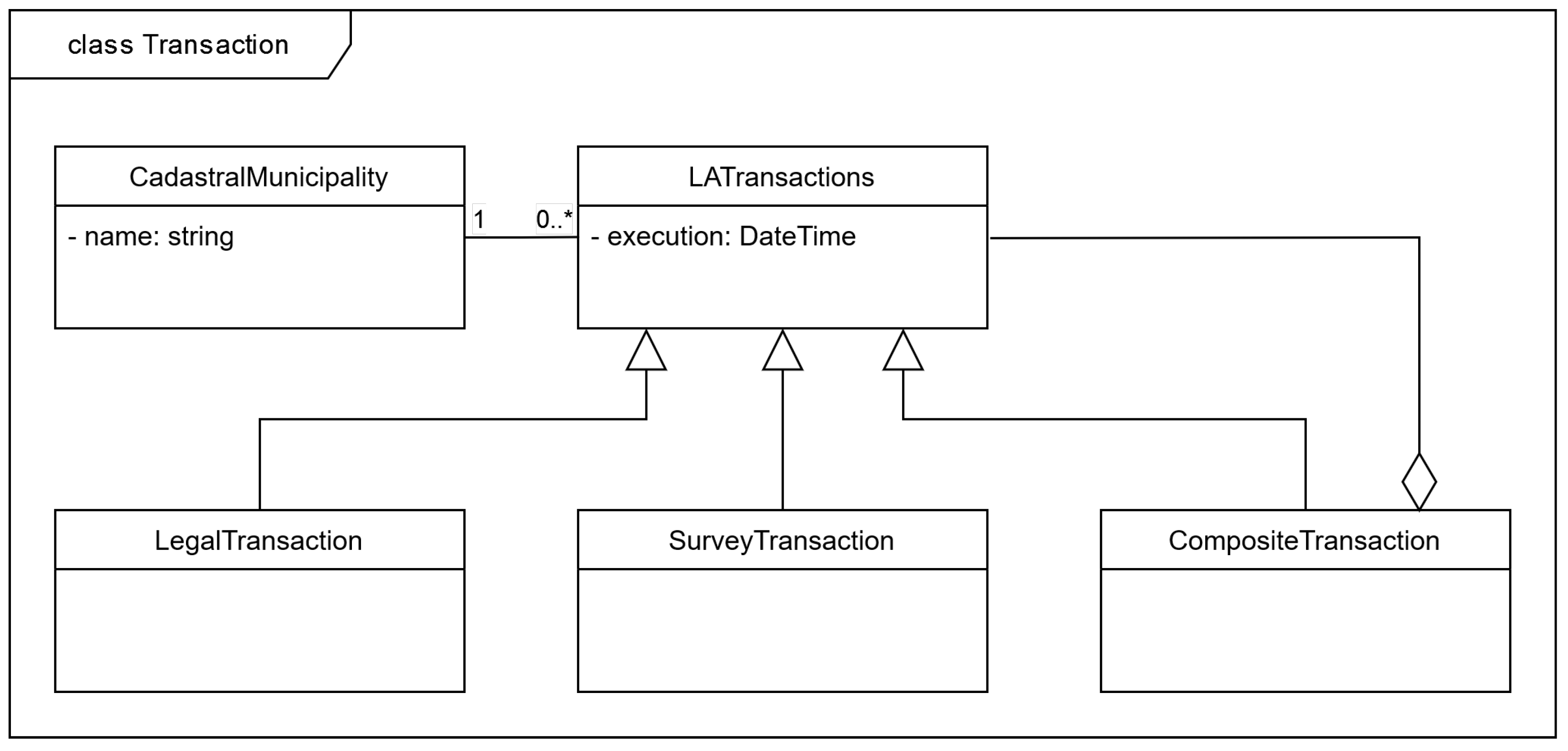
In
Figure 1, the authors are present a UML class diagram for LAS transaction key abstractions from the case study of Serbia.
The class CadastralMunicipality represents the cadastral spatial units that are used to divide the territory into smaller, more easily manageable administrative parts. Changes that take place on the ground are registered within the cadastral municipality. The approach to register one transaction in one cadastral municipality is inherited from the legacy cadastral systems and may cause complications in situations when parcels from more different cadastral municipalities are involved. This problem is usually solved such that more separate transactions are registered, one for each cadastral municipality involved.
One of the requirements for LASs is to keep track of all transactions that took place and, if required by legal authorities, revert some of them and restore the cadastral data in the state prior to the execution of the transaction. A challenge in these situations may be that the data that should be restored are subsequently changed. In these situations, a typical “undo” approach cannot be conducted.
Transactions in LAS may be atomic or composite. To model its structure and execution, a Composite design pattern is used [
55]. This pattern proposes an abstract class Component that has an operation common to its specializations: Leaf for atomic instances and Composite for composite ones. In the case of LAS transactions, the abstract class is LATransaction, and its abstract operation is named execute(); the two atomic classes are LegalTransaction and SurveyTransaction, and the composite one is CompositeTransaction class. By applying a composite design pattern, it is possible to register and execute composite transactions, such as one described in the use case scenario above, in the same way as for atomic transactions.
3.1. Legal Transactions
Typical legal transactions are those that transfer the ownership of real estates from one party to another or add or remove restrictions such as mortgages, changes of land usage, and so on. They may be very simple, such as owner address changes, but they can also be more complex, for example, involving several owners selling their shares of ownership to several different buyers in a different share distribution. These transactions may be a consequence of purchase, gift, inheritance, etc.
3.1.1. Domain Model for Legal Transactions
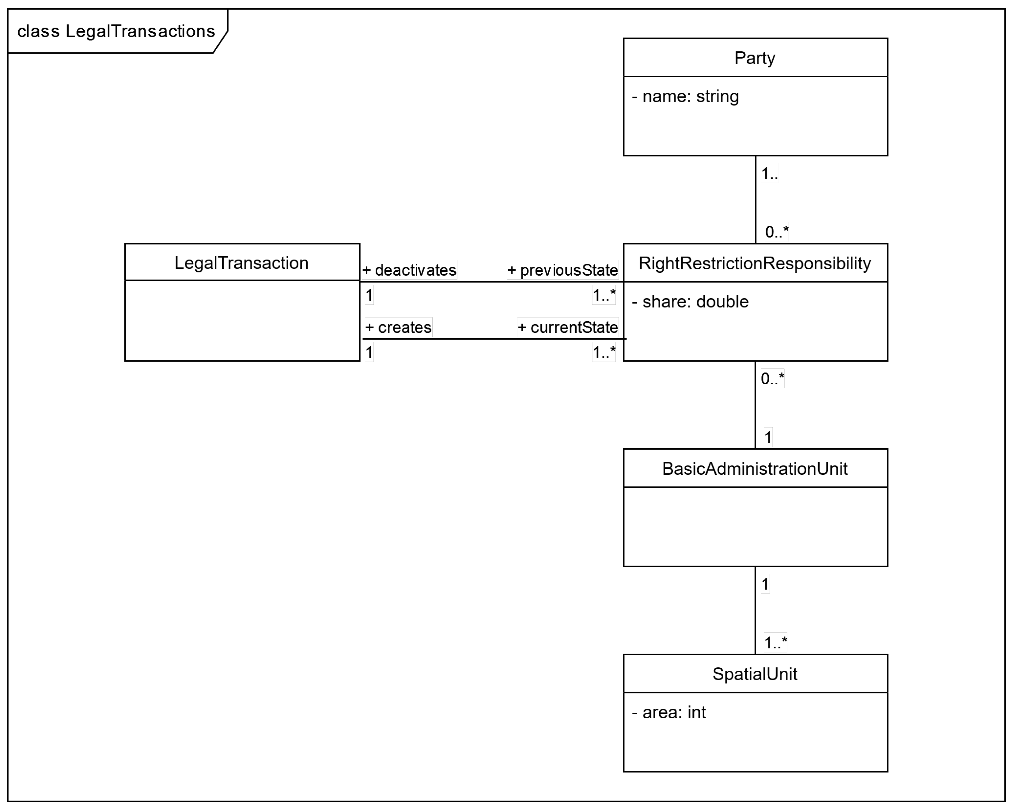
The LAS legal data domain model is shown in
Figure 2. There are a few classes that represent key abstractions.
The class Party represents owners that could be persons or various types of organizations (companies, institutions, etc.). The class SpatialUnit represents real estate that may be a land parcel, building, or part of the building (apartment, garage, etc.). The class RightRestrictionResponsibility represents the ownership restriction or responsibility of a party on a spatial unit. Since parties may share relationships on the same spatial unit, an attribute share is defined in the class. The model also contains the class BasicAdministrationUnit, which is common in various cadastral systems. The basic administration unit represents a collection of rights, responsibilities, and restrictions with the same ownership relationships. For example, if party p1 has an exclusive right to spatial units su1 and su2 (share 1), these two rights would be grouped in one basic administration unit. If parties p1 and p2 share rights to su3 and su4 in the shares of 0.7 and 0.3, respectively, these rights would be recorded in another basic administration unit. If the same parties, p1 and p2, share half of the rights to the spatial unit su5 each, it would be recorded in another land administration unit.
The concept of a basic administration unit was useful in the legacy cadastral systems to group the collection of rights, responsibilities, and restrictions with the same ownership relationships. Grouped data with the same ownership relationship from the cadastral database can be extracted by executing an appropriate database query on the rights data. It is worth mentioning that, in some cases, digital data might not have the same legal force as the analog data that are still being stored in many national cadasters. Keeping the concept of a basic administration unit in the domain model makes LAS transaction execution a bit more complex since its versioning has to be conducted, too.
The execution of a legal transaction that transfers rights will deactivate all the rights that will be marked as the previous state and create new rights that will present the current state, which will be in effect after the transaction is completed. It is important to note that every right record will have information about which transaction created it and made its current state and which one made it a previous state if any.
3.1.2. Constraints in Legal Transactions
Legal transactions have to conform to constraints and regulations that are defined in the land administration domain. Below are some of them.
The original owners must possess an ownership share of the real estate that is to be transferred.
The ownership share that is to be transferred from the original owners to the new owners must be the same.
The original owners’ ownership will be deactivated but must be saved so it can eventually be restored.
If rights that are to be transferred belong to the basic administration unit that is involved in another transaction that is still not completed, the current transaction execution has to be postponed.
3.2. Survey Transactions
Survey transactions deal with spatial unit geometry data. In two dimensional space, parcel geometry is represented by polygons. Typically, one survey transaction affects a set of parcels that form one connected homogeneous area. In this case, the survey transaction has one outer boundary which may be represented by a closed polyline. There are also cases when parcels affected by a survey transaction are not all connected, so the survey transaction has more outer and inner boundaries. So, here we will introduce the term “transaction boundaries”, which represents one or more closed polyline that represents all transactions’ outer and inner boundaries.
3.2.1. Domain Model for Survey Transactions
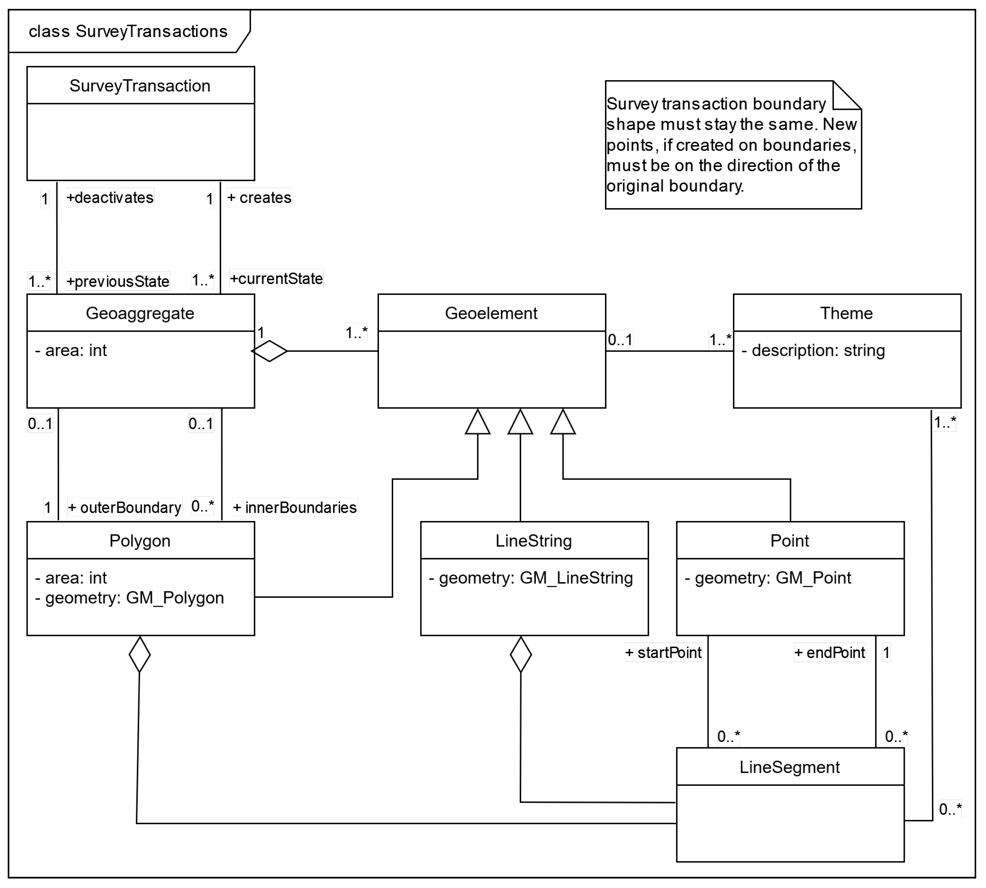
The domain model representing the LAS survey transactions is represented in
Figure 3. An important abstraction introduced in this class diagram is the class Geoaggregate. It represents a collection of geoelements that describe the geometry of a parcel. It typically contains polygons, line strings, and individual points depicting parcel features. Polygons represent areas, line strings represent linear features such as paths or retaining walls, while points represent features such as posts, wells, or other features with dimensions not significant on a given map scale.
The class Theme represents any thematic context which a geoelement can be associated with. In the case of polygons, it can be land usage, in the case of line segments it can be a type of fence, while in the case of points, it can be the purpose of a given point feature, such as a post, well, or traffic light, for example.
The class LATransaction creates one or more geoaggregate as a current state and deactivates one or more geoaggregate that represents the previous state of the same territory. Similarly, as rights in the legal transaction domain model, every geoaggregate must contain information about which transaction it has been created by, and which one it has been deactivated by, if any.
A more detailed description of the domain model representing cadastral map data abstractions and their relationships with cadastral legal concepts is available in [
26].
3.2.2. Constraints in Survey Transactions
The survey transaction area is covered by geoaggregates created by transaction execution. The topological relationships of these geoaggregates must be correct, so there is no overlapping of geoaggregates or the existence of areas that are not covered by a geoaggregate. This condition will also guarantee that the area of the current state is equal to the area of the previous state. Topological relationships of geoaggregate polygons representing parts of a parcel should also be correct in the same way.
To ensure that the coverage of a survey transaction stays the same, transaction boundaries must cover the same path, not necessarily with the same number of vertices. An example of simple parcel division depicting this rule is given in
Figure 4.
A simple survey transaction that divides a parcel labeled 100, will be considered as an example. Neighboring parcels labeled 99 and 101 are not included in the transactions’ previous state. Typically for some cadastral systems, newly created parcels will inherit the original parcels’ number and obtain subsequent parcel sub-numbers. According to this rule, newly created parcels will be labeled 100/1 and 100/2. There are also cadastral systems that label newly created parcels with new numbers.
In this example, it can be seen that the geometry of neighboring parcels labeled 99 and 101 is affected by this transaction, even though they were not part of the previous state. After the execution of the transaction, both neighboring parcels now have five instead of the original four vertices. To ensure the shape of affected neighboring parcels is unchanged, every new vertex must be collinear with the endpoints of the divided line.
Another validation rule is that newly created parcels must have a unique label (number and sub-number combination) in the cadastral municipality. These numbers can be generated by software or defined by the user executing the transaction. In the latter case, the software has to check if a user duplicated the parcel label for a given cadastral municipality.
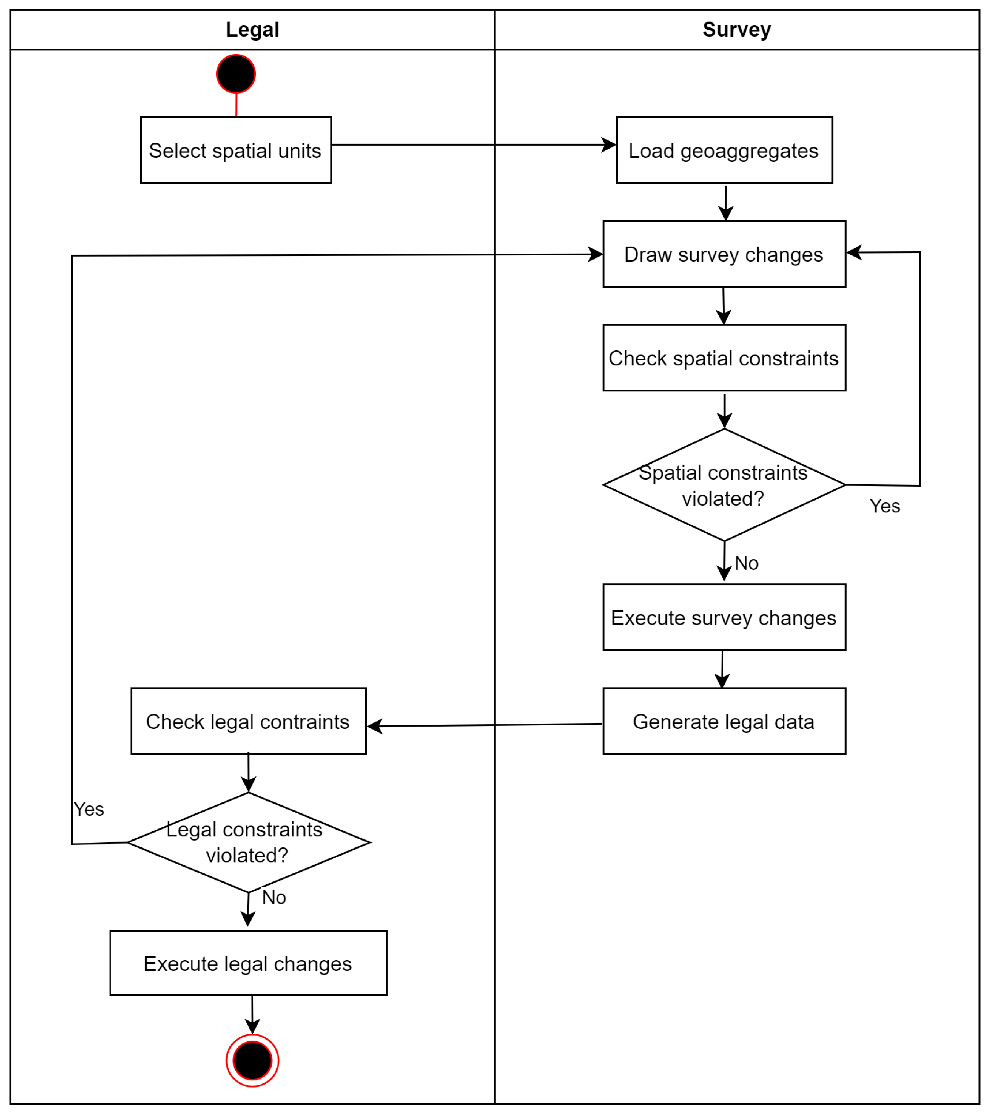
3.3. Composite Transactions
As previously mentioned, changes that include both legal and survey data are referred to as composite transactions. The activity diagram showing the full execution flow of the simple parcel division is presented in
Figure 5.
From the activity diagram, it can be seen that survey data changes are inputted for legal data changes. Examples of survey data used for legal data generation include parcel labels, parcels and part of parcel areas, and land usage data.
While legal data typically record areas as whole-number values, survey data polygon areas calculated according to their vertex coordinates have decimal number values. Rounding decimal polygon area values can result in a difference between the total area of the previous state and the current state in the legal dataset. Presuming that the polygon representing parcel 100 from the
Figure 4 example has an area of 200.6 square meters, parcel 100 in the legal register will have an area rounded to 201 square meters. If we say that polygons representing parcels 100/1 and 100/2 have areas 120.4 and 80.2, respectively, their areas will be rounded to 120 and 80, so, after the transaction, the current state will be one square meter less than the previous state. This problem in the legal changes procedure resolves by leveling areas before and after the transaction. Generally, there can be many parcels affected by the transaction and the area difference for the leveling will be distributed proportionally to the parcel area affected by the transaction.
A comprehensive analysis of a property subdivision use case in Sweden, with the structural analysis conducted using LADM, is described and discussed in [
56].
Legal and Survey Data Consistency
Legal and survey data consistency is crucial for LAS data correctness. Some of the constraints that should be checked are:
Parcels in LASs are identified by their labels. Typically the label consists of the parcel number or sub-number, if the parcel originates from the previous parcel division. If the legal data transactions are not executed in synchronization with survey data transactions, the LAS will enter an inconsistent state. On the legal data side, there will be parcels that exist without their corresponding geoaggregate in the survey data. Moreover, geoaggregates will appear in the survey data that do not have corresponding parcels in the legal data.
Area compatibility means that the area of the parcel recorded in the legal dataset has to be equal to the area of the corresponding geoaggregate in the survey dataset. The same stands for parts of parcels and their corresponding polygons.
If LAS has a thematic data component, then the mapping that defines which thematic features from the survey dataset correspond to the legal dataset attributes must be defined. For example, various topographic symbols on cadastral maps represent corresponding land usage that is recorded in the legal dataset.
5. Proposed Solution
The proper way to design and implement a DSL is to create abstract syntax, concrete syntax, and semantics. Abstract syntax represents a basic skeleton of a language and can be used as a starting point for defining concrete syntax and semantics, but a concrete order of steps could be argued [
70]. In this case, a first-language grammar was created, and, based on that grammar, a meta-model was built. Meta-modeling represents a popular method for defining the abstract syntax of a language. The grammar of DSL for LAS transactions was created using textX. TextX (The full documentation on textX could be found on the following link (
http://textx.github.io/textX/3.0/), accessed 28 June 2022) is a meta-language and a tool that was created to facilitate the building of DSLs. It was built on top of the Arpeggio parser, and it makes it possible to construct both the Arpeggio parser and meta-model from a single grammar description at run-time [
71].
The TextX grammar description represents a set of rules. Rules could be one of common rules (or simply rules), abstract rules, or match rules. The common rules contain at least one assignment, the abstract rules have no assignments reference at least one abstract or common rule, and the match rules are the basic building blocks for more complex expressions—they will consume input on success. Each rule defines one concept from a meta-model and at the same time a syntax for that concept. A rule begins with a name and column symbol and ends with a semi-column.
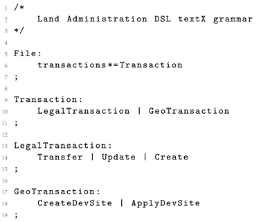
In
Listing 1, the abstract rules for File, Transaction, LegalTransaction, and GeoTransaction are declared. An example of a rule declaration can be seen in lines 5 through 7. In line 5, the abstract rule name is declared with the word File followed by a column. In line 6, it is stated that in File there could be zero or more transactions of type Transaction, indicated by the asterisk symbol. In line 7, there is a semi-column symbolizing the end of the specific rule. In a similar way, the abstract rule Transaction is declared, stating that the transaction is either a LegalTransaction or GeoTransaction. Abstract rule LegalTransaction declares that a legal transaction is one of Transfer, Update, or Create, while abstract rule GeoTransaction states that survey transaction is either CreateDevSite or ApplyDevSite.
Listing 1. DSL textX grammar—File, Transaction, LegalTransaction, and GeoTransaction.
Listing 1. DSL textX grammar—File, Transaction, LegalTransaction, and GeoTransaction.
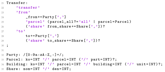
In
Listing 2, the Transfer, Party, Parcel, Building, and Share rules are presented. In the Transfer rule, it is declared that transfers should have one or more parties selling one or more parcels with specific shares to one or more parties in a specific share. A Share is an optional rule, since, in case no share is specified, it is considered that full ownership is being transferred. The Party rule is defined with regular expressions to make it possible for a party to be represented with strings and/or numbers. Similarly, the declarations of Parcel, Building, and Share define common formats for representing parcel, building, and share in LASs. For example, in the case of the parcel 34/101/2, it would mean that, in the cadastral municipality with id 34, there is a parcel with id 101, with a parcel part with id 2. In the case of the building, 37/104/3/10, 37 represents the cadastral municipality with the same id, 104 represents the id of a parcel in that cadastral municipality, 3 represents the building id, and 10 the unit id. For a share, a fraction is used to represent a share of the ownership where 1/2 would mean that the party is participating in the transfer with a 50% share of the ownership.
Listing 2. DSL textX grammar—Transfer, Party, Parcel, Building, and Share.
Listing 2. DSL textX grammar—Transfer, Party, Parcel, Building, and Share.
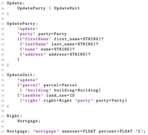
Listing 3, presents abstract rules for Update and Right, together with rules for UpdateParty, UpdateUnit, and Mortgage. The Update abstract rule states that the update falls under either the UpdateParty rule or the UpdateUnit rule. Rule UpdateParty declares that the properties (i.e., first name, last name, name, and address) of a party could be updated, while rule UpdateUnit declares that the property’s land use and right could be updated for parcel or building. The abstract rule Right states that it is related to mortgage, and the Mortgage rule defines the properties of amount and interest rate of a mortgage.
Listing 3. DSL textX grammar—Update, UpdateParty and UpdateUnit.
Listing 3. DSL textX grammar—Update, UpdateParty and UpdateUnit.
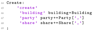
In
Listing 4, the Create rule is specified for adding/creating a new building. For adding a new building, a building id is necessary, as well as the specification of one or more parties that posses a specific share of the ownership.
Listing 4. DSL textX grammar—Create.
Listing 4. DSL textX grammar—Create.
In
Listing 5, the rules for CreateDevSite, ApplyDevSite, DevSiteID, GeoAggregateID, and Comment are declared. CreateDevSite is a rule for performing survey transactions. It states that one or more geoaggregate should be selected, and a development site created. Since this is related to the manipulation of the spatial objects, it is not feasible to create a textual DSL for these actions. Instead, a GUI application should be launched, and selected geoaggregates loaded. Upon making the changes in the spatial data using this GUI, the ApplyDevSite rule is used to initiate the process of storing the changes in the legal register. The remaining rules, DevSiteID, GeoaggregateID, and Comment, declare how the development site and geoaggregate ids should be formatted, as well as how comments could be added to the proposed DSL.
Listing 5. DSL textX grammar—CreateDevSite, ApplyDevSite, DevSiteID, and GeoAggregateID.
Listing 5. DSL textX grammar—CreateDevSite, ApplyDevSite, DevSiteID, and GeoAggregateID.
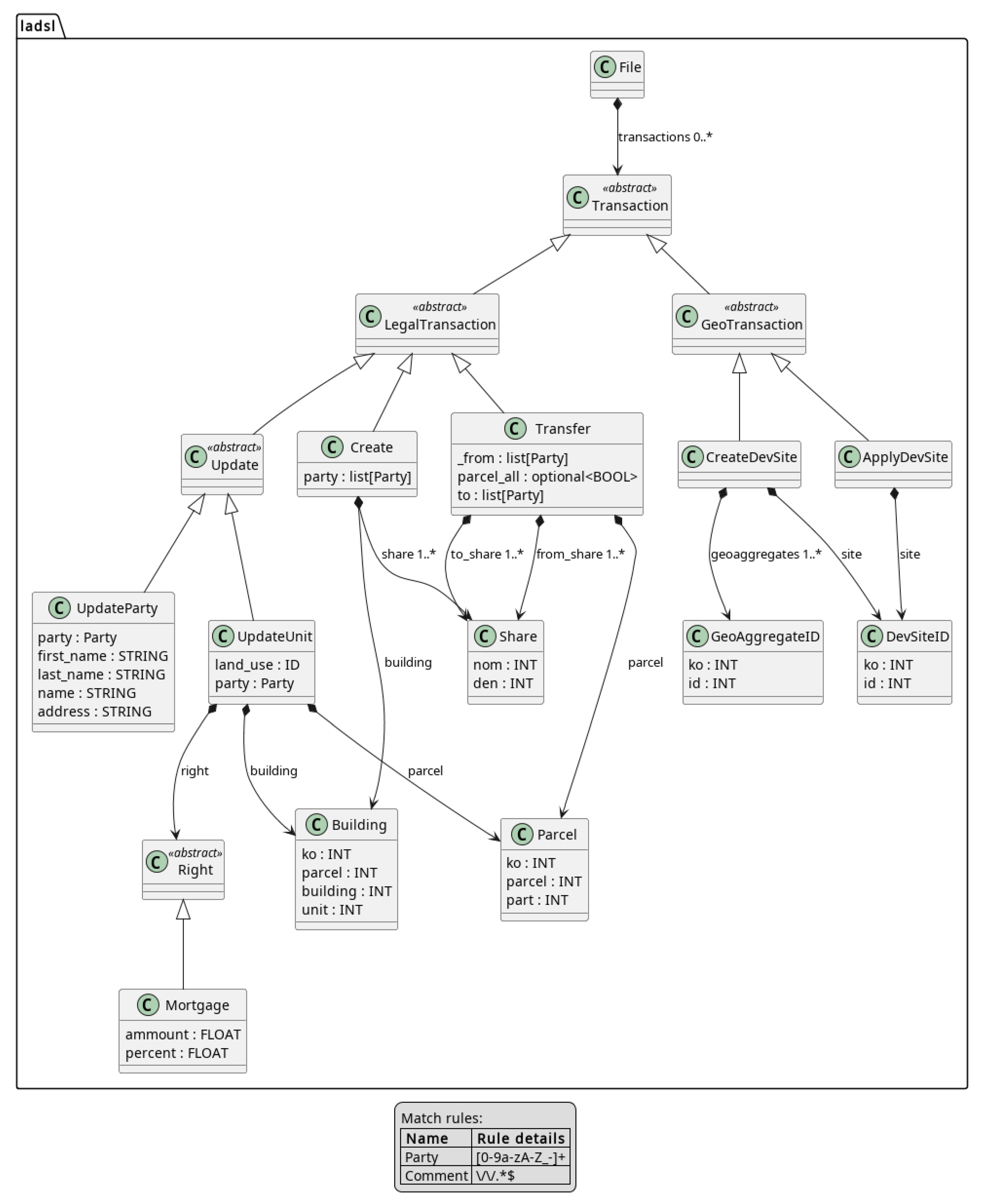
Based on the described textX grammar, a meta-model for DSL is created; it is presented in
Figure 7.
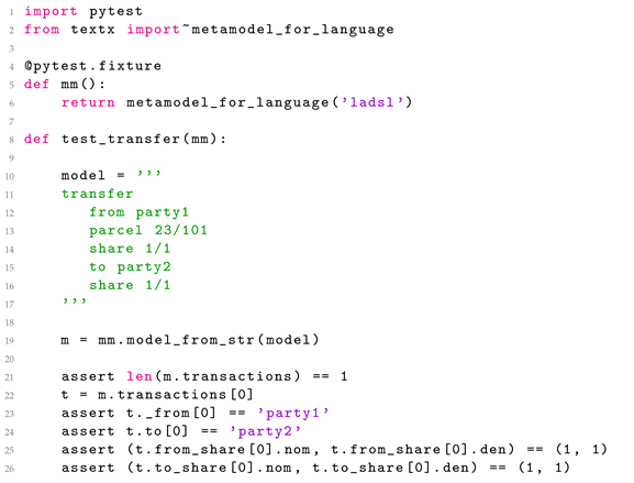
To demonstrate the usage of the proposed DSL, several use cases were created. For each use case, a test was written. In
Listing 6, a DSL for simple transfer where Party1 is selling parcel 23/101 in share 1/1 to Party2 is shown in lines 11 through 16.
Listing 6. DSL test—Simple transfer.
Listing 6. DSL test—Simple transfer.
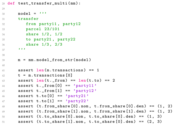
In
Listing 7, party11 and party12 are selling parcel 23/101 with the share in the ownership of 1/2 and 1/2, to party21 and party22 in the shares 1/3 and 2/3, respectively. The DSL for this transfer is written in lines 31 through 36.
Listing 7. DSL test—Transfer involving multiple parties and different share of ownership.
Listing 7. DSL test—Transfer involving multiple parties and different share of ownership.
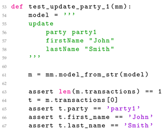
In
Listing 8, the first and last names of the party1 are changed. The DSL for this update is written in lines 50 through 53.
Listing 8. DSL test—Updating party.
Listing 8. DSL test—Updating party.
In
Listing 9, the company name of party1 is changed. The DSL for this update is written in lines 66 through 68.
Listing 9. DSL test—Updating party representing a company.
Listing 9. DSL test—Updating party representing a company.
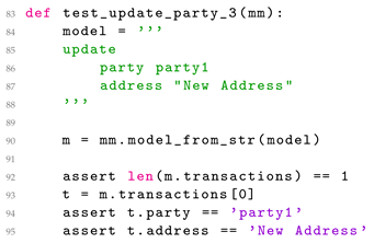
In
Listing 10, party1’s address is changed. The DSL for this update is written in lines 80 through 82.
Listing 10. DSL test—Updating party address.
Listing 10. DSL test—Updating party address.
In
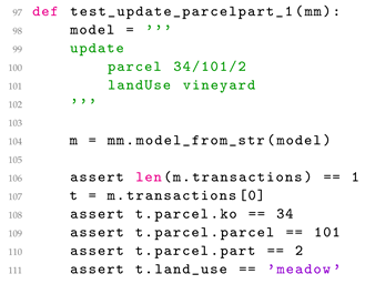
Listing 11, land use for part of parcel 34/101/2 is changed. The DSL for this update is written in lines 94 through 96.
Listing 11. DSL test—Updating parcel land use.
Listing 11. DSL test—Updating parcel land use.
In
Listing 12, the mortgage is set at 45,000.00 with a 7% interest rate, on building 34/101/2 on behalf of party1. The DSL for this update is written in lines 110 through 114.
Listing 12. DSL test—Updating rights.
Listing 12. DSL test—Updating rights.
In
Listing 13, a new building is added/created, with id 34/101/2, and party1 and party2 are set as the owners in 1/3 and 2/3 shares. The DSL for this creation is written in lines 129 through 132.
Listing 13. DSL test—Creating building.
Listing 13. DSL test—Creating building.
In
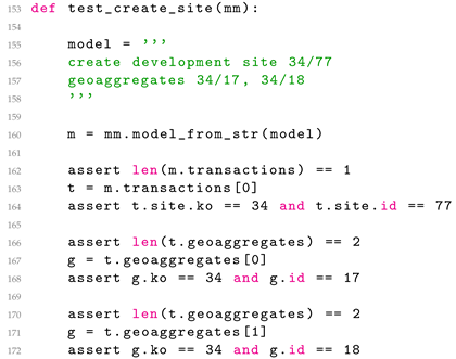
Listing 14, a new development with id 34/77 is being created from geoaggregates 34/17 and 34/18. The DSL for this creation is written in lines 149 through 150.
Listing 14. DSL test—Creating development site.
Listing 14. DSL test—Creating development site.
In
Listing 15, the finished development site with id 34/77 is being applied to the legal register. The DSL for this apply statement is written in line 170.
Listing 15. DSL test—Applying development site.
Listing 15. DSL test—Applying development site.
6. Conclusions
In this paper, LAS transactions have been analyzed and discussed. Common challenges regarding LAS transactions’ execution and LAS data integrity enforcement have been addressed. A use case in which a survey data update initialises a change in legal data is also presented. Automation of this part of the process would improve LAS transaction execution.
As previously mentioned, to the best knowledge of the authors, there was no research conducted on developing DSL in the field of LASs or, more specifically, for managing LAS transactions. Several papers related to DSLs in domains of modeling processes in landscapes and land use do not have either defined meta-models, grammar, or test cases.
A DSL for LAS transactions would introduce most of the benefits that the application of DSL brings, such as a new level of abstraction, domain expert usage, statement validation, statement interpretation on various platforms, and using different GPLs. A proposal for a system architecture that would enable the writing, parsing, and execution of DSL for LAS transactions statements is also presented in the paper. The grammar of the language is presented together with meta-model visualisation. Examples of statements and tests are also given for representative types of statements.
However, the proposed DSL for LAS transactions has some limitations. The biggest one is that textual DSL is not suitable for geometry data manipulation. To effectively prepare data for survey transactions, an appropriate GUI tool should be provided. The development of domain-specific tool for survey data manipulation is a significant area for further research and development. This tool should guide the end user through the process of survey data preparation for transaction execution, so the resulting data are valid, correct, and accurate.
Another further research direction is the development of a user-friendly integrated development environment (IDE) that would assist domain experts in writing DSL for LAS transactions statements. Typical IDE tools, such as syntax highlighting, code completion, or code templates, would make users more efficient and code less error prone.
Aspects of DSL for LAS transactions that should be further analyzed are possible alternative options for statement storage. In the case of the distributed ledger, private or hybrid blockchain should be considered together with the security aspects and context of the corresponding legal framework.


