GIS Based Procedural Modeling in 3D Urban Design
Abstract
1. Introduction
2. Related Work
- (1)
- Layout modeling refers to the procedural generation of parcels inside city blocks. Several pieces of research aimed to synthesize new urban layouts by creating and/or joining fragments of pre-existing examples [22,23,24,25,26]. For instance, Aliaga et al. [22] performed both a structure-based synthesis and an image-based synthesis to create urban layouts using example fragments from several real-world cities. Vanegas et al. [25] presented skeleton-based subdivisions and oriented bounding box subdivisions to generate spatial configurations of parcels with high similarity to those observed in real-world cities. In contrast, our method generates urban layouts through a set of procedural rules rather than reproduces or starts with existing urban layouts.
- (2)
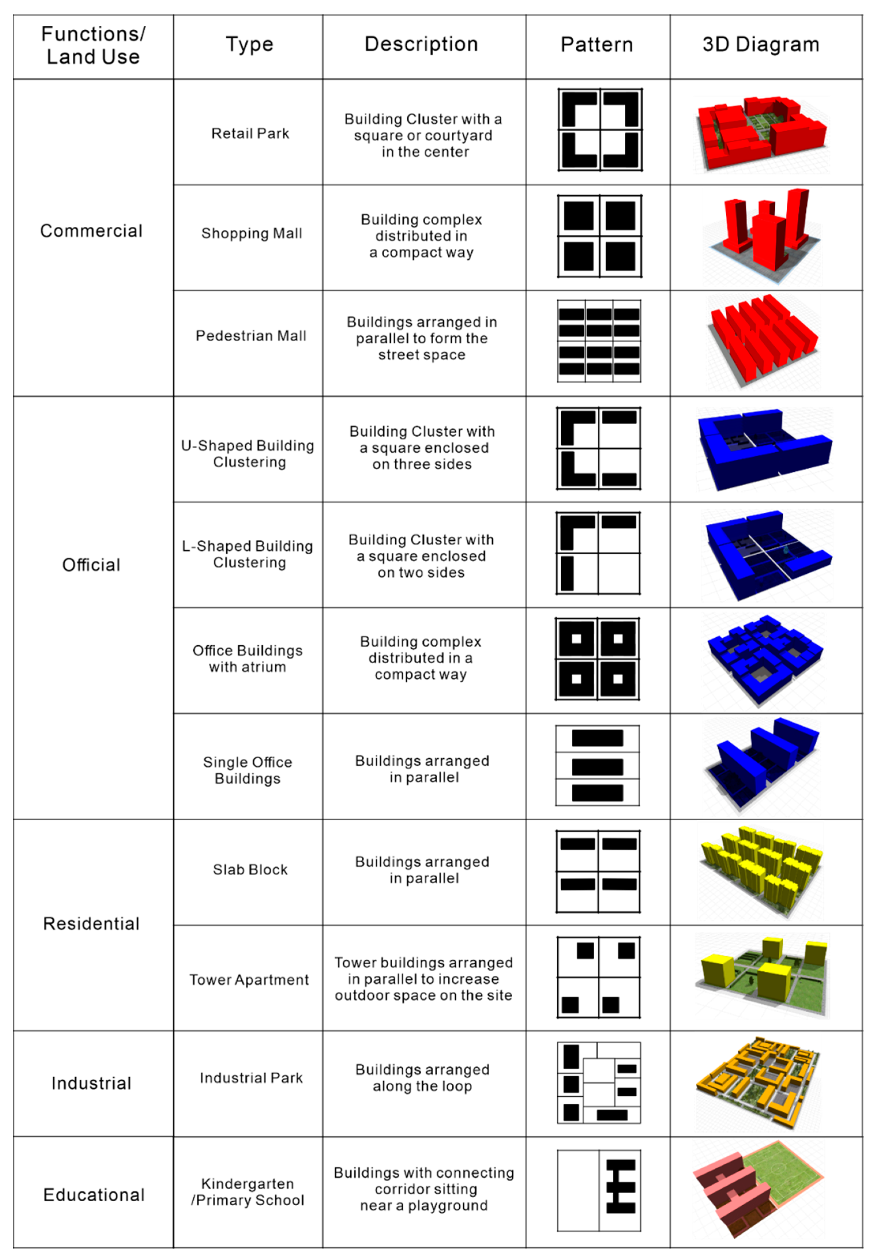
- Building modeling addressed the problem of generating 3D building models. Most of the previous works focused on generating a compact, efficient, and reusable procedural representation to construct a new 3D architectural model that resembles the original [27,28,29,30,31]. Aliaga et al. [27] proposed a method to construct a grammar from photographs, enabling the rapid sketching of novel architectural structures in the original style. Demir et al. [14] converted an architectural model into a split tree and synthesized new geometric models with the extracted split tree. Compared to previous work, the 3D architectural model generated from our workflow is land-use-based. That is to say, instead of reproducing a specific architectural style, we try to restore the general building types of the different urban functional zone.
- (3)
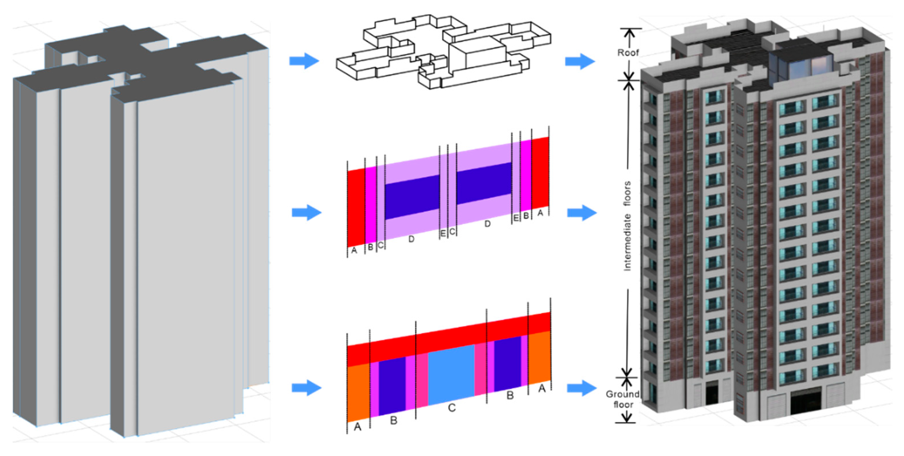
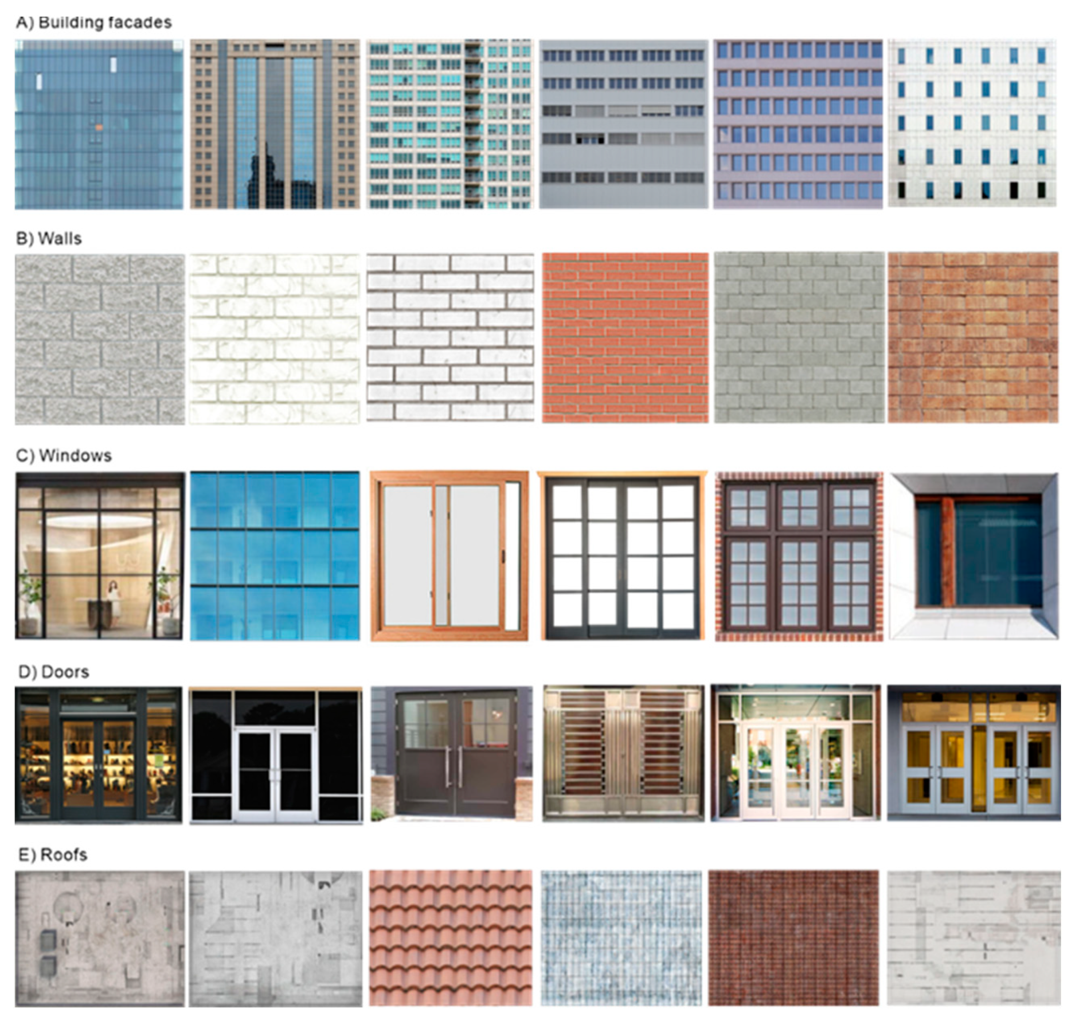
- Facade modeling applied a segmentation algorithm for facade reconstruction from image data or LIDAR scanning results [32,33,34,35,36,37]. Van Gool et al. [36] discussed different facade reconstruction algorithms and used one rule set for the reconstruction of different kinds of buildings. Wan and Sharf [37] presented a method for finding the best segmentation of facades through maximum likelihood formulation and then reconstructing building facades from LIDAR scans using a grammar-based segmentation algorithm. In this work, we seek to explore the procedural representation method of facade modeling and texture mapping. The main difference from previous work is that we try to implement a land-use-based texture mapping.
- (4)
- Urban modeling explored an efficient way of urban scale modeling and rendering [38,39,40,41,42]. Kuang [41] implemented highly memory-efficient modeling and rendering of urban buildings by proposing a hierarchical grid-based modeling method and a data structure called Non-Uniform Texture. Marvie et al. [42] introduced GPU Shape Grammars for real-time generation, tuning, and rendering of procedural models. In this work, we applied the CGA grammars for large-scale procedural modeling with the advantage of avoiding explicit storage of expanded geometry and delaying the generation of buildings until the rendering stage.
3. Methods
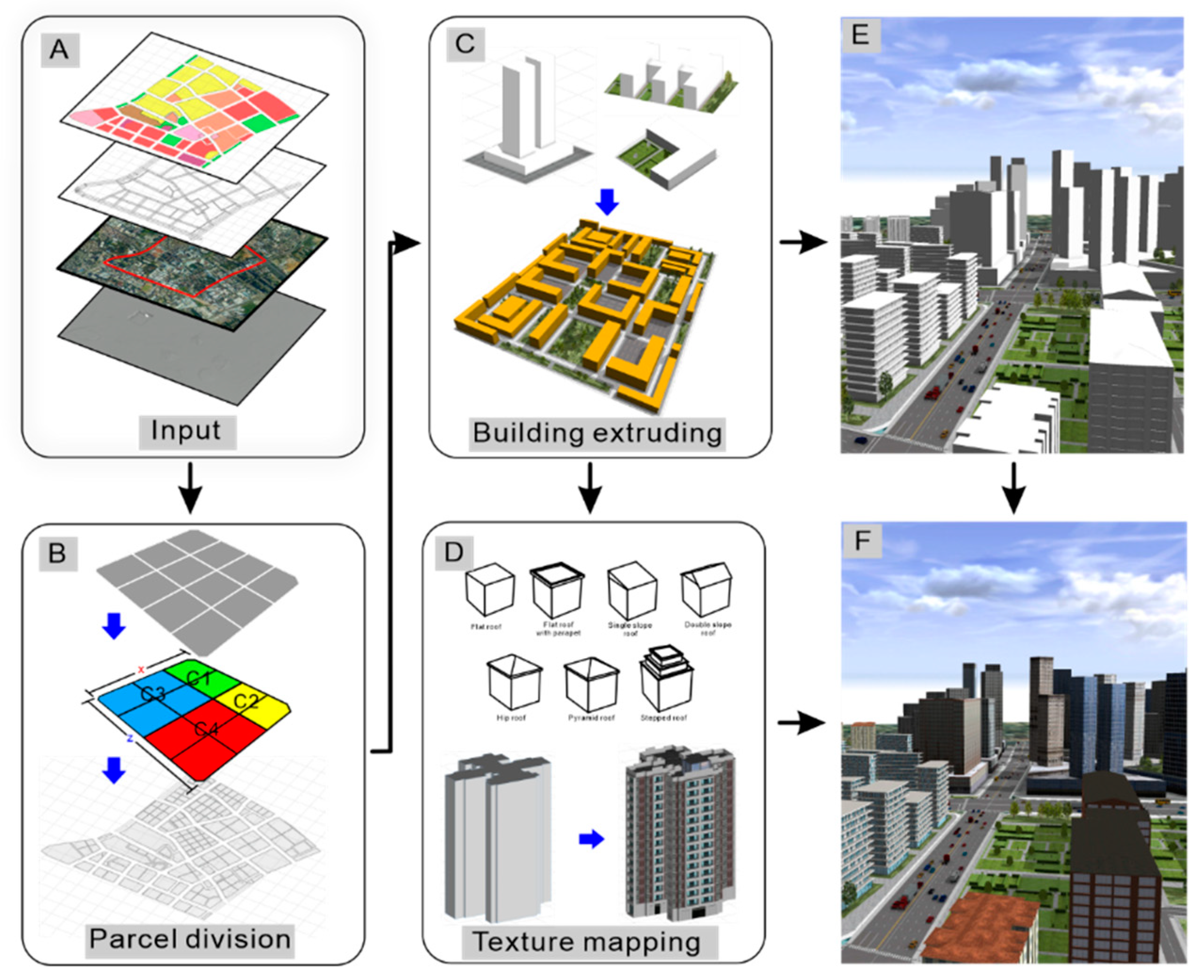
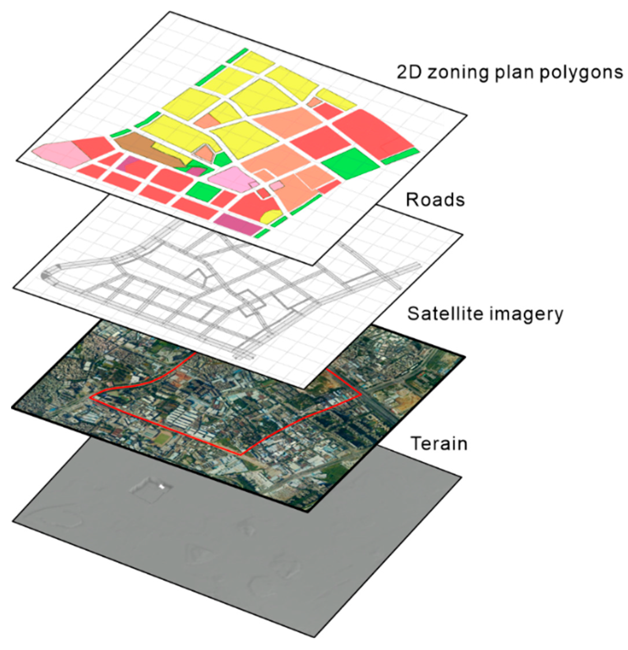
3.1. Data Preparation
3.2. Grammar Parsing and Derivation
3.3. Urban Procedural Modeling
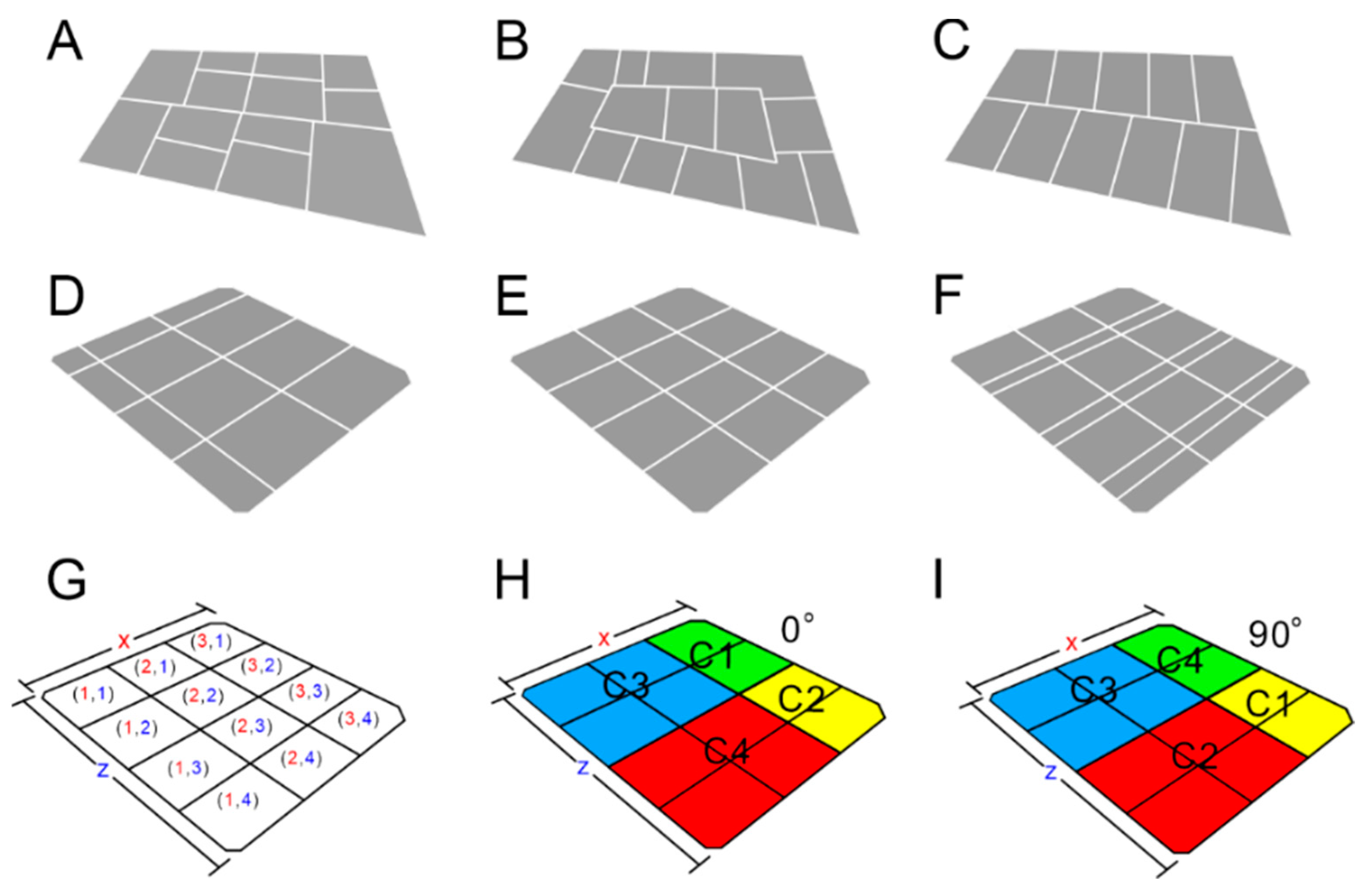
3.3.1. Parcel Subdivision and Clustering
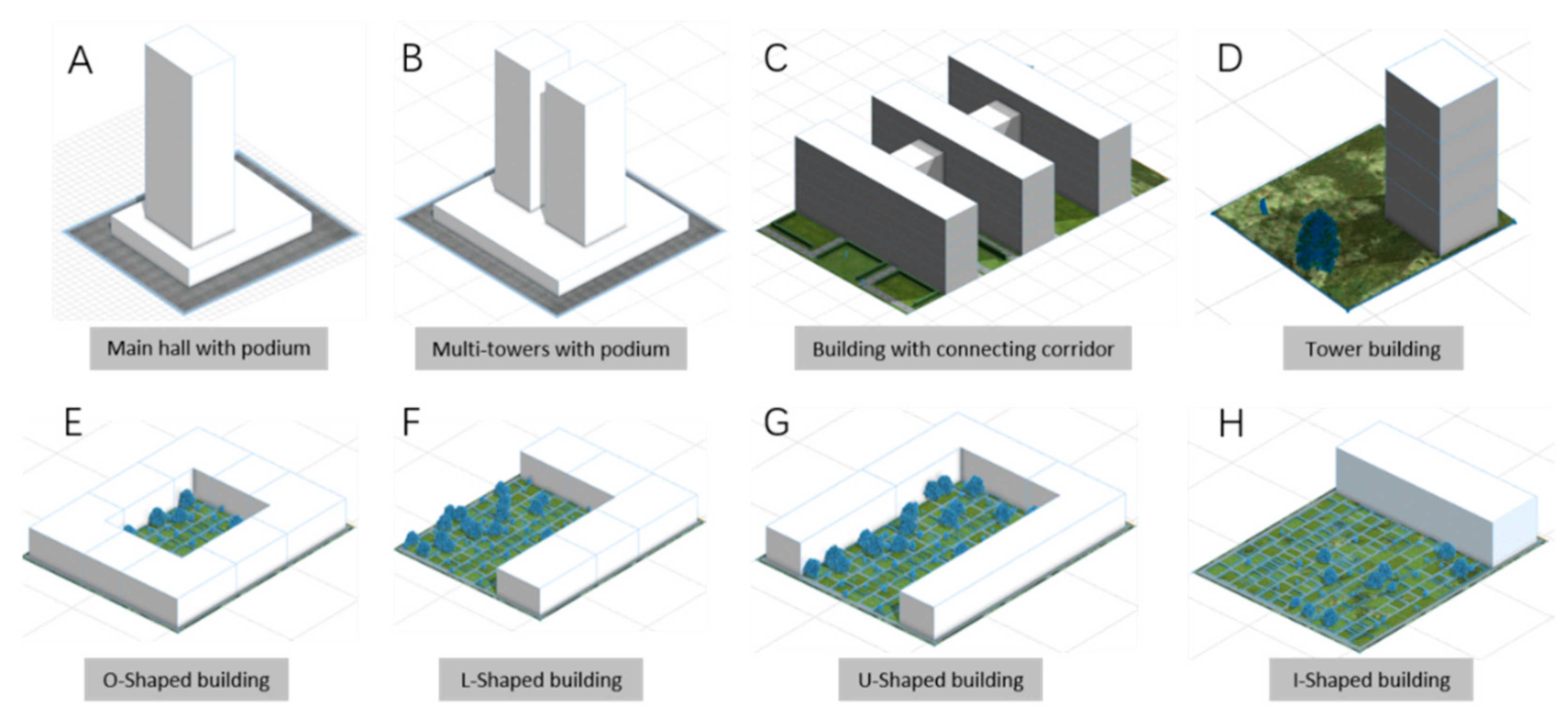
3.3.2. Building Extrusion
3.4. Texture Mapping
4. Case Study
4.1. Case 1: Urban Renewal Project of H-Village
4.1.1. Background
4.1.2. Restrictions and Requirements
4.1.3. Multiple Proposals Generation
4.1.4. Alternative Facade Proposals
4.2. Case 2: Urban Design Strategy of Air–Rail Integration Zone
4.2.1. Background
4.2.2. Restrictions and Requirements
4.2.3. Multiple Proposals Generation
5. Discussion
- (1)
- PM is the most efficient modeling method of urban design. With the well-developed CGA algorithm, designers can generate several square kilometers of urban design models in a matter of seconds, which allows urban designers to generate design models nearly real-time. Although the models produced by the PM method merely achieve similar degrees of accuracy to those produced by the BIM or GM method, the urban designer can easily use this method to complete the preliminary evaluation of different schemes in the early stage of urban design.
- (2)
- PM is capable of creating flexible geometries which can accommodate various boundary conditions. Relying on this ability, an agile urban design working process is applied, with the goal of allowing designers to take advantage of a high level of automation while still maintaining a high degree of control over the output. There are two working models: “generation” and “modification in the PM-based urban design process. A designer can easily switch between the two working modes. The generation model provides a fully automatic workflow that allows urban designers to generate a large variety of urban building models with the constraints of a detailed plan. The modification model gives urban designers options to modify selected model data according to different urban design concepts and needs to handle information that is not encoded into the automated processes.
6. Conclusions
Author Contributions
Funding
Data Availability Statement
Conflicts of Interest
References
- Singh, V.; Gu, N. Towards an integrated generative design framework. Des. Stud. 2012, 33, 185–207. [Google Scholar] [CrossRef]
- Batty, M.; Dodge, M.; Jiang, B.; Smith, A. GIS and Urban Design. In Geographical Information and Planning: European Perspectives; Geertman, S., Openshaw, S., Stillwell, J., Eds.; Springer: Berlin/Heidelberg, Germany, 1998; 32p, in press. [Google Scholar]
- Walmsley, K.; Villaggi, L. Generative Urban Design: A Collaboration between Autodesk Research and Van Wijnen. 2019. Available online: https://www.autodesk.com/autodesk-university/article/Generative-Urban-Design-Collaboration-Between-Autodesk-Research-and-Van-Wijnen-2019 (accessed on 1 May 2022).
- Chowdhury, S. Design Thinking for Computer-Aided Co-Design in Architecture and Urban Design. In Augmented Reality and Its Application; Cvetković, D., Ed.; IntechOpen: London, UK, 2021. [Google Scholar] [CrossRef]
- Krish, S. A practical generative design method. Comput.-Aided Des. 2011, 43, 88–100. [Google Scholar] [CrossRef]
- Aliaga, D.G. 3D design and modeling of smart cities from a computer graphics perspective. Int. Sch. Res. Not. 2012, 2012, 728913. [Google Scholar] [CrossRef]
- Parish, Y.I.H.; Müller, P. Procedural Modeling of Cities. In Proceedings of the 28th Annual Conference on Computer Graphics and Interactive Techniques, Los Angeles, CA, USA; 2001; pp. 301–308. [Google Scholar] [CrossRef]
- Batty, M. Cities and Complexity: Understanding Cities with Cellular Automata, Agent—Based Models, and Fractals; The MIT Press: Cambridge, MA, USA, 2007. [Google Scholar]
- Wu, Z.; Gan, W.; Zang, W.; Ma, C.; Zhou, J.; He, Z.; Zhou, X. Concept and Development of the City in Telligent Model (CIM). City Plan. Rev. 2021, 45, 113–118. [Google Scholar]
- Yang, J.; Shao, D.; Fu, X.; Min, H. Progressive optimization of urban design based on the digital map of physical environment: Process exploration. City Plan. Rev. 2022, 64–80. [Google Scholar]
- Yang, J.; Liu, Z.; Wang, Q.; Yao, L.; Li, T.; Hu, M.; Shi, Y.; Lu, J.; Zhang, J.; Cheng, Y.; et al. Research and Application of Key Technologies of Urban Design Digital Platform. Constr. Sci. Technol. 2021, 117–120. [Google Scholar] [CrossRef]
- Badwi, I.M.; Ellaithy, H.M.; Youssef, H.E. 3D-GIS Parametric modelling for virtual urban simulation using CityEngine. Ann. GIS 2022, 28, 325–341. [Google Scholar] [CrossRef]
- Khayyal, H.K.; Zeidan, Z.M.; Beshr, A.A.A. Creation and spatial analysis of 3D city modeling based on GIS data. Civ. Eng. J. 2022, 8, 2676–6957. [Google Scholar] [CrossRef]
- Pepe, M.; Costantino, D.; Alfio, V.S.; Vozza, G.; Cartellino, E. A novel method based on deep learning, GIS and geomatics software for building a 3D city model from VHR satellite stereo imagery. ISPRS Int. J. Geo-Inf. 2021, 10, 697. [Google Scholar] [CrossRef]
- Demir, I.; Aliaga, D.G.; Benes, B. Proceduralization for editing 3D architectural models. In Proceedings of the Fourth International Conference on 3D Vision, Stanford, CA, USA, 25–28 October 2016; pp. 194–202. [Google Scholar] [CrossRef]
- Marvie, J.-E.; Perret, J.; Bouatouch, K. The FL-system: A functional Lsystem for procedural geometric modeling. Vis. Comput. 2005, 21, 329–339. [Google Scholar] [CrossRef]
- Wonka, P.; Wimmer, M.; Sillion, F.; Ribarsky, W. Instant Architecture. ACM Trans. Graph. 2003, 22, 669–677. [Google Scholar] [CrossRef]
- Lindenmayer, A. Mathematical models for cellular interactions in development II. Simple and branching filaments with two-sided inputs. J. Theor. Biol. 1968, 18, 300–315. [Google Scholar] [CrossRef]
- Stiny, G.; Gips, J. Shape Grammars and the Generative Specification of Painting and Sculpture. In Information Processing 71; Freiman, C.V., Ed.; North Holland: Amsterdam, The Netherlands, 1972; pp. 1460–1465. [Google Scholar]
- Stiny, G.; Mitchell, W.J. The Palladian grammar. Environ. Plan. B Plan. Des. 1978, 5, 5–18. [Google Scholar] [CrossRef]
- Müller, P.; Wonka, P.; Haegler, S.; Ulmer, A.; Gool, L.V. Procedural modeling of buildings. ACM Trans. Graph. 2006, 25, 614–623. [Google Scholar] [CrossRef]
- Aliaga, D.G.; Beneš, B.; Vanegas, C.A.; Andrysco, N. Interactive reconfiguration of urban layouts. IEEE Comput. Graph. Appl. 2008, 28, 38–47. [Google Scholar] [CrossRef]
- Chen, G.; Esch, G.; Wonka, P.; Müller, P.; Zhang, E. Interactive procedural street modeling. ACM TOG 2008, 27, 103. [Google Scholar] [CrossRef]
- Nishida, G.; Garcia-Dorado, I.; Aliaga, D.G. Example-driven procedural urban roads. Comput. Graph. Forum 2015, 35, 1–13. [Google Scholar] [CrossRef]
- Vanegas, C.A.; Kelly, T.; Weber, B.; Halatsch, J.; Aliaga, D.G.; Müller, P. Procedural generation of parcels in urban modeling. Comput. Graph. Forum 2012, 31, 681–690. [Google Scholar] [CrossRef]
- Yang, Y.; Wang, J.; Vouga, E.; Wonka, P. Urban pattern: Layout design by hierarchical domain splitting. ACM TOG 2013, 32, 1–12. [Google Scholar] [CrossRef]
- Aliaga, D.G.; Rosen, P.A.; Bekins, D.R. Style grammars for interactive visualization of architecture. IEEE Tran Actions Vis. Comput. Graph. 2007, 13, 786–797. [Google Scholar] [CrossRef]
- Bekins, D.; Aliaga, D.G. Build-by-Number: Rearranging the real world to visualize novel architectural spaces. In Proceedings of the IEEE Visualization, Minneapolis, MN, USA, 23–28 October 2005; pp. 143–150. [Google Scholar]
- Hohmann, B.; Havemann, S.; Krispel, U.; Fellner, D. A GML shape grammar for semantically enriched 3D building models. Comput. Graph. 2010, 34, 322–334. [Google Scholar] [CrossRef]
- Nishida, G.; Garcia-Dorado, I.; Aliaga, D.G.; Benes, B.; Bousseau, A. Interactive sketching of urban procedural models. ACM Trans. Graph. 2016, 35, 130. [Google Scholar] [CrossRef]
- Vanegas, C.A.; Allaga, D.G.; Benes, B. Building reconstruction using manhattan-world grammars. In Proceedings of the 2010 IEEE Computer Society Conference on Computer Vision and Pattern Recognition, San Francisco, CA, USA, 13–18 June 2010; pp. 358–365. [Google Scholar]
- Alegre, F.; Dallaert, F. A Probabilistic Approach to the Semantic Interpretation of Building Facade. 2004. Available online: https://smartech.gatech.edu/handle/1853/4483 (accessed on 1 May 2022).
- Cohen, A.; Schwing, A.G.; Pollefeys, M. Eicient Structured Parsing of Facades Using Dynamic Programming. In Proceedings of the 2014 IEEE Conference on Computer Vision and Pattern Recognition, Columbus, OH, USA, 23–28 June 2014; pp. 3206–3213. [Google Scholar]
- Müller, P.; Zeng, G.; Wonka, P.; Gooll, V. Image-based procedural modeling of facades. ACM Trans. Graph. 2007, 26, 85. [Google Scholar] [CrossRef]
- Teboul, O.; Kokkinos, I.; Simon, L.; Koutsourakis, P.; Paragios, N. Parsing Facades with shape grammars and reinforcement learning. IEEE Trans. Pattern Anal. Mach. Intell. 2013, 35, 1744–1756. [Google Scholar] [CrossRef] [PubMed]
- Van Gool, L.; Zeng, G.; van den Borre, F.; Müller, P. Towards mass-produced building models. Int. Arch. Photogramm. Remote Sens. Spat. Inf. Sci. 2007, 36, 209–221. [Google Scholar]
- Wan, G.; Sharf, A. Grammar-based 3D facade segmentation and reconstruction. Comput. Graph. 2012, 36, 216–223. [Google Scholar] [CrossRef]
- Demir, I.; Aliaga, D.G.; Benes, B. Proceduralization of building at city scale. In Proceedings of the Second International Conference on 3D Vision, Tokyo, Japan, 8–11 December 2014; pp. 456–463. [Google Scholar] [CrossRef]
- Vanegas, C.A.; Garcia-doradoi, I.; Aliaga, D.G.; Beneš, B.; Waddell, P. Inverse design of urban procedural models. ACM Trans. Graph. 2012, 31, 168. [Google Scholar] [CrossRef]
- Weber, B.; Müller, P.; Wonka, P.; Gross, M. Interactive geometric simulation of 4D cities. Comput. Graph. Forum 2009, 28, 481–492. [Google Scholar] [CrossRef]
- Kuang, Z.; Chan, B.; Yu, Y.; Wang, W. A compact random-access representation for urban modeling and rendering. ACM Trans. Graph. 2013, 32, 1–12. [Google Scholar] [CrossRef]
- Marvie, J.; Buron, C.; Gautron, P.; Hirtzlin, P.; Sourimant, G. GPU Shape Grammrs. Comput. Graph. Forum 2012, 31, 2087–2095. [Google Scholar] [CrossRef]
- Živković, J. Urban Form and Function; Climate Action: London, UK, 2019; ISBN 978-3-319-71063-1. [Google Scholar]
- Früh, C.; Zakhor, A. An automated method for large-scale, ground-based city model acquisition. Int. J. Comput. Vision 2004, 60, 5–24. [Google Scholar] [CrossRef]
- Korah, T.; Rasmussen, C. Analysis of building textures for reconstructing partially occluded facades. In Computer Vision—ECCV 2008, Proceedings of the 10th European Conference on Computer Vision, Marseille, France, 12–18 October 2008; Springer: Berlin/Heidelberg, Germany, 2008. Part I. [Google Scholar]
- Tan, Y.K.A.; Kwoh, L.K.; Ong, S.H. Large scale texture mapping of building facades. Int. Arch. Photogramm. Remote Sens. Spat. Inf. Sci. 2008, XXXVII Pt B5, 1–6. [Google Scholar]
- Teller, S.; Antone, M.; Bodnar, Z.; Bosse, M.; Coorg, S.; Jethwa, M.; Master, N. Calibrated, registered images of an extended urban area. Int. J. Comput. Vis. 2003, 53, 93–107. [Google Scholar] [CrossRef]




| Group | Restrictions and Requirements for the Urban Design |
|---|---|
| Rural Community | Proper ratio of the residential function Keeping the cultural context |
| Town Community | Keeping the existing community Control of height |
| Guangzhou Metro | Sparing open space for Line 14 and stations |
| Enterprises | Identity of the site/Fantasy facade Network of open space |
| Developer | Financial balance Feasibility |
| Local Government Authority | Street view Future development Satisfaction of residents |
| Elements | Restrictions and Requirements for the Urban Design |
|---|---|
| Rivers |
|
| Special Customs Supervision Zone |
|
| Air–Rail Line Development |
|
Publisher’s Note: MDPI stays neutral with regard to jurisdictional claims in published maps and institutional affiliations. |
© 2022 by the authors. Licensee MDPI, Basel, Switzerland. This article is an open access article distributed under the terms and conditions of the Creative Commons Attribution (CC BY) license (https://creativecommons.org/licenses/by/4.0/).
Share and Cite
Zhang, M.; Wu, J.; Liu, Y.; Zhang, J.; Li, G. GIS Based Procedural Modeling in 3D Urban Design. ISPRS Int. J. Geo-Inf. 2022, 11, 531. https://doi.org/10.3390/ijgi11100531
Zhang M, Wu J, Liu Y, Zhang J, Li G. GIS Based Procedural Modeling in 3D Urban Design. ISPRS International Journal of Geo-Information. 2022; 11(10):531. https://doi.org/10.3390/ijgi11100531
Chicago/Turabian StyleZhang, Ming, Jielin Wu, Yang Liu, Ji Zhang, and Guanyao Li. 2022. "GIS Based Procedural Modeling in 3D Urban Design" ISPRS International Journal of Geo-Information 11, no. 10: 531. https://doi.org/10.3390/ijgi11100531
APA StyleZhang, M., Wu, J., Liu, Y., Zhang, J., & Li, G. (2022). GIS Based Procedural Modeling in 3D Urban Design. ISPRS International Journal of Geo-Information, 11(10), 531. https://doi.org/10.3390/ijgi11100531


