Article

Placial-Discursive Topologies of Violence: Volunteered Geographic Information and the Reproduction of Violent Places in Recife, Brazil

by
Cléssio Moura de Souza
1,
Dominik Kremer
2 and
Blake Byron Walker
1,*
1
Institute for Geography, Friedrich-Alexander-Universität Erlangen-Nürnberg, 91058 Erlangen, Germany
2
Department of Digital Humanities and Social Studies, Friedrich-Alexander-Universität Erlangen-Nürnberg, 91058 Erlangen, Germany
*
Author to whom correspondence should be addressed.
ISPRS Int. J. Geo-Inf. 2022, 11(10), 500; https://doi.org/10.3390/ijgi11100500
Submission received: 29 August 2022 / Accepted: 21 September 2022 / Published: 25 September 2022

Abstract

:
Knowledge and experiences of violence transform the ways in which individuals perceive the urban landscape, construct and reproduce (un)safety, and make everyday decisions regarding mobility and the use of space. This knowledge and these experiences are placially anchored and are shaped by everyday regionalisations. In the context of interpersonal violence in Recife, Brazil, we examine the ways in which volunteered geographic information (VGI), formal and informal information exchange networks, and individual experience contribute to the reproduction of violent spaces. During interviews with civilian residents and police officers, we explore the knowledge and information flows and their spatial anchorings before and after presenting informants with a VGI-based map of firearms violence. Following coding, interviews were also analysed using a novel, semiautomated text mining algorithm to produce context-sensitive co-occurrence graphs of key arguments within participant narratives. The results indicate strong differences in the placial anchorings between police officers and civilians, and highlight key dynamics in the flows of VGI amongst residents and local news organisations, as well as through social media. These forms of placial knowledge exchange are in constant negotiation with individuals’ perceptions and experiences of the study area and reflect cognitive-discursive reproductions of everyday geographies of (un)safety.

1. Introduction and Related Work

Whether directly as victim/perpetrator/witness or indirectly through knowledge of or information about an incident, experiences of violence incite locating and placial reasoning practices through which prior knowledge and experience of affected spaces are aggregated, mediated, and reshaped. This process constitutes a placial binding of a traumatic event, which in aggregate produces violent places as a social-cognitive designation that is cartographically, contextually, and epistemologically contingent. In this multimethod empirical study, we examine these practices and the role of volunteered geographic information (VGI) in shaping them.

1.1. Geographies of Unsafety and Traditional Spatial Criminology

The study of space and violence is largely rooted in spatial criminology, a methodological tradition dating back to the Chicago School, which in a positivist scientific manner introduced external factors such as social circumstances and community environments to prior approaches focusing exclusively on individual dispositions to criminality [1] (Classical criminology itself dates back to the late Middle Ages in Europe when a call for a fair and balanced, and thus broadly accepted, justice system arose against the harsh and involuntary punishments of the mediaeval era [2]). In this context, disorganisation theory used the geographical distribution of crime and delinquency over administrative spatial units (e.g., city districts) to describe breakdowns of social ties and social control [3], leading to problematising and marginalising imaginaries of urban space, such as the broken windows theory.
In the scope of digital criminology, Brian Jefferson made a significant contribution with a critical approach to the development of digital computing and its influences on criminal justice in the past forty years [4]. Since this technology has been applied both as a research and governance tool, the war on drugs and crime intensified and consequently, directly impacted mass incarceration and the criminalization of poor communities of colour. Those aspects were also illustrated in Garland’s The Culture of Control. According to Garland [5], imprisonment in late modernity plays an essential role in the attempt to control crime. In his book, Garland highlights a tendency in contemporary societies to use prison as an instrument to contain criminality and promote a sense of safety for the population. Thus, prisons have become an effective way of segregating certain social groups and have been moving them away from the ideal of prevention and rehabilitation [5] (p. 178). On a daily basis, in different contexts, people are dealing with an apparent fear of crime and are connected to it in different ways, such as social media, TV, radio, and their perceptions of spaces. The need to “be safe” not only increases the commercialization of crime control but also has become an essential topic among politicians, who ascend in popularity by designing public policies of crime control [5]. This tendency has a direct effect by shaping the common enemy and pointing out who are the “heroes and villains” in society [6]. In addition, stereotypes are used by the media to oversimplify individuals and groups, in terms of race, religion, culture, sexual orientation, and appearance, among other factors [6].
Following a demand for more precise descriptions of crime locations, spatial research in criminology has turned towards a geospatial paradigm, in which precision mapping and high-resolution analyses of places and hotspots focus on specific addresses [7] or street segments [8]. These methodologies are underpinned by a geodeterministic understanding that a certain space can induce crime [9]. Therefore, spaces act as opportunities that generate or attract crime and can therefore be perceived by offenders as stages of opportunity. In parallel, one’s fear of becoming a victim of a violent act is spatially bound to their sense of vulnerability on-site as well [10].
Weisburd et al. [11] used opportunity theory to predict the probability of crime at specific places along four dimensions: motivation of offenders, presence of suitable targets, presence of guardianship (e.g., police), and the spatial accessibility of the site. The main purpose was crime prevention by counteracting urban design [12]. In a recent revision, Brantingham et al. [13] extended this model by differentiating between crime hotspots and crime corridors. In contrast to hotspots, corridors integrate knowledge about transportation networks and flow along streets into the model, thereby approaching a topological conceptualisation of crime and space. Importantly, they integrated individual spatial choices alongside law-making and policy into their model, thereby reflecting that places as opportunities are not pre-existing, static, or stable.

1.2. Placing (Un)safety

In its tendency towards increasingly detailed spatial predictors of crime, the current state of research in criminology does not reflect findings on the structure of everyday spatial knowledge. Although the mutual relationship between place-bound opportunities and individual action roughly reflects social theory (e.g., practice theory [14]), the knowledge exchange between local residents as a means of reproducing violent places, whilst deeply spatially contingent, is not in itself bound to maps at all. In the broader context of place research (for an overview, see [15]), geographical theory describes everyday placial knowledge as an important context marker for individual spatial decision making. As social constructs, places can enable as well as restrict possible actions and are constantly being renegotiated [16]. Despite their vague geometric delineation, places are thought to have homogeneous properties throughout their spatial extent [17,18]. Weichhart and Weixlbaumer [19] demonstrated that places exist as sociocultural concepts associated much more closely with meaning and assertions than with specific locations in the geodetic sense, and that the visuality and semantics of a site enable a degree of spatial fluidity when compared to the more stable aspects of placial meaning. Accordingly, the composition and relation of places in everyday language do not have spatial topological relations; these are built on narrative and metaphoric principles that are not necessarily based on one’s own experiences [18,20], but often the product of second-hand information [16].
Interestingly, these findings are strongly supported by empirical work from geographic information science: Winter and Freksa [21] found that place descriptions are often vague verbal descriptions without a commitment to specified locations in space. Furthermore, Richter et al. [22] observed that talking about place often involves locomotion and route descriptions attached to formal or informal toponyms. Accordingly, if place names are used, they most commonly reference aggregated concepts of neighbourhoods and street names more than precise locations or administrative units. Adding to the narrative and metaphoric use of place names, everyday reasoning makes use of continuous shifts of scale by zooming in and zooming out as needed [23]. As a result, one may expect that volunteered geographical information of violence and unsafety is fundamentally more concerned with narrative knowledge than cartographic information, though certainly related to both.
Insights into critical geographies of unsafety further support these framings. Belina et al. [24] call for a critical criminology that describes the spatiality of crime more as a product of a specific social order than a property of place. It is this social order that transforms the act of crime into a problem that individual subjects can frame spatially [25]. Belina [26] later shows that the placement of unsafety is often done by othering. Certain attributes like gender or skin colour are ascribed to be dangerous, and by placing their bodies in space, places of crime are constructed. As a consequence, an individual’s sense of unsafety and fear is projected to the physical, built environment as an arrangement driven by power, inequality, and social hierarchy [27]. Aspects such as social inequality and skin colour in the Brazilian contemporaneity are important sources for analyses of the relationship between racism and the perception of dangerous spaces; however, this analysis is not covered by the qualitative data and the purpose of this paper.
Traditional mitigation measures focusing on that built environment, largely informed by the broken windows theory, will fail to address the underlying social order and discourses of unsafety [28]. As borders between safe and unsafe places are primarily constructed by (natural) language, so too are symbolic systems intended to govern unsafety and crime, such as crime maps or statistical data, to be viewed as specific sociocultural artefacts [29]. Building on that line of argumentation, Redepenning et al. [30] in their study of Recife, Brazil, call for the concept of liquid space to describe spaces of unsafety: (1) spaces that show a wide variety of individual vague spatialities are coexistent and (partially) contradictory at the same time; (2) they are based on non-metric spatialities; and (3) they restructure quickly after disruptions or changes.
In essence, if spaces of unsafety are primarily highly dynamic concepts in language and the spatial domain is to be used as an ad hoc target domain to reason about spatial knowledge and information, the analysis of VGI as both a process and an artefact in the construction of crime and unsafety must reflect this issue, thereby precluding a purely Euclidean spatial analysis.

1.3. VGI and Placing (Un)safety in the Landscape

Criminological studies continue to demonstrate that traditional and new forms of media are the primary means by which fear and perceptions of unsafety are reproduced and tied to places [31]. The influence of mass media (e.g., television, newspapers, magazines, and cinema) has long been understood [31], but significantly more analyses of the roles played by contemporary forms of media (e.g., social media, Web 2.0) are necessary. One of the few studies published to date was conducted in the USA and suggests that social media tools such as Twitter can be used to predict criminal events [32]. On the other hand, social media also influences people’s perceptions of spaces as violent, particularly in urban areas with a high level of criminal activities [33]. Understanding how social media and user-generated content construct and reshape dangerous spaces therefore holds an immense potential for disentangling the everyday lived experiences of fear and violence.
The pervasiveness of social media and Web 2.0 forms of VGI has empowered individuals to engage and participate in traditionally formalised networks [34,35] of the crime report and, consequently, has reshaped the ways in which fears of street violence and a sense of (un)safety are placially bound in the urban landscape. By serving as non-traditional creators, mediators, and analysts of geographical data, non-expert citizen scientists contribute to knowledge production and influence both the (re)production of place and the policy mechanisms that seek to (re)shape space [36]. In this context, VGI provides a means both of knowledge transfer and public participation in shaping these socially constructed landscapes [34]. VGI therefore is conceptually encapsulated within a broader citizen science framework, which underscores not only the contribution and dissemination of data and knowledge through non-traditional information flows, but is also strongly ensconced in the democratisation and empowerment paradigm that seeks to disrupt hegemonic structures, particularly in matters of policy [35,37]. Since the early 2000s, this framework has become increasingly prominent across the spectrum of geographical research and the practice of applied geographies, enabling the further development of researchers’ understanding of how space and place enable enriched descriptions and the assembly of new characteristics and significance through non-expert contributions to geospatial or spatially referenced datasets [38]. The classic examples of this are OpenStreetMap and Wikimapia, which are open-content collaborative mapping resources that allow non-experts and experts alike to define and describe space through ontologically structured geographical information [39]. The recent development of mobile apps provided to the public easier access to digital media and gave them the power to report (see “citizens as sensors” [34]) what they see, watch, hear, or feel in spaces across the city. In other words, people frequently use social media through their computers and smartphones to report their daily experiences in space.
Human perceptions of safety and the fear or threat of violence strongly shape how we perceive our local environments and experience spaces and places in daily life. From the field of cognitive geography, individual everyday spatial knowledge is known to be a fragmentary composition of remembered journeys, perceived geovisualisations, and aural or written communication, among other fragments. As a result, Tversky [40] proposed the term cognitive collage to be more appropriate than cognitive map. This study therefore seeks to examine the influence of violence-related VGI on individual perceptions of an urban space, its role in the construction of place, and its influence on mobility, based on an empirical, multimethod case study in Recife, Brazil.

2. Study Setup

2.1. Empirical Context

Recent data from the United Nations frame Central and South America as the most violent global region with an average of 17.2 homicides per 100,000 inhabitants of the population in 2019 [41]. A large, postcolonial country with extreme socioeconomic inequalities, Brazil has consistently featured disproportionately high homicide rates for decades [42]. An extensive body of literature has demonstrated that adverse socioeconomic and cultural environments are strong contributors to violence and consequently play a central role in the geographies of violence, both observed and perceived [43]. Although low social and economic characteristics do not generate criminality in a geodeterministic fashion, researchers have been investigating their correlation for decades, including our prior work [44,45,46].
In large Brazilian cities, the high rates of lethal violence impact not only the victims and their communities, but also the broader public and their behaviours in urban spaces [47]. Particularly prominent both in the official data and in the public discourse are the criminal organisations known as facções (cognate with factions; pronounced fack-soe-aes; singular facção). With their origins in the 1990s in prison gangs in São Paulo and Rio de Janeiro, the largest facções, Primeiro Comando da Capital (PCC) and Comando Vermelho (CV) have rapidly grown to control the illicit drug and firearms markets across the country and have been prominent in the increase of armed conflict and homicide [48].
Throughout the last fifteen years in Northeast Brazil, particularly in the states of Alagoas and Pernambuco, PCC, CV, and several smaller facções have been engaged in sustained armed conflict in a struggle for dominance of the regional drug and firearms markets, and likely also for important trade routes in the importation of coca paste, used for the production of cocaine, and its shipment to Europe. According to the most recent Atlas da Violência, Pernambuco is amongst the most dangerous in the country, with a reported 79.2 homicides per 100,000 inhabitants (for comparison: 0.8 in Germany and 5.0 in the USA) [49].
This study focusses on the metropolitan area of Recife, the capital of Pernambuco’s largest city and the administrative capital. At the centre of the colonialist invasion and the slave trade, Recife was Brazil’s first capital city, where the booming sugar industry of the 16th century brought rapid economic growth and extreme economic disparity, which continue to shape the region today. The Recife metropolitan area is the third most populated urban agglomeration in Brazil with approximately 4.1 million inhabitants. Violence in Recife has continued to rise in recent years, with a reported 1186 homicides in 2020, a significant increase from 960 in 2019 and 854 in 2018 [50]. At the time of writing, data from 2021 indicate that this number continues to rise.

2.2. Methodology

The aforementioned study objectives are addressed through an inductive grounded theory synthesis of evidence derived from VGI mapping, semi-structured interviews, and semi-automated text analysis.

2.2.1. VGI Mapping

Given the high prevalence of firearms in the official violent crime statistics, their prominence in the public perception of unsafety in the study area, and the open availability of VGI data for gunshot reports, we mapped and analysed data from the Rio de Janeiro-based organisation Fogo Cruzado (EN: crossfire), who provide an app-based platform for members of the public to contribute to gunshot reports in and around the cities of Rio de Janeiro and Recife. Upon witnessing a firearms-related incident or hearing a gunshot, users can submit the location, date/time, and additional fields, such as whether a death took place or whether law enforcement personnel were involved. The Fogo Cruzado organisation cross-checks user-contributed information against other sources (e.g., news reports, police reports, Twitter) and supplements the VGI data to improve accuracy and completeness of the dataset. The organisation also enforces strict protocols to protect the anonymity of users, victims, and community members whilst making their data available via an application programming interface (API).
Fogo Cruzado data for the period April 2018 (when VGI data collection in Recife began) until August 2020 were downloaded using the API and mapped using the ArcMap (v.10) software package, in which each reported firearm incident was represented as a point on the map. The point pattern was generalised to improve the interpretability as follows. Kernel density estimation (KDE), which provides a smoothed raster surface representing the geometric density of points, was parameterised using a heuristic sensitivity analysis to achieve a sub-neighbourhood localisation of hotspots whilst capturing clustering effects. The final KDE model featured a Gaussian function with a 500 metre search radius and a 25 m cell size. The resulting map is not directly analysed in this study; rather, it was used in the semi-structured interviews as described in the following section.

2.2.2. Semi-Structured Interviews

The purpose of the semi-structured interviews was to elicit evidence about placial bindings of perceived and experienced (un)safety in the urban landscape, and to examine how VGI influences these placialisations. Additionally, we sought to identify differences in these placialisations between people with differing degrees of proximity and varying positionalities to violence by stratifying and diversifying our sample to include civilians with no direct relationship to violence, medical personnel, elementary school teachers, and officers of Radio Patrulha (the military police) and BOPE (Batalhão de Operações Policiais Especiais: police special operations battalion), a highly militarised tactical unit of the Pernambuco state police tasked with direct intervention in high-risk operations and urban warfare, primarily against the drug trade and facções.
All informants were residents of the Recife and its metropolitan area and were identified by snowballing pre-existing contacts. Recruits were contacted via e-mail, telephone, and social media from November 2020 to May 2021. A total of 19 people were contacted for recruitment in order to achieve an amount of 12 participants, who were divided into two groups of 6: the first group was composed of police officers (two from Radio Patrulha and four from BOPE) and the second was composed of civilians with different occupations (two doctors from the Mobile First-Aid Service, two teachers, and two secretaries). Regarding the gender representation of the informants, it was planned to have equal gender representation. However, during the recruitment, it was difficult to fulfil this goal because of a few issues: 1—female officers are in the minority in the first group; 2—males were faster to respond and schedule the interview in the first group; and, in contrast, 3—in the first group, the female engagement during the recruitment process was stronger. Therefore, the first group is composed of one male and one female agent from Radio Patrulha and four male agents from BOPE, and in the second group, there are two female medical doctors from SAMU, two male teachers from an elementary school, and two female secretaries. Although gender aspects can play an important role in the narratives, it is important to highlight that the interview technique and the quality of the data of the 12 interviews fulfilled and went beyond our expectations to provide material to respond to the central question of this paper.
After receiving a full-disclosure description of the study and discussing any questions or concerns, participants provided informed consent. All interviews were held individually from December 2020 to June 2021 via video call (Zoom software) in Brazilian Portuguese. The interview structure was divided into three blocks: (i) personal background and experiences in the study area; (ii) perceptions of unsafety, their geographical dimensions, and the sources of information that influence them. After block two, the participants were shown the VGI map generated from the Fogo Cruzado datasets and (iii) asked to reflect on places they observe on the map and other sources of information. All the interviews were audio recorded, transcribed manually, analysed, and manually coded in Portuguese using the MaxQDA software. Themes related to the study objectives were used as initial starting points for the coding process, which was refined and adjusted in multiple iterations through discussions amongst the authors. For civilians (n = 6), the resulting 91 codes were derived from 545 interview quotations, and for the interviews with BOPE officers (n = 6), we derived 88 codes from 513 quotations. The codification process shows a group of four topics (see 3. Results and Interpretation) with a higher incidence regarding the informant narratives on VGI and violent places in Recife and its metropolitan area. The codes were used to assist in the selection and deep reading of the quotes related to the study objectives, which were translated into English manually by the lead author.
Although gender aspects can play an important role in the informant’s narratives, it is important to highlight that the interview technique and the quality of the data of the 12 interviews fulfilled and went beyond our expectations to provide material to respond to the central question of this paper. However, the method applied in this paper aimed to collect qualitative data based on the individual perception of VGI and its influences on their routine. Therefore, these narratives are limited to their personal experiences grounded in their routines.

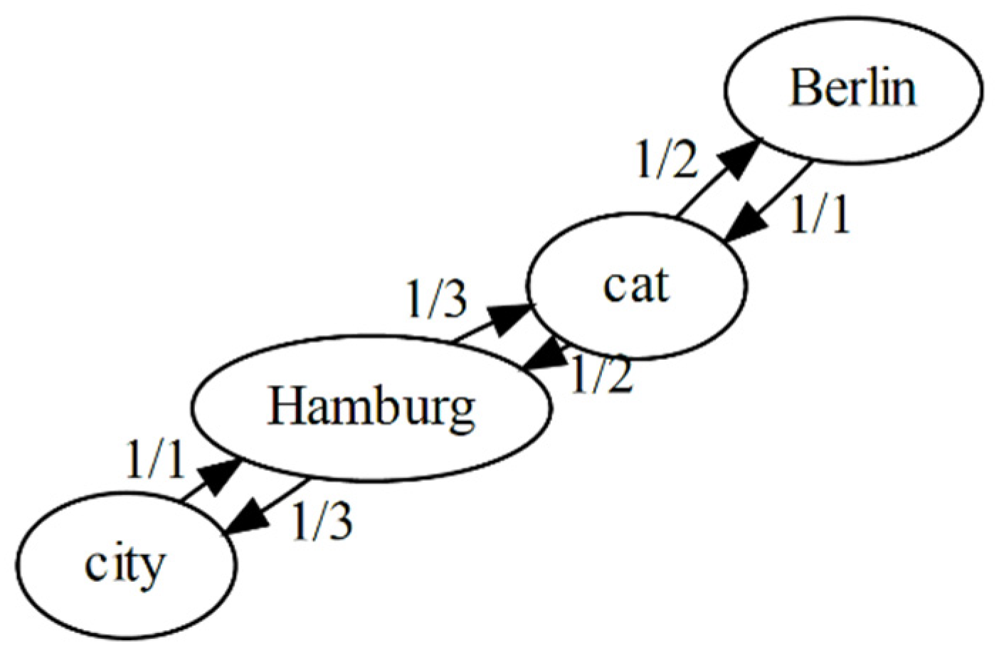
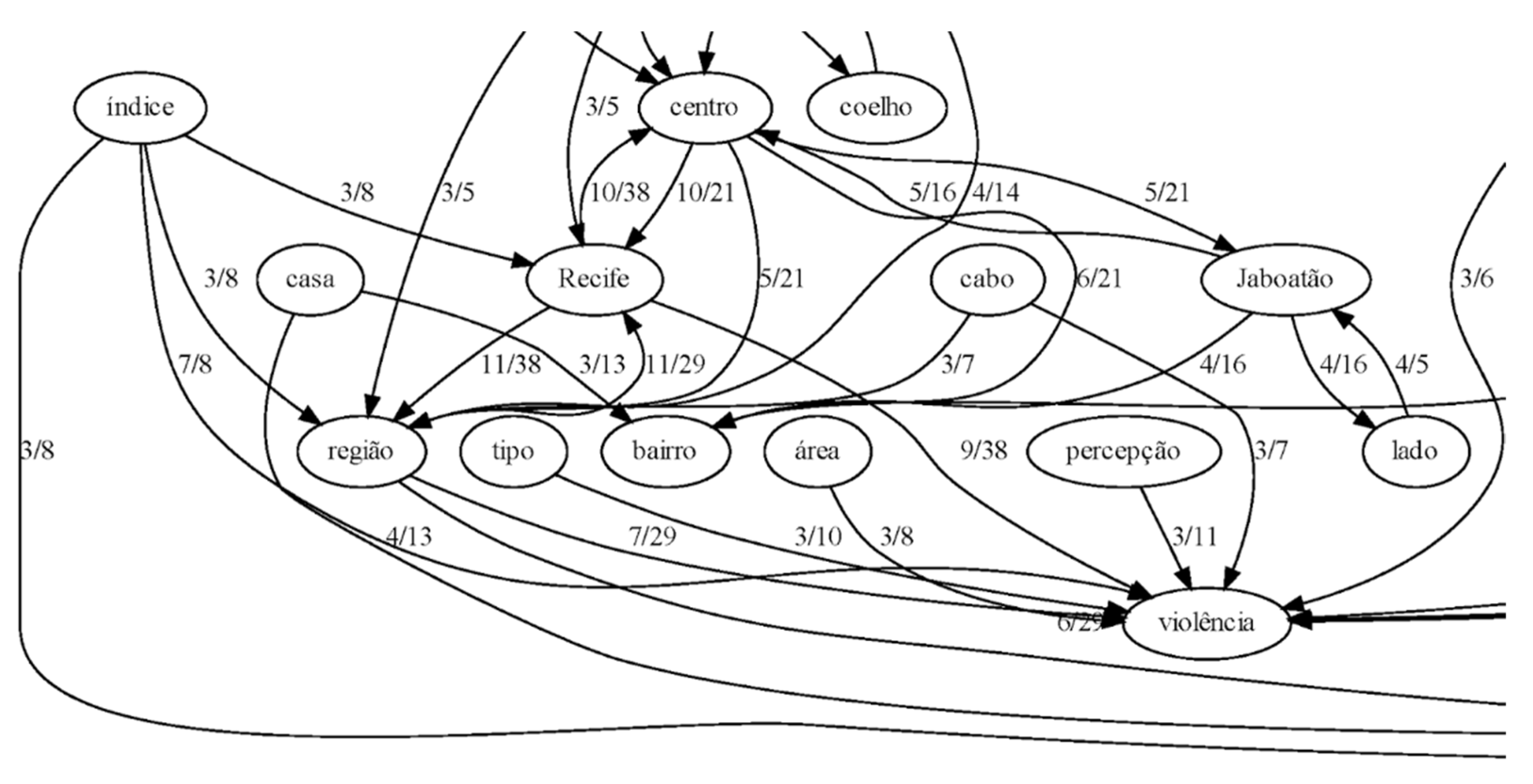
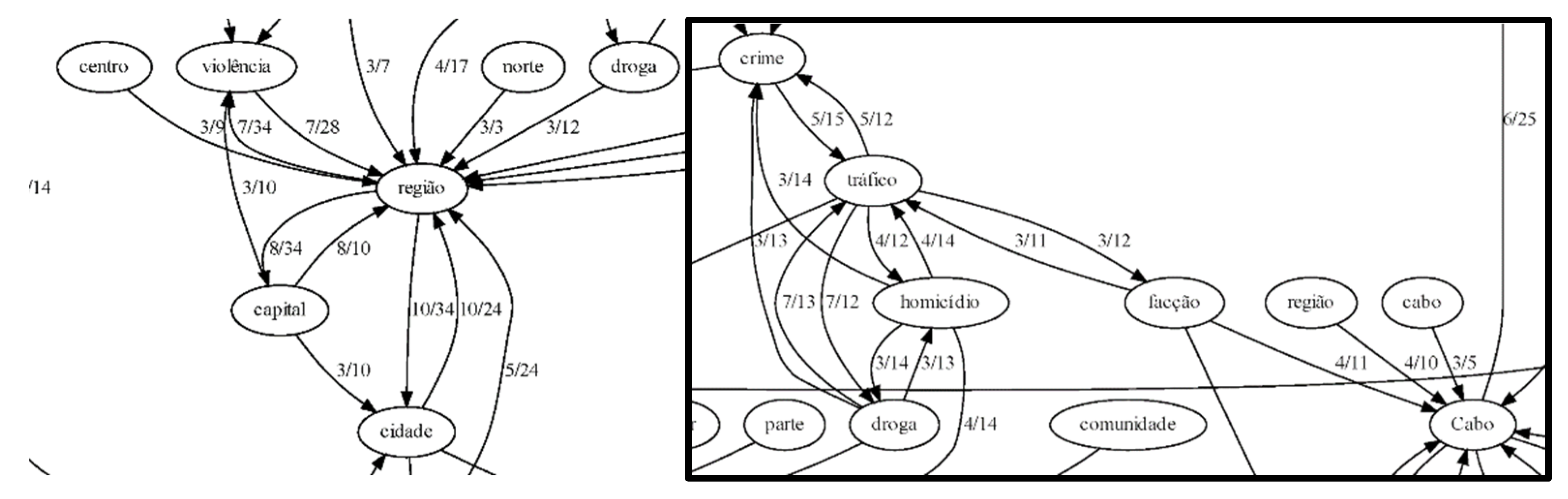
2.2.3. Semi-Automated Text Analysis

Our semi-automated text analysis is based on Dammann [51] and supplemented with a knowledge discovery approach [52,53]. We used two methods for exploring the texts semi-quantitatively: (1) a simple word cloud approach for visual knowledge mining [54,55]; and (2) a deeper approach using a novel technique for generating cooccurrence graphs. For feasibility, we did not follow a full knowledge extraction like Haarmann [56] or Janowicz et al. [57]; rather, we generalized collocation approaches [58] by using the bag of nouns technique to analyse sentences [59] and thereby extract the association rules between terms [60]. The extracted association rules provide insights into significant bindings from noun-terms to context-terms. Figure 1 illustrates the process using a simplified fictional example: “We live in Hamburg. We find Hamburg to be a nice city. Our cat is with us in Hamburg. The cat ran away to Berlin” After selecting the nouns ‘cat’, ‘city’, ‘Berlin’, and ‘Hamburg’ from a text corpus, the occurrences of each word are counted. ‘Cat’ occurs in two sentences, ‘city’ in one, ‘Berlin’ in one, and ‘Hamburg’ in three. Association rules are then computed based on cooccurrences: because ‘cat’ occurs alongside one of the three occurrences of ‘Hamburg’, the term ‘Hamburg’ points with an estimated confidence of 0.33 to the context of ‘cat’. However, as ‘Hamburg’ occurs in only one of the two occurrences of ‘cat’, the term ‘cat’ is bound to the context of ‘Hamburg’ with an estimated confidence of 0.5. This anisotropic definition of context binding, when deployed on larger text corpora, can thereby provide a useful automated identification of contextual linkages and point to intersubjectively shared narratives in bodies of text.
In order to apply the association rule extraction to the interview transcripts, we split all transcripts into ‘civilian’ and ‘police’ groups, and then we thematically categorised all texts into three sections: introduction, placial structure of unsafety in Recife before the hotspot map was shown, and placial structure after the map was shown. The natural language processing procedure for the Portuguese language covered tokenization, part-of-speech-tagging, lemmatization, and named entity recognition. As no suitable reference for toponyms could be found, we used a simple candidate extraction built on the common grammatical structures of Brazilian place names (finite automaton). Candidates were evaluated by cross-referencing results against a gazetteer (Nominatim) and spatially constrained by a bounding box for the geographic extent of Brazil. Only nouns were extracted in their lemmatized form. All sentences containing a place name or the term ‘violência’ as additional search terms were selected. As artefacts for visual data mining, we thereafter computed (i) a word cloud for each search term (place name or ‘violência’), and (ii) a graph of the association rules for all selected nouns for each of the categories.

2.2.4. Synthesis

The results from the interviews and text analysis were examined and thematically categorised based on the authors’ interpretations of the results and informant quotations were selected to illustrate particularly relevant findings. The place names identified with unsafety were selected and manually mapped by the participant groups (civilian/police) to illustrate and compare the observed differences in their perceptions of unsafety in the study area. For the results, we focused particularly on the forms of spatial bindings and the roles of various types of VGI, including the map shown during the interviews, in the perceptions and narratives that placed unsafety in the landscape.

3. Results and Interpretation

A total of 3610 firearm-related incidents were reported in the Fogo Cruzado dataset for the study area and mapped. Notable spatial clusters are observed predominantly in low-income neighbourhoods, informal settlements, the city centre, and beach districts. These clusters tend to be highly localised at the sub-neighbourhood scale. The map shown to participants is displayed in Figure 2 below. A description and analysis of the spatiotemporal patterns observed in these data are not within the scope of this report and are therefore excluded.

3.1. Mobility

In the study region, the workday for the majority of the population begins in the early hours, with recreational activity taking place largely in the late evening; this results in a high degree of mobility through the city and as such, residents are continually assessing their mobility options to optimise not only time, but also safety. Their daily trajectories from their homes to their workplaces, football pitches, or social clubs involve a decision-making process based on a range of assumptions, such as the optimal time to take public transit and which routes or neighbourhoods to avoid. These considerations are built upon different sources of information, such as social media, television, messaging apps, personal experiences, and non-digital interpersonal networks. The process of evaluating information related to mobility and safety results in people building individual mental maps of the urban landscape.
All informants used or continue to use public transportation (mostly buses) to travel to their workplace. Among the civilian informants, their narratives highlighted the use of buses as the most vulnerable or potentially unsafe moment they face in their daily routine. Narratives about danger and violent acts in buses were prominent in all interviews with civilians, for example:
Int.: Are you afraid of taking public transportation?
Participant n. 6: Who isn’t?! Yes, I am. Here it is normal to be afraid of public transportation. But there isn’t just one fear; there are many! We know what happens there, but we need to take it. We cannot just refuse to take it. There isn’t another option. So, safety in public transportation does not exist here, either because of violence or the issues inherent to the transportation system.
Fear in this context features a direct relation to the daily concerns of those who must take buses to move through the city. The perception of danger of being a victim of theft, robbery, or assault serves as a strong motivator to change routes, purchase a car if affordable (Participants 1, 6), use alternative transport options (Uber, taxis, chartered busses; Participants 2, 3, 5) or even move to strategic places where they feel safer (Participant 5). Conversely, the police officers were not using public transportation and considered the danger aboard buses to be a part of the broader violent context of the study area and its most notorious neighbourhoods. While the police officers portrayed a more distanced perspective on the spatiality of violence and mobility in Recife, civilian informants often described personal experiences of violence or unsafety.
Participant n. 4: I was living in the metropolitan area before in a city close to Recife. I was living in Camaragibe. I had two horrible experiences with robbery. Those experiences traumatized me. So, I decided to live close to my work. I did that to avoid using public busses.
Participant n. 1: [...] There was always the fear of being robbed. I was so afraid of it that my mother saved money and bought me a car. We did that to reduce the risks. Especially because I had to do the medical training and I had to circulate among different community health facilities over the city. And those facilities are located in [unsafe neighbourhoods]. Being a woman taking the bus alone in those communities is just too dangerous. With a car, it will be safer.
The perception of vulnerability and unsafety in public transportation appears to be largely related to place, route, and type of public transport (buses or underground), as well as one’s gender and occupation. Although male participants also expressed fear of travelling on buses, female participants related more vividly and in more detail the range of possible violent acts to which one might fall victim whilst taking public transportation. Buses connecting metropolitan areas and the city Recife usually require a longer journey and travel through multiple communities and neighbourhoods known for higher rates of violence, which increases one’s sense of unsafety and vulnerability.
Participant 5: Actually I feel fear. You know, we do not feel safe at all! So, you take a bus here at the BR (Federal Road), as I do everyday. So, I see two or three men entering the bus in the BR and they do “o rapa” (rob everyone at once [i.e., an armed holdup]). So, that is exactly our fear. We take the bus everyday but we do not know what is going to happen. We do not know if we will come back home safe and alive.
These reflections on participants’ own daily routines highlight the frustration faced when one is forced to weigh their perceived safety against essential mobility needs, particularly in the context of public transit use. The highly publicised cases of armed robbery play a central role in the perception of unsafety for people who must travel along the major corridors linking the city of Recife with its surrounding communities and peripheral towns. The information flows from official news sources, social media (e.g., Twitter), and informal social networks within the community (e.g., WhatsApp groups) significantly shape the spatiality of residents’ perception of risk. For example, Participant no. 5 had, at the time of the interview, never been a victim of an armed robbery, but her perceptions and decisions regarding mobility were largely shaped by these information flows. The influence of television sources was prominent amongst all participants, although several expressed a general distrust or suspicion of official media sources, rather indicating a preference for unofficial sources or materials spread through social media.
Participant 6: […] we see on television robberies taking place on the bus. You see it several times. So, you feel unsafe on the bus. So, you have to stay vigilant, pay attention to what people are doing and look for a strategic place to sit because you may have to be ready to get off of the bus immediately.
Participant n. 3: In my perception, violent acts increased in Recife and the Metropolitan area. I follow the news on television and I see that. Violence is for sure growing.
From these findings, we interpret the very sense of mobility as the sense-making of movement [61], in which places of violence are not only liquid or restructuring [30]; they quite literally move through the urban landscape as ethereal geographical entities! In this sense, unsafety itself is continually constituted through ongoing individual evaluation processes along time-geographic tubes that intersect areas that are considered unsafe and as such, these tubes assume unsafety themselves, e.g., the commuter bus lines described above. As unsafety is bound to such time-geographic contexts, unsafety itself is therefore projected onto places as constructed by (social) media.

3.2. Sources of “Everyday VGI”

The perception of unsafety and the risk of experiencing an act of violence motivates the inhabitants to seek information in order to inform their decisions and empower themselves to react accordingly, resulting in a sense of reduced vulnerability. In this context, digital media play a crucial role, through which they gather information about the streets, communities, neighbourhoods, and areas in which an elevated risk of victimisation may (or may not) exist. Traditional media, such as television, newspapers, and radio, continue to play a central role in our informants’ perceptions of safety in the study area. In recent years, the sources of relevant information have grown to include sources accessible through mobile phones and computers, and sources from non-official sources. The distributed information often draws upon centralised media, such as local television news reports, which are accessed via YouTube and Instagram and distributed through social media and messaging applications (primarily WhatsApp and Telegram). In violent areas, such as Recife and its surrounding metropolitan area, residents are constantly exchanging news about violent acts, even if the source and veracity of the information is uncertain.
Interviewer: How did you know that those places are dangerous and violent?
Participant n. 2: I find out through social networks, friends, colleagues [...] TV news and social media.
Throughout the interview process, one particular local TV news show became exceptionally prominent: Cardinot. The host Joslei Cardinot uses a common format for local news in Brazil: lunchtime reporting, predominantly focussed on violent acts in disadvantaged areas of the city. Cardinot was featured daily on live TV, YouTube, and Instagram, and is viewed by thousands of residents of Recife. The show features dynamic camera angles and dramatic background music typical of the genre, and Cardinot speaks directly to the viewer with an assertive tone.
Participant n. 6:[...] Cardinot TV show is extremely famous here. Everybody watches his program at lunchtime to see all the violent cases that happened during the day.
Participant n. 1:[...] Cadinot is a very famous reporter here regarding community journalism. Cardinot shows the violence in the communities here in Recife and Metropolitan areas. He also has an Instagram account with the news [...].
Informants indicated that Cardinot and similar TV programmes were highly influential in their perception of violence in Recife, and framed the show as both an ‘infotainment’ mass-media mechanism using poverty and violence to attract attention, as well as a voice of the people—particularly of socioeconomically disadvantaged residents.
While the show is hosted by an official TV station (TV Tribuna), the programme strongly encouraged members of the general public to provide information via a WhatsApp number at the bottom of the screen. They are asked to report local issues and events, and the platform then distributes their input through a ticker along the bottom of the screen as well as through featured quotes and arguments in news segments. The reliability of the information was a concern of the majority of the interviewed residents. Despite this scepticism, residents often distribute the information through social media without cross-checking its veracity against other sources.
Participant n. 4:[...] Actually, I try to filter all the information I get before reposting it. Not everyone does what I do, but I really try to repost things that are important [...]. I only repost things on WhatsApp that I know are important to my contacts.
The constant daily flow of news from the general public to and from traditional sources like Cardinot constantly shapes and reshapes individuals’ mental maps of unsafety in the study area. Conversely, the police officers who were interviewed were predominantly influenced by their individual work experiences and information internal to the police services. They unanimously indicated a lack of time for digital media and did not share news about violence via social media.
Ongoing evaluation of situational risk of violence creates a demand for the most up-to-date knowledge available, which is most often the product of “everyday VGI” distributed through social media and viewer-informed programmes like Cardinot. Static maps as information artifacts feature a critical delay and therefore were not considered to be helpful for citizens’ evaluation of safety. Participants rather used a combination of three sources: (1) reports from their individual network of trusted colleagues, family, or friends; (2) prominent TV shows like Cardinot, which act as an information multiplier by soliciting, synthesising, and selectively disseminating VGI via social media; and (3) local knowledge from various sources redistributed through social media. In essence, in addition to our expectation that placement of unsafety relates strongly to everyday language instead of technical artefacts, we were able to identify that VGI of unsafety is not needed in a high spatial resolution, but rather in a high temporal resolution within a network of trust, a task that is not supported by the current map services to date. As such, these informal information sharing networks serve as the primary means by which people create mental maps of unsafety.

3.3. Perception of Dangerous Areas

Two of the three blocks in both sets of interviews explored informants’ perceptions of the spatial distribution of violence before (Figure 2) and after showing them the map generated from VGI data (gun violence reports distributed through the Fogo Cruzado app). The results show similarities and differences before and after having viewed the hotspot map, and reveal a hierarchy of placial references from a sub-neighbourhood level to a broadly subregional level (as subsequently validated in the semiautomated analysis of the interview transcripts, shown below). Initially, informants identified perceived violent spaces related to their daily routines. BOPE officers predominantly mentioned areas across the metropolitan area (e.g., Cabo de Santo Agostinho, Paulista, Itapiçuma), whilst standard patrol officers highlighted neighbourhoods in Recife City and Jaboatão dos Guararapes. The reason for this difference is unclear, as both units are active across the entire study area.
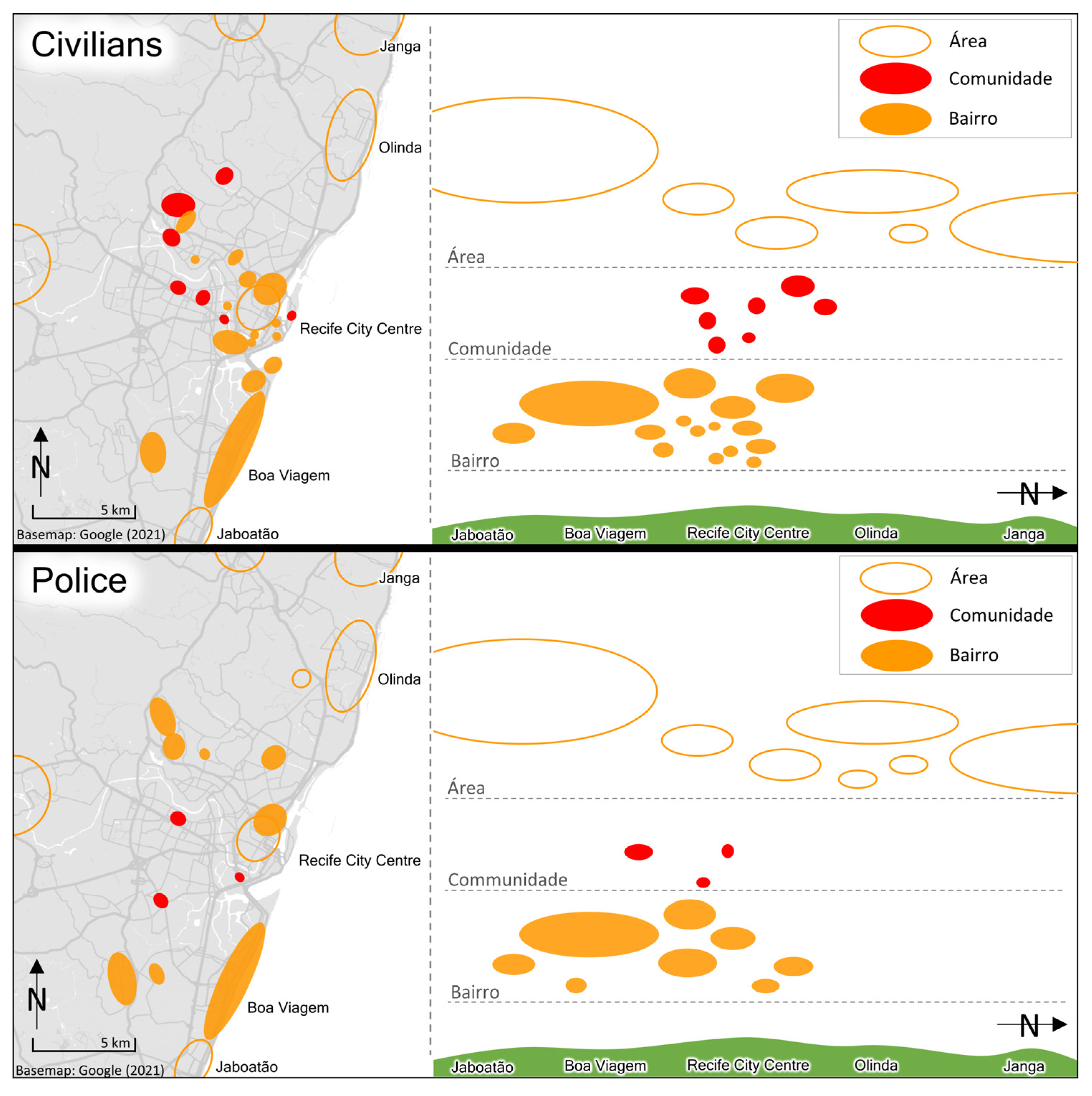
Officer n. 1:Cabo (Cabo de Santo Agostinho) and Ipojuca. On the other side of Recife, there are Itamaracá, Itapissuma, and Paulista. Paulista, in my opinion, is the city with higher rates of violence. These are a kind of small city in the metropolitan area. Jaboatão dos Gauararapes is a big city close to Recife with high rates of criminality in specific neighbourhoods.
Officer n. 4:In my opinion Boa Viagem is the most violent neighbourhood in Recife [...] there are many favelas there. I think Boa Viagem is very violent because of the property crimes like robbery and car theft, and also homicide. According to my experience working in the city centre, I would also say that Santo Amaro and Coque are also very violent.
The informants’ responses prior to being shown the map demonstrate a strong anchoring of violence in toponyms, predominantly for governmental administrative units like neighbourhoods, districts, and precincts. This binding differs from that of the civilian informants, who instead demonstrated a stronger association of violence with particular socioeconomically- or socioculturally-defined places and built environment features of the urban landscape. Figure 3 illustrates differences in the placial references elicited by civilians and police during the interviews, through which a hierarchy of scale in the placial bindings emerged, such that the fuzzy and largely socioeconomically defined área was interspersed with more precise sub-neighbourhood-level references used to refer to more socioeconomically homogenous constructs of communidade, which exist as non-administrative micro-sociocultural entities within the more geometrically-defined bairro (roughly equivalent to neighbourhood, but closer to the German concept of Kiez). Since BOPE at the time was dealing with the expansion of the drug trade in the metropolitan area, the officers often mentioned cities in connection with drug-related violence. Conversely, officers from standard patrol units are more often involved in cases of common street crime; they placed more emphasis on neighbourhoods close to the city centre of Recife and the neighbouring district of Jaboatão dos Guararapes. Civilian informants mostly indicated sites belonging to their daily routines, but unlike the police officers, they demonstrated additional associations of violence with specific features of the built environment, such as bus stops and specific routes.
Participant n. 2:I think the south area of Recife [is more violent]. There are many communities inside of this area. Being inside buses and the metro is also dangerous. In the city centre of Recife, for example, there is a neighbourhood called Santo Amaro. There are many robberies taking place close to the entrance of the metro station. The streets there are strange and full of homeless people. Of course, the probability of risk is higher there.
Prior to viewing the map, the residents focussed their narratives on places and situations they considered to be a risk in their daily routines. Visual perception also appears to be a strong indicator. In the quotation above, streets with homeless people are considered to be risky for those who take public transportation. Additionally, the communities and favelas were prominent in both civilians’ and officers’ perceptions of violence, with strong cognitive linkages to socioeconomic deprivation. The term community (comunidade) is mainly used to indicate an area where individuals have developed a collective identity. This identity is externalized in a sense of sociocultural belonging. The community can be composed of a street (or streets), housing area, neighbourhood, or even an entire city. However, community is also used as a substitute for the term favela, since ‘comunidade’ has become a more efficient way to express a socially organized collective identity or cultural membership at the neighbourhood scale. So, while the term favela has a negative connotation related to the drug trade and criminality, the term ‘comunidade’ highlights a positive sense of collective organization not related to criminality.
The interviewees’ interactions with the VGI-based map differed significantly between the civilian and police informants. The police officers appeared to quickly understand the spatial distribution of crime portrayed on the maps. Conversely, several of the civilian informants required some explanation and facilitation to read the map, identify the various neighbourhoods, and cognitively place the hotspots. During the analysis of the map, the residents agreed with the data presented and associated the hotspots with news stories from digital media. However, the police officers were significantly more critical of the VGI data, for example, in suggesting that the intensity of violence in some spaces was underrepresented on the map.
Participant n. 2:The map is true. It is reporting reality because it is exactly those areas that we see in the news.
Officer n. 3:I think Jaboatão should be more red. There are missing data in this map [...]. However, this area in Cabo (de Santo Agostinho) is really violent. As I told you before, the city centre of Cabo (de Santo Agostinho), Cohab, and Charnequinha are really violent. So, the red spot there is correct. Recife is also correct but still missing some data in the Nova Descoberta neighbourhood.
The quotations above reflect the interviewees’ reactions to the VGI map shown at the beginning of the second interview block. The majority of the civilians argued that the map represents their perception of violent spaces based on their routine experiences, news from social media, and official news. Police officers were quickly able to relate professional knowledge and experiences to the data portrayed in the VGI maps.
Almost expectedly, the daily routines of our participants acted as a filter on their perception of unsafety in Recife. Interestingly, being asked for their perception of dangerous areas resulted in abstract and often vague spatial references like “suburbs” or even directions (e.g., “south”). Switching from descriptions of their everyday situational practice to questions about spaces immediately turned a high-resolution situational awareness into the distant, comprising vague and liquid geographies [30].
Our observations during the interview indicate that a degree of experience with crime maps amongst police officers enabled them to quickly orientate their experiential knowledge with the map and contrast the information shown against their expectations from their own cognitive artefacts. Civilians often required facilitation and related the information to other sources such as TV news, interpreting the map as an additional source of information. Maps of the VGI data thereby serve a general purpose as static artefacts but were not effective in informing the daily information (needs) of our participants, due to their time lag and challenges in map-reading.

3.4. Narratives Binding the Spatial Perception of Danger

The final step in this analysis intersects the results from the semiautomated co-occurrence graphs with the interview results.
The co-occurrence graphs from the second block of interviews with civilians, shown in Figure 4, featured a strong prevalence of, and connectivity to, the term polícia (police). The strongest associations were with geographical domains, such as community (comunidade), area (área), and spot (ponto, local), as well as individual people’s concerns about the occurrence (ocorrência) of violent acts, risk (risco), and lack of police forces on the streets (policiamento). The abbreviation SAMU (Serviço de Atendimento Móvel de Urgência/Mobile First-Aid Service) also exhibits a strong co-occurrence with violence since this service requires a police presence in the case a violent act or suspected violent act. The sense of safety amongst civilian informants therefore features strong links with space and the presence of police forces. The same is true in the inverse: sites with a lack of police surveillance feature an increased sense of danger and risk.
Participant n. 3: I feel a bit more safe in places with large movements of people such as the beach sidewalk, for example. Of course it will depend on time [of day] and if the police forces are there. Jaqueira Park, for example, there is always police there during the day. So, I feel safe there.
In the third interview block with civilians, during which a more detailed discussion of spatiality and the VGI map was conducted, violence emerges as an important node with strong linkages to geographical domains, such as region (região), areas (área), Cabo (the city of Cabo de Santo Agostinho), community (comunidade), and terms reflecting individual emotional states/responses to violence and the fear of violence. Terms such as rate (índice), occurrence (ocorrência), policy (política), and investment (investimento) also highlight the temporal, policy, and socioeconomic dimensions of residents’ concerns in response to recent increases in rates of violence in the study area.
Participant n. 5:Unfortunately, we have violence everywhere. There is a lot of criminality, violence against women, violence against children, violence when they kidnap people, in robbery, homicide, everything! [...] I know that violence is everywhere: here in Jaboatão (dos Guararapes) and Recife we see everyday violent acts in the afternoon news. [...] there is no public investment in safety.
The co-occurrence graphs based on police officers’ narratives (Figure 5) show a clear relation between geographical domains of violent crime and the drug trade as an explanatory factor for the recent increases in violence in the study area. Considering that the majority of the police officers were from BOPE (Special Police Operations Battalion) and were engaged in strategic, tactical, and often repressive measures to contain the expansion of the drug trade in the metropolitan area, the observed similarity of the narratives before and after being shown the map is not unexpected.
The co-occurrence graphs based on the second block of interviews feature the word region (região) as the most prominent central node. These were closely related to other geographical domains such as north (norte), capital (capital city), city (cidade), city-centre (centro), spot (ponto), and the area Ipojuca. The other prominent terms, trade (tráfico), rates (indice), and violence (violência), reflect the cognitive binding of the drug trade and violence within those geographical domains. The third block of the interview continued the patterns of the previous block and demonstrated a linearity of the police officers’ discourses on the relation of space and violent criminal activity. However, the terms in this graph also highlight the structure of the criminal activity and its association with geographical domains. The word tráfico (drug trade) is connected with homicide (homicídio), crime (crime), drug (droga), individual person (pessoa), and facção. The term facção also features very strong geographical bindings common with the drug trade, particularly to the cities Cabo de Santo Agostinho, Ipojuca, Itamaracá, and Itapissuma, all of which are located in the metropolitan area of Recife. Some of these observed patterns of association were also explicitly reflected in the interview transcripts.
Officer n. 1: So, the majority of violent crimes are related to the drug trade in both the south and the north part of the metropolitan area. There is a ‘facção’ there that initially was created in the municipality of Ipojuca called “trem bala” and now runs the drug trade there. Before this facçcão, the drug trade was decentralized, but now this facção manages the drug trade in the region of Cabo de Santo Agostinho and Ipojuca.
As BOPE operations primarily target the drug trade, they may have overstated the role of the drug trade in violence. Interestingly, we found that by directing asking informants about places of unsafety and utilising the co-occurrence graphs, additional contextual information about the structure of everyday geographies of unsafety was revealed. By explicitly naming regions, areas, and communities as concepts that bind the cognitive-emotional perceptions and experiences of unsafety, the study revealed levels of spatial granularity in how knowledge about unsafety is placially bound prior to viewing a cartographic artefact. In contrast to the levels of spatiality used for route descriptions [23], these bindings occur on a high level of aggregation or even on an ambiguous scale, as in the case of communities (as describe above). After the intervention, a tendency to relate new information to one’s own experiences became clear when referring to specific sites, but even this binding used various shifters (centre, North) to describe areas of unsafety more precisely. Descriptions of the sites remained liquid [30]. Perhaps more interestingly, our text mining method proved to be sensitive enough to identify and highlight frequent lines of argumentation used by several participants.

4. Discussion

In carefully looking for adequate VGI solutions in the context of unsafe places, given our theoretical vantage point, we were able to observe significant shifts in a number of components of our initial questions themselves:
(a)
From VGI maps to social media: Beside technical solutions providing the opportunity to report individual observations of violence like gun shootings, mediated social media channels revealed to have much more impact on day-to-day communications than map artefacts.
(b)
The update problem: One reason for the advantage of simple social media solutions is that map artefacts have one important conceptual limitation: As maps are aggregate artefacts derived from different information sources, tracking a dynamically developing topic like violence leads to visualisations that usually rely on outdated, incomplete or even conflicting information. Rendering maps on a daily basis will overcome the update problem only at the cost of sparse data not suitable for aggregation at all.
(c)
From containers to mobility: Reflecting the update problem on its cognitive end, even for human agents generalising observations of violence on the level of dangerous regions remains too vague for decision-making. As we were able to obtain from the example of public transportation, dangerous spaces can be shifters even themselves.
(d)
Background framing: Depending on the professional group, different indicators (like signs of drug trade) were monitored closely by individuals to obtain additional information on where to go and where not to go.
In essence, modelling palatial knowledge on unsafe places as an everyday existential question is not a task easy to solve by current VGI solutions. In this context, our study provided insights into the patterns and strategies applied by our participants to deal with outdated or incomplete placial information. All further efforts in regional policies to assist those strategies will have to deal with the conceptual shifts observed above.

5. Reflection and Conclusions

The multimethod approach used in this study enabled the identification of key linkages in the perception of place and violence in metropolitan Recife and facilitated an empirical differentiation between the placial bindings of violence between civilian and police participants. The semi-structured interviews highlighted several prominent dynamics through which one’s individual routines and information flows through formal and informal networks relate to their perception of the landscape of violence in the study area. By exploring the placialities of unsafety before and after viewing mapped VGI data, we were able to observe both the ways in which information flows and lived experiences contribute to the construction of landscapes of violence. To what degree the various sources of information were considered trustworthy varied between the civilian and police informants, and underscored fundamentally different understandings of the associations between space and violence in the Brazilian context whilst also providing insight into the blurred boundaries between informal VGI (e.g., dialogue in WhatsApp groups), curated VGI (e.g., Fogo Cruzado data), and formalised VGI (e.g., Cardinot). In this sense, the citizens as producers of geographic knowledge and information interface with a variety of structures and processes and conduct citizen science in a variety of ways [37]. For example, the more direct means of making observations and sharing in informal WhatsApp groups excludes formal structures and state actors and thereby constitutes a space for exchanging geographic knowledge moderated only by social norms and expectations. Conversely, as a data schema that reports guidelines, filters, and post-moderation positions, Fogo Cruzado was used as an intervening arbiter of placial information, both in its role as a platform (i.e., a node for convening citizen actors as observers) and as an organisation with the explicit mandate to inform citizens about violent incidents and mediate between the public as a producer and the public as a consumer of information. The example of the Cardinot programme introduces an additional layer of ambiguity in the distinction between VGI as an implicitly anti-hierarchical, democratising, and empowering means of knowledge exchange against the traditional, top–down dynamic of mainstream media actors reproducing information hegemonies. As much of the information communicated in programmes such as Cardinot is editorialised citizen reports with a distinct entertainment function (in addition to its purpose as a means of informing the public), one may argue that the VGI itself is co-opted and leveraged as both a data source and as a socio-political symbol or tokenistic representation of engagement and empowerment. In this sense, a positioning of the citizen as a scientific actor and producer of geographic knowledge should be subject to scepticism, underscoring the necessity for more critical engagement with the political dimensionalities of VGI as a form of citizen science [38,62].
This study benefited significantly from the use of a novel, semiautomated association rule mining method to identify contextual linkages between elements and arguments within the interviews and present semantic typologies (co-occurrence graphs), which not only enabled a deeper evaluation of qualitative data but also served to assist with validating the results from the coding process and the interpretation of codes. At least in the context of violence in the study area, we see that the exchange of everyday geographic knowledge through formal and informal networks and channels comprises a key element in the construction of place. In contrast, we also observed that TV shows and social media outside of private networks of trust appear to supplement and multiply these effects. Map-incorporated VGI data proved to be effective as a means of intervention and triggering the placial anchoring of information and retellings of experience. Even then, vague aggregate references on the level of regions and neighbourhoods played a prominent and somewhat unclear role. These results will require other regional studies as comparatives which may capture the effects of sociocultural differences.
Methodologically, we were able to conclude that directed co-occurrence graphs [58] are very sensitive instruments to pick up repeating lines of argumentation, even at low frequencies. Focusing on semantic topologies more than looking at Cartesian space proved to be a solid ground for an analysis of the regionalization effects of unsafety in everyday practice. The use of maps appears to improve civilians’ ability to more precisely place the intersections between geographical domains/scales, individual knowledge/experience, and the cognitive-emotional experiences of perceived unsafety in day-to-day life.
From the theoretical vantage point of volunteered geographic information and placially-bound knowledge, we were able to empirically demonstrate a concordance with the literature, in that individual knowledge and experience of unsafety is primarily bound to narratives about place [15]. Perhaps more interesting is the observation that the act of viewing high-resolution maps of crime and violence [11] does not appear to mediate or replace the centrality of narratives in constructions of unsafety; rather, they were observed to actually enhance them. As civilians in Recife search for dynamic information concerning crime places in a high temporal resolution for everyday situational decision-making, asking them for places of unsafety confirmed the liquid and vague spatial references observed in earlier studies [30]. Additionally, unlike spatial references from route descriptions [22], talking about places of unsafety led to descriptions with a high level of spatial aggregation. In response, we call for GIS models in the sense of geographical imagination systems [63,64] that can overcome the limitations of common VGI maps and focus on the temporality and hierarchical structure of everyday narrations of unsafe places. In essence, from the perspective of geo-modelling, severe doubts pertain if maps as two-dimensional Cartesian artefacts are suitable to do the job at all. Beside the complementary techniques used in this article utilising basic lexicometric methods (see [51]), additional complementary models, such as place graphs (e.g., [16]) representing and relating individual knowledge about space and place, might further deepen the understanding of different narratives on places of unsafety.

Author Contributions

Conceptualization, Blake Byron Walker, Dominik Kremer and Cléssio Moura de Souza; methodology, Cléssio Moura de Souza, Dominik Kremer and Blake Byron Walker; software, Dominik Kremer, Cléssio Moura de Souza and Blake Byron Walker; validation, Dominik Kremer, Cléssio Moura de Souza and Blake Byron Walker; formal analysis, Cléssio Moura de Souza, Dominik Kremer and Blake Byron Walker; investigation, Cléssio Moura de Souza, Dominik Kremer and Blake Byron Walker; resources, Blake Byron Walker; data curation, Cléssio Moura de Souza, Dominik Kremer and Blake Byron Walker; writing—original draft preparation, Dominik Kremer, Cléssio Moura de Souza and Blake Byron Walker; writing—review and editing, Blake Byron Walker, Dominik Kremer and Cléssio Moura de Souza; visualisation, Dominik Kremer and Blake Byron Walker; supervision, Blake Byron Walker; project administration, Blake Byron Walker; funding acquisition, Blake Byron Walker. All authors have read and agreed to the published version of the manuscript.

Funding

This research received no external funding. C.M.S.’s position is supported by the Faculty of Natural Sciences and the Institute for Geography at Friedrich-Alexander-Universität, Erlangen-Nürnberg. D.K.’s position is supported by Friedrich-Alexander-Universität, Erlangen-Nürnberg. B.B.W.’s position is supported by the German Federal Ministry for Education and Research (BMBF). The authors acknowledge financial support by Deutsche Forschungsgemeinschaft and Friedrich-Alexander-Universität Erlangen-Nürnberg within the funding programme "Open Access Publication Funding".

Data Availability Statement

Fogo Cruzado graciously provides their data free of charge via their API at https://fogocruzado.org.br/sobre-a-api/.

Acknowledgments

The authors wish to thank all study informants for their time and willingness participate in this study and Fogo Cruzado for making their data publicly available. The authors also thank Anton Leutner for providing the initial VGI map and Andreas Wagner for contributing to the methodological development of the text mining tool.

Conflicts of Interest

The authors declare no conflict of interest.

References

  1. Bryant, K. Chicago School of Criminology. In The Encyclopedia of Theoretical Criminology; Miller, J., Ed.; Wiley-Blackwell: Chichester, UK, 2014; pp. 1–3. ISBN 978-1-118-517-390. [Google Scholar]
  2. Matlovicova, K. Theoretical Framework of the Intra-Urban Criminality Research: Main Approaches in the Criminological Thought. Folia Geogr. 2014, 2, 29–40. [Google Scholar]
  3. Zahnow, R.; Wickes, R. Violence and Aggression in Socially Disorganized Neighborhoods. In The Wiley Handbook of Violence and Aggression; Sturmey, P., Ed.; Wiley Blackwell: New York, NY, USA, 2017; pp. 1–12. ISBN 978-1-119-05755-0. [Google Scholar]
  4. Jefferson, B. Digitize and Punish: Racial Criminalization in the Digital Age; University of Minnesota Press: Minneapolis, MN, USA, 2020; ISBN 978-1-5179-0923-9. [Google Scholar]
  5. Garland, D. The Culture of Control: Crime and Social Order in Contemporary Society; University of Chicago Press: Chicago, IL, USA, 2002; ISBN 978-022-628-384-5. [Google Scholar]
  6. Hall, S. The Spectacle of the ‘Other’. In Representation: Cultural Representations and Signifying Practices, 2nd ed.; Hall, S., Evans, J., Nixon, S., Eds.; SAGE: London, UK, 2013; pp. 215–287. ISBN 978-184-920-547-4. [Google Scholar]
  7. Eck, J.; Weisburd, D. Crime Places in Crime Theory. In Crime and Place; Eck, J., Weisburd, D., Eds.; Criminal Justice Press: Monsey, NY, USA, 1995; pp. 1–33. [Google Scholar]
  8. Weisburd, D. The Law of Crime Concentration and the Criminology of Place. Criminology 2015, 53, 133–157. [Google Scholar] [CrossRef]
  9. Weisburd, D.; Wire, S. Crime Hot Spots. In Oxford Research Encyclopedia of Criminology and Criminal Justice; Pontell, H., Ed.; Oxford University Press: Oxford, UK, 2016; ISBN 978-019-026-407-9. [Google Scholar]
  10. Brantingham, P.; Brantingham, P. Criminality of place: Crime generators and crime attractors. Eur. J. Crim. Policy Res. 1995, 3, 5–26. [Google Scholar] [CrossRef]
  11. Weisburd, D.; Groff, E.; Yang, S.-M.; Telep, C. Criminology of Place. In Encyclopedia of Criminology and Criminal Justice; Bruinsma, G., Weisburd, D., Eds.; Springer: New York, NY, USA, 2014; pp. 848–857. ISBN 978-1-4614-5689-6. [Google Scholar]
  12. Schneider, R.H.; Kitchen, A.T. Planning For Crime Prevention: A Transatlantic Perspective; Routledge: New York, NY, USA, 2002; ISBN 978-041-524-136-6. [Google Scholar]
  13. Brantingham, P.J.; Brantingham, P.L.; Song, J.; Spicer, V. Crime Hot Spots, Crime Corridors and the Journey to Crime: An Expanded Theoretical Model of the Generation of Crime Concentrations. In Geographies of Behavioural Health, Crime, and Disorder; Lersch, K., Chakraborty, J., Eds.; Springer: Cham, Germany, 2020; pp. 61–86. ISBN 978-3-030-33467-3. [Google Scholar]
  14. Schatzki, T. The Site of the Social: A Philosophical Account of the Constitution of Social Life and Change; Penn State University Press: University Park, PA, USA, 2002; ISBN 978-0-271-02292-5. [Google Scholar]
  15. Cresswell, T. Place: A Short Introduction; Blackwell Pub.: Malden, MA, USA, 2004; ISBN 978-1405-10671-9. [Google Scholar]
  16. Kremer, D. Rekonstruktion von Orten als Sozialem Phänomen: Geoinformatische Analyse Semantisch Annotierter Verhaltensdaten; UBP: Bamberg, Germany, 2018; ISBN 978-3-86309-579-6. [Google Scholar]
  17. Werlen, B. Sozialgeographie Alltäglicher Regionalisierungen: Band 2: Globalisierung, Region und Regionalisierung; Franz Steiner Verlag: Stuttgart, Germany, 1997; ISBN 351-506-607-1. [Google Scholar]
  18. Schlottmann, A. RaumSprache: Ost-West-Differenzen in der Berichterstattung zur Deutschen Einheit. Eine Sozialgeographische Theorie; Franz Steiner Verlag: Stuttgart, Germany, 2005; ISBN 978-3-515-08700-1. [Google Scholar]
  19. Weichhart, P.; Weixlbaumer, N. Lebensqualität und Stadtteilsbewußtsein in Lehen: Ein stigmatisiertes Salzburger Stadtviertel im Urteil seiner Bewohner. In Beiträge zur Geographie von Salzburg, Zum 25-jährigen Bestehen des Institutes für Geographie der Universität Salzburg und zum 21. Deutschen Schulgeographentag in Salzburg; Riedl, H., Ed.; Selbstverl. d. Inst. für Geographie d. Univ. Salzburg: Salzburg, AT, USA, 1988; pp. 230–271. [Google Scholar]
  20. Felgenhauer, T. Geographie als Argument: Eine Untersuchung regionalisierender Begründungspraxis am Beispiel “Mitteldeutschland; Franz Steiner Verlag: Stuttgart, Germany, 2007; ISBN 978-3-515-09078-0. [Google Scholar]
  21. Winter, S.; Freksa, C. Approaching the notion of place by contrast. J. Spat. Inf. Sci. 2012, 31–50. Available online: https://tinyurl.com/p8xja78h (accessed on 18 November 2021).
  22. Richter, D.; Winter, S.; Richter, K.-F.; Stirling, L. How People Describe Their Place: Identifying Predominant Types of Place Descriptions. In GEOCROWD ’12, Proceedings of the 1st ACM SIGSPATIAL International Workshop on Crowdsourced and Volunteered Geographic Information, Redondo Beach, CA, USA, 6 November 2012; Goodchild, M., Pfoser, D., Sui, D., Eds.; Goodchild, M., Pfoser, D., Sui, D., Eds.; Association for Computing Machinery: New York, NY, USA, 2012; pp. 30–37. [Google Scholar]
  23. Richter, D.; Vasardani, M.; Stirling, L.; Richter, K.-F.; Winter, S. Zooming In–Zooming Out Hierarchies in Place Descriptions. In Progress in Location-Based Services; Krisp, J., Ed.; Springer: Berlin, Germany, 2013; pp. 339–355. [Google Scholar]
  24. Belina, B.; Kreissl, R.; Kretschmann, A.; Ostermeier, L. (Eds.) Kritische Kriminologie und Sicherheit, Staat und Gouvernementalität: 10. Beiheft Kriminologisches Journal; Beltz: Weinheim, Germany, 2012. [Google Scholar]
  25. Belina, B. Kriminalität und Raum: Zur Kritik der Kriminalgeographie und zur Produktion des Raums. Krim. J. 2000, 32, 129–147. [Google Scholar]
  26. Belina, B. Der Alltag der Anderen: Racial Profiling in Deutschland. In Sicherer Alltag? Politiken und Mechanismen der Sicherheitskonstruktion im Alltag; Dollinger, B., Schmidt-Semisch, H., Eds.; Springer VS: Wiesbaden, Germany, 2016; pp. 123–146. [Google Scholar]
  27. Kutschinske, K.; Meier, V. “…sich diesen Raum zu nehmen und sich freizulaufen…”: Angst-Räume als Ausdruck von Geschlechterkonstruktion. Geogr. Helv. 2000, 55, 138–145. [Google Scholar] [CrossRef]
  28. Wucherpfennig, C.; Fleischmann, K. Feministische Geographien und geographische Geschlechterforschung im deutschsprachigen Raum. ACME 2008, 7, 350–376. [Google Scholar]
  29. Glasze, G.; Pütz, R.; Rolfes, M. Die Verräumlichung von (Un-)Sicherheit, Kriminalität und Sicherheitspolitiken: Herausforderungen einer Kritischen Kriminalgeographie. In Diskurs-Stadt-Kriminalität: Städtische (Un-)Sicherheiten aus der Perspektive von Stadtforschung und Kritischer Kriminalgeographie; Glasze, G., Pütz, R., Rolfes, M., Eds.; Transcript: Bielefeld, Germany, 2015; pp. 13–104. ISBN 978-3-8394-0408-9. [Google Scholar]
  30. Redepenning, M.; Neef, H.; Gomes, E. Verflüssigende (Un-) Sicherheiten: Über Räumlichkeiten des Strassenhandels am Beispiel Brasiliens. Geogr. Helv. 2010, 65, 207–216. [Google Scholar] [CrossRef]
  31. Newburn, T.; Stanko, E. (Eds.) Just Boys Doing Business? Men, Masculinities and Crime; Routledge: London, UK, 2013; ISBN 978-1-136-14396-0. [Google Scholar]
  32. Siriaraya, P.; Zhang, Y.; Wang, Y.; Kawai, Y.; Mittal, M.; Jeszenszky, P.; Jatowt, A. Witnessing Crime through Tweets: A Crime Investigation Tool Based on Social Media. In 27th ACM SIGSPATIAL International Conference on Advances in Geographic Information Systems, Proceedings of the ACM SIGSPATIAL GIS 2019, Chicago, IL, USA, 5–8 November 2019; Banei-Kashani, F., Trajcevski, G., Güting, R.H., Kulik, L., Newsam, S., Eds.; Association for Computing Machinery: New York, NY, USA, 2019; pp. 568–571. [Google Scholar]
  33. Prieto Curiel, R.; Cresci, S.; Muntean, C.I.; Bishop, S.R. Crime and its fear in social media. Palgrave Commun. 2020, 6, 1–12. [Google Scholar] [CrossRef]
  34. Goodchild, M.F. Citizens as sensors: The world of volunteered geography. GeoJournal 2007, 69, 211–221. [Google Scholar] [CrossRef]
  35. Walker, B.B.; Rinner, C. A Qualitative Framework for Evaluating Participation on the Geoweb. J. Urban Reg. Inf. Syst. Assoc. 2013, 25, 15–24. [Google Scholar]
  36. Skarlatidou, A.; Haklay, M. (Eds.) Geographic Citizen Science Design: No One Left Behind; UCL Press: London, UK, 2021; ISBN 978-1-78735-612-2. [Google Scholar]
  37. Bonney, R.; Phillips, T.B.; Ballard, H.L.; Enck, J.W. Can citizen science enhance public understanding of science? Public Underst. Sci. 2015, 25, 2–16. [Google Scholar] [CrossRef] [PubMed]
  38. Trojan, J.; Schade, S.; Lemmens, R.; Frantál, B. Citizen science as a new approach in Geography and beyond: Review and reflections. Morav. Geogr. Rep. 2019, 27, 254–264. [Google Scholar] [CrossRef]
  39. Elwood, S.; Goodchild, M.F.; Sui, D.Z. Researching Volunteered Geographic Information: Spatial Data, Geographic Research, and New Social Practice. Ann. Am. Assoc. Geogr. 2012, 102, 571–590. [Google Scholar] [CrossRef]
  40. Tversky, B. Cognitive Maps, Cognitive Collages, and Spatial Mental Models. In Spatial Information Theory. A Theoretical Basis for GIS, Proceedings of the European Conference (COSIT’93), Marciana Marina, IT, 19–22 September 1993; Frank, A., Campari, I., Eds.; Frank, A., Campari, I., Eds.; Springer: Berlin, Germany, 1993; pp. 14–24. [Google Scholar]
  41. United Nations Office on Drugs and Crime. Global Study on Homicide: Executive Summary, Vienna, AT. Available online: https://tinyurl.com/3fv8mrw9 (accessed on 18 November 2021).
  42. Cerqueira, D.; Bueno, S.; Palmieri Alves, P.; de Lima, R.S.; da Silva Enid, R.A.; Ferreira, H.; Pimentel, A.; Barros, B.; Marques, D.; Pacheco, D.; et al. Atlas da Violência 2020. Available online: http://repositorio.ipea.gov.br/handle/11058/10129 (accessed on 5 July 2022).
  43. Madensen, T.; Eck, J. Crime Places and Place Management. In The Oxford Handbook of Criminological Theory; Cullen, F., Wilcox, P., Eds.; Oxford University Press: New York, NY, USA, 2013; pp. 555–578. ISBN 978-0-19-974723-8. [Google Scholar]
  44. Walker, B.B.; Moura de Souza, C.; Pedroso, E.; Lai, R.S.; Hunter, P.; Tam, J.; Cave, I.; Swanlund, D.; Barbosa, K.G. Towards a Situated Spatial Epidemiology of Violence: A Placially-Informed Geospatial Analysis of Homicide in Alagoas, Brazil. Int. J. Environ. Res. Public Health 2020, 17, 9283. [Google Scholar] [CrossRef]
  45. Barbosa, K.G.; Walker, B.B.; Da Vieira Silva, A.; Procópio Gonzaga, G.L.; Maio de Brum, E.H.; Ribeiro, M.C. Spatial-temporal patterns of homicide in socioeconomically deprived settings: Violence in Alagoas, Brazil, 2006–2015. Glob. Health Action 2021, 14, 1–11. [Google Scholar] [CrossRef]
  46. Barbosa, K.G.; Walker, B.B.; Schuurman, N.; Cavalcanti, S.D.; Ferreira, E.; Ferreira, R.C. Epidemiological and spatial characteristics of interpersonal physical violence in a Brazilian city: A comparative study of violent injury hotspots in familial versus non-familial settings, 2012-2014. PLoS ONE 2019, 14, e0208304. [Google Scholar] [CrossRef]
  47. Daudelin, J.; Ratton, J. Illegal Markets, Violence, and Inequality: Evidence from a Brazilian Metropolis; Palgrave Macmillan: Cham, Germany, 2018; ISBN 978-3-319-76248-7. [Google Scholar]
  48. Moura de Souza, C. Youth and Violence in Brazil: An ethnographic study on youth street violence related to drugs and social order in Brazil’s violent city of Maceió. In Understanding Retaliation, Mediation and Punishment: Collected Results; Sureau, T., Auge, Y., Eds.; Max Planck Institute for Social Anthropology: Halle/Saale, Germany, 2019; pp. 151–157. Available online: http://hdl.handle.net/21.11116/0000-0006-4685-5 (accessed on 18 November 2021).
  49. Cerqueira, D.; Ferreira, H.; Bueno, S.; Palmieri Alves, P.; de Lima, R.S.; Marques, D.; da Silva, F.A.G.; Lunelli, I.C.; Rodrigues, R.I.; de Oliveira Accioly Lins, G.; et al. Atlas da Violência 2021, São Paulo, BR. 2021. Available online: https://tinyurl.com/f73ur6ha (accessed on 19 November 2021).
  50. Fogo Cruzado. Available online: https://tinyurl.com/2p8w43re (accessed on 7 December 2021).
  51. Dammann, F.; Dzudzek, I.; Glasze, G.; Mattissek, A.; Schirmel, H. Verfahren der lexikometrisch-computerlinguistischen Analyse von Textkorpora. In Handbuch Diskurs und Raum; Glasze, G., Mattissek, A., Eds.; Transcript Verlag: Bielefeld, Germany, 2021; pp. 313–344. ISBN 978-3-8394-3218-1. [Google Scholar]
  52. Fayyad, U.; Piatetsky-Shapiro, G.; Smyth, P. From Data Mining to Knowledge Discovery in Databases. AI Mag. 1996, 17, 37–54. [Google Scholar] [CrossRef]
  53. Jurafsky, D.; Martin, J.H. Speech and Language Processing: An Introduction to Natural Language Processing, Computational Linguistics, and Speech Recognition; Stanford University: Stanford, CA, USA, 2021; Available online: https://tinyurl.com/4z3bu4x8 (accessed on 18 November 2021).
  54. Cao, N.; Cui, W. Introduction to Text Visualization; Atlantis Press: Paris, France, 2016; ISBN 978-94-6239-186-4. [Google Scholar]
  55. Xu, J.; Tao, Y.; Lin, H. Semantic word cloud generation based on word embeddings. Proceedings of 2016 IEEE Pacific Visualization Symposium (PacificVis), Taipeh, TW, USA, 19–22 April 2016; Hansen, C., Viola, I., Yuan, X., Eds.; IEEE: Piscataway, NJ, USA, 2016; pp. 239–240, ISBN 978-1-5090-1451-4. [Google Scholar]
  56. Haarmann, B. Ontology on demand: Vollautomatische Ontologieerstellung aus deutschen Texten mithilfe moderner Textmining-Prozesse; epubli: Berlin, Germany, 2014; ISBN 978-3-8442-9684-6. [Google Scholar]
  57. Janowicz, K.; Gao, S.; McKenzie, G.; Hu, Y.; Bhaduri, B. GeoAI: Spatially explicit artificial intelligence techniques for geographic knowledge discovery and beyond. Int. J. Geogr. Inf. Sci. 2020, 34, 625–636. [Google Scholar] [CrossRef]
  58. Bubenhofer, N. Muster aus korpuslinguistischer Sicht. In Handbuch Satz, Äußerung, Schema; Dürscheid, C., Schneider, J.G., Eds.; De Gruyter: Berlin, Germany, 2015; pp. 485–502. ISBN 978-3-11-029603-7. [Google Scholar]
  59. Farhadloo, M.; Rolland, E. Multi-Class Sentiment Analysis with Clustering and Score Representation. In ICDMW 2013, Proceedings of IEEE 13th International Conference on Data Mining Workshops, Dallas, TX, USA, 7–10 December 2013; Ding, W., Washio, T., Xiong, H., Karypis, G., Thuraisingham, B., Cook, D., Wu, X., Eds.; IEEE: Los Alamitos, CA, USA, 2013; pp. 904–912. ISBN 978-1-4799-3142-2. [Google Scholar]
  60. Hipp, J.; Güntzer, U.; Nakhaeizadeh, G. Algorithms for association rule mining—A general survey and comparison. SIGKDD Explor. 2000, 2, 58–64. [Google Scholar] [CrossRef]
  61. Cresswell, T. On the move: Mobility in the Modern Western World; Routledge: New York, NY, USA, 2006; ISBN 978-0-415-95255-2. [Google Scholar]
  62. Haklay, M. Neogeography and the Delusion of Democratisation. Environ. Plan. A 2013, 45, 55–69. [Google Scholar] [CrossRef]
  63. Bergmann, L.; Lally, N. For geographical imagination systems. Ann. Am. Assoc. Geogr. 2021, 111, 26–35. [Google Scholar] [CrossRef]
  64. Burns, R. Transgressions: Reflecting on critical GIS and digital geographies. Digit. Geogr. Soc. 2021, 2, 100011. [Google Scholar] [CrossRef]
Figure 1. Extraction of association rules from the sample text: “We live in Hamburg. We find Hamburg to be a nice city. Our cat is with us in Hamburg. The cat ran away to Berlin”.
Ijgi 11 00500 g001
Figure 2. Map of reported gunshots derived from VGI data shown to interview participants. Gunshot data from FogoCruzado (2021); Basemap derived from OpenStreetMap.
Ijgi 11 00500 g002
Figure 3. Hierarchies of placial references in interviews with civilians and police, prior to being shown the map in Figure 2.
Ijgi 11 00500 g003
Figure 4. Section of the association rules derived from interviews with civilians after being shown the VGI-based maps. The prototypical concepts behind the binding to places become visible: região, bairro, área, centro.
Ijgi 11 00500 g004
Figure 5. Selected regions of the co-occurrence graphs derived from interviews with BOPE officers before (left) and after (right) having viewed the VGI-generated map. The context binding of violence to crime to the drug trade in officers’ narratives features prominently.
Ijgi 11 00500 g005
Publisher’s Note: MDPI stays neutral with regard to jurisdictional claims in published maps and institutional affiliations.

