Article

The Asymmetric Pattern of Population Mobility during the Spring Festival in the Yangtze River Delta Based on Complex Network Analysis: An Empirical Analysis of “Tencent Migration” Big Data

1
School of Geography, Nanjing Normal University, Nanjing 210023, China
2
Jiangsu Center for Collaborative Innovation in Geographical Information Resource Development and Application, Nanjing 210023, China
3
Key Laboratory of Guangdong for Utilization of Remote Sensing and Geographical Information System, Guangdong Open Laboratory of Geospatial Information Technology and Application, Guangzhou Institute of Geography, Guangdong Academy of Sciences, Guangzhou 510070, China
4
Institute of Strategy Research for Guangdong, Hong Kong and Macao Greater Bay Area, Guangzhou 510070, China
5
Southern Marine Science and Engineering Guangdong Laboratory, Guangzhou 511458, China
*
Author to whom correspondence should be addressed.
ISPRS Int. J. Geo-Inf. 2021, 10(9), 582; https://doi.org/10.3390/ijgi10090582
Submission received: 20 June 2021 / Revised: 25 August 2021 / Accepted: 26 August 2021 / Published: 28 August 2021

Abstract

:
Population mobility patterns are an important reflection of the future distribution of migrant populations and the evolution trends of urbanization patterns. However, although research based on statistical data can reveal the pattern of population flow, it also shows a time lag. Most of the population flow network research based on location services data has failed to fully discuss the symmetry of directional outflows and inflows in the same place and the two-way symmetrical connections between places. This paper creatively proposes and constructs the concept and analysis framework of population flow asymmetry. We used the Yangtze River Delta (YRD) as a typical case and the results of our analysis reveal the temporal and spatial asymmetry of the population flow using complex network analysis methods based on the Spring Festival (SF) population migration big data. We found that the timing asymmetry manifested in such a way that the closer it was to the festival, the greater the scale and intensity of the population movement. This is a feature of the lack of scale and regional differences within China. The spatial asymmetry was manifested in three aspects, network, node, and link, and the core cities with administrative and economic hierarchical advantages dominated the asymmetric pattern of regional population mobility. In addition, distance and administrative boundaries are factors that cannot be ignored in population movements, and they were implicated in the degree of asymmetry by distance enhancement and administrative boundary blocking. The conclusions of this study can not only provide policy decision-making guidelines for population management and resource allocation in the YRD, but they can also provide a reference value for achieving the goal of regional, high-quality, integrated development. Future research will further the discussion and management of socio-economic attributes in order to develop a more detailed and microscopic understanding of the mechanisms of population mobility patterns.

1. Introduction

Since the 1980s, Chinese society has been undergoing a comprehensive modernization transformation. A series of major changes have been triggered in all fields and aspects of society, including rapid economic development, changes and adjustments in social structure, the continuous advancement of urbanization, and the further development of the market economy [1]. Along with it, China has experienced unprecedented population mobility and population space reconstruction. A large portion of the rural surplus labor force flocked to the first developed areas, cities, or towns around the countryside [2,3,4]. These changes are reflected in the great population migration during Spring Festival (SF) travel in China [5]. The mass migration of SF travelers is due to the characteristics of the return journey of this outflow of people, including the surplus rural labor force, students, and young talents during the traditional Chinese New Year holiday. From the perspective of these phenomena, the population migration during the SF is a concentrated manifestation of the result of human mobility and flow formed in Chinese society over the past decades. Theoretically, the interpretation of the population migration pattern and the recent trends of urbanization can be realized through a network analysis of population flow during the SF [6].
Some studies have concluded that China’s population mainly moves to coastal areas and urban agglomerations such as the Yangtze River Delta (YRD), the Pearl River Delta, and Beijing-Tianjin-Hebei, especially to the megacities and central cities, showing spatial patterns of asymmetric mobility [7]. The direction of population mobility represents the flow and agglomeration trend of resources and production factors [8,9], which reflects not only the uneven development of a place gradually becoming industrial agglomeration centers and economic growth poles in the process of urbanization, but also a manifestation of the deep-seated market and government factors reshaping the spatial development pattern in the process of resource allocation [10,11,12,13]. However, the continuous administrative influence of Chinese governments at all levels on the integration and allocation of social and economic resources has led to differential policy design across regions [14,15,16] and, to a certain extent, regional and institutional obstacles to population mobility [17]. Therefore, the research scale of population mobility should not be too large. At present, it is still necessary to carry out further exploration and analysis on a meso-regional scale and a comparative study of different regions.
As one of the most integrated and mature regions in China, the YRD, its intercity and intensive connections can be regarded as a typical example of a Chinese urban flow network. In particular, the Central Government identified the YRD as one of the national development strategies, further strengthening the interconnection and cooperation of cities. In this context, what are the spatiotemporal differences in population mobility and what are the patterns? In response to this issue, it is not only an important basis for understanding the development of floating population distribution and the future trend of urbanization in the YRD, it is also helpful to predict the regional economic patterns and the prosperity or decline of regional development. For this study, we used the YRD region as an example to reveal the temporal–spatial asymmetric pattern of population mobility based on the SF population migration big data, employing complex network analysis methods. The study’s conclusions contribute to a better understanding of the population mobility pattern, urban network connections, and the recent trend of urbanization in the YRD region, providing theoretical guidance and practical reference value for promoting regional high-quality integration development. Simultaneously, this study enriches the research and application of network big data, and provides a comparison reference case for the research based on statistics or census data, and other regional studies.

2. Literature Review

2.1. Connection and Population Mobility Lens

The relationship between the cities is called “the second essence of cities” [18]. The development of a city cannot remain outside of the complex interwoven urban correlation system [19,20,21]. With the development of the information technology revolution and the wide application of transportation and communication technology, as well as the support of physical infrastructures and virtual networks, urban connections show a development trend from hierarchical to network connections [21,22,23,24,25]. The new “space of flow” logic in network thinking impacts and gradually replaces the previous “space of place” logic [26,27,28,29]. As an academic response to this spatial logical turning, there has been a turn in “networking” research and an upsurge in both urban geography and economic geography [27,29]. In addition, a wealth of literature on the network characteristics of different scales and carriers has emerged—from global urban network systems [30,31,32,33] to the regional scale multi-center metropolitan areas, urban agglomeration networks [28,34,35], and urban internal spatial organization interactions [36]; from enterprise-based capital flow [37,38], information flow in business communication and knowledge exchange [39], to transportation flows based on railways, roads, shipments, and aviation [40,41], and population flows based on ICTs and other carriers and network flows [42]. Although different network connection flows depict different spatial structures and driving mechanisms, there is no doubt that population mobility is considered to be one of the most important perspectives for the study of inter-city linkages [43], as population mobility lays the foundation for the flow of capital, information, and knowledge. It can not only reflect regional interactions and spatial organization structures through the lens of population mobility networks, but can also explore the convergence and dispersion characteristics of economic and social factors among cities and the differences in local development [44].

2.2. Spatial–Temporal Heterogeneity of Population Mobility

The directions and patterns of population mobility are generally areas of interest for scholars. The dynamic characteristics and patterns of population mobility between cities are largely influenced by the temporal and spatial dimensions of mobility [45]. Population mobility occurs in different periods of time, such as weekdays, weekends, May Day holidays, and Spring Festival holidays, and tends to show the variety and diversity of population mobility characteristics and patterns due to the differences in the identity of mobility groups—time utilization characteristics, social and environmental conditions and constraints, and mobility for purposes such as work, entertainment, social interaction, and returning to one’s hometown [46,47]. The results of scholars researching relevant countries and regions have shown that people mainly move across regions on weekdays, but their destinations are relatively concentrated, and weekends show a near-regional movement but a scattered pattern [48]. The mobility characteristics of the National Day holiday are similar to those of weekends, but with a longer mobility distance and a higher degree of concentration [47]. During the SF holiday, the population mobility scale is unparalleled since “returning home” is a traditional custom in China. Compared with the population mobility in other periods, it is also a kind of migration behavior with “reverse” characteristics, which is a more complex and diversified network.
Scholars’ research has mainly revealed the spatial pattern and network characteristics of population mobility at the national level, and has drawn the conclusion that people prefer to be concentrated in major urban agglomerations and regional central cities with a hierarchical pattern [49,50,51], which preliminarily revealed the unbalanced relationship and asymmetrical characteristics of population mobility [6,52]. Meanwhile, population mobility patterns often show spatial differences in different scale units and regions [53]. The research on a global scale has paid more attention to the world’s central cities [54,55,56,57,58,59], while the national scale research tends to focus excessively on regional central cities [46,60,61], thus neglecting or weakening the status and function of the regional sub-central cities and other important city nodes.

2.3. Geographical Symmetry and Asymmetry

Symmetry in geography originates from symmetrical geological units that determine natural geographical symmetry and human economic geographical symmetry, which is reflected in the distribution and organizational structure of a city, the spatial carrier of economic activities [62]. However, changes in climatic conditions and environment not only have changed natural geographical symmetry, but also human economic symmetry. Moreover, people’s major political and economic activities also affect human economic geographical symmetry, such as where provincial capitals and central city nodes are located, large reservoirs, and industrial and mining engineering construction. As a result, there is a kind of symmetry breaking, that is, asymmetry.
Symmetrical features and the laws of human geography and urban geography are a kind of symmetry involving the temporal evolution, position, and scale change in space. Factually, geographers prefer symmetry, and, simultaneously, they also pay attention to the role and meaning of asymmetry. Therefore, when building models, most of them consciously or unconsciously reflect some laws of symmetry and asymmetry. The central model is a model with multiple symmetries [63,64,65]; both the Clark model of urban population density and the Zipf law of urban size distribution have the characteristics of mathematical symmetry [66]. The geographical gravity model and the spatial interaction model also have different degrees of symmetry [67,68,69,70,71]. The “Pole-Axis” system model of Lu [72,73] demonstrates the evolution of regional spatial structures from slightly ordered symmetric structures to highly ordered symmetric structures through symmetry destruction. Zhou’s [74] theory of economic connection direction reveals the economic significance of the urban form of asymmetry.
In summary, symmetrical and asymmetrical ideology is extraordinarily significant in the construction of geographical models and the analysis of geographical structure systems. Only by revealing the essential relationship between symmetry and geographical regularity can basic theories of human geography and urban geography be better developed. Existing scholars’ research and the exploration of population flow patterns have initially reached the conclusion that there is an imbalance in time and space [13,17,75,76,77]. The sources and destinations of population migration are becoming more concentrated and strengthened with time [51,53]. The research in Tibet shows that there are seasonal differences in population mobility patterns under the influence of tourism and income increases, and the intensity of population mobility in summer is stronger than that in autumn and winter [78]. Additionally, these are also the “small world” agglomeration characteristics of holidays and daily population movements [6,44]. Although the adjectives of “symmetry” or “asymmetry” are not used explicitly, they all explicitly or implicitly reflect symmetrical or asymmetrical population mobility patterns [13].

2.4. Application of Complex Network Models in Population Mobility

Population mobility is not only the moving process of people’s spatial location, but also contains a profound and complex regional human–land relationship. The complexity of the population flow network is mainly reflected in the population scale, human mobility model, spatial connection structure, and dynamic spatiotemporal evolution. Recently, complex network theory has gradually become a new paradigm for the study of population mobility [79,80]. Fortunately, complex network models can simplify population flow networks into countless city nodes and connectors, which not only describe complex network topology relationships, but also reveal human behavior, mobility patterns, and their mechanism of formation in the flow networks. Pigott [81] applied complex networks to study viral dissemination and risk group characteristics to assess and predict potential risks of disease spread. Liang [82] explored urban internal flow patterns, especially the group movement law, from the perspective of complex networks so as to provide a decision-making reference for the control and prevention of traffic congestion. Some scholars also analyzed the connectivity and operational efficiency of population flow networks, revealing the attributes and characteristics of network nodes and identifying the spatial effects of population mobility on urban connections by complex network models [82,83,84]. However, these applications, although they also emphasize interaction, are more of a non-directional connection and correlation, that is, the identification of the centrality, importance, and influence of a node in the overall network. Research on and the application of the directional flow received by a node itself in the network, the flow sent out, and the two-way connection between nodes is relatively lacking.

3. Framework, Data, and Methodology

3.1. Analytical Framework

Population mobility’s asymmetric patterns mentioned in this paper are a kind of asymmetry performance in terms of a temporal and spatial framework (Figure 1). Temporally, it is the consideration of the fluctuation or stability of the population mobility scale on different dates. If there is a great difference in the net population mobility on different dates in the same city, it is considered to be the temporal asymmetry of population mobility. Spatially, if the scale of population mobility in different cities varies greatly on the same date, we preliminarily judged that there was spatial asymmetry in the population mobility. On this basis, the complex network analysis method was applied to further analyze and interpret the spatial asymmetric structure of population mobility. This paper reveals the asymmetrical expression of population mobility from three dimensions: network, nodes, and links. “Network” refers to the centrality of the city in the population mobility network and the characteristics of the network structure formed. “Nodes” refers to the difference between the inflow and outflow population of a city. “Links” refers to the difference of two-way population flow between any two cities in the region where population links occur.

3.2. Study Area and Data

Regional integration is the main development direction in the YRD. Since regional integration in the YRD became a national strategy in 2019, regional element flow and interconnection in the YRD has entered a new development stage, frequently including population mobility. Our study area is the regional scope of the YRD defined in The Outline of The YRD Regional Integration Development Plan, including Shanghai and Jiangsu, Zhejiang, and Anhui provinces, with an area of 358,000 km2 (Figure 2).
Our study is based on the daily population mobility big data platform of Tencent Location Based Service, which reflects the trajectory of population mobility through the location information of mobile phone users, including the top 10 cities with population inflow and outflow and their migration. We collected data on population movement from cities at prefecture level and above in the YRD during the SF in 2019 (from 21 January 2019 to 3 February 2019, pre-festival (China officially defines the 2019 Spring Festival travel period as from January 21 to March 1, with a total of 40 days—14 days before the festival and 25 days after. As it is a basically symmetrical round-trip process before and after the Spring Festival, in order to reduce data redundancy and information interference, our study only selected pre-festival data.)) That is, the records of people moving between 41 cities within 14 days, a total of 7543 population migration records (Figure 3), which includes the date of migration, population, place of departure, and destination. Therefore, a two-way matrix L = ( L i j ) that characterizes population flow can be constructed, and the data structure is 14 directionally weighted asymmetric matrices of 41 × 41, as follows:
0 L 12 L 1 ( n 1 ) L 1 n L 21 0 L 2 ( n 1 ) L 2 n L ( n 1 ) 1 L ( n 1 ) 2 0 L ( n 1 ) n L n 1 L n 2 L n ( n 1 ) 0
L i j is the intensity of population flow from city i to city j .
Figure 3. Population flow network.
Ijgi 10 00582 g003

3.3. Complex Network Analysis Methodology

3.3.1. Network Centrality

(1) Degree Centrality. This is a measure to describe the centrality of a city in the mobile network. The greater the centrality of a node, the stronger the centrality, and the more important it is in the network [85]. The equation can be expressed as
C D ( i ) = j = 1 n X i j
where C D ( i ) indicates the number of urban contacts with the city i , and X i j represents the directed connection value between city i and j .
(2) Core–Periphery Hierarchical Analysis. According to the compactness of the nodes in the population mobility network, we found which nodes were in the core position and which were in the peripheral position; the core ones had a more important position in the network [86]. The basic idea of this method is to assume that the K-shell value of the edge node is 1; first, remove all nodes and connected edges in the network whose value is equal to 1 and then remove those whose value is less than or equal to K (K is an integer, K ≥ 2), and enter the core of the network layer by layer [87].

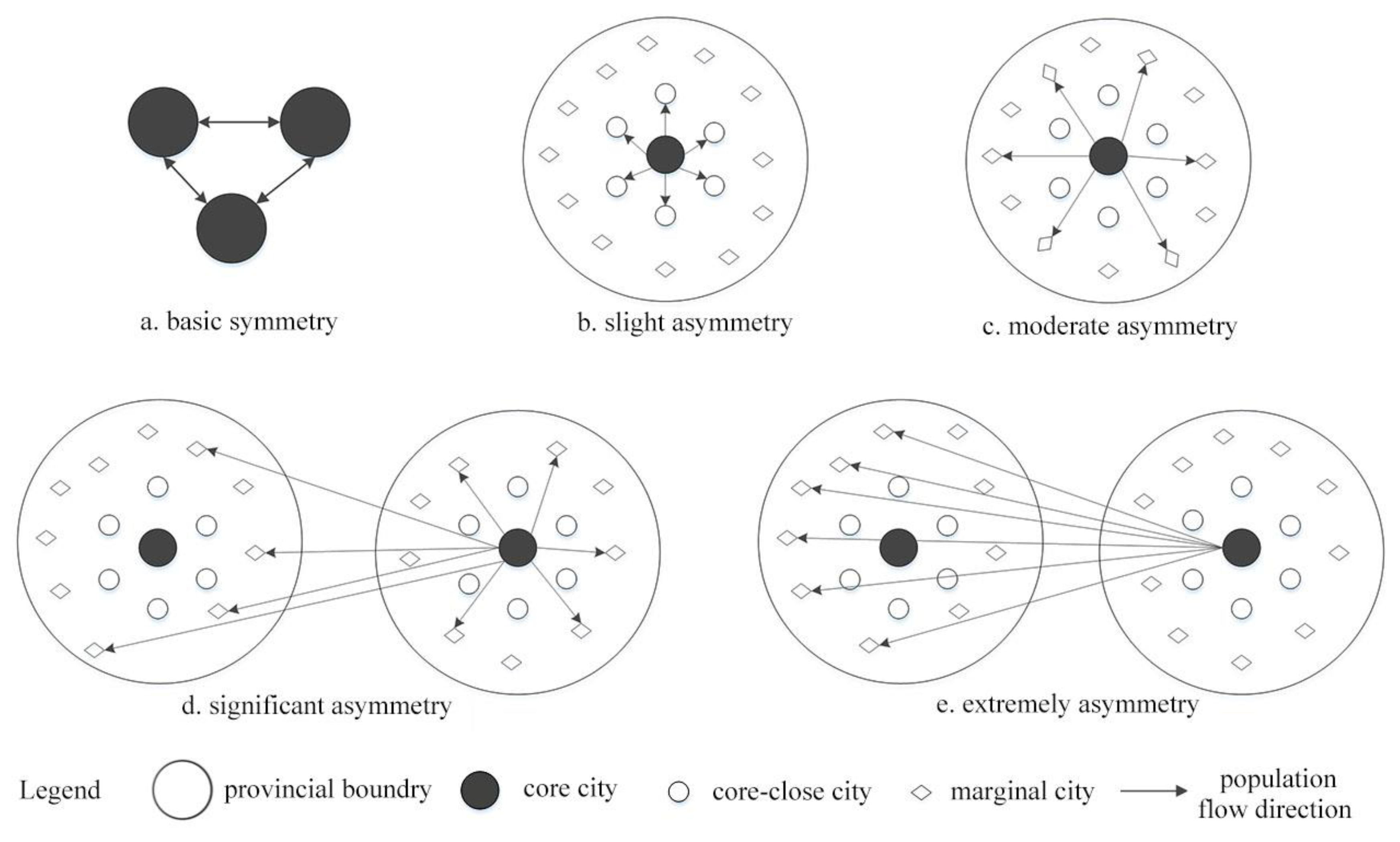
3.3.2. Network Symmetry

The connection of nodes can be expressed by the equilibrium change of the interaction between nodes. These interactions include two aspects, namely, strength and direction, and the direction can be expressed by symmetry [88]. In order to quantify asymmetry, Narisra Limtanakool [89] put forward the concepts of node symmetry, node influence, and link symmetry, and calculated the index formula.
(1) Node Symmetry Index. This is used to describe the asymmetry of population inflow and outflow in single nodes. For node i ,
N S I i = I i O i I i + O i
where I i refers to the indegree of node i ; O i refers to the outdegree of the node i . When N S I i = −1, it is the net outflow for node i ; when N S I i = 1, it is the net inflow for node i .
(2) Link Symmetry Index. It is used to judge the asymmetry level of population mobility between any two cities, for link i ,
L S I i j = ( f i j ) L n ( f i j ) + ( f j i ) L n ( f j i ) L n ( 2 )
where f i j refers to the ratio of the flow from node i to node j to the flow between node i and node j ; f j i refers to the ratio of the flow from node j to node i to the flow between node i and node j ; when L S I i j = 0, the link between node i and node j is unidirectional, that is, completely asymmetric, and when L S I i j = 1, the link between node i and node j is an equivalent bidirectional flow, that is, completely symmetrical.
It should be pointed out that, in the deduction of the formula L S I i j , it was found that the index itself did not have directionality, and there were certain limitations to the measurement of the difference of two-way flow. When T i j / T j i > 0.5 , L S I i j > 0.9 , that is, the logarithmic calculation in Formula (3), it makes the formula unable to more accurately describe the quantitative difference between two-way flows, but instead describes the difference in flow in the two directions in the same link [90]. Therefore, in order to solve the intuitive quantitative measurement of the symmetry of the two-way flow in the link and to distinguish the directionality of the link while judging the asymmetry level of the link, this paper complements Formula (3). When the difference of flow in the two directions in the link belongs to a non-order of magnitude difference,
L S Γ i j = T i j T j i T i j + T j i
where L S Γ i j is the modified link symmetry L S I i j , T i j is the flow from node i to node j , and T i j is the flow from node i to node j . Furthermore, if the variable concept in Formula (3) is replaced with that in Formula (4), Formula (4) can be simplified as
L S Γ i j = 2 f i j 1
where f i j refers to the ratio of the flow from node i to node j to the flow between node i and node j ; when L S Γ i j < 0 , the flow from node i to node j is smaller than that from node j to node i , and when L S Γ i j = 1 , it flows from node j to node i ; when L S Γ i j = 0 , there is a two-way equivalent flow in the link; when L S Γ i j > 0 , the flow from node i to node j is greater than that from node j to node i , and when L S Γ i j = 1 , it is the net flow from node i to node j .

4. Results

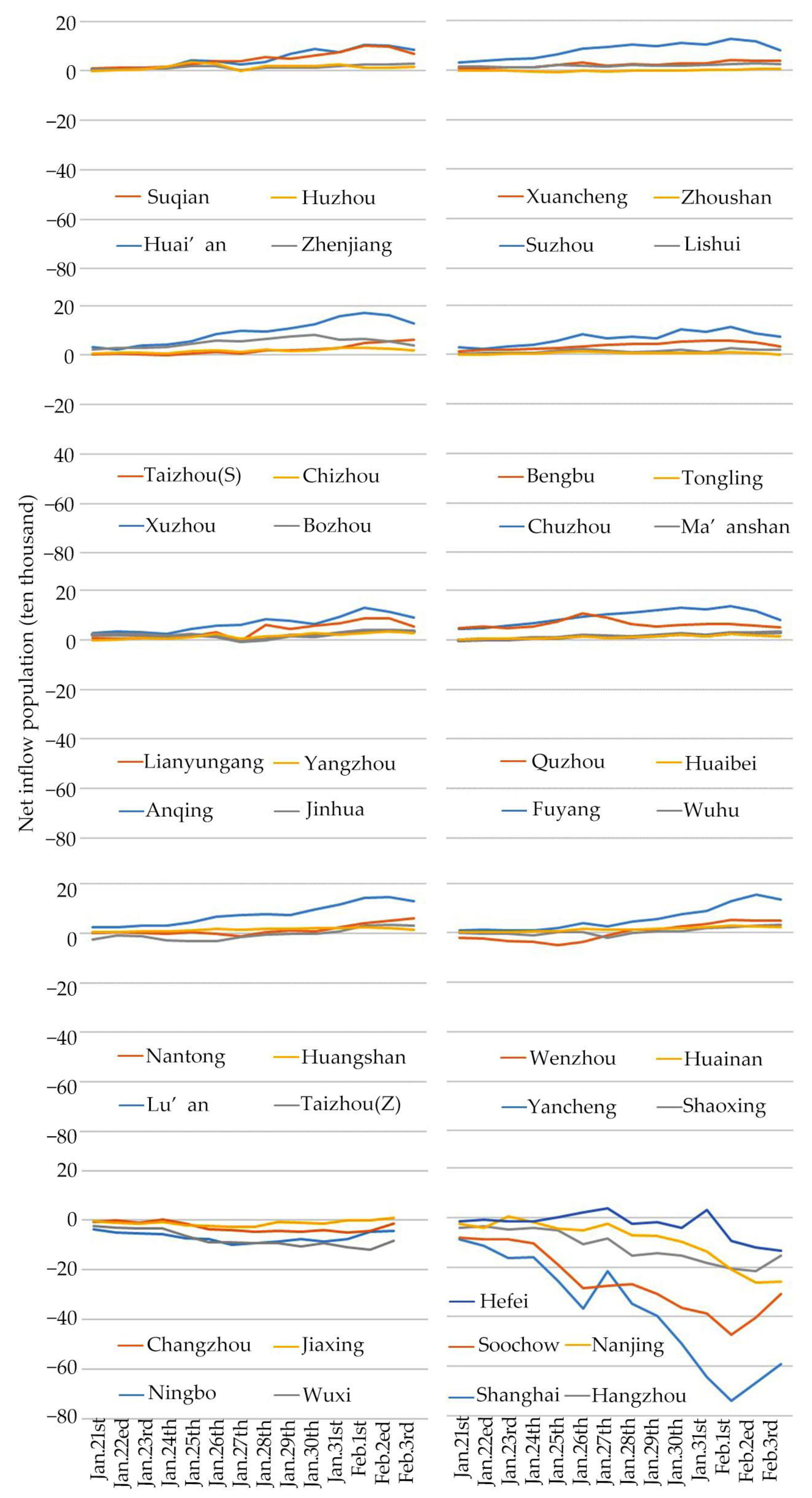
4.1. Temporal Asymmetric Population Mobility

The net population inflow scale of the cities in the YRD before the SF shows the characteristics of regular changes with the time series. Figure 4 shows the characteristics of the scale of population flow with the change of date. A positive value indicates that the city has a net population inflow, while a negative value indicates a net population outflow. It can be seen from Figure 4 that some cities, such as Shanghai, Nanjing, Soochow, Hangzhou, Hefei, and Wuxi, have a negative net inflow and a population outflow. Other cities, such as Fuyang, Lu’an, Xuzhou, Yancheng, and Suzhou, have a net inflow scale that is positive and an inflow population. Both types of cities show that the closer to the SF (New Year’s Eve’s reunion day falls on 4 February), the greater the intensity and scale of population mobility. After the “small peak” flow appeared on 26 January (“Xiaonian” day falls on 28 January), the scale of population mobility obviously increased and reached a “big peak” on 1 and 2 February, reflecting the temporal asymmetric population mobility feature.
The reason for the emergence of the “small peak” is, first of all, according to Chinese tradition, the SF begins with the date of “Xiaonian”; this day means people should begin to clean their houses and prepare food and goods for the SF. Secondly, in some areas of the YRD, there are still sacrificial activities, during which migrants who go out to do business, work, and study will go home to participate, so some employers will also begin to have a holiday before this day. However, not everyone can go home before this day, so there is a significant increase in the scale of population mobility and a “big peak” phenomenon. The reason is that compared with the “Xiaonian” day, on the traditional Chinese New Year’s Eve, families or relatives and friends get together to worship their ancestors and have a reunion dinner, so migrants return to their hometown before this day. The temporal asymmetry is consistent with our empirical judgment.

4.2. Spatial Asymmetry of Population Mobility

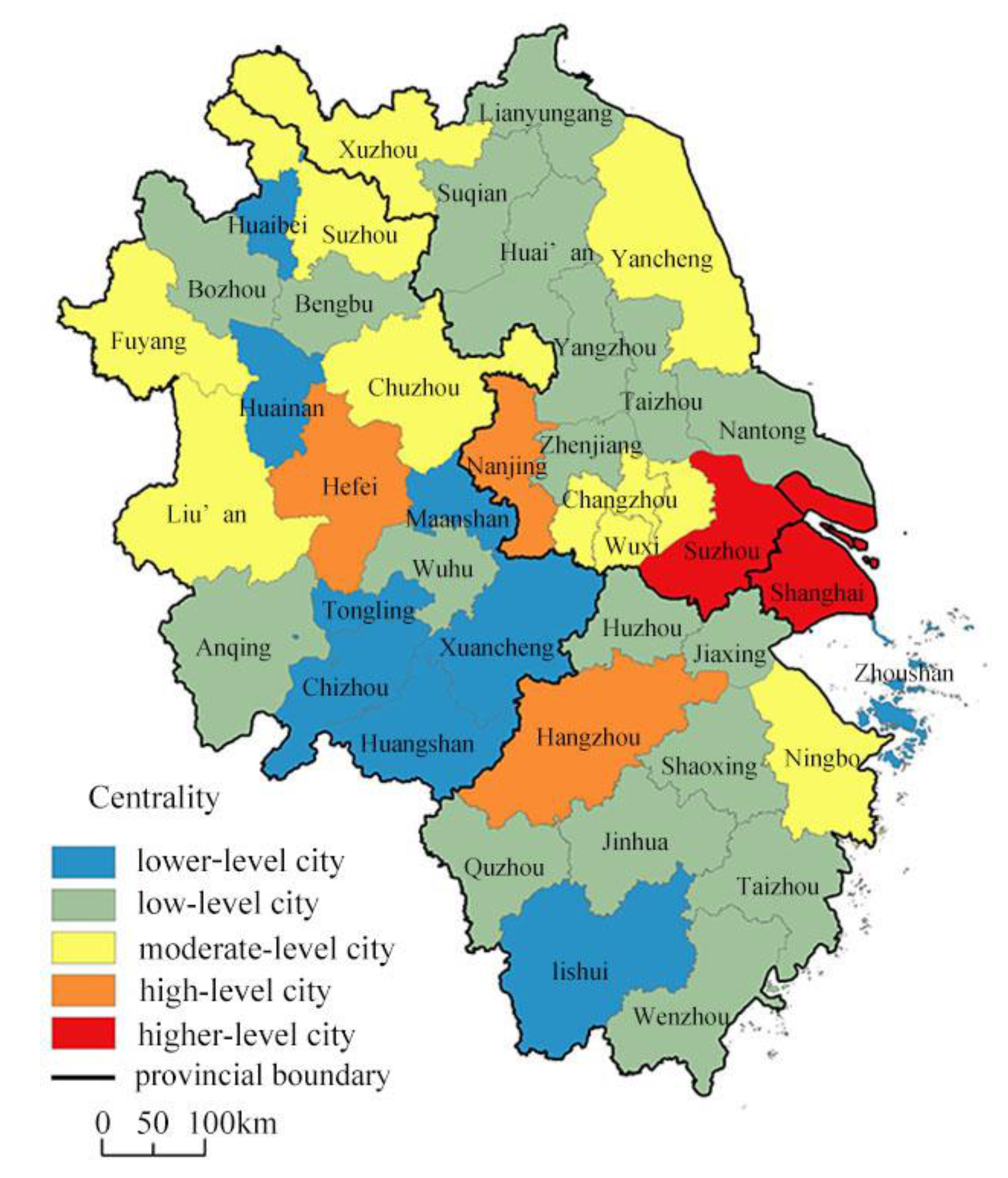
4.2.1. Preliminary Judgement of Spatial Asymmetry

The scale of net population inflow in the YRD shows obvious fluctuations and differences amongst cities (Figure 5). Firstly, there is the city difference between net population outflow and net inflow. Some cities have a net population outflow during the whole SF period, while some have a net population inflow. Meanwhile, others, such as Shaoxing, Taizhou, Wenzhou, and Zhoushan, are characterized by “first out and then in”, that is, the net outflow first and then net inflow. Secondly, there is the city difference in flow intensity. Compared with Changzhou and Jiaxing, the city, Shanghai, Suzhou, and others with net population outflow have a higher intensity of population mobility. As for the net inflow cities, the flow intensity of Huaibei, Huainan, Huangshan, Lu’an, Suzhou, Yancheng, and other cities is also quite different. These two differences reflect the imbalance and asymmetric characteristics of population mobility among cities, and we preliminarily assessed the spatial asymmetric pattern of population mobility during the SF.

4.2.2. Network Asymmetry

The degree of centrality reflects the importance of the city in the region. Through this measurement index, the characteristics of the population mobility network in the YRD were analyzed, and the centrality of population mobility was classified based on ArcGIS’s natural breaks method. The results show that (Figure 6) Shanghai, Soochow, Nanjing, Hangzhou, and Hefei are located in higher and high central-grade areas, indicating that these cities are closely connected to other cities, and even dominate the regional population network. Changzhou, Wuxi, Ningbo, Yancheng, Chuzhou, Suzhou, Xuzhou, Lu’an, and Fuyang are located in the northern peripheral of the region, belonging to the middle central-grade areas, which have weak linkages with other cities. The remaining cities are located on the east and west peripheries of the region and belong to low and lower central-grade areas, with weak linkages with other cities. Among the cities with a high center of population mobility network, Shanghai is the municipality directly under the Central Government; Nanjing, Hefei, and Hangzhou are provincial capitals, and Suzhou is the deputy central city in Jiangsu Province. These cities are regional functional central cities and are high in the administrative hierarchy. In other words, the population mobility network during the SF still shows the obvious characteristics of the administrative hierarchy. Therefore, we questioned whether the population mobility network would manifest some kinds of asymmetry features related to the administrative hierarchy, as in the core–periphery structure.
The degree of centrality reflects the centrality of a city through its connections with the total amount of other nodes and the intensity of the connection. Therefore, a city with high network centrality does not mean that it is the core city of the network because there may be a situation in which a city is only associated with a small number of other cities but with a greater connection intensity, or a city has connections with many other cities but weak connection intensity. The regional core cities in the network structure indicate a close relationship between these core cities and non-core (marginal) cities, but there is little or no relationship between the non-core cities.
Therefore, the core nodes of the population mobility network in the YRD were identified by the core–periphery structure analysis method. The results show that Shanghai, Nanjing, Soochow, Wuxi, Changzhou, Hangzhou, Ningbo, Jiaxing, and Hefei were the core cities, and the others were marginal cities (Table 1). A total of 21.95% of population mobility occurs between these core cities; 76.75% occurs between core–marginal cities, while only 1.30% between marginal cities (Table 2). That is, these nine core cities dominate 98.70% of the population mobility, indicating that people’s destinations are the core cities. Among these nine core cities, there were five cities with high centrality as well as a significant administrative hierarchy. In addition, Wuxi is a sub-central city of Jiangsu Province and Ningbo is a sub-provincial city, which is also high in the administrative hierarchy. Although Jiaxing and Changzhou are general prefecture-level cities, their economic levels are relatively high. Generally speaking, the population mobility in the YRD during the SF has asymmetrical characteristics in the administrative and economic dimensions, especially the administrative one.

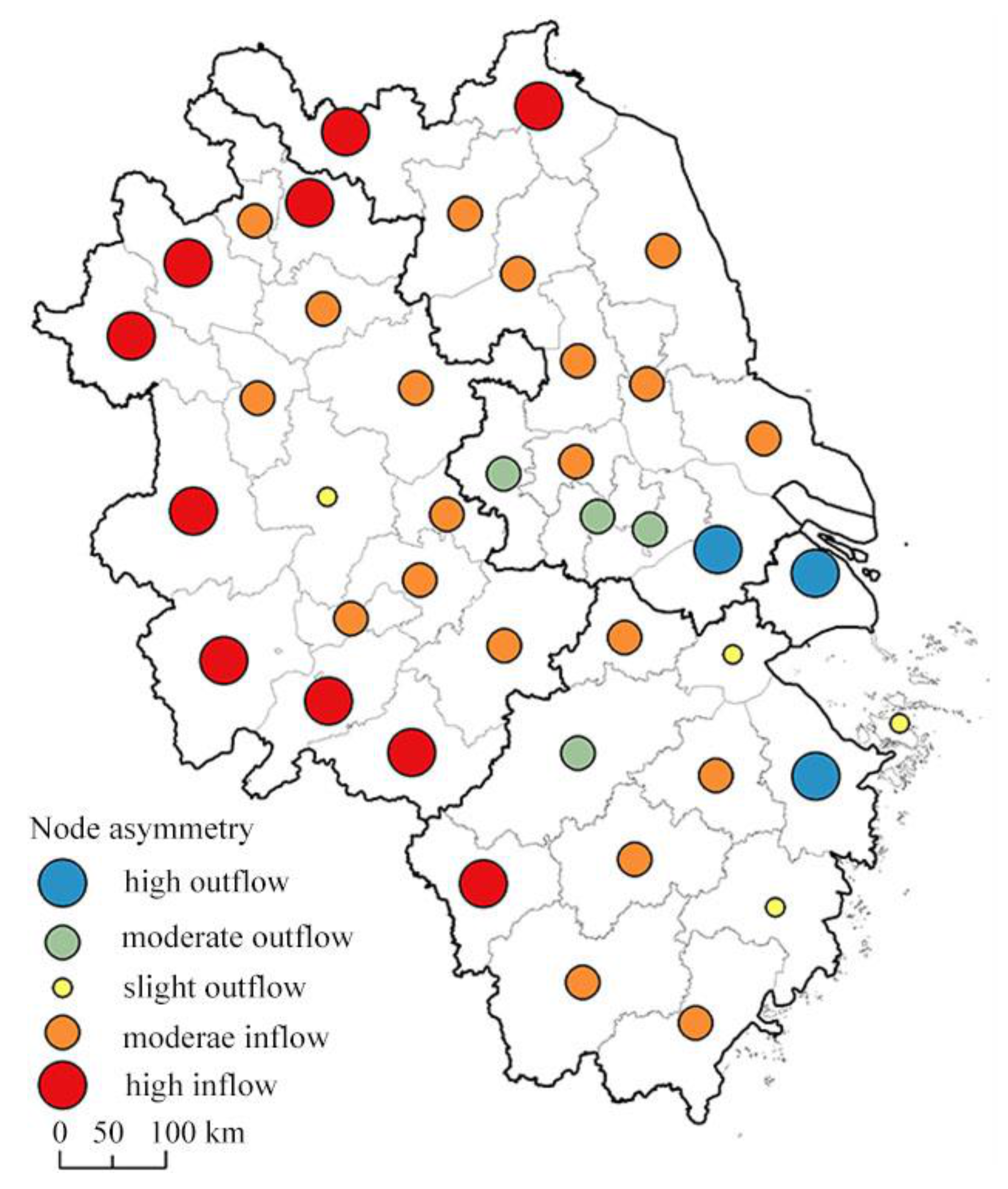
4.2.3. Node Asymmetry

The symmetry characteristics of population inflow and outflow in a single city were analyzed through node symmetry, and we conducted spatial visualization (Figure 7). According to the natural breaks, the symmetric population mobility can be divided into five types: high, moderate, and slight net population outflow, and moderate and high net population inflow. The results show that the nine core cities were all cities with net population outflow. In addition, among the marginal cities, only Taizhou and Zhoushan were slightly net population outflow cities, while the others were all net population inflow cities. The core–close cities mainly had moderate net population inflow, while the remote peripheral cities in the north and west had high net inflow. Generally speaking, the node asymmetry was manifested as an asymmetric population inflow and outflow between the core and marginal cities, with a significant net outflow in the core cities and a net inflow in the marginal cities.
The node asymmetry of net population inflow and outflow was that of one city for other cities overall, and it could not reflect the population mobility direction and asymmetry between any two cities. Whether there is symmetrical two-way population mobility or asymmetrical one-way population mobility between any two cities can be further explained by the analysis of link symmetry.

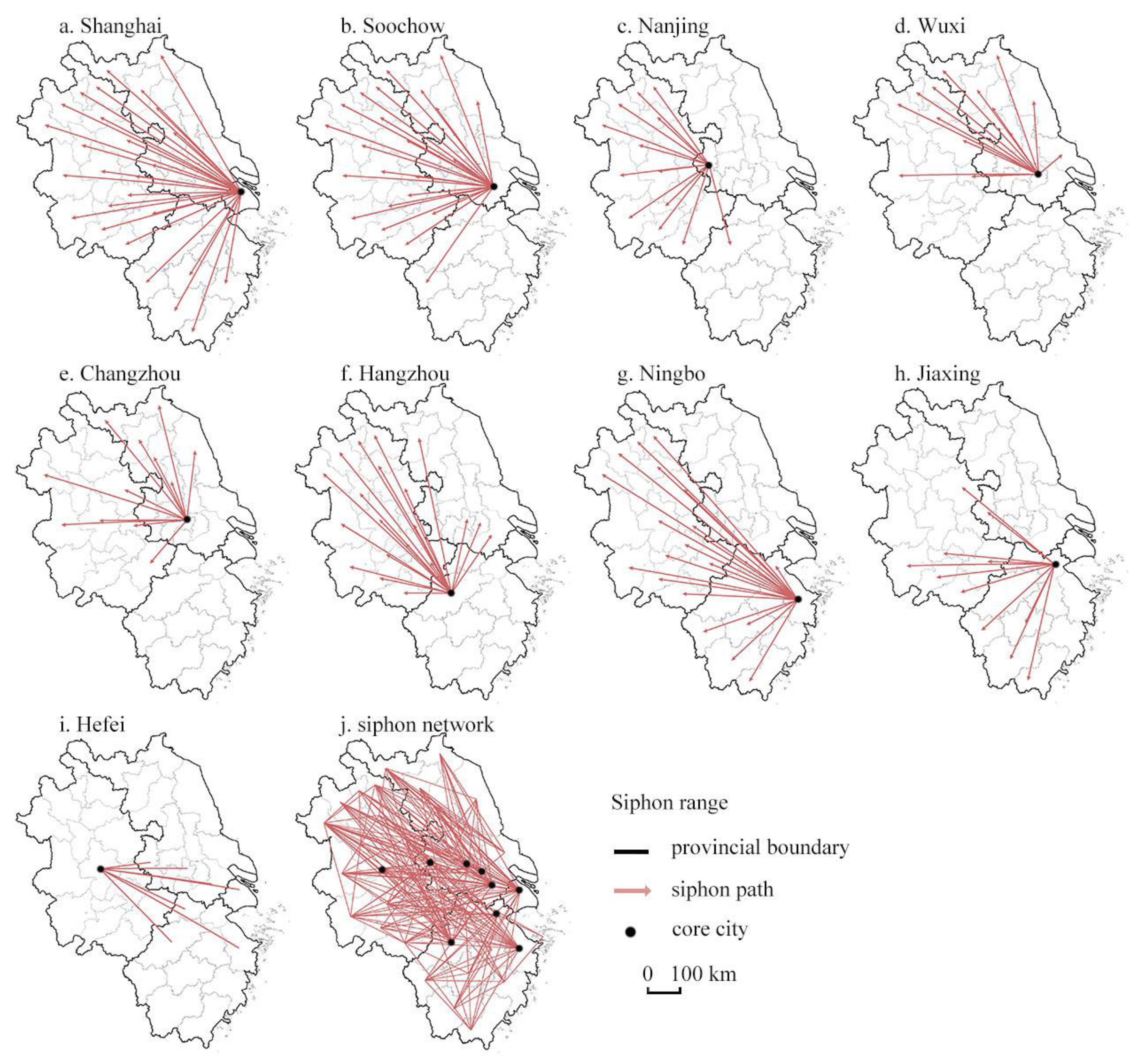
4.2.4. Link Asymmetry

We analyzed the direction and heterogeneity of intercity population mobility by link symmetry, and then revealed the asymmetric relationship between two cities. Referring to the natural breaks method, we took the view that a link symmetry value of less than 0.11 is the basic symmetrical linkage of population mobility, 0.12–0.28 is a slight asymmetric linkage, 0.29–0.53 is a moderate asymmetric linkage, 0.54–0.85 is a significant asymmetric linkage, and more than 0.85 is an extremely asymmetric linkage (Figure 8).
The results show that, firstly, the basic symmetrical linkages mainly occurred in the core cities and their surrounding cities, showing obvious distance proximity characteristics, forming a triangular nested structure. In addition, the northern marginal cities also showed basic symmetrical features, forming a spatial structure of axis linkage. The basic symmetrical linkage mainly occurred between cities in the same province. Secondly, both slight and moderate asymmetric linkages initially showed a radial connection structure centered on the core city, and the distance between cities was longer than that between basic symmetric links, but there were still obvious intra-provincial characteristics. Thirdly, the significant asymmetric linkages were mainly distributed in Shanghai, Jiangsu, and Anhui provinces, showing obvious asymmetric characteristics, forming a radial connection structure centered on the core cities Shanghai, Nanjing, and Soochow, with a long connection distance and obvious inter-provincial characteristics. Finally, extremely asymmetric linkages were distributed throughout the study area, showing a complex multi-layer radial nested structure, which is basically a long-distance connection between core and peripheral cities.
Whether a symmetrical or asymmetrical connecton, the core cities play a role to varying degrees, and they play an obvious leading role in the significant and extremely asymmetric linkages in particular. Therefore, we further analyzed these two kinds of asymmetry in order to clarify the asymmetrical role of the core cities. Due to the “reverse” characteristics of population migration before the SF, we defined the extreme and significant asymmetry from the core city to the marginal city as siphon and the reverse as radiation (Figure 9).
The results show that only Hefei, among the nine core cities, had population radiation, and the other core cities had population siphon. Whether siphon or radiation, the action area showed different fan-shaped effects, with significant provincial asymmetry characteristics. The siphon area of Shanghai is spread over the other three provinces, indicating that Shanghai’s floating population significantly stems from most of the cities in the YRD, which is consistent with Shanghai’s administrative status, economic level, and social functions in the YRD. The population siphon range of the four core cities in Jiangsu province mainly lies in Jiangsu and Anhui provinces. Nanjing’s high net population comes mostly from cities in Anhui, Soochow from northern Jiangsu and Anhui, Wuxi from some cities in northern Jiangsu and northern Anhui, and Changzhou from some cities in northern Jiangsu and central Anhui. The population siphon range of the three core cities in Zhejiang province is mainly in Anhui and Zhejiang provinces. Hangzhou’s net population comes from Anhui province and “Su-Xi-Chang” city, Ningbo from Anhui and southern Zhejiang, and Jiaxing from southern Anhui and southern Zhejiang. The only population radiation city, Hefei, has a high net population loss to other core cities, which partly explains Hefei’s limited population attractiveness. In general, such provincial asymmetry is prominently reflected in the specific population siphon and radiation range of the intra-provincial or inter-provincial of the core cities. In particular, the cities in Anhui province, including the core city Hefei, are characterized by significantly high net population loss. In addition, there is no significant population siphon or radiation phenomenon between Jiangsu and Zhejiang provinces.
We generalized the diagram of spatial asymmetric population mobility patterns during the SF (Figure 10), which reflect what types of cities these asymmetric patterns occur between, core cities or core and peripheral (core–close and marginal) cities.

5. Discussion

Based on the migration big data during the SF travel season (before the SF), we conducted a systematic analysis of the asymmetrical spatiotemporal patterns of population mobility in the YRD. The time series asymmetric population mobility is mainly manifested by the scale of flow. The closer it is to Chinese New Year’s Eve, the larger the scale, and the peak of the scale of population mobility falls on 26 January and 2 February, two days before “Xiaonian” day (28 January) and New Year’s Eve (4 February). This is consistent with our empirical judgment, and it is also the same time as the peak of population mobility during the SF on a national scale [91]. Our conclusions provide a comparative basis for exploring the differential performance and influence mechanisms of the temporal characteristics of population migration during the SF travel season at different scales.
The spatial asymmetry of population mobility is mainly reflected in three dimensions—network, node, and link. There is a significant core–periphery structure of population mobility in the regional network aspect. These core cities are cities with high administrative and economic levels, and more than 90% of the population mobility is dominated by them, showing obvious characteristics of high-level urban agglomeration. Although we did not take administrative hierarchy or economic position into account in the analysis process, as it did not seem strictly necessary to “control” for these attributes, they are very important in a theoretical sense. It is quite reasonable to expect migration flows to correspond to either, or both, administrative hierarchy and economic status. For example, from massive urban centers such as Shanghai, Nanjing, Hangzhou, and Soochow, we expected, and the results prove (Figure 8, the siphon range of the population), that there would be a large number of immigrants in such a place, and the geographical scope of that migration would be larger than that of smaller cities.
At the node level, there was a significant net population outflow in the core cities and a net population inflow in the peripheral cities. Moreover, periphery cities close to the core ones have a small degree of asymmetry, while the remote marginal cities have a large degree of asymmetry. In other words, distance has an important influence on the degree of asymmetry of population mobility, which is reflected in the law that the degree of asymmetry increases with the increase in distance, called the distance enhancement effect. Distance was also not a strict “control” variable in the analysis process, but, similarly, the results show that it has a role that cannot be ignored. Although there are differences in the geographical scope of migration between large cities and small cities, the radiation range of their urban center has the effect of distance attenuation, which means that the urban center has a stronger radiation capacity affecting its neighboring cities. Long distance also means an increase in moving costs, including explicit costs, such as mobility time and transportation costs, and hidden costs, such as information, psychology, and social relations [92]. Therefore, people are more inclined to move between geographically adjacent cities.
However, at the linkage level, population mobility with a small degree of asymmetry mainly occurs between the core cities and the intra-provincial peripheral cities, while population mobility with large asymmetries is mainly reflected in the population siphon of the core cities to the inter-province remote marginal cities. In the two groups of cities with similar distances, the degree of asymmetry of population mobility within the same province is less than that of inter-provincial population mobility. To a certain extent, this shows that provincial administrative boundary has a blocking effect on asymmetry. It seems not difficult to understand that there are high similarities in systems and policies among cities in the same province. For example, with the existence of the household registration system, intra-provincial immigrants face relatively less discrimination than inter-provincial immigrants in terms of employment, housing, public services, and social welfare [93,94].
The blocking effect of administrative boundaries on the geographical scope of immigration reflects the “local” characteristics. However, with the further development of the integration of the YRD and the construction of the metropolitan areas of Shanghai, Nanjing, Hangzhou, Ningbo, and “Su-Xi-Chang”, the population will continue to be concentrated in the mega-cities and metropolitan areas, which will strengthen the asymmetric pattern of population mobility to a great extent. What many scholars, ourselves included, are concerned about and discussing is whether this asymmetric population mobility pattern is a sustainable development with a balanced trend since it is undeniable that asymmetry reflects a state of “spatial imbalance”. However, some scholars have proposed that it is the asymmetric population flow that guarantees the equalization trend of a region because cities with administrative and economic advantages, by carrying a larger population, achieve the “socio-economic equalization” of per capita indicators [95]. Thus, from this perspective, with the further asymmetric flow and concentration of population to large cities and urban regions, the urbanization rate in the near future will show a trend of rapid growth in large cities and slow growth in smaller cities. The urbanization levels of large and small cities maintain a relatively stable gap, stabilizing at a certain level for a certain period in the future.
This paper also has some limitations. We only set the traditional holiday period of the SF as the research period. However, as mentioned at the beginning of the paper, the SF travel season is unique and representative, and can reflect China’s social development and changes in the past 40 years. Regardless, there are other traditional festivals in China, such as the Lantern Festival, the Ching Ming Festival, the Dragon Boat Festival, and the Mid-Autumn Festival, and large-scale population flows also occur for these holidays. Although we have not conducted a detailed analysis of population flow during these holidays, it can be inferred from the customs and rural complex of Chinese people returning to their hometown on traditional holidays that the possible pattern of population migration during these holidays may be similar to that of the SF travel season. Due to a similar core–periphery structure and population flow directions, there will be more population inflow/outflow between regional core cities and large cities compared to smaller cities.
The data have a bias in the collection of groups and do not include the socio-economic attributes of migrant individuals; however, it should be recognized that migration big data have advantages in population mobility research. There is a large sample size and a data source that conforms to the characteristics of the information age, which can comprehensively and reflect in real-time the migration status of human beings and the connections between areas [45,96]. We applied the complex network method, a method with outstanding advantages in the research of the centrality and directionality of population flow connections, which is an effective attempt to explore the application potential of migrating big data. Future research will increase the discussion and strict “control” on socio-economic attributes in order to look forward to a more detailed and microscopic understanding of the mechanism of population mobility patterns.

6. Conclusions

The large-scale complex passenger transportation during the SF is a unique phenomenon in the process of urbanization in China. Analyzing and describing the characteristics of population mobility during the SF can reveal the results of population mobility and migration and reflect the recent trend of urbanization. We first constructed an asymmetrical analysis framework of population mobility and selected the YRD region as a case, where the level of urbanization and dense intercity connections are typical of China. Based on Tencent migration big data, complex network analysis methods were used to reveal the asymmetric performance and patterns of population mobility from temporal and spatial aspects.
The asymmetry of the time series was manifested in that the closer it was to New Year’s Eve, the larger the scale of population flow. This characteristic in the YRD is also similar to that of other regions of China, and even the whole of China. In other words, the time series asymmetry of population movement during the Chinese SF has the characteristics of no scale and no regional difference. The asymmetry of the spatial network is dominated by a few core cities with administrative and economic comparative advantages with a higher population net inflow, and is concentrated in these core cities as they can absorb more people and attract a larger geographical scope of migrants. To a certain extent, this indicates that the “core–periphery” asymmetric population mobility structure based on “space of flow” cannot escape the “rank-size” feature of “space of place”. This asymmetrical pattern of population spatial flow is, in fact, a manifestation of the differences in the development of large cities and small cities and urban and rural areas in the region. Moreover, the degree of asymmetry of population mobility increases with the increase in the distance from the core cities, that is, the distance enhancement effect, which is the most intuitive geospatial expression of asymmetry, and is also proof of the distance attenuation of the core cities’ radiation capacity. In addition, the provincial administrative boundary has a blocking effect on population movement, that is, it strengthens the degree of asymmetry.
Hierarchy, distance, and administrative boundaries are three important factors that affect the asymmetric performance and pattern of population mobility. These factors cannot be ignored in future understandings of the spatial patterns of population mobility. City managers and policymakers should realize that population migration can promote the optimal coordination of labor and other socio-economic factors, thereby promoting regional socio-economic integration. This is essential for realizing the goal of achieving high-quality integrated development in the YRD. We hope that the conclusions of this paper provide reference values to achieve effective regional management and rational allocation of resources based on the law of population migration and the spatial distribution patterns of a floating population.

Author Contributions

Conceptualization, Jinping Lin and Shan Yang; methodology, Jinping Lin; formal analysis, Jinping Lin; resources, Jinping Lin; data curation, Jinping Lin; writing—original draft preparation, Jinping Lin, Kangmin Wu and Qianqian Liu; project administration, Shan Yang; funding acquisition, Shan Yang. All authors have read and agreed to the published version of the manuscript.

Funding

This research was funded by the National Natural Science Foundation of China (No. 41771171; No. 42171200).

Data Availability Statement

Data sharing not applicable. The original population migration data during the Spring Festival can be obtained from Tencent’s location big data platform https://heat.qq.com/qianxi.php.

Conflicts of Interest

The authors declare no conflict of interest.

References

  1. Zhang, K.H.; Song, S. Rural–urban migration and urbanization in China: Evidence from time-series and cross-section analyses. China Econ. Rev. 2003, 14, 386–400. [Google Scholar] [CrossRef]
  2. Feng, J.; Wang, F.; Zhou, Y. The Spatial Restructuring of Population in Metropolitan Beijing: Toward Polycentricity in the Post-Reform ERA. Urban Geogr. 2009, 30, 779–802. [Google Scholar] [CrossRef]
  3. Liu, T.; Qi, Y.; Cao, G.; Liu, H. Spatial patterns, driving forces, and urbanization effects of China’s internal migration: County-level analysis based on the 2000 and 2010 censuses. J. Geogr. Sci. 2015, 25, 236–256. [Google Scholar] [CrossRef]
  4. Cui, C.; Wu, X.; Liu, L.; Zhang, W. The spatial-temporal dynamics of daily intercity mobility in the Yangtze River Delta: An analysis using big data. Habitat Int. 2020, 106, 102174. [Google Scholar] [CrossRef]
  5. Chan, K.W.; Zhang, L. The Hukou System and Rural-Urban Migration in China: Processes and Changes. China Q. 1999, 160, 818–855. [Google Scholar] [CrossRef] [Green Version]
  6. Wei, Y.; Song, W.; Xiu, C.; Zhao, Z. The rich-club phenomenon of China’s population flow network during the country’s spring festival. Appl. Geogr. 2018, 96, 77–85. [Google Scholar] [CrossRef]
  7. Shen, J. Changing Patterns and Determinants of Interprovincial Migration in China 1985–2000. Popul. Space Place 2011, 18, 384–402. [Google Scholar] [CrossRef]
  8. Friedrichs, C.R. Capitalism, mobility and class formation in the early modern german city. Past Present. 1975, 69, 24–48. [Google Scholar] [CrossRef]
  9. Walker, R.A. Putting capital in its place: Globalization and the prospects for labor. Geoforum 1999, 30, 263–284. [Google Scholar] [CrossRef]
  10. Smith, N. Uneven Development: Nature, Capital, and the Production of Space, 3rd ed.; University of Georgia Press: London, UK, 2008. [Google Scholar]
  11. Fan, J.; Tao, A.; Lv, C. The coupling mechanism of the centroids of economic gravity and population gravity and its effect on the regional gap in China. Prog. Geogr. 2010, 29, 87–95. [Google Scholar] [CrossRef]
  12. Ye, C.; Chen, M.; Duan, J.; Yang, D. Uneven development, urbanization and production of space in the middle-scale region based on the case of Jiangsu province, China. Habitat Int. 2017, 66, 106–116. [Google Scholar] [CrossRef]
  13. Braun, S.T.; Weber, H. How do regional labor markets adjust to immigration? A dynamic analysis for post-war Germany. J. Int. Econ. 2021, 129, 103416. [Google Scholar] [CrossRef]
  14. Bosker, M.; Brakman, S.; Garretsen, H.; Schramm, M. Relaxing Hukou: Increased labor mobility and China’s economic geography. J. Urban Econ. 2012, 72, 252–266. [Google Scholar] [CrossRef] [Green Version]
  15. Fu, Y.; Gabriel, S.A. Labor migration, human capital agglomeration and regional development in China. Reg. Sci. Urban Econ. 2012, 42, 473–484. [Google Scholar] [CrossRef]
  16. Su, F.; Tao, R. The China model withering? Institutional roots of China’s local developmentalism. Urban Stud. 2016, 54, 230–250. [Google Scholar] [CrossRef]
  17. Wei, Y.D.; Wu, Y.; Liao, F.H.; Zhang, L. Regional inequality, spatial polarization and place mobility in provincial China: A case study of Jiangsu province. Appl. Geogr. 2020, 124, 102296. [Google Scholar] [CrossRef]
  18. Taylor, P.J.; Derudder, B. World City Network: A Global Urban Analysis, 2nd ed.; Routledge: London, UK, 2015. [Google Scholar]
  19. Berry, B.J.L. Cities as systems within systems of cities. Pap. Reg. Sci. 1964, 13, 146–163. [Google Scholar] [CrossRef]
  20. Knox, P.L. World Cities in a World-System; Knox, P.L., Taylor, P.J., Eds.; Cambridge University Press: Cambridge, UK, 1995. [Google Scholar]
  21. Sigler, T.J.; Martinus, K. Extending beyond ‘world cities’ in World City Network (WCN) research: Urban positionality and economic linkages through the Australia-based corporate network. Environ. Plan. A Econ. Space 2016, 49, 2916–2937. [Google Scholar] [CrossRef]
  22. Castells, M. The Space of Flows: A Theory Space in the Informational Society; Princeton University: Princeton, NJ, USA, 1992. [Google Scholar]
  23. Castells, M. Grassrooting the space of flows. Urban Geogr. 1999, 20, 294–302. [Google Scholar] [CrossRef]
  24. Pflieger, G.; Rozenblat, C. Introduction. Urban Networks and Network Theory: The City as the Connector of Multiple Networks. Urban Stud. 2010, 47, 2723–2735. [Google Scholar] [CrossRef] [Green Version]
  25. Xi, G.; Zhen, F.; Chang, E. Measuring Urban Space of Flows in Information Era: Empirical Evidence from Nanjing, China. Int. Rev. Spat. Plan. Sustain. Dev. 2016, 4, 42–57. [Google Scholar] [CrossRef] [Green Version]
  26. Castells, M. The Rise of the Network Society; Oxford Blackwell Publishers: Cambridge, UK, 1996. [Google Scholar]
  27. Taylor, P.J.; Hoyler, M.; Verbruggen, R. External Urban Relational Process: Introducing Central Flow Theory to Complement Central Place Theory. Urban Stud. 2010, 47, 2803–2818. [Google Scholar] [CrossRef] [Green Version]
  28. Neal, Z.P. From Central Places to Network Bases: A Transition in the U.S. Urban Hierarchy, 1900–2000. City Commun. 2011, 10, 49–75. [Google Scholar] [CrossRef]
  29. Xu, F.; Zhen, F.; Qin, X.; Wang, X.; Wang, F. From central place to central flow theory: An exploration of urban catering. Tour. Geogr. 2018, 21, 121–142. [Google Scholar] [CrossRef]
  30. Krätke, S. Global Pharmaceutical and Biotechnology Firms’ Linkages in the World City Network. Urban Stud. 2013, 51, 1196–1213. [Google Scholar] [CrossRef]
  31. Smith, D.A.; Timberlake, M.F. World City Networks and Hierarchies, 1977–1997. Am. Behav. Sci. 2001, 44, 1656–1678. [Google Scholar] [CrossRef]
  32. Taylor, P.J. Leading World Cities: Empirical Evaluations of Urban Nodes in Multiple Networks. Urban Stud. 2005, 42, 1593–1608. [Google Scholar] [CrossRef]
  33. Friedmann, J. The World City Hypothesis. Dev. Chang. 1986, 17, 69–83. [Google Scholar] [CrossRef]
  34. Batty, M.; Kim, K.S. Form Follows Function: Reformulating Urban Population Density Functions. Urban Stud. 1992, 29, 1043–1069. [Google Scholar] [CrossRef]
  35. Timberlake, M. The Polycentric Metropolis: Learning from Mega-City Regions in Europe. J. Am. Plan. Assoc. 2008, 74, 384–385. [Google Scholar] [CrossRef]
  36. Wei, Z.; Zhen, F.; Mo, H.; Wei, S.; Peng, D.; Zhang, Y. Travel Behaviours of Sharing Bicycles in the Central Urban Area Based on Geographically Weighted Regression: The Case of Guangzhou, China. Chin. Geogr. Sci. 2020, 31, 54–69. [Google Scholar] [CrossRef]
  37. Harvey, D. The Enigma of Capital and the Crisis of Capitalism. Estado Comunes Rev. Políticas Probl. Públicos 2013, 1. [Google Scholar] [CrossRef]
  38. Harvey, D. Retrospect on the Limits to Capital. Antipode 2004, 36, 544–549. [Google Scholar] [CrossRef]
  39. Ma, H.; Fang, C.; Lin, S.; Huang, X.; Xu, C. Hierarchy, clusters, and spatial differences in Chinese inter-city networks constructed by scientific collaborators. J. Geogr. Sci. 2018, 28, 1793–1809. [Google Scholar] [CrossRef]
  40. Dai, L.; Derudder, B.; Liu, X. The evolving structure of the Southeast Asian air transport network through the lens of complex networks, 1979–2012. J. Transp. Geogr. 2018, 68, 67–77. [Google Scholar] [CrossRef]
  41. Jacobs, W.; Koster, H.; Hall, P. The Location and Global Network Structure of Maritime Advanced Producer Services. Urban Stud. 2011, 48, 2749–2769. [Google Scholar] [CrossRef]
  42. Hou, H.; Liu, Y.; Liu, Y.; Wei, X.; He, Q.; He, Q. Using inter-town network analysis in city system planning: A case study of Hubei Province in China. Habitat Int. 2015, 49, 454–465. [Google Scholar] [CrossRef]
  43. Raffnsøe, S. The Rise of the Network Society: An Outline of the Dissertation Coexistence without Common Sense; MPP Working Paper; Department of Management, Politics and Philosophy, Copenhagen Business School: Copenhagen, Denmark, 2003; pp. 1–27. Available online: https://research.cbs.dk/en/publications/the-rise-of-the-network-society-an-outline-of-the-dissertation-ic (accessed on 29 June 2020).
  44. Hu, X.; Wang, C.; Wu, J.; Stanley, H.E. Understanding interurban networks from a multiplexity perspective. Cities 2020, 99, 102625. [Google Scholar] [CrossRef]
  45. Fuchs, M.; Höpken, W.; Lexhagen, M. Big data analytics for knowledge generation in tourism destinations—A case from Sweden. J. Destin. Mark. Manag. 2014, 3, 198–209. [Google Scholar] [CrossRef]
  46. Liu, W.; Hou, Q.; Xie, Z.; Mai, X. Urban Network and Regions in China: An Analysis of Daily Migration with Complex Networks Model. Sustainability 2020, 12, 3208. [Google Scholar] [CrossRef] [Green Version]
  47. Pan, J.; Lai, J. Spatial pattern of population mobility among cities in China: Case study of the National Day plus Mid-Autumn Festival based on Tencent migration data. Cities 2019, 94, 55–69. [Google Scholar] [CrossRef]
  48. Li, T.; Wang, J.; Huang, J.; Gao, X. Exploring temporal heterogeneity in an intercity travel network: A comparative study between weekdays and holidays in China. J. Geogr. Sci. 2020, 30, 1943–1962. [Google Scholar] [CrossRef]
  49. Lai, J.; Pan, J. China’s City Network Structural Characteristics Based on Population Flow during Spring Festival Travel Rush: Empirical Analysis of “Tencent Migration” Big Data. J. Urban Plan. Dev. 2020, 146, 04020018. [Google Scholar] [CrossRef]
  50. Wang, X.; Ding, S.; Cao, W.; Fan, D.; Tang, B. Research on Network Patterns and Influencing Factors of Population Flow and Migration in the Yangtze River Delta Urban Agglomeration, China. Sustainability 2020, 12, 6803. [Google Scholar] [CrossRef]
  51. Hao, P.; Tang, S. Migration destinations in the urban hierarchy in China: Evidence from Jiangsu. Popul. Space Place 2017, 24, e2083. [Google Scholar] [CrossRef]
  52. Whyte, M.K. One Country, Two Societies: Rural-Urban Inequality in Contemporary China; Harvard University Press: Cambridge, UK, 2010. [Google Scholar]
  53. Cao, Z.; Zheng, X.; Liu, Y.; Li, Y.; Chen, Y. Exploring the changing patterns of China’s migration and its determinants using census data of 2000 and 2010. Habitat Int. 2018, 82, 72–82. [Google Scholar] [CrossRef]
  54. Castles, S. Understanding Global Migration: A Social Transformation Perspective. J. Ethn. Migr. Stud. 2010, 36, 1565–1586. [Google Scholar] [CrossRef]
  55. Kincses, A.; Tóth, G. The geographical network of international migration. Environ. Plan. A Econ. Space 2020, 52, 1243–1245. [Google Scholar] [CrossRef]
  56. Mckenzie, D.; Rapoport, H. Network effects and the dynamics of migration and inequality: Theory and evidence from Mexico. J. Dev. Econ. 2007, 84, 1–24. [Google Scholar] [CrossRef] [Green Version]
  57. Abel, G.J.; Sander, N. Quantifying Global International Migration Flows. Science 2014, 343, 1520–1522. [Google Scholar] [CrossRef]
  58. Sanderson, M.R.; Witlox, F.; Derudder, B.; Timberlake, M. Are world cities also world immigrant cities? An international, cross-city analysis of global centrality and immigration. Int. J. Comp. Sociol. 2015, 56, 173–197. [Google Scholar] [CrossRef] [Green Version]
  59. Deutschmann, E. Regionalization and Globalization in Networks of Transnational Human Mobility, 2000–2010; (30 October 2015). 2000. Available online: https://ssrn.com/abstract=2638483 (accessed on 12 May 2021).
  60. Cao, G.; Li, M.; Ma, Y.; Tao, R. Self-employment and intention of permanent urban settlement: Evidence from a survey of migrants in China’s four major urbanising areas. Urban Stud. 2014, 52, 639–664. [Google Scholar] [CrossRef]
  61. Lee, K.-S.; You, S.Y.; Eom, J.K.; Song, J.; Min, J.H. Urban spatiotemporal analysis using mobile phone data: Case study of medium- and large-sized Korean cities. Habitat Int. 2018, 73, 6–15. [Google Scholar] [CrossRef]
  62. Yang, X. Symmetrical Distributions of Cities and Urbanization Trends in China. J. Geogr. Sci. 2012, 22, 382–383. Available online: http://www.geogsci.com/EN/Y2012/V22/I2/382 (accessed on 10 March 2021).
  63. Chen, Y.; Zhou, Y. Reinterpreting Central Place Networks Using Ideas from Fractals and Self-Organized Criticality. Environ. Plan. B Plan. Des. 2006, 33, 345–364. [Google Scholar] [CrossRef]
  64. Christaller, W.; Baskin, C.W. Central Places in Southern Germany; Translated by Baskin, C.W.; Englewood Cliffs: Prentice-Hall, NJ, USA, 1966; pp. 1–230. [Google Scholar]
  65. Taylor, P.J.; Hoyler, M. Lost in plain sight: Revealing central flow process in Christaller’s original central place systems. Reg. Stud. 2020, 55, 345–353. [Google Scholar] [CrossRef]
  66. Liu, C.-S. Maximal non-symmetric entropy leads naturally to zipf’s law. Fractals 2008, 16, 99–101. [Google Scholar] [CrossRef] [Green Version]
  67. Chen, Y. The distance-decay function of geographical gravity model: Power law or exponential law? Chaos Solitons Fractals 2015, 77, 174–189. [Google Scholar] [CrossRef] [Green Version]
  68. Wu, C.; Ye, X.; Du, Q.; Luo, P. Spatial effects of accessibility to parks on housing prices in Shenzhen, China. Habitat Int. 2017, 63, 45–54. [Google Scholar] [CrossRef]
  69. Oshan, T.M. The spatial structure debate in spatial interaction modeling: 50 years on. Prog. Hum. Geogr. 2020. [Google Scholar] [CrossRef]
  70. Griffith, D.A. Modeling spatial autocorrelation in spatial interaction data: Empirical evidence from 2002 Germany journey-to-work flows. J. Geogr. Syst. 2009, 11, 117–140. [Google Scholar] [CrossRef]
  71. Postiglione, P.; Hewings, G.J.D. Hierarchical spatial interaction among the Italian regions: A nonlinear relative dynamics approach. J. Geogr. Syst. 2008, 10, 369–382. [Google Scholar] [CrossRef]
  72. Lu, D. An analysis of spatial structure and optimal regional development. Acta Geogr. Sin. 2001, 56, 127–135. [Google Scholar] [CrossRef]
  73. Lu, D. Formation and dynamics of the “Pole-Axis” spatial system. Acta Geogr. Sin. 2002, 22, 1–6. [Google Scholar] [CrossRef]
  74. Zhou, Y. Major Directions of Economic Linkages: Some Theoretical Considerations. City Plan. Rev. 1998, 2, 22–25. Available online: http://en.cnki.com.cn/Article_en/CJFDTOTAL-CSGH802.006.htm (accessed on 1 July 2021).
  75. Weiss, D.J.; Nelson, A.; Gibson, H.; Temperley, W.; Peedell, S.; Lieber, A.; Hancher, M.; Poyart, E.; Belchior, S.; Fullman, N.; et al. A global map of travel time to cities to assess inequalities in accessibility in 2015. Nature 2018, 553, 333–336. [Google Scholar] [CrossRef]
  76. Barbosa, H.; Barthelemy, M.; Ghoshal, G.; James, C.R.; Lenormand, M.; Louail, T.; Menezes, R.; Ramasco, J.J.; Simini, F.; Tomasini, M. Human Mobility: Models and Applications. Phys. Rep. 2018, 734, 1–74. [Google Scholar] [CrossRef] [Green Version]
  77. Rodrigues, A.L.; Giannotti, M.; Barboza, M.H.C.; Alves, B.B. Measuring mobility inequalities of favela residents based on mobile phone data. Habitat Int. 2021, 110, 102346. [Google Scholar] [CrossRef]
  78. Wang, N.; Wang, H.; Du, Y.; Yi, J.; Liu, Z.; Tu, W. Population migration across the Qinghai-Tibet Plateau: Spatiotemporal patterns and driving factors. J. Geogr. Sci. 2021, 31, 195–214. [Google Scholar] [CrossRef]
  79. Zhou, S. Characterising and modelling the internet topology—The rich-club phenomenon and the PFP model. BT Technol. J. 2006, 24, 108–115. [Google Scholar] [CrossRef]
  80. Opsahl, T.; Colizza, V.; Panzarasa, P.; Ramasco, J.J. Prominence and Control: The Weighted Rich-Club Effect. Phys. Rev. Lett. 2008, 101, 168702. [Google Scholar] [CrossRef] [PubMed] [Green Version]
  81. Pigott, D.M.; Golding, N.; Mylne, A.; Huang, Z.; Weiss, D.J.; Brady, O.; Kraemer, M.U.G.; Hay, S. Mapping the zoonotic niche of Marburg virus disease in Africa. Trans. R. Soc. Trop. Med. Hyg. 2015, 109, 366–378. [Google Scholar] [CrossRef] [PubMed] [Green Version]
  82. Liang, X.; Zhao, J.; Dong, L.; Xu, K. Unraveling the origin of exponential law in intra-urban human mobility. Sci. Rep. 2013, 3, 2983. [Google Scholar] [CrossRef] [PubMed]
  83. Jiang, X.; Wang, S. Research on China’s Urban Population Mobility Network: Based on Baidu Migration Big Data. Chin. J. Popul. Sci. 2017, 2, 35–46. Available online: https://global.cnki.net/kcms/detail/detail.aspx?filename=ZKRK201702005&dbcode=CJFQ&dbname=CJFD2017&v= (accessed on 1 July 2021).
  84. Zhao, Z.Y.; Wei, Y.; Pang, R.Q.; Wang, S.; Feng, Z. Alter-based centrality and power of Chinese city network using inter-provincial population flow. Acta Geogr. Sin. 2017, 72, 1032–1048. [Google Scholar] [CrossRef]
  85. Freeman, L.C. Centrality in social networks conceptual clarification. Soc. Netw. 1979, 1, 215–239. [Google Scholar] [CrossRef] [Green Version]
  86. Al-Garadi, M.A.; Varathan, K.D.; Ravana, S.D. Identification of influential spreaders in online social networks using interaction weighted K-core decomposition method. Phys. A Stat. Mech. Appl. 2017, 468, 278–288. [Google Scholar] [CrossRef]
  87. Das, K.; Samanta, S.; Pal, M. Study on centrality measures in social networks: A survey. Soc. Netw. Anal. Min. 2018, 8, 13. [Google Scholar] [CrossRef]
  88. Limtanakool, N.; Schwanen, T.; Dijst, M. Developments in the Dutch Urban System on the Basis of Flows. Reg. Stud. 2009, 43, 179–196. [Google Scholar] [CrossRef]
  89. Limtanakool, N.; Dijst, M.; Schwanen, T. A theoretical framework and methodology for characterising national urban systems on the basis of flows of people: Empirical evidence for France and Germany. Urban Stud. 2007, 44, 2123–2145. [Google Scholar] [CrossRef]
  90. Liu, Z.; Wang, S.; Zhao, M. Exploratory Analysis of Directed Weighted Network of City. Geogr. Res. 2013, 32, 79–94. Available online: http://www.dlyj.ac.cn/CN/Y2013/V32/I7/1253 (accessed on 1 July 2021).
  91. Zhao, Z.; Wang, S. A Spatial-Temporal Study of Inter-Provincial Migration Pattern during Chinese Spring Festival Travel Rush. Popul. Res. 2017, 41, 101–112. Available online: http://en.cnki.com.cn/Article_en/CJFDTOTAL-RKYZ201703009.htm (accessed on 11 May 2021).
  92. Liu, T.; Zhuo, Y.; Wang, J. How multi-proximity affects destination choice in onward migration: A nested logit model. Acta Geogr. Sin. 2020, 75, 2716–2729. [Google Scholar] [CrossRef]
  93. Lu, J.; Liu, S. An analysis of the new space-time pattern of population movement during the Spring Festival travel rush based on the big data of electronic map: Concurrent discussion about reverse Spring Festival transportation. Popul. Soc. 2020, 36, 1–13. [Google Scholar] [CrossRef]
  94. Cameron, G.; Muellbauer, J. The Housing Market and Regional Commuting and Migration Choices. Scott. J. Politi Econ. 1998, 45, 420–446. [Google Scholar] [CrossRef]
  95. Liu, Y.; Lu, M.; Xiang, K. Balance through Agglomeration: A Race between Geography and Policy in China’s Regional Development. China World Econ. 2018, 26, 72–96. [Google Scholar] [CrossRef]
  96. Zhu, Y.; Chen, W. The settlement intention of China’s floating population in the cities: Recent changes and multifaceted individual-level determinants. Popul. Space Place 2009, 16, 253–267. [Google Scholar] [CrossRef]
Figure 1. Conceptual framework diagram.
Ijgi 10 00582 g001
Figure 2. Yangtze River Delta (YRD) region.
Ijgi 10 00582 g002
Figure 4. Changes of net population inflow in different cities over time.
Ijgi 10 00582 g004
Figure 5. Differentiation of net population inflow between cities.
Ijgi 10 00582 g005
Figure 6. Centrality of population mobility.
Ijgi 10 00582 g006
Figure 7. Node symmetry of population mobility.
Ijgi 10 00582 g007
Figure 8. Link symmetry of population mobility.
Ijgi 10 00582 g008
Figure 9. Siphon range of population mobility in core cities.
Ijgi 10 00582 g009
Figure 10. Diagram of spatial asymmetric population mobility during the Spring Festival (SF).
Ijgi 10 00582 g010
Table 1. Core degree of population mobility network.
CityCore DegreeSortingCityCore DegreeSorting
Shanghai0.6471Huzhou 0.04622
Soochow0.5792Anqing 0.03823
Wuxi 0.2213Shaoxing0.03724
Nanjing0.2054Bozhou 0.03525
Nantong 0.1285Lianyungang0.03426
Jiaxing 0.1246Ningbo 0.03127
Changzhou 0.1187Wuhu 0.02528
Hangzhou0.1168Huainan 0.01529
Hefei0.1149Jinhua 0.01430
Yancheng 0.10910Xuancheng 0.01431
Xuzhou0.10311Chizhou 0.01132
Chuzhou0.10112Wenzhou 0.01133
Lu’an0.09113Quzhou0.00934
Taizhou0.10114Huaibei0.01035
Suzhou0.07515Maanshan 0.00936
Zhenjiang0.07016Zhoushan 0.00737
Huai’an0.06517Huangshan 0.00338
Suqian0.06018Taizhou0.00239
Yangzhou0.05819Lishui0.00140
Fuyang 0.04920Tongling0.00141
Bengbu0.04621
Table 2. Connection between different types of cities.
City TypeConnection (People)Percentage (%)
Core cities5,987,12214.10
Core–peripheral cities26,532,61262.46
Peripheral cities9,955,96723.44
Publisher’s Note: MDPI stays neutral with regard to jurisdictional claims in published maps and institutional affiliations.

