
Identifying Users’ Requirements for Emergency Mapping Team Operations in Small Island Developing States: Caribbean Perspective

 ,
,  ,
,  and
and 
Abstract
1. Introduction
1.1. General Introduction
1.2. Literature Review
1.2.1. Emergency Mapping Team
1.2.2. User Requirements
1.3. Geographical Settings of the Study Area: Caribbean SIDS
1.3.1. Caribbean SIDS
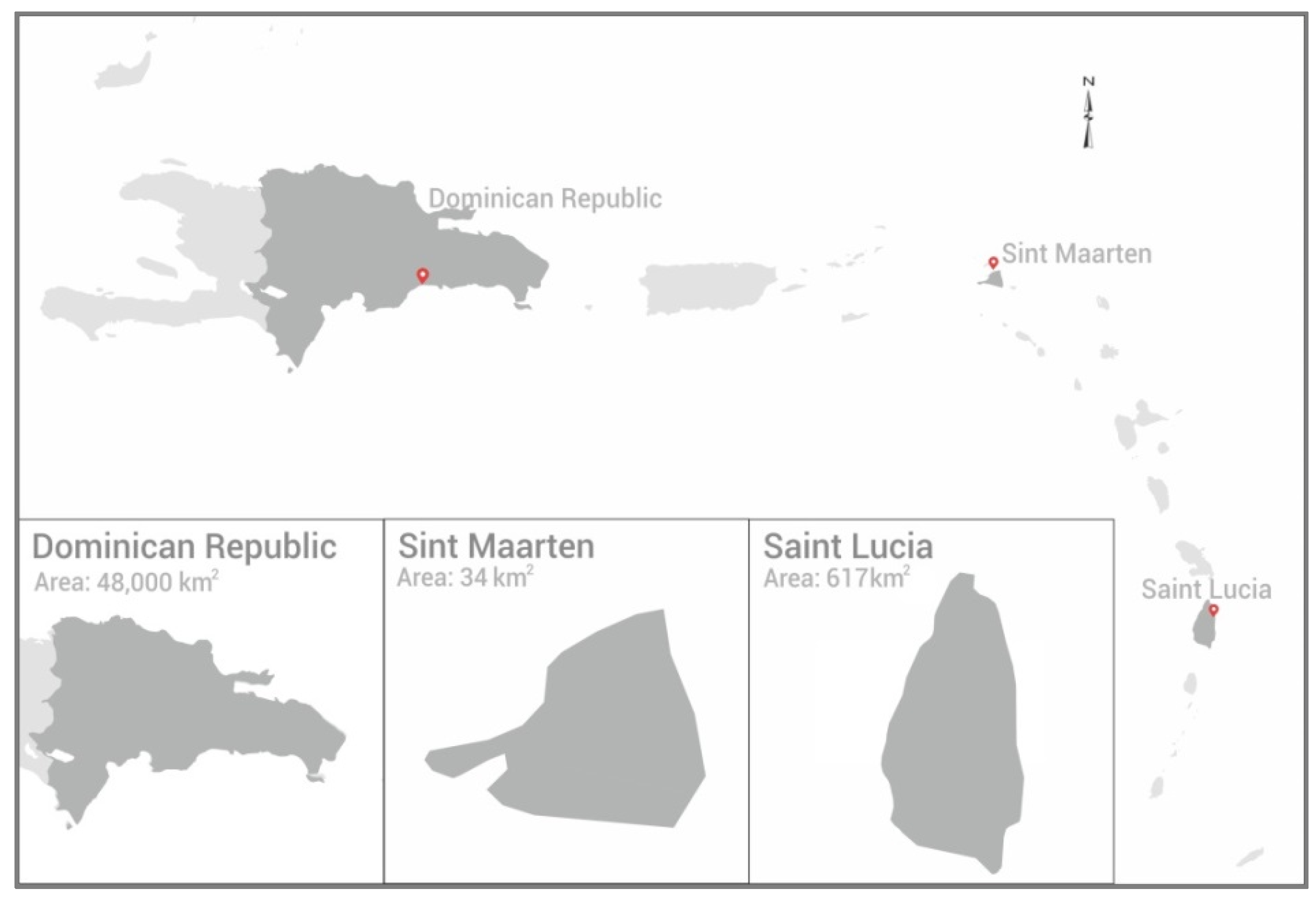
1.3.2. Dominican Republic
1.3.3. Saint Lucia
1.3.4. Sint Maarten
2. Materials and Methods
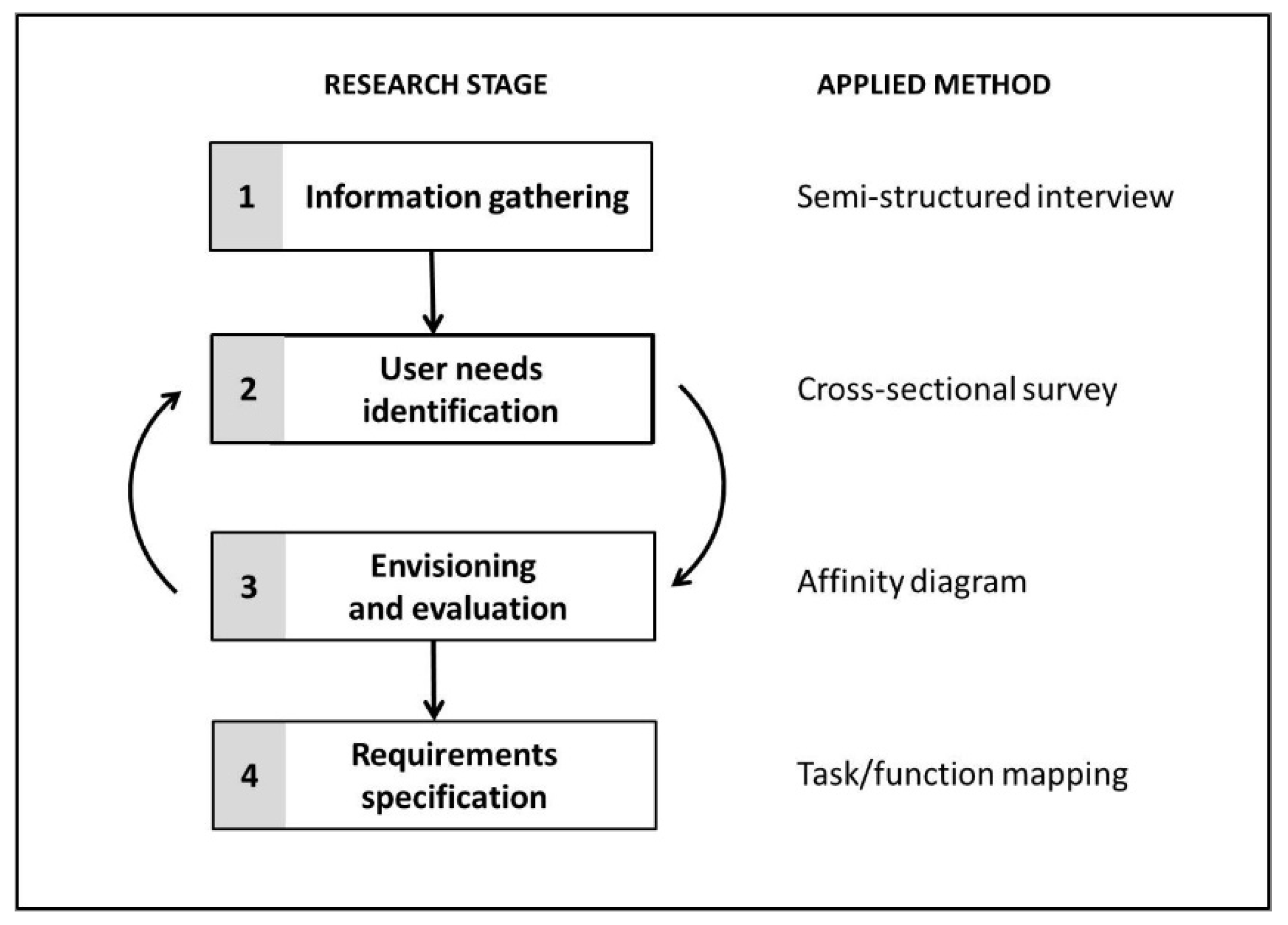
2.1. Research Stages
2.1.1. Information Gathering
2.1.2. User Needs Identification
2.1.3. Envisioning and Evaluation
2.1.4. Requirements Specification
2.2. Cases Selection
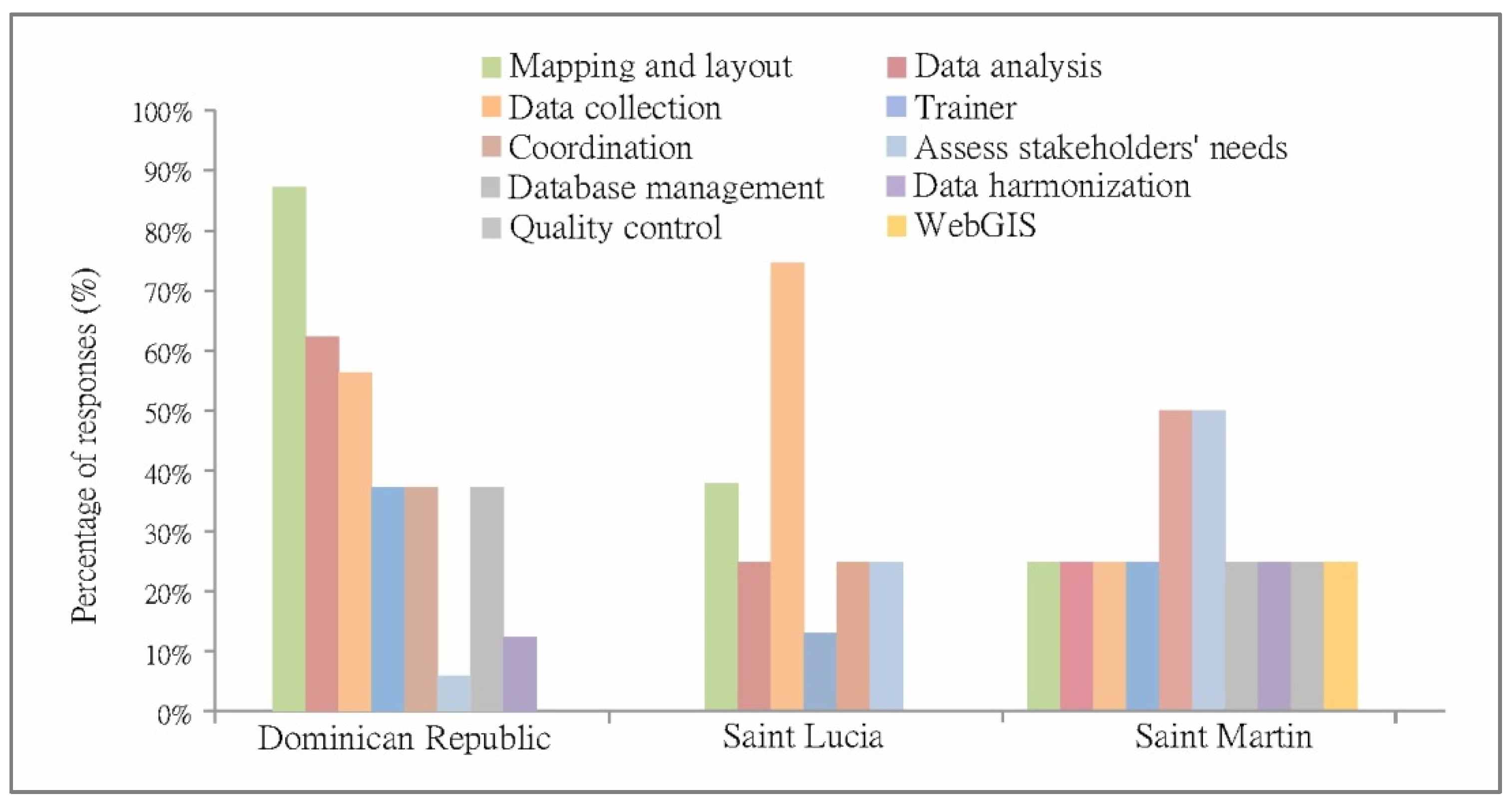
2.3. Survey Population
3. Results
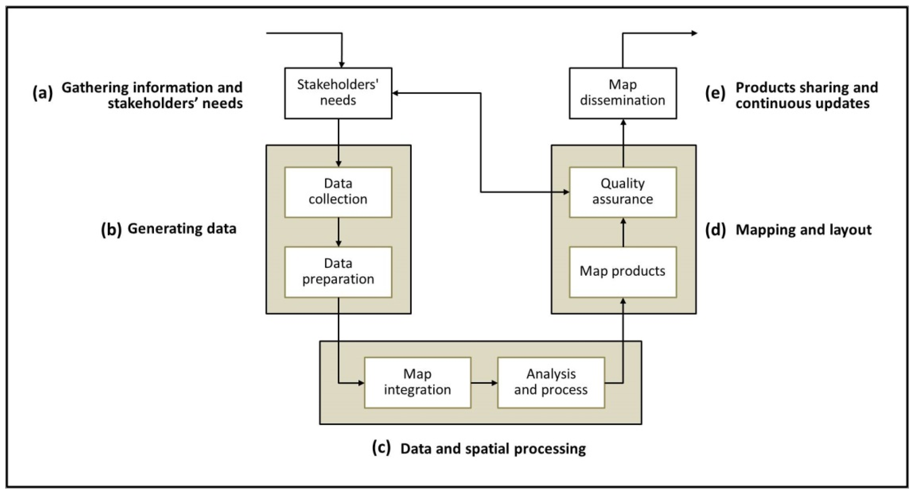
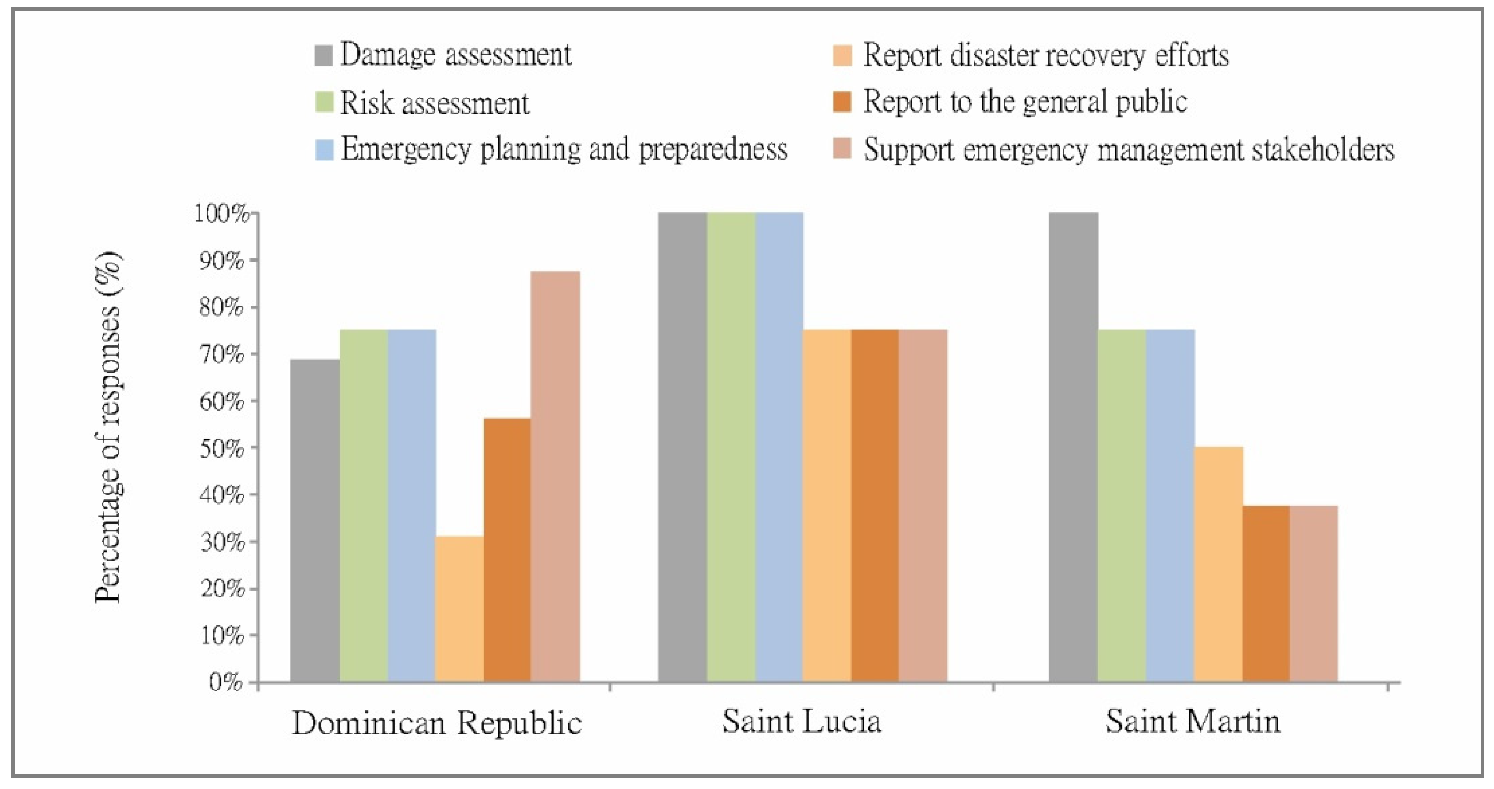
3.1. Gathering Information and Stakeholders’ Needs
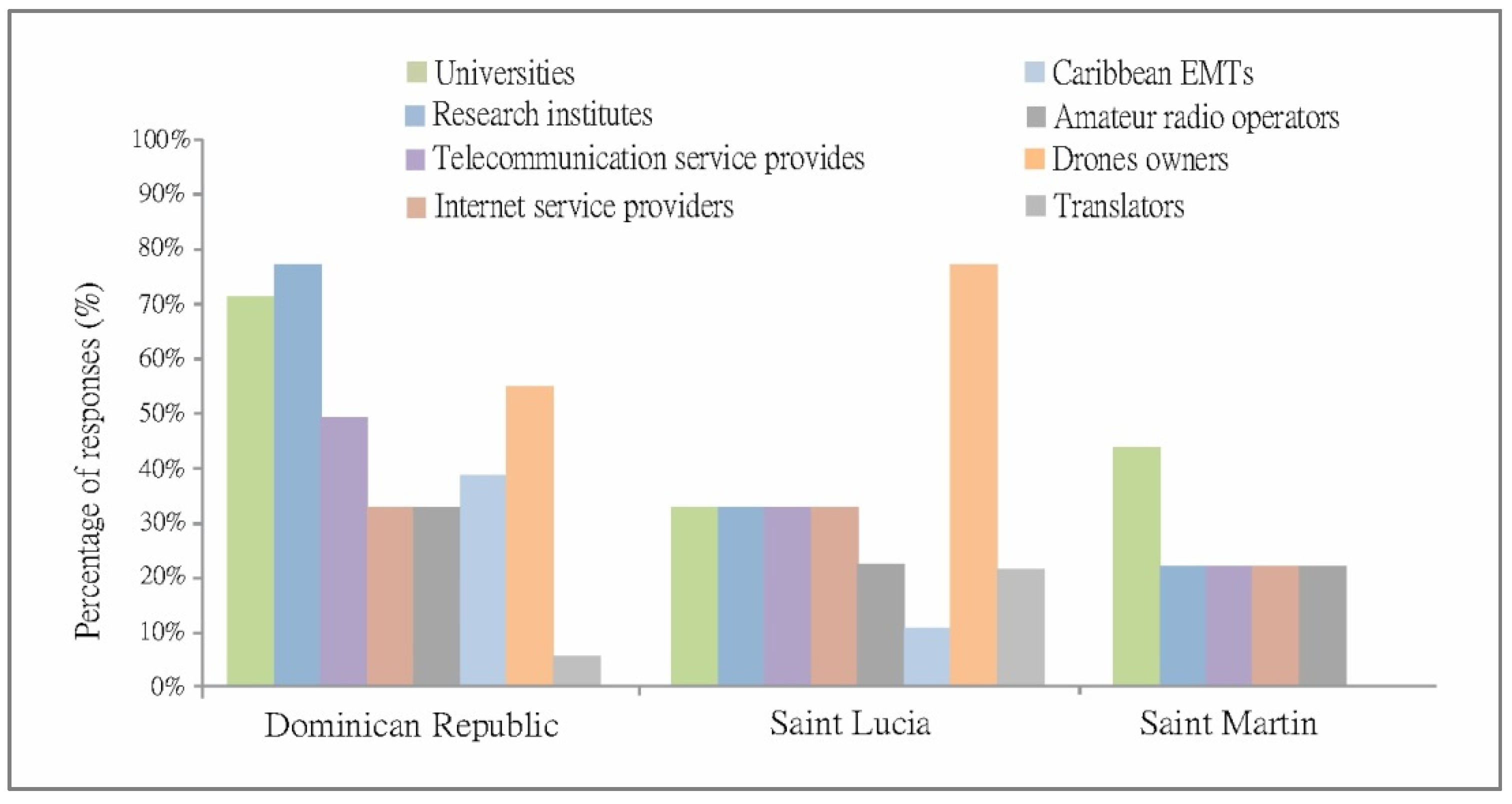
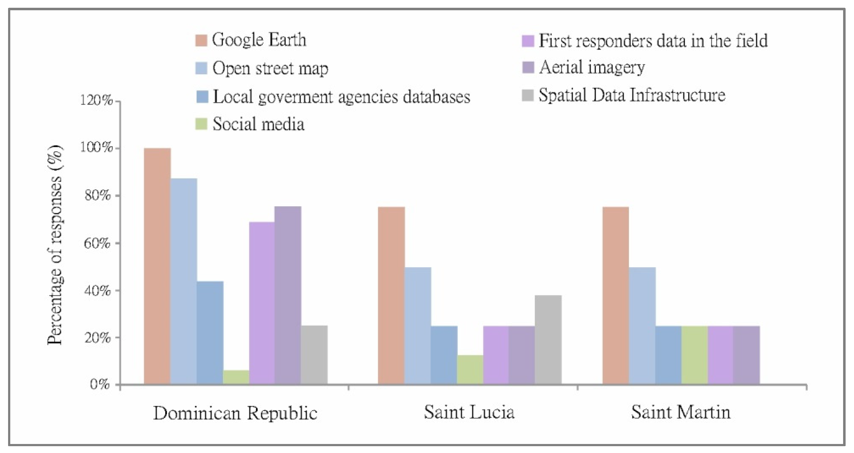
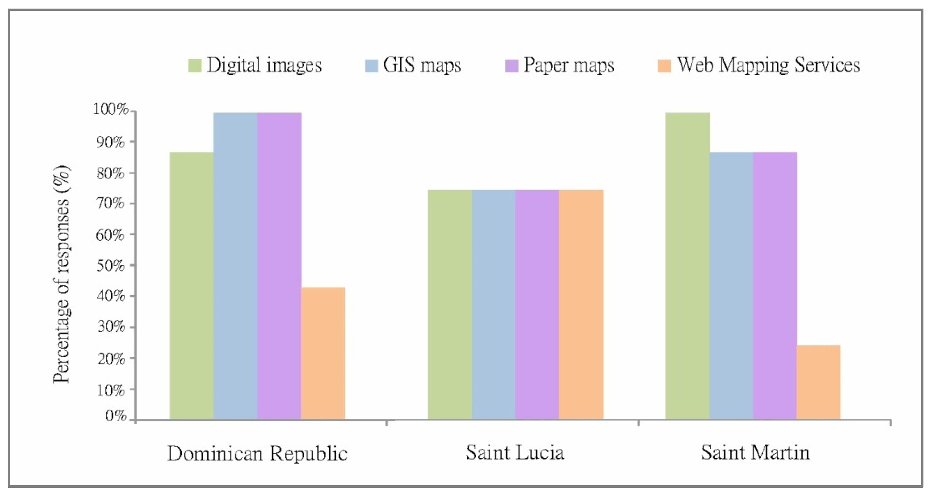
3.2. Generating Data
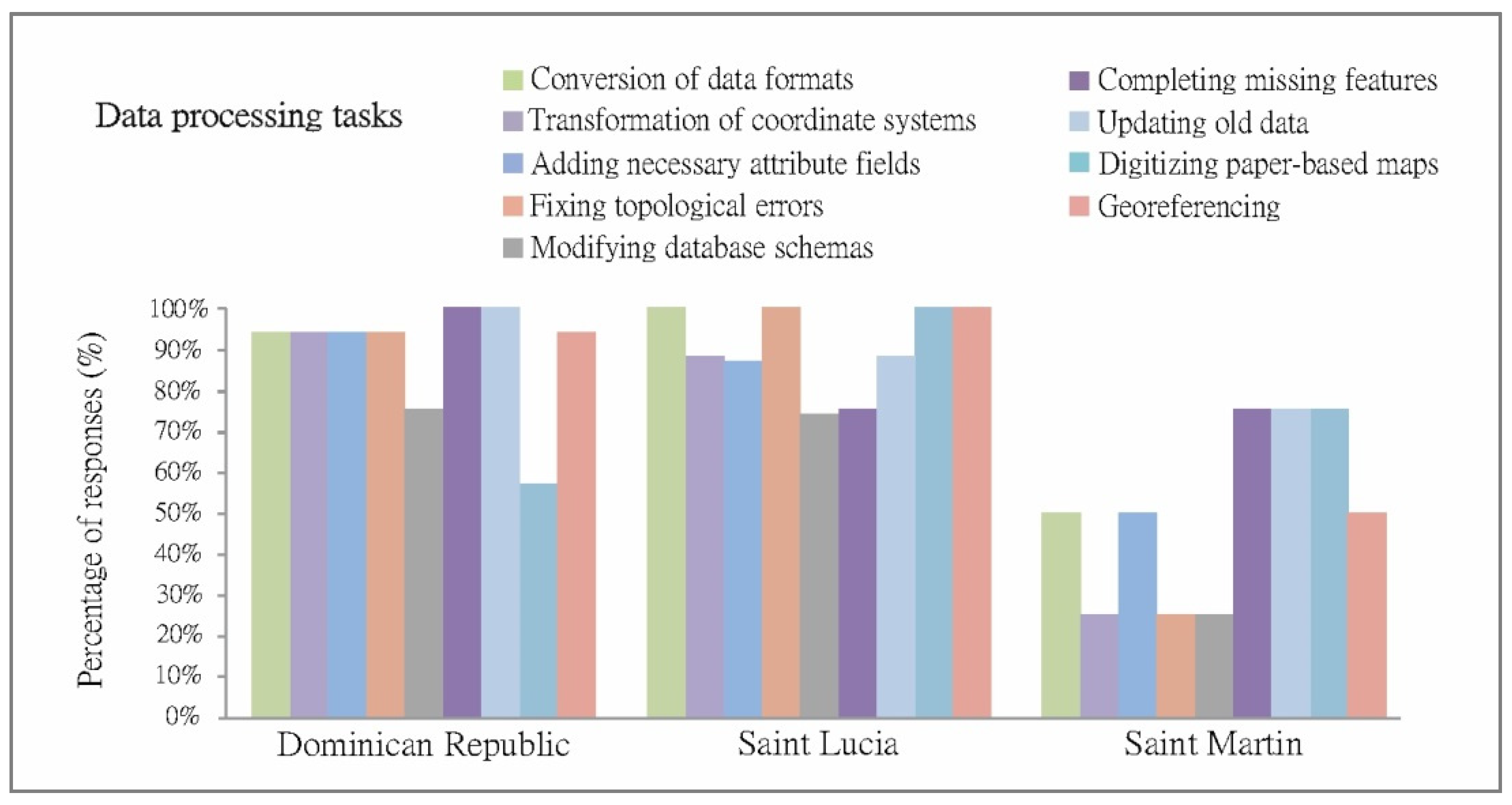
3.3. Data and Geospatial Processing
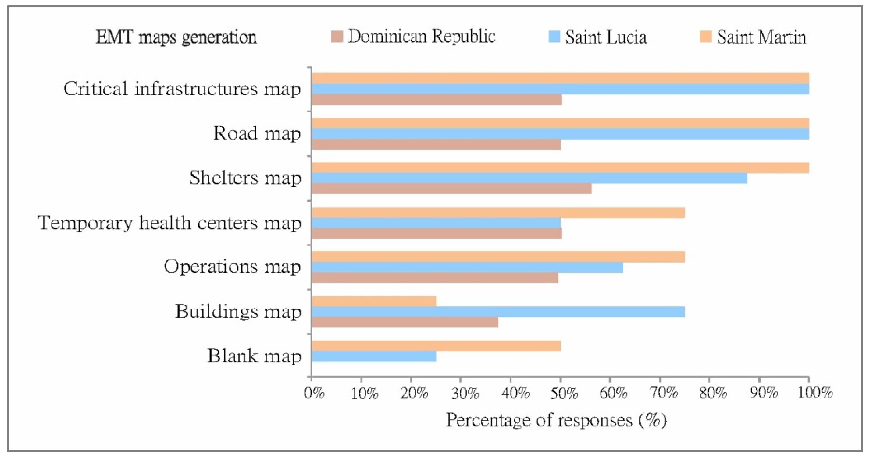
3.4. Mapping and Layout
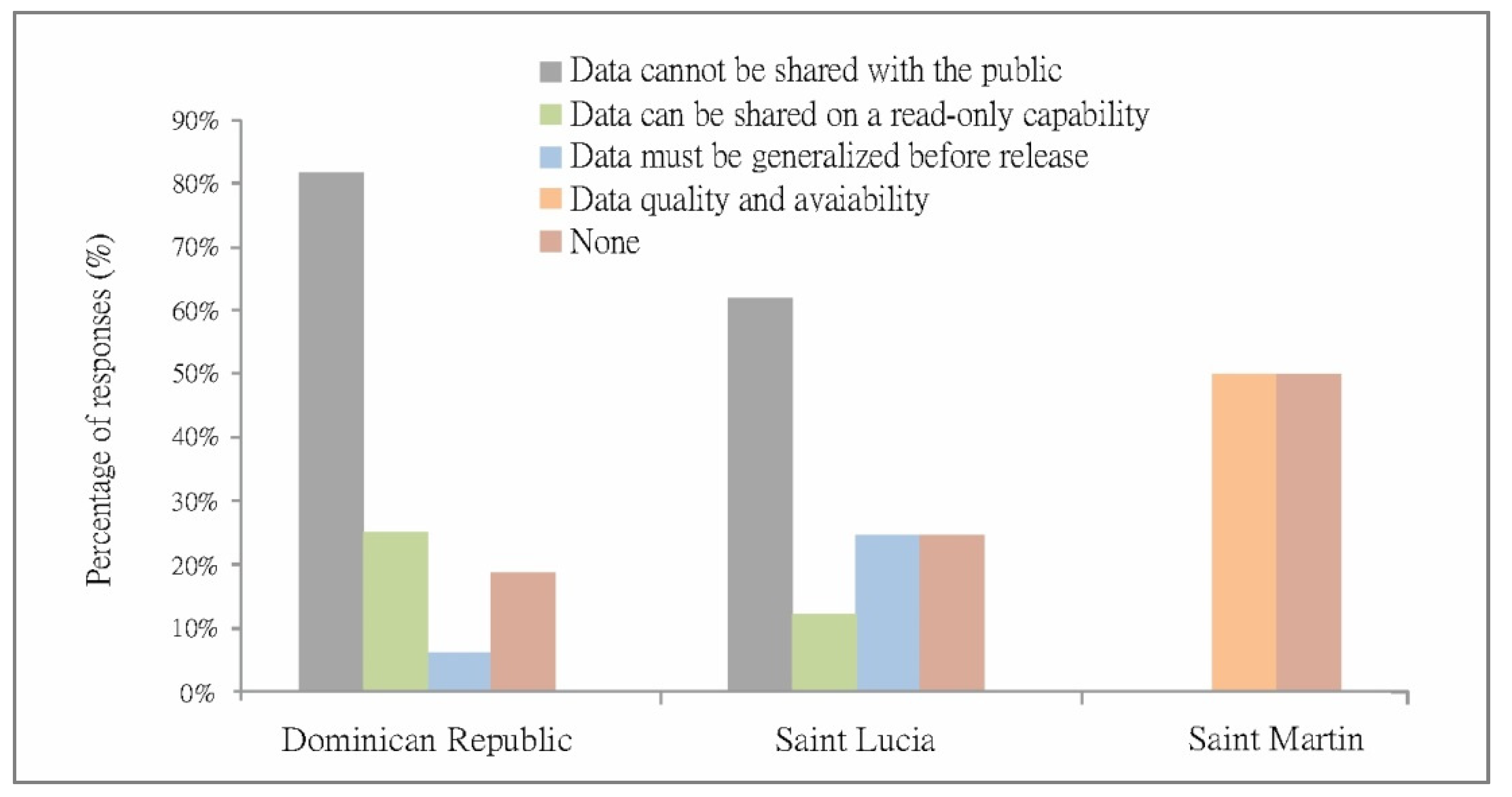
3.5. Product Sharing and Continuous Updates
4. Discussion
5. Conclusions
Author Contributions
Funding
Acknowledgments
Conflicts of Interest
Appendix A

| Category | Dominican Republic | Saint Lucia | Sint Maarten |
|---|---|---|---|
| Effective Communication |
|
|
|
| Automatization of processes |
|
|
|
| Training |
|
|
|
| Coordination |
|
|
|
| Standardization |
|
|
|
| Data specification |
|
|
|
| Category | Dominican Republic | Saint Lucia | Sint Maarten |
|---|---|---|---|
| Geospatial data and metadata |
|
|
|
| Human resources and capacity building |
|
|
|
| Tools for data collection |
|
|
|
| Standardization |
|
|
|
| Coordination |
|
|
|
| Categories | Dominican Republic | Saint Lucia | Sint Maarten |
|---|---|---|---|
| Distributed processing |
|
|
|
| Spatial data infrastructure |
|
|
|
| Standardization |
|
|
|
| Capacity building |
|
|
|
| Categories | Dominican Republic | Saint Lucia | Sint Maarten |
|---|---|---|---|
| Standardization |
|
|
|
| Technical capabilities |
|
|
|
| Geospatial information |
|
|
|
| Organizational capabilities |
|
|
|
| Categories | Dominican Republic | Saint Lucia | Sint Maarten |
|---|---|---|---|
| Spatial data infrastructure |
|
|
|
| Participatory mapping and capacity building |
|
|
|
| Standardization |
|
|
|
References
- UNISDR. Sendai Framework for Disaster Risk Reduction 2015–2030; United Nations Office for Disaster Risk Reduction (UNISDR): Geneva, Switzerland, 2015. [Google Scholar]
- CRED EM-DAT. The International Disaster Database. Centre for Research on the Epidemiology of Disasters (CRED). 2020. Available online: http://www.emdat.be/ (accessed on 1 June 2020).
- OCHA-UN. Impact of Hurricanes Irma and Maria Conference Supporting Document; Office for the Coordination of Humanitarian Affairs Assessment Capacities Project United Nations Development Programme: New York, NY, USA, 2018. [Google Scholar]
- Yates, D.; Paquette, S. Emergency knowledge management and social media technologies: A case study of the 2010 Haitian earthquake. Int. J. Inf. Manag. 2011, 31, 6–13. [Google Scholar] [CrossRef]
- Diehl, S.; van der Heide, J. Geo-information breaks through sector think. In Geo-Information for Disaster Management; Springer: Berlin/Heidelberg, Germany, 2019; pp. 85–108. [Google Scholar]
- Haworth, B.; Whittaker, J.; Bruce, E. Assessing the application and value of participatory mapping for community bushfire preparation. Appl. Geogr. 2016, 76, 115–127. [Google Scholar] [CrossRef]
- Helmholz, P.; Zlatanova, S.; Barton, J.; Aleksandrov, M. Geoinformation for Disaster Management 2020 (GI4DM2020): PREFACE. ISPRS Ann. Photogramm. Remote Sens. Spatial Inf. Sci. 2020, VI-3, 1–2. [Google Scholar]
- Fernández, T.D.; Crompvoets, J. Evaluating Spatial Data Infrastructures in the Caribbean for sustainable development. In Proceedings of the GSDI-10 Conference, Small Island Perspectives on Global Challenges: The Role of Spatial Data in Supporting a Sustainable Future, St. Augustine, Trinidad and Tobago, 29 February 2008; p. 20. [Google Scholar]
- Kimura, R.; Munenari, I.; Keiko, T.; Takashi, F.; Haruo, H. Clarifying the Function of the Emergency Mapping Team in order to Allocate the Limited Resources in the Time of 2011 Great East Japan Earthquake. In Proceedings of the TIEMS (The International Emergency Management Society), Tokyo, Japan, 22–23 May 2012; pp. 72–78. [Google Scholar]
- Wolbers, J.; Boersma, K. The common operational picture as collective sensemaking. J. Contingencies Crisis Manag. 2013, 21, 186–199. [Google Scholar] [CrossRef]
- Kevany, M. GIS in the World Trade Center response: 10 years after. ISPRS Int. Arch. Photogramm. Remote Sen. Spatial Inf. Sci. 2011, XXXVIII, 137–142. [Google Scholar] [CrossRef]
- Michel, G.R.; Tapia, S.M.; Aybar, F.M.; Javier, V.G.; Crompvoets, J. Identifying Users’ Requirements for Emergency Mapping Team Operations in the Dominican Republic. ISPRS Int. J. Geo-Inf. 2020, 9, 165. [Google Scholar] [CrossRef]
- Keiko, T.; Hayashi, H. Geospatial Information Improves the Decision-Making Process during the Disaster Response: The Experience of the Emergency Mapping Team in the 2011 off the Pacific Coast of Tohoku Earthquake Takashi. In Proceedings of the 15th World Conference on Earthquake Engineering, Lisbon, Portugal, 24–28 September 2012. [Google Scholar]
- Menold, J.; Weizler, L.; Liu, L.; Bilén, S.G.; Miller, S. Identifying end-user requirements for communication systems in disadvantaged environments. In Proceedings of the 2015 IEEE Global Humanitarian Technology Conference, Seattle, WA, USA, 8–11 October 2015; pp. 284–291. [Google Scholar]
- Leitinger, S.H.; Scheidl, C.; Kollarits, S.; Hübl, J. User Requirements for a Mobile Disaster Documentation System. In Geo-Information for Disaster Management; van Oosterom, P., Zlatanova, S., Fendel, E.M., Eds.; Springer: Berlin/Heidelberg, Germany, 2005; pp. 305–310. [Google Scholar]
- Neuvel, J.M.M.; Scholten, H.J.; van den Brink, A. From Spatial Data to Synchronised Actions: The Network-centric Organisation of Spatial Decision Support for Risk and Emergency Management. Appl. Spat. Anal. Policy 2012, 5, 51–72. [Google Scholar] [CrossRef]
- Ajmar, A.; Boccardo, P.; Disabato, F.; Tonolo, F.G. Rapid Mapping: Geomatics role and research opportunities. Rendiconti Lincei. Scienze Fisiche Naturali 2015, 26, 63–73. [Google Scholar] [CrossRef]
- Michel, G.R.; Syu, H.S.; Hong, J. A Spatial Data Infrastructure Perspective to Facilitate Emergency Mapping Team Operations. In Proceedings of the 34th Asian Conference on Remote Sensing 2013, ACRS 2013, Bali, Indonesia, 20–24 October 2013; Volume 5, pp. 4120–4127. [Google Scholar]
- Courage, C.; Baxter, K. Understanding your Users: A Practical Guide to User Requirements Methods, Tools, and Techniques; Gulf Professional Publishing: Houston, TX, USA, 2005. [Google Scholar]
- Soares, D.S.; Cioquetta, M.; Souza, D. Analysis of techniques for documenting user requirements. In Proceedings of the Computational Science and Its Applications—ICCSA 2012, Salvador de Bahia, Brazil, 18–21 June 2012; Volume 7336, pp. 16–28. [Google Scholar]
- Snoeren, G.; Zlatanova, S.; Crompvoets, J.; Scholten, H. Spatial Data Infrastructure for emergency management: The view of the users. In Proceedings of the 3rd GiDM, Toronto, ON, Canada, 22–25 July 2007; pp. 1–12. [Google Scholar]
- UNFCCC. Vulnerability and Adaptation to Climate Change in Small Island Developing States; United Nations Framework Convention on Climate Change: New York, NY, USA, 2007; p. 38. [Google Scholar]
- UN-OHRLLS. Small Island Developing States in Numbers; UN Office of the High Representative for the Least Developed Countries, Landlocked Developing Countries and Small Island Developing States: New York, NY, USA, 2015. [Google Scholar]
- Schmid, J.P. CaribbeanDEVTrends. The Caribbean Economic Outlook in Three Graphs. 2019. Available online: https://blogs.iadb.org/caribbean-dev-trends/en/the-caribbean-economic-outlook-in-three-graphs/ (accessed on 10 June 2020).
- World Bank. Disaster Risk Management in Latin America and the Caribbean Region: GFDRR Country Notes; World Bank: Washington, DC, USA, 2012. [Google Scholar]
- National Bureau of Statistic. Tu Municipio en Cifras. IX Censo Nacional de Población y Vivienda 2010. 2019. Available online: https://www.one.gob.do/provinciales-y-municipales/tu-municipio-en-cifras/ (accessed on 10 June 2020).
- WMO. Atlas of Mortality and Economic Losses from Weather, Climate and Water Extremes (1970–2012); United Nations Office for Disaster Risk Reduction (UNISDR): Geneva, Switzerland, 2014. [Google Scholar]
- National Geological Survey. Estudio de la Amenaza Sísmica y Vulnerabilidad Física del Gran Santo Domingo. Santo Domingo, Dominican Republic. 2015. Available online: http://sgn.gob.do/index.php/servicios/noticias/item/consultoria-especialista-en-norma-sismica-2 (accessed on 10 June 2020).
- PAHO. Saint Lucia. Health in the Americas. 2015. Available online: https://www.paho.org/salud-en-las-americas-2017/?p=4211 (accessed on 11 June 2020).
- UN-OHRLLS. About the Small Island Developing States. UN Office of the High Representative for the Least Developed Countries, Landlocked Developing Countries and Small Island Developing States. 2017. Available online: http://unohrlls.org/about-sids/ (accessed on 10 October 2020).
- GFDRR. Saint Lucia. 2020. Available online: https://www.gfdrr.org/en/saint-lucia (accessed on 11 June 2020).
- VNG International. Enhanced Resilience to Respond to Disasters. Recovery Project Sint Maarten; VNG International: The Hague, The Netherlands, 2018. [Google Scholar]
- VROMI. About Ministry of Public Housing, Spatial Planning, Environment and Infrastructure. 2020. Available online: http://www.sintmaartengov.org/government/VROMI/Pages/About.aspx (accessed on 11 June 2020).
- Yin, R.K. Case Study Research: Design and Methods; SAGE Publications: Thousand Oaks, CA, USA, 2009; Volume 5. [Google Scholar]
- Maguire, M.; Bevan, N. User requirements analysis: A review of supporting methods. In Proceedings of the IFIP 17th World Computer Congress, Montréal, QC, Canada, 25–30 August 2002; pp. 133–148. [Google Scholar]
- Eide, A.W.; Haugstveit, I.M.; Halvorsrud, R.; Skjetne, J.H.; Stiso, M. Key challenges in multi-agency collaboration during large-scale emergency management. In Proceedings of the SINTEF Digital/Software and Service Innovation, Pisa, Italy, 13 November 2012; Volume 953. [Google Scholar]
- Waring, S.; Humann, M.; Dawson, N. Facilitators and barriers to effective information sharing during international disaster response. J. Emerg. Manag. 2019, 17, 469–486. [Google Scholar] [PubMed]
- Dusse, F.; Júnior, P.S.; Alves, A.T.; Novais, R.; Vieira, V.; Mendonça, M. Information visualization for emergency management: A systematic mapping study. Expert Syst. Appl. 2016, 45, 424–437. [Google Scholar] [CrossRef]
- McDougall, K. An Assessment of the Contribution of Volunteered Geographic Information during Recent Natural Disasters. In Spatially Enabling Government, Industry and Citizens: Research and Development Perspectives; Rajabifardb, A., Colleman, D., Eds.; GSDI Association Press: Needham, MA, USA, 2012; pp. 201–2014. [Google Scholar]
- Carley, K.M.; Malik, M.; Landwehr, P.M.; Pfeffer, J.; Kowalchuck, M. Crowd sourcing disaster management: The complex nature of Twitter usage in Padang Indonesia. Saf. Sci. 2016, 90, 48–61. [Google Scholar] [CrossRef]
- Genovese, E.; Stéphane, R. Potential of VGI as a Resource for SDIs in the North/South Context. Geomatica 2010, 64, 439–450. [Google Scholar]
- Vratonjić, M.; Wittmann, H. Using and Optimising GIS in an Emergency Response; European Emergency Number Association: Brussels, Belgium, 2015; pp. 13–14. [Google Scholar]
- UN-GGIM. Future Trends in Geospatial Information Management: The Five to Ten Year Vision, 3rd ed.; UN-GGIM: New York, NY, USA, 2020. [Google Scholar]
- Bharosa, N.; Lee, J.; Janssen, M. Challenges and obstacles in sharing and coordinating information during multi-agency disaster response: Propositions from field exercises. Inf. Syst. Front. 2010, 12, 49–65. [Google Scholar] [CrossRef]
- Boccardo, P. New perspectives in emergency mapping. Eur. J. Remote Sens. 2013, 46, 571–582. [Google Scholar] [CrossRef]
- Comfort, L.K.; Kapucu, N. Inter-organizational coordination in extreme events: The World Trade Center attacks, September 11, 2001. Nat. Hazards 2006, 39, 309–327. [Google Scholar] [CrossRef]
- Mcdougall, K.; Rajabifard, A.; Williamson, I. A mixed-method approach for evaluating spatial data sharing partnerships for spatial data infrastructure development. Res. Theory Adv. Spat. Data Infrastruct. Concepts 2007, 5, 55–73. [Google Scholar]
- Crompvoets, J.; Bregt, A.; Rajabifard, A.; Williamson, I. Assessing the worldwide developments of national spatial data clearinghouses. Int. J. Geogr. Inf. Sci. 2004, 18, 665–689. [Google Scholar] [CrossRef]
- Georgiadou, Y.; Budhathoki, N.R.; Nedovic-Budic, Z. An Exploration of SDI and Volunteered Geographic Information in Africa. In Spatial Data Infrastructures in Context, 1st ed.; CRC Press: Boca Raton, FL, USA, 2011; p. 18. [Google Scholar]


Publisher’s Note: MDPI stays neutral with regard to jurisdictional claims in published maps and institutional affiliations. |
© 2021 by the authors. Licensee MDPI, Basel, Switzerland. This article is an open access article distributed under the terms and conditions of the Creative Commons Attribution (CC BY) license (https://creativecommons.org/licenses/by/4.0/).
Share and Cite
Rosario Michel, G.; Manzano Aybar, F.; Neris Guzmán, L.; Villalta Calderón, C.; Durán, T.J.; Crompvoets, J. Identifying Users’ Requirements for Emergency Mapping Team Operations in Small Island Developing States: Caribbean Perspective. ISPRS Int. J. Geo-Inf. 2021, 10, 307. https://doi.org/10.3390/ijgi10050307
Rosario Michel G, Manzano Aybar F, Neris Guzmán L, Villalta Calderón C, Durán TJ, Crompvoets J. Identifying Users’ Requirements for Emergency Mapping Team Operations in Small Island Developing States: Caribbean Perspective. ISPRS International Journal of Geo-Information. 2021; 10(5):307. https://doi.org/10.3390/ijgi10050307
Chicago/Turabian StyleRosario Michel, Gregorio, Fernando Manzano Aybar, Leris Neris Guzmán, Christian Villalta Calderón, Teodoro Jiménez Durán, and Joep Crompvoets. 2021. "Identifying Users’ Requirements for Emergency Mapping Team Operations in Small Island Developing States: Caribbean Perspective" ISPRS International Journal of Geo-Information 10, no. 5: 307. https://doi.org/10.3390/ijgi10050307
APA StyleRosario Michel, G., Manzano Aybar, F., Neris Guzmán, L., Villalta Calderón, C., Durán, T. J., & Crompvoets, J. (2021). Identifying Users’ Requirements for Emergency Mapping Team Operations in Small Island Developing States: Caribbean Perspective. ISPRS International Journal of Geo-Information, 10(5), 307. https://doi.org/10.3390/ijgi10050307