
Understanding the Relationship between Dominant Geo-Environmental Factors and Rural Poverty in Guizhou, China


State Key Laboratory of Resources and Environmental Information System, Institute of Geographic Sciences and Natural Resources Research, Beijing 100101, China
*
Author to whom correspondence should be addressed.
ISPRS Int. J. Geo-Inf. 2021, 10(5), 270; https://doi.org/10.3390/ijgi10050270
Submission received: 22 March 2021
/
Revised: 14 April 2021
/
Accepted: 20 April 2021
/
Published: 22 April 2021
Abstract
:Geo-environmental factors are believed to be major determinants of rural poverty. However, few studies have quantified the effects of these factors on rural poverty in China. In this paper, we used county-level poverty incidence data and geo-environmental factors to explore spatial patterns of the incidence of poverty using global and local spatial autocorrelation analysis and to investigate the effect of geo-environment factors on rural poverty using a geo-detector model. Our results demonstrated that there was spatial clustering of the incidence of poverty in the study area. The incidence of poverty decreased from south to north and from the east and west to the central area. The incidence of high–high poverty areas was mainly distributed in the southeast of Guizhou Province and the incidence of low–low poverty areas was distributed in the northeast. The results also demonstrated that percentage of effective irrigation on arable land, slope, elevation and vegetation cover were the dominant factors explaining the spatial pattern of poverty. Interaction analysis demonstrated that the slope non-linearly enhanced the percentage of effective irrigation on arable land. Our findings suggested that geo-environment is the fundamental control factor explaining the spatial pattern of rural poverty in China. Through analysis of the impact of the geo-environment on the spatial pattern of poverty, this study provides a reference for effectively implementing targeted alleviation of poverty.
1. Introduction
The eradication of poverty has been a dream of mankind since ancient times, the common mission of mankind and the greatest global challenge facing the world today [1,2,3]. Since the economic reforms and opening-up of China and with the rapid development of the country’s economy, poverty alleviation has also made remarkable progress. According to the statistics, over 700 million poor people have been lifted out of poverty from 1978 to 2012 [4]. China has become the first country in the world to complete the goal of “halving the proportion of the poor” set by the United Nations (UN) [5]. In particular, after China launched a targeted poverty alleviation (TPA) strategy in 2013, the incidence of poverty decreased substantially from 8.5% in 2013 to 1.7% in 2018. This new type of poverty alleviation strategy is proposed by the central government of China and is built on a detailed top-level design to promote policy implementation [4]. China has invested unprecedented resources and has also made a significant contribution to the reduction of poverty worldwide, particularly after TPA initiated [6]. A series of policies have been implemented to ensure the poor population escape poverty, such as resettlement, health insurance, industrial development and housing maintenance. With the great endeavor followed by the guidance of TPA, China has ended all extreme poverty by the year of 2020 [7]. However, inequality of socio-economic development between rural and urban areas is still existed.
Many factors contribute to rural poverty, including socio-economic underdevelopment, a lack of appropriate institutions and policies and geo-environmental and other constraints with clear regional characteristics [8,9,10,11,12]. Rural poverty in China is mainly distributed in mountainous and hilly areas, rocky desertification areas and other areas with harsh geo-environments [13]. Previous studies suggested that geo-environmental factors, such as topography (elevation, slope), climate (temperature, precipitation), water resources and land use, are important determinants to rural poverty [14,15,16]. Topography has been identified as a fundamental factor that can determine the availability and quality of the cultivated land and thus affect the agricultural productivity and livelihood of local farmers. Severe soil erosion and poor transportation are frequently occurred in areas with steeper slopes, which lead to low level of production potential and underdeveloped socioeconomic conditions [15]. In addition, agricultural production is largely constrained by temperature, rainfall and water availability. For example, rainfall and its variability are identified as a significant climatic stress on the agricultural production [16] and is significantly related to rural poverty in Kenya [14]. Accessibility to water resource (distance from river) determine the likelihood of irrigation of cultivated land and thus affect the agricultural potential and returns from land. Farmers in Guizhou province benefits from different type of land resources like arable land and forest. Agricultural production and forest products generally contribute a substantial share of total household income [17,18]. Therefore, geo-environmental factors play a fundamental role in forming rural poverty.
Because of geo-environmental factors, infrastructure in these areas is weak, it is difficult to increase income and consequently it is difficult to eradicate poverty. The occurrence and the degree of poverty are closely related to the geo-environment. Poverty is the result of long-term effects of humans and the geo-environment, in addition to the basic conditions that influence the evolution of human-land relations in the future. Over 40% of the population of poor people in China is distributed in particular areas of the geo-environment, of which 19% is in rocky desertification areas [19]. The relationship between the geo-environment and poverty have been widely studied by geographers [20,21,22]. Research on the impact of the geo-environment on poverty has achieved substantial results, mainly in the following aspects: the relationship between “geographic capital” and income level [23,24], the theory of sustainable livelihood approaches to poverty alleviation [25,26,27] and geo-environmental vulnerability and poverty [28,29,30,31,32]. These studies focused on a qualitative description or theoretical model analyses and provided important evidence for our understanding of the environment-poverty nexus. However, there are few quantitative investigations of the effects of geo-environmental factors on rural poverty. In addition, although China has ended extreme poverty, there is still a great challenge to reduce relative poverty the and inequality of socio-economic development. Considering the importance of the geo-environment on rural poverty and rural development, improving the understanding of the impacts of geo-environmental factors on rural poverty can provide valuable insights into future policies in order to narrow the socio-economic development gap.
Several studies have recently attempted to explore these questions using models and methods such as the back propagation (BP) neural network model [33], spatial analysis [34,35], multiple linear regression [36,37] and geographically weighted regression [38,39]. However, these studies focused on investigating individual factors, rather than interactions among factors. Indeed, two factors that interact with each other have differences in strength, direction and exhibit linearity or non-linearity, which is clearly not the case for a single factor [40,41,42]. Overlooking the effects of interactions among geo-environmental factors on poverty leads to misleading conclusions and a lack of understanding regarding the mechanisms underpinning rural poverty. Here, a geo-detector model was used to identify factors that influence the incidence of poverty and to examine the interaction effects between these factors. This model is an effective tool to study the driving forces of complex geographic elements [42].
In this paper, global and local spatial autocorrelations were used to explore the spatial pattern of the incidence of poverty in 2013 and a geo-detector model was used to identify the dominant geo-environmental factors explaining the incidence of poverty in Guizhou Province, China. Furthermore, we quantitatively examined the effects of individual factors and their interactions on the incidence of poverty and explored the possible pathways through which the geo-environment influences rural poverty. The incidence of poverty in 2013 was used to represent the poverty depth in the baseline period (before TPA initiated). Due to the unprecedented poverty alleviation efforts and large scale of policies under TPA (2014–2020), the incidence of poverty has reduced rapidly in 2014–2020 and the spatial pattern of incidence of poverty has changed. Therefore, the incidence of poverty in 2013 can provide opportunity to enhance the understanding of how geo-environmental factors form rural poverty excluding the impact of TPA policies.
2. Materials and Methods
2.1. Study Area
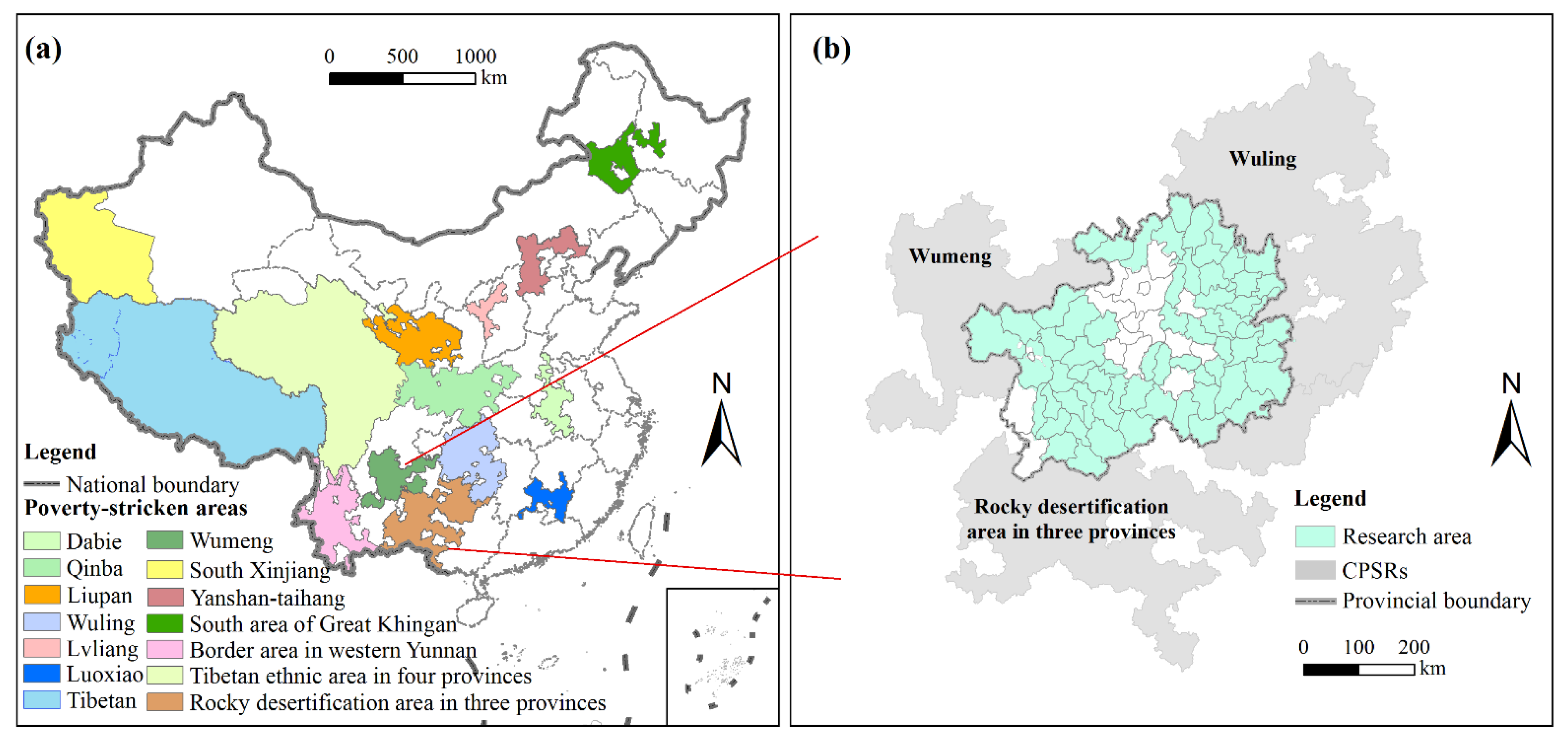
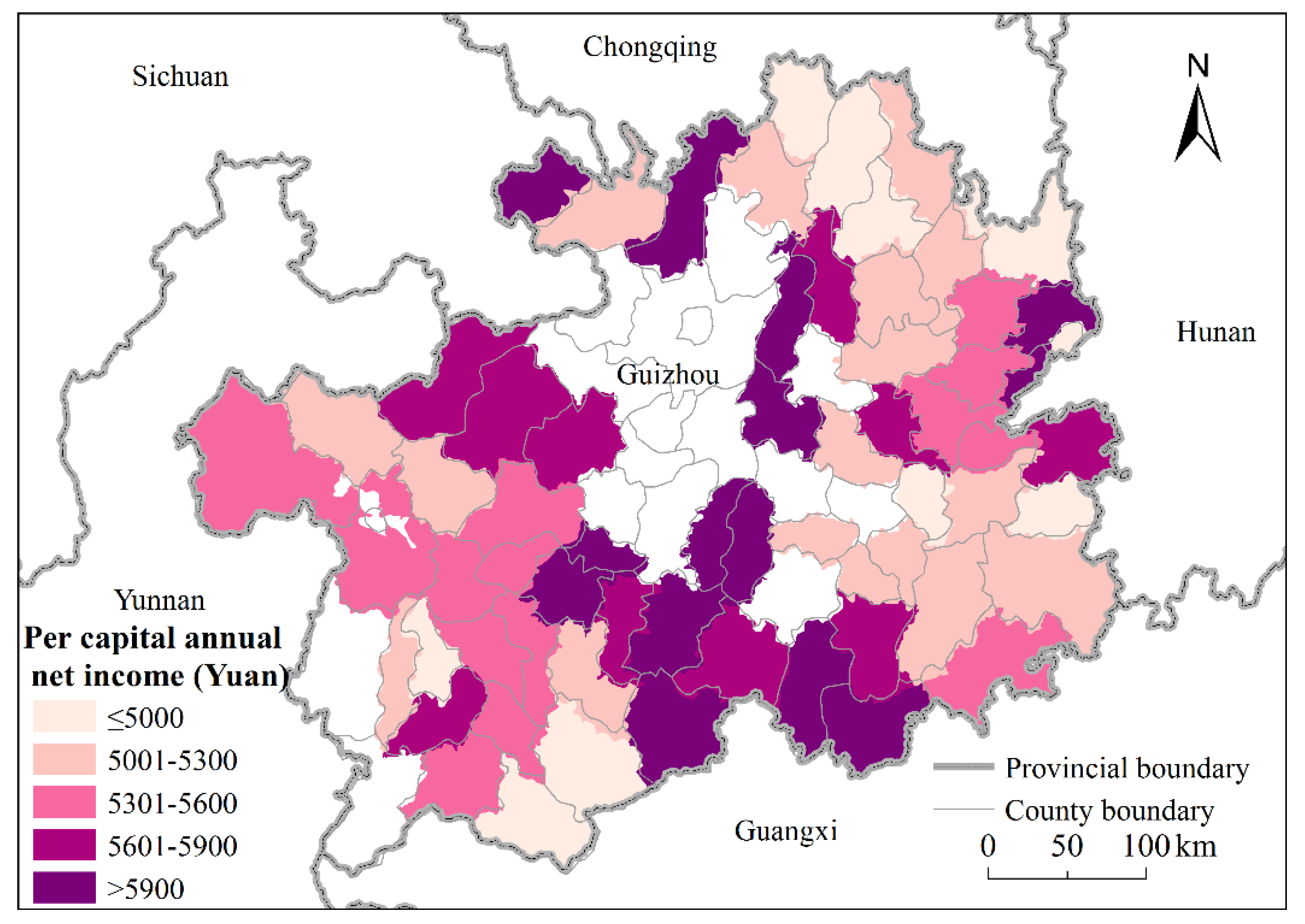
Guizhou Province is located in the southwest of China. It spans the Wuling and Wumeng areas and includes rocky desertification areas of three provinces (Figure 1). According to the 2011 definition of poverty as a per capita annual net income less than 2300 yuan, in 2013, the rural poor population was 7.45 million in Guizhou Province and it had 65 poverty-stricken counties (districts), including 15 counties (districts) in the Wuling area, 10 counties (districts) in the Wumeng area and 40 counties (districts) in the rocky desertification regions of three provinces. Figure 2, Figure 3 and Figure 4 show the spatial distribution of per capita annual net income, terrain relief within each county, and main road within study area.
Guizhou Province is mainly mountainous and hilly, with diffused rocky desertification and low environmental carrying capacity and karst-exposed areas account for 61.92% of the total area of the province. The living environment is extremely poor [43]. Due to the hostile and ecologically fragile environment and underdeveloped infrastructure, Guizhou Province has become the region with the most extensive and deepest poverty [44]. New poverty standards and diversified poverty alleviation goals have placed higher demands on work to alleviate poverty in Guizhou Province. The characteristics of Guizhou Province have commonalities with other areas.
2.2. Materials
2.2.1. Selection of Covariates
Geo-environmental factors that were used in this study include topography, climate, water resources and land use (Table 1). In China, agricultural development is critical to poverty alleviation. Its contribution to poverty alleviation is four times that of secondary and tertiary industries [45]. The geo-environment plays an extremely important role in agricultural production, particularly in poor areas. Furthermore, topography, climatic conditions, water resources and land use type are significant in explaining the spatial patterns of poverty [46,47]. Additionally, the level of poverty is higher in locations with a larger slope (>4%) than in very flat areas [48]. Similarly, factors that influence agricultural production, including precipitation, useable water per capita, arable land area and per capita forest land, also have a significant impact on poverty [49,50,51]. Good agricultural conditions and increasing the amount of land resources have greatly increased the income of farmers [52]. The following provides a short description of the four covariates used in the present study:
(1) Topography: In view of the complex topography and undulating terrain of the Guizhou Province, elevation, slope and terrain relief were selected as indicators to characterize topography.
(2) Climate: Temperature, precipitation, frost-free period and other climatic indicators have an important impact on agricultural production and the correlation between them is strong. Annual average temperature and annual average precipitation were selected as indicators of climatic conditions.
(3) Water resources: Water resources have a direct and extensive impact on regional life and production. The river density was selected as an indicator of water resources.
(4) Land use: Land is the material basis of production and important for agricultural development. The per capita arable land area, percentage of effective irrigation on arable land and vegetation cover were selected to reflect the land use status of the study area.
2.2.2. Data
The data used in this study included the incidence of poverty, topographic, meteorological, water resources and land use data. The specific sources of the data were as follows:
Poverty incidence: The incidence of county-level poverty was obtained from the Statistical Yearbook of Guizhou Province (2013).
Topographic data: These data were derived from a digital elevation model (DEM) and calculated by ArcGIS. The DEM data were obtained from the Resource and Environmental Science Data Center of the Chinese Academy of Sciences (http://www.resdc.cn, accessed on 11 February 2018), with a spatial resolution of 90 m. The DEM was derived from Shuttle Radar Topography Mission (SRTM), which was obtained from 2000. Slope (°) was generated in ArcGIS. Terrain relief (m) was defined as the difference between maximum elevation within each county and minimum elevation within each county. The calculation formula is: TR = Emax − Emin, where TR refers to terrain relief, Emax and Emin refer to maximum and minimum elevation within each county, respectively.
Climatic data: Annual average temperature and annual average precipitation with a spatial resolution of 1000 m in 2013 were sourced from the Resource and Environmental Science Data Center of the Chinese Academy of Sciences (http://www.resdc.cn, accessed on 11 February 2018). These data were interpolated by using thin plate spline algorithm based on 2400 meteorological stations in China and implemented in ANUSPLIN software [53].
Water resource data: River network datasets were obtained from the Resource and Environmental Science Data Center of the Chinese Academy of Sciences (http://www.resdc.cn, accessed on 11 February 2018). This data were obtained from 2015. River density (km/km2) was defined as the ratio between the length of river within each county and the area of each county.
Land use data: Per capita arable land area (km2/person) and vegetation cover (%) were based on the Google Earth Engine platform and interpreted using the Landsat 8 remote sensing image (30 m) of 2013. The land use data were derived from the previous study [54]. Training samples was created through visual interpretation by using high-resolution Google Earth images. Random forest was used as a classifier to classify Landsat 8 remote sensing images. Per capital arable land area was defined as the ratio between the area of arable land and the area of county. Vegetation cover was defined as the proportion of vegetation within each county.
The percentage of effective irrigation on arable land was derived from the Statistical Yearbook of Guizhou Province (2013) and Statistical Communique of National Economic and Social Development of Each County in 2013.
All the data within study area were extracted in ArcGIS. Average values of data within each county were calculated by using zonal statistics function in ArcGIS.
2.3. Methods
2.3.1. Spatial Autocorrelation Analysis
Spatial autocorrelation analysis is based on Tobler’s first law of geography [55,56], for which the correlation of a specific variable is analyzed at different locations. It encompasses global and local autocorrelation analysis. In this study, global autocorrelation was used to explore the spatial distribution pattern of poverty in the study area. The global Moran’s I was used to explore the spatial autocorrelation of the incidence of county-level poverty. Moran’s I was calculated as follows:
where n is the number of counties, and are the incidence of poverty of each county, is the mean incidence of poverty, is the spatial weight matrix and is the sum of the spatial weight matrices. The significance test of Moran’s I value is typically measured by the Z score and the formula is as follows:
where is the theoretical expectation and is the theoretical variance. When the Z score exceeds zero, the observed values are spatially agglomerated, that is, there is positive spatial autocorrelation: when the Z score is less than zero, the observed values are spatially dispersed, that is, there is negative spatial autocorrelation and when the Z score is equal to zero, the observed values are randomly distributed.
The global Moran’s I only indicates whether the incidence of poverty is spatially autocorrelated and does not reflect the specific location and characteristics of spatial clustering [57]. Therefore, in this study, local Moran’s I was used to identify local regions where a cluster of high or low rates of poverty occur [58]. Queen contiguity weight matrix was used and was created in GeoDa software (https://spatial.uchicago.edu/geoda, accessed on 11 February 2018).
2.3.2. Geo-Detector Model
The geo-detector model is a spatial statistical model that is used to quantify spatially stratified heterogeneity of the incidence of poverty and to identify the underlying causes [42]. It was first applied to health risk assessments [40]. The geo-detector plays an important role in investigating mechanisms within a complex geo-environment. Factor detection can test for spatial heterogeneity of univariate variables and interactor detection can test the influence of different factors on the response variable [41]. Factor detection and interaction detection were implemented by Geodetector software (http://geodetector.cn, accessed on 11 February 2018).
Factor detection: To detect the extent to which a factor explains a change, the incidence of poverty in the study area was defined as the response variable and the selected geo-environment variables were defined as explanatory variables. First, the natural breakpoint method was used to discretize the explanatory variables. It divides each explanatory variable into six strata, which converts them from numeric values to categories and then acquires the q value of each factor on the incidence of poverty:
where h = 1, ..., L is the strata of variable Y or factor X; and N are the number of cells in layer h and the entire region, respectively; and are the variance of Y of layer h and the entire zone, respectively; and SSW and SST are the sum of intra-layer squares and the total number of squares, respectively. The range of q is [0, 1] and the greater the value, the stronger the explanatory power in explaining the incidence of poverty.
Interaction detection: Interaction detection can quantitatively measure the power of interacting factors in explaining the incidence of poverty and clarifies the mode of action. First, the explanatory forces q(xa) and q(xb) of the two factors xa and xb for Y were calculated and then q(xa ∩ xb), when xa and xb interact, was calculated. q(xa), q(xb) and q(xa ∩ xb), were compared to assess whether the influence of the two-factor interaction was stronger or weaker than the single factor effect. Table 2 shows the two-factor interaction relationships.
3. Results
3.1. Spatial Pattern of County-Level Poverty
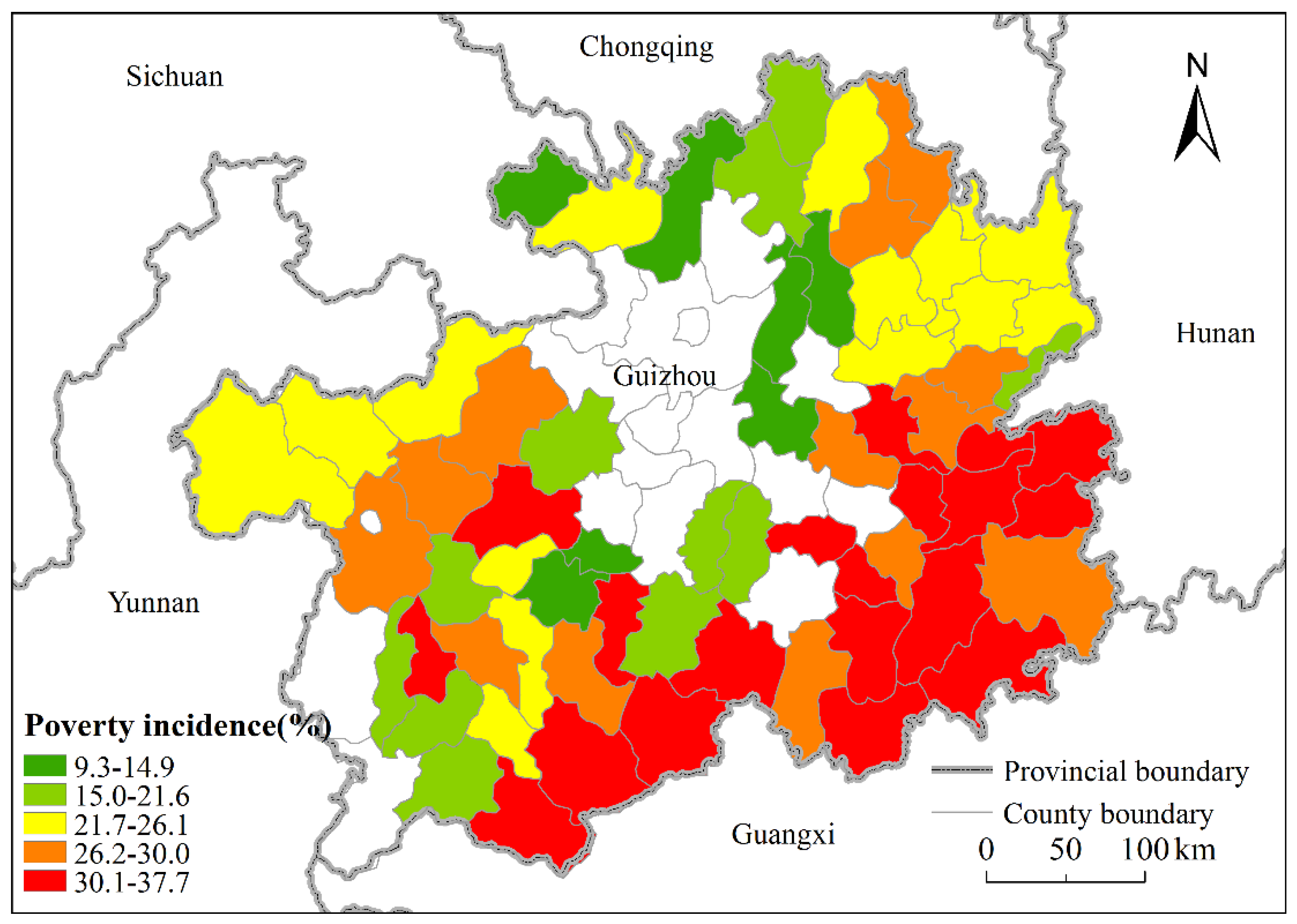
Figure 5 shows the spatial distribution of the incidence of poverty in Guizhou Province in 2013. There are clear regional differences in the incidence of poverty across the study area. The spatial distribution map shows that the incidence of poverty in the south is larger than in the north and the spatial difference of the east and west are larger than that of the central region. Areas with the deepest poverty are concentrated in the southern region. The incidence of poverty ranged from 30.1% to 37.3%, poor counties with an incidence of poverty between 26.2% and 30% are dispersed and counties with an incidence of poverty ranging from 21.7% to 26.1% are relatively concentrated in the northwest and northeast. Areas with low poverty levels are mainly located at the centre and northeast and the incidence of poverty is between 15–21.6% and 9.3–14.9%, respectively.
The global Moran’s I was used to test the spatial autocorrelation of the incidence of poverty in 2013. The results demonstrated that Moran’s I was 0.11 and the corresponding Z score was 4.82. This indicates that there was a positive spatial autocorrelation in the incidence of poverty, that is, the incidence of poverty in a county is positively affected by neighboring counties. Local autocorrelation demonstrated that the areas of incidence of high–high poverty were concentrated in the southeast of Guizhou Province (Figure 6), mainly at the junction of Qiandongnan and Qiannan. Furthermore, the incidence of poverty in this type of area and neighboring areas, was relatively high and it is relatively difficult to eradicate poverty. Areas with low–low incidence of poverty are distributed in the northeast of Guizhou Province, mainly in Zunyi. The incidence of poverty in this type of area and neighboring areas was relatively low and it is less difficult to eradicate poverty. A total of 9 (13.8%) high–high clusters and 5 (7%) low–low clusters were detected by local Moran’s I.
3.2. Analysis of Influencing Factors
3.2.1. Identification of Dominant Factors of the Spatial Pattern of County-Level Poverty
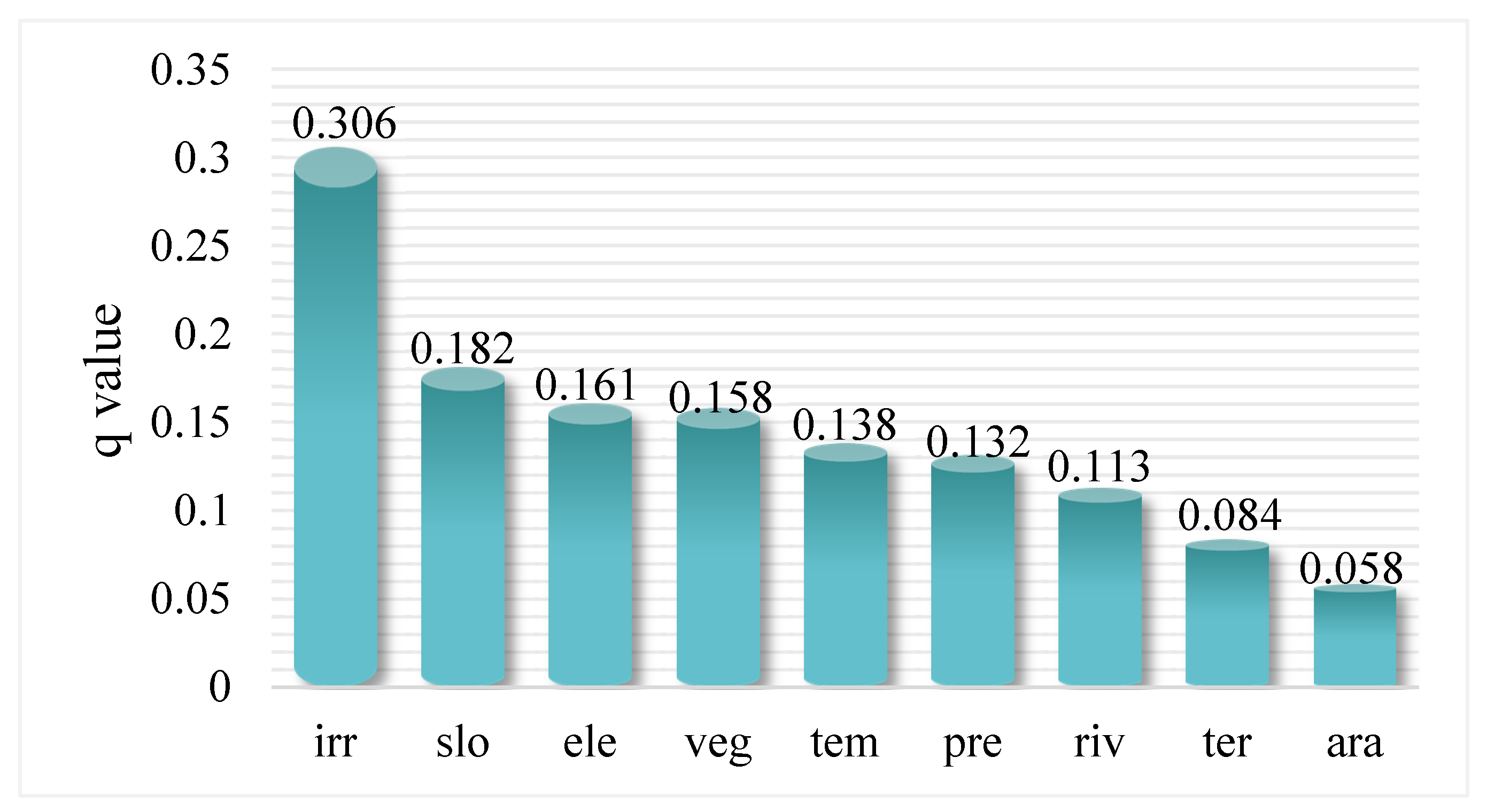
First, the nine covariates were detected and analyzed in relation to incidence of poverty using the geo-detector model. Figure 7 shows the factor detection results. The percentage of effective irrigation on arable land, topographic slope, elevation and vegetation cover had the highest q values: 0.306, 0.182, 0.161 and 0.158, respectively. This indicates that these four factors have the strongest impact on the incidence of poverty.
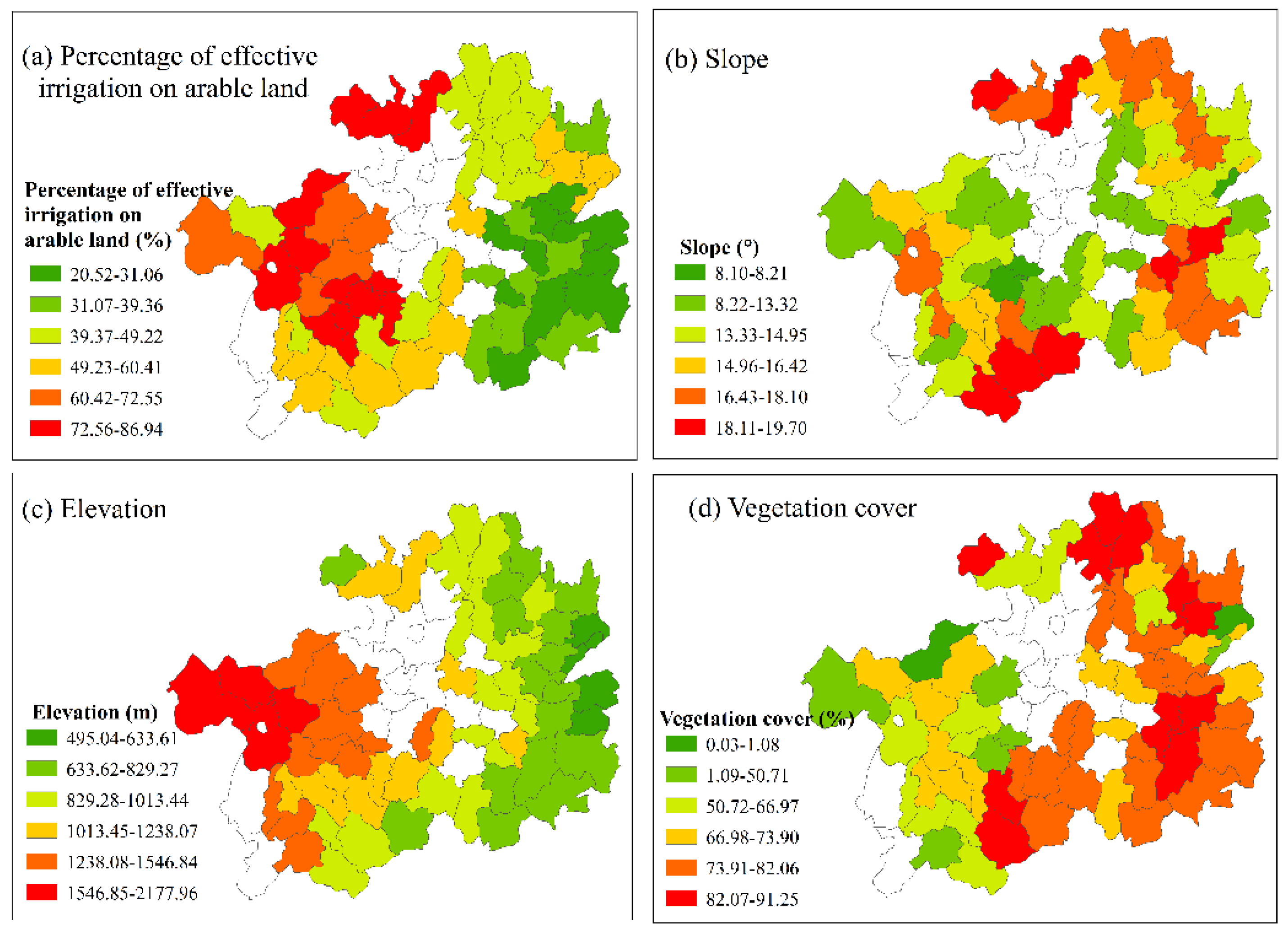
Percentage of effective irrigation on arable land: The percentage of effective irrigation on arable land can be used as a measure of the degree of regional water conservation and the stability of agricultural production. It is also an important indicator that characterizes the drought resistance of cultivated land. Figure 8a shows that the percentage of effective irrigation on arable land is spatially distributed, with a smaller percentage in the south than the north. The southern regions also have a higher slope, so the irrigation facilities are not great because of the high cost of infrastructure construction, including water conservation. Water resources are also easily lost when irrigation is conducted. As a result, the incidence of poverty in this area is relatively high. The slope in the northern region is relatively low, which is an advantage in terms of constructing water conservation facilities. Thus, water use efficiency is high in this region, which benefits agricultural production and increases per capita income. Consequently, the incidence of poverty is relatively low.
Slope: Topographic slope is an important indicator that reflects topography and geomorphology of the area. It also has different effects on regional hydrothermal conditions, soil and biology, thus, affecting agricultural production and production methods and infrastructure, including transportation, which thereby affect the regional economic development. Figure 8b shows that the slope of the study area is high in the surrounding area and low in the center, consistent with the spatial distribution of the incidence of poverty (Figure 5). The eastern, western and southern regions of the study area have a large slope, which leads to poor agricultural production and output. The cost of infrastructure construction is also high and external communication is difficult, further limiting the income of local farmers. As a result, the incidence of poverty is high in this region. The central region of the study area has a low slope, so conditions for development are better and farmers have more channels to increase their income. Therefore, the incidence of poverty is lower.
Elevation: Elevation is detected as another important topographic indicator to rural poverty. Elevation reflects the land availability and quality of the cultivated land and thus indirectly affect the wealth creation in poor areas. Figure 8c shows that the spatial pattern of the elevation of the study area is high in the west and low in the east. Elevation is increased from east to west. However, the spatial distribution of the incidence of poverty is partially consistent with elevation (Figure 8), suggesting that this has impacts of other indicators on poverty. Generally, the spatial pattern of elevation is similar to the percentage of effective irrigation on arable land, indicating that elevation can affect agricultural production efficiency and thus affect local farmers’ income.
Vegetation cover: Vegetation cover is an important indicator that reflects forestry resources in a region and can also reflect the ecological environment of the region. Figure 8d shows that areas with high vegetation cover occupy most of the counties in the study area and counties with low vegetation cover are scattered in the central and northern regions. Though vegetation cover is higher in southern and eastern areas, it belongs to a typical karst landform, with extensive rocky desertification and low environmental carrying capacity. Hence, the restored grassland and woodland have poor stability and weak resilience. However, the construction of ecological projects, including natural forest protection and shelterbelt construction, is emphasized in these areas, which limits the development of forest land resources. Overall, this type of resource cannot increase the income of local residents. As a result, the incidence of poverty is high in this region. The areas with less vegetation cover, in central and northern regions, have smaller slopes; hence, they can rely on their topographical advantages to develop the economy and raise income levels. Therefore, the incidence of poverty in these regions is relatively low.
From the above analysis, the topographic slope in the southeastern region of the study area is large and the percentage of effective irrigation on arable land is relatively low. These make agricultural production unstable and food production low; hence, it is difficult for farmers to increase their income. Despite the high degree of vegetation cover in this region, these resource advantages cannot be translated into economic advantages because of natural conditions and policy factors. As a result, the incidence of high–high poverty counties is concentrated in the southeast of the study area. In the northeastern part of the study area, although some counties have a high slope and are not suitable for large-scale crop production, the local area is an old revolutionary area. Therefore, tourism and other industries can be developed according to local characteristics and income-increasing channels can be expanded. Therefore, areas with incidences of low–low poverty are distributed in the northeast.
3.2.2. Interaction Effects of the Dominant Factors on the Incidence of Poverty
Table 3 illustrates the two-factor interaction effects on the incidence of poverty. These results suggest that the interactive effect is greater than the importance of a single factor and the interaction of each factor is that of non-linear enhancement. For example, slope non-linearly enhanced the effect of the percentage of effective irrigation on arable land (q = 0.77) on the incidence of poverty.
4. Discussion
4.1. Effects of the Geo-Environment on Poverty
The geo-environment significantly impacts the economic development of a region, particularly for primary industries [59,60,61]. According to the 2012 China Statistical Yearbook, poverty-stricken counties have a small amount arable land and a high proportion of their GDP is derived from primary industries. Therefore, agriculture is vital to the development of poverty-stricken areas and the development of agriculture depends heavily on the local geo-environment. Thus, the geo-environment is the most fundamental factor [62].
We found that the percentage of effective irrigation on arable land, topographic slope, elevation and vegetation cover are the dominant factors that affect the spatial pattern of poverty in the study area. This is consistent with a previous study, but the difference is that the previous study considered socio-economic factors [43]. Studies of factors that affect rural poverty have also demonstrated that the slope and agricultural water resources (irrigation and water consumption per acre) both contribute to rural poverty. Similar to slope, elevation is another important topographic indicator that reflects the land availability and quality of the cultivated land and thus indirectly affect the income of local farmers in the study area. In addition, the impact of vegetation cover on poverty varies from region-to-region. Guizhou Province is located in typical Karst areas with rocky desertification and serious soil erosion problem [13]. Vegetation plays an important role in this region and provides natural resources, ecosystem services and basic living conditions for local people [36]. The fraction of vegetation cover (e.g., forest and woodland) derived from satellite image was found associated with poverty [63]. In addition, income from woodland and non-timber forest products can contribute a large share of total household income [18]. These studies did not consider the impact of two-factor interactions on poverty, but we found that when the slope, percentage of effective irrigation on arable land and vegetation cover interact, the impact on the incidence of poverty is greater than the impact of individual factors. In particular, when the slope and percentage of effective irrigation on arable land interact, the q value is 0.77. Slope and irrigation conditions are critical to agricultural production and development in poor areas depends on primary industries. Therefore, during agricultural production, it is necessary to adjust agricultural processes according to different slopes and to construct water conservation facilities.
4.2. Mechanisms of How Dominant Factors Influence the Spatial Pattern of Poverty
The mechanism of action of dominant factors on the spatial pattern of poverty in Guizhou Province is summarized, based on previous research on poverty and poverty alleviation [15]. The percentage of effective irrigation on arable land, topographic slope, elevation and vegetation cover produce different results through different pathways. The topographic slope affects planting methods and the levels of agricultural mechanization. The higher the slope, the fewer the arable land resources and this limits the development of large-scale agricultural production. The percentage of effective irrigation on arable land is closely related to water conservation and terrain. The cost of constructing water conservation facilities in areas with a complex topography is high and unfavorable irrigation conditions result in low agricultural output. Vegetation resources cannot be well used by local residents because the study area has a serious problem of rocky desertification and it is an ecological barrier of the Pearl River. Furthermore, there are interactions between dominant factors, for example, slope and irrigation interactions, which aggravate their impact on agricultural development. Because of the different ways and effects of these factors on poverty, it leads to spatial patterns of poverty in Guizhou Province. If poverty is influenced by a single dominant factor, then its mechanism can easily be delineated [64,65,66,67]. However, in reality, the occurrence of poverty is often the result of a variety of factors; thus, it is necessary to pay attention to the combination of different measures to implement a comprehensive policy of poverty alleviation.
4.3. Implications for Policies for Poverty Alleviation
Poverty exhibits a clear spatial pattern and a universal policy for the alleviation of poverty has certain limitations. Therefore, it is necessary to implement measures to alleviate poverty tailored to local conditions. Because of the observed spatial pattern of the incidence of poverty in Guizhou Province and the analysis of the dominant factors, we offer the following recommendations:
Because of the spatial pattern of the incidence of poverty in Guizhou Province, it is necessary to implement measures to alleviate poverty tailored to local conditions. The spatial pattern indicates that the degree of poverty in the south is higher than in the north, mainly because the rocky desertification area is large, the soil is barren and the carrying capacity of resources and the environment is low in the south. Therefore, it is necessary to strengthen the construction of water storage and irrigation facilities to control the effect of rocky desertification. Furthermore, implementation of an ecological compensation mechanism and the transformation of ecological benefits into economic benefits, are required to alleviate poverty. Additionally, a relocation policy should be implemented for areas that are not suitable for human habitation and development. For the northern regions with a low incidence of poverty, the overall strategies for the alleviation of poverty are similar to those of targeted poverty alleviation: development of production and institution buildings, including strengthening infrastructure construction, improving the social security system and developing characteristic industries.
The findings in this study demonstrate that the percentage of effective irrigation on arable land, topographic slope, elevation and vegetation cover are the dominant factors that affect the spatial pattern of poverty. Therefore, in the process of alleviating poverty and economic development, we should pay attention to the impact of such factors. Based on the poverty scenario revealed in the study area, first, agricultural structures should be optimized and land use patterns should be converted, according to different degrees of slope, to prevent soil erosion. Additionally, it is necessary to strengthen the construction of water storage facilities, speed-up the construction of field irrigation projects and improve the utilization efficiency of karst groundwater. Moreover, strengthening the protection of vegetation, guiding the intensive use of forest land, implementing a strict management system for land use, improving the ecological compensation mechanism and adding public welfare posts, such as forest protection gardens, are necessary. Finally, considering that the impact of the interaction of factors on the incidence of poverty will be deepened, it is necessary to focus on matching different measures to alleviate poverty in order to improve the effectiveness of poverty alleviation.
4.4. Limitations
Although this study has examined the impact of the geo-environment on the spatial pattern of poverty, it was based on county-level administrative units. Future research could adopt finer scales (e.g., towns or villages) and provide a theoretical basis for the formulation of poverty alleviation measures across multiple scales. Additionally, geo-environmental and socioeconomic factors are the most direct factors affecting poverty, but geo-environmental factors play a restrictive role in the distribution of economic factors, to a certain extent. Some studies examined the impacts of types of crops (legume and cereal crop) [68], type of property (value of farm equipment) [69], aridity on rural poverty [70]. However, these variables are not available in this study. Future study could obtain these data from household survey and collect more climatic information (e.g., aridity) to improve analyses. In the future, studies should consider to what extent the development of poverty-stricken areas can overcome the limitations of the geo-environment and how the geo-environment can be used for its potential economic value while protecting the ecological environment, thereby changing the impact of the geo-environment on poverty.
5. Conclusions
In this study, spatial autocorrelation was used to explore spatial patterns of poverty. The dominant factors explaining the incidence of poverty were identified using a geo-detector model. Based on this analysis, we draw the following conclusions: (1) The incidence of poverty in the study area was larger in the south than the north and larger in eastern and western regions compared to the central region. (2) County-level incidences of poverty exhibited a strong positive spatial autocorrelation. Areas of high–high incidences of poverty were concentrated in the southwest of Guizhou Province and areas of low–low incidences of poverty were mainly in the northeast. (3) Percentage of effective irrigation on arable land, topographic slope, elevation and vegetation cover, were the dominant factors that explained the spatial pattern of poverty in the study area. The influence of two-factor interactions on the incidence of poverty was greater than the influence of each individual factor. Based on these results, countermeasures and suggestions for targeted poverty alleviation were proposed, providing important and significant reference for implementing a poverty alleviation strategy in other poverty-stricken areas in China.
Author Contributions
Conceptualization, Yong Ge; methodology, Yangyang Fu; software, Yangyang Fu; validation, Yangyang Fu and Zhoupeng Ren; formal analysis, Yangyang Fu and Zhoupeng Ren; investigation, Yong Ge, Zhoupeng Ren and Yangyang Fu; resources, Yong Ge; data curation, Yangyang Fu; writing—original draft preparation, Yong Ge, Zhoupeng Ren and Yangyang Fu; writing—review and editing, Yong Ge, Zhoupeng Ren and Yangyang Fu; visualization, Yangyang Fu; supervision, Yong Ge; project administration, Yong Ge; funding acquisition, Yong Ge. All authors have read and agreed to the published version of the manuscript.
Funding
This study was supported by National Key Research and Development Program (No.2017YFB0503501) and the National Natural Science Foundation for Distinguished Young Scholars of China (No. 41725006).
Institutional Review Board Statement
Not applicable.
Informed Consent Statement
Not applicable.
Data Availability Statement
Not applicable.
Acknowledgments
Thanks to the website http://www.resdc.cn for providing the free data.
Conflicts of Interest
The authors declare no conflict of interest.
References
- Haushofer, J.; Fehr, E. On the psychology of poverty. Science 2014, 344, 862–867. [Google Scholar] [CrossRef]
- Tollefson, J. Can randomized trials eliminate global poverty? Nat. News 2015, 524, 150. [Google Scholar] [CrossRef] [Green Version]
- Steele, J.; Sundsøy, P.; Pezzulo, C.; Alegana, V.; Bird, T.; Blumenstock, J.; Bjelland, J.; Monsen, K.; Montjoye, Y.; Iqbal, A.; et al. Mapping poverty using mobile phone and satellite data. J. R. Soc. Interface 2017, 14, 20160690. [Google Scholar] [CrossRef]
- Guo, Y.; Zhou, Y.; Liu, Y. Targeted poverty alleviation and its practices in rural China: A case study of Fuping county, Hebei Province. J. Rural Stud. 2019. [Google Scholar] [CrossRef]
- Ravallion, M. Are there lessons for Africa from China’s success against poverty? World Dev. 2009, 37, 303–313. [Google Scholar] [CrossRef] [Green Version]
- Liu, H. Study on Implementation of Targeted Poverty Alleviation and Regional Coordinated Development. Bull. Chin. Acad. Sci. 2016, 31, 320–327. [Google Scholar]
- Wang, S.; Sun, J. China’s relative poverty standards, measurement and targeting after the completion of building a moderately prosperous society in an all-round way: An analysis based on data from China urban and rural household survey in 2018. Chin. Rural Econ. 2021, 3, 2–23. [Google Scholar]
- Du, G.M.; Feng, Y.; Yang, Y.Y. Study on Precision Poverty Alleviation Strategy Characteristics of Poverty Stricken Areas in Heilongjiang Province. Agric. Econ. Manag. 2016, 6, 5–14. [Google Scholar]
- Li, Y.; Long, H.; Liu, Y. Spatio-temporal pattern of China’s rural development: A rurality index perspective. J. Rural Stud. 2015, 38, 12–26. [Google Scholar] [CrossRef]
- Altmann, M.; Eisenreich, S.; Lehner, D.; Moser, S.; Neidl, T.; Rüscher, V.; Vogeler, T. Global inequality and poverty in perspectives of geography. Multicult. Educt. Technol. J. 2013, 7, 127–150. [Google Scholar] [CrossRef]
- Jalan, J.; Ravallion, M. Geographic poverty traps? A micro model of consumption growth in rural China. J. Appl. Econom. 2002, 17, 329–346. [Google Scholar] [CrossRef] [Green Version]
- Kanbur, R.; Sumner, A. Poor countries or poor people? Development assistance and the new geography of global poverty. J. Int. Dev. 2012, 24, 686–695. [Google Scholar] [CrossRef] [Green Version]
- Zhou, Y.; Li, Y.; Liu, Y. The nexus between regional eco-environmental degradation and rural impoverishment in China. Habitat Int. 2020, 96, 102086. [Google Scholar] [CrossRef]
- Okwi, P.; Ndeng’e, G.; Kristjanson, P.; Arunga, M.; Notenbaert, A.; Omolo, A.; Henninger, N.; Benson, T.; Kariuki, P.; Owuor, J. Spatial determinants of poverty in rural Kenya. Proc. Natl. Acad. Sci. USA 2007, 104, 16769–16774. [Google Scholar] [CrossRef] [PubMed] [Green Version]
- Xu, Z.; Cai, Z.; Wu, S.; Huang, X.; Liu, J.; Sun, J.; Su, S.; Weng, M. Identifying the Geographic Indicators of Poverty Using Geographically Weighted Regression: A Case Study from Qiandongnan Miao and Dong Autonomous Prefecture, Guizhou, China. Soc. Indic. Res. 2019, 142, 947–970. [Google Scholar] [CrossRef]
- Imran, M.; Stein, A.; Zurita-Milla, R. Investigating rural poverty and marginality in Burkina Faso using remote sensing-based products. Int. J. Appl. Earth Obs. Geoinf. 2014, 26, 322–334. [Google Scholar] [CrossRef]
- Watmough, G.; Atkinson, P.; Hutton, C. Predicting socioeconomic conditions from satellite sensor data in rural developing countries: A case study using female literacy in Assam, India. Appl. Geogr. 2013, 44, 192–200. [Google Scholar] [CrossRef]
- Babulo, B.; Muys, B.; Nega, F.; Tollens, E.; Nyssen, J.; Deckers, J.; Mathijs, E. The economic contribution of forest resource use to rural livelihoods in Tigray, Northern Ethiopia. For. Policy Econ. 2009, 11, 109–117. [Google Scholar] [CrossRef]
- Liu, J.; Zou, C.; Gao, J.; Ma, S.; Wang, W.; Wu, K.; Liu, Y.; Xu, D.; Xu, M.; You, G. Location determination of ecologically vulnerable regions in China. Biodivers. Sci. 2015, 23, 725–732. [Google Scholar] [CrossRef] [Green Version]
- Olivia, S.; Gibson, J.; Rozelle, S.; Huang, J.; Deng, X. Mapping poverty in rural China: How much does the environment matter? Environ. Dev. Econ. 2011, 16, 129–153. [Google Scholar] [CrossRef] [Green Version]
- Kassa, G.; Teferi, B.; Delelegn, N. The poverty-Environment nexus in developing countries: Evidence from Ethiopia: A systematic review. Asian J. Agric. Ext. Econ. Sociol. 2018, 24, 1–13. [Google Scholar] [CrossRef]
- Barbier, E.; Hochard, J. Land degradation and poverty. Nat. Sustain. 2018, 1, 623–631. [Google Scholar] [CrossRef]
- Angelsen, A.; Jagger, P.; Babigumira, R.; Belcher, B.; Hogarth, N.; Bauch, S.; Börner, J.; Hall, C.; Wunder, S. Environmental income and rural livelihoods: A global-comparative analysis. World Dev. 2014, 64, S12–S28. [Google Scholar] [CrossRef] [Green Version]
- Schleicher, J.; Schaafsma, M.; Burgess, N.; Sandbrook, C.; Danks, F.; Cowie, C.; Vira, B. Poorer without it? The neglected role of the natural environment in poverty and wellbeing. Sustain. Dev. 2018, 26, 83–98. [Google Scholar] [CrossRef] [Green Version]
- Asfaw, S.; Scognamillo, A.; Caprera, G.; Sitko, N.; Ignaciuk, A. Heterogeneous impact of livelihood diversification on household welfare: Cross-country evidence from Sub-Saharan Africa. World Dev. 2019, 117, 278–295. [Google Scholar] [CrossRef]
- Watts, M.J.; Bohle, H.G. The space of vulnerability: The causal structure of hunger and famine. Prog. Hum. Geogr. 1993, 17, 43–67. [Google Scholar] [CrossRef]
- Hua, X.; Yan, J.; Zhang, Y. Evaluating the role of livelihood assets in suitable livelihood strategies: Protocol for anti-poverty policy in the Eastern Tibetan Plateau, China. Ecol. Indic. 2017, 78, 62–74. [Google Scholar] [CrossRef]
- Cao, S.; Wang, Y.; Duan, F.; Zhao, W. Coupling between ecological vulnerability and economic poverty in contiguous destitute areas, China: Empirical analysis of 714 poverty-stricken counties. Chin. J. Appl. Ecol. 2016, 27, 2614–2622. [Google Scholar]
- Gray, L.C.; Moseley, W.G. A geographical perspective on poverty–environment interactions. Geogr. J. 2005, 171, 9–23. [Google Scholar] [CrossRef]
- Ward, P. Transient poverty, poverty dynamics, and vulnerability to poverty: An empirical analysis using a balanced panel from rural China. World Dev. 2016, 78, 541–553. [Google Scholar] [CrossRef] [Green Version]
- Han, Z. Fragility and rural poverty. Probl. Agric. Econ. 2004, 10, 103–110. [Google Scholar]
- Jalan, J.; Ravallion, M. Behavioral responses to risk in rural China. J. Dev. Econ. 2001, 66, 23–49. [Google Scholar] [CrossRef] [Green Version]
- Zhou, Y.; Guo, Y.; Liu, Y. Comprehensive measurement of county poverty and anti-poverty targeting after 2020 in China. Acta Geogr. Sin. 2018, 73, 1478–1493. [Google Scholar]
- Ren, Z.; Ge, Y.; Wang, J.; Mao, J.; Zhang, Q. Understanding the inconsistent relationships between socioeconomic factors and poverty incidence across contiguous poverty-stricken regions in China: Multilevel modelling. Spat. Stat. 2017, 21, 406–420. [Google Scholar] [CrossRef]
- Curtis, K.; Lee, J.; O’Connell, H.; Zhu, J. The spatial distribution of poverty and the long reach of the industrial makeup of places: New evidence on spatial and temporal regimes. Rural Sociol. 2019, 84, 28–65. [Google Scholar] [CrossRef] [Green Version]
- Watmough, G.; Atkinson, P.; Hutton, C. Exploring the links between census and environment using remotely sensed satellite sensor imagery. J. Land Use Sci. 2013, 8, 284–303. [Google Scholar] [CrossRef]
- Liu, M.; Hu, S.; Ge, Y.; Heuvelink, G.; Ren, Z.; Huang, X. Using multiple linear regression and random forests to identify spatial poverty determinants in rural China. Spat. Stat. 2020, 42, 100461. [Google Scholar] [CrossRef]
- Farrow, A.; Larrea, C.; Hyman, G.; Lema, G. Exploring the spatial variation of food poverty in Ecuador. Food Policy 2005, 30, 510–531. [Google Scholar] [CrossRef] [Green Version]
- Vaziri, M.; Acheampong, M.; Downs, J.; Majid, M. Poverty as a function of space: Understanding the spatial configuration of poverty in Malaysia for Sustainable Development Goal number one. GeoJournal 2019, 84, 1317–1336. [Google Scholar] [CrossRef]
- Wang, J.; Li, X.; Christakos, G.; Liao, Y.; Zhang, T.; Gu, X.; Zheng, X. Geographical detectors-based health risk assessment and its application in the neural tube defects study of the Heshun Region, China. Int. J. Geogr. Inf. Sci. 2010, 24, 107–127. [Google Scholar] [CrossRef]
- Wang, J.; Hu, Y. Environmental health risk detection with GeogDetector. Environ. Model. Softw. 2012, 33, 114–115. [Google Scholar] [CrossRef]
- Wang, J.; Zhang, T.; Fu, B. A measure of spatial stratified heterogeneity. Ecol. Indic. 2016, 67, 250–256. [Google Scholar] [CrossRef]
- Wang, Y.; Liu, J.; Tu, Y. Classification of ecological environment vulnerability of typical karst county in Guizhou. Carsol. Sin. 2002, 21, 221–225. [Google Scholar]
- Zeng, Y.; Xu, C. Analysis on influential factors of poverty in contiguous destitute areas in Guizhou Province. World Reg. Stud. 2017, 26, 158–167. [Google Scholar]
- Ravallion, M.; Chen, S. China’s (uneven) progress against poverty. J. Dev. Econ. 2007, 82, 1–42. [Google Scholar] [CrossRef] [Green Version]
- Bigman, D.; Fofack, H. Geographical targeting for poverty alleviation: An introduction to the special issue. World Bank Econ. Rev. 2000, 14, 129–145. [Google Scholar] [CrossRef]
- Ma, Z.; Chen, X.; Chen, H. Multi-scale Spatial Patterns and Influencing Factors of Rural Poverty: A Case Study in the Liupan Mountain Region, Gansu Province, China. Chin. Geogr. Sci. 2018, 28, 296–312. [Google Scholar] [CrossRef] [Green Version]
- Zhou, Y.; Liu, Y. The geography of poverty: Review and research prospects. J. Rural Stud. 2019. [Google Scholar] [CrossRef]
- Liu, Y.; Xu, Y. A geographic identification of multidimensional poverty in rural China under the framework of sustainable livelihoods analysis. Appl. Geogr. 2016, 73, 62–76. [Google Scholar] [CrossRef]
- Lv, C.; Lan, X.; Sun, W. A study on the Relationship between natural factors and population distribution in Beijing using Geographical Detector. J. Nat. Resour. 2017, 32, 1385–1397. [Google Scholar]
- Qu, W.; Tu, Q.; Niu, S.; Hu, M. Poverty effect test of natural geographical environment-An Empirical Analysis of the Influence of Physical Geography on Rural Poverty. Chin. Rural Econ. 2012, 2, 21–34. [Google Scholar]
- Cheng, X.; Shuai, C.; Wang, J.; Li, W.; Shuai, J.; Liu, Y. Building a sustainable development model for China’s poverty-stricken reservoir regions based on system dynamics. J. Clean. Prod. 2018, 176, 535–554. [Google Scholar] [CrossRef]
- Hutchinson, M. Interpolation of rainfall data with Thin Plate Smoothing Splines-Part I: Two dimensional smoothing of data with short range correlation. J. Geogr. Inf. Decis. Anal. 1998, 2, 139–151. [Google Scholar]
- Ge, Y.; Hu, S.; Ren, Z.; Jia, Y.; Wang, J.; Liu, M.; Zhang, D.; Zhao, W.; Luo, Y.; Fu, Y.; et al. Mapping annual land use changes in China’s poverty-stricken areas from 2013–2018. Remote Sens. Environ. 2019, 232, 111285. [Google Scholar] [CrossRef]
- Tiefelsdorf, M. Some practical applications of Moran’s I’s exact conditional distribution. Pap. Reg. Sci. 1998, 77, 101–129. [Google Scholar] [CrossRef]
- Tobler, W. A computer movie simulating urban growth in the Detroit region. Econ. Geogr. 1970, 46, 234–240. [Google Scholar] [CrossRef]
- Wu, P.; Li, T.; Li, W. Spatial differentiation and influencing factors analysis of rural poverty at county scale: A case study of Shanyang county in Shaanxi province, China. Geogr. Res. 2018, 37, 3. [Google Scholar]
- Anselin, L. Local indicators of spatial association-LISA. Geogr. Anal. 1995, 27, 93–115. [Google Scholar] [CrossRef]
- Deng, W.; Tang, W. General directions and countermeasures for urbanization development in mountain areas of China. J. Mt. Sci. 2013, 31, 168–173. [Google Scholar]
- Husmann, C. Marginality as a root cause of poverty: Identifying marginality hotspots in Ethiopia. World Dev. 2016, 78, 420–435. [Google Scholar] [CrossRef]
- Wishitemi, B.; Momanyi, S.; Ombati, B.; Okello, M. The link between poverty, environment and ecotourism development in areas adjacent to Maasai Mara and Amboseli protected areas, Kenya. Tour. Manag. Perspect. 2015, 16, 306–317. [Google Scholar] [CrossRef]
- Zhou, L.; Xiong, L. Natural topographic controls on the spatial distribution of poverty-stricken counties in China. Appl. Geogr. 2018, 90, 282–292. [Google Scholar] [CrossRef]
- Watmough, G.; Marcinko, C.; Sullivan, C.; Tschirhart, K.; Mutuo, P.; Palm, C.; Svenning, J. Socioecologically informed use of remote sensing data to predict rural household poverty. Proc. Natl. Acad. Sci. USA 2019, 116, 1213–1218. [Google Scholar] [CrossRef] [Green Version]
- Liu, Y.; Li, J. Geographic detection and optimizing decision of the differentiation mechanism of rural poverty in China. Acta Geogr. Sin. 2017, 72, 161–173. [Google Scholar]
- Li, Y.; Su, B.; Liu, Y. Realizing targeted poverty alleviation in China: people’s voices, implementation challenges and policy implications. China Agric. Econ. Rev. 2016, 8, 443–454. [Google Scholar] [CrossRef]
- Li, Y.; Cao, Z.; Zheng, X. Regional and sustainable approach for target-poverty alleviation and development of China. Bull. Chin. Acad. Sci. 2016, 31, 279–288. [Google Scholar]
- Yang, Y.; Liu, Y.; Zhang, Z. Study on Policy Innovation and Suggestions of Targeted Poverty Alleviation Based on Typical Investigation. Bull. Chin. Acad. Sci. 2016, 3, 337–345. [Google Scholar]
- Makate, C.; Wang, R.; Makate, M.; Mango, N. Crop diversification and livelihoods of smallholder farmers in Zimbabwe: Adaptive management for environmental change. SpringerPlus 2016, 5, 1135–1153. [Google Scholar] [CrossRef] [PubMed] [Green Version]
- Grootaert, C. The determinants of poverty in Côte d’Ivoire in the 1980s. J. Afr. Econ. 1997, 6, 169–196. [Google Scholar] [CrossRef]
- Azzarri, C.; Signorelli, S. Climate and poverty in Africa South of the Sahara. World Dev. 2020, 125, 104691. [Google Scholar] [CrossRef]
Figure 1.
Location of the study area. (a) Spatial distribution of poverty-stricken areas. (b) Location of Guizhou Province and its neighboring poverty-stricken areas.
Figure 1.
Location of the study area. (a) Spatial distribution of poverty-stricken areas. (b) Location of Guizhou Province and its neighboring poverty-stricken areas.

Figure 2.
Spatial distribution of county-level per capita annual net income.

Figure 3.
Spatial distribution of terrain relief within each county.
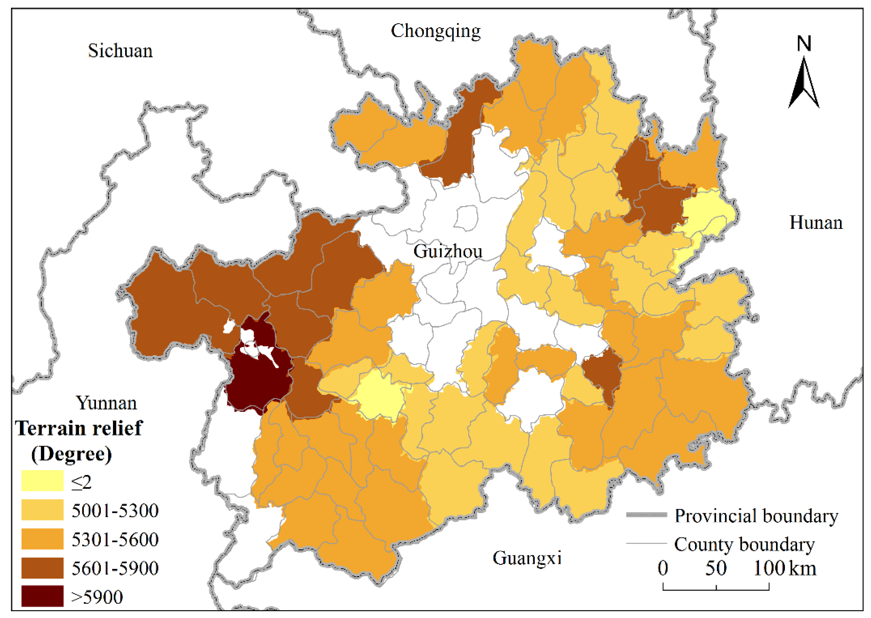
Figure 4.
Spatial distribution of main road within study area.
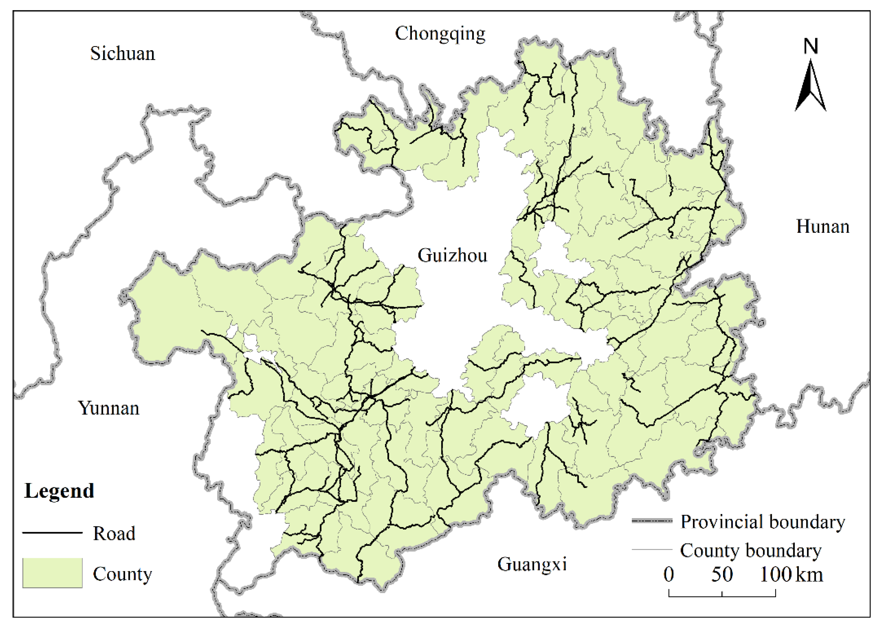
Figure 5.
Spatial distribution of county-level poverty incidence in Guizhou Province in 2013.

Figure 6.
Local autocorrelation of county-level poverty incidence in Guizhou Province.
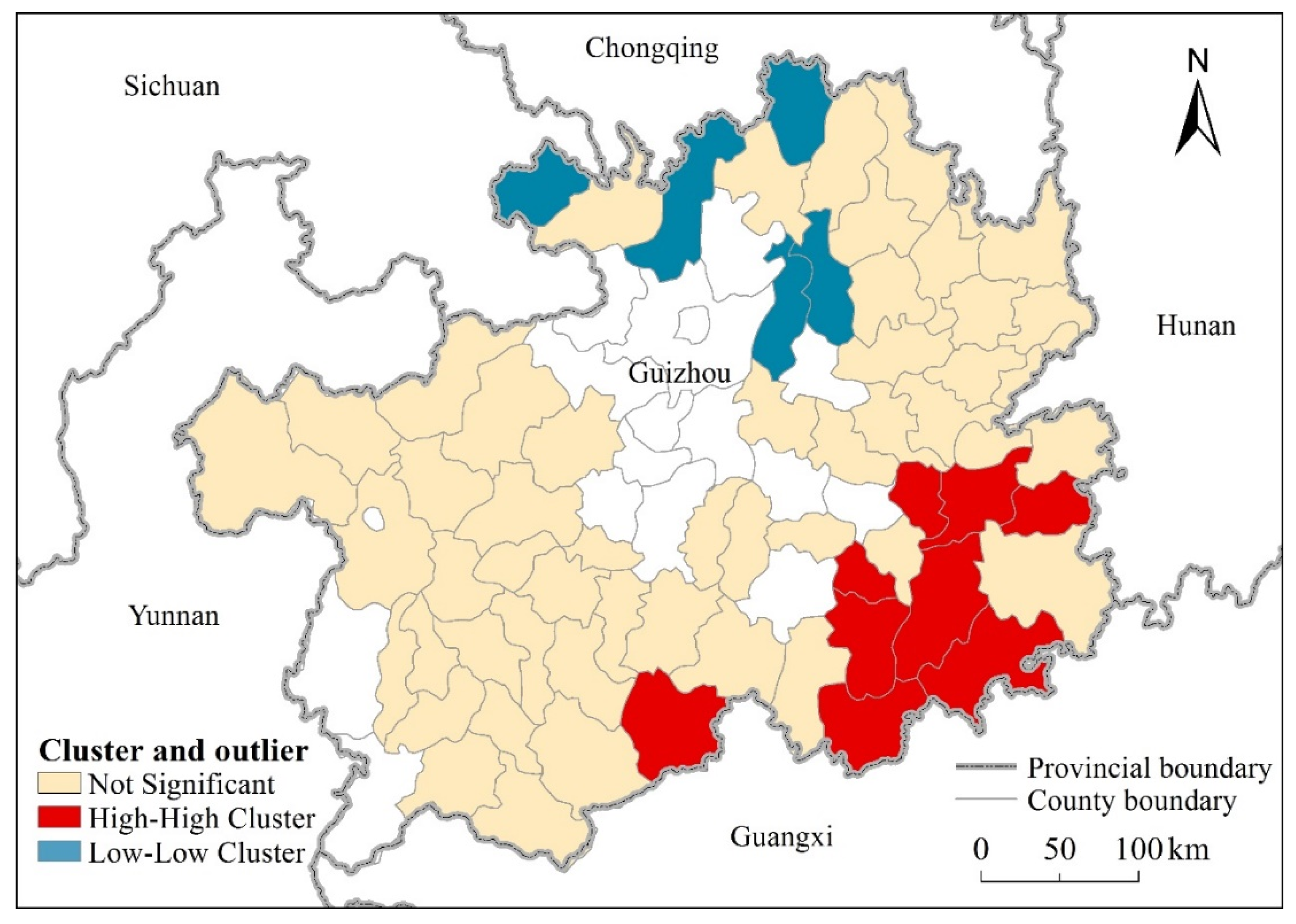
Figure 7.
Factor detector on the poverty incidence. Note: irr: percentage of effective irrigation on arable land; slo: slope; ele: elevation; veg: vegetation cover; tem: annual average temperature; pre: annual average precipitation; riv: river density; ter: terrain relief; ara: per capita arable land area.

Figure 8.
Distribution of dominant factors in Guizhou Province: (a) percentage of effective irrigation on arable land; (b) slope; (c) elevation; (d) vegetation cover. The graduation of the legends is consistent with discretization results of original explanatory variables.
Figure 8.
Distribution of dominant factors in Guizhou Province: (a) percentage of effective irrigation on arable land; (b) slope; (c) elevation; (d) vegetation cover. The graduation of the legends is consistent with discretization results of original explanatory variables.


Table 1.
Description of geo-environmental covariates.
| Topography | Climate | Water Resources | Land Use |
|---|---|---|---|
| Elevation | Annual average temperature | River density | Vegetation cover |
| Slope | Annual average precipitation | Per capita arable land area | |
| Terrain relief | Percentage of effective irrigation on arable land |
Table 2.
Types of interaction between two covariates.
| Graphical Representation | Description | Interaction |
|---|---|---|
 | q(xa ∩ xb) < Min(q(xa), q(xb)) | Weaken, nonlinear |
 | Min(q(xa), q(xb)) < q(xa ∩ xb) < Max(q(xa), q(xb)) | Weaken, univaraite |
 | q(xa ∩ xb) > Max(q(xa), q(xb)) | Enhance, bivariate |
 | q(xa ∩ xb) = q(xa) + q(xb) | Independent |
 | q(xa ∩ xb) > q(xa) + q(xb) | Enhance, nonlinear |
Note: ![Ijgi 10 00270 i006]() Min(q(xa), q(xb));
Min(q(xa), q(xb)); ![Ijgi 10 00270 i007]() Max(q(xa), q(xb));
Max(q(xa), q(xb)); ![Ijgi 10 00270 i008]() q(xa) + q(xb);
q(xa) + q(xb); ![Ijgi 10 00270 i009]() q(xa ∩ xb).
q(xa ∩ xb).
 Min(q(xa), q(xb));
  Max(q(xa), q(xb));
  q(xa) + q(xb);
  q(xa ∩ xb).
Table 3.
Interaction effects of dominant factors on poverty incidence.
| xa ∩ xb | q Value | Description | Interaction |
|---|---|---|---|
| slope ∩ irrigation | 0.77 | q(slope ∩ irrigation) > q(slope) + q(irrigation) | Enhance, nonlinear |
| slope ∩ vegetation | 0.44 | q(slope ∩ vegetation) > q(slope) + q(vegetation) | Enhance, nonlinear |
| irrigation ∩ vegetation | 0.62 | q(irrigation ∩ vegetation) > q(irrigation) + q(vegetation) | Enhance, nonlinear |
Publisher’s Note: MDPI stays neutral with regard to jurisdictional claims in published maps and institutional affiliations. |
© 2021 by the authors. Licensee MDPI, Basel, Switzerland. This article is an open access article distributed under the terms and conditions of the Creative Commons Attribution (CC BY) license (https://creativecommons.org/licenses/by/4.0/).
Share and Cite
MDPI and ACS Style
Ge, Y.; Ren, Z.; Fu, Y. Understanding the Relationship between Dominant Geo-Environmental Factors and Rural Poverty in Guizhou, China. ISPRS Int. J. Geo-Inf. 2021, 10, 270. https://doi.org/10.3390/ijgi10050270
AMA Style
Ge Y, Ren Z, Fu Y. Understanding the Relationship between Dominant Geo-Environmental Factors and Rural Poverty in Guizhou, China. ISPRS International Journal of Geo-Information. 2021; 10(5):270. https://doi.org/10.3390/ijgi10050270
Chicago/Turabian StyleGe, Yong, Zhoupeng Ren, and Yangyang Fu. 2021. "Understanding the Relationship between Dominant Geo-Environmental Factors and Rural Poverty in Guizhou, China" ISPRS International Journal of Geo-Information 10, no. 5: 270. https://doi.org/10.3390/ijgi10050270
Note that from the first issue of 2016, this journal uses article numbers instead of page numbers. See further details here.