
Strategic Analysis for Governance Development of National Spatial Data Infrastructure Portal in Korea


Smart Cities Research Cluster, Department of Future & Smart Construction Research, Korea Institute of Civil Engineering and Building Technology, Suwon City 10223, Korea
*
Author to whom correspondence should be addressed.
ISPRS Int. J. Geo-Inf. 2021, 10(10), 654; https://doi.org/10.3390/ijgi10100654
Submission received: 3 August 2021
/
Revised: 19 September 2021
/
Accepted: 22 September 2021
/
Published: 28 September 2021
Abstract
:The Korean government released the National Spatial Data Infrastructure Portal (NSDIP) by integrating the spatial information possessed by 205 agencies to implement governance through the portal. In this study, four evaluation criteria groups (disclosure, participation, civil petition service, and website usability) were established through a literature review related to governance and government portals. After evaluation based on the four evaluation criteria, governance improvement measures were suggested. As an improvement measure, in terms of information disclosure, it was necessary to manage the quality of data update cycle, accuracy, metadata, etc., and to provide customized spatial information. In the stakeholder participation section, feedback from users is reflected in policies, and activation of participation spaces through education and exhibitions is required. In terms of civil petition service, it is necessary to introduce an incentive system to improve innovative services and to prepare measures to prevent infringement of security and privacy in the civil petition process. In website usability, it is necessary to prepare an improvement plan by introducing user-friendly interface design using GIS viewer, and statistics and GIS spatial analysis functions. The improvement plan by the evaluation criteria is expected to be the direction to implement inclusive portal governance.
1. Introduction
The Korean government has announced a strategy to upgrade the national portal to provide innovative spatial information service to the public [1]. This is because citizens want to actively participate in government administration, and they want to be provided with various spatial information owned by the government. In addition, to strengthen national competitiveness by enhancing the efficiency of the government, the government portal also has the advantage of enhancing the value of public services by expanding interactive communication with the public [2]. In the government portal, the role of governance through which stakeholders can communicate and cooperate has recently become important. Governance refers to a democratic social foundation in which the state, local government, corporations, and citizens create a mutually cooperative system and communicate voluntarily [3]. Therefore, the government and citizens do not necessarily have to provide unilaterally considerable administrative spatial information but rather governance cooperation to collaborate and communicate with each other. The governance portal allows all participants to create value through social communication among stakeholders [4,5]. In the field of spatial information as well, it was necessary to establish a governance system due to lack of communication, redundancy, and lack of a cooperation system. The establishment of a governance portal for the integration and disclosure of large amounts of spatial information was emphasized [6,7,8,9]. Spatial information refers to geographical data on all objects existing on the earth and is used as important data for constructing a GIS (Geographic Information System) used for various decision-making for national administration [10]. In addition, spatial information is being used in industries that create a variety of high added values by fusion with technologies that lead the fourth industrial revolution, such as artificial intelligence, digital twins, smart cities, augmented reality, autonomous vehicles, and drones [11]. The amount of spatial information increases very rapidly and the speed of convergence with various social media data is also rapidly accelerating. According to these trends, the concept of ‘spatial information web portals’ or ‘geoportals’ has also developed as one of the core solutions for accessing and sharing spatial information [7,12].
In this respect, the Korean government unified the spatial information held by each central ministry and launched the service through the NSDIP [1]. The NSDIP, built to open the spatial information held by the government, should play an important role in creating new added value through cooperation between the government, companies, and citizens. From that point of view, there is a need to establish a sustainable development strategy by analyzing what are the problems and what are the measures to improve it in order for NSDIP to play a governance role. Therefore, the purpose of this study was to analyze the governance function of NSDIP and to conduct a strategic analysis to establish a sustainable development strategy. For this purpose, the methodology of this study is qualitative research based on the interpretivism research paradigm [13]. Key words were extracted through a literature review on the core features required for the spatial information government portal to implement governance. Then, key words were classified into four feature groups, and these groups were used as the evaluation criteria. After evaluating the NSDIP according to the evaluation criteria, governance improvement plans were presented (Figure 1). These improvement plans are expected to contribute to creating high added value by providing innovative services and developing creative spatial information products through cooperation between stakeholders.
2. Literature Review
2.1. NSDIP and Governance
Governance is a set of systemic processes in which stakeholders cooperate and communicate to solve problems [14,15,16]. In other words, in governance, the government induces citizen participation in the decision-making process, improves service quality, and uses information and communication technology for transparent policy achievement [17,18]. Governance is a mutually cooperative system that emerged as the boundaries between public and private organizations collapsed in a broad sense. In a narrow sense, governance is a voluntary participatory act within the sphere of civil society [3]. Recently, interest has been focused on portal governance, in which participants connect and derive creativity [4,19,20,21]. Users can exchange desired goods or services with each other through the portal, allowing all participants to create value. The fast rise of the platform is because as the network effect increases due to the development of Information and Communications Technology (ICT), smooth communication and information exchange between users and suppliers are necessary [21]. From this point of view, as a government portal, the NSDIP can improve the flexibility, democracy, and participation level of network governance. That is, the relationship between the government and users is made equal, and smooth communication is achieved through ICT technology. The use of portals also allows the public to more easily express and propose their opinions. Thus, the portals can serve as an element that can enhance citizen participation for the development of spatial information and problem solving and increase the acceptance of policy decisions [22,23]. In addition, the government’s use of portals improves the efficiency of public service delivery methods, enables rapid identification and response to public needs, and secures transparency and reliability from the public through information disclosure.
The Korean government established the National Geographic Information System Phase 1 Basic Plan in 1995 and promoted the GIS development project at the national level. Therefore, the sixth basic plan (2018–2022) must produce open spatial information so that anyone can use it conveniently. In addition, the goal of realizing smart national management was set as a policy decision. That is, high-quality jobs were created, and spatial information was merged by creating an open spatial information convergence ecosystem [1]. In other words, in the sixth step basic plan, user-centered spatial information opening, two-way communication through spatial information sharing, and the establishment of a cooperative spatial information governance system were decided as the promotion strategy, and the project was launched in 2018. In consideration of the characteristics of creating the value of spatial information through convergence and use, setting a spatial information governance system has become more necessary to reinforce the cooperation system among stakeholders. The Korean government established the NSDIP (http://www.nsdi.go.kr/lxportal/?menuno=2679, accessed on 4 September 2021) as a portal to collect and supply spatial information held by 205 agencies, including central ministries, local governments, and public institutions. A total of 67,278 datasets of spatial information were released this time, including land management and regional development (50.4%), road, transportation, and logistics (17.0%), general administration (9.2%), and map-related fields (8.6%). Spatial information will be used in connection with most technologies that lead the fourth industrial revolution, such as digital twins, smart cities, augmented reality, autonomous vehicles, and drones, which have been attracting attention recently.
2.2. Spatial Information Web Portals
‘Spatial information web portals’ is used synonymously with ‘geoportals’ and is defined as a web-based gateway that connects to spatial data infrastructure [24]. The motivations for the development of geographic portals were initiated by scientific spatial information projects and applications, international and national organizations, and commercial purposes. This portal was promoted and built with aims to share spatial data from heterogeneous data sources. Examples include the Global Earth Observations System of Systems (GEOSS) portal developed by the Group on Earth Observations (GEO) and the Committee on Earth Observation Satellite (CEOS) [25]. Member states of these international organizations have often developed their own systems, including dedicated geoportals. In other words, China GEOSS, AmeriGEOSS, and EuroGEOSS can be considered as regional hubs of GEOSS. The World Data System (WDS) Data Portal is another example led by the International Council for Science (ICSU), which provides access to currently available metadata catalogs using international and community standards. Another example is the INSPIRE geoportal developed by the European Union (EU) in the context of the Infrastructure for Spatial Information in Europe (INSPIRE) directive. The INSPIRE geoportal provides access to spatial datasets related to 34 themes from 27 EU Member States [26]. The data provided by geoportals is a heterogeneous spatial dataset drawn from multiple data sources. Data such as volunteered geographical information, near real-time data, and digital terrain models (DTM) are also provided, and online geo-processing models can be implemented [27,28]. To provide a common standard for heterogeneous data, interoperability is guaranteed through data harmonization, and there are the federated approach and the brokered approach [29,30]. The most relevant standardization organizations in the geospatial domain are the Open Geospatial Consortium (OGC) and the International Organization for Standardization (ISO) [31,32]. OGC plays a key role in the sharing of spatial information on a global scale by providing open standard specifications that facilitate interoperability. The technical committee ISO/TC 211 is responsible for international standards for geographic information/geomatics. The four standards related to geoportals are ISO 19115 (metadata), ISO 19139 (XML schema implementation), ISO 19119 (services), and ISO 19157 (data quality).
3. Determination of Evaluation Criteria
This study’s subject of analysis is the national spatial information portal launched online by the Korean government. In addition, the data for analysis are provided by the NSDIP, the 6th Basic Plan for National Spatial Information Policy, reports, press releases, and academic papers. Regarding the analysis method, an evaluation model that can analyze the NSDIP based on the governance concept was developed through the literature review. The analysis contents are the types of spatial information provided by the NSDIP, disclosure methods, accessibility, government-local government–corporate–citizen participation, cooperation, civil petition service procedures, the convenience and efficiency of the web platform, etc. Therefore, the main features for NSDIP to play a governance role were investigated through the literature review.
3.1. Information Disclosure
Governance is implemented by increasing the accessibility of stakeholders to spatial information through the portal and providing various and accurate spatial information. Therefore, the portal should provide various spatial information owned by the state as customized information according to the user’s technical skills [4,5,7,8,9,26,27,33,34,35]. In addition, accurate and up-to-date information should be opened for easy access by users, and the government should increase the transparency and credibility of government administration while allowing corporations and citizens to share spatial information [22,26,33,34,35,36]. Since the users access information through the Internet, the portal has the convenience of not requiring the user to directly visit an administrative agency, and since information can be accessed through the Internet anytime and anywhere, it has the advantage of expanding the information user base [37].
3.2. Stakeholder Participation
Added value is created through participation and cooperation of various stakeholders through the government portal. Until now, spatial information has been mainly used by governments, local governments, and experts. For this reason, it is difficult for ordinary citizens to use or access spatial information. However, today, spatial information is being used in various fields, and the types of spatial information are also being diversified [7,8,30]. Therefore, government portals should actively induce the participation of businesses and citizens in order to popularize spatial information and expand the user base [6]. Since the portal is accessed through the Internet, various user groups can participate. In addition, communication, opinion suggestions, policy participation, idea suggestions, and cooperation and collaboration through the portal are free [3,4,22,33,38,39,40]. In order to actively utilize the advantages of such a portal, the portal provides a space for participation between businesses and citizens through various public relations activities [2,14,38]. In addition, creative research results are provided to users through portals to increase the added values of spatial information and induce start-ups and job creation [17,19,20,21,36,41]. Education and training are necessary to improve the professional knowledge of users, and educational contents are provided by developing educational programs for each age and level through the portal [5,22,23,35,36,38,42,43,44,45,46]. Since multiple users can access the portal at various times and receive training, the latest spatial information technology can be delivered quickly.
3.3. Civil Petition Service
The government portal can receive civil petition services through the Internet at any time and place desired by citizens, so it can support high-quality services that are different from civil petition services provided offline. Due to the nature of spatial information, the data capacity is large and provided in digital format, so downloading data through the Internet can provide user-centered information. In this respect, one of the important features that a government portal should have is a civil petition service. The civil complaint service through the portal can reduce duplicate complaints by allowing citizens to directly inquire past complaints on the complaint board. In addition, non-face-to-face services through portals can improve quality, convenience, and speed compared to face-to-face services [2,33,34,35,36,42,43,47,48]. In the process of suggesting various opinions from users in the communication space of the portal or Q&A, security should be maintained, and the portal should be designed to protect privacy [33,35,37,42,44,48]. In addition, it analyzes the contents of civil complaint services to find ways to expand the quantity and quality of spatial information and provides innovative services suitable for the needs of citizens [2,4,8,12,17,22,24,26,27,29,33,34,35,36,40,44,47]. In addition, various contests, expos, and exhibitions are held through the portal, and incentives and awards are provided for innovative ideas to promote participation. Users’ diverse ideas and opinions are reflected in innovative policies to improve the quality of civil petition services [5,23,33,35,36,38,40,42,43]. It can also facilitate interaction between government and users and increase administrative efficiency through rapid data access and sharing [2,22,42].
3.4. Website Usability
Since different information is provided through the homepage of the government portal, content design, color, information retrieval tools, hyperlinks, navigation, and portal management and organization are important components [49,50,51,52,53]. The major obstacles to national administration today are inefficiencies such as complexity, rigidity, and delay of administrative procedures, and efforts are being made to improve them. Therefore, the portal should be able to improve inefficiency and should be conveniently accessible and used easily. Because the portal is open to all citizens via the Internet, the website is designed to be used by a wide range of people [2,50,53,54,55,56]. Based on OGC/ISO international standards, the portal designs content design, navigation, accessibility, color, information retrieval, hyperlinks, and feedback [31,32]. In addition, human resources and organizations that can continuously monitor and improve citizen responses while operating the portal are required [49,53], and it is also necessary to provide user manuals for the underprivileged who are experiencing difficulties and to support multilingual support for foreigners [50,57].
Through the above literature review, 16 key words for important governance features that government portals should have were summarized as follows: innovative service, communication (opinion suggestion), collaboration (cooperation), information usability, education (training), privacy (security), service quality (quickness), information up-to-date (accuracy), navigation (speed, link, search), information diversity, accessibility (languages, browsers), design (aesthetics, colors), customized information, start-up (job, high added values), interaction (feedback, help), prizes (incentives) (Table 1). In order to derive evaluation criteria, 16 key words were classified according to characteristics and organized into four groups: information disclosure (information usability, information diversity, customized information, information up-to-date (accuracy)), stakeholder participation (collaboration (cooperation), communication (opinion suggestion), education (training), start-up (job, high added values)), civil petition service (innovative service, service quality (quickness), privacy (security), prizes (incentives)), website usability (navigation (speed, link, search), design (aesthetics, colors), accessibility (languages, browsers), interaction (feedback, help)) (Figure 2).
4. NSDIP’s Evaluation and Improvement Plan
NSDIP is a governance portal through which communication and information exchange between stakeholders are performed. In Korea, the specific definition and implementation of the governance portal have not been actively implemented yet. However, it was determined that it was very necessary for stakeholders to share problems and create a foundation for creating a cooperative system through the portal, so we conducted qualitative research to suggest a governance development strategy for NSDIP.
4.1. NSDIP Evaluation
To conduct an evaluation of NSDIP, four evaluation model criteria were established through the literature review. The analysis was performed by accessing NSDIP based on these four evaluation criteria: information disclosure, stakeholder participation, civil petition service, and website usability.
4.1.1. Information Disclosure
The most important purpose of the NSDIP that is established by the government is to integrate and systematically classify spatial information that has been distributed and managed by various organizations to conveniently supply it to users. From this perspective, information disclosure is a very important evaluation factor. The spatial information provided on the main homepage of NSDIP consists of the main menu divided by sections (open space, utilization space, reading space, knowledge space, communication space, notification space) and sub-menus (Figure 3 and Figure 4).
In addition to the main menu, the ‘spatial information’ menu is connected with hyperlinks, so the user can access related organizations or data. The following contents are additionally displayed: open market, open API, real estate service, map service, spatial information expertise, spatial information search, spatial information big data analysis portal, national territory information portal, spatial infographics, create your own theme map, excellent cases of space utilization, space information statistics, spatial information promotion center, national territory information education center, spatial information development support portal, spatial café, distribution data/press releases/policy data/standard data/notices/Q&A/FAQ, popular search terms, hyperlinks connecting 12 related institution portals, customer support center contact information, terms of use/privacy information processing, policy/copyright and policy/viewer program, download/rejection of unauthorized e-mail collection/sitemap, 22 family sites, and others. On the right side of the homepage, the ranking of terms frequently searched by users is displayed in the order of continuous cadastral map, cadastral map, and digital topographic map. The user can check and use the spatial information easily by signing up for membership. Among the 783 spatial datasets provided by ‘open market’, the highest number of searches was cadastral maps, followed by digital maps, thematic maps, and DEM (digital elevation models). The current status of data generation organizations, basic spatial information, classification system, tags, and data format is introduced in detail (Figure 5). The interfaces are designed so that when the user clicks the required data, it can be downloaded along with the data registration date, file name, format, etc. (Figure 6).
In the ‘open space’ section, data held by relevant organizations related to the construction and administration of buildings, houses, land, and facilities are provided and sorted in 783 datasets. In the ‘utilization space’ section, various APIs are provided through open API, which provides information that can be used by experts (Figure 7). ‘Create my own theme map’ is a space used by ordinary citizens to register and communicate the theme maps created by them.
In the ‘reading space’ section, map services, real estate brokerage inquiries, open dataset lists, classification status of the spatial information industry, and spatial information statistics are disclosed, including user satisfaction surveys. The name/contact information of the relevant city, county, and district is also provided. In addition, this section provides the status of land use by administrative district, the status of building transactions, introduction of spatial information and policies/laws/standards, and others (Figure 8).
In the ‘knowledge space’ section, ‘spatial information utilization field’, ‘everyday life convergence case’, ‘government department use case’, and ‘spatial information experience’ provide various cases used by public institutions, industries, and citizens. ‘Spatial information expertise’ is linked to a total of 4187 articles, such as spatial information-related expertise and terminology. Thus, the user can search for data from the National Assembly Library. In addition, considerable spatial information-related information is provided through ‘spatial information policy’, ’spatial information law’, ‘data room’, and ‘research data’. As described above, NSDIP provides users with six main menus and sub-menus for spatial information disclosure, and evaluation criteria such as information usability, information diversity, and customized information and information up-to-date (accuracy) were analyzed (Table 2).
4.1.2. Stakeholder Participation
The concept of governance is very weak because spatial information has been mainly used by governments and experts. Among the main menus of the homepage, the ‘communication space’ is an important space that provides user participation, communication, and cooperation (Figure 9). This menu consists of ‘spatial info graphics’, ‘spatial information promotion center’, ‘space café’, ‘survey’, ‘Q&A’, and ‘FAQ’ and also provides meeting space, thematic maps, categories, and others.
‘Poll’ collects user opinions and discloses the analysis contents (Figure 10). ‘Q&A’ has a total of 1794 questions. Among them, as for the Q&A by topic, the Q&A on spatial information was the most frequent, followed by policy, cadastral, real estate, land, and distribution. Data Q&A was mostly about datasets, followed by maps, homepages, and mashups. Most of the Q&A was answered within 1–2 days, and the ‘FAQ’ was divided into topics, data, and homepage to explain users’ questions.
The information created by the participant can be disclosed to other users through ‘Creating your own topic’, that is, creating a space for communication (Figure 11). Using the ‘LOD open service’, different applications or services can be developed so that all citizens can have easy access to the spatial information and learn in an interesting way. The ‘Open API list’ provides data in KML or GEOJSON format, and the provision of sample codes from JAVA, JAVASCRIPT, PHP, and PYTHON attracted the participation of experts.
In the ‘introduction to spatial information’, basic knowledge about spatial information was provided to increase the level of interest and knowledge diffusion. Furthermore, corporate activities were promoted through the introduction of the ‘spatial information industry’. ‘The application field of spatial information’ expanded the scope of the use of spatial information. In addition, ‘spatial information experience’ attempted to experience and communicate by visiting related organizations with hyperlinks. However, in order to induce active participation of users, there are no spatial information types and supply methods desired by users, policy proposals, and participation in decision making.
As described above, NSDIP provides various sessions for stakeholders to participate and cooperate. The detailed evaluation criteria for stakeholder participation in this study were collaboration (cooperation), communication (opinion suggestion), education (training), and start-up (job, high added values), and the evaluation contents for each item are as listed in Table 3.
4.1.3. Civil Petition Service
Web civil petition service is an absolutely necessary function for government portals, as users can conveniently receive services through the Internet without directly visiting the agency in charge. When connecting to NSDIP, the users can receive a total of 67,278 datasets of spatial information services. However, excessive information is provided confusingly. Considerable information that is serviced through hyperlinks is convenient but requires systematic and step-by-step service. The free service of spatial information data through ‘open space’ is provided so that all citizens can easily access and learn about spatial information in an interesting way (Figure 12).
National spatial information LOD (linked open data) is provided in the form of LOD so that it can be used for application development by linking data related to buildings, houses, land, and facilities to addresses (Figure 12). The ontology model is a structure for expressing national spatial information data in RDF/XML format and consists of classes for buildings, houses, land, and facilities. The relationship of each class is connected with the address as the center. ‘What is spatial information?’ provides basic knowledge of spatial information by introducing the basic concept, necessity, and history of spatial information. Then, ‘spatial information utilization field’ mainly introduces the use of public institutions and industries. In the ‘use cases of government departments’, the user can review cases by linking public institutions through hyperlinks (Figure 13). In ‘notification space’, ‘notice’ provides a total of 502 notices divided into policy, real estate, land, cadastral, spatial information, and distribution.
‘Press release’ provides a total of 3298 reports related to spatial information, and ‘promotional photos/videos’ provides many event photos related to spatial information. ‘Promotional photos/videos’ provides various event photos related to spatial information. ‘Recruitment information’ provides recruitment information on the Worknet (www.work.go.kr, accessed on 4 September 2021) of the Korean Employment Information Service of the Ministry of Employment and Labor, and provides employment information by selecting region, job type, major, and career. ‘Spatial information education’ introduces training plans and curriculum to spread knowledge of spatial information and provide educational services. Responses to spatial information users’ questions are being made very quickly, and employment information by region and job category is provided in a variety of ways. However, one must register as a member to download data or provide opinions, and Q&A is controlled so that it cannot be viewed as a security problem, so more open information provision and communication are not taking place. Various incentive systems are still insufficient to promote users’ proposals of various ideas, contests, and expos that can contribute to improving the quality of civil petition services.
As described above, as a web portal, NSDIP provides various services non-face-to-face, so users can freely access and use it anytime, anywhere. In this study, civil petition service was analyzed in four detailed evaluation criteria (innovative service, service quality (quickness), privacy (security), and prizes (incentives)), and the evaluation contents are listed in Table 4.
4.1.4. Website Usability
As NSDIP is open to everyone, this portal should be visually designed to be convenient to use. In this respect, the portal should be able to be used by minority groups and foreigners. The site map on the main homepage is a file listing all the pages on the website and should act as a table of contents for a book. The site map for the six main menus is configured so that users can directly connect to the detailed menu by clicking on it. The site map is also the most visited item on the homepage. Hence, the use of the site map is expanded to provide accurate and necessary information to the user. The function that allows users to adjust the screen to a convenient size is provided. In selecting information by text/graphic mode, the graphic mode is more convenient to use, and the search speed is faster than the text mode. By retrieving and providing spatial information, the connection speed is also fast, because the related organizations are mainly government agencies, so considerable spatial information can be provided quickly. However, the process consists of displaying statistical data by selecting and clicking a region of interest on the map in ‘spatial information statistics’, In some cases, the map and graphic displays were delayed due to hyperlinks, but overall, they were displayed smoothly (Figure 14).
The content composition for each type of spatial information, website navigation speed, navigation function, and visual design has standards as government portals. However, designing for those who have low skill in using the Internet, such as the elderly, is also necessary. As NSDIP shares spatial information with various organizations, management organization and personnel are important. Moreover, manpower is required for systematic operation so that considerable newly created spatial information can be delivered to users more quickly. However, information on the composition and role of the management organization was not provided, and an English site for foreigners is not available.
As described above, NSDIP as a web portal should be designed so that users can receive information comfortably and quickly. In this study, website usability was analyzed with four detailed evaluation criteria (navigation (speed, link, search), design (aesthetics, colors), accessibility (languages, browsers), interaction (feedback, help)) (Table 5).
4.2. Improvement Plan
Governance roles and functions for disclosing and communicating spatial information through NSDIP were evaluated using four evaluation criteria. Based on the evaluation, an improvement plan for NSDIP to develop into an inclusive and networked governance portal was suggested.
4.2.1. Information Disclosure
First, NSDIP plays an important role in information openness and accessibility because this portal provides a total of 67,278 datasets of spatial information scattered across 205 agencies. However, considering the excessive information provided, the user may feel uncomfortable and overwhelmed. Therefore, there is a need for a method to categorize and systematically supply spatial information by user level. That is, some of the users have expertise in spatial information and some do not have basic knowledge. Therefore, it is necessary to provide customized information classified by user level [3,5,18,23,26,37].
Second, in the search box on the right side of the homepage and in the ‘open market’, the ranking of search terms for spatial information frequently searched by users is displayed to easily recognize the spatial information with high utilization rates. When looking at the number of searches for open spatial information datasets, some major spatial information is mainly used because the spatial information is concentrated. That is, spatial information for users is still being used by some expert groups. Therefore, the government portal should provide an open space where the government, citizens, and companies can share spatial information and cooperate with each other to develop new fields of application. The usability of spatial information should be improved by strengthening the participation and cooperation of user groups, and various types of spatial information should be created and provided according to the level of the user [5,8,22,26,40].
Third, the important conditions that spatial information must have are accuracy and timeliness. The reason is that the life of spatial information is accurate and up-to-date. In other words, update at regular intervals of time and quality control should be systematically performed. However, as NSDIP provides information from many organizations through interconnection, the accuracy and update period of information are not standardized. That is, the spatial information management is performed separately for each institution, and thus the updated period is different. Although disclosing considerable spatial information is important, measures for providing quality-assured spatial information must be prepared by systematically managing the update period, accuracy, and metadata. That is, for data quality management, international standards such as OGC and ISO/TC211 must be complied with, and data integrity must also be guaranteed [31,32].
Fourth, by using the web GIS viewer to expand the ‘open space’, it is easier to search for and disclose data based on geographic location. Various search methods using GIS viewer should be provided to provide user-friendly information search and usability. In addition, data in GIS format support geographic visualization and analysis of spatial distribution through GIS viewer [24]. As a result, it is necessary to strengthen the participatory governance strategy through NSDIP, enable citizens and businesses to fully understand and cooperate with the potential of the portal, and to build and open a creative and new geospatial data database that meets the needs of users. By summarizing the above reinforcement measures, an improvement plan for information disclosure is presented (Table 6).
4.2.2. Stakeholder Participation
First, one of the biggest goals the Korean government is trying to realize through its government portal is to promote participation and cooperation of citizens and businesses [14,16,22]. Taking this into account, the government emphasized the establishment of a governance system through cooperation among stakeholders in the ‘6th Basic Plan for National Spatial Information Policy’. In NSDIP, the ‘communication space’ is a space that can induce stakeholder participation and is the optimal space for realizing governance. However, in the case of ‘space café’, ‘survey’, and ‘Q&A’, the participation rate was low, and many had few posts or comments. Therefore, it can be seen that the efforts and public relations to continuously provide feedback on the ideas and opinions of stakeholders through the portal are insufficient. The government holds exhibitions and contests focusing on proposals of ideas and solutions for the use of spatial information that users are interested in. It should be changed so that stakeholders can freely access the portal without registration, suggest ideas, and communicate, away from the current method that allows stakeholders to log in and use the portal. In order to increase transparency in the selection of award-winning works for best practices, private companies, experts from public institutions, and citizens can participate as juries and vote. The proposer of the best idea is awarded an award to promote participation [23,39,47], and excellent ideas are developed as prototype products through simulation and released through the portal to implement participatory governance.
Second, the portal provides a space for companies to challenge the development of apps that add or promote value to the spatial information service they provide. Software development challenges are promoted through the portal, and portal administrators provide participants with the ability to connect programming code to the portal’s spatial database while complying with the necessary security and privacy requirements [22,33]. These challenges will create opportunities to create various start-ups and jobs [21,33] and will contribute to the creation of creative spatial information products. It also invites experts, other stakeholders and the general public through government portals and disseminates technology solutions. In addition, by holding technology events and expos related to the use of spatial information, we strengthen governance by inducing technology diffusion and creativity of stakeholders.
Third, educational activities are promoted through portals, educational targets are identified, and invitations are sent to individuals to participate in education through institutions and community groups. The educated person is provided with a training certificate that can be included in the resume. In addition, educational courses for social groups are opened by dividing them into courses by age and education level, and a survey is conducted to develop the most in-demand educational courses. This educational effect can increase the efficiency of educational operation, reduce the gap in spatial information knowledge, and expand the base. In addition, it is possible to implement inclusive governance in which all citizens participate regardless of social and economic status, age, or gender in the use of spatial information. The above improvement plans are summarized to suggest an improvement plan for stakeholder participation (Table 7).
4.2.3. Civil Petition Service
First, NSDIP’s evaluation of civil petition services can be highly rated for providing considerable information, but communication and service levels with civilians are still insufficient. NSDIP is a civil petition service made over the Internet and thus provides not only convenience to the complainant but also an open civil petition service so that requesting duplicate civil complaints is no longer necessary, which can be obtained by searching the content of civil complaints previously posted on the bulletin board. In addition, by establishing an interactive service system through a portal, the service quality must be innovatively improved through mutual communication and cooperation rather than unilateral provision of spatial information [8,14,33,40,47].
Second, prompt service of spatial data owned by 205 governments and local governments can increase the level of service, but there is a problem in the homogeneity of geospatial data due to differences in the renewal cycle or management method for each institution. Therefore, the service quality should be improved through systematic quality management along with the integration of spatial information. Based on the characteristics of portals, users of various levels have access to them; therefore, the user level and demand analysis must be accurately performed. In addition, services should be provided step by step by systematically classifying them according to the user level, type of spatial information, and field of use. Currently, data from related organizations are linked to one another, but measures to provide spatial information at a more advanced stage should be prepared in the future. Therefore, the NSDIP receives user requests through ‘PR halls’, ‘spatial cafes’, ‘surveys’, ‘Q&A’, ‘FAQs’, and others and promptly processes them to improve service quality and themselves so that they can provide customized services that satisfy users.
Third, civil petitions regarding citizens’ complaints or demands in NSDIP are handled relatively quickly. However, the number of petitions is very small, and it is biased towards some kinds of spatial information. This indicates that the range of spatial information utilization is still small and there are no diverse user groups. It is necessary to diversify and promote the service so that many ordinary citizens or non-professional groups can participate. To this end, various types of contests using spatial information are held, and incentives and rewards (small electronic devices, discount coupons, property tax deductions) are provided along with awards for creative ideas or spatial information processing products [36,38]. In addition, innovative ideas and products should be opened to the public to improve the quality of services.
Fourth, spatial information includes various positional data and attribute data. Therefore, in addition to the security problem of spatial information, privacy may be infringed. All devices used by citizens today are constantly online and always appear online. A real-time location-based service provides a convenient life, but it is subject to monitoring and invasion of privacy according to location exposure. Therefore, along with the opening of spatial information, measures to protect citizens’ privacy and prevent misuse should be prepared [16,33].
Fifth, problems with intellectual property rights of spatial information may arise in the production, processing, and distribution of spatial information. With the rapidly increasing amount of spatial data and the complex interrelationships of stakeholders in the creation process, it may become impossible to accurately define the boundaries of ownership. In addition, piracy and hacking of spatial data can make the ownership problem more serious. In this respect, along with the positive aspect of expanding the user base following the free opening of spatial information, there are legal problems with respect to intellectual property rights. Therefore, it is necessary to realize the governance of the spatial data industry ecosystem by disclosing the legal basis for intellectual property rights related to spatial data processing and production through NSDIP. By summarizing the above improvement plans, we propose an improvement plan for civil petition service (Table 8).
4.2.4. Website Usability
First, the portal is open to everyone through the Internet and thus must be visually designed to be convenient to use. In other words, the portal should be designed such that not only experts, but also ordinary citizens and foreigners can use it easily and conveniently. As a government portal, NSDIP was built with good visual design, such as content, navigation, text, and graphics. When distributed databases share large-scale heterogeneous datasets [27], they can be more efficient in terms of speed, stability, and storage efficiency. Distributed portals are particularly well-suited when users require real-time responses to queries and the portal has interactive graphics. It can increase operational efficiency in terms of data storage, upload, and analysis functions.
Second, a user-friendly user interface design is required to open the spatial information owned by various organizations to users and induce active participation in NSDIP. A search method or interface design is required so that citizens unfamiliar with spatial information can quickly and easily adapt. We designed an optimized information architecture that can increase accessibility by collecting opinions and feedback from users through a survey. As spatial information content becomes more diverse, information architecture becomes more complex, and as the number of clicks increases, the occurrence of errors increases. In addition, functions for three-dimensional visualization based on level of detail (LoD), user feedback, dynamic visualization, and search functionality (grid-enabled search techniques and web crawlers) are also required.
Third, a lot of spatial information is not systematically classified, and it is difficult for users to access the desired information. In order to solve this problem, it is necessary to make the combinations and patterns of search terms more clearly and reflect them in the search engine, and it is necessary to design a design that can increase the accessibility of detailed menus according to spatial information classification. In addition, in order to activate the search function by location of spatial information, it is necessary to introduce the GIS analysis function to increase the efficiency of information search and analysis. To improve statistical and spatial data analysis functions, it is necessary to integrate open source R statistical software and implement it through QGIS software WMS (Web Mapping Service) connection for advanced spatial analysis [24]. Finally, an English version is required for non-Korean speaking persons, and a user manual for the underprivileged on the Internet should be provided to strengthen inclusive governance. The improvement plan for website usability is suggested by summarizing the above reinforcement measures (Table 9).
5. Conclusions
The Korean government has established and operated NSDIP to open up the spatial information possessed by the nation, and the government, local governments, businesses, and citizens are working together to realize inclusive governance. In this study, the problems of NSDIP from the perspective of governance were analyzed and measures were presented to improve them. To this end, through a literature review, four evaluation criteria (information disclosure, stakeholder participation, civil petition service, and website usability) were classified, and analysis and improvement plans for each criteria were presented as follows.
First, NSDIP is a government portal that integrates and provides a total of 67,278 datasets of spatial information scattered across 205 agencies, which has great significance in improving information openness. Accessibility was improved by simplifying membership registration through the homepage, and openness was increased by hyperlinking government agencies related to spatial information along with six main menus. In addition, it provides various specialized information such as open API, basic knowledge of spatial information for general citizens, cafes, and experience centers. However, as the information possessed by many organizations was provided, uniform quality control among spatial information was not achieved. The update period of the provided information was different, and a problem was found in the freshness of the data. Therefore, it is necessary to control the quality of the update cycle, accuracy, metadata, etc., according to international standards. In addition, the usability of spatial information should be improved by strengthening the participation and cooperation of user groups, and customized spatial information should be provided by defining groups by user level and generating various types of spatial information accordingly. In addition, user-friendly information disclosure and usability should be enhanced by expanding the function of ‘open space’ and introducing a search and statistical analysis method using a web GIS viewer to expand the user base of spatial information and allow easy access. Through this improvement strategy, inclusive governance according to information disclosure is strengthened by providing user-friendly and up-to-date spatial information with various spatial information.
Second, spatial information has been mainly used by the government and experts, and citizen participation was insufficient. Considering this, the Korean government emphasized the establishment of a governance system through participation and cooperation. In this regard, several communication spaces have been provided for NSDIP to encourage stakeholder engagement. However, the number of participants is small, communication skills are lacking, and cooperation for start-ups or job creation is insufficient. Therefore, it is necessary to continuously gain feedback of the ideas and opinions of stakeholders through the portal, and to hold contests where users can participate to activate participation and cooperation. Excellent cases are presented with awards and incentives, and prototype products and software development tasks are promoted through portals and support for start-ups and job creation. Through NSDIP, the government, local governments, businesses, and citizens should propose ideas and collaborate to develop new technologies by holding events and expos to promote technology dissemination and the creativity of stakeholders. In addition, it is necessary to develop education programs for each age and class to strengthen the educational function through the portal, and to issue an education certificate to those who have completed the curriculum. Therefore, by activating participation and cooperation through NSDIP and supporting education and entrepreneurship, network governance is strengthened by revitalizing the spatial information industry.
Third, providing spatial information through a portal is the best way to improve the quality of spatial information service because it allows various civil petition services to be received through the Internet without directly visiting government agencies. In this respect, NSDIP provides a variety of spatial information, so it can receive high marks in terms of civil petition services. However, the participation of companies and citizens is insufficient, the number of civil petitions is small, and the utilization of spatial information is low. In addition, to prompt handling of civil complaints, it is necessary to investigate user needs through continuous feedback and reflect them in service improvement. In addition, various incentives are provided to citizens who petition for problems in using spatial information or propose improvement measures to promote participation. An innovative service system should be established by institutionalizing citizens’ petitions and opinions so that they can be reflected in policy decisions, and by disclosing the processing process through NSDIP. It is necessary to promote the advancement of service quality through one LOD and API and provide high-quality spatial information visualization by introducing the web GIS function. In this process, it is necessary to protect the security and privacy of users so that they can freely express their opinions. In addition, a legal system regarding ownership or copyright issues for products produced by reprocessing spatial information provided as a civil petition services should be prepared and disclosed through the portal.
Fourth, NSDIP is a government portal, and the website should be designed so that all users can use it easily and conveniently. However, improvements in user-friendly user interface design were discovered in the process of integrating and disclosing spatial information owned by various government agencies. An optimized information architecture design that can increase the efficiency of access to spatial information and an intuitive interface design that facilitates communication between users are required. To share and quickly feed large heterogeneous datasets, real-time responses and interactive graphics by distributed portals are needed. Finally, multilingual support for foreigners and functions for the underprivileged on the Internet should be provided to strengthen inclusive governance. The above improvement plans are expected to contribute to the creation of high added value by providing innovative services by NSDIP and developing creative spatial information products through mutual cooperation between the government, local governments, businesses, and citizens.
Author Contributions
Conceptualization, Yejin Yoo; methodology, Yejin Yoo; investigation, Yejin Yoo and Seong-sig Kim; writing—original draft preparation, Yejin Yoo; writing—review and editing, Yejin Yoo and Seong-sig Kim. All authors have read and agreed to the published version of the manuscript.
Funding
This work is supported by the Korea Agency for Infrastructure Technology Advancement (KAIA) grant funded by the Ministry of Land, Infrastructure and Transport (Grant 21DEAP-B158906-02).
Institutional Review Board Statement
Not applicable.
Informed Consent Statement
Not applicable.
Data Availability Statement
Data sharing not applicable.
Conflicts of Interest
The authors declare no conflict of interest.
References
- National Spatial Data Infrastructure Portal. Available online: http://www.nsdi.go.kr/lxportal/?menuno=2679 (accessed on 30 August 2020).
- Accenture. Government as a Platform. 2018. Available online: https://www.accenture.com/_acnmedia/PDF-83/Accenture-GaaP-2018-Readiness-Index.pdf#zoom=50 (accessed on 2 March 2021).
- Rhodes, R.A.W. The New Governance: Governing without Government. Politics Stud. 1996, 44, 652–667. [Google Scholar] [CrossRef]
- Anttiroiko, A.-V. City-as-a-Platform: The Rise of Participatory Innovation Platforms in Finnish Cities. Sustainability 2016, 8, 922. [Google Scholar] [CrossRef] [Green Version]
- Raunio, M.; University of Tampere; Nordling, N.; Kautonen, M. Open Innovation Platforms as a Knowledge Triangle Policy Tool Evidence from Finland. Foresight STI Gov. 2018, 12, 62–76. [Google Scholar] [CrossRef]
- Park, J.M.; Yu, S.C.; Ahn, J.W.; Bin Shin, D. A Study on Policy and System Improvement Plan of Geo-Spatial Big Data Services in Korea. J. Korean Soc. Surv. Geodesy Photogramm. Cartogr. 2016, 34, 579–589. [Google Scholar] [CrossRef] [Green Version]
- Guo, H.; Liu, Z.; Jiang, H.; Wang, C.; Liu, J.; Liang, D. Big Earth Data: A new challenge and opportunity for Digital Earth’s development. Int. J. Digit. Earth 2016, 10, 1–12. [Google Scholar] [CrossRef] [Green Version]
- Scott, G.; Rajabifard, A. Sustainable development and geospatial information: A strategic framework for integrating a global policy agenda into national geospatial capabilities. Geospat. Inf. Sci. 2017, 20, 59–76. [Google Scholar] [CrossRef] [Green Version]
- Goodchild, M.F. The future of Digital Earth. Ann. GIS 2012, 18, 93–98. [Google Scholar] [CrossRef]
- Hu, P.; Li, S.; Kang, J. Considerations on Spatial Data and the Development of GIS. Ann. GIS 2005, 11, 73–77. [Google Scholar] [CrossRef]
- Dangermond, J.; Goodchild, M.F. Building geospatial infrastructure. Geospatial Inf. Sci. 2019, 23, 1–9. [Google Scholar] [CrossRef]
- Craglia, M.; De Bie, K.; Jackson, D.; Pesaresi, M.; Remetey-Fülöpp, G.; Wang, C.; Annoni, A.; Bian, L.; Campbell, F.; Ehlers, M.; et al. Digital Earth 2020: Towards the vision for the next decade. Int. J. Digit. Earth 2012, 5, 4–21. [Google Scholar] [CrossRef]
- Bryman, A. Social Research Methods, 4th ed.; Oxford University Press: Oxford, UK, 2012. [Google Scholar]
- Anttiroiko, A.-V. The Role of New Technologies in Reshaping Governance Platforms. Int. J. Inf. Commun. Technol. Hum. Dev. 2012, 4, 1–13. [Google Scholar] [CrossRef] [Green Version]
- Thornton, B. City-as-a-Platform: Applying Platform Thinking to Cities. Available online: https://platformthinkinglabs.com/materials/city-as-a-platform-applying-platform-thinking-to-cities/ (accessed on 13 November 2020).
- Antikainen, M.; Mäkipää, M.; Ahonen, M. Motivating and supporting collaboration in open innovation. Eur. J. Innov. Manag. 2010, 13, 100–119. [Google Scholar] [CrossRef]
- Giffinger, R.; Fertner, C.; Kalasek, R.; Pichler-Milanović, N. Smart Cities-Ranking of European Medium-Sized Cities. Final Report. The Centre of Regional Science. Vienna University of Technology. 2007. Available online: https://www.researchgate.net/publication/261367640_smart_cities_-_ranking_of_european_medium-sized_cities (accessed on 8 November 2019).
- Kautonen, M. Cluster to Platform-based Innovation Policy. 2015. Available online: http://www.innovationcapital.fi/innovation-story/cluster-to-platform-based-innovation-policy (accessed on 2 January 2021).
- Martin, C.J.; Upham, P.; Klapper, R. Democratising platform governance in the sharing economy: An analytical framework and initial empirical insights. J. Clean. Prod. 2017, 166, 1395–1406. [Google Scholar] [CrossRef] [Green Version]
- Walravens, N. The City as a Platform. In Proceedings of the 2011 15th International Conference on Intelligence in Next Gen-eration Networks, Berlin, Germany, 4–7 October 2011; pp. 283–288. [Google Scholar]
- Cooke, P.; Laurentis, C.D.; MacNeill, S.; Collinge, C. Platforms of Innovation: Dynamics of New Industrial Knowledge Flows; Edward Elgar Publishing: Cheltenham, UK, 2010; ISBN 978-1-84980-657-2. [Google Scholar]
- Meijer, A.J.; Curtin, D.; Hillebrandt, M. Open government: Connecting vision and voice. Int. Rev. Adm. Sci. 2012, 78, 10–29. [Google Scholar] [CrossRef]
- Wijnhoven, F.; Ehrenhard, M.; Kuhn, J. Open government objectives and participation motivations. Gov. Inf. Q. 2015, 32, 30–42. [Google Scholar] [CrossRef]
- Tumba, A.G.; Ahmad, A. Geographic Information System and Spatial Data Infrastructure: A Developing Societies’ Perception. Univers. J. Geosci. 2014, 2, 85–92. [Google Scholar] [CrossRef]
- Anderson, K.; Ryan, B.; Sonntag, W.; Kavvada, A.; Friedl, L. Earth observation in service of the 2030 Agenda for Sustainable Development. Geo-Spatial Inf. Sci. 2017, 20, 77–96. [Google Scholar] [CrossRef]
- Mid-Term Evaluation Report on INSPIRE Implementation European Environment Agency. Available online: https://www.eea.europa.eu/publications/midterm-evaluation-report-on-inspire-implementation (accessed on 4 September 2021).
- Bordogna, G.; Kliment, T.; Frigerio, L.; Brivio, P.A.; Crema, A.; Stroppiana, D.; Boschetti, M.; Sterlacchini, S. A Spatial Data Infrastructure Integrating Multisource Heterogeneous Geospatial Data and Time Series: A Study Case in Agriculture. ISPRS Int. J. Geo-Inf. 2016, 5, 73. [Google Scholar] [CrossRef]
- Chen, N.; Zhang, X.; Wang, C. Integrated open geospatial web service enabled cyber-physical information infrastructure for precision agriculture monitoring. Comput. Electron. Agric. 2015, 111, 78–91. [Google Scholar] [CrossRef]
- Fa, J.S.H.; West, G.; McMeekin, D.A.; Moncrieff, S. Brokered approach to federating data using semantic web techniques. In Proceedings of the Eighth International Conference on Advanced Geographic Information Systems, Applications, and Services (GEOProcessing 2016), Venice, Italy, 24–28 April 2016; pp. 24–28. [Google Scholar]
- Nativi, S.; Mazzetti, P.; Santoro, M.; Papeschi, F.; Craglia, M.; Ochiai, O. Big Data challenges in building the Global Earth Observation System of Systems. Environ. Model. Softw. 2015, 68, 1–26. [Google Scholar] [CrossRef]
- OGC Open Geospatial Consortium. Available online: https://www.ogc.org/ (accessed on 4 September 2021).
- ISO International Organization for Standardization. Available online: https://www.iso.org/home.html (accessed on 4 September 2021).
- Kooiman, J. Societal Governance; Oxford University Press: Oxford, UK, 2000. [Google Scholar]
- Prat, A. The Wrong Kind of Transparency. Am. Econ. Rev. 2005, 95, 862–877. [Google Scholar] [CrossRef] [Green Version]
- Goldsmith, S.; Eggers, W.D. Governing by Network: The New Shape of the Public Sector; Brookings Institution Press: Washington, DC, USA, 2004. [Google Scholar]
- Kooiman, J. Governing as Governance; Sage: London, UK, 2003. [Google Scholar]
- Rabina, D. Open Government: Collaboration, Transparency, and Participation in Practice. Gov. Inf. Q. 2011, 28, 129–130. [Google Scholar] [CrossRef]
- Ansell, C.; Gash, A. Collaborative Platforms as a Governance Strategy. J. Public Adm. Res. Theory 2017, 28, 16–32. [Google Scholar] [CrossRef]
- Mendes, J. Participation in EU Rulemaking: A Rights-Based Approach. 2011. Available online: https://oxford.universitypressscholarship.com/view/10.1093/acprof:oso/9780199599769.001.0001/acprof-9780199599769 (accessed on 10 January 2021).
- Millard, J. Open governance systems: Doing more with more. Gov. Inf. Q. 2018, 35, S77–S87. [Google Scholar] [CrossRef]
- Crona, B.I.; Parker, J.N. Learning in Support of Governance: Theories, Methods, and a Framework to Assess How Bridging Organizations Contribute to Adaptive Resource Governance. Ecol. Soc. 2012, 17. [Google Scholar] [CrossRef]
- Pierre, J.; Peters, B.G. Governance, Politics and the State, 2000th ed.; Palgrave Macmillan: New York, NY, USA, 2000; ISBN 978-0-312-23177-4. [Google Scholar]
- Piotrowski, S.J. Governmental Transparency in the Path of Administrative Reform; State University of New York Press: New York, NY, USA, 2007. [Google Scholar]
- Emerson, K.; Gerlak, A.K. Adaptation in Collaborative Governance Regimes. Environ. Manag. 2014, 54, 768–781. [Google Scholar] [CrossRef] [PubMed]
- Weber, E.P. Unleashing the Potential of Collaborative Governance Arrangements: Getting to Robust Durability in the Blackfoot Valley. J. Sustain. Dev. 2012, 5, 35. [Google Scholar] [CrossRef] [Green Version]
- Klievink, B.; Bharosa, N.; Tan, Y.-H. The collaborative realization of public values and business goals: Governance and infrastructure of public–private information platforms. Gov. Inf. Q. 2016, 33, 67–79. [Google Scholar] [CrossRef] [Green Version]
- Harrison, T.M.; Guerrero, S.; Burke, G.B.; Cook, M.; Cresswell, A.; Helbig, N.; Hrdinová, J.; Pardo, T. Open Government and E-Government: Democratic Challenges from a Public Value Perspective. In Proceedings of the 12th Annual International Digital Government Research Conference: Digital Government Innovation in Challenging Times, New York, NY, USA, 12 June 2011; pp. 245–253. [Google Scholar]
- Heald, D.A. Transparency as an Instrumental Value. Transparency: The Key to Better Governance? Proc. Br. Acad. 2006, 135, 59–73. [Google Scholar]
- Hasan, L.; Abuelrub, E. Assessing the quality of web sites. Appl. Comput. Inform. 2011, 9, 11–29. [Google Scholar] [CrossRef] [Green Version]
- Jati, H.; Dominic, D.D. Quality Evaluation of E-Government Website Using Web Diagnostic Tools: Asian Case. In Proceedings of the 2009 International Conference on Information Management and Engineering, Kuala Lumpur, Malaysia, 3–5 April 2009; pp. 85–89. [Google Scholar]
- Experience, W.L. World Leaders in Research-Based User Experience. Usability Engineering: Book by Jakob Nielsen. Available online: https://www.nngroup.com/books/usability-engineering/ (accessed on 1 August 2021).
- Anusha, R. A Study on Website Quality Models. IJSRP 2014, 4, 1–5. Available online: http://www.ijsrp.org/research-paper-0115/ijsrp-p3768.pdf (accessed on 22 April 2021).
- Ashraf, M.; Cheema, F.S.; Saba, T.; Mateen, A. Usability of Government Websites. Int. J. Adv. Comput. Sci. Appl. 2017, 8, 163–167. [Google Scholar] [CrossRef] [Green Version]
- Rasyid, A.; Alfina, I. E-Service Quality Evaluation on E-Government Website: Case Study BPJS Kesehatan Indonesia. J. Phys. Conf. Ser. 2017, 801, 012036. [Google Scholar] [CrossRef]
- Muhammad, A.H.; Siddique, A.; Youssef, A.E.; Saleem, K.; Shahzad, B.; Akram, A.; Al-Thnian, A.-B.S. A Hierarchical Model to Evaluate the Quality of Web-Based E-Learning Systems. Sustainability 2020, 12, 4071. [Google Scholar] [CrossRef]
- Akgül, Y.; Vatansever, K. Web Accessibility Evaluation of Government Websites for People with Disabilities in Turkey. J. Adv. Manag. Sci. 2016. [Google Scholar] [CrossRef]
- Gorwa, R. What is platform governance? Inf. Commun. Soc. 2019, 22, 854–871. [Google Scholar] [CrossRef]
Figure 1.
Research flow chart.
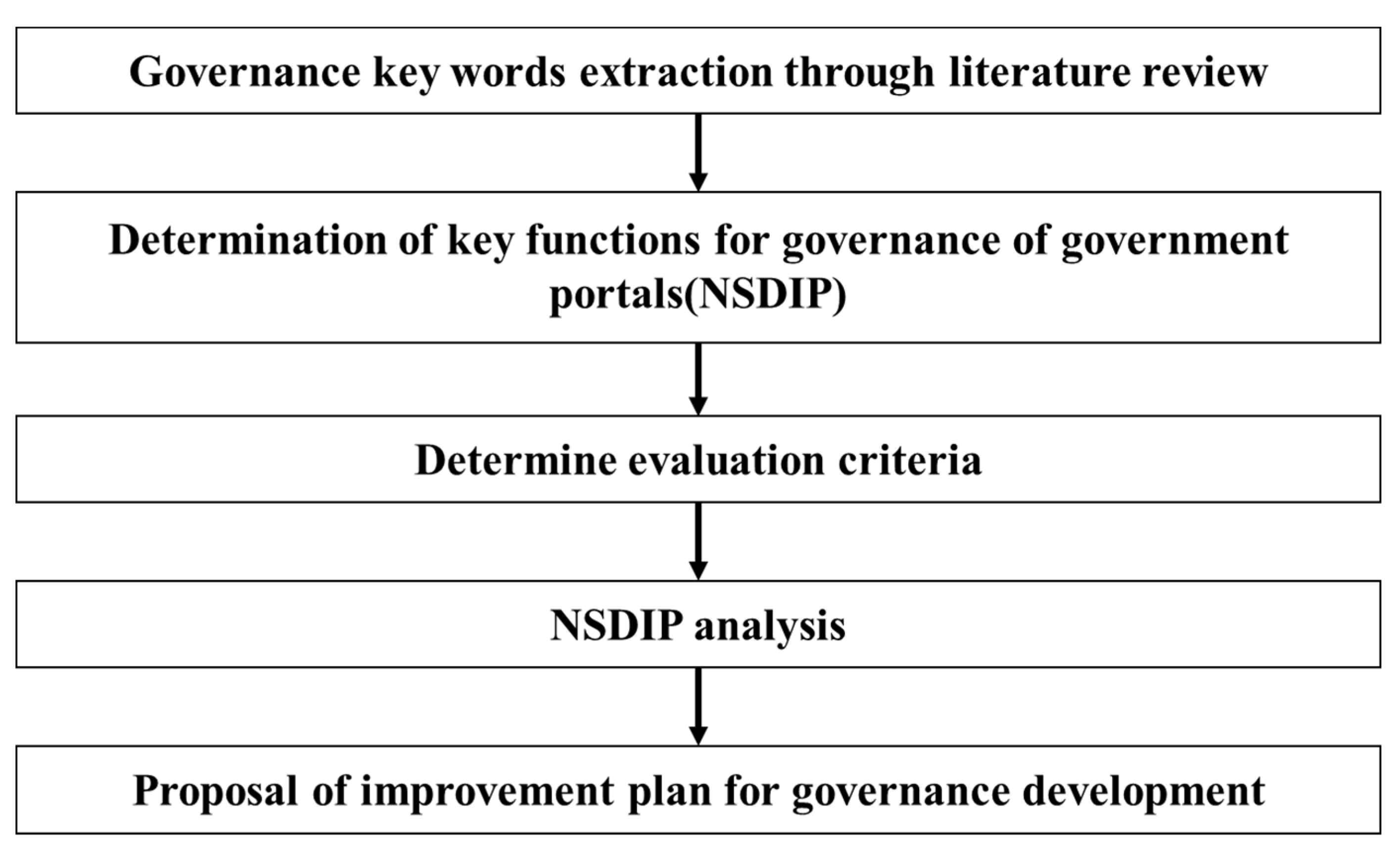
Figure 2.
Diagram of key words and evaluation criteria derivation.
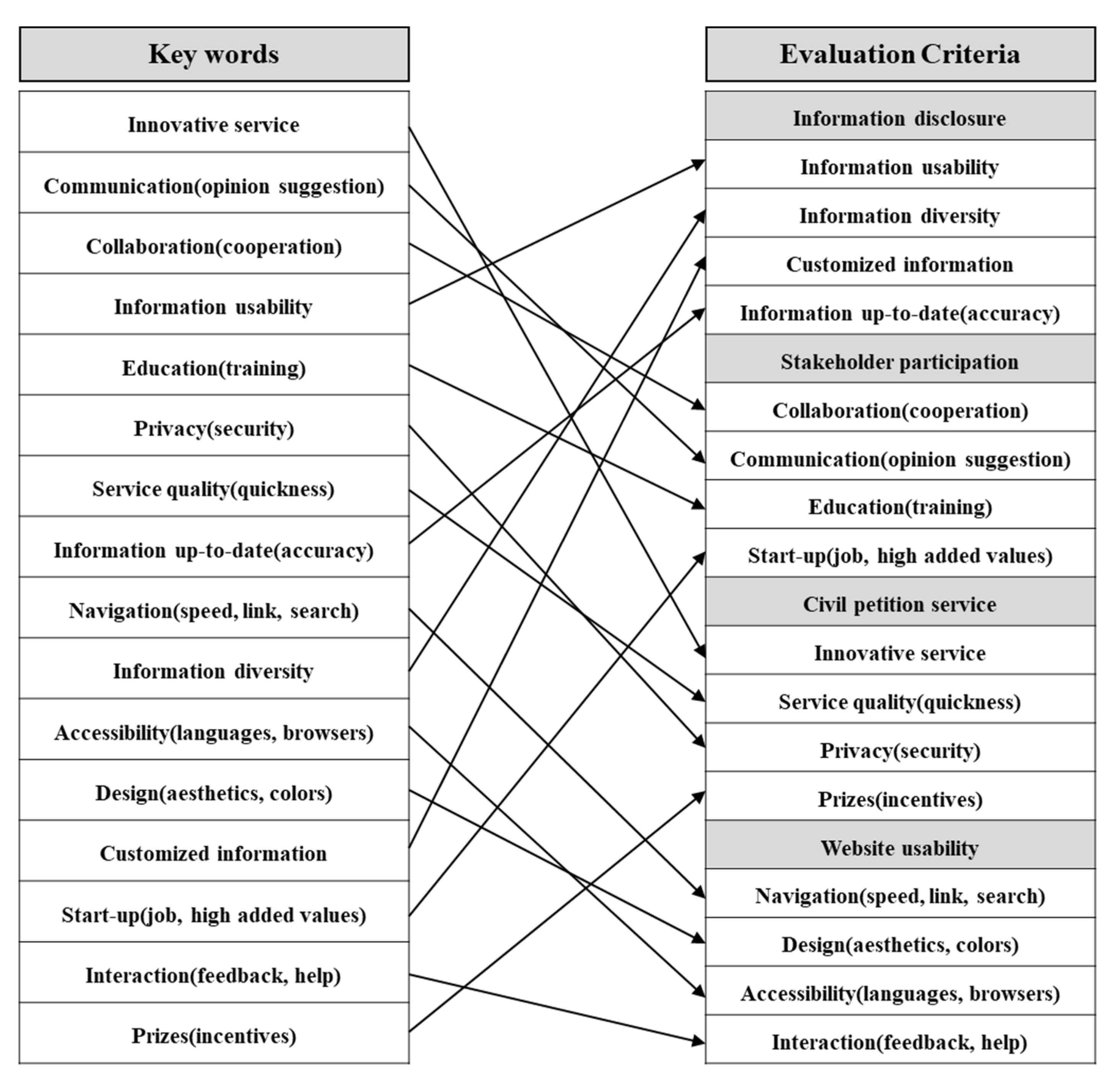
Figure 3.
Main webpage of NSDIP.
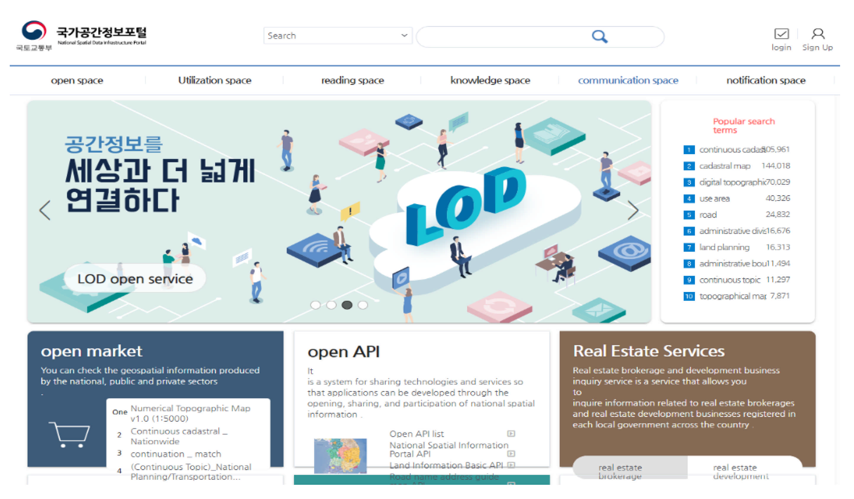
Figure 4.
Content diagram of NSDIP.
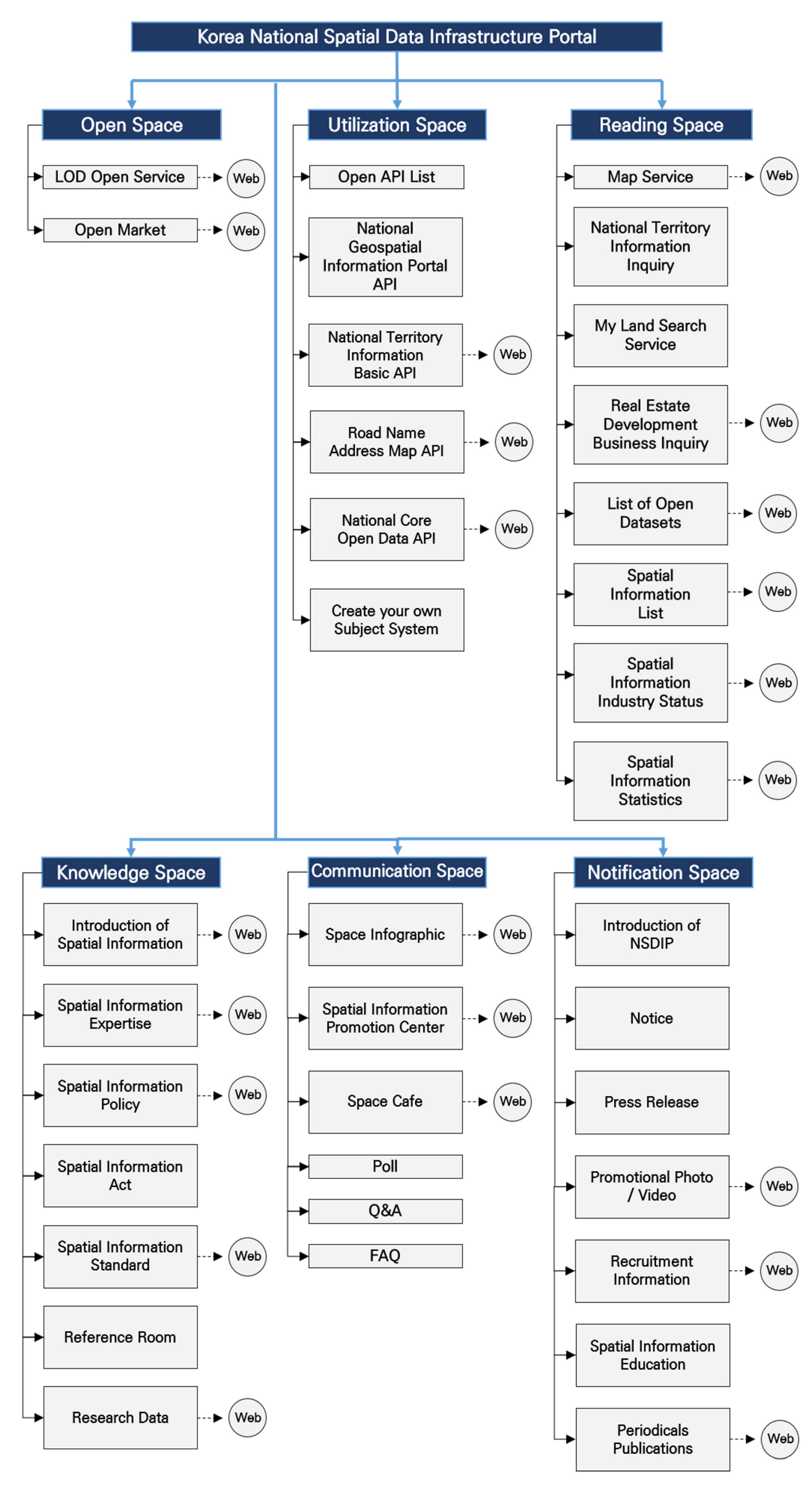
Figure 5.
Spatial dataset provided by ‘Open market’.
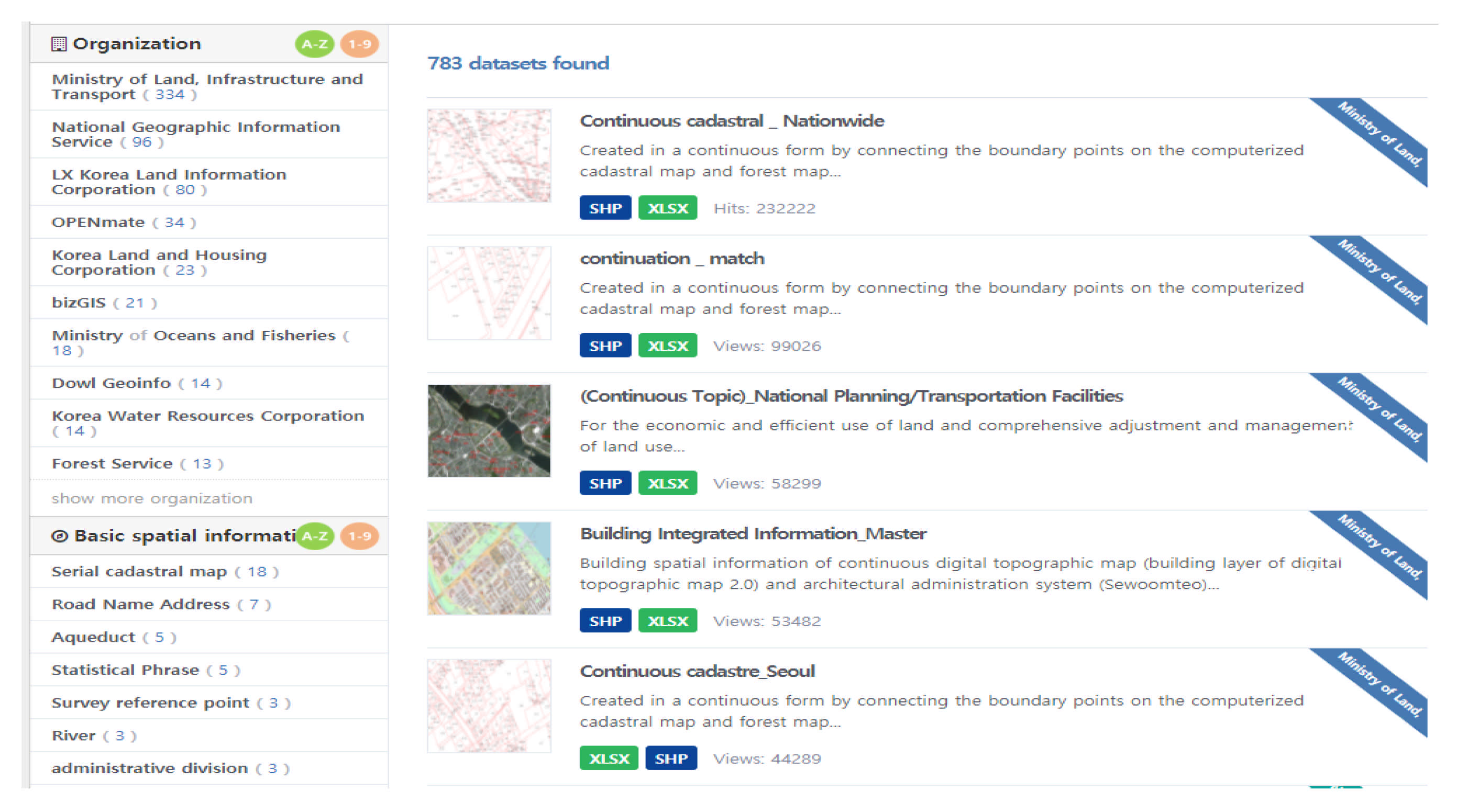
Figure 6.
Downloadable spatial data provided by ‘open market’.
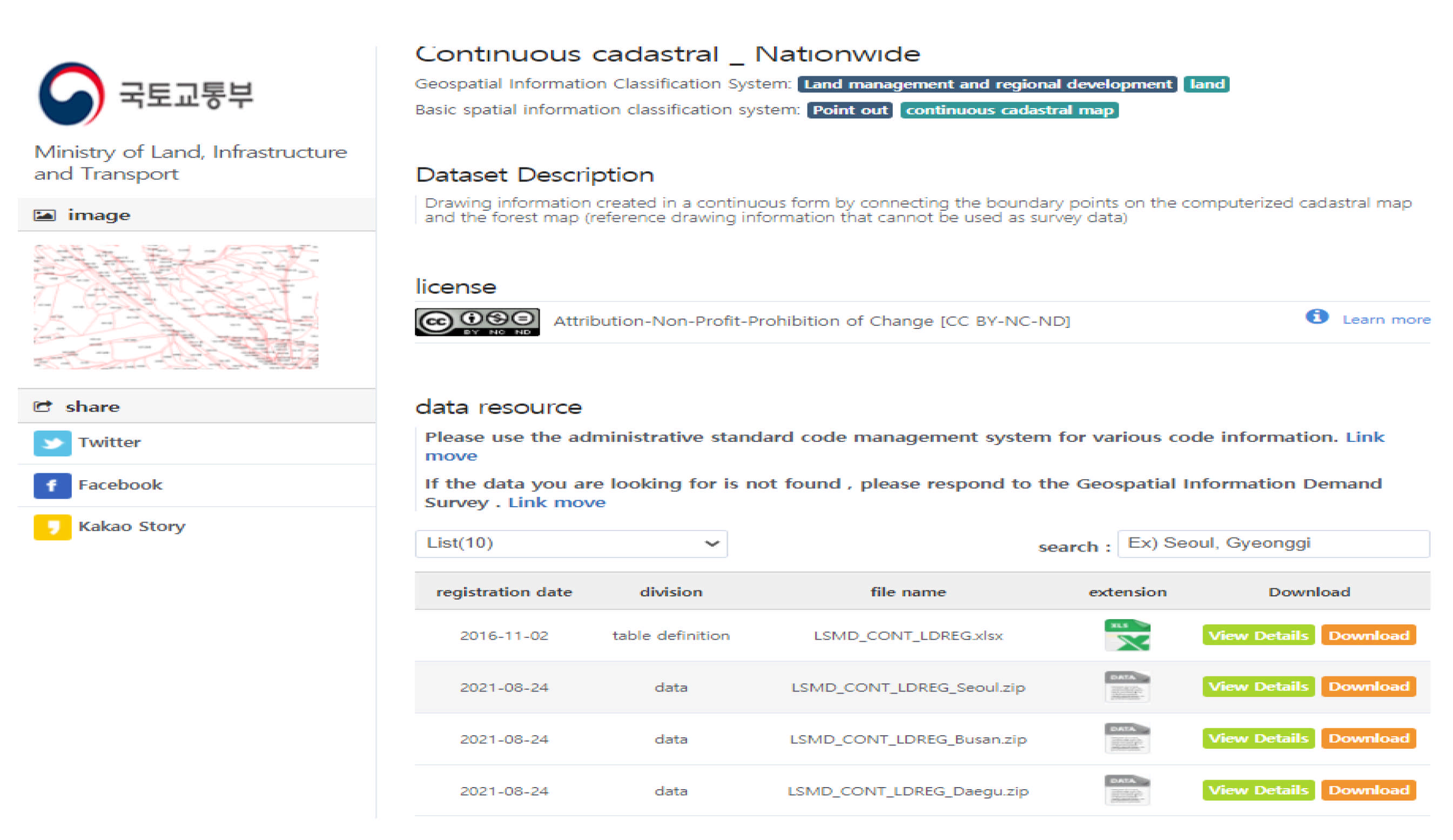
Figure 7.
Open API of ‘utilization space’.

Figure 8.
Map-based information provided in ‘reading space’.

Figure 9.
Participation and communication in ‘communication space’.
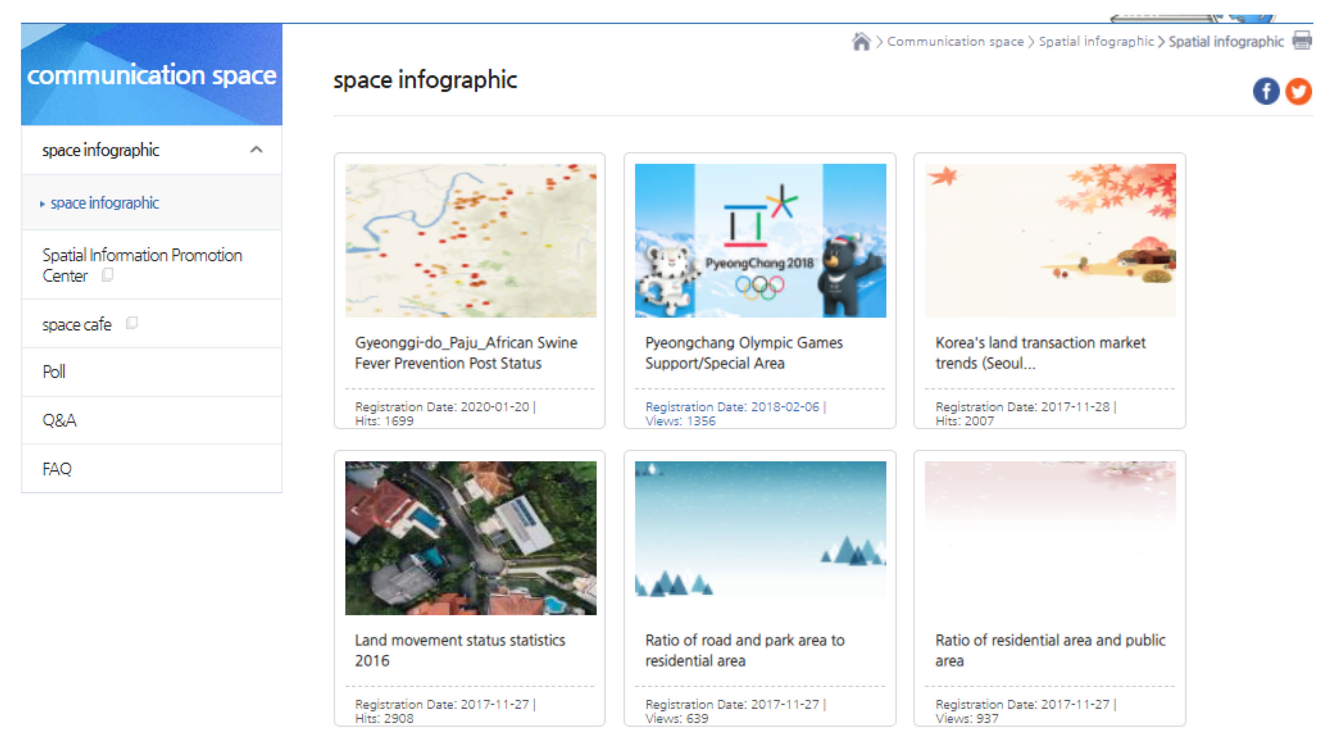
Figure 10.
User opinion recruitment on ‘poll’.
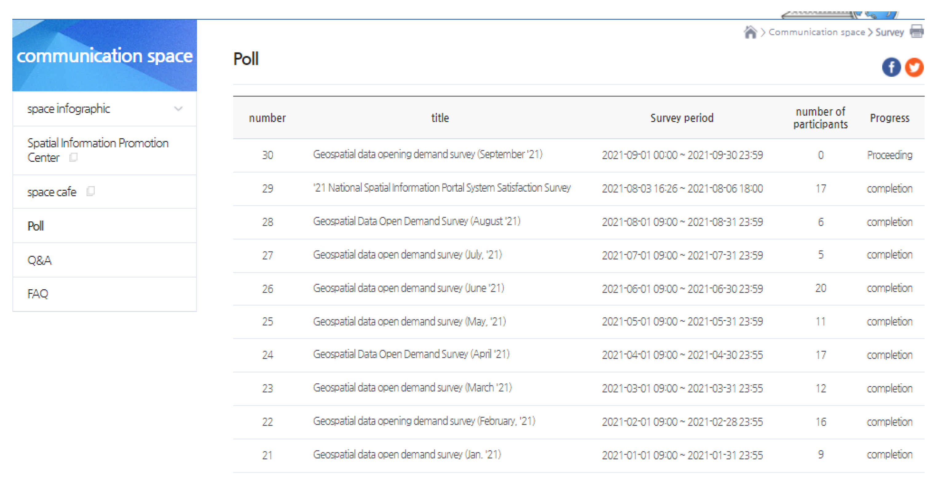
Figure 11.
Register your ideas in ‘create your own topic’.

Figure 12.
Providing spatial information by LOD in ‘open space’.

Figure 13.
Use cases by hyperlinks in ‘government department use cases’.
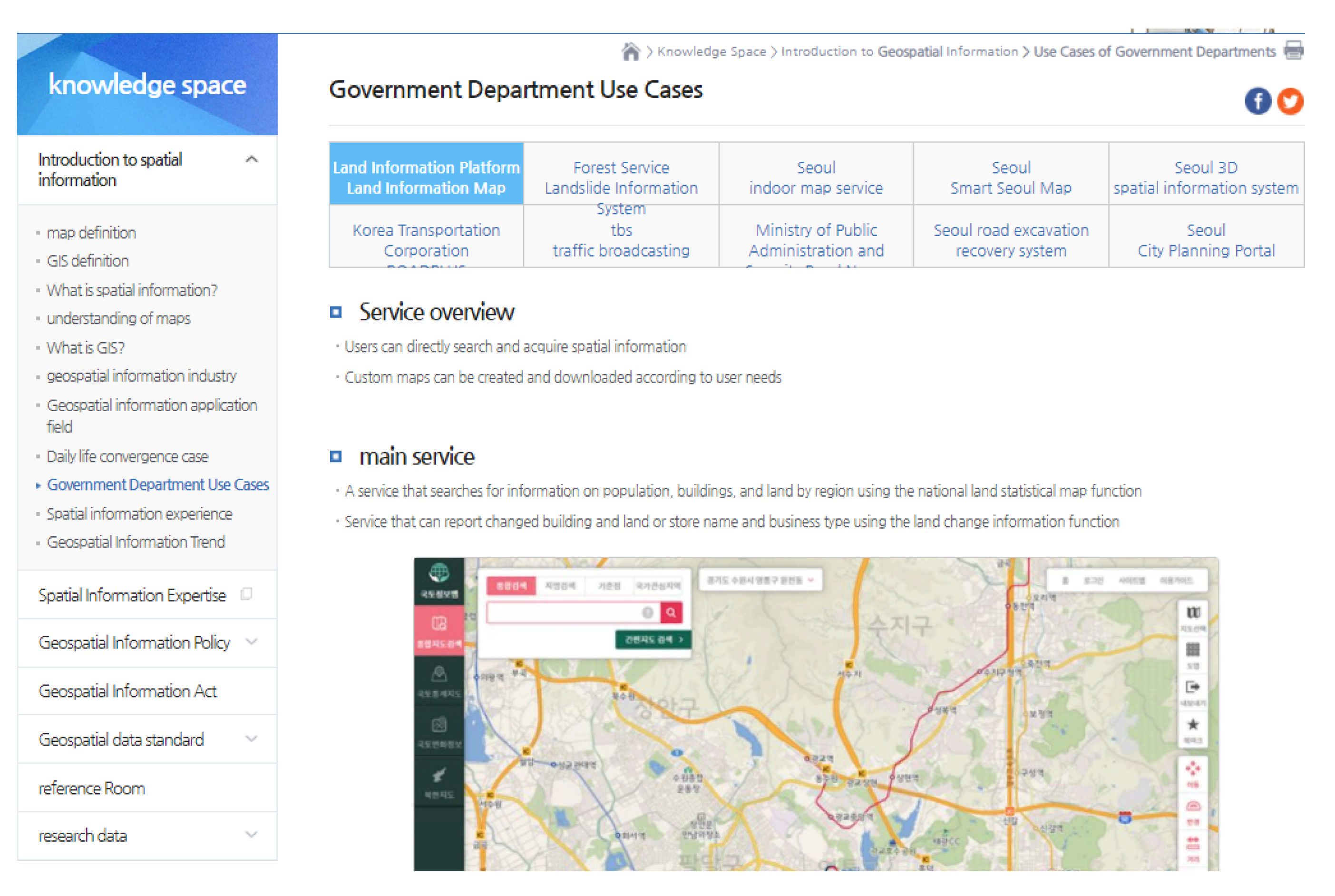
Figure 14.
Visualization of spatial information statistics in ‘reading space’.


Table 1.
Key words and references related to portal governance.
| Key Words | References |
|---|---|
| Innovative service | [2,4,5,7,8,9,14,15,16,17,22,33,34,36,40,47] |
| Communication (opinion suggestion) | [3,4,6,14,15,16,17,22,23,38,39,40] |
| Collaboration (cooperation) | [3,4,6,14,15,16,17,22,38,39] |
| Information usability | [5,6,17,22,26,33,34,35,37,38,40] |
| Education (training) | [5,22,35,36,38,39,43,44,45,46] |
| Privacy (security) | [2,22,23,33,35,37,42,44,47,48] |
| Service quality (quickness) | [2,5,14,17,18,22,33,34,35,36,40,43,47] |
| Information up-to-date (accuracy) | [2,6,17,22,23,31,32,33,34,35,36,43] |
| Navigation (speed, link, search) | [2,31,32,49,50,51,52,54,55,57] |
| Information diversity | [5,6,7,8,9,17,22,26,27,33,34,35,36,37,38,43] |
| Accessibility (languages, browsers) | [2,31,32,49,50,51,52,53,54,56,57] |
| Design (aesthetics, colors) | [2,31,32,49,50,51,52,55,56] |
| Customized information | [3,5,7,8,9,14,17,18,22,23,26,27,33,34,35,37,38] |
| Start-up (job, high added values) | [3,4,16,17,19,20,21,22,36,41,43] |
| Interaction (feedback, help) | [2,31,32,49,50,51,53,54,55,57] |
| Prizes (incentives) | [5,23,33,34,36,38,39,40,42,43,47] |
Table 2.
NSDIP evaluation of information disclosure.
| Criteria | Contents | Related Sessions |
|---|---|---|
| Information usability | · Improved usability so that spatial information owned by 205 agencies can be disclosed and utilized in various fields | · ‘open space’, ‘utilization space’, ‘reading space’, ‘knowledge space’ |
| · Creation of added value of spatial information by providing various APIs | · ‘Open API’ | |
| · Provides spatial information as well as real estate development/brokerage/industry trends, and recruitment information | · ‘reading space’, ‘notification space’ | |
| · Provides various data formats for user convenience | · ‘open market: format’ | |
| Information diversity | · A total of 67,278 datasets of spatial data were provided: land management and regional development (50.4%), road/transportation/logistics (17.0%), general administration (9.2%), map-related fields (8.6%), etc. | · ‘open space: open market’, ‘utilization space’, ‘reading space’, ‘knowledge space’ |
| · Provides vector and raster spatial information and attribute data | · ‘Open market’, ‘Reading space’, ‘Utilization space’ | |
| · Provision of spatial information expertise, policies, laws, standards, etc. | · ‘knowledge space’ | |
| Customized information | · Provision of spatial information for each government agency · Basic spatial information provided by catalog · Provided by spatial information classification system, tag, and format | · ‘open market’ |
| · Provides API for each type for business creation through spatial information processing | · ‘utilization space’ | |
| · Satisfaction survey on spatial information opening through demand survey | · ‘knowledge space’ | |
| Information up-to-date (accuracy) | · Data generated by 205 agencies are disclosed as hyperlinks, and in the case of digital topographic maps, the renewal cycle is once a year. | · ‘open market’ |
| · A total of 67,278 datasets of spatial data are disclosed, but the unification of the update cycle of each spatial data and quality management procedures according to OGC/ISO international standards are not disclosed. | · ‘open space’, ‘utilization space’, ‘reading space’, ‘communication space’, ‘knowledge space’ |
Table 3.
Evaluation of stakeholder participation in NSDIP.
| Criteria | Contents | Related Sessions |
|---|---|---|
| Collaboration (cooperation) | · User participation and cooperation are made through ‘spatial infographic’, ‘spatial information promotion center’, ‘spatial cafe’, ‘poll’, ‘Q&A’, and ‘FAQ’. | · ‘Communication space’ |
| · Cooperation to revitalize the industry by introducing participating companies, products, and providing examples of spatial information use · Collaboration with stakeholders through spatial data demand survey and satisfaction survey · Finding ways to cooperate to eliminate inconveniences | · ‘Communication space–spatial information promotion center’ · ‘Communication space: poll’ · ‘Communication space: Q&A’ | |
| · Establish a collaboration system by providing information on policy, real estate, land, cadastral, spatial information, and distribution | · ‘Communication space: FAQ’, ‘open space’, ‘utilization space’, ‘reading space’, ‘knowledge space’ | |
| Communication (opinion suggestion) | · Reinforce the communication system for the use of spatial data by conducting monthly data open demand survey | · ‘Communication space: poll’ |
| · Q&A related to overall spatial information including thematic maps, real estate, coordinate system, etc. | · ‘Communication space: Q&A’ | |
| · Reinforce communication by subject (policy, real estate, land, cadastral, spatial information, distribution) and data and provide FAQ | · ‘Communication space: FAQ’ | |
| · Create and register spatial information products with the user’s creative ideas | · ‘Utilization space’ | |
| · ‘Space café’ is divided into thematic map, category, and my space café and is open, but its utilization is low. | · ‘Communication space’ | |
| Education (training) | · Introduce the schedule of spatial information education (creative talent nurturing plan, introduction of academy education, academy curriculum) and recruit trainees | · ‘Notification space: spatial information education’, ‘spatial information academy’ |
| · A separate training course for prospective job seekers is established to provide employment after training. | · ‘Notification space: spatial information education’, ‘spatial information academy’ | |
| Start-up (job, high added values) | · 2021 Spatial information startup/creative user idea contest (award and prize support) | · ‘Notification space: notice’ |
| · Provide jobs in connection with National Recruitment Information Worknet (www.work.go.kr) | · ‘Notification space: recruitment information inquiry’ |
Table 4.
NSDIP evaluation of civil petition service.
| Criteria | Contents | Related Sessions |
|---|---|---|
| Innovative service | · Provide 67,278 datasets of spatial information owned by 205 governments and local governments using a web portal | · ‘Open space’, ‘utilization space’, ‘reading space’, ‘knowledge space’, ‘communication space’, ‘notification space’ |
| · Provide in LOD form so that it can be used for development of various services or applications related to spatial information by linking with addresses | · ‘Open space’ | |
| · Provided in the form of a CC (Creative Commons) license for free use of spatial information | ||
| Service quality (quickness) | · Service in new technologies and applications of spatial information through contests and expos | · ‘Notification space’ |
| · Advanced service quality through LOD (service/application development), API (providing data in KML or GEOJSON format and displaying map using visualization tool SDK) | · ‘Utilization space’, ‘open space’ | |
| · Provide a smart educational environment for industry-tailored education and nurturing of youth creative talent | · ‘Notification space’ | |
| · Provide prompt answers to Q&A, surveys, announcements, and spatial information education notifications | · ‘Communication space’, ‘notification space’ | |
| Privacy (security) | · For user privacy and security, one can log in through membership registration (foreign members can join) | · ‘Membership’, ‘login’ |
| · Some comments cannot be opened due to privacy protection in the communication of opinions by Q&A | · ‘Communication space’ | |
| · Requires membership registration when downloading spatial information | · ‘Open space: open market’ | |
| Prizes (incentives) | · Annual spatial information excellent users and startup ideas contest held (award, prize money) | · ‘Notification space’ |
| · Provide employment incentives after training through industry-tailored education reinforcement courses | · ‘Notification space: spatial information education’ |
Table 5.
Website usability evaluation of NSDIP.
| Criteria | Contents | Related Sessions |
|---|---|---|
| Navigation (speed, link, search) | · Smooth navigation of 6 main menus and sub-menus and hyperlinked organizations. | · ‘Open space’, ‘utilization space’, ‘reading space’, ‘knowledge space’, ‘communication space’, ‘notification space’ |
| · Search by type, format, and institution (by word/topic) of spatial information is performed smoothly. | · ‘Open space’, ‘utilization space’, ‘reading space’, ‘knowledge space’, ‘communication space’ | |
| Design (aesthetics, colors) | · Colors and menus are configured so that the site map function of the website makes it convenient for users to search for spatial information. However, since a lot of information is provided, users may feel pressured, so a design for providing customized information is required. | · ‘Open space’, ‘utilization space’, ‘reading space’, ‘knowledge space’, ‘communication space’, ‘notification space’ |
| · Designed to select text, graphic mode considering the user environment of the home page. | · ‘Open space’, ‘utilization space’, ‘reading space’, ‘knowledge space’, ‘communication space’, ‘notification space’ | |
| Accessibility (languages, browsers) | · It is built in the Korean version, and the English version provides very little information. | · ‘Open space’, ‘utilization space’, ‘reading space’, ‘knowledge space’, ‘communication space’, ‘notification space’ |
| · It should be designed so that minority groups such as children and the disabled can easily access spatial information. | · ‘Open space’, ‘utilization space’, ‘reading space’, ‘knowledge space’, ‘communication space’, ‘notification space’ | |
| Interaction (feedback, help) | · Feedback and help are provided through Q&A, surveys, announcements, press releases, space cafes, and creating one’s own topic maps. | · ‘Notification space’, ‘communication space’, ‘utilization space’ |
Table 6.
Improvement plan for information disclosure.
| Improvement Plan | Evaluation Criteria |
|---|---|
| · A portal design that can provide customized spatial information by setting a catalog considering the level of the user group and the characteristics of the field of application of spatial information is required. | · Information usability, information diversity, customized information |
| · In order to create added value of spatial data, various APIs are provided, and ideas or new products developed by users are disclosed to maximize the expected effect of open spatial data. | · Information usability, customized information |
| · Collect users’ opinions through Q&A, surveys, and spatial cafes, disclose improvement plans, and continuously disclose new spatial information. | · Information diversity, customized information |
| · Establish a sustainable accuracy management plan to systematically secure the up-to-date spatial information in accordance with OGC/ISO international standards. | · Information up-to-date (accuracy) |
| · Improving user-friendly information retrieval and visualization by making it easy to search and analyze data based on geographic location using a web GIS viewer. | · Information usability, information diversity, customized information, information up-to-date (accuracy) |
Table 7.
Improvement plan of stakeholder participation.
| Improvement Plan | Evaluation Criteria |
|---|---|
| · Continuously implement publicity and events that can promote user participation through ‘communication space’ and ‘notification space’, and feedback through users’ ideas and opinions. | · Communication (opinion suggestion), collaboration (cooperation) |
| · Proposes exhibitions or contests where users can propose creative ideas and solutions using spatial information at all times on the portal and provide a space for mutual communication. | · Communication (opinion suggestion), collaboration (cooperation) |
| · Increasing participation by securing innovative portal openness that allows users to freely access and use the portal, breaking away from the current method that requires users to sign up and log in to the portal. | · Communication (opinion suggestion), collaboration (cooperation) |
| · Excellent ideas and solutions can be developed as prototype products through simulation, providing institutional support measures, and improving added value through start-ups and job creation. | · Collaboration (cooperation), start-up (job, high added values) |
| · Expand the base of professional knowledge by inviting experts to educate the government, local governments, businesses, and citizens on the latest spatial information solutions. | · Education (training) |
Table 8.
Improvement plan of civil petition service.
| Improvement Plan | Evaluation Criteria |
|---|---|
| · Establish open and innovative service systems that can communicate with each other by establishing an interactive service system through a portal | · Innovative service, service quality (quickness) |
| · It is necessary to promote service quality advancement through LOD and API, introduce web GIS function to improve spatial information visualization quality, and to provide various services by supplementing spatial statistical analysis function. | · Innovative service, service quality (quickness) |
| · It is required to discover creative ideas and excellent solutions through contests and expos, provide various incentives, and discover start-up support services that can support start-ups. | · Innovative service, service quality (quickness), prizes (incentives) |
| · Spatial data services are subject to surveillance and privacy violations due to location exposure, so legal and institutional devices are needed to protect privacy and secure security. | · Privacy (security) |
| · In addition to the free opening of spatial information, it is necessary to prepare a legal and institutional mechanism to deal with intellectual property rights issues related to processing and production. | · Privacy (security) |
Table 9.
Improvement plan for website usability.
| Improvement Plan | Evaluation Criteria |
|---|---|
| · A portal design is required to provide an innovative portal function capable of near real-time data, volunteered geographical information, and online geo-processing. | · Navigation (speed, link, search), design (aesthetics, colors) |
| · It is necessary to design an information architecture that is optimized through surveys and feedback, and it is also necessary to supplement the functions of three-dimensional visualization, user feedback, dynamic visualization, and search functionality. | · Navigation (speed, link, search), design (aesthetics, colors), interaction (feedback, help), accessibility (languages, browsers) |
| · Introducing web GIS and open source R statistical software to improve accessibility in information retrieval and analysis, and an English version and web design for the underprivileged (children, disabled, etc.) are required. | · Accessibility (languages, browsers), interaction (feedback, help) |
| · Reinforce international standardization of portals by reflecting international standards in web design. | · Navigation (speed, link, search), design (aesthetics, colors), interaction (feedback, help), accessibility (languages, browsers) |
Publisher’s Note: MDPI stays neutral with regard to jurisdictional claims in published maps and institutional affiliations. |
© 2021 by the authors. Licensee MDPI, Basel, Switzerland. This article is an open access article distributed under the terms and conditions of the Creative Commons Attribution (CC BY) license (https://creativecommons.org/licenses/by/4.0/).
Share and Cite
MDPI and ACS Style
Yoo, Y.; Kim, S.-s. Strategic Analysis for Governance Development of National Spatial Data Infrastructure Portal in Korea. ISPRS Int. J. Geo-Inf. 2021, 10, 654. https://doi.org/10.3390/ijgi10100654
AMA Style
Yoo Y, Kim S-s. Strategic Analysis for Governance Development of National Spatial Data Infrastructure Portal in Korea. ISPRS International Journal of Geo-Information. 2021; 10(10):654. https://doi.org/10.3390/ijgi10100654
Chicago/Turabian StyleYoo, Yejin, and Seong-sig Kim. 2021. "Strategic Analysis for Governance Development of National Spatial Data Infrastructure Portal in Korea" ISPRS International Journal of Geo-Information 10, no. 10: 654. https://doi.org/10.3390/ijgi10100654
Note that from the first issue of 2016, this journal uses article numbers instead of page numbers. See further details here.