Article

Wintering Habitat Use Pattern of Red-Crowned Cranes in the Korean Demilitarized Zone

Department of Environmental Science and Engineering, Ewha Womans University, Seoul 03760, Korea
J. Open Innov. Technol. Mark. Complex. 2018, 4(4), 58; https://doi.org/10.3390/joitmc4040058
Submission received: 15 May 2018 / Revised: 21 November 2018 / Accepted: 22 November 2018 / Published: 5 December 2018

Abstract

:
The study was the first attempt to identify the habitat use pattern of red-crowned cranes (Grus japonensis) around the demilitarized zone (DMZ) by overlapping coordinates with the land cover classification (LCC). Daily habitat use pattern was highly different (P = 0.000) between daytime (06:00–18:00) and nighttime (18:00–06:00). Cranes in Cheolwon used agricultural paddies more frequently in the daytime (P = 0.002), and forest areas at night and this indicated that cranes presumably use rice paddies for feeding and forests for resting, respectively. Cranes night time in Paju used wetlands more often than random expectation based on the available wetland surface area (P = 0.017). This indicated a different habitat use pattern between coastal (Paju) and inland (Cheolwon) areas. Securing agricultural paddies is important for providing crucial areas for feeding, and forests should be important for rest during the night time in Cheolwon, which support crane populations during their wintering migration in Korea.

1. Introduction

Cranes of the genus Grus are listed as some of the most endangered bird species in the world. Many are recognized as ‘Critically endangered’ under the IUCN Red List category [1]. Among the 15 crane species in the world, four occur in Korea: red-crowned crane (Grus japonensis), white-naped crane (G. vipio), hooded crane (G. monacha), and common crane (G. grus). Of them, red-crowned cranes and white-naped cranes are regular visitors to the Korean peninsula, especially in the Demilitarized zone (DMZ). Most species migrate long distances and stop over several rest-sites during their migration [2].
In the south of the DMZ there is CCZ (Civilian Control Zone) only in the South Korean side, and cranes spend 60–80% of their time in the fields searching for food and feeding [3], indicating the importance of foraging in winter. Their primary food in winter is rice grains that fall during the harvest. The birds are mostly observed on unplowed rice paddies rather than on plowed land [4]. Pae and Won [5] suggested that cranes visit the rice fields for feeding and they observed a frequent movement between rice fields and nearby forests and wetland areas. Thus, it is expected that the birds would be more often seen foraging on the rice fields than in other areas. However, crane species also use other habitats, except rice paddies, for their resting. In the DMZ there are forested areas yet entrance to them is prohibited due to the military purpose of the zone. There are streams and wetlands there that the crane species depend on for feeding and resting. Most crane studies were focused on the use of rice paddies, but at the large landscape level the habitat use pattern has never been tested. In this study, we compared the habitat use pattern of red-crowned cranes around the DMZ to test the hypothesis that crane habitat use is different between the time of day as a result of their daily behavior patterns; thus, we would like to test it in the DMZ.
Agriculture is recognized as a major driver of global biodiversity loss: agricultural intensification caused by the green revolution has been paralleled throughout the world [6], and agricultural land use is predicted to continue expanding in the next 50 years, particularly in Asian and African countries. There is clearly an urgent need to understand what is happening to the relationship between agriculture and biodiversity in regions other than Europe and North America. More importantly, earlier reviews of biodiversity conservation in rice paddy areas have mostly focused on the value of rice fields as providers of wetland habitats, which support the biodiversity.
The study of these birds’ migration routes and habitats has recently advanced due to the use of transmitters that can be tracked by satellite [7,8,9]. Previous studies showed that cranes require wetlands and wetland areas in many places around the world are being pressured by the rapid conversion of residential and commercial complexes. As a result, animals in these areas are strongly affected. Based on crane migration studies, securing wetland reserves is an important method and it is especially true in areas surrounded by agricultural paddies. Cranes often stay in rice paddies for food and are often observed frequently moving between wetlands and nearby forests. However, habitat use pattern was not strongly shown in quantitative ways, especially in the Korean DMZ because entry is strictly prohibited.
Recently, remote tracking methods have become especially useful for endangered and rare species that require systematic analysis of habitat use during migration. However, most studies using satellite-tracking only focused on migration routes, but the exact habitat use pattern on the ground remained unknown. Therefore, the purpose of this study was to identify the key habitats utilized in the DMZ by identifying habitat use during wintering migration and securing a key habitat for crane species. The results will help to enhance crane conservation in the DMZ.

2. Study Areas and Methods

2.1. Study Areas

The study area is located in the DMZ and the surrounding areas of the Civilian Control Zone (CCZ). The DMZ is a 248 km long, 2 km wide border separating North and South Korea from East to West. The DMZ comprises 19,294 km2, approximately 2% of the total Korean peninsula. The CCZ is located outside of the DMZ and exists only in South Korea (including coastal areas in east and west), ranging from 5–20 km in width [10]. This area is relatively flat with wetlands bordering the Han River in the eastern areas of Paju as a result of overflow during the summer monsoon season.
Outside the DMZ there is the Civilian Control Zone (CCZ) between North and South Korea, which contains some of the most important wintering sites for wintering crane species [11]. The DMZ is a 4 km wide zone running across the Korean peninsula, with an area of 907 km2. There are no farms or human residences within the DMZ. South of the DMZ, in South Korea, is the CCZ, a 5–20 km wide zone under military control, with some rice cultivation and a limited human population. Despite their critical importance to the conservation of these two species of cranes, detailed analyses of crane ecology and behavior at these sites have rarely been conducted due to military restrictions on access.
Furthermore, a Civilian Control Line (CCL) was set up that varies from 5 km to 20 km from the DMZ southern boundary. This line creates the boundary of the CCZ. The borderline area passing the CCL partially includes two provinces and 14 cities or counties. In spite of these residential areas, the CCZ is made up of primarily farm and forest lands.
The CCZ is composed of villages and agricultural areas, and forests in the DMZ are well developed and remain relatively undisturbed by humans. This situation results in a vast expanse of agricultural paddies, and recently, thanks to the introduction of machinery, increased amounts of left-over rice after the harvest, providing fodder for cranes during their winter migration [5]. Other species common to these areas include: bean geese (Anser fabalis), white-fronted geese (A. albifrons), mallards (Anas platyrhynchos), and teal (A. crecca).

2.2. Habitat Estimation

A total of six red-crowned cranes (five cranes in 1993, one in 1994) were used in this study. Each individual was equipped with a satellite transmitter, known as platform transmitter terminals (PTTs), and then released on site. The transmitters measured 80 × 60 × 35 mm with a 180 mm antenna and had a weight of 80 g. The transmitter was attached to a harness made with Teflon ribbons that were used to attach the unit to the cranes breastbone, but not surgically implanted. The total weight of the PTT and harness was 130 g, which is about 2% of the body weight of an adult crane [12]. Signals from the transmitter were sent to the ARGOS system on board the NOAA weather satellites. The system uses Doppler shift as the satellite passes overhead to calculate the position for each bird. The ground receiving station sends the data to the World Computing Services Center, which then converts the data to usable coordinates such as latitude and longitude, which are then transmitted to the researchers through the internet.
The PTT transmitters were set to a 6 hours active and 12 hours inactive cycle with 60 seconds between pulses while active during the period of this study. Coordinates were transmitted 1–7 times per day between the middle of November and the end of December in 1993 and in 1994. The data was used to analyze Transverse Mercator (TM) and the coordinate system of Geodetic Datum, Tokyo.

2.2.1. Determination of Available Habitats

The land cover classification (LCC) is the basic information required for remote-sensing and a use of the land surface pattern from the surface. It is composed of nine categories: deciduous forests, mixed forests, coniferous forests, stream channels, rice fields and agricultural areas, wetlands, open areas, grasslands, road, and housing areas, which enables us to understand the land conditions from the satellite (Appendix A). The study found the movement pattern of cranes in DMZ with land cover classification (LCC), which had been established by the Ministry of Environment in Korea in 1998.

2.2.2. Determination of Used Habitats

Intuitively, the kernel method consists of placing a kernel (probability density) over each observation point in the sample. A regular rectangular grid is superimposed on the data, and an estimate of the density is obtained at each grid intersection, using information from the entire sample. The estimated density at each intersection is essentially the average of the densities of all the kernels that overlap that point. Observations that are close to a point of evaluation will contribute more to the estimate than will ones that are further from it. Thus, the density estimate will be high in areas with many observations, and low in areas with few.

2.3. Statistical Analysis
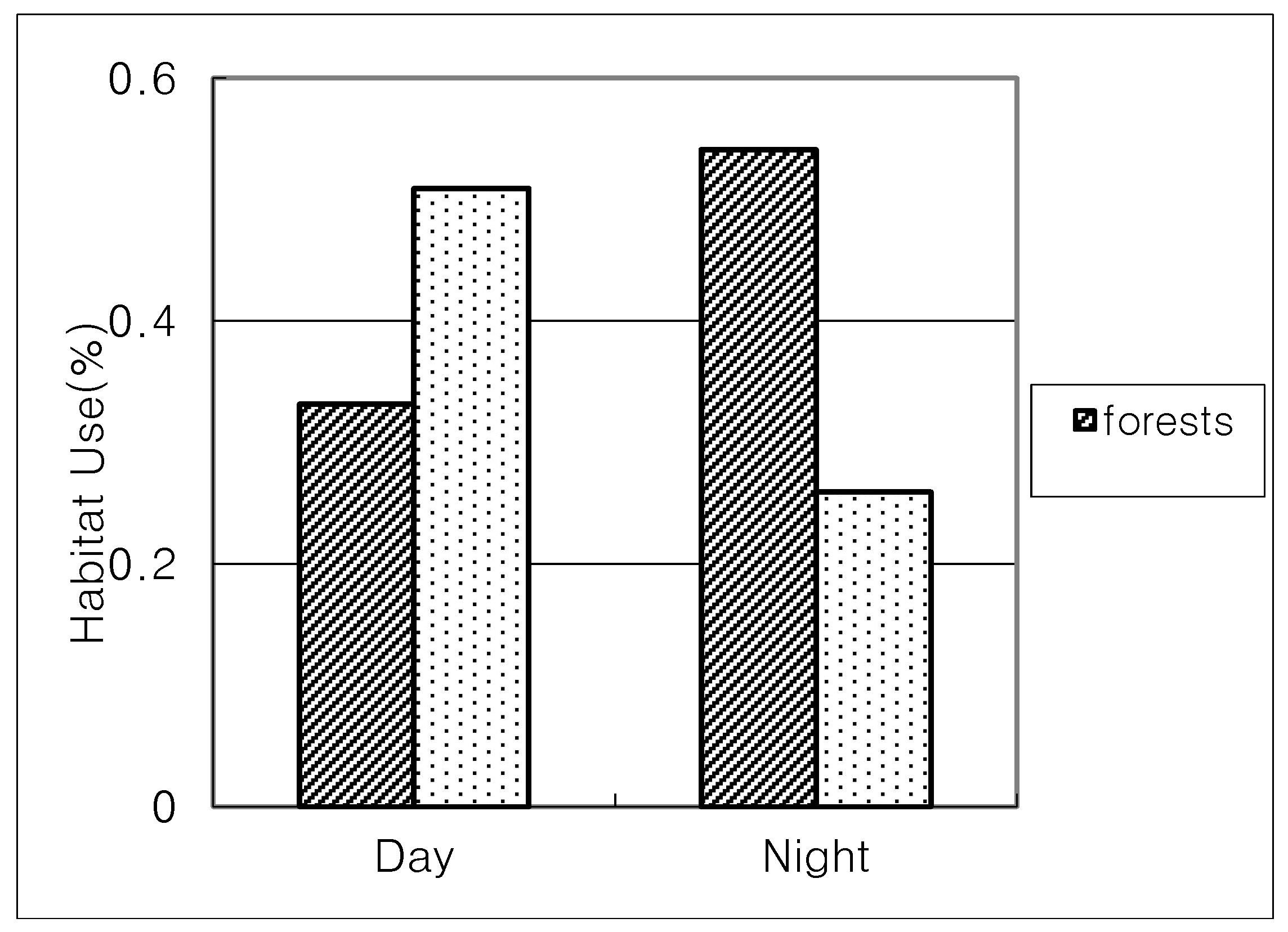
A habitat use pattern was analyzed based on a land cover map. The daily movement pattern can be divided into two time periods: daytime (06:00–18:00) and nighttime (18:00–06:00). The habitat use pattern was compared between day and night. A land use percentage by cranes was calculated for each coordinate point from the transmitter using data points.
We estimated the total area of each habitat based on the calculation for each coordinate both in the Cheolwon and Paju areas separately. The habitat use pattern was compared between daytime and nighttime using a Wilcoxon signed-rank test in the Cheolwon area only. The total area of each habitat type was estimated to compare the percentage of crane habitat use in Paju and Cheolwon separately. The chi-square test was used to test whether use of various habitat types by birds is non-random. For this test, data from seven individuals were pooled together. Although such pooling may result in, strictly speaking, non-independent data because they were measured many times on the same individuals, the location readings were made at intervals of 2–3 days, which might have contributed to the relative independence between the consecutive locations of an individual. Identification of the preferred habitat types used by cranes was tested [13] (and to see the changes in habitat use between day and night.

3. Results

Cranes used the DMZ in the Paju (n = 115) and Cheolwon areas (n = 254) during 1993–1994 (Table 1). A total of six individuals were used to acquire data. Coordinates for each area were overlapped in the LCC map.
In the Cheolwon area, it was possible to obtain the activity pattern during the day (n = 169) and night (n = 85) (Table 2), but for the Paju area, only nighttime data were used in the analysis (n = 115) (Table 3). In the Paju areas the agricultural areas were used more often than other habitat types (45.22%), but wetlands (mudflats) were also often used (19.97%).
The percentage of use of agricultural areas by cranes in Chelwon was higher during the day than at night (Wilcoxon test; Z-value = 7.623, n = 6; P = 0.000) (Figure 1).
In Cheolwon, estimating the size of the total area of each habitat by the kernel method and the habitat use pattern in daytime was compared and it was significantly different (chi-square value = 22.47, df = 7, P = 0.002). Use of various habitats at night (data pooled from all five individuals: chi-square value = 59.053, df = 7, P = 0.000; Table 2) and during the day (chi-square value = 22.47, df = 7, P = 0.002) was different from the randomly expected use based on the proportions of surface area covered by each habitat type in the Chelwon area. Use of various habitats at night by one crane in the Paju area was also significantly different from the randomly expected use (chi-square value = 18.62, df = 8, P = 0.017) (Table 3).
The kernel estimation and nighttime habitat use pattern was also significantly different (chi-square value = 59.053, df = 7, P = 0.000).
In the Paju area, the habitat use pattern was compared with the total area of each habitat in this area. The chi-square results showed a significant difference in habitat use pattern (chi-square value = 18.62, df = 8, P = 0.017) (Table 3).

4. Discussion

This study attempted to identify the movement patterns of red-crowned cranes around the DMZ using data from satellite tracking. Crane migration routes in Korea can be either to the east coastal areas of the Paju area or to the Cheolwon area. These results are consistent with previous studies of migration routes in the Korean peninsula [14].
This was the first study to attempt to identify the ground use pattern of cranes using satellite tracking data. Previous studies showed the migration routes in Korea, but did not show information regarding the habitat types used by the cranes.
How can a comparison crane activity from 1993–94 with habitat data from 2018 be justified? There might have been a change in the LCC from then and now; however, the difference should be small for this time period. Considering the unique nature of the DMZ, entry into this area is not permitted without special government authorization, thus posing a barrier for studies.
The cranes were found to use agricultural paddies for foraging; this could be the reason why cranes used the DMZ for their wintering grounds as this area had high amounts of grain leftover from the harvest [3]. Having little human disturbance may be another reason that the area is a popular stopover for wintering cranes.
Crane habitat was significantly different from day and night (Figure 1). During the day, cranes used agricultural paddies but at night they moved to the forests, presumably for resting and to avoid predation. The DMZ is also a popular site for black vultures (Aegypius monachus), Peregrine falcons (Falco peregrinus), and kestrels (F. tinnunculus) due to the high abundance of waterfowl [14]. This observation is similar to that of [15] who observed cranes movement to the CCZ during the day and to the DMZ at night. However, they only observed the movement pattern but did not show the percentages of habitat use. It was also found that the farmland area needed to support existing crane populations in wintertime, free from the disturbance caused by human activities and vehicular spatial patterns [14].
This study also had a limitation of crane activity because the crane location data did not distinguish if the birds were on the ground or in flight. The actual activities of cranes need further clarification in future studies. However, this study has shown the importance of different habitats on crane behaviors. The importance of rice fields as winter foraging grounds should be secured for feeding two threatened crane species. However, the predation threat to cranes is also present because there are large numbers of black vultures and hawks, in addition to lynx and raccoons. The increased threat of predators forces them use the rice fields during daytime and the forests at night time. Forests are potentially more secure from predation pressure.
Also, most rice paddies are located in the CCZ and there are roads for military use and tourists. Agricultural activities also are common in the CCZ whereas most forests are located in the DMZ [16] and civilian control is very tight and as a result cranes face little pressure, thus they prefer this area for nighttime resting and sleep.
The pressure for land development both in the CCZ and elsewhere in Korea is increasing so that it is now necessary for wildlife managers to consider the foods available to migratory cranes during the wintertime [17]. This can be achieved by payments or other incentives from governmental agencies or conservation organizations to farmers who leave fields unplowed. Such programs have been widely implemented in Europe and are being considered in other countries. Also, because farmers in this region receive a higher price for their rice as it is marketed as ‘Cheolwon Crane Rice’, perhaps local farmers’ associations could be approached to voluntarily leave some fields unplowed in order to maintain these two culturally important species. Cranes in these areas are usually exposed to predation pressure and they tend to form a large flock as a result [18].
Cao et al. [19] also reported that red-crowned cranes have expanded their breeding sites from the original marshland to farmland by adaptively increasing home range sizes and including a wider range of food resources in their diets. My study also indicated the need to limit the development or modification of agricultural paddies into villages or other uses for the conservation of cranes. Currently, there is great pressure for modification into residential areas to ease population density on the Korean peninsula.
The DMZ and CCZ’s status as bio-reserves is in jeopardy because of increasing pressure for agricultural, industrial, and urban development from both the south and north [11]. This study only analyzed data from 1993 and 1994, and may only be a small window in to the movement of cranes in the DMZ because of the limited number of transmitters and due to changes in climate. A long-term study should be conducted to determine a clear relationship between crane activities and habitat use pattern.

Funding

This study was funded by Ministry of Education (NRF-2017R1D1A1B03029300).

Acknowledgments

Authors wish to thank Hiroyoshi Higuchi for providing data and J.H. Jung for data analysis on the manuscript.

Conflicts of Interest

The author declares no conflict of interest.

Ethics

This study is free from ethics approval.

Appendix A

Table A1. The category of habitat pattern based on the Land Cover Classification.
Habitat CategoryExplanation
deciduous forestsnatural (or artificial) deciduous forests > 75% of total areas
Mixed forests mixed forests of deciduous and coniferous
Coniferous forests natural (or artificial) coniferous forests > 75% of total areas
Streamsinland streams
Rice fields, agricultural areas rice fields, agricultural areas
wetlandsareas with permanent water, tidal flats
Open areasdenuded areas with mines, roads
Grasslandsgrasslands
roads, housing areasresidential areas or industrial areas

References

  1. Archibald, G.W.; Meine, C.D. Order Gruiformes, family Gruidae (Cranes). In Handbook of Birds of the World; del Hoyo, J., Elliott, A., Saragatal, J., Eds.; Hoatzin to Auks; Lyns Edicion: Barcelona, Spain, 1996; Volume 3, pp. 60–89. [Google Scholar]
  2. BirdLife International. Threatened Birds of Asia: The BirdLife International Red Data Book; BirdLife International: Cambridge, UK, 2001. [Google Scholar]
  3. Lee, S.D.; Jablonski, P.; Higuchi, H. Winter foraging of threatened cranes in the Demilitarized Zone of Korea: Behavioral evidence for the conservation importance of unplowed rice fields. Biol. Conserv. 2007, 138, 286–289. [Google Scholar] [CrossRef]
  4. Lee, S.D.; Jablonski, P.; Higuchi, H. Effect of heterospecifics on foraging of endangered Red-crowned and White-naped cranes in the Korean Demilitarized Zone (DMZ). Ecol. Res. 2007, 22, 635–640. [Google Scholar] [CrossRef]
  5. Pae, S.H.; Won, P.O. Wintering ecology of Red-crowned cranes and White-naped cranes Grus japonensis and G. vipio in the Cheolwon Basin, Korea. In The Future of Cranes and Wetlands; Higuchi, H., Minton, J., Eds.; Wild Bird Society of Japan: Tokyo, Japan, 1994; pp. 97–196. [Google Scholar]
  6. Fujioka, M.; Lee, S.D.; Kurechi, M.; Yoshida, H. Bird use of rice fields in Korea and Japan. Waterbirds 2010, 33, 8–29. [Google Scholar] [CrossRef]
  7. Jouventin, P.; Weimerskirch, H. Satellite tracking of wandering albatrosses. Nature 1990, 343, 746–748. [Google Scholar] [CrossRef]
  8. Higuchi, H.; Ozaki, K.; Fujita, G.; Minton, J.; Ueta, M.; Soma, M.; Mita, N. Satellite tracking of white-naped crane migration and the importance of the Korean Demilitarized Zone. Conserv. Biol. 1996, 10, 806–812. [Google Scholar] [CrossRef]
  9. Higuchi, H.; Shibaev, Y.; Minton, J.; Ozaki, K.; Surmach, S.; Fujita, G.; Momose, K.; Momose, Y.; Ueta, M.; Andronov, V.; et al. Satellite tracking of the migration of the red-crowned crane, Grus japonensis. Ecol. Res. 1998, 13, 273–282. [Google Scholar] [CrossRef]
  10. Lee, S.D.; Chung, E. The current status of ecosystem biodiversity in Korea and conservation strategy. J. Korean Environ. Impact Assess. 2002, 11, 259–269. [Google Scholar]
  11. Kim, K.C.; Wilson, E.O. The Land that war protected. New York Times, 10 December 2002. [Google Scholar]
  12. Higuchi, H.; Pierre, J.; Krever, V.; Andrnov, V.; Fujita, G.; Ozaki, K.; Goroshko, O.; Ueta, M.; Smirenski, S.; Mita, N. Using a remote technology in conservation: Satellite tracking white-naped cranes in Russia and Asia. Conserv. Biol. 2004, 18, 136–147. [Google Scholar] [CrossRef]
  13. Zar, J.H. Biostatistical Analysis; Prentice Hall: Saddle River, NJ, USA, 1999. [Google Scholar]
  14. Jablonski, P.; Lee, S.D.; Ellwood, E. Vigilance responding to number of conspecifics among mixed groups of cranes in demilitarized zone. Anim. Cells Syst. 2018, 22, 118–123. [Google Scholar] [CrossRef] [PubMed] [Green Version]
  15. Higuchi, H.; Minton, J. The importance of the Korean DMZ to threatened crane species in Northeast Asia. Glob. Environ. Res. 2000, 2, 123–132. [Google Scholar]
  16. Sung, C.Y. Simulation of crane habitat fragmentation in the North and South Korean border region after Korean reunification. Landsc. Urban Plan. 2015, 134, 10–18. [Google Scholar] [CrossRef]
  17. Li, Z.; Wang, Z.; Ge, C. Time budgets of wintering red-crowned cranes: Effects of habitat, age and family size. Wetlands 2013, 33, 227–232. [Google Scholar] [CrossRef]
  18. Kim, H.G.; Lee, E.J.; Park, C.; Lee, K.S.; Lee, D.K.; Lee, W.S.; Kim, J.U. Modeling the Habitat of the Red-Crowned Crane (Grus japonensis) Wintering in Cheorwon-Gun to Support Decision Making. Sustainability 2016, 8, 576. [Google Scholar] [CrossRef]
  19. Cao, M.; Xu, H.; Le, Z.; Zhu, M.; Cao, Y. A Multi-scale approach to investigating the red-crowned crane–habitat relationship in the Yellow River Delta Nature Reserve, China: Implications for conservation. PLoS ONE 2015, 10, e0129833. [Google Scholar] [CrossRef] [PubMed]
Figure 1. Habitat use pattern of red-crowned crane during daytime (06:00–18:00) and nighttime (18:00–06:00) in Chelwon areas. The agriculture areas were used more often during daytime than nighttime. The use of forests (coniferous, deciduous, mixed) was greater during nighttime.
Joitmc 04 00058 g001
Table 1. Number of signals, year, area of red-crowned crane species.
Crane NumberYearLocationNumber of Data Points
20,8481993Paju115
20,2671993Cheolwon47
20,2661993Cheolwon52
20,2651993Cheolwon70
20,2631993Cheolwon67
36231994Cheolwon18
Total 6369
Table 2. The habitat use pattern of red-crowned cranes by % in Cheolwon areas during daytime (06:00–18:00) and nighttime (18:00–06:00).
Habitat CategoryDaytime Data Points% of Each HabitatNighttime Data Points% of Each Habitat
Deciduous forests137.6911.18
Mixed forests4224.854451.76
Coniferous forests10.5911.18
Streams63.5522.35
Rice fields, agricultural areas8650.892225.88
Wetlands-0.00-0.00
Open areas10.59-0.00
Grasslands169.471517.65
Roads and housing areas42.37-0.00
Total169100.0085100.00
Table 3. The habitat use pattern of red-crowned cranes in Paju areas during daytime (06:00–18:00) and nighttime (18:00–06:00). The habitat use was only obtained during nighttime, and the total area of each habitat was estimated using the kernel method. Color cells for three types of forests
Habitat CategoryNighttime% Crane UsedSize of Each Habitat (%)
Deciduous forests21.745.90
Mixed forests54.3512.41
Coniferous forests76.094.76
Streams54.359.61
Rice fields, Agricultural areas5245.2231.12
wetlands3530.4319.97
Open areas43.483.10
Grasslands10.870.71
Roads and Housing areas43.4812.42
Total115100100.00

