Article

Spatial Heterogeneity and Influence Factors of Traditional Villages in the Wuling Mountain Area, Hunan Province, China Based on Multiscale Geographically Weighted Regression

1
College of Environment and Safety Engineering, Hunan University of Science and Technology, Xiangtan 411201, China
2
College of Architecture and Artistic Design, Hunan University of Science and Technology, Xiangtan 411201, China
3
Hunan Provincial Key Laboratory of Information Engineering for Surveying, Hunan University of Science and Technology, Xiangtan 411201, China
4
No. 2 Planning Department, Changsha Planning and Design Institute Co., Ltd., Changsha 411000, China
*
Author to whom correspondence should be addressed.
Buildings 2023, 13(2), 294; https://doi.org/10.3390/buildings13020294
Submission received: 27 December 2022 / Revised: 14 January 2023 / Accepted: 15 January 2023 / Published: 19 January 2023
(This article belongs to the Special Issue Innovative Circular Building Design and Construction)

Abstract

:
Traditional villages are the spatial carriers of the excellent traditional culture of the Chinese nation, the concentrated expression of thousands of years of farming civilization, and a nonrenewable precious cultural heritage. However, in recent decades, with the rapid development of urbanization and modernization, traditional villages have rapidly declined or even disappeared. Therefore, exploring the spatial distribution characteristics and influencing factors of traditional villages and clarifying their formation and development laws, can provide a new perspective for the continuity protection of traditional villages on a cross-regional scale. This study takes six batches of 462 traditional villages in the Wuling Mountains, Hunan, China as the research object. On the basis of the analysis of the spatial distribution characteristics of overall and different ethnic minority traditional villages, this research proposes the idea of simulating the spatial distribution mechanism of traditional villages by using the multiscale geographical weighted regression (MGWR) model. Results indicate that (1) the spatial distribution of the traditional villages of the overall and different ethnic minorities shows significant agglomeration characteristics (among them, traditional Miao and Tujia villages have formed the main and sub cores of the space gathering of traditional villages in the Wuling Mountains in Hunan); and (2) compared with the least squares (OLS) method and the classic geographical (GWR) weighted regression model, the MGWR model can reflect the impact scales of different factors, and the simulation effect is better. From the perspective of influence factors, natural factors are the basis of affecting the distribution of traditional villages in the Wuling Mountain area and are generally positively correlated. Socioeconomic factors have a dual influence on the spatial distribution of traditional villages and generally have a negative correlation. Cultural factors are the key to the spatial distribution of traditional villages and are generally positively correlated. Spatial factors have no significant impact on the spatial distribution of traditional villages. On the basis of these conclusions, this study discusses the relevant strategies for the protection and development of traditional villages.

1. Introduction

Chinese villages have a long history of development. They are products of human evolution and civilization, and their formation and development are closely related to the rise of agriculture [1]. However, with the rapid advancement of industrialization and urbanization, a large number of rural populations have poured into cities, and the phenomena of aging, hollowing, and even disappearing in rural areas have generally appeared [2]. According to statistics in 2000, four million natural villages existed in China. By 2020, only 2.36 million natural villages remained, a decrease of more than 1.6 million in 20 years, including a large number of ancient villages with a long history and rich heritage. With the modernization of agriculture and rural areas, some places lack a refined awareness of protection, and much important historical and cultural information is destroyed during the modernization process. Therefore, strengthening the protection and research of ancient villages is urgent.
Traditional villages, also known as ancient villages, refer to those with a long history; rich heritage; and certain historical, scientific, artistic, and economic values [3]. The protection of traditional settlements in China began in the 1980s and was gradually carried out with the development of the protection of historical and cultural cities. Until 2002, the Cultural Relics Protection Law officially established the legal protection status of traditional settlements. In 2003, the Ministry of Housing and Urban–Rural Development announced the first batch of 12 historical and cultural villages in China. At the end of 2012, the Ministry of Housing and Urban–Rural Development, the Ministry of Culture, and the Ministry of Finance jointly announced the first batch of traditional Chinese villages [4]. As of October 2022, six batches of 8171 villages have been included in the list of traditional Chinese villages. In 2018, the State Council issued the “Strategic Plan for Rural Rejuvenation (2018–2022)”, which proposes “to scientifically grasp the differences of rural areas and the differentiation characteristics of development trends to classify policies, highlight focuses, and reflect characteristics” [5]. In December 2020, General Secretary Jinping Xi emphasized at the Central Rural Work Conference that people should pay attention to protecting traditional village characteristics and strengthen classified guidance. Therefore, adhering to “adapting measures to local conditions and implementing policies by category” is not only conducive to the cultural value protection of traditional villages but also to the direction of realizing the comprehensive revitalization of traditional villages. At present, the research on traditional villages has become more and more mature, mainly concentrated on the traditional village culture [6,7], village protection [8,9], value evaluation [10,11], village landscape [12,13,14], tourism development [15,16,17], sustainable development [18,19,20], spatial form [21,22], and spatial distribution [23,24,25,26,27,28,29,30,31,32], etc. Exploring the spatial distribution characteristics and driving factors of traditional villages from a macro perspective is advantageous for us to systematically understand the reasons for the formation and development of traditional villages, and to overall formulate strategies for the protection and development of traditional villages.
The spatial distribution of traditional villages is widely affected by many factors such as nature, socioeconomics, space, and culture. Rosner et al. found that the decline in agricultural labor demand is the main factor that led to changes in rural settlement networks in Poland. Therefore, a significant loss of rural population is not conducive to the normal operation of rural areas, and the increase in population is conducive for the village to achieve sustainable development [31]. Sklenicka et al. have researched the rural landscapes on both sides of Austria and the Czech Republic. They found that under similar environmental conditions, due to the different political and economic systems, the changes of the landscape pattern were different [33]. Jończy et al. found that environment is the main factor that caused the relocation of the Polish urban population to rural areas, and people’s choices of villages largely depends on the quality of infrastructure conditions such as transportation, sewage and energy [34]. Hanna believes that cultural and historical factors have an important impact on the spatial function structure of Lubasz Village in Verkopolsky, and that the existing spatial structure is conducive to the protection and sustainable development of cultural heritage [35]. Wu et al. studied the five batches of traditional villages in China and found that the climate and altitude contributes the most to the space distribution of traditional villages. For instance, since agricultural production depends on rainfall and sunlight, traditional villages are more often distributed on the slope facing the sun [24]. Liu et al. studied 150 traditional villages in Lishui City, Zhejiang Province, China, and found that the combination of intangible cultural heritage and elevation has the most significant influence on the spatial distribution of traditional villages [27]. To summarize, in different regions, dominant factors and influence extents are remarkably different. Therefore, rationally establishing a potential-factor system from a macro perspective is advantageous for us to accurately identify the interaction between the spatial distribution of traditional villages and influence factors.
Early research on the spatial distribution of traditional villages mainly adopted the method of qualitative description, so the research area was limited. With the rapid development of information technology, the spatial distribution of traditional villages from a macro scale has become possible. At present, the research methods of spatial distribution have become more and more abundant and have been widely used in the related literature. In the calculation method of spatial distribution, geographic information system (GIS) spatial analysis methods are commonly used, such as kernel density [36], nearest neighbor index [37], standard deviation ellipse [38], and geographic concentration index and imbalance index [39]. In the detection of influencing factors, statistical regression models are commonly used. Fanta et al. adopted fractional multinomial logistic regression and confirmed that environmental factors such as terrain, soil fertility and geographical variables are key factors affecting the spatial distribution of rural fields in the Czech Republic [32]. Xie et al. used geographical detectors to determine the leading factors affecting the traditional villages of Hakka in Fujian, Guangdong, and Jiangxi Province in China [30]. Li et al. used the classic geographical weighted regression model (GWR) to simulate the relationship between the hollowing of the village and the related variables in Longde County, Ningxia Hui Autonomous Region [40]. The geographical detectors [41] can quantify the influence intensity of each influence factor, and can also detect the interaction of the factors, while the simulation of the factors is a global scale, whereas the classic GWR model adopts the optimal unified scale, ignoring the spatial heterogeneity scale problems of different factors. Given that traditional villages are not evenly distributed in spatial distribution but have formed certain hot spots in some areas, the spatial distribution of traditional villages has spatial heterogeneity characteristics, and certain differences exist in the impact scales of different influencing factors. The emerging multiscale geographically weighted regression model (MGWR) [42] can form an exclusive bandwidth according to the influence intensity of each influence factor, which is an important means to analyze spatial heterogeneity, and has been used to explore the relationships among urban land [43], urban housing price [44], PM2.5 [45], and related variables, proving that the model has a better simulation effect on the area with a large number of samples.
At present, research on the distribution of traditional villages in China has become more and more popular, and related research results have accumulated in the country [23,24], provincial [25,26], city and county [27], and cross-administrative regions [28,29,30]. However, at present, only some areas have been investigated at the macro scale, and the former five batches of traditional villages have mainly been studied. In addition, this study ignores the studies on the spatial relationship between the different minority and overall traditional villages, so this topic needs further exploration. Overall, research on the spatial distribution of traditional villages in the Wuling Mountains, especially the Wuling Mountains, Hunan, is still lacking. As one of the origins of Chinese human civilization, because of its unique mountainous landforms and diverse national cultures, it has spawned unique national customs and farming cultures. However, due to the underdevelopment of the economy, the region has been listed as one of the 14 “concentrated and contiguous destitute areas” in China [46]. It is also the key area for national regional development and poverty alleviation. Therefore, strengthening the research on traditional villages in the region is conducive to exploiting resource advantages, thereby promoting the sustainable development of the local society and economy.
Thus, in order to scientifically grasp the interactive mechanism between traditional villages in the Wuling Mountains in Hunan and nature, socio-economic, and cultural factors, this study has established a more scientific method to identify the dominant factors of spatial distribution of six batches, in total 462 traditional villages, in the Wuling Mountain area in Hunan. The results of the research can provide ideas for the classification protection and sustainable development of traditional villages on cross-regional standards. They can also provide a scientific reference for the government to formulate and implement the planning of territorial villages. Specifically, the following aspects are included: (1) purposefully constructing a potential index system of influence factors according to the particularity of regional and national cultures; (2) from the perspectives of the overall and different minorities, using a series of GIS spatial analysis methods to calculate the spatial distribution characteristics of traditional villages, and explore the relationships between them; (3) on the basis of the MGWR models, simulating and analyzing the influence degree of each factor to reveal the spatial distribution characteristics, driving factors, and action mechanisms of traditional villages in the Wuling Mountains, Hunan; (4) using the analysis results of influencing factors and exploring the relevant ideas for the protection, development, and utilization of traditional villages in the Wuling Mountains, Hunan under the background of rural revitalization.

2. Materials and Methods
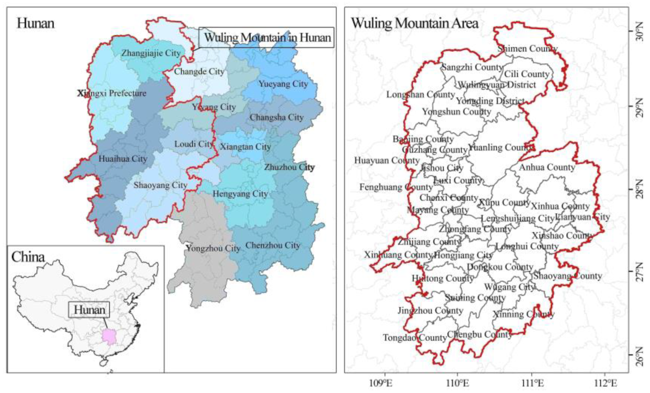
2.1. Study Areas

The area investigated in this work is the Wuling Mountains in Hunan Province, with a geographic location of 108°48′24″ E~111°54′51″ E, 25°52′58″ N~30°7′42″ N, including Xiangxi Prefecture; Huaihua City; Zhangjiajie City; and Xinshao, Shaoyang, Longhui, Dongkou, Suining, Xinning, Chengbu, Wugang in Shaoyang City; Xinhua, Lianyuan, Lengshuijiang in Loudi City; Shimen in Changde City; and Anhua in Yiyang City, with a total area of 86,000 km2 (Figure 1). As of 2020, the total regional population is 18.9109 million, of which the minority population accounts for 34%, mainly including Miao, Tujia, Dong, and Yao. The area also has world and national natural and cultural heritages, such as the Wulingyuan Natural Scenic Area, Xiangxi Global Geopark, Laosi City, and Fenghuang Ancient City. At the same time, numerous traditional villages with rich ethnic characteristics can be found. Since the announcement of the first batch of traditional villages in 2012, a total of six batches of 462 traditional Chinese villages in the region have been selected, including 376 ethnic minority traditional villages. This article uses these 462 national traditional villages as research objects and conducts experimental analysis.

2.2. Methods

2.2.1. Nearest Neighbor Index

The nearest point index can well reflect the spatial distribution characteristics of point elements, and the specific spatial distribution types are randomness, clustering, and equilibrium. Therefore, traditional villages are abstracted as points at the macro scale in this work, and the spatial distribution characteristics of traditional villages are judged by the nearest neighbor index. The calculation formula is follows:
D = d 1 ¯ d E ¯
In the formula, D is the nearest neighbour index, d 1 ¯ is the average value of the nearest distance, and d E ¯ is the theoretical nearest distance.

2.2.2. Standard Deviation Ellipse

The standard deviation ellipse can describe the overall outline and dominant direction of point elements in space. The long axis of the ellipse represents the distribution direction of point elements, whereas the short axis represents the distribution range of point elements. The greater the difference in axis length, the more pronounced the direction. The calculation formula is follows:
Ellipse center coordinates:
X = i = 1 n x i n ,   Y = i = 1 n y i n
In the formula, x i and y i are the spatial position coordinates of each element.
Ellipse rotation angle:
tan θ = i = 1 n X ¯ i = 1 n Y ¯ + ( i = 1 n X 2 ¯ i = 1 n Y 2 ¯ ) + 4 i = 1 n X Y ¯ 2 i = 1 n X Y ¯
In the formula, X ¯ and Y ¯ are the difference between the average center and X, Y coordinates.

2.2.3. Kernel Density Analysis

Kernel density analysis can reflect the clustering of point elements in space. Through such an analysis, not only can the clustering core of point elements be identified, but the density value of each point element can also be calculated. The calculation formula is as follows:
f ( x 1 ) = 1 n r j = 1 n k ( x 1 x j r )
In the formula, f ( x 1 ) is the kernel density value of point elements; r is the bandwidth. k represents the spatial weight function; n is the number of points whose distance from x 1 is less than or equal to r ; x 1 x j is the distance between x 1 and x j .

2.2.4. MGWR

MGWR was first proposed by Professor Fotheringham’s team [42] and it is mainly used to explore the spatial relationship between a dependent variable and an explanatory variable. Compared with the ordinary least square (OLS) method, spatial heterogeneity can be evaluated more reliably. Compared with the classic GWR model, different bandwidths can be formed according to different variables, thus reflecting different spatial scales. The calculation formula is as follows:
y i = β h ( x i , y i ) + j = 1 k β j ( x i , y i ) x i j + ϵ i
In the formula, y i is the global variable; ( x i , y i ) is the spatial coordinate of point i ; β h ( x i , y i ) is regression constant term; β j ( x i , y i ) represents the regression coefficient of point j ; x i j is the value of independent variable j ; k is the number of independent variables and ϵ i is the residual.

2.3. Data Sources

Data come from the website of traditional Chinese villages, from which six batches of 462 national-level traditional villages belonging to the Wuling Mountains region of Hunan Province are selected. Longitude and latitude information for these villages is determined using the image of tianditu and the place name search of Amap. A vector database is also constructed. Among them, the minority type data of 462 traditional villages are obtained from the team’s many years of field surveys.
In terms of influencing factors, on the basis of traditional influencing factors and considering the particularity of regional culture, this paper constructs a complete index system from the four aspects of nature, space, socioeconomics, and culture. Specifically, the woodland and arable land related to production and living, the density of intangible cultural heritage, and the density of cultural relic protection units related to regional culture are increased. Taking the core density value of each traditional village point element as the dependent variable of the regression model, 11 factors are used as explanatory variables to build regression models, namely, elevation, woodland, arable land, river system accessibility, transportation accessibility, urban accessibility, population density, per capita gross domestic product (GDP), density of intangible cultural heritage, density of cultural relic protection units, and proportion of minority population. The extraction and calculation methods of each explanatory variable are shown in Table 1.

3. Results

3.1. Spatial Heterogeneity

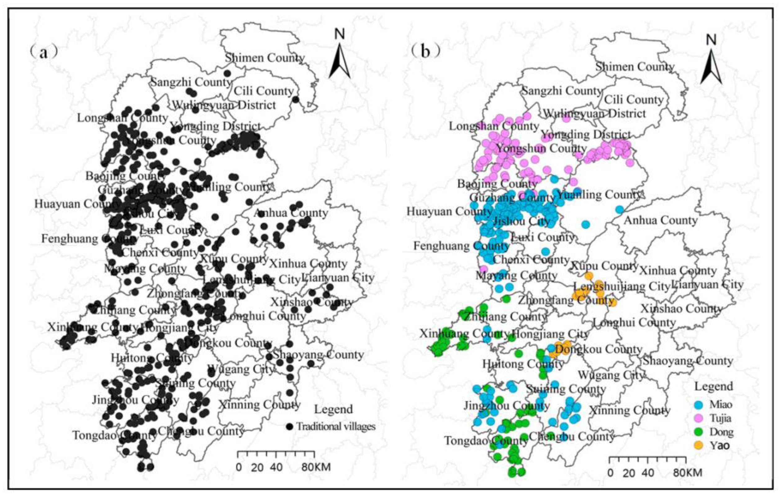
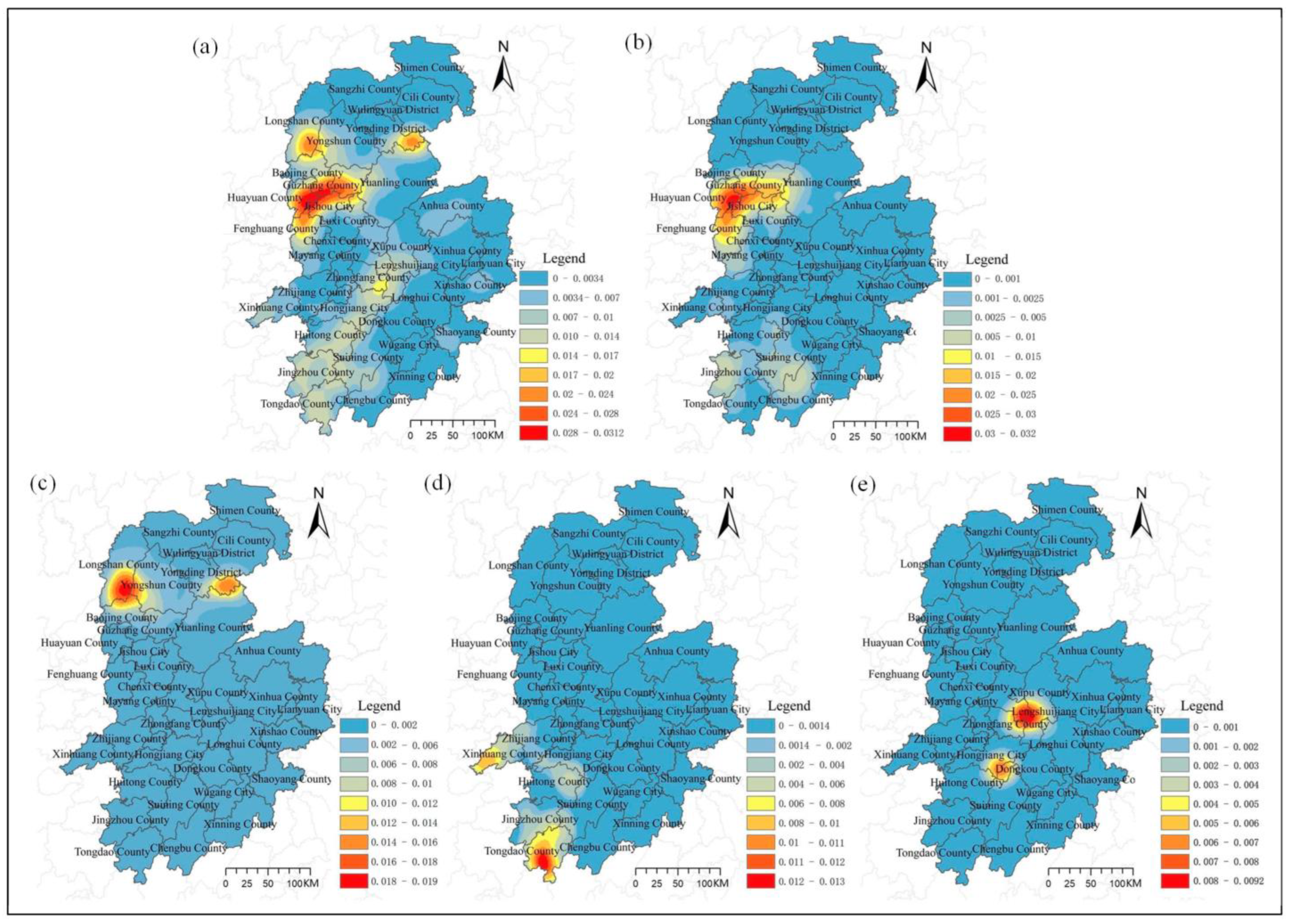
3.1.1. Clustering Features of Spatial Distribution

The nearest neighbor index is used to calculate the spatial clustering degree of traditional villages (Table 2). The nearest neighbor indexes ( D value) of the overall and each minority traditional village are less than 1, the Z value is negative, and the p value is less than 0.05, indicating that the spatial distributions of the overall and each minority traditional village reflect a significant clustering feature. From the perspective of each minority traditional village, the nearest neighbor index of traditional Miao villages is the smallest, indicating that the spatial clustering degree is more significant than other minorities.
First, from the overall perspective (Figure 2a), the nonequilibrium distribution features of “large dispersion and small agglomeration” are presented, mainly in Huaihua and Xiangxi. Among them, the number of traditional villages in Huaihua is the largest, with 187, accounting for 40.48% of the total number; followed by Xiangxi, 178, accounting for 38.53% of the total. Second, from the distribution of each minority traditional village, the total number of traditional Miao villages is 146, mainly in Huayuan County and Fenghuang County in Xiangxi Prefecture; the total number of traditional Tujia villages is 87, mainly distributed in Longshan County in Xiangxi Prefecture and Yongding District in Zhangjiajie City; the total number of traditional Dong villages is 59, mainly distributed in Tongdao County in Huaihua City; the total number of traditional Yao villages is 20, mainly distributed in Chenxi County in Huaihua City.

3.1.2. Directional Features of Spatial Distribution

The standard deviation ellipse method is used to calculate the spatial distribution trend of traditional villages (Table 3). A large difference is found between the ellipse long axis and the short axis of the spatial distribution of the overall and traditional Miao villages, indicating that the spatial distribution direction is obvious; the ellipse area of the overall and traditional Miao villages is large, indicating a wide range of spatial distribution, whereas the ellipse area of traditional Tujia, Dong, and Yao villages is small, suggesting that the spatial distribution is regionally strong.
In the spatial distribution direction (Figure 3), the spatial distribution of the overall traditional villages is in a north–south direction, specifically along the direction from Xiangxi Prefecture to Huaihua City. From the perspective of the distribution direction of each minority traditional village, the spatial distribution direction of traditional Miao villages is consistent with the overall; the spatial distribution of traditional Tujia villages is east–west, specifically from Zhangjiajie City to Xiangxi Prefecture; the spatial distribution of traditional Dong villages is northwest–southeast, mainly in the southwest of Huaihua City; and the spatial distribution of traditional Yao villages is northeast–southwest, mainly distributed near the Xuefeng Mountain.

3.1.3. Structural Features of Spatial Distribution

Kernel density is used to calculate the spatial structure features of traditional villages. After many experiments and comparisons, this study finds that when the search radius is 30 km, the expression effect is better. Therefore, the search radius is selected as 30 km to calculate kernel density (Figure 4). The spatial distribution of overall traditional villages presents the spatial characteristics of “one core, two sub-cores, and one axis”. Among them, the “one core” refers to Huayuan County, Fenghuang County, and Jishou City in Xiangxi Prefecture. The distribution density of traditional villages in this area reaches 0.032/km2. The “two sub-cores” are Longshan County in Xiangxi Prefecture and Yongding District in Zhangjiajie City. The distribution density of traditional villages in this area reaches 0.024/km2. The “one axis” is the southeast of Huaihua City, which is consistent with the main river basins, such as Lishui and Qu Shui. The spatial distribution of each minority traditional village has distinctly different density cores and density values. Among them, the density core of traditional Miao villages is consistent with the main core of the overall; the density core of the traditional Tujia village is consistent with the two sub-cores of the overall; the density core of traditional Dong and Yao villages constitutes the one axis of the overall. In general, minority traditional villages constitute the spatial structure characteristics of the overall traditional villages in the Wuling Mountain area of Hunan Province.

3.2. Influencing Factors

3.2.1. Model Comparison Analysis

Before the MGWR analysis, the OLS, classic GWR model and MGWR model are used for simulation, respectively, and the simulation results are compared (Table 4). The Koenker value in the OLS model analysis is significant, indicating that the study area has a large difference value with the change in variable, so a GWR model should be used for analysis. The R2 and A-R2 values of the MGWR model are the highest, whereas the AICc value is the lowest, indicating that its fitting results are the best. In terms of significance, the OLS model has only four significant factors: population density, per capita GDP, intangible cultural heritage, and proportion of minority population. In the analysis of the classic GWR model, only six factors of woodland, arable land, population density, per capita GDP, density of intangible cultural heritage, and proportion of minority population are significant. These results are not in line with expectations, suggesting that the influences of factors on the spatial distribution of traditional villages have large spatial heterogeneity and must be evaluated from different scales.

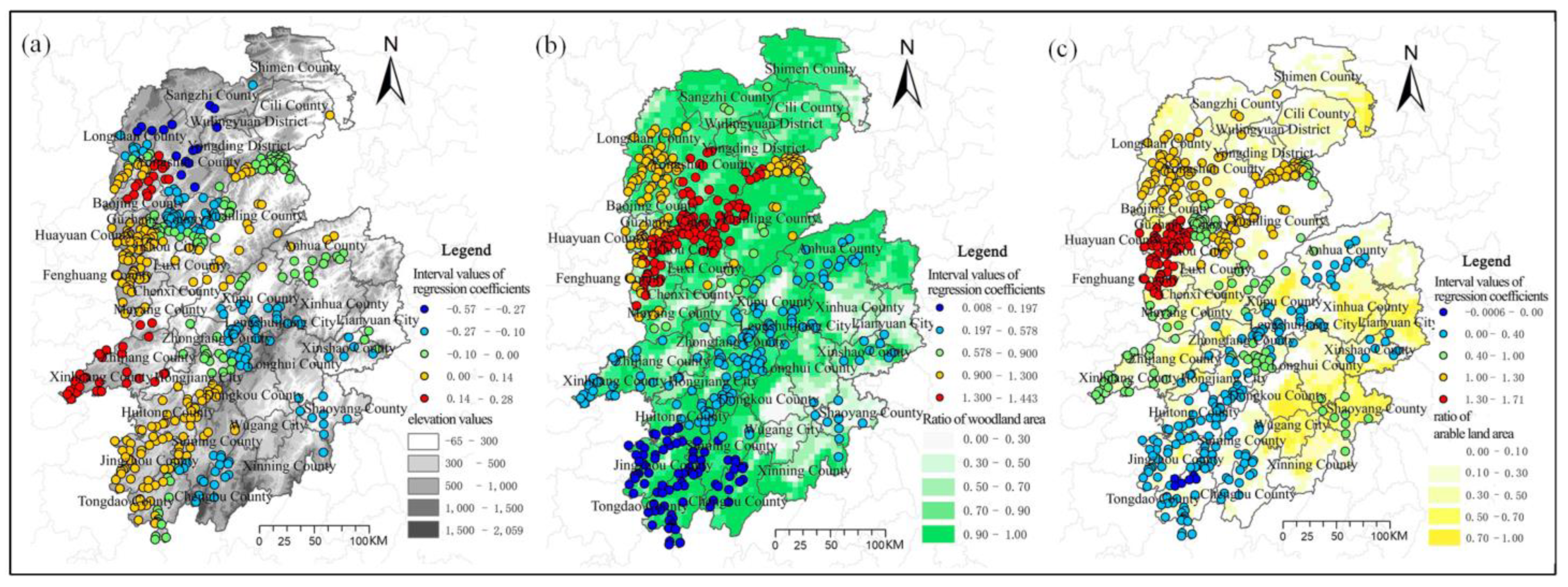
3.2.2. MGWR Model Result Analysis

Results of the regression model of natural factors (Table 5, Figure 5): from the perspective of the absolute value of the coefficient, the influence degree of the elevation factor is weak, and the influence degrees of woodland and arable land are moderate. First, in the elevation factor, only 24.77% of traditional villages have a significant correlation. From the perspective of positive and negative coefficients, elevation has a negative impact on the distribution of traditional villages, reflecting that the higher the altitude, the lower the number of traditional villages. From the perspective of spatial distribution, negative high-value areas mainly appear in the Wuling Mountains and Xuefeng Mountains. The terrain is relatively high and undulating in this area. Traditional villages are mostly distributed on the mountainside or at the foot of the mountain, showing the characteristics of building along the mountain. Second, in the woodland factor, 87.96% of traditional villages have a significant correlation. From the perspective of positive and negative coefficients, woodland has a significant positive impact on the distribution of traditional villages. From the perspective of spatial distribution, positive high-value areas mainly appear in the northwest of the Wuling Mountains. This area is a natural ecological reserve with less external disturbance, so traditional villages are well preserved. Last, in the arable land factor, 81.25% of traditional villages have a significant correlation. From the perspective of positive and negative coefficients, arable land has a significant positive impact on the distribution of traditional villages, reflecting that traditional villages are highly dependent on agricultural production. From the perspective of spatial distribution, positive high-value areas mainly appear in Xiangxi Prefecture. Although the area is mountainous and hilly, traditional villages are mostly located in a gentle area suitable for agricultural production and life.
Results of the regression model of spatial factors (Table 5, Figure 6): from the perspective of the absolute values of coefficients, the influences of the three factors are weak. First, in the river system factor, 16.43% of traditional villages have a significant correlation. From the perspective of positive and negative coefficients, the river system has a positive impact on the distribution of traditional villages, indicating that most traditional villages in the Wuling Mountain area in Hunan Province are far away from the water system. From the perspective of spatial distribution, positive high-value areas are mainly distributed in the Xuefeng Mountains, where few river systems can be found. Negative high-value areas are mainly distributed in river systems, such as Yuanshui, Youshui, Wushui, Huayuanhe, and Tuojiang. Developed river systems provide a guarantee for the life of traditional villages, showing the dependence of traditional villages on water. Second, in the transportation factor, only 10.88% of traditional villages have a significant correlation, suggesting that the distribution of traditional villages has little correlation with the transportation factor. From the perspective of positive and negative coefficients, transportation has a negative impact on the distribution of traditional villages, indicating that with the construction of road facilities, the distribution becomes close to the main road. Developed transportation can strengthen the connection between traditional villages and the outside world to achieve economic development, but it should avoid being assimilated and destroyed by the outside world. Last, for the urban factor, 56.02% of traditional villages are significantly correlated. From the perspective of positive and negative coefficients, urban areas have positive impacts on the distribution of traditional villages. From the perspective of spatial distribution, positive high-value areas are mainly distributed in the Xuefeng Mountain area, which has more mountains and fewer central cities, avoiding the impacts of modern lifestyles on traditional villages.
Results of the regression model of socioeconomic factors (Table 5, Figure 7): from the perspective of the absolute values of coefficients, two factors have strong degrees of influence. First, in the population density factor, 100.00% of traditional villages have a significant correlation. From the perspective of positive and negative coefficients, population density has a significant negative impact on the distribution of traditional villages. From the perspective of spatial distribution, negative high-value areas mainly appear in Guzhang County and Baojing County in Xiangxi Prefecture and Tongdao County in Huaihua City. These areas have low population densities and many traditional villages. On the one hand, in areas with small populations, the corresponding human activities are fewer, which avoids the destruction of traditional village buildings and spatial patterns; on the other hand, the population of traditional villages is outflowing, and the hollowing problem is serious. Second, in the per capita GDP factor, 87.5% of traditional villages have a significant correlation. From the perspective of positive and negative coefficients, per capita GDP has a negative impact on the distribution of traditional villages, showing the relatively backward economic development level; the more stable the human–land relationship, the more conducive to the reservation of traditional villages. Moreover, a positive correlation is observed in Jishou City in Xiangxi Prefecture and Yongding District in Zhangjiajie City. Given good local economic conditions, the government has invested a huge amount of funds for tourism development, thereby promoting the protection of traditional villages.
Results of the regression model of cultural factors (Table 5, Figure 8): from the perspective of the absolute values of coefficients, the density of intangible cultural heritage and the proportion of minority populations have relatively high degrees of influence, whereas the degree of influence of the density of the cultural preservation unit is relatively weak. First, in the density of intangible cultural heritage, 54.17% of traditional villages have a significant correlation. From the perspective of positive and negative coefficients, the density of intangible cultural heritage has a significant positive impact on the distribution of traditional villages. From the perspective of spatial distribution, positive high-value areas mainly appear in Xiangxi Prefecture. In 2010, Xiangxi Prefecture was established by the Ministry of Culture as the “Experimental Zone for Tujia and Miao Cultural Ecological Protection in Wuling Mountains (Xiangxi)”. The unique national culture and living habits have produced a large amount of intangible cultural heritage, thus enriching the connotation of traditional villages. Second, in the density of cultural preservation units, 20.83% of traditional villages have a significant correlation. From the perspective of positive and negative coefficients, the density of cultural preservation units has a positive impact on the distribution of traditional villages. From the perspective of spatial distribution, positive high-value areas mainly appear in the Xuefeng Mountains and the Wuling Mountains. The Xuefeng Mountains were an important battlefield of the Red Army during the Long March, leaving many important war relics. The Wuling Mountains are a concentrated area of ethnic culture where cultural preservation units are dense, and the number of traditional villages is correspondingly large. Last, in the proportion of minority populations, 68.52% of traditional villages have a significant correlation. From the perspective of positive and negative coefficients, the proportion of minority populations has a significant positive impact on the distribution of traditional villages. From the perspective of spatial distribution, positive high-value areas mainly appear in Xiangxi Prefecture where minority populations account for more than 70%, mainly including Miao and Tujia. These minorities advocate nature and blood, and most of them live together to form a traditional settlement with strong blood relationships. This stable settlement model also reduces external interference and preserves its own cultural characteristics well.

4. Discussion and Conclusions

4.1. Discussion

4.1.1. Influencing Factors of the Spatial Distribution of Traditional Villages

First, the long-term preservation of traditional villages in the Wuling Mountains in Hunan Province lies not only in the internal characteristics of traditional villages but also in the relationship between traditional villages and the external environment. Traditional villages are generally located in areas with superior natural conditions and rich resources, and the most prominent feature is that they are convenient for nearby production. Policies that let farmers go to cities and stay away from lands seriously violate the development rules of traditional villages and seriously affect the inheritance of traditional farming culture. To facilitate the production and living activities of traditional villages, the site selection of traditional villages has obvious distribution characteristics, mainly located in relatively low-altitude gentle areas suitable for farming. Therefore, natural conditions are the basic driving forces for the formation and development of traditional villages. Second, the small population and backward economy ensure the stability of the human–land relationship and avoid damage to the cultural values of traditional villages. At the same time, with the drive of urbanization and industrialization, many young people in rural areas are flowing out, which makes the traditional villages lack the main body of life and production, intensifies the impact on the traditional village economy, and greatly affects the protection and inheritance of traditional villages. Therefore, socioeconomic factors have a dual impact on the formation and development of traditional villages. Finally, the space distribution of traditional villages in the Wuling Mountains in Hunan Province is significantly more affected by the minority population and culture than in other regions. Most of these villages have a history of hundreds or even thousands of years, and during the historical development process they used their traditional skills and survival wisdom to create intangible culture represented by construction technology, clothing, language, and folk songs and dances. Thus, minority culture enriches the connotation of traditional villages, increases the charm of traditional villages, and is a key factor in the inheritance and development of traditional villages.

4.1.2. Strategies for the Protection and Development of Traditional Villages

The distribution of traditional villages is the result of the interactions among various factors, and each factor has a different degree of influence on traditional villages. Each village should classify traditional village types comprehensively and systematically by identifying the main factors to put forward targeted measures for protection and development. For example, the Wuling Mountain area in Hunan is one of the areas where ethnic minorities are concentrated in China. Local residents should be fully mobilized to participate in ethnic cultural protection. At the same time, local governments should vigorously promote the minority culture and develop tourism. For villages that have become tourist attractions, further attention should be paid to the protection of the original features of traditional villages, and the damage to their authenticity must be avoided as far as possible by tourist numbers, facility construction, and various economic activities. For traditional villages with poor economic conditions and backward transportation facilities, support from the government and all walks of life should be strengthened. Attention should be paid to local resource excavation, and the characteristics and industries of rich people must be strengthened to improve the livelihoods of people. For example, tangible and intangible cultural heritages are the natural values of traditional villages. Finding the transformation paths of these values can improve the self-development abilities of villages. In addition, strengthening the transportation links between traditional villages and the outside world is necessary to create conditions for their sustainable development. Considering the roles of external environmental factors, traditional villages close to cities must be prevented from being assimilated, and thereby losing their characteristics.
The protection and development of traditional villages are facing multiple problems, including the insufficient protection of traditional villages in existing laws and regulations, imperfect management systems, inadequate preparation of protection planning, and weak local protection awareness. First, laws and regulations should be further improved so that traditional village protection can be based on laws. At the same time, each village must work out their protection and development planning to guide their development and construction. Second, the census of traditional villages must be improved, their classified and graded protection and management should be implemented, and their protection must be incorporated into the political performance assessment system. Third, the protection of core values of traditional villages should be analyzed not only from the perspective of the region but also from the perspectives of local nature, culture, and nation; such protection must be accurately analyzed and evaluated. Finally, the traditional concept of villagers should be changed, and they must be guided to participate in the protection of traditional villages; in this way, they realize that preserving the cultural values and original features of villages is beneficial to them.

4.1.3. Research Limitations and Future Works

Previous studies on spatial patterns of traditional villages using GIS analysis and quantitative models achieved remarkable results. However, due to the limitations of research perspectives and methods, the present study is based on the overall and each minority perspective and uses a series of GIS spatial analysis methods and MGWR models to explore the spatial distribution characteristics and influencing factors of traditional villages in the Wuling Mountain area of Hunan Province, thus providing overall theoretical support for the protection and development of traditional villages. In addition, this research has some deficiencies. For example, the acquisition of data on socioeconomic and cultural factors is based on counties. Although such data can reflect regional differences, the differences among traditional villages cannot be determined. The next step will be to study the internal characteristics and spatiotemporal evolution of traditional villages from a micro-scale and further explore the spatial characteristics of traditional villages, including the adaptation mechanism to nature, socioeconomics, and culture.

4.2. Conclusions

The main contribution of this study is the use of the GIS spatial analysis method to explore the spatial distribution patterns of six batches of traditional villages from different perspectives. The second is the establishment of a potential influencing factors index system and the idea of using the MGWR model to simulate the spatial distribution mechanism of traditional villages. To verify the applicability of the MGWR model, different simulation methods, such as OLS and classic GWR, are introduced. The real data of six groups of traditional villages in the Wuling Mountain area of Hunan Province are used for the experiment. The results are as follows:
First, in terms of spatial distribution, obvious spatial differences are observed among traditional villages in the Wuling Mountain area of Hunan Province, and minority traditional villages reflect the spatial characteristics of overall traditional villages in the same area. (1) In terms of the degree of spatial aggregation, the spatial distributions of the overall and each minority traditional village show significant clustering characteristics, among which traditional Miao villages have the highest degree of agglomeration; (2) In terms of spatial distribution, the spatial distribution of traditional Miao villages is wide, mainly located in Xiangxi Prefecture and Huaihua City, and traditional Tujia, Dong, and Yao villages have small spatial distributions and strong regional characteristics. Among them, Tujia is mainly located in Xiangxi Prefecture and Zhangjiajie City, whereas Dong and Yao are located in Huaihua City; (3) In terms of spatial structure, the overall and each minority traditional village have formed obvious density cores, and among them traditional Miao and Tujia villages constitute the primary and secondary cores of the overall traditional villages. The core locations are Jishou City, Huayuan County, and Fenghuang County in Xiangxi Prefecture; Longshan County in Xiangxi Prefecture; and Yongding District in Zhangjiajie City.
Second, in terms of influencing factors: (1) From the aspect of influence scale, the influence of each factor on the spatial distribution of traditional villages has a strong spatial heterogeneity. According to the influence scale from small to large, the order is arable land, urban, population density, density of intangible cultural heritage, density of cultural relic protection units, proportion of minority population, per capita GDP, woodland, river system, elevation, and transportation. Among them, water system, elevation, and transportation are global scales, and the spatial distribution differences are weak; (2) From the aspect of impact intensity, the most relevant factors are per capita GDP, density of intangible cultural heritage, proportion of minority population, arable land, population density, and woodland. Among them, natural factors are the basic factors affecting the spatial distribution of traditional villages and the overall positive correlation. For example, traditional villages are mainly distributed in mountain forest areas with good ecological environments and rely heavily on traditional farming production methods; spatial factors have no significant impact on the distribution of traditional villages; the impacts of socioeconomic factors on the spatial distribution of traditional villages are dual, including the overall negative correlation. For example, the low population density and backward economic level ensure the stability of the human–land relationship and promote the preservation of traditional villages. However, they impede the sustainable development of traditional villages, leading to their gradual extinction. Cultural factors are the key to the spatial distribution of traditional villages and generally have a positive correlation, and the two have a mutual promotion. Multiethnic and other regional cultural characteristics have left rich material and nonmaterial resources for the region; these resources are the concentrated embodiment of the soul of traditional villages. In short, the formation of the spatial patterns of traditional villages in the Wuling Mountain area of Hunan Province is the result of long-term interactions among various factors, such as nature, socioeconomic aspect, and culture. This study effectively explores the spatial distribution characteristics and influencing mechanisms of traditional villages in the Wuling Mountain area of Hunan Province. It also provides a decision-making basis for the cross-regional protection and sustainable development of traditional villages.

Author Contributions

Conceptualization, T.L. and C.L.; methodology, T.L. and C.L.; software, T.L. and R.Z.; validation, T.L. and R.Z.; formal analysis, T.L.; investigation, Z.C. and Y.M.; resources, Z.C. and Y.M.; data curation, T.L. and Z.C.; writing—original draft preparation, T.L. and R.Z.; writing—review and editing, T.L., C.L. and Z.C.; visualization, T.L., R.Z. and Y.M.; supervision, C.L.; project administration, T.L. and C.L. All authors have read and agreed to the published version of the manuscript.

Funding

This research was funded by the “National Natural Science Foundation of China”, grant number 42171418, “Social Science Achievement Review Committee of Hunan Provincial, China”, grant number XSP21YBZ068 and “Social Science Achievement Review Committee of Hunan Provincial, China”, grant number XSP20YBZ074.

Data Availability Statement

Not applicable.

Acknowledgments

The authors are thankful to reviewers for their insightful comments and suggestions to an earlier edition of this article.

Conflicts of Interest

The authors declare no conflict of interest.

References

  1. Hu, B.; Deng, X. The Origin and Early development of Chinese villages. Seeker 2019, 1, 151–160. [Google Scholar]
  2. Jiang, D.; Peng, C. The Phenomenon of Rural Declining in the Process of Urbanization: Causes and Governance—An Analysis from the Perspective of the Implementation of “Rural Revitalization Strategy”. J. Nanjing Audit Univ. 2018, 15, 16–24. [Google Scholar]
  3. Hu, Y.; Chen, S.; Cao, W. The Concept and Cultural Connotation of Traditional Villages. Urban Dev. Stud. 2014, 21, 10–13. [Google Scholar]
  4. The Ministry of Housing and Urban–Rural Development, the Ministry of Culture, and the Ministry of Finance Jointly Announced the First Batch of Traditional Chinese Villages. Available online: http://www.chuantongcunluo.com/index.php/Home/gjml/gjml/wid/587.html (accessed on 12 January 2023).
  5. The CPC Central Committee and the State Council Issued the Strategic Plan for Rural Revitalization (2018–2022). Available online: http://www.gov.cn/xinwen/2018-09/26/content_5325534.htm (accessed on 12 January 2023).
  6. Rao, X.; Zhou, J.; Ding, K.; Wang, J.; Fu, J.; Zhu, Q. Research on the Cultural Tracing of the Patriarchal Clan System of Traditional Buildings in the Eastern Zhejiang Province, China, Based on Space Syntax: The Case Study of Huzhai in Shaoxing. Sustainability 2022, 14, 7247. [Google Scholar] [CrossRef]
  7. Karol, K. The Scarecrow as Part of Polish Rural Cultural Landscapes. Agriculture 2020, 10, 496. [Google Scholar] [CrossRef]
  8. Peng, Y.; Ma, Z.; Zhu, D.; Liu, Z.; Meng, Q. Protection and Ecology Planning Strategy of Traditional Village Heritage, Take the Chen Lou Village as an Example. EKOLOJI 2019, 28, 921–928. [Google Scholar]
  9. Kouřilová, J.; Pělucha, M.; Kouřilová, J.; Pělucha, M. Economic and Social Impacts of Promoting Cultural Heritage Protection by the Czech Rural Development Programme 2007–2013. Eur. Countrys. 2017, 3, 468–503. [Google Scholar] [CrossRef] [Green Version]
  10. Dobrovodská, M.; Kanka, D.; David, S.; Kollár, J.; Špulerová, J.; Štefunková, D.; Mojses, M.; Petrovič, F.; Krištín, A.; Stašiov, S.; et al. Assessment of the biocultural value of traditional agricultural landscape on a plot-by-plot level: Case studies from Slovakia. Biodivers. Conserv. 2019, 28, 2615–2645. [Google Scholar] [CrossRef]
  11. St’astna, M.; Vaishar, A. Values of rural landscape: The case study Chlum u Trebone (Bohemia). Land Use Policy 2020, 97, 104699. [Google Scholar] [CrossRef]
  12. Gorka, A. Threats to Rural Landscape and Its Protection in Poland. Environments 2018, 5, 109. [Google Scholar] [CrossRef] [Green Version]
  13. Gorączko1, M.; Aleksandra, C. Vernacular architecture and traditional rural landscape in new socio-economic realities—A case study from Central Poland. Bull. Geography. Socio-Econ. Ser. 2015, 30, 43–58. [Google Scholar] [CrossRef] [Green Version]
  14. Wang, W.; Watanabe, M.; Ono, K.; Zhou, D. Exploring Visualisation Methodology of Landscape Design on Rural Tourism in China. Buildings 2022, 12, 64. [Google Scholar] [CrossRef]
  15. Šťastná, M.; Vaishar, A.; Ryglová, K.; Rašovská, I.; Zámečník, S. Cultural Tourism as a Possible Driver of Rural Development in Czechia. Wine Tourism in Moravia as a Case Study. Eur. Countrys. 2020, 12, 292–311. [Google Scholar]
  16. Gao, J.; Wu, B. Revitalizing traditional villages through rural tourism: A case study of Yuanjia Village, Shaanxi Province, China. Tour. Manag. 2017, 4, 223–233. [Google Scholar] [CrossRef]
  17. Meng, Q.; Wang, C.; Xu, T.; Pi, H.; Wei, Y. Evaluation of the Sustainable Development of Traditional Ethnic Village Tourist Destinations: A Case Study of Jiaju Tibetan Village in Danba County, China. Land 2022, 11, 1008. [Google Scholar] [CrossRef]
  18. Fazio, S.; Modica, G. Historic Rural Landscapes: Sustainable Planning Strategies and Action Criteria. The Italian Experience in the Global and Eu-ropean Context. Sustainability 2018, 10, 3834. [Google Scholar]
  19. Liu, S.; Ge, J.; Bai, M.; Yao, M.; He, L.; Chen, M. Toward classification-based sustainable revitalization: Assessing the vitality of traditional villages. Land Use Policy 2022, 116, 106060. [Google Scholar] [CrossRef]
  20. Xiao, Y.; Zhao, J.; Sun, S.; Guo, L.; Axmacher, J.; Sang, W. Sustainability Dynamics of T raditional Villages: A Case Study in Qiannan Prefecture, Guizhou, China. Sustainability 2020, 12, 314. [Google Scholar] [CrossRef] [Green Version]
  21. Nie, Z.; Li, N.; Pan, W.; Yang, Y.; Chen, W.; Hong, C. Quantitative research on the form of traditional villages based on the space gene—A case study of Shibadong village in western Hunan, China. Sustainability 2022, 14, 8965. [Google Scholar] [CrossRef]
  22. Figlus, T. Process of Incorporation and Morphological Transformations of Rural Settlement Patterns in the Context of Urban Development. The Case Study of Łódź. Quaest. Geogr. 2020, 39, 75–95. [Google Scholar]
  23. Bian, J.; Chen, W.; Zeng, J. Spatial Distribution Characteristics and Inflfluencing Factors of Traditional Villages in China. Int. J. Environ. Res. Public Health 2022, 19, 4627. [Google Scholar] [CrossRef]
  24. Wu, Y.; Wu, M.; Wang, Z.; Zhang, B.; Li, C.; Zhang, B. Distribution of Chinese traditional villages and influencing factors for regionalization. Ciência Rural. 2021, 51, e20200368. [Google Scholar] [CrossRef]
  25. Jin, J.; Yan, H. Analyzing the Causes of Spatial Differentiation of the Traditional Villages in Gansu Province, Western China. J. Geosci. Environ. Prot. 2020, 8, 12–25. [Google Scholar] [CrossRef]
  26. Yang, Y.; Hu, J.; Liu, D. Spatial difterentiation of ethnic traditional villages in Guizhou province and thenfluencing factors. J. Arid Land Resour. Environ. 2022, 36, 175–178. [Google Scholar]
  27. Liu, S.; Bai, M.; Yao, M.; Huang, K. Identifying the natural and anthropogenic factors influencing the spatial disparity of population hollowing in traditional villages within a prefecture-level city. PLoS ONE 2021, 16, e0249448. [Google Scholar] [CrossRef]
  28. Xu, Y.; Yang, X.; Feng, X.; Yan, P.; Shen, Y.; Li, X. Spatial distribution and site selection adaptation mechanism of traditional  villages along the Yellow River in Shanxi and Shaanxi. River Res. Appl. 2022, 4, 3977. [Google Scholar] [CrossRef]
  29. Xie, G.; Zhou, Y.; Liu, C. Spatial Distribution Characteristics and Inflfluencing Factors of Hakka Traditional Villages in Fujian, Guangdong, and Jiangxi, China. Sustainability 2022, 14, 12068. [Google Scholar] [CrossRef]
  30. Gao, C.; Wu, Y.; Bian, C.; Gao, X. Spatial characteristics and influencing factors of Chinese traditional villages in eight provinces the Yellow River flows through. River Res. Appl. 2021, 10, 3880. [Google Scholar] [CrossRef]
  31. Rosner, A.; Wesołowska, M. Deagrarianisation of the Economic Structure and the Evolution of Rural Settlement Patterns in Poland. Land 2020, 9, 523. [Google Scholar] [CrossRef]
  32. Fanta, V.; Beneš, J.; Zouhar, J.; Rakava, V.; Šitnerová, I. Ecological and historical factors behind the spatial structure of the historical field patterns in the Czech Republic. Sci. Rep. 2022, 12, 8645. [Google Scholar] [CrossRef]
  33. Sklenicka, P.; Šímová, P.; Hrdinová, K.; Salek, M. Changing rural landscapes along the border of Austria and the Czech Republic between 1952 and 2009: Roles of political, socioeconomic and environmental factors. Appl. Geogr. 2014, 47, 89–98. [Google Scholar] [CrossRef]
  34. Jończy, R.; Śleszyński, P.; Dolińska, A.; Ptak, M.; Rokitowska, J.; Rokita, D. Environmental and Economic Factors of Migration from Urban to Rural Areas: Evidence from Poland. Energies 2021, 14, 8467. [Google Scholar] [CrossRef]
  35. Hanna, B. The Determinants of The Existing Conditions on The Functional and Spatial Development of Rural Areas. Civ. Environ. Eng. Rep. 2022, 32, 255–268. [Google Scholar]
  36. Mazurek, K. Spatial Analyses in the Research of Land Cover Changes (A Case Study). Contemp. Trends Geosci. 2015, 4, 1–13. [Google Scholar] [CrossRef]
  37. Wang, Q.; Bing, H.; Wang, S.; Xu, Q. Study on the Spatial Distribution Characteristics and Inflfluencing Factors of Famous Historical and Cultural Towns or Villages in Hubei Province, China. Sustainability 2022, 14, 13735. [Google Scholar] [CrossRef]
  38. Liao, C.; Zuo, Y.; Law, R.; Wang, Y.; Zhang, M. Spatial Differentiation, Inflfluencing Factors, and Development Paths of Rural Tourism Resources in Guangdong Province. Land 2022, 11, 2046. [Google Scholar] [CrossRef]
  39. Tang, H.; Li, D. Spatial Distribution Characteristics of Fringe Villages of Archipelagic City: A Case Study of Zhoushan. J. Coast. Res. 2020, 103, 469–473. [Google Scholar] [CrossRef]
  40. Li, C.; Wu, K. Driving forces of the villages hollowing based on geographically weighted regression model: A case study of Longde County, the Ningxia Hui Autonomous Region, China. Nat. Hazards 2017, 89, 1059–1079. [Google Scholar] [CrossRef]
  41. Wang, J.; Li, X.; Christakos, G.; Liao, Y.; Zhang, T.; Gu, X. Geographical Detectors-Based Health Risk Assessment and its Application in the Neural Tube Defects Study of the Heshun Region, China. Int. J. Geogr. Inf. Sci. 2010, 24, 107–127. [Google Scholar] [CrossRef]
  42. Fotheringham, A.; Yang, W.; Kang, W. Multiscale Geographically Weighted Regression (MGWR). Am. Assoc. Geol. Yearb. 2017, 107, 1247–1265. [Google Scholar] [CrossRef]
  43. Zhu, H.; Ou, X.; Yang, Z.; Yang, Y.; Ren, H.; Tang, L. Spatiotemporal Dynamics and Driving Forces of Land Urbanization in the Yangtze River Delta Urban Agglomeration. Land 2022, 11, 1365. [Google Scholar] [CrossRef]
  44. Liao, X.; Deng, M.; Huang, H. Analyzing Multiscale Spatial Relationships between the House Price and Visual Environment Factors. Appl. Sci. 2022, 12, 213. [Google Scholar] [CrossRef]
  45. Wei, F.; Li, S.; Liang, Z.; Huang, A.; Wang, Z.; Shen, J.; Sun, F.; Wang, Y.; Wang, H.; Li, S. Analysis of Spatial Heterogeneity and the Scale of the Impact of Changes in PM2.5 Concentrations in Major Chinese Cities between 2005 and 2015. Energies 2021, 14, 3232. [Google Scholar] [CrossRef]
  46. The CPC Central Committee and the State Council issued the Outline of China’s Rural Poverty Alleviation and Development (2011–2020). Available online: http://www.gov.cn/gongbao/content/2011/content_2020905.htm (accessed on 12 January 2023).
Figure 1. Location of the Wuling Mountains in Hunan, China.
Buildings 13 00294 g001
Figure 2. Spatial distribution of traditional villages: (a) spatial distribution of overall traditional villages; (b) spatial distribution of each minority traditional village.
Buildings 13 00294 g002
Figure 3. Standard deviation ellipse of traditional villages: (a) standard deviation ellipse of overall traditional villages; (b) standard deviation ellipse of each minority traditional village.
Buildings 13 00294 g003
Figure 4. Kernel density of the traditional villages: (a) kernel density of the overall traditional villages; (b) kernel density of the traditional Miao villages; (c) kernel density of the traditional Tujia villages; (d) kernel density of the traditional Dong villages; (e) kernel density of the traditional Yao villages.
Buildings 13 00294 g004
Figure 5. Spatial distribution of regression coefficients of natural factors: (a) spatial distribution of regression coefficients of elevation factor; (b) spatial distribution of regression coefficients of woodland factor; (c) spatial distribution of regression coefficients of arable land factor.
Buildings 13 00294 g005
Figure 6. Spatial distribution of regression coefficients of space factors: (a) spatial distribution of regression coefficients of river system factor; (b) spatial distribution of regression coefficients of transportation factor; (c) spatial distribution of regression coefficients of urban factor.
Buildings 13 00294 g006
Figure 7. Spatial distribution of regression coefficients of socioeconomic factors: (a) spatial distribution of regression coefficients of population density factor; (b) spatial distribution of regression coefficients of per capita GDP factor.
Buildings 13 00294 g007
Figure 8. Spatial distribution of regression coefficients of cultural factors: (a) spatial distribution of regression coefficients of intangible cultural heritage factor; (b) spatial distribution of regression coefficients of cultural relics protection units factor; (c) spatial distribution of regression coefficients of minority population factor.
Buildings 13 00294 g008
Table 1. Extraction and calculation methods of influencing factors.
TypeIndexCalculation MethodData Sources
Natural factorElevationElevation values of point featuresGeospatial Data Cloud (DEM30m Data)
WoodlandThe ratio of woodland area to grid area of the grid where the point feature is locatedResource and Environmental Science and Data Center
Arable landThe ratio of arable land area to grid area of the grid where the point feature is located
Space factorRiver system accessibilityThe distance from the point feature to the nearest major river systemNational Catalogue Service For Geographic Information
Transportation accessibilityThe distance from the point feature to the nearest major highway. The highway mainly includes national highways, provincial highways, and county highways.
Urban accessibilityThe distance from the point feature to urban above county levelAmap
Socioeconomic factorPopulation densityThe population density of the county, district and city where the point feature is locatedHunan Bureau of Statistics website
Per capita gross domestic product (GDP)The per capita GDP of the county, district and city where the point element is located
Cultural factorDensity of intangible cultural heritageThe density of intangible cultural heritage in the county, district and city where the point element is locatedChina Intangible Cultural Heritage website, and Hunan People’s Government website
Density of cultural relics protection unitsThe density of cultural relics protection units in the county, district and city where the point element is locatedChinese Cultural Heritage Administration website, and Hunan People’s Government website
Proportion of minority populationThe proportion of minority population in the county, district and city where the point feature is locatedHunan Bureau of Statistics website
Table 2. Nearest neighbor index of the overall and each minority traditional village.
Type d 1 ¯ d E ¯ D p Value Z Spatial Distribution Type *
Overall5327.807680.130.690−12.59Clustering
Miao5411.818525.640.630−8.44Clustering
Tujia6234.428405.610.740−4.61Clustering
Dong6855.028348.590.760.008−2.62Clustering
Yao4694.836353.290.750.025−2.23Clustering
* When D = 1, the spatial distribution of traditional villages is random; when D > 1, the spatial distribution of traditional villages is clustered; when D < 1, the spatial distribution of traditional villages is equilibrated. When the p value is less than 0.05, it indicates that the spatial distribution of traditional villages is significant.
Table 3. Spatial layout ellipse parameters of the overall and each minority traditional village.
TypeLong Semi-Axis (km)Short Semi-Axis (km)Azimuth
(°)
Area
(km2)
Overall131.0680.504.1436,137.26
Miao120.4144.46177.6116,818.73
Tujia72.4330.1986.717020.61
Dong85.7236.87157.859929.32
Yao47.2212.4828.781851.72
Table 4. Comparison of indicators of ordinary least square model (OLS), classic geographical weighted regression model (GWR) and multiscale geographically weighted regression model (MGWR).
Diagnostic IndicatorsOLS ModelGWR ModelMGWR Model
R20.6170.6460.903
A-R20.6070.6340.876
AICc3440.69810.757353.066
Table 5. MGWR model result.
TypeIndexBandwidthSignificanceMaximum Value of Regression Coefficient Minimum Value of Regression CoefficientPositive Regression Coefficient PercentageNegative Regression Coefficient Percentage
Natural FactorElevation36624.77%0.283−0.57348.84%51.16%
Woodland8887.96%1.4430.009100.00%0.00%
Arable land4381.25%1.716−0.00199.77%0.23%
Space factorRiver system accessibility39916.43%0.171−0.19154.63%45.37%
Transportation accessibility39910.88%0.152−0.22434.72%65.28%
Urban accessibility4356.02%0.471−0.30975.46%24.54%
Socioeconomic factorPopulation density43100.00%−0.058−1.6130.00%100.00%
Per capita GDP8687.5%0.536−2.27931.94%68.06%
Cultural factorDensity of intangible cultural heritage4354.17%1.803−0.33384.26%15.74%
Density of cultural relics protection units4320.83%0.723−0.86152.31%47.69%
Proportion of minority population4368.52%1.753−0.62984.72%15.28%
Disclaimer/Publisher’s Note: The statements, opinions and data contained in all publications are solely those of the individual author(s) and contributor(s) and not of MDPI and/or the editor(s). MDPI and/or the editor(s) disclaim responsibility for any injury to people or property resulting from any ideas, methods, instructions or products referred to in the content.

