1. Introduction
With the rapid growth of global communication demands, especially in remote areas, maritime regions, and airborne platforms where terrestrial networks face significant deployment challenges, satellite communications have become an indispensable strategic extension and supplement to ground-based systems. Geostationary Earth orbit (GEO) satellites, as the cornerstone of high-orbit communication infrastructures, offer broad coverage, stable link performance, and low-cost ground terminals, making them essential in key application areas such as broadcasting, distance education, emergency communications, and military operations [
1]. Currently, countries and regions (such as the United States, Europe, China, and Russia) are prioritizing the development of GEO satellite systems. These efforts involve the deployment of next-generation high-throughput satellites to deliver greater capacity at reduced costs. Concurrently, international standardization efforts are accelerating. The international telecommunication union (ITU) plays a critical role in the global coordination and management of GEO orbital and spectrum resources, while the 3rd Generation Partnership Project (3GPP) is spearheading the standardization of 5G non-terrestrial networks (NTNs). These initiatives aim to integrate GEO with medium Earth orbit (MEO) and low Earth orbit (LEO) satellite systems into a unified mobile communication framework [
2], ultimately fostering a fully integrated space–air–ground communication network that supports global digital connectivity and reinforces national strategic security.
Due to the high cost, complex design, and wide coverage requirements, simulation platforms are critical to GEO satellite communication systems. Simulation supports orbit and constellation design, link analysis [
3], coverage evaluation [
4], and resource scheduling optimization [
5,
6], helping reduce trial-and-error costs and enhance system reliability. In recent years, extensive research on the modeling and simulation of GEO satellite communication systems has been conducted by both academia and industry. For example, the National Aeronautics and Space Administration (NASA) developed the SATCOM Modeling Tool (SMT), which facilitates satellite constellation design, communication link simulation, and resource scheduling tests. Similarly, the European Space Agency (ESA) introduced the SatNetSim system to assess end-to-end communication performance within multi-orbit satellite network architectures. In addition, the Chinese Academy of Sciences has proposed an integrated space–air–ground information network test platform based on cloud-native technologies [
7].
The GEO satellite communication simulation system primarily comprises four core modules: orbit and constellation modeling, communication link modeling, coverage analysis, and resource management and scheduling. Their functional roles, data flows between them, and the representative simulation tools adopted for each module are illustrated in
Figure 1. Orbit and constellation modeling is responsible for generating and updating the trajectories and constellation configurations to provide essential geometric and spatiotemporal data for the overall simulation. Currently, modeling techniques have become increasingly precise [
8]. The communication link modeling module, which integrates the functions of traditional physical layer communication modeling and channel modeling, is primarily used to estimate key link performance parameters such as path loss, link margin, and available throughput. Typically driven by parameter tables, this module employs models such as free-space path loss, standard atmospheric attenuation, and empirical formulas, providing reliable support for performance evaluation at the system level [
9,
10]. Among these components, the coverage analysis module and the resource management and scheduling module serve as the core pillars for performance evaluation and strategy validation, making them the most critical components of the entire simulation system.
The coverage analysis module is primarily used to determine whether satellite beams can effectively serve ground terminals. It provides key metrics such as service duration, spatial accessibility of beams, and overlapping coverage areas [
7]. This module directly impacts the effectiveness of downstream components such as communication link modeling and resource management and scheduling, serving as the spatial foundation for system performance evaluation and strategy validation. Current coverage analysis technologies are relatively mature, which are, with well-established modeling methods and tool support, suitable for most system-level simulations. However, they still face significant challenges in handling highly complex scenarios involving intelligent and flexible beam control.
The resource management and scheduling module performs intelligent allocation of resources for multiple services with varying priorities, directly impacting the system’s service efficiency and resource utilization. Consequently, resource management and scheduling have emerged as a critical and indispensable core technology. However, with rapidly escalating user demands and increasingly diverse service types, there is a pronounced conflict between the limited availability of resources (such as beams, power, and time slots) and the dynamic nature of service tasks. Traditional resource planning mechanisms based on static configurations and rule-driven strategies lack unified modeling and dynamic scheduling, making it difficult to handle multiple tasks and heterogeneous resources. This limitation results in challenges with resource conflicts, shifting service demands, and changing task priorities, which in turn lead to lower resource utilization rates and diminished communication quality.
In summary, a diverse array of GEO satellite communication simulation platforms has been developed to support various aspects such as system-level link analysis, beam coverage evaluation, and resource scheduling. However, a comprehensive summary that critically reviews and compares these platforms is notably lacking. This article aims to fill that gap by providing an in-depth overview of GEO satellite communication simulation systems, detailing coverage analysis, resource management and scheduling, and reviewing typical simulation platforms and tools. Rather than developing a standalone simulation platform, this study proposes a modular and extensible co-simulation framework tailored for GEO satellite systems. It integrates widely adopted tools and unifies geometry-based visibility modeling, co-simulation interfaces, and resource-aware scheduling strategies. This design facilitates cross-layer planning, tool reuse, and adaptation to dynamic satellite communication scenarios. The main contributions of this article are summarized as follows:
As a critical component of GEO satellite communication systems, coverage analysis is first examined through its fundamental modeling elements and performance metrics. Four representative coverage analysis methods are then classified and reviewed with respect to their modeling complexity, computational efficiency, and adaptability to dynamic environments.
Resource management and scheduling play a pivotal role in supporting multi-service and highly dynamic applications, while enhancing overall system performance. This study categorizes and presents resource management and scheduling strategies from the perspective of key performance metrics.
To support a comprehensive evaluation of system performance, the most widely used simulation packages are overviewed to assist researchers and engineering practitioners in selecting appropriate simulation tools.
The rest is organized as follows. In
Section 2, coverage analysis is summarized.
Section 3 overviews resource management and scheduling. Simulation platforms and tools are presented in
Section 4. Conclusions are drawn in the last section.
2. Coverage Analysis
Coverage analysis plays a fundamental role in the design and evaluation of satellite communication systems. Accurate coverage assessment depends on multiple key modeling components, including satellite orbital parameters, antenna gain patterns, beam geometry, and environmental factors such as terrain elevation and atmospheric conditions. These elements collectively determine the spatial and temporal accessibility of satellite beams. To evaluate coverage performance, metrics such as accessibility (i.e., line-of-sight visibility, minimum elevation angle, and obstruction status), service time, spatial distribution (i.e., coverage footprint, blind zones, and overlapping regions), and Quality of Service (QoS) (i.e., signal-to-noise ratio (SNR), throughput, and link reliability), are commonly used. To support the planning, evaluation, and optimization of satellite communication systems, a variety of coverage analysis methods have been developed. These methods differ significantly in terms of modeling complexity, computational efficiency, and adaptability to dynamic environments. In this section, we categorize and review the representative coverage analysis approaches into four main classes: geometry-based methods, fast evaluation and approximate inference techniques, simulation-based modeling, and data-driven adaptive approaches.
2.1. Geometry-Based Visibility Analysis
Geometry-based visibility analysis determines line-of-sight visibility and elevation constraints based on the geometric relationship between satellites and ground terminals. In [
4], a novel approach using stochastic geometry was presented to model and analyze GEO satellite networks. The distribution of GEO satellites in the geostationary orbit was modeled using a binomial point process and satellite visibility was analyzed based on the terminal’s latitude. A characteristic area-based method for continuous coverage analysis was proposed in [
11], which modeled satellite visibility and coverage continuity through deterministic formulations derived from orbital trajectories and ground partitioning schemes. Li et al. proposed a geometry-based coverage evaluation in [
12], where capacity comparisons between adjacent and overlapping multi-beam patterns were derived under line-of-sight channel assumptions. Closed-form expressions for SNR and capacity were obtained, enabling theoretical insight into the beam arrangement’s impact on system performance. Focusing on improving the classical grid-point approach (GPA) for constellation-to-ground visibility evaluation, the authors in [
13] introduced strategies to estimate upper and lower bounds of coverage results and to refine high-precision results from low-precision computations by analyzing the spatial and temporal characteristics of GPA. These enhancements improved both the accuracy and efficiency of coverage analysis in satellite applications. In [
14], an analytical expression of the propagation delay within GEO satellite spot beams was derived based on the space geometry model. And differential propagation delays in several typical beams were calculated, according to a possible multi-beam coverage pattern of China.
2.2. Fast Evaluation Algorithms
In addition to conventional geometry-based methods, fast evaluation algorithms and approximate inference models have emerged to address the need for efficient coverage assessment. Chen et al. [
15] defined the coverage state function and the corresponding extension and intermediate modes for basic coverage analysis problems. Furthermore, an integrated coverage theory system is constructed by analyzing the properties of three basic spatial and temporal factors using parameter wildcard characters. To address large-scale connectivity challenges in IoT scenarios, stochastic geometry-based methods have been introduced for efficient availability analysis with low complexity and coverage performance estimates in [
16].
2.3. Simulation-Based Coverage Modeling
While fast evaluation algorithms offer computational efficiency, they may compromise accuracy in highly dynamic or complex scenarios. To address this, simulation-based coverage modeling provides an alternative to produce precise and realistic coverage assessments. For example, Zhang et al. [
17] demonstrated the effectiveness of simulation-based methods by integrating a Systems Tool Kit (STK) with MATLAB to evaluate satellite visibility and target coverage performance. By modeling both individual reconnaissance satellites and Walker constellation networks, the approach enabled comparative analysis of coverage effectiveness in maritime operational areas, supporting mission planning with high-fidelity simulation outputs.
2.4. Data-Driven Methods
Though geometric models and simulation tools like STK provide accurate assessments, they struggle with the complexity of intelligent and flexible beam control. As satellite systems become more dynamic and adaptive, data-driven methods are increasingly applied to enhance efficiency and accuracy in these challenging scenarios. For example, by leveraging the spatial clustering of user terminals, an adaptive multi-beam pattern and footprint plan were proposed in [
18] where spot beams with flexible size and position were designed, thus enhancing the adaptability of high-throughput satellite systems. Unlike traditional fixed multi-beam pattern and footprint planning, it addresses the spatial and temporal heterogeneity of user demand, particularly in mobile broadband scenarios.
2.5. Summary and Comparative Analysis
The coverage analysis methods reviewed above, i.e., geometry-based methods, fast evaluation and approximate inference techniques, simulation-based modeling, and data-driven adaptive approaches, each exhibit distinct strengths and limitations as shown in
Table 1. Geometry-based methods offer analytical insights and computational efficiency, making them well-suited for initial feasibility studies; however, they fail to capture channel fading and dynamic conditions. Fast evaluation and approximate inference techniques provide rapid estimations beneficial for real-time decision-making, but their accuracy significantly degrades under heterogeneous or dynamic traffic scenarios. Simulation-based modeling, exemplified by STK-MATLAB integrations, achieves high-fidelity results at the expense of extensive computational overhead, limiting its applicability in real-time adaptive scenarios. Meanwhile, data-driven adaptive approaches can dynamically respond to user distributions and service demands, though they depend heavily on historical data availability and face generalization challenges in previously unseen operational conditions.
Therefore, no single methodology fully satisfies the diverse and dynamic requirements of modern GEO satellite communication systems. This motivates integrated approaches, combining geometry-based and simulation-based methods for baseline accuracy, further refined by data-driven models to accommodate adaptive and real-time coverage and scheduling demands.
3. Resource Management and Scheduling
In satellite communication systems, resource management and scheduling play a critical role in improving overall system performance. However, they face increasingly complex challenges as these systems evolve to support multi-service and highly dynamic applications. On one hand, the involved resources, including spectrum, power, time slots, and beam pointing, are diverse and tightly coupled, necessitating highly coordinated and real-time scheduling strategies. On the other hand, management and scheduling objectives have shifted from single-metric optimization (e.g., throughput maximization) to multi-objective joint optimization involving fairness, QoS, and energy efficiency. In this section, we categorize and introduce resource management and scheduling strategies based on key performance metrics, including spectral efficiency, user fairness and QoS, as well as energy efficiency.
3.1. Spectral Efficiency
One prominent class aims to maximize spectral efficiency, focusing on the optimal allocation of limited frequency resources to enhance overall system throughput. Considering the multi-beam GEO-LEO coexisting satellite networks, beam design and power allocation were jointly optimized to maximize the spectral efficiency of the LEO system under tolerable interference on the GEO system [
19]. Specifically, a fast deep reinforcement learning (DRL) algorithm, integrating fuzzy logic, post-decision state, and deep deterministic policy gradient, was developed to solve the optimization problem. Considering the traffic offloading in integrated terrestrial 5G and GEO satellite networks, a traffic offloading algorithm was developed in [
20] by leveraging the reference signal received power and celledge width criteria. Power allocation and user resource block scheduling were jointly optimized to maximize the network’s spectral efficiency. In addition, in [
21], a transmission capacity allocation algorithm based on Q-learning was proposed to optimize the long-term utility in a three-layer heterogeneous satellite network (i.e., GEO, MEO, and LEO).
3.2. User Fairness
As service types have evolved from traditional broadcasting to encompass data links, Internet of Things (IoT) backhaul, and cross-domain relaying, service requirements have become increasingly diverse and demanding. Therefore, another important objective is ensuring user fairness and QoS, where scheduling algorithms strive to balance resource allocation across users while meeting their respective service-level requirements. To fulfill the service requirements of different users in the GEO-LEO communication network, a multi-dimensional resource allocation with incomplete information was investigated to maximize the revenue of the access satellite under constraints of data transmission and energy consumption, which is the sum of priorities of the successfully accessed users [
22]. Especially, a model-free reinforcement learning framework was employed to pre-train the historical network data to compensate for the shortcomings caused by incomplete information. In [
23], a fairness-aware flow scheduling problem for network utility maximization was investigated with joint consideration of resource allocation and rate control. The tradeoff between throughput and fairness was analyzed. Furthermore, a flexible satellite resource assignment design was proposed in [
24], whose goal is to satisfy the heterogeneous traffic demand while maximizing the satellite spectrum utilization by jointly optimizing the transmit power and bandwidth allocation. In [
25], a novel user scheduling and power allocation design capable of providing guarantees in terms of the individual QoS requirements while maximizing the system throughput under a limited power budget was proposed. Results demonstrated that this mechanism can provide better QoS satisfaction combined with outstanding overall system throughput.
3.3. Energy Efficiency
Additionally, energy efficiency optimization has gained increasing attention. The authors in [
26] investigated the multigroup multicast beamforming design for high-throughput GEO satellite communications as an energy efficiency maximization problem, which considered the power-consumption outage and total power constraints. In [
27], an energy cost minimization problem was formulated with joint optimizing route selection and radio resource allocation constrained by QoS requirements in satellite networks where both the inter-satellite data transmission and the satellite–ground stations direct transmission were deployed.
3.4. Optimization Algorithms
Optimization problems are typically solved using various algorithmic approaches, including integer linear programming [
28], heuristic algorithms, and artificial intelligence methodologies. Heuristic optimization algorithms (e.g., genetic algorithms, particle swarm optimization) combine global search with local refinement to produce near-optimal solutions for NP-hard scheduling problems. DRL techniques [
19,
21,
29,
30], such as the deep Q-network (DQN) [
31] and the asynchronous advantage actor—critic (A3C) algorithm [
32], dynamically adapt scheduling policies through continuous interaction with the environment, demonstrating strong adaptability and generalization capabilities.
4. Comparative Evaluation of Simulation Tools
The development and evaluation of GEO satellite communication systems heavily depend on efficient and interoperable simulation tools. These tools must support modeling across several functional modules introduced in
Section 1, including orbital and constellation modeling, physical-layer modeling, channel modeling, coverage analysis, and resource management and scheduling. In this section, we systematically compare widely adopted commercial and open-source simulation platforms across these identified modules using a structured, multi-dimensional approach.
Table 2 presents a comprehensive comparison of these tools based on their respective capabilities in each functional module.
4.1. Orbit and Constellation Modeling
Orbit and constellation modeling are critical for accurate GEO system evaluations. STK developed by Analytical Graphics, Inc. (Exton, PA, USA ) and the General Mission Analysis Tool (GMAT) developed under the leadership of NASA lead this domain, providing robust and high-fidelity orbital propagation and mission planning capabilities. STK offers advanced three-dimensional visualization and sensor modeling, essential for accurate coverage analysis [
33], widely used by NASA, ESA (European Space Agency), and leading aerospace corporations such as Boeing and Airbus. GMAT specializes in precise trajectory optimization and mission scenario modeling [
34], utilized extensively for NASA’s mission planning and interplanetary explorations. Conversely, MATLAB requires external orbital data input, primarily through interfaces with STK. Tools like GNU Radio, Network Simulator 3 (NS-3), Objective Modular Network Testbed in C++ (OMNeT++), and Optimized Network Engineering Tools (OPNETs) do not directly support orbit modeling and depend on external integration.
4.2. Physical-Layer and Channel Modeling
MATLAB and GNU Radio are dominant in physical-layer and channel modeling due to their extensive libraries and flexibility. MATLAB supports comprehensive signal processing toolboxes that enable detailed modeling of modulation schemes, channel effects, and link-budget calculations, commonly used by universities, research labs, and industries for algorithm validation. GNU Radio offers real-time signal processing capabilities ideal for prototyping and hardware-in-the-loop scenarios, heavily utilized in software-defined radio experiments and by organizations such as amateur satellite communication groups and defense contractors [
35]. NS-3 and OMNeT++ provide more abstracted or simplified physical-layer representations suitable for network-level simulations, while OPNET offers a primarily abstracted modeling approach used extensively in network planning and analysis by telecom providers [
36].
4.3. Coverage Analysis
Coverage analysis is essential for evaluating satellite visibility and service availability. STK stands out with its sophisticated visualization capabilities, real-time satellite visibility simulations, and detailed access time calculations, regularly applied in mission-critical assessments by space agencies and satellite operators. MATLAB and other tools typically rely on externally generated coverage data from STK, providing limited native support for comprehensive coverage computations, serving primarily as analytical extensions rather than standalone solutions.
4.4. Resource Management and Scheduling
Effective resource management and scheduling optimize network performance. OPNET [
37], NS-3 [
38], OMNeT++ [
39], and excel in this area, offering extensive protocol libraries and simulation frameworks to evaluate scheduling algorithms and resource allocation strategies, commonly adopted in both academic research and industrial practice for network optimization. These tools support detailed protocol-driven scheduling simulations under varying network conditions. MATLAB, through scripting and optimization toolboxes, provides algorithmic flexibility but lacks integrated protocol modeling, used frequently for heuristic and AI-based scheduling developments. STK supports manual or scripted resource scheduling without automatic optimization capabilities, typically applied in preliminary scenario planning.
4.5. Co-Simulation Interfaces and Integration
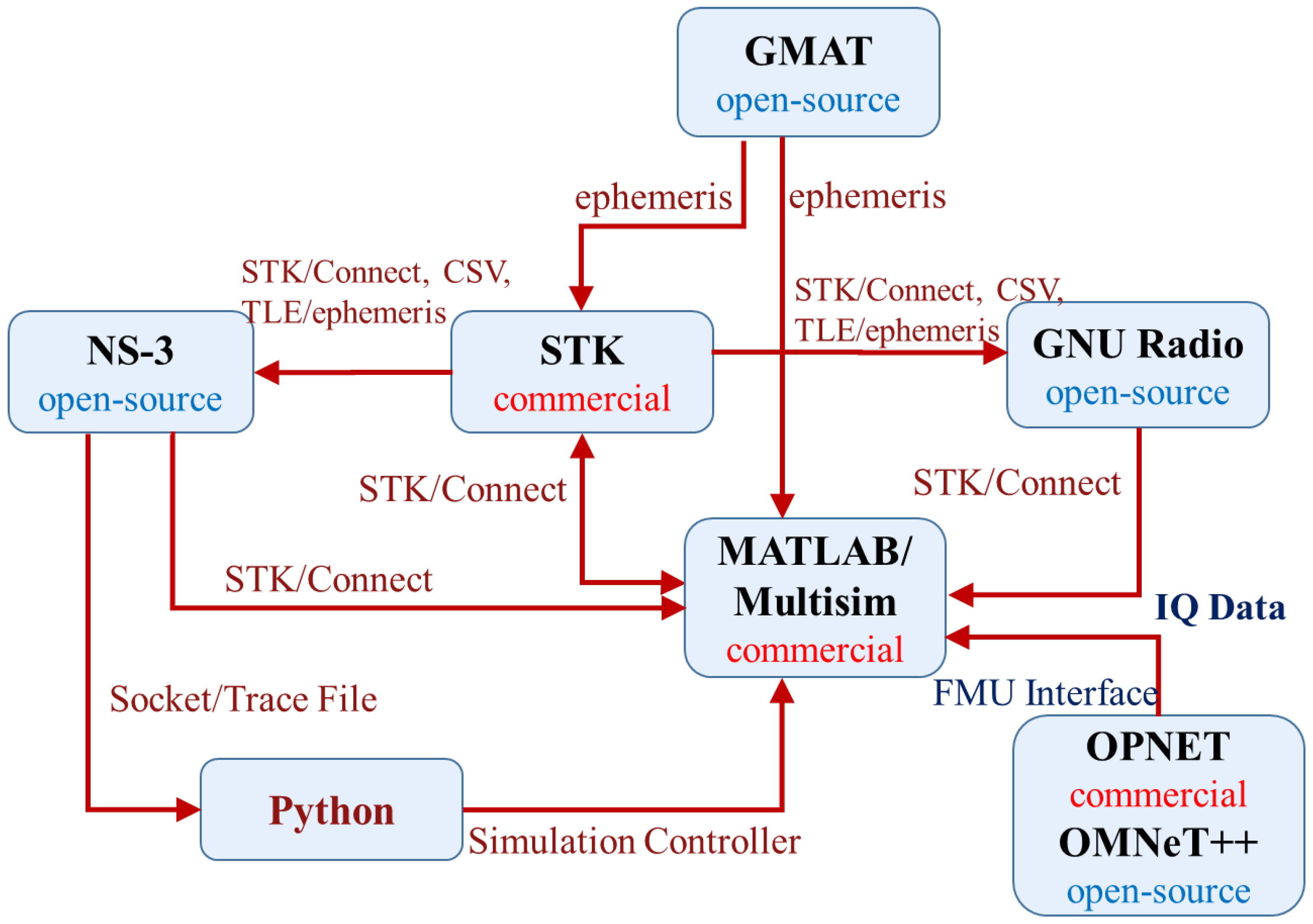
Given the modular strengths and complementary capabilities of existing simulation tools, an effective GEO satellite simulation system necessitates hybrid workflows involving multiple specialized software packages. Integration among these tools is achieved through various co-simulation interfaces, each enabling robust information transfer and interoperability. These interfaces include command-driven APIs such as STK/Connect, standardized model exchange methods like Functional Mock-up Units (FMUs), real-time communication channels using network protocols such as Transmission Control Protocol/User Datagram Protocol (TCP/UDP) sockets, and structured file-based data exchanges (e.g., Comma-Separated Values (CSV), JavaScript Object Notation (JSON), ephemeris files).
For example, STK can export precise ephemeris and satellite visibility data in standard formats to MATLAB, which subsequently utilizes this information for detailed physical-layer analyses, such as evaluating SNR, bit error rates (BERs), and link budgets. The resultant performance metrics generated by MATLAB can then be seamlessly transferred through TCP/UDP sockets or structured files (e.g., JSON) to network simulators such as NS-3 and OMNeT++, enabling comprehensive end-to-end performance assessment.
As illustrated in
Figure 2, the co-simulation framework clarifies how each interface type functions within the hybrid environment. Specifically, it delineates the precise direction of information flow, identifies which data formats are involved at each step, and highlights the roles each tool assumes within the integrated workflow. Such detailed visualization and explanation of interface mechanisms not only promote clarity but also underscore their practical significance in achieving accurate and reliable GEO satellite simulation systems. These interfaces collectively ensure consistent data synchronization, model fidelity, and ultimately facilitate the scalability and flexibility required for complex mission planning scenarios.
4.6. Summary and Implications
This comprehensive analysis underscores that no single existing simulation platform provides a fully integrated solution spanning all functional modules required for GEO satellite communication systems. The strengths and limitations identified across individual tools highlight the necessity of a modular, integrated simulation framework capable of leveraging specialized capabilities across platforms. Although a full-scale simulation-based validation is beyond the scope of this manuscript, the proposed framework builds upon well-established integration practices using widely adopted tool chains (e.g., STK-MATLAB-NS-3), which have been successfully applied in mission planning, system evaluation, and scheduling analysis in both academia and industry. Our structured evaluation (
Section 4.1,
Section 4.2,
Section 4.3,
Section 4.4 and
Section 4.5) confirms the technical feasibility of such cross-platform interoperability, while the system requirements and scenarios detailed in
Section 2 and
Section 3 demonstrate the framework’s practical relevance and scalability. These insights collectively motivate the hybrid co-simulation strategy proposed in this study and lay the groundwork for a fully implemented prototype in future work.


