Abstract
This paper analyzes the exploitability, economic viability, and impact of fleet-based 5G network extensions implemented in maritime environments, focusing on the Baltic Sea and Mediterranean as a case study. Through cost–benefit analysis and business model validation, we demonstrate how multi-hop 5G connectivity can reduce communication costs while improving service quality for maritime operators. Our findings indicate that implementing vessel-based 5G relay stations can achieve 80–90% coverage in key maritime corridors with a break-even period of 2–3 years. The study reveals that combining vessel-to-vessel relaying with strategic floating base stations can reduce connectivity costs by up to 40% compared to traditional satellite solutions, while enabling new revenue streams through premium services. We provide a detailed economic framework for evaluating similar implementations across different maritime routes and suggest policy recommendations for facilitating cross-border 5G maritime networks and introduce key use cases value creation for network extension.
1. Introduction
The maritime industry’s digital transformation is increasingly dependent on reliable, high-speed connectivity. While 5G technology promises to revolutionize maritime communications, its implementation in marine environments presents unique economic challenges and opportunities. Traditional satellite-based solutions, while providing wide coverage, often involve prohibitive costs and higher latency rates that limit their effectiveness for modern maritime applications.
Recent technological advances in multi-hop 5G connectivity present an opportunity to revolutionize maritime communications while potentially reducing operational costs. However, the economic viability of such implementations, particularly in cross-border scenarios, remains understudied. This research addresses this gap by providing a comprehensive analysis of the economic impact of fleet-based 5G network extensions, using the Baltic Sea and Mediterranean as a case study.
In this paper, the authors use results gained from field trials to credibly deliver a validated results-based cost/benefit analysis on the developed technologies and services. The outcome includes a consolidated and verified description of new business opportunities based on the qualitative and quantitative assessments of 5G-ROUTES ecosystems, through stakeholder-based evaluation and validation, and maritime use case analysis based on real ship movement data analysis. For data modeling and economic value analysis, we use data modeling based on an Automatic Identification System (AIS) and logistics/travel data in the Northern Europe (North and Baltic Sea) and South Europe (Mediterranean/Aegean Sea) areas covering around 1.5 billion data points extending 5G coverage for maritime applications through the strategic placement of floating base stations.
2. Background
2.1. Current State of Maritime Connectivity
Maritime connectivity solutions have traditionally relied on a combination of terrestrial networks near coastlines and satellite communications for open-sea operations. However, these solutions often struggle to meet the increasing bandwidth demands of modern maritime operations while remaining cost-effective. Previous studies have highlighted the limitations of existing solutions, particularly in terms of cost-efficiency and performance in high-traffic maritime corridors.
The current most common solutions on the market today are described below and illustrated in Table 1.

Table 1.
Comparison of maritime connectivity technologies [1,2,3,4].
Using the integration of multiple communication technologies is an opportunity to provide seamless and optimized connectivity. These may include terrestrial networks, high-mast links, geostationary satellites, LEO satellites, and cellular networks. However, for implementation, there is a need for devices that can manage and switch between various communication links, e.g., Software-Defined Networking (SDN) [5] allows dynamic network management and optimization based on predefined policies and distributes traffic across multiple links and provides redundancy in case of link failure. SDN also determines the most efficient communication path based on factors such as cost, bandwidth, latency, and reliability [6]. This has been implemented in the maritime sector by various shipping entities such as Stena Lines with support from key provider Nowhere Networks [7].
2.2. Economic Implications of Maritime Connectivity
The maritime sector has characteristics that make it unique compared to other economic sectors, e.g., interdisciplinarity, public and international interests and governance, limited sea resources, large investments and long implementation period, global dimensions, etc. Due to these specificities, the effects of the maritime sector’s development are beyond the sector’s boundaries. This makes the scope of economic impact more extensive. Based on the maritime cluster concept, sectoral linkages play an important role in increasing regional economic impact, including growth and competitiveness. Every new development, including improved connectivity in the sector, brings new opportunities for the entire sector. Maritime cluster contains the following [8]:
- Traditional areas—shipping, ports, and maritime industry (shipbuilding and ship repair and marine equipment industry).
- Maritime-related services—maritime logistics, transport services, classification institutions, finance and insurance, etc.
- Related and supportive sectors—fishing and aquaculture, maritime tourism and recreation, offshore technology (incl. marine energy), public sector (authorities, education and science institutions), etc.
In previous studies, few focus primarily on the economic impact of maritime connectivity related to 5G. However, when considering 5G connectivity as part of the overall maritime connectivity, there are literature results that can be extended. Porelli et al. [9] studied how to enhance seaport competitiveness through 5G-enabled applications and services. Since competitiveness is considered one of the main factors leading to economic success of seaports [10], the results of Porelli et al. show that the support of 5G installations in improving competitiveness. Saeed et al. [11] explored the relationships among maritime connectivity, trade, and economic growth. According to their study, local and international policies should focus more and foster maritime connectivity as an important economic aspect. Li et al. [12] investigated the impact of port connectivity on regional economic growth based on the experiment of Panama Canal expansion. The findings revealed that the developments of port connectivity have positive effects on regional economic growth. Bekteshi et al. [13] analyzed the impact of shipping connectivity on environmental quality, financial development, and economic growth, and the results confirmed that increased maritime connectivity has positive outcomes for the economy. Among other issues, the EU project 5G-ROUTES investigates, among other things, business validation of the 5G-routes ecosystems, including economic influences; the results particularly highlight the benefits for maritime logistics from improving 5G connectivity at sea [14]. These and several other studies [8] focuses on the role of local and international policies in ensuring the success of maritime connectivity. In addition, the creation of 5G connectivity at sea will also contribute to achieving the United Nations’ Sustainable Development Goals (goal 8—decent work and economic growth) [15].
Research has shown that improved maritime connectivity can significantly impact operational efficiency and create new revenue opportunities [16,17]. Studies indicate that reliable, high-speed connectivity can reduce operational costs through improved fleet management, reduced fuel consumption, and optimized route planning. Additionally, enhanced connectivity enables new services and revenue streams, particularly in passenger transportation.
2.3. Regulatory Framework and Standardization Considerations
The deployment of maritime 5G network extensions demands a clear regulatory framework and effective standardization to ensure interoperability, operational reliability, and seamless cross-border connectivity. Key identified regulatory aspects include spectrum allocation and cross-border frequency coordination. The spectrum harmonization, especially for maritime applications, involves coordinated international agreements under ITU guidelines, aiming to mitigate interference and promote seamless connectivity. For example, certain frequency bands require multilateral coordination in border areas, with distinct technical conditions applied based on proximity and geographical features to prevent harmful interference. These agreements outline emission limits, power density parameters, and necessary cross-border coordination processes.
Moreover, maritime regulatory compliance presents additional complexities due to GDPR considerations and specific maritime spectrum licensing procedures, which vary across jurisdictions. Thus, regulatory and standardization advancements remain imperative for enabling scalable maritime 5G deployments.
The maritime trials have further emphasized the need for frameworks for coordination of comprehensive remote interference, critical for operational reliability and spectrum management in maritime cross-border scenarios. It is essential to address these regulatory and standardization issues for realizing the full economic and operational potential of maritime 5G networks.
2.4. Usecases of Maritime Connectivity
Overall, the adoption of advanced communication technologies in the maritime sector has the potential to enhance operational efficiency, safety, and environmental monitoring. Key areas that could benefit from improved connectivity include the following [18]:
- Transport and logistics optimization;
- Fleet and infrastructure management;
- Passenger transport and consumer data services;
- Search and rescue operations (SAR);
- Environmental monitoring;
- Port operations and security;
- Offshore fleet teleoperations;
- Fishing;
- Digital twins of fleets, shipping routes, and maritime logistics;
- Defense and military security.
2.4.1. Passenger Transport—Real-Time Collaboration
Passenger demand for premium travel experiences is reshaping the market, with global virtual collaboration projected to grow from USD 11.56 billion in 2020 to USD 57.23 billion by 2026. Maritime opportunities are particularly strong, as ferries enable immersive VR meetings and collaboration across borders, meeting growing expectations for advanced in-transit services. Challenges persist, including the need for seamless 5G handovers between networks, particularly in coastal and open-sea areas. Established players like Microsoft and Meta lead the virtual collaboration market, requiring new solutions to differentiate through mobility-specific applications and integration with infotainment and logistics services. Regulatory complexities, such as GDPR compliance and maritime spectrum allocation, add further obstacles, while ensuring low latency performance remains critical to delivering high-quality user experiences [18].
2.4.2. Transport Logistics and Goods Tracking
The growing demand for transparent and efficient logistics systems has led to significant investment in real-time goods tracking solutions, particularly those leveraging 5G technology. The Via Baltica-North Corridor, with its strategic position in EU logistics networks, stands to benefit greatly from 5G-enabled solutions that provide end-to-end visibility for goods moving across multiple modes of transport. The introduction of the EU’s eFTI regulation (i.e., digitalizing freight transport across the EU), which mandates the digitization of freight transport information starting in 2027, presents a significant opportunity for the 5G-ROUTES project, since it boosts the digitalization of logistics cluster and makes enables digital data exchange [19]. Together with other digitalization regulations, connectivity and data amounts will increase significantly in the near future. Such regulations will drive the demand for digital platforms that can provide real-time tracking, ensure regulatory compliance, and enhance operational efficiency. However, gaps in 5G coverage, particularly in remote areas, could limit the effectiveness of these platforms in providing seamless tracking across the entire logistics chain. Using vessels as moving base station platforms provides opportunities for extending the coverage of 5G networks [18]. The efficiency of network provision relies on repeating patterns within the ships’ movements, which is related to the type and cargo of the vessel. Research [20] has shown that tankers, cargo ships, and cruise liners provide ample coverage [21,22].
2.4.3. Fishing and Environmental Monitoring
Fifth-generation access for fishing boats can significantly enhance operations and safety while at sea. With high-speed and low latency connectivity, fishing vessels can utilize real-time navigation tools, weather updates, and oceanographic data to optimize their routes and fishing locations. This minimizes fuel consumption and maximizes efficiency by targeting areas with higher fish stocks. Furthermore, 5G enables seamless communication with onshore teams, ensuring that vessels can quickly report emergencies or technical issues, thereby improving crew safety. It also opens possibilities for real-time video streaming from fishing operations, which can enhance transparency and traceability in the seafood supply chain, fostering consumer trust and regulatory compliance. Ultimately, 5G connectivity empowers fishing boats to become smarter and more efficient, benefiting both the industry and the environment [23].
The second major benefit is the ability to deploy advanced Internet of Things (IoT) devices across fish farms at sea. These devices, such as underwater sensors and cameras, can monitor water quality parameters like temperature, salinity, pH levels, and oxygen concentration in real-time. With 5G’s ultra-fast data transfer speeds and low latency, this information can be transmitted instantly to operators, allowing them to make timely and informed decisions to ensure optimal conditions for fish health and growth. This not only reduces losses due to unfavorable conditions but also improves overall yield. With future developments in 6G, these opportunities grow even more [24,25].
Moreover, 5G connectivity enables the use of autonomous vehicles and drones for routine inspections and feeding operations in offshore aquaculture farms. These vehicles can be programmed to patrol designated areas, identify equipment issues, or dispense feed more efficiently than manual methods. With the enhanced reliability of 5G networks, operators can remotely control these systems from onshore facilities, drastically reducing labor costs and safety risks associated with deploying personnel at sea. Additionally, 5G supports high-quality video streaming, which can be used for the remote observation of fish behavior and health, allowing experts to identify and address diseases or stress in real-time.
On a broader scale, the integration of 5G technology can help facilitate data-driven approaches to sustainable aquaculture practices. By aggregating data from multiple farms, predictive models powered by artificial intelligence can provide insights into regional environmental trends and potential risks, such as harmful algal blooms or temperature fluctuations. These insights can inform proactive measures to protect marine ecosystems and promote sustainable growth. Ultimately, 5G connectivity has the power to transform aquaculture into a more advanced, efficient, and environmentally responsible industry, paving the way for a more secure and sustainable seafood supply [23].
2.4.4. Defense and Security
With private 5G, and main technology enablers, including Spectrum, 5G New Radio, 5G Core Network, Proximity Services, and Non-Terrestrial Networks (NTNs), military forces can deploy advanced systems like the Internet of Battlefield Things (IoBT), where interconnected devices, sensors, and autonomous systems work seamlessly to provide situational awareness. This enables commanders to access and analyze vast amounts of data in real-time, improving coordination and response times during missions [26] while preserving the security of the data and processing [27,28].
Another significant application of 5G in the military is its role in supporting autonomous vehicles and drones. These systems rely on high-speed connectivity to perform tasks such as surveillance, reconnaissance, and even combat operations. Fifth-generation networks allow these vehicles to operate with greater precision and reliability, reducing the need for human intervention in dangerous environments. Additionally, the technology facilitates the use of augmented reality (AR) and virtual reality (VR) tools for training and mission planning, providing soldiers with immersive and realistic simulations to prepare for complex scenarios.
Furthermore, 5G enhances cybersecurity and network resilience in military operations. Its advanced network architecture, including features like network slicing, allows for the creation of secure and dedicated communication channels for specific missions. This ensures that critical information remains protected from potential cyber threats. Overall, 5G technology represents a transformative leap forward for military applications, offering unparalleled capabilities to modernize and strengthen defense system [27,29,30].
2.5. Technical Framework of 5G Multi-Hop
Maritime communication is crucial due to the dramatic increase in oceanic activities, including naval shipping and logistics, offshore oil exploration, wind farming, fishing, and tourism. Thus, it is imperative to provide seamless coverage using ship-to-ship connections [31]. The main challenge in providing 5G connectivity on the sea is to provide coverage over large areas of open water. There has been a gap identified in the literature [32] regarding aspects related to the deployment, testing, and trialing of actual mobile networks endowed with a satellite component and multi-hop technology in maritime environments, which is one of the main goals of the 5G-ROUTES project. The same article included a measurement campaign conducted to assess the current coverage in the Baltic Sea, concluding that the current terrestrial networks cannot guarantee sufficient coverage [33].
One of the reasons the IAB was proposed by the 3GPP was to reduce the expenses related to deploying fiber optics for 5G and beyond networks [34]. However, one of the most relevant works about fixed and moving multi-hop relaying (Figure 1) for reducing infrastructure deployment costs and enhancing cellular network capacity was already proposed in 2004 [35]. Throughout the years, different releases have been created by 3GPP, so several publications have described and expanded the IAB concept in different fields and intend to optimize it in both dense and suburban deployment areas from various points of view. Different surveys have introduced and discussed IAB as a technique to augment the 5G technology in 3GPP releases 16 and 17 [34,35,36]. Moreover, in 2020, Ericsson [37] presented IAB concepts in a white paper article, explaining the IAB idea at a high level, presenting its architecture and key characteristics, and examining its advantages and disadvantages compared with other backhaul technologies.
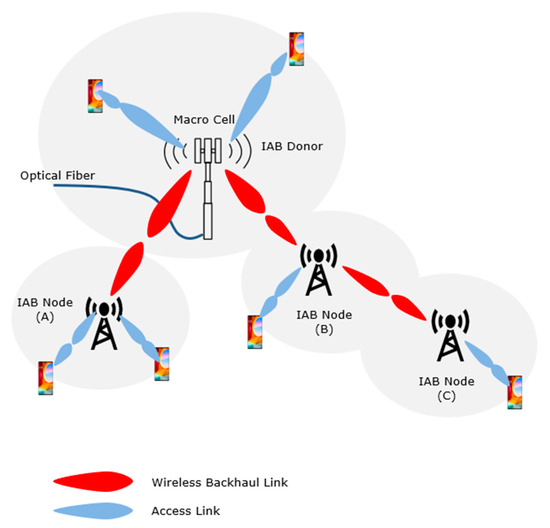
Figure 1.
Multi-hop backhauling.
As an additional option, IAB allows the deployment of mobile cells, known here as mobile IAB (mIAB) cells, which should become available after the release of 18 of 3GPP. The mobile IAB is expected to enhance the service of moving UEs, improve connectivity to the network, and avoid signaling storms from simultaneous handover (HO) messages [38]. As a concept, the main feature of 5G IAB is the capability to utilize a macro cell as a donor to other IAB cell nodes. This system permits UEs connected to the nodes to transfer their traffic to a macro cell via wireless backhaul hops, saving infrastructure costs [39].
Range extension studies in the literature mainly cover the multi-hop backhauling with mmWave frequencies, but in the planned trials, a spectrum below 6 GHz will be used as a primary alternative since higher frequencies in the millimeter domain are expected to have several disadvantages in achieving seamless cross-border connectivity [32]. In this context, the routing strategies are of high importance, but due to the constraints on time and technical resources, simplified routing strategy was used to enforce optimal usage of bandwidth, thus negating the need for additional load balancing [39]. However, the need for development of high-capacity, high-frequency routing algorithms is necessary for future research.
In 3GPP, 5G networks can be categorized as standalone (SA) and non-standalone (NSA). A public 5G network is defined in 3GPP as a Public Land Mobile Network (PLMN) and it is operated by a mobile network operator (MNO). The public network provides public 5G network services within a given typically nation-wide region. The private 5G network is called a Non-Public Network (NPN) in 3GPP. It is intended for the sole use of a private organization, typically an industry vertical. It allows the organization to run a local network with dedicated equipment and configurations, which makes the management and forecasting of the network performance and load easier. Compelling features of a private 5G network include the following [40,41]:
- Dedicated coverage: Private 5G networks offer exclusive coverage at a facility or location where public networks do not exist or where indoor coverage is not robust.
- Exclusive capacity: A private 5G network has absolute use of the available capacity. There is no contention from other network users.
- Enhanced security and privacy: Fifth-generation networks can be used to protect data privacy or resolve security concerns by restricting unauthorized users.
- Intrinsic control: A private 5G network offers its owner the possibility for complete control and deployment of their own security policies to authorize users, prioritize traffic, and ensure that sensitive data do not leave the premises.
- Customized services: A private 5G network can be customized as per requirements of specific industrial applications. A private 5G network can be efficiently shared among multiple industrial applications and verticals.
Despite the benefits mentioned above, making the private network entirely independent of public networks is not always an optimal solution. The sole private network is likely to cause higher Capital Expenditure (CAPEX) investments and increased Operating Expenditure (OPEX) costs to acquire the necessary expertise to manage a 5G core network. Moreover, there may frequently be a need to have connectivity to devices also when they are outside the coverage area of the private network or require access to local and regional data networks. The former refers typically to an edge node with Multi-access Edge Computing (MEC) capabilities to run certain service applications in industrial premises. The latter refers to one or more cloud data centers typically hosted by an MNO to offer public data services. Due to these reasons, integrating NPN into PLMN may be desirable to enable device connectivity in out-of-coverage NPN scenarios and reduce entry barriers to suppliers.
Consequently, 3GPP defines two major categories of NPNs: Standalone Non-Public Network (SNPN) and Public Network Integrated Non-Public Network (PNI-NPN). The latter contains three options described shortly [35,37].
- Customized services: A private 5G network can be customized as per the requirements of specific industrial applications. A private 5G network can be efficiently shared among multiple industrial applications and verticals.
- Standalone: All network functions are located inside defined premises and the network is separate from the public network. The only communication path between the NPN and the public network is via a firewall and roaming agreements. The network is assigned a private spectrum from an MNO or from a regulator and contains full deployment of a 5G system.
- Shared RAN: A part of the RAN is shared among the owner and the MNO. All other network functions are segregated, as in the case of SNPN. The NPN data reside within the defined premises of the organization.
- Shared RAN and control plane: Not only is the RAN shared but the network control tasks are also performed by the PLMN. RAN excepts that the radio carriers are shared between two or more operators. The NPN data reside within the premises of the owner. This scenario can be implemented using Access Point Name (APN) or network slicing.
- Hosted by public network: The private network is hosted by an MNO. Only gNBs are deployed at the owner’s premises and all other communication network functions are provided by the MNO. End-to-end network slicing is used for segregating the private and public networks to be logically independent of one another.
Recent Maritime Trials
The maritime multi-hop pilot was initiated by LMT, focusing on architecture design and supportive field tests. In September 2023, VTT in collaboration with Finnish partners continued this activity. VTT developed a testbed, addressing the following challenges:
- Non-Public Network—Public Network (NPN-PN) interaction with the floating private 5G networks.
- Non-Terrestrial Network (NTN) connectivity with link management.
- Multi-hop functionality between private networks on vessels by mimicking Mobile Integrated Access and Backhaul (mIAB) features.
The testbed utilized two private and two public 5G networks complemented by a OneWeb satellite connection to support cross-border scenarios. Since mIAB (Mobile Integrated Access and Backhaul), PN-NPN (Public Network–Non-Public Network), and TN-NTN (Terrestrial Network–Non-Terrestrial Network) features are not yet commercially available, the team implemented an overlay functionality that mimics these NR functions.
The multi-hop maritime trials supported two configurations illustrated in Figure 2 and Figure 3. Configuration A represents a scenario wherein a larger vessel equipped with both OneWeb satellite and 5G connectivity serves as a data traffic relay for a smaller vessel to delegate traffic to the onshore public 5G NSA network. A link management functionality integrated in the 5G router dynamically selects a satellite or 5G communication link based on prevailing radio channel conditions and traffic load. The communication route, depicted by dotted green and blue lines, is determined to optimize performance.
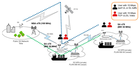
Figure 2.
Maritime setup configuration A.
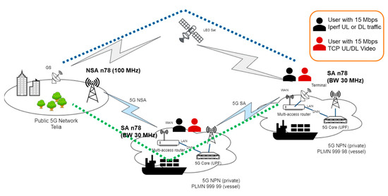
Figure 3.
Maritime setup configuration B.
Configuration A poses a potential bottleneck with the 5G connection between the vessels. The smaller vessel is reliant on the connection to vessel A. If the connection is lost or very weak, the smaller vessel is unable to send traffic. Moreover, the satellite link from the larger vessel bears the burden of additional traffic from the smaller vessel.
In configuration B, the smaller vessel acts as a relay for a larger vessel to the onshore network. Essentially, the smaller vessel extends the 5G service coverage of the larger vessel. The multi-hop 5G connection of the larger vessel is prioritized over the satellite connection. Due to the placement of the smaller vessel, its traffic does not impose any supplementary load on the satellite connection. Furthermore, in the event of a 5G connection loss between the vessels, the data transmission from the larger vessel remains uninterrupted. It can switch to the satellite connection as a backup, as illustrated in Figure 3 with a blue dotted line.
The work started with simulations with an open-source UERANSIM environment to test multi-hop routing and 5GC configurations of two private 5G SA cores. In February 2024, the pilot implementation progressed with the utilization of real RANs and UEs. Two private 5G SA n78 networks were installed in VTT lab premises and connections to a public 5G NSA n78 and SA n28 networks (to mimic the satellite network) were established with successful completion of in-lab tests. The target architecture design for the trials is shown in Figure 4.
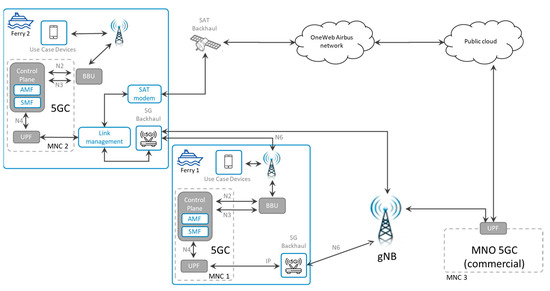
Figure 4.
Architecture design for lab trials.
In-lab test experiments were conducted using bandwidth options of 40 MHz, 60 MHz, and 100 MHz. After the completion of in-lab tests, the testbed performance was tested outdoors in the campus area of Otaniemi, near VTT facilities, by installing the private networks and antennas in two vans.
These trials demonstrated the success of deploying a mobile 5G multi-hop testbed in a maritime environment with the existing 5G technology (TRL 6–7), where 5G coverage and capacity were extended by around 9 km without exploiting special network configurations, increasing transmission powers, or using extreme antenna heights. The mIAB, PN-NPN, and TN-NTN features are not yet commercially available, so we implemented an overlay functionality that mimics these NR functions. Due to the absence of mIAB interfaces, the traffic traverses through multiple RANs and 5GCs, increasing RTT by 10–13 ms per hop. The lack of PN-NPN and TN-NTN integration forced us to use a multi-access router for link management, which is needed to select the optimal communication path based on the radio channel conditions and the load situation. It added an extra 30 ms of latency due to the MIP/VPN signaling.
In the maritime environment, the weakest link was the first connection, either to the public 5G network or satellite. The 5G performance depended on the location of the relay vessel and the load in the public 5G network. Moreover, the asymmetric 4:1 Time-Division Duplexing (TDD) frame structure made the UL direction restrictive, requiring more bandwidth to be allocated to the private networks.
The network planning in maritime areas is more coverage- than capacity-oriented. In addition, a high number of handovers and stronger multipath effects were detected. The UEs on the vessel move with the gNB, so the connection remains good and the high order modulations, e.g., QAM-256, can be used in the UL and DL directions. The handover to a target cell via a gateway is carried out instantly for all UEs on the vessel, which reduces signaling on the UE and the network side. The 5G multi-hop solution reduces the number of HOs and lowers the interference, making performance more stable and predictable.
Performance in the UL direction was restricted by three factors. The performance of the first link, the public network link or the satellite link, affects the performance of the whole system. The public network is mainly designed for coverage of the coast and not of the sea, and movement can cause multiple handovers, and passing liners can cause high peaks. The third reason is a limited satellite connection. This issue can be solved with a better Service Level Agreement (SLA), but increased delay and jitter can still be a challenge to applications that cannot tolerate long delays or high jitters. A third factor is the relative location of the two vehicles with respect to each other. In the trials, a sector antenna on board was used, mainly for safety reasons and to avoid interference with other 5G networks, and as such, performance decreases when the second vessel is not in the main beam of the sector antenna.
A multi-access router enabled PN-NPN and TN-NTN interactions. The link switch next to the border cannot be QoS-based because RF signals cannot detect country borders. Switching must be based in a location that is straightforward to implement on commercial liners or roll-on/roll-off (RoRo) vessels that periodically operate between the same international ports. The multi-access router allowed seamless switching between different public operators, but the management of the increased load and efficient use of bandwidth should be orchestrated among the mobile operators.
3. Methodology
Our study employs a comprehensive approach (Figure 5) that integrates spatial analysis, economic assessment, and business validation methodologies to evaluate the feasibility of 5G maritime networks across different European maritime regions. This multi-faceted methodology enables a thorough examination of both technical and economic aspects of maritime 5G implementation while accounting for regional variations. We employed a hexagonal grid analysis methodology with 1 km side lengths to model network coverage requirements effectively. The hexagonal grid approach was chosen as the best approximation of signal propagation without overlapping between the cells while preserving the omnidirectional capacity of transmissions. This granular approach allows for the precise assessment of coverage needs while maintaining computational efficiency [42]. The length of one kilometer was chosen as the optimal cell size, allowing more detail than using maximum coverage as the cell size, which is especially important in narrow straits. Ship track analysis was conducted using PostGIS 3.0, enabling detailed examination of spatiotemporal patterns and vessel movements across different maritime regions. Two different datasets were employed for the analysis, one covering Danish Straits [43] and other on Aegean Sea [44]. The data were preprocessed by the providers; thus, no raw AIS message decoding was necessary. The processed data were stored in a PostGIS database, leveraging its powerful spatial analysis capabilities.
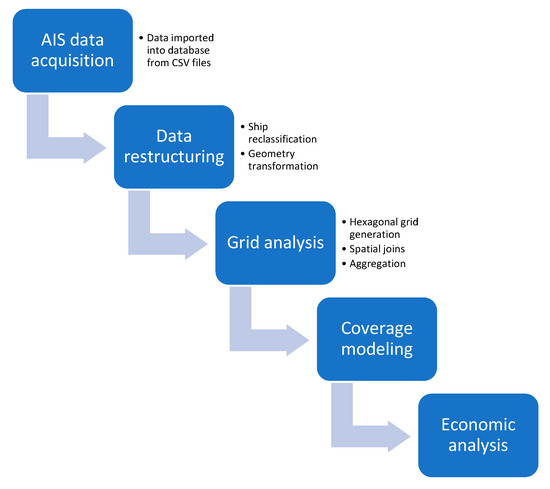
Figure 5.
Data analysis workflow.
The source data were integrated into a single PostgreSQL data table with the following parameters for each data point:
- Unique identifier;
- MMSI (Maritime Mobile Service Identity) code;
- UTC Timestamp;
- Speed Over Ground;
- Course Over Ground;
- Vessel category;
- EPSG:3857 geometry.
The classification of ships into broader categories was conducted to simplify the analysis while maintaining meaningful distinctions between vessel types. This classification scheme was developed based on the primary function and operational characteristics of the vessels. Cargo ships, including those carrying hazardous materials, were grouped under the ‘Cargo’ category due to their similar operational profiles and roles in freight transport. Fishing vessels were kept as a distinct category given their unique patterns of movement and areas of operation. Passenger vessels, including high-speed crafts, were consolidated into the ‘Passenger’ category, reflecting their common purpose of transporting people. Pleasure crafts, sailing vessels, and similar recreational boats were grouped under ‘Pleasure’ to represent non-commercial maritime activities. Search and Rescue (SAR) vessels were maintained as a separate category due to their specialized function. Various service vessels, including tugs, pilot vessels, and those engaged in specialized operations like dredging or law enforcement, were categorized as ‘Service’ vessels, reflecting their supporting roles in maritime operations. Tankers were kept as a distinct category due to their specific design and cargo type. Vessels that did not clearly fit into these primary categories or had ambiguous classifications were grouped under ‘Other’.
As a next step, ship trajectories were calculated based on timestamps and existing coordinates. Ship tracks were represented as geometric objects in the PostGIS data table. Timestamps were stored as Z coordinates, enabling efficient spatiotemporal analysis [18]. This representation allows for queries that can identify spatiotemporal overlaps between different ship tracks. Due to extensive temporal coverage, seasonality factors were not considered. Each hexagonal cell was spatially joined by ship tracks, providing an overview of vessel traffic in that specific region (Figure 6).
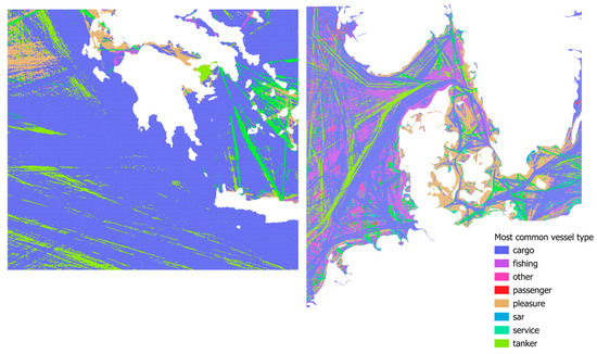
Figure 6.
Spatial coverage of analyzed area with most common vessel type per cell.
To analyze the spatial relationships between different ship types, we conducted a correlation analysis using the ship count data across all cells in our study area. We utilized the Pearson correlation coefficient to measure the linear relationship between each pair of ship types. For each location, we considered the count of ships for each type as variables. The correlation coefficient was calculated for every possible pair of ship types, resulting in a correlation matrix.
For the coverage optimization, we reused an algorithmic approach with different objective functions. The general concept has the base stations added in batches until full coverage was reached. The process scheme is shown on Figure 7.
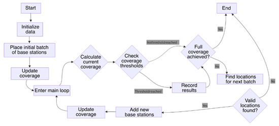
Figure 7.
Base station coverage algorithm overview [18].
The coverage of maritime vessels by base stations within the hexagonal grid system is quantified by the following:
where
Coverageships(i,j)—Proportion of ships covered by base stations in cell (i,j).
Stotal(i,j)—Total number of ships present in cell (i,j).
Cov(i,j)—Binary indicator (1 or 0) denoting whether cell (i,j) has coverage.
Coverage of the maritime area by base stations within the hexagonal grid is calculated as follows:
where
Coveragearea(i,j)—Proportion of total area covered by base stations in cell (i).
Ah—Area of individual hexagonal cell (approximately 2.6 km2).
Cov(i,j)—Binary indicator (1 or 0) denoting whether cell (i,j) is covered.
The potential coverage of a cell based on placing a base station within that cell is represented by the following:
where
PC(i,j)—Potential coverage achievable if a base station is placed in cell (i,j).
Stotal(a,b)—Total number of ships within neighboring cells (a,b) potentially covered by placing base station in cell (i,j).
Cov(a,b)—Binary indicator (1 or 0) for neighboring cells (a,b) indicating their existing coverage status.
To assess the economic feasibility of dual-use applications, we developed a comparative cost–benefit framework analyzing the potential for 5G infrastructure to support emergency services and maritime safety operations. This methodology incorporated SAR (Search and Rescue) data from the hexagonal grid analysis to identify optimal drone deployment patterns based on historical emergency response requirements. The framework established operational cost benchmarks for traditional helicopter-based maritime operations, including acquisition, maintenance, personnel, and operational expenses, and contrasted these with estimated costs for 5G-enabled drone alternatives. Break-even analysis was performed for both regions, calculating infrastructure investment recovery periods under both dedicated and shared cost scenarios. The methodology factored in region-specific coverage requirements derived from the base station optimization analysis, accounting for the distinct geographical characteristics and emergency response patterns in the Danish Straits and Aegean Sea. This approach enabled the quantification of potential operational efficiencies, including response time improvements, coverage expansion, and operational hour increases, while identifying the infrastructure density requirements necessary to support reliable drone operations in maritime environments.
The base station allocation problem can be formulated as an optimization challenge where the objective is to minimize the number of base stations while ensuring adequate coverage of maritime traffic. We model the geographical area using a hexagonal grid system, where each cell represents approximately 2.6 km2 of maritime space. For a maritime region represented by hexagonal cells, each cell contains information about vessel traffic categorized by type (cargo, fishing, passenger, etc.), distance to land, and other relevant attributes. The primary decision variables are binary indicators representing the placement of base stations in specific cells.
4. Results
4.1. Comparison of Study Areas
The maritime traffic patterns in the Danish Straits and Aegean Sea present distinct characteristics that significantly influence 5G network implementation strategies. An analysis of the extensive hexagonal grid data covering 382,543 cells in the Danish Straits and 206,267 cells in the Aegean Sea reveals fundamental differences in vessel distribution, movement patterns, and spatial coverage (Figure 8).
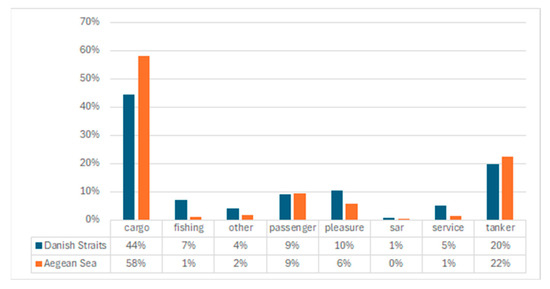
Figure 8.
Ship type distribution between different areas.
In the Danish Straits, vessel traffic demonstrates a pronounced concentration of cargo and tanker vessels, which together constitute approximately 64% of total maritime traffic. This pattern reflects the region’s critical role as a strategic shipping lane connecting the Baltic Sea with global maritime routes. Correlation analysis reveals an exceptionally strong relationship (r = 0.87) between cargo and tanker movements, indicating highly aligned traffic patterns that create predictable corridors of maritime activity (Figure 9). The statistical significance of these patterns is confirmed through both Mann–Whitney U and Kolmogorov–Smirnov tests (p < 0.001), establishing that the observed distributions represent genuine regional characteristics rather than sampling artifacts.
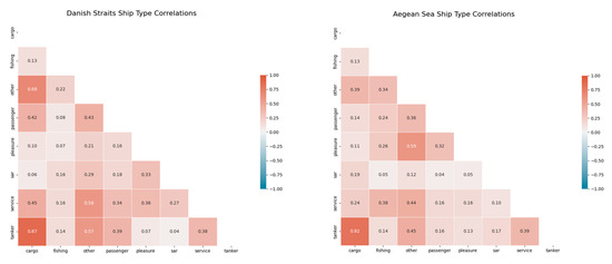
Figure 9.
Spatial correlation of ship type in different regions.
The Aegean Sea presents a markedly different maritime environment, with cargo vessels dominating at 58.1% of total traffic, followed by tankers at 22.3%. This region shows notably lower proportions of fishing vessels (1.2% compared to 7.2% in Danish Straits) and pleasure crafts (5.6% compared to 10.4% in Danish Straits). However, the spatial analysis reveals a critical distinction: despite lower proportional representation, the Aegean Sea demonstrates significantly higher spatial coverage for most vessel types. Cargo vessels are present in 99.0% of Aegean Sea grid cells compared to 80.9% in the Danish Straits, while tankers appear in 97.3% of Aegean cells versus 58.6% in the Danish region. This widespread distribution reflects the complex geography of the Aegean archipelago, where shipping routes navigate through numerous islands, creating a more diffuse traffic pattern compared to the channelized nature of the Danish Straits.
Correlation patterns between vessel types also differ significantly between regions (Figure 10). While both areas show strong cargo–tanker correlations, the Aegean Sea exhibits a distinctive correlation (r = 0.59) between ‘other’ vessels and pleasure crafts, substantially higher than observed in the Danish Straits (r = 0.21). This pattern likely reflects the region’s tourism-oriented maritime activities, with pleasure crafts following routes similar to small commercial vessels servicing island communities. Conversely, the Danish Straits show stronger correlations between service vessels and other maritime traffic (r = 0.58 with ‘other’ vessels and r = 0.45 with cargo), suggesting more integrated support operations along major shipping lanes.
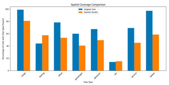
Figure 10.
Spatial coverage of ship types per region.
The implementation of maritime 5G networks must account for these regional differences. In the Danish Straits, the high concentration of cargo and tanker traffic along defined corridors presents opportunities for efficient relay-based coverage with minimal infrastructure. The predictable nature of vessel movements supports the strategic placement of multi-hop nodes along major shipping lanes, potentially achieving 80–90% coverage of commercial traffic with targeted deployment. The strong correlation between vessel types indicates that infrastructure serving cargo vessels will inherently support tanker operations, creating natural efficiencies in network design.
The Aegean Sea requires a fundamentally different approach. The widespread distribution of vessels across the region necessitates a more distributed network architecture (Figure 11), potentially combining vessel-based relays with fixed installations on islands. While the higher spatial coverage of cargo and tanker vessels (exceeding 97%) provides excellent potential for vessel-based relay networks, the archipelagic geography introduces line-of-sight challenges not present in the more open Danish Straits. Statistical analysis confirms that these regional differences are highly significant (p < 0.001 across all vessel types), requiring tailored implementation strategies rather than a uniform approach.

Figure 11.
Base station placement priorities in Aegean Sea region. Red indicates highest and blue lowest priority.
These findings have direct implications for 5G maritime network economics. The Danish Straits’ concentrated traffic patterns support cost-efficient corridor-based deployment, potentially achieving break-even periods of 2–3 years through focused infrastructure investment. The Aegean Sea, with its more distributed traffic, may require higher initial investment but offers broader coverage potential, particularly if island-based infrastructure complements vessel relays. Both regions show strong potential for vessel-based 5G network extensions, though with distinct optimization strategies reflecting their unique maritime environments.
4.2. Base Station Deployment Analysis: Danish Straits vs. Aegean Sea
The comparative analysis of base station deployment requirements across the Danish Straits and Aegean Sea regions reveals significant differences in coverage efficiency and infrastructure needs for maritime 5G networks. These differences stem from the distinct geographical characteristics and vessel distribution patterns previously identified in the traffic analysis.
4.2.1. Coverage Efficiency Comparison
The Aegean Sea demonstrates markedly higher infrastructure efficiency for both area and ship coverage compared to the Danish Straits as illustrated on Figure 12. For area coverage, the Aegean region requires only 144 base stations to achieve 50% coverage compared to 474 stations in the Danish Straits, representing a nearly 70% reduction in infrastructure requirements. This efficiency advantage persists across all coverage thresholds, with the Aegean Sea requiring only 606 stations for 99% area coverage compared to 2714 stations in the Danish Straits—a 78% reduction in infrastructure needs.
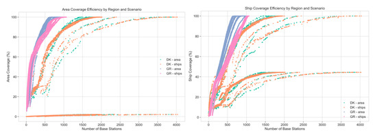
Figure 12.
Coverage scenario efficiencies.
Similar efficiency patterns emerge for ship coverage, where the Aegean Sea requires 390 stations for 50% coverage versus 456 stations in the Danish Straits. The disparity becomes more pronounced at higher coverage thresholds, with 99% ship coverage requiring 1007 stations in the Aegean compared to 1660 stations in the Danish Straits. This indicates that the archipelagic geography of the Aegean, despite its complexity, actually facilitates more efficient network coverage compared to the more open Danish waters.
4.2.2. Optimization Strategy Comparison
The analysis reveals important differences in the effectiveness of area-based versus ship-based optimization strategies across regions as shown on Figure 13. In the Danish Straits, ship-based optimization yields significantly better efficiency for achieving high coverage levels. For 90% ship coverage, ship-optimized deployment requires 1135 stations compared to 1419 stations with area optimization—a 20% reduction. This advantage reflects the channelized nature of maritime traffic in the Danish Straits, where vessel movements follow predictable corridors.
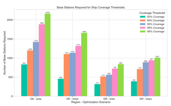
Figure 13.
Optimization strategy threshold limits.
Conversely, the Aegean Sea shows less pronounced differences between optimization strategies. The ship-optimized approach requires 888 stations for 90% coverage compared to 562 stations needed in the area-optimized scenarios to reach 90% area coverage. This suggests that in the Aegean’s complex archipelagic environment, the correlation between geographical coverage and ship coverage is stronger than in the Danish Straits, likely due to the more distributed vessel traffic patterns navigating between numerous islands.
4.2.3. Analysis of Diminishing Returns
The diminishing returns curves reveal critical threshold points where additional infrastructure investment yields minimal coverage benefits, which is shown on Figure 14. In the Danish Straits, a pronounced diminishing returns threshold appears at approximately 1200 stations for ship-optimized deployment, where marginal coverage gains drop significantly. Beyond this point, achieving the final 10% of coverage requires an additional 460 stations, representing nearly 40% more infrastructure for limited additional benefit.
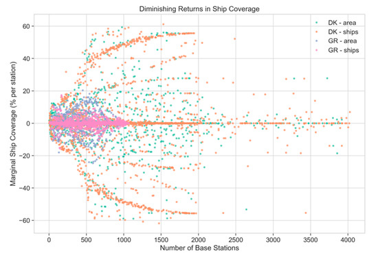
Figure 14.
Diminishing returns of each additional base station.
The Aegean Sea demonstrates a more gradual diminishing pattern, with the inflection point occurring at approximately 700 stations. This region maintains relatively consistent marginal benefits until approximately 90% coverage, after which additional stations yield progressively smaller returns. This pattern suggests that network deployments in the Aegean can be more effectively scaled, with consistent benefit realization until reaching very high coverage thresholds.
4.2.4. Implementation Implications
These findings have significant implications for maritime 5G implementation strategies across different regions. For the Danish Straits, the optimal approach involves ship-optimized placement targeting major shipping lanes, with strategic deployment focused on the 80–90% coverage threshold (requiring 1102–1135 stations) to maximize cost-efficiency. The sharp diminishing returns above this threshold suggest that complete coverage may not be economically justifiable, and hybrid approaches incorporating satellite connectivity for the final coverage increment may be more appropriate.
In the Aegean Sea, the higher overall efficiency and more gradual diminishing returns curve suggest that higher coverage targets are economically viable. Area-optimized deployment proves surprisingly effective for ship coverage in this region, suggesting that geographic distribution should be a primary consideration in network planning. The optimal deployment would target 90–95% coverage (requiring 562–722 stations for area coverage or 888–941 stations for ship coverage), leveraging the archipelagic geography to maximize both area and vessel connectivity.
Both regions demonstrate that ship-based optimization generally yields better coverage efficiency than area-based approaches, confirming that network planning should primarily follow maritime traffic patterns rather than simple geographic distribution. However, the relative advantage of this approach varies significantly between regions, highlighting the importance of region-specific implementation strategies for maritime 5G networks.
4.3. Dual-Use Applications and Economic Feasibility
The potential for dual-use applications substantially enhances the economic feasibility of maritime 5G networks beyond purely commercial considerations. By analyzing Search and Rescue (SAR) data from the hexagonal grid analysis alongside vessel traffic patterns, we can quantify the significant economic advantages of deploying 5G-enabled drone systems as alternatives to traditional helicopter-based operations. Traditional maritime SAR rely heavily on dedicated vessels and helicopter deployments. Based on industry standards, helicopter operations incur significant costs [45].
- Helicopter Operational Costs
- ○
- Average flight hour cost: EUR 3000–8000 for medium-sized SAR helicopters.
- ○
- Annual maintenance: EUR 800,000–1,200,000 per aircraft.
- ○
- Crew training and readiness: EUR 500,000–700,000 annually per operational unit.
- ○
- Base facilities: EUR 1,000,000–2,000,000 annual operating costs.
- Operational Limitations
- ○
- Weather constraints limiting availability (60–70% operational readiness).
- ○
- Response time averaging 45–60 min from alert to on-scene presence.
- ○
- Limited continuous operation time (3–4 h before refueling).
- ○
- Reduced effectiveness in poor visibility conditions.
The SAR data from our regional analysis reveal distinctive patterns in both the Danish Straits and Aegean Sea regions. The Danish Straits show SAR presence in 15.1% of the analyzed cells, with moderate correlation to passenger vessels (r = 0.18) and pleasure crafts (r = 0.33). The Aegean Sea demonstrates similar coverage (14.0%) but weaker correlations with passenger vessels (r = 0.04) and pleasure crafts (r = 0.05), suggesting more dispersed SAR requirements. A 5G network infrastructure enables the deployment of edge computing-equipped drones as force multipliers or alternatives for conventional SAR.
- Drone System Costs
- ○
- High-endurance maritime drones: EUR 80,000–150,000 per unit.
- ○
- Annual maintenance: EUR 15,000–25,000 per drone.
- ○
- Edge computing equipment: EUR 5000–10,000 per unit.
- ○
- Control station equipment: EUR 50,000–100,000 per regional center.
- Operational Advantages
- ○
- Operational readiness exceeding 90% (less weather-dependent).
- ○
- Response time under 15 min to any location within network coverage.
- ○
- Swarm capabilities enabling simultaneous multi-point operations.
- ○
- Continuous operation capability through drone rotation/replacement.
- ○
- Enhanced sensing capabilities through AI-driven edge computing.
- Network Requirements
- ○
- Base station density required for drone operations: One station per 20–25 km2.
- ○
- Additional bandwidth requirements: A total of 100 Mbps per active drone.
- ○
- Edge computing capability at strategic nodes.
- ○
- Redundancy requirements: Minimum 99.9% network availability.
The economic comparison between traditional helicopter-based SAR and 5G-enabled drone alternatives reveals significant potential savings, which are elaborated in Table 2 with cost-effectiveness metrics in Table 3.
Table 2.
Annual operational cost comparison (single operational region).
Table 3.
Cost-effectiveness metrics.
Based on our hexagonal grid analysis, the optimal deployment of 5G infrastructure for drone-based SAR would require the investments described in Table 4.
Table 4.
Regional infrastructure requirements.
However, when considering the shared infrastructure model with commercial maritime uses, the attributable costs to SAR would be significantly reduced, reaching up to 80% in savings. The infrastructure investment for drone-based SAR achieves break-even against traditional helicopter operations in remarkably short timeframes.
- Danish Straits Region
- ○
- Break-even period without cost sharing: 7.5 years.
- ○
- Break-even period with commercial cost sharing: 1.9 years.
- Aegean Sea Region
- ○
- Break-even period without cost sharing: 5.6 years.
- ○
- Break-even period with commercial cost sharing: 0.8 years.
The Aegean Sea demonstrates a significantly faster break-even point due to the more efficient coverage patterns identified in our base station analysis, combined with the higher density of islands requiring SAR coverage. Beyond direct operational cost savings, the 5G-enabled drone approach offers substantial additional value.
- Enhanced Operational Capabilities
- ○
- An 85% improvement in incident detection through continuous surveillance.
- ○
- A 70% reduction in response time to maritime emergencies.
- ○
- A 300% increase in simultaneous incident handling capacity.
- ○
- Expanded all-weather operational capability.
- Cross-Domain Applications
- ○
- Environmental monitoring and pollution detection.
- ○
- Fisheries enforcement and maritime border security.
- ○
- Traffic monitoring and maritime safety enhancement.
- ○
- Scientific research and marine environmental protection.
- Integration with Commercial Services
- ○
- Shared infrastructure costs with commercial maritime users.
- ○
- Additional revenue potential through service diversification.
- ○
- Enhanced public–private partnership opportunities.
- ○
- Improved infrastructure resilience through multi-purpose design.
The dual-use economic analysis demonstrates that maritime 5G networks supporting drone operations represent not merely a cost-effective alternative to traditional SAR methods, but a transformative approach that dramatically enhances operational capabilities while reducing overall expenditure. The shared infrastructure model, leveraging commercial maritime traffic patterns identified in our regional analysis, creates a compelling economic case for the integrated development of these networks across diverse stakeholder groups.
4.4. Defense Usecase Analysis
Maritime scenarios deal with close-proximity naval communications in radio line-of-sight (LOS) condition and consider the use of high-performance (private) 5G systems to enhance ship–ship, ship–amphibious, and ship–shore connectivity, providing low latency and high-capacity augmentation communications systems to nominal tactical satellite (TACSAT), CNR, and subnet-relay nominal maritime communications. Additionally, subsea critical infrastructure monitoring (pipes, cables, communications) can be covered with sensors using 5G network.
Unique value offering of 5G in military implementations is similar to other SAR use cases.
- Seamless high-quality 5G network coverage at sea (continuous communication and data transfer, crucial for maritime operations).
- Enhanced Quality of Service (QoS) (improved efficiency of maritime operations and communications with reliable and consistent service).
- Detection of spoofing/jamming (enhances security and resilience against cyber threats).
- Lower operational costs (improved profitability/cost).
- Quick local setup.
- Mass access to user equipment and low cost of end-user equipment.
- Ease of replacement (short lifespan and equipment destruction in wartime).
Private 5G networks offer several advantages over satellite or proprietary data and radio connections in military operations. One key benefit is enhanced security. Private 5G networks can be tailored with military-grade encryption and dedicated infrastructure, reducing the risk of interception or unauthorized access. This level of security is often superior to satellite or radio systems, which may be more vulnerable to jamming or hacking.
Another advantage is ultra-low latency. Private 5G networks enable near-instantaneous data transfer, which is critical for real-time decision-making and coordination in mission-critical scenarios. Satellite connections, on the other hand, often suffer from higher latency due to the distance signals must travel, while traditional radio systems may lack the bandwidth to support high-speed data exchange.
Private 5G networks also provide high bandwidth, allowing for seamless transmission of large data files, such as high-definition video feeds from drones or sensor networks. This capability is essential for modern military operations that rely on advanced technologies like autonomous vehicles, augmented reality (AR), and the Internet of Battlefield Things (IoBT). In contrast, satellite and radio systems may struggle to handle such data-intensive applications.
Additionally, private 5G networks offer network slicing, which allows for the creation of dedicated virtual channels for specific applications. This ensures that mission-critical tasks receive prioritized bandwidth, even in high-traffic situations. Satellite and radio systems typically lack this level of flexibility and customization.
Finally, private 5G networks are more cost-effective and scalable in the long term. While the initial setup may require significant investment, the ability to integrate with existing infrastructure and adapt to evolving needs makes private 5G a more sustainable solution compared to the ongoing costs and limitations of satellite or proprietary systems. These advantages position private 5G networks as a transformative technology for modern military operations.
5. Discussion
5.1. Economic Viability
The study demonstrates that fleet-based 5G network extensions can be economically viable with a break-even period of 2–3 years. Key factors contributing to this viability include the following:
- Reduced dependency on expensive satellite communications.
- New revenue streams from premium services.
- Operational cost savings through improved fleet management.
- Scalability of solution to additional maritime routes.
Our analysis reveals distinct value propositions for different stakeholder groups within the maritime 5G ecosystem. Large vessel operators benefit from approximately 40% reduction in connectivity costs while gaining access to enhanced service quality and new revenue opportunities. Mobile network operators achieve market expansion and infrastructure optimization benefits, particularly in cross-border service provision scenarios. Small vessel operators gain access to affordable high-speed connectivity, enabling improved operational efficiency and enhanced safety features.
Regional adaptation strategies demonstrate the necessity of tailored approaches for different maritime environments. The Baltic and Danish Straits implementation emphasizes optimization for regular ferry routes and cross-border coordination, capitalizing on the predictable nature of vessel movements in these regions. In contrast, Aegean Sea implementation requires careful integration of island-based infrastructure and management of seasonal capacity variations, while addressing the complexities of multi-jurisdictional operation.
5.2. Implementation Challenges
Several challenges need to be addressed for successful implementation:
- Initial capital investment requirements.
- Cross-border regulatory compliance.
- Technical standardization needs.
- Integration with existing systems.
5.3. Policy Implications
Our findings suggest the need for the following:
- Harmonized cross-border regulations for maritime 5G.
- Investment incentives for early adopters.
- Technical standards for maritime 5G equipment.
- International cooperation frameworks.
5.4. Regulatory Implications
The implementation of maritime 5G networks has significant policy and regulatory implications across regions. Cross-border considerations emerge as critical factors, requiring careful attention to spectrum allocation harmonization and roaming agreements. Regional variations in regulatory frameworks necessitate different approaches to compliance and coordination [46,47], with Northern European implementations benefiting from established frameworks for cross-border cooperation, while Mediterranean deployments require the development of new cooperative mechanisms.
Beyond the telecom domain, several evolving maritime and multimodal logistics regulations also drive data transparency, standardization, and secure information exchanges. Maritime regulations relevant to 5G applications include the EMSW1, established by Regulation (EU) 2019/1239 [48]. This legislation streamlines the reporting of maritime transport formalities through a unified digital interface, fostering standardized and secure data exchange at ports. Most common regulatory limitations are related to frequency licenses, spectrum allocation (specific frequency bands), cross-border coordination agreements, infrastructure deployment locations, and interference management.
6. Conclusions
This study demonstrates the technical feasibility and economic viability of implementing maritime 5G networks through vessel-based relay stations across different European maritime regions. Our comprehensive analysis of 1.5 billion AIS data points across the Baltic Sea and Mediterranean reveals significant opportunities for connectivity improvements while highlighting important regional differences that necessitate tailored implementation strategies.
The comparative analysis of the Danish Straits and Aegean Sea demonstrates fundamentally different maritime environments requiring distinct network deployment approaches. The Danish Straits, characterized by concentrated cargo and tanker traffic (64% of total) along defined corridors, enables efficient ship-optimized deployment targeting major shipping lanes. Conversely, the Aegean Sea’s archipelagic geography creates more distributed traffic patterns, with cargo and tanker vessels present in over 97% of analyzed cells, requiring a more comprehensive coverage strategy potentially combining vessel-based relays with fixed island installations. However, in future research, the geographical and weather effects need further exploration, especially in the context of routing algorithm development.
Our economic assessment confirms the financial viability of maritime 5G implementations, with break-even periods of 2–3 years when properly scaled and managed. Vessel-based 5G relay stations can achieve 80–90% coverage in key maritime corridors while reducing connectivity costs by up to 40% compared to traditional satellite solutions. The infrastructure investment requirements range from EUR 70,000–100,000 per large vessel installation to EUR 1000–1200 for smaller vessel integration, with operational costs stabilizing at approximately EUR 40,000 per vessel annually.
Dual-use applications significantly enhance the economic case for maritime 5G networks. Our analysis of SAR reveals that 5G-enabled drone systems could reduce annual operational costs from EUR 5.1 million to EUR 1.85 million while improving response times by 75% and increasing operational hours tenfold. The Aegean Sea demonstrates a notably faster break-even point (0.8 years with commercial cost sharing) compared to the Danish Straits (1.9 years), reflecting the more efficient coverage patterns identified in our base station analysis.
The technical performance analysis confirms effective ranges of 10–20 km between vessels, with multi-hop connections extending coverage approximately 10.4 km from shore. The limitations identified in current implementations, including increased RTT of 10–13 ms per hop due to traffic traversing multiple RANs and 5GCs, are expected to be addressed with the development of mIAB, PN-NPN, and TN-NTN features in future 3GPP releases.
Several implementation challenges must be addressed for successful deployment, including cross-border regulatory compliance, technical standardization needs, and integration with existing maritime systems. Policy recommendations include harmonized cross-border regulations for maritime 5G, investment incentives for early adopters, and international cooperation frameworks to facilitate seamless connectivity across jurisdictional boundaries.
Future research should focus on optimizing base station placement algorithms for dynamic maritime environments, developing more sophisticated economic models accounting for seasonal variations in traffic patterns, and exploring additional dual-use applications beyond SAR. Further investigation into the integration of satellite and maritime 5G networks is also warranted to provide comprehensive coverage solutions for vessels operating beyond coastal waters.
This study provides a foundational framework for evaluating maritime 5G implementations across different regions, offering valuable insights for network operators, maritime industry stakeholders, and regulatory authorities seeking to enhance connectivity in maritime environments while creating new economic opportunities through innovative applications and services.
Author Contributions
Conceptualization, R.P. and T.J.; methodology, T.J.; software, T.J.; validation, K.N., J.S. and K.K.K.; formal analysis, T.J.; investigation, T.J.; resources, T.J.; data curation, T.J.; writing—original draft preparation, R.P and T.J.; writing—review and editing, J.S., A.S. and K.N.; visualization, R.P. and T.J.; supervision, K.K.K.; project administration, K.K.K.; funding acquisition, K.K.K. All authors have read and agreed to the published version of the manuscript.
Funding
This research was supported by the European Union’s Horizon 2020 Research and Innovation Program under Grant 951867 (5G-ROUTES project).
Data Availability Statement
The data presented in this study are available in this article.
Conflicts of Interest
Author Arvi Sadam was employed by the company Ericsson Eesti. Author Johan Scholliers was employed by the company VTT Technical Research Centre of Finland. The remaining authors declare that the research was conducted in the absence of any commercial or financial relationships that could be construed as a potential conflict of interest.
References
- Widiawan, A.K.; Tafazolli, R. High Altitude Platform Station (HAPS): A Review of New Infrastructure Development for Future Wireless Communications. Wirel. Pers. Commun. 2006, 42, 387. [Google Scholar] [CrossRef]
- Tozer, T.C.; Grace, D. High-Altitude Platforms for Wireless Communications. Electron. Commun. Eng. J. 2001, 13, 127–137. [Google Scholar] [CrossRef]
- Sexton, C.; Kaminski, N.J.; Marquez-Barja, J.M.; Marchetti, N.; DaSilva, L.A. 5G: Adaptable Networks Enabled by Versatile Radio Access Technologies. IEEE Commun. Surv. Tutor. 2017, 19, 688–720. [Google Scholar] [CrossRef]
- Höyhtyä, M.; Martio, J. Integrated Satellite–Terrestrial Connectivity for Autonomous Ships: Survey and Future Research Directions. Remote Sens. 2020, 12, 2507. [Google Scholar] [CrossRef]
- Zaidi, Z.; Friderikos, V.; Yousaf, Z.; Fletcher, S.; Dohler, M.; Aghvami, H. Will SDN Be Part of 5G? IEEE Commun. Surv. Tutor. 2018, 20, 3220–3258. [Google Scholar] [CrossRef]
- Li, L.E.; Mao, Z.M.; Rexford, J. Toward Software-Defined Cellular Networks. In Proceedings of the 2012 European Workshop on Software Defined Networking, Darmstadt, Germany, 25–26 October 2012; pp. 7–12. [Google Scholar]
- O’Dwyer, R. Stena Line to Implement Nowhere Networks’ Radio-Based Connectivity System. Smart Maritime Network, 5 December 2022. [Google Scholar]
- Nõmmela, K.; Kõrbe Kaare, K. Incorporated Maritime Policy Concept: Adopting ESRS Principles to Support Maritime Sector’s Sustainable Growth. Sustainability 2022, 14, 13593. [Google Scholar] [CrossRef]
- Porelli, A.; Hadjidimitriou, N.S.; Rosano, M.; Musso, S. Enhancing Port’s Competitiveness Thanks to 5G Enabled Applications and Services. In Proceedings of the 2021 IEEE 45th Annual Computers, Software, and Applications Conference (COMPSAC), Madrid, Spain, 12–16 July 2021; pp. 1950–1955. [Google Scholar]
- Port Economics, Management and Policy. Available online: https://www.routledge.com/Port-Economics-Management-and-Policy/Notteboom-Pallis-Rodrigue/p/book/9780367331559 (accessed on 5 March 2025).
- Saeed, N.; Cullinane, K.; Sødal, S. Exploring the Relationships between Maritime Connectivity, International Trade and Domestic Production. Marit. Policy Manag. 2021, 48, 497–511. [Google Scholar] [CrossRef]
- Li, W.; Bai, X.; Yang, D.; Hou, Y. Maritime Connectivity, Transport Infrastructure Expansion and Economic Growth: A Global Perspective. Transp. Res. Part A Policy Pract. 2023, 170, 103609. [Google Scholar] [CrossRef]
- Bekteshi, X.; Alshiqi, S.; Jóźwik, B.; Altin, F.G.; Dogan, M.; Petrossyants, T. The Impact of Shipping Connectivity on Environmental Quality, Financial Development, and Economic Growth in Regional Comprehensive Economic Partnership Countries. J. Risk Financ. Manag. 2024, 17, 559. [Google Scholar] [CrossRef]
- Public Deliverables-5G Routes Project. Available online: https://www.5G-routes.eu/dissemination-communication/public-deliverables/ (accessed on 5 March 2025).
- Beltozar-Clemente, S.; Iparraguirre-Villanueva, O.; Pucuhuayla-Revatta, F.; Sierra-Liñan, F.; Zapata-Paulini, J.; Cabanillas-Carbonell, M. Contributions of the 5G Network with Respect to Decent Work and Economic Growth (Sustainable Development Goal 8): A Systematic Review of the Literature. Sustainability 2023, 15, 15776. [Google Scholar] [CrossRef]
- Carrascosa, M.; Bellalta, B. Cloud-Gaming: Analysis of Google Stadia Traffic. Comput. Commun. 2022, 188, 99–116. [Google Scholar] [CrossRef]
- Kartakoullis, A.; Slamnik-Kriještorac, N.; Carlan, V.; Vulpe, A.; Suciu, G.; Iordache, M.; Brenes, J.; Landi, G.; Trichias, K. VITAL-5G: A Novel 5G-Enabled Platform for Vertical Innovations in Transport and Logistics. Transp. Res. Procedia 2023, 72, 4303–4310. [Google Scholar] [CrossRef]
- Pilvik, R.; Jairus, T.; Kõrbe Kaare, K.; Sadam, A.; Gentili, A.; Nõmmela, K. Maritime Fleet-Based 5G Network Extension: A Model for Cross-Border Coastal Applications. In Proceedings of the IEEE Future Networks World Forum (FNWF), Dubai, The United Arab Emirates, 15–17 October 2024. [Google Scholar] [CrossRef]
- Regulation-2020/1056-EN-EUR-Lex. Available online: https://eur-lex.europa.eu/eli/reg/2020/1056/oj/eng (accessed on 19 March 2025).
- Peng, P.; Poon, J.P.H.; Yang, Y.; Lu, F.; Cheng, S. Global Oil Traffic Network and Diffusion of Influence among Ports Using Real Time Data. Energy 2019, 172, 333–342. [Google Scholar] [CrossRef]
- Ducruet, C.; Cuyala, S.; El Hosni, A. Maritime Networks as Systems of Cities: The Long-Term Interdependencies between Global Shipping Flows and Urban Development (1890–2010). J. Transp. Geogr. 2018, 66, 340–355. [Google Scholar] [CrossRef]
- Tsiotas, D.; Niavis, S.; Sdrolias, L. Operational and Geographical Dynamics of Ports in the Topology of Cruise Networks: The Case of Mediterranean. J. Transp. Geogr. 2018, 72, 23–35. [Google Scholar] [CrossRef]
- Anand, S.; Enayati, M.; Raj, D.; Montresor, A.; Ramesh, M.V. Internet over the Ocean: A Smart IoT-Enabled Digital Ecosystem for Empowering Coastal Fisher Communities. Technol. Soc. 2024, 79, 102686. [Google Scholar] [CrossRef]
- Sharif, S.; Zeadally, S.; Ejaz, W. Space-Aerial-Ground-Sea Integrated Networks: Resource Optimization and Challenges in 6G. J. Netw. Comput. Appl. 2023, 215, 103647. [Google Scholar] [CrossRef]
- Consul, P.; Budhiraja, I.; Garg, D.; Garg, S.; Hassan, M.M.; Boukerche, A. Towards an Optimal 3-D Design and Deployment of 6G UAVs for Interference Mitigation under Terrestrial Networks. Ad Hoc Netw. 2024, 164, 103612. [Google Scholar] [CrossRef]
- Bastos, L.; Capela, G.; Koprulu, A.; Elzinga, G. Potential of 5G Technologies for Military Application. In Proceedings of the 2021 International Conference on Military Communication and Information Systems (ICMCIS), The Hague, The Netherlands, 4–5 May 2021; pp. 1–8. [Google Scholar]
- Suomalainen, J.; Ahmad, I.; Shajan, A.; Savunen, T. Cybersecurity for Tactical 6G Networks: Threats, Architecture, and Intelligence. Future Gener. Comput. Syst. 2025, 162, 107500. [Google Scholar] [CrossRef]
- Kumar, N.; Ali, R. Blockchain-Enabled Authentication Framework for Maritime Transportation System Empowered by 6G-IoT. Comput. Netw. 2024, 244, 110353. [Google Scholar] [CrossRef]
- Akcali Gur, B. Cybersecurity, European Digital Sovereignty and the 5G Rollout Crisis. Comput. Law Secur. Rev. 2022, 46, 105736. [Google Scholar] [CrossRef]
- Bai, N.; Hu, X.; Wang, S. A Survey on Unmanned Aerial Systems Cybersecurity. J. Syst. Archit. 2024, 156, 103282. [Google Scholar] [CrossRef]
- Alqurashi, F.S.; Trichili, A.; Saeed, N.; Ooi, B.S.; Alouini, M.-S. Maritime Communications: A Survey on Enabling Technologies, Opportunities, and Challenges. IEEE Internet Things J. 2023, 10, 3525–3547. [Google Scholar] [CrossRef]
- Lindenbergs, A.; Muehleisen, M.; Payaró, M.; Kõrbe Kaare, K.; Zaglauer, H.W.; Scholliers, J.; Sadam, A.; Kuhi, K.; Nykanen, L. Seamless 5G Multi-Hop Connectivity Architecture and Trials for Maritime Applications. Sensors 2023, 23, 4203. [Google Scholar] [CrossRef] [PubMed]
- Horsmanheimo, S.; Tuomimäki, L.; Gentili, A.; Varonen, M.; Ruponen, S.; Ahola, K.; Scholliers, J.; Ojennus, M.; Lehtinen, A.; Nykänen, L.; et al. Maritime Multi-Hop Communication over 5G Networks: A Campus Area Testbed Implementation and Evaluation: IEEE Future Networks World Forum. In Proceedings of the 2024 IEEE Future Networks World Forum (FNWF), Dubai, The United Arab Emirates, 15–17 October 2024. [Google Scholar]
- Zhang, Y.; Kishk, M.A.; Alouini, M.-S. A Survey on Integrated Access and Backhaul Networks. Front. Commun. Netw. 2021, 2, 647284. [Google Scholar] [CrossRef]
- Pabst, R.; Walke, B.H.; Schultz, D.C.; Herhold, P.; Yanikomeroglu, H.; Mukherjee, S.; Viswanathan, H.; Lott, M.; Zirwas, W.; Dohler, M.; et al. Relay-Based Deployment Concepts for Wireless and Mobile Broadband Radio. IEEE Commun. Mag. 2004, 42, 80–89. [Google Scholar] [CrossRef]
- Madapatha, C.; Behrooz, M.; Fang, C.; Teyeb, O.; Dahlman, E.; Alouini, M.-S.; Svensson, T. On Integrated Access and Backhaul Networks: Current Status and Potentials. IEEE Open J. Commun. Soc. 2020, 1, 1374–1389. [Google Scholar] [CrossRef]
- Integrated Access and Backhaul: New Option for 5G. Available online: https://www.ericsson.com/en/reports-and-papers/ericsson-technology-review/articles/introducing-integrated-access-and-backhaul (accessed on 6 March 2025).
- Monteiro, F.V.; Lima, F.R.M.; Moreira, D.C.; Sousa, D.A.; Maciel, T.F.; Makki, B.; Hannu, H. Paving the Way Toward Mobile IAB: Problems, Solutions and Challenges. IEEE Open J. Commun. Soc. 2022, 3, 2347–2379. [Google Scholar] [CrossRef]
- Horsmanheimo, S.; Tuomimäki, L.; Gentili, A.; Scholliers, J.; Sadam, A.; Kõrbe Kaare, K. Maritime Multi-Hop Communication over 5G Networks: An Indoor Testbed Implementation and Evaluation. In Proceedings of the 2024 IEEE 100th Vehicular Technology Conference (VTC2024-Fall), Washington, DC, USA, 7–10 October 2024. [Google Scholar] [CrossRef]
- Aijaz, A. Private 5G: The Future of Industrial Wireless. IEEE Ind. Electron. Mag. 2020, 14, 136–145. [Google Scholar] [CrossRef]
- Prados-Garzon, J.; Ameigeiras, P.; Ordonez-Lucena, J.; Munoz, P.; Adamuz-Hinojosa, O.; Camps-Mur, D. 5G Non-Public Networks: Standardization, Architectures and Challenges. IEEE Access 2021, 9, 153893–153908. [Google Scholar] [CrossRef]
- Jairus, T.; Pilvik, R.; Kaare, K.; Sadam, A.; Kuhi, K. Coherent Enterprise Information Modeling for 5G Private Network Feasibility. Proc. Est. Acad. Sci. 2024, 73, 100. [Google Scholar] [CrossRef]
- AIS Data. Available online: https://www.dma.dk/safety-at-sea/navigational-information/ais-data (accessed on 8 September 2024).
- Tritsarolis, A.; Kontoulis, Y.; Theodoridis, Y. The Piraeus AIS Dataset for Large-Scale Maritime Data Analytics. Data Brief 2022, 40, 107782. [Google Scholar] [CrossRef] [PubMed]
- European Organisation for the Safety of Air Navigation (EUROCONTROL). Available online: https://doi.org/10.1163/1570-6664_iyb_SIM_org_39214 (accessed on 1 April 2025). [CrossRef]
- Bauer, J.M.; Bohlin, E. Regulation and Innovation in 5G Markets. Telecommun. Policy 2022, 46, 102260. [Google Scholar] [CrossRef]
- Dahlman, E.; Parkvall, S.; Sköld, J. Chapter 2-Spectrum Regulation and Standardization From 3G to 5G. In 4G LTE-Advanced Pro and The Road to 5G, 3rd ed.; Dahlman, E., Parkvall, S., Sköld, J., Eds.; Academic Press: Massachusetts, MA, USA, 2016; pp. 7–27. ISBN 978-0-12-804575-6. [Google Scholar]
- Regulation-2019/1239-EN-EUR-Lex. Available online: https://eur-lex.europa.eu/eli/reg/2019/1239/oj/eng (accessed on 21 March 2025).
Disclaimer/Publisher’s Note: The statements, opinions and data contained in all publications are solely those of the individual author(s) and contributor(s) and not of MDPI and/or the editor(s). MDPI and/or the editor(s) disclaim responsibility for any injury to people or property resulting from any ideas, methods, instructions or products referred to in the content. |
© 2025 by the authors. Licensee MDPI, Basel, Switzerland. This article is an open access article distributed under the terms and conditions of the Creative Commons Attribution (CC BY) license (https://creativecommons.org/licenses/by/4.0/).