Abstract
Amid the COVID-19 pandemic, prevention and control measures became normalized, prompting the development of campuses from digital to intelligent, eventually evolving to become wise. Current cutting-edge technologies include big data, Internet of Things, cloud computing, and artificial intelligence drive campus innovation, but there are still problems of unintuitive scenes, lagging monitoring information, untimely processing, and high operation and maintenance costs. Based on this, this study proposes the use of digital twin technology to digitally construct the physical campus scene, fully digitally represent it, accurately map the physical campus to the virtual campus with real-time sensing, and remotely control it to achieve the reverse control of the twin virtual campus to the physical campus. The research is guided by the theoretical model proposed by the digital twin technology, using UAV tilt photography and 3D modelling to collaboratively build the virtual campus scene. At the design stage, the interactive channel of the system is developed based on Unity3D to the realize real-time monitoring, decision making and prevention of dual spatial data. A design scheme of the spiral optimization system life cycle is formed. The modules of the smart campus system were evaluated using a system usability scale based on student experience. The experimental results show that the virtual-real campus system can enhance school management and teaching, providing important implications for promoting the development and application of campus intelligent systems.
1. Introduction
In 2020, we faced a once-in-a-century COVID-19 pandemic, accelerating the transformation of global digital development. The trend of digital construction continues to accelerate in 2021. In March, the 14th Five-Year Plan separately put forward the content of “Accelerating digital development, Building digital China”, which points out that we should build new advantages of the digital economy, practice new development concepts, promote the integration of virtual and real development, and build the overall orientation of a new development pattern [1]. At present, the construction of a smart campus is the key link to the digital transformation of universities.
Various scholars have obtained research achievements. They used to pay more attention to virtual roaming, teaching management and evaluation, intelligent navigation, intelligent monitoring, and other fields. For example, Meng Lili et al. [2] used North China University of Technology as a research object to design a virtual roaming of the campus by combining traditional geometric modelling techniques with image-based drawing techniques. Song Naiqing et al. used big data to improve and reconstruct the education evaluation system [3]. Torres-sospedra et al. developed a positioning system that provides intelligent navigation services [4]. Chang et al. combined IoT with a building model to achieve the visual management of infrastructure management [5]. Zimu Li et al. constructed an intelligent monitoring and control management system for the campus’s weak electrical network based on GIS technology and the Internet of Things to improve its maintenance efficiency [6].
In China, the construction of smart campuses is still in the preliminary stages, “smart campuses are not smart” [7], and there are still many problems. Firstly, the campus scenarios covered by the system are not comprehensive enough. Secondly, it does not match the context of the epidemic to achieve remotely assisted campus monitoring, management, and teaching. Then, the lag in the feedback of monitoring information results in problems not being addressed promptly. Finally, most smart campus construction processes focus on visual monitoring of the campus environment at the expense of prevention and decision-making aspects. Therefore, the smart campus that the public expects and envisages is still on the way.
Because of this, this paper combines digital twins, virtual reality, UAV photogrammetry, and other technical means to propose a smart campus system design scheme based on digital twins. Firstly, the virtual model is constructed through point cloud modeling and 3D modeling. Secondly, the measured data of monitoring equipment are uploaded to the data platform, and the data is analyzed, processed, and forecasted. Finally, the decision of the physical domain is made. The system uses unity3D to complete the interaction between the two fields. Based on the scheme of a digital twin, a complete closed loop of “sense-decision-control-perception” integrated data and information flow is formed. The spiral optimization structure improves the whole life cycle of the campus and meets the sustainable development of the campus.
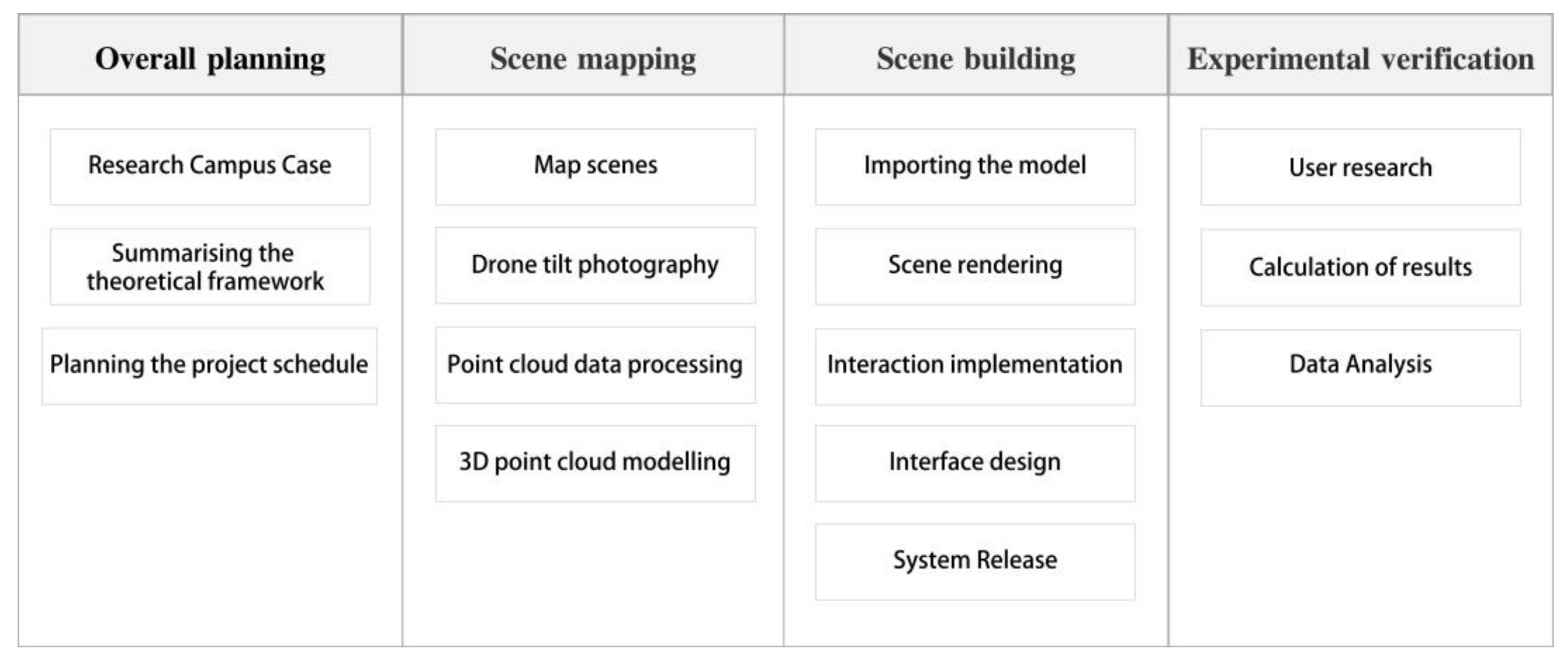
The entire article is structured according to the project-building process and is divided into the following sections, as shown in Figure 1:
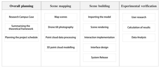
Figure 1.
Structure of the overall article.
- Overall project planning phase: The research has been conducted on many classic smart campus cases and based on this, a smart campus model architecture of digital twin has been proposed. The overall planning idea and framework of the project based on “top-level design, point by point” have been identified.
- Campus data surveying phase: According to the planning requirements of the smart campus system design work, the study has completed the survey and supplementation of the campus environment and space. In the past data collection process, a survey of the physical campus scene was completed using DEM (Digital Elevation Model) and UAV tilt photography technology, and a full-scene 3D model of the physical campus was realized.
- Twin campus scene construction phase: Based on the physical campus 3D model constructed in the second phase, this study has completed the design and development of the smart campus system using the Unity 3D engine, which mainly includes the construction of scene human–computer interaction, human–computer interface, 3D map, and teaching scenes.
- Digital twin smart campus validation phase: A system scalability scale has been used to investigate users and judge the usability as well as ease of learning of the system.
In several areas, including smart aerospace, smart factories, and smart cities, digital twin technology has proven its strength and superiority compared to other technologies built for smart campuses. This study uses digital twin technology to monitor and manage campuses with the following contributions. Firstly, a fully digital representation of the campus was established, mapping the physical and virtual campus in real time with precision to achieve full scenario coverage. Secondly, IoT technology senses and manipulates the campus, with the virtual campus space reacting to the physical campus and providing real-time feedback on the campus. Then, the remote control is supported to enable reverse control of the twin digital campus to the physical campus. The smart campus system based on digital twin technology makes the campus smarter and healthier.
2. Related Works
We believe that the research of IoT technology, virtual reality technology, digital twin technology, wireless sensors, deep learning,3D GIS, and infinite communication technology is closely related to the construction of wisdom [8,9,10,11,12]. As a product of the continuous development and application of the new generation of information technology, digital twin technology realizes the mutual mapping of virtual space and physical space and is mostly applied to the construction process of smart cities and smart factories. However, we believe that digital twin technology is also applicable to the construction of smart campuses and can help advance campus management through virtual-real mapping.
The literature is divided into two parts. The first part describes the application of digital twin technology and the second part will summarize the advantages of applying digital twin technology to smart campuses.
The digital twin is a closed-loop enabling system that focuses on solving real-world problems by creating an automated flow of data between the physical and digital worlds, enabling a connection between reality and reality. Wang et al. state that the digital twin provides an effective simulation method that makes evaluation, prediction, and optimization cheaper and easier than the physical space [13]. Classens et al. state that, in the future, we will apply digital twins and that a generation of fault diagnosis systems will rely on physically based defined models enriched by available real-time data from a large number of sensors and actuators [14]. It has been used in an increasing number of applications in recent years.
Digital twins are being used in smart cities, such as the Xiong’an New Area digital twin city in China [15], the virtual platform in Singapore [16], and the concept and model of the digital twin city are increasingly being adopted as a recognized future direction for cities [17]. Liu et al. introduced digital twins into building interior security management and proposed a framework for an interior security management system based on digital twins, which effectively improved the intelligence of building interior security management [18].
2.1. Digital Twins Applied to Smart Transportation
Won-Tae Kim et al. have proposed a disaster management system based on digital twin technology, where a digital twin of the natural environment can provide accurate disaster prediction services through a hybrid modeling scheme of similarities, and the disaster management system under digital twin technology reduces the probability of disasters by about 50% [19]. As bad weather increases the rate of traffic accidents, Liao et al. have proposed a virtual reality cycling system with multi-sensor fusion, which simulates virtual cycling by capturing cycling speed and rotation angle through sensors and transmitting virtual and real data by Bluetooth [20]. Wu Zhaohui et al. pointed out the application of new technologies, such as building information modeling, virtual reality, digital twin, and autonomous driving in smart transportation, providing a smart transportation solution for China to build a strong transportation country that is satisfactory to the people, powerful in terms of protection, and at the forefront of the world [21].
2.2. Digital Twins Applied to Smart Education
Some schools, led by the University of California, have explored the application of the digital twin on campus and have drawn up a preliminary theoretical foundation, based on theories such as “learning by doing”, which organically combines learners, teachers, digital twins, and group communication [22]. Li Haifeng and Wang Wei et al. summarize the educational model by proposing the digital twin technology to be used in education and teaching in half of the models [23].
Through the analysis of the application of digital twin technology, it is concluded that digital twin technology will bring about radical changes to all aspects of the campus, with typical performances including the mapping of reality and reality to achieve efficient campus management, early warning of security and intuitive and vivid teaching. The Smart Campus Control Platform can help break the status quo of decentralized management, passive response, and over-reliance on personnel for each sub-system in the industry, and build a user-centered system that fully utilizes technologies, such as the Internet of Things and artificial intelligence, to achieve the interoperability of each molecular system, intelligent system prediction, closed-loop management of each business, break the data silos between systems, and ensure unified system operation.
3. Basic Digital Twins Technology and Digital Twin Campus
3.1. Overview of Digital Twins
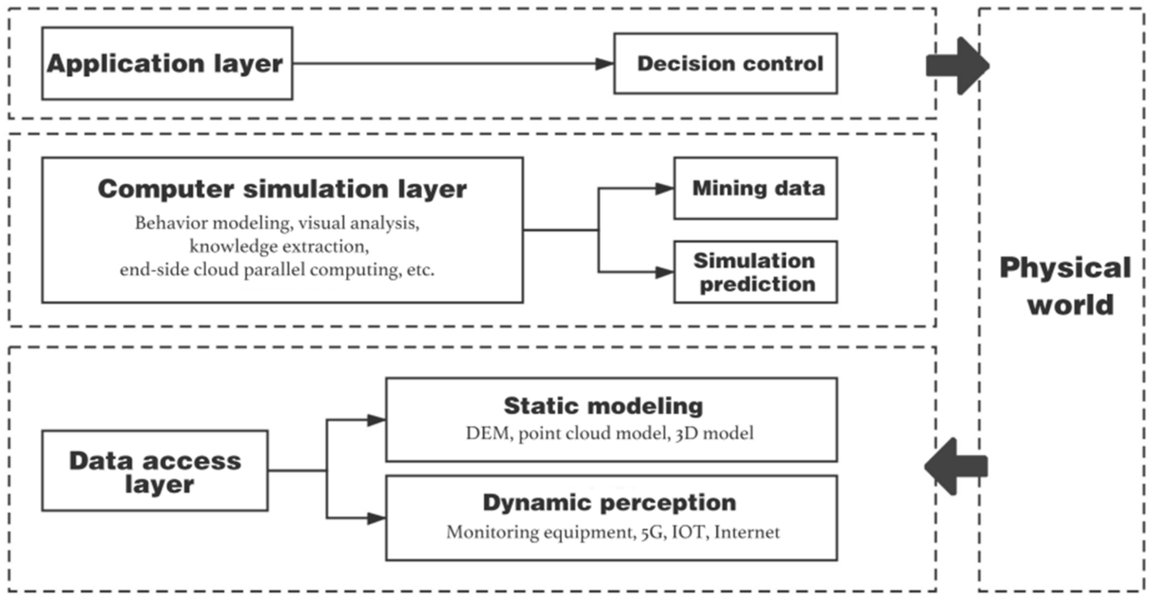
The digital twin is the reconstruction of all elements in virtual space and the digital mapping of product process and state. It is a simulation system in essence and key technology to realize the deep integration of information physics [24,25,26]. The digital twin technology is analyzed from three levels data, namely access, computer simulation, and application. Figure 2 shows the logical architecture of digital twinning.
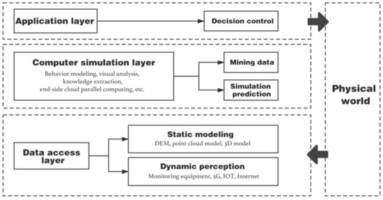
Figure 2.
Digital twin technology architecture.
- (1)
- The data access layer refers to the realization of the measured perception of the physical environment by the static model and the dynamic model.
- (2)
- Calculate the simulation layer, perform data analysis and calculation, and make predictions, and provide key technical support for the application of digital twins.
- (3)
- The application layer controls the result of the decision to the physical entity.
The whole process can verify whether the decision in multiple parallel spaces is reasonable and efficiently optimize the full life cycle of the campus system, thereby affecting and changing the way people interact with the physical world.
3.2. Smart Campus System Architecture of Digital Twins
To thoroughly implement the smart development of campuses, this research introduces digital twin technology to build a digital twin technology campus, which includes five parts: physical domain, virtual domain, service platform, data platform, and connection. The physical space monitors real-time data and uploads them to the data platform for analysis. The analysis results drive it to complete the virtual simulation and propose an optimized plan for the service platform. The service platform ultimately decides the plan in the physical space to help system management. Through the connection to the link, it can operate effectively, transmit data, and realize interaction. Models can drive the connection between physical space and virtual space. The process of perception, prediction, simulation, and decision-making has been carried out many times to continuously optimize campus life.
According to the needs of Considering from all aspects of the campus, the future smart campus should have the following capabilities:
- Provide immersive campus experience;
- Provide visual campus management;
- Improve intelligent campus teaching mode.
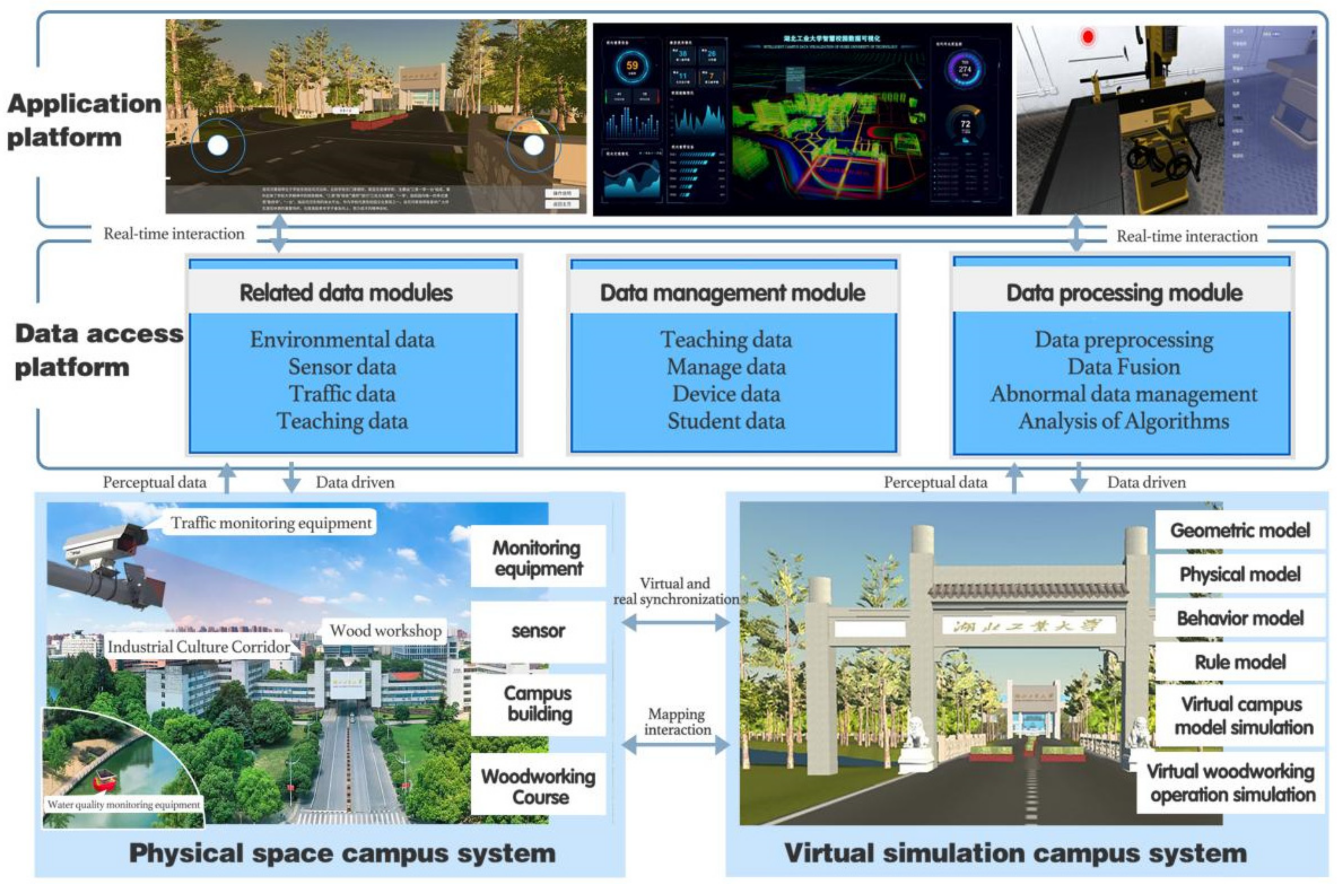
This system has been designed with a campus navigation experience, augmented reality campus, virtual simulation teaching, and campus data visualization functions. The system construction refers to the framework of digital twin technology and proposes a smart campus based on digital twins. The logical structure of the system design is shown in Figure 3.
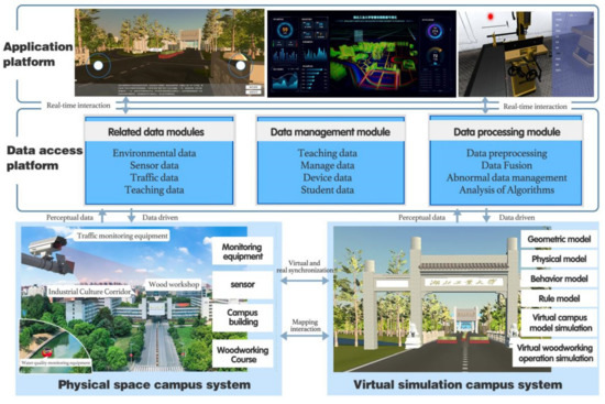
Figure 3.
A logical framework for the Digital Twin Smart Campus.
- (1)
- The physical space campus system uses multi-source equipment to collect various campus data, such as traffic monitoring equipment, water quality testing equipment, teaching feedback systems, etc.
- (2)
- The data access platform includes related data modules, data management modules, and data processing modules. The platform uses SaaS, PaaS, IaaS, etc. to manage, store, simulate, predict, and feedback data.
- (3)
- The virtual simulation campus system is the key technology of the digital twin. First, build a simulation model through oblique photography and 3D software to simulate the working environment. Secondly, import real-time data and historical data to drive the system for virtual simulation. Then, predict the situation of various indicators on the campus, and dynamically map the simulation results synchronously, Finally, guide the real-time optimization and intelligent control of the physical world.
- (4)
- Application platform, which applies virtual simulation results to a visualized application platform. The platform includes virtual tours, AR tours, virtual simulation teaching, visualization of various data, and finally realizes human monitoring and decision-making in a complete loop.
Compared with the traditional one-way smart campus, this process forms a sustainable system full life cycle. The advantage of the spiral development of the smart campus system is that it can reduce the operation and maintenance costs of various equipment on the campus efficiently and optimize the management and teaching work, providing users with a better experience.
4. Our Proposed Intelligent Campus Systems Based on Digital Twin Technology
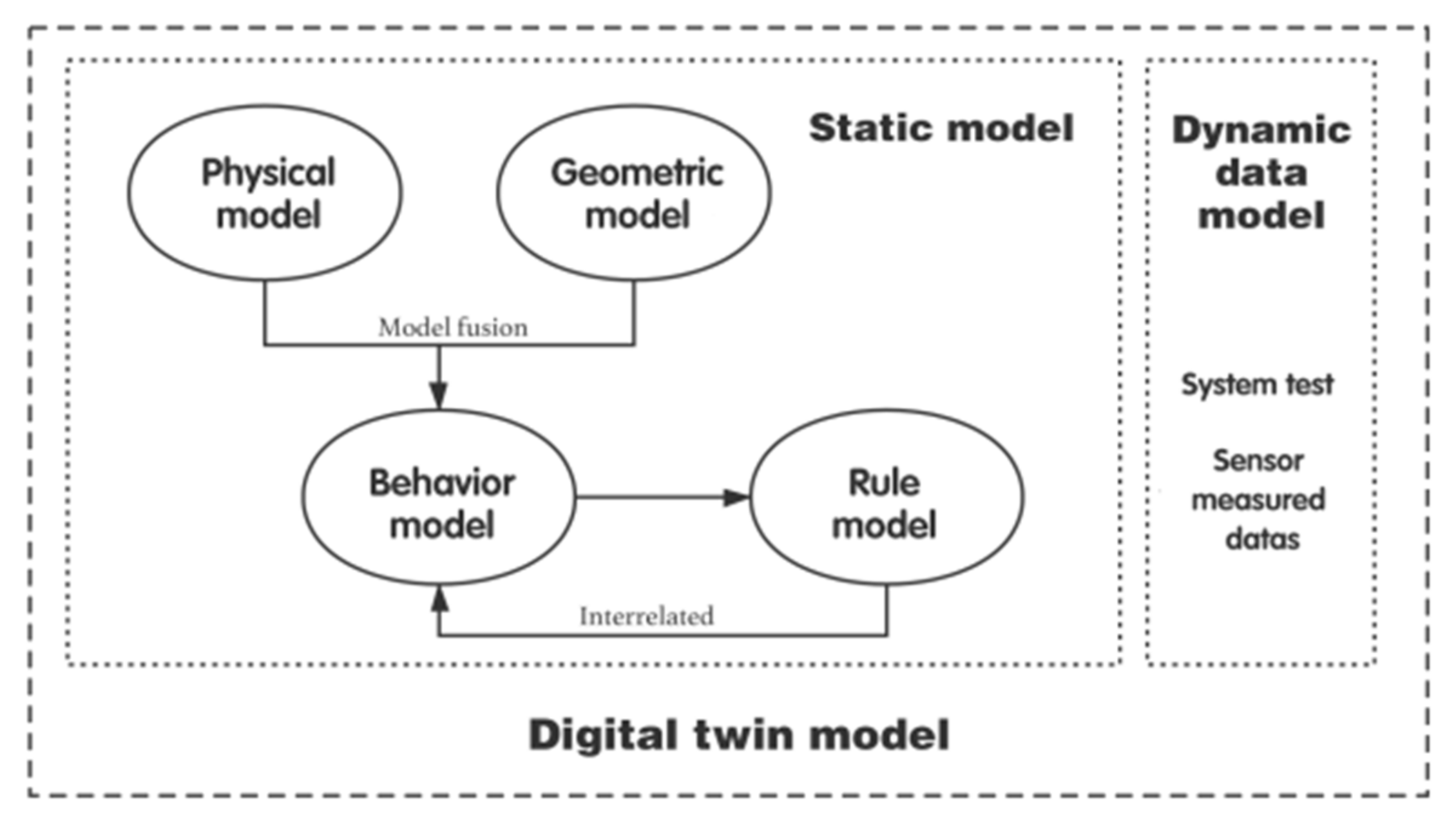
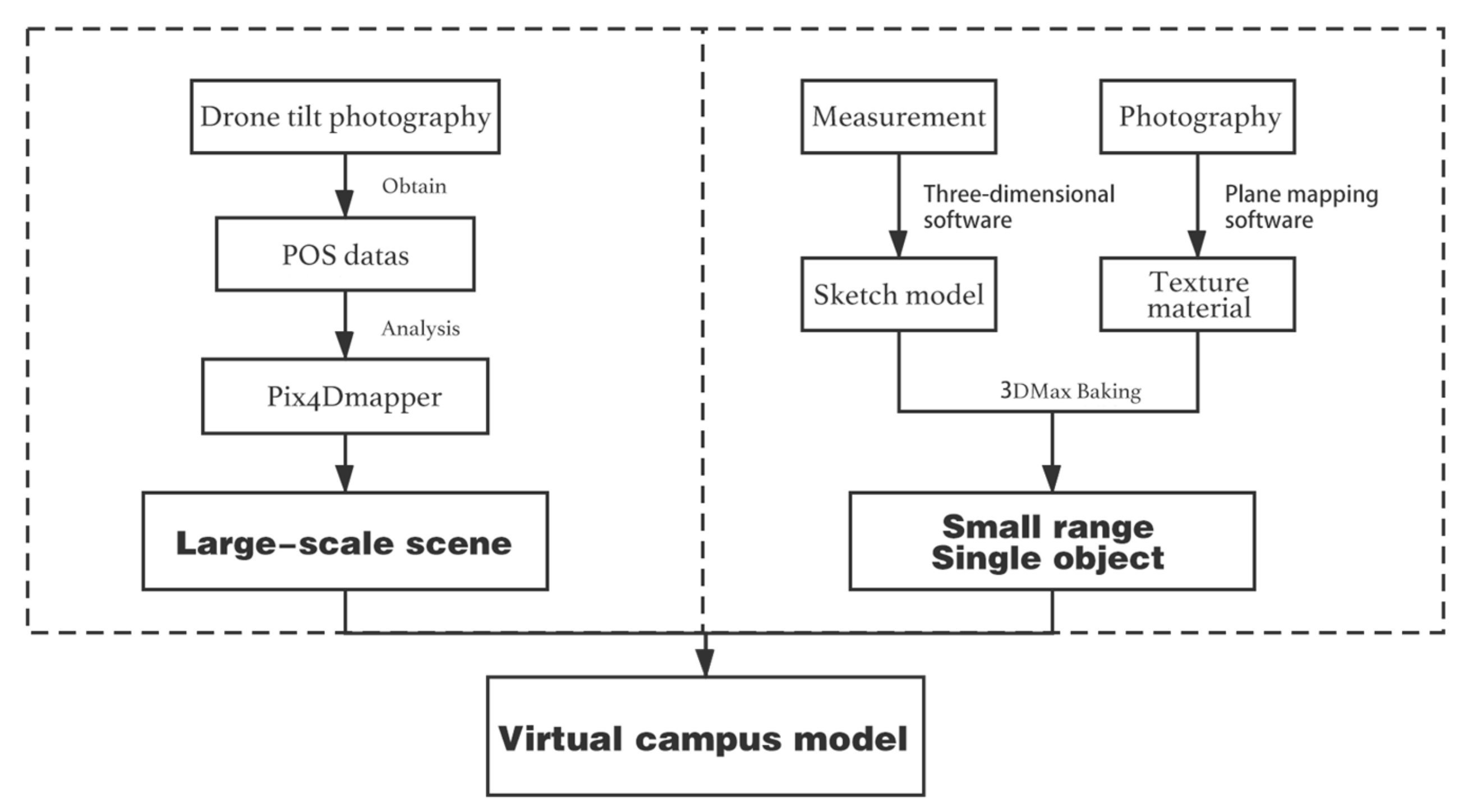
In modern simulation technology, virtual reality technology is very important. The process of developing a virtual simulation of a smart campus is essentially the process of developing its virtual reality content, which realizes the actual measurement simulation of a three-dimensional dynamic scene and entity behavior [27]. This system uses the Hubei University of Technology as a blueprint to build a smart campus system based on digital twins. The system model is jointly constructed by an integrated model of static and massive dynamic data, as shown in Figure 4. First, the drone tilts photography to obtain POS dates and make a point cloud model of the scene. Then, Sketchup and 3Dmax are used to refine the processing model, build an interactive fusion channel based on Unity3D, develop virtual technology, and finally generate and release. In a real sense, a new interactive form of “integration of virtuality and reality, and virtual control of reality” was created, and a smart campus system design scheme with the characteristics of the Hubei University of Technology was formulated.
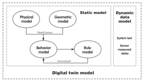
Figure 4.
System Construction process.
4.1. Theoretical Framework
Digital twin technology is an effective means of achieving information–physical convergence [28], focusing on solving real-world problems with the physical world at the center, and creating a closed-loop enabling system of automated data flow between the physical and digital worlds to achieve a link between reality and reality. The digital twin can integrate artificial intelligence, the Internet of Things, and other information technologies to build real-time digital simulation models [29,30].
4.2. Static Model Construction
4.2.1. Presentation of Virtual Scene Layers
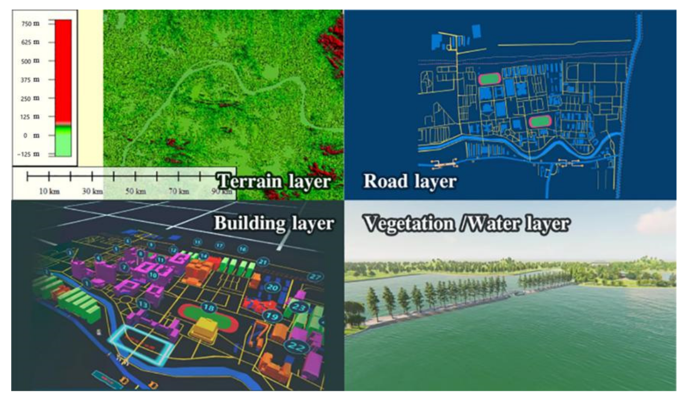
The virtual campus scene layers include terrain layers, road layers, building layers, vegetation layers, and water layers. As shown in Figure 5, the scene layers of the campus are shown.
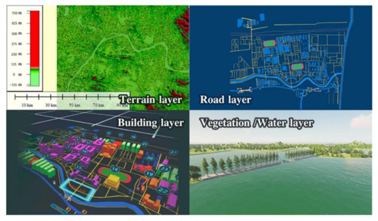
Figure 5.
Scene layers of the campus.
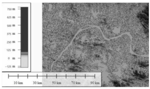
Digital elevation mode is a discrete mathematical expression of the topography of the campus [31], which can best reflect the physical domain scene. The expression of the DEM function formula is Formula (1), which represents a finite sequence of three-dimensional vectors existing on plane D.
Vi = (Xi, Yi, Zi), i = 1, 2, 3,……,n
In the formula, (Xi, Yi) ∈ D is expressed as plane coordinates, and Zi is the elevation corresponding to (Xi, Yi). Based on the center longitude 114.5 and the center latitude 30.5, the data were collected with the aid of ASTER GDEM V2, as shown in Table 1.

Table 1.
Static scene data.
The campus scene data include oblique photography data and building data. First, the UAV is used to obtain aerial photographs of ground objects [32] and the POS data of the scene at vertical and four mutually perpendicular angles. The drone’s oblique photography area is 0.2 km2, the actual area is 0.16 km2, the navigation speed during the shooting process is 50 km/h, the altitude is 30–50 m, the horizontal accuracy is 5000 m, the vertical accuracy is 10,000 m, and the POS data are obtained through 1106 images, as Table 1 shows. Obtain the size of the campus building according to Google Earth or drawings and build the model in equal proportions. Take pictures of building materials to form a material library.
4.2.2. Presentation of 3D Solid Models
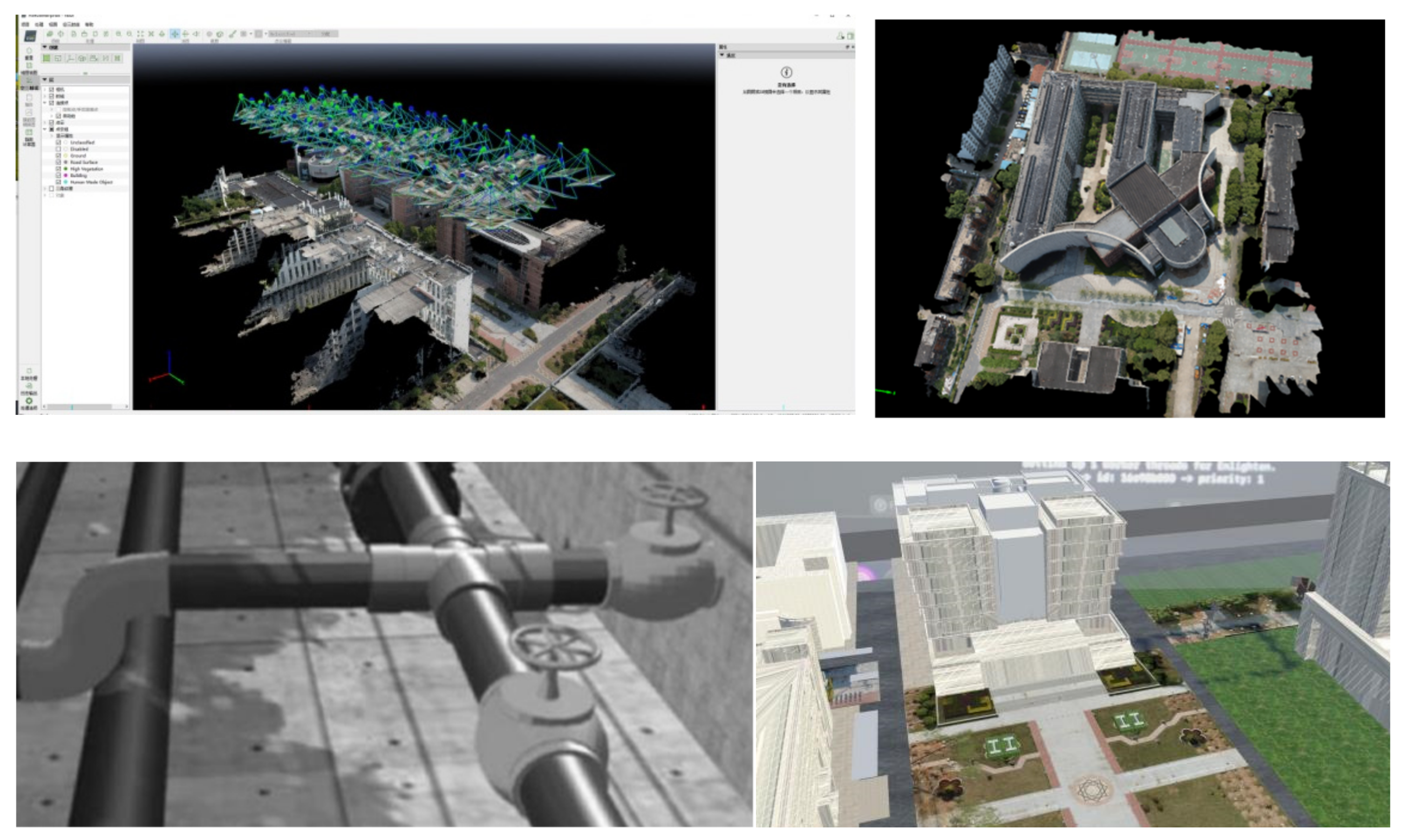
To realize a virtual smart campus system, the construction of a three-dimensional model becomes a top priority, as shown in Figure 6.
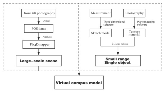
Figure 6.
Campus scene geometric model construction.
Because of the difference in characteristics, different modeling methods are adopted: oblique photography modeling and manual modeling. The former has the advantages of high efficiency and low cost, but the details are quite different, and manual modeling can just complete a more refined model. Combining the two modeling methods can better express the real campus scene and teaching scene, as shown in Table 2.

Table 2.
Comparison of modeling methods.
Oblique photography modeling is used to import the acquired image data, POS data, and control point data into Pix4Dmapper. Preprocess the data registration, denoising, streamlining, and adjusting the data. Apply the default WGS84 coordinates of the software, set the POS data coordinate system, then analyze and match the feature points of the image, GPS geographic positioning, point cloud encryption (point production, point filtering), digital surface model, and orthoimage generation. Complete the three-dimensional construction of the real campus terrain, as shown in Figure 7.
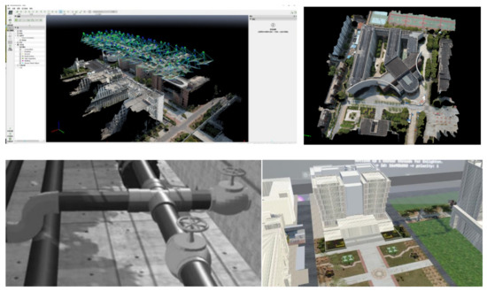
Figure 7.
Point cloud modeling and artificial modeling.
In terms of manual modeling, first, plan the campus buildings and teaching equipment by partition, and draw the outline map, import it into 3D Max and Sketchup software, stretch, chamfer, cut, and other operations, make a simulation model of the product, highlight its characteristics, and export the completed model FBX format. Secondly, collect building and equipment materials in real scenes, and use Unity ArtEngine’s powerful AI auxiliary functions to complete high-realistic product materials. Finally, in 3D Max, the diffuse reflection method is used for mapping, and the baking technology is used to further adjust the model material and lighting parameters, and the material is baked into a texture and applied to the scene [33]. The whole process completes the production and rendering of buildings and equipment, as shown in Figure 6, which shows the manual modeling results of the steam engine.
We need to digitally mark the model of the space to enable rapid indexing, location, and association of information to the campus scene. Various types of sensors collect information on the attributes of the physical space, which can be updated by digitally marking the code.
4.3. Dynamic Data Integration Model
The dynamic data model includes data, such as personnel, environment, equipment, faults sensed in the physical space, model data, simulation data, management data, predictive evaluation data, etc. in the virtual space, dynamic data provide data provisioning capabilities for the virtual campus. The application of edge computing provides data-based services in a distributed storage and computing mode at the edge nodes of the network [34]. The data are continuously updated and iterated, which improves the efficiency of data fusion analysis and helps the virtual domain model to be mapped more accurately.
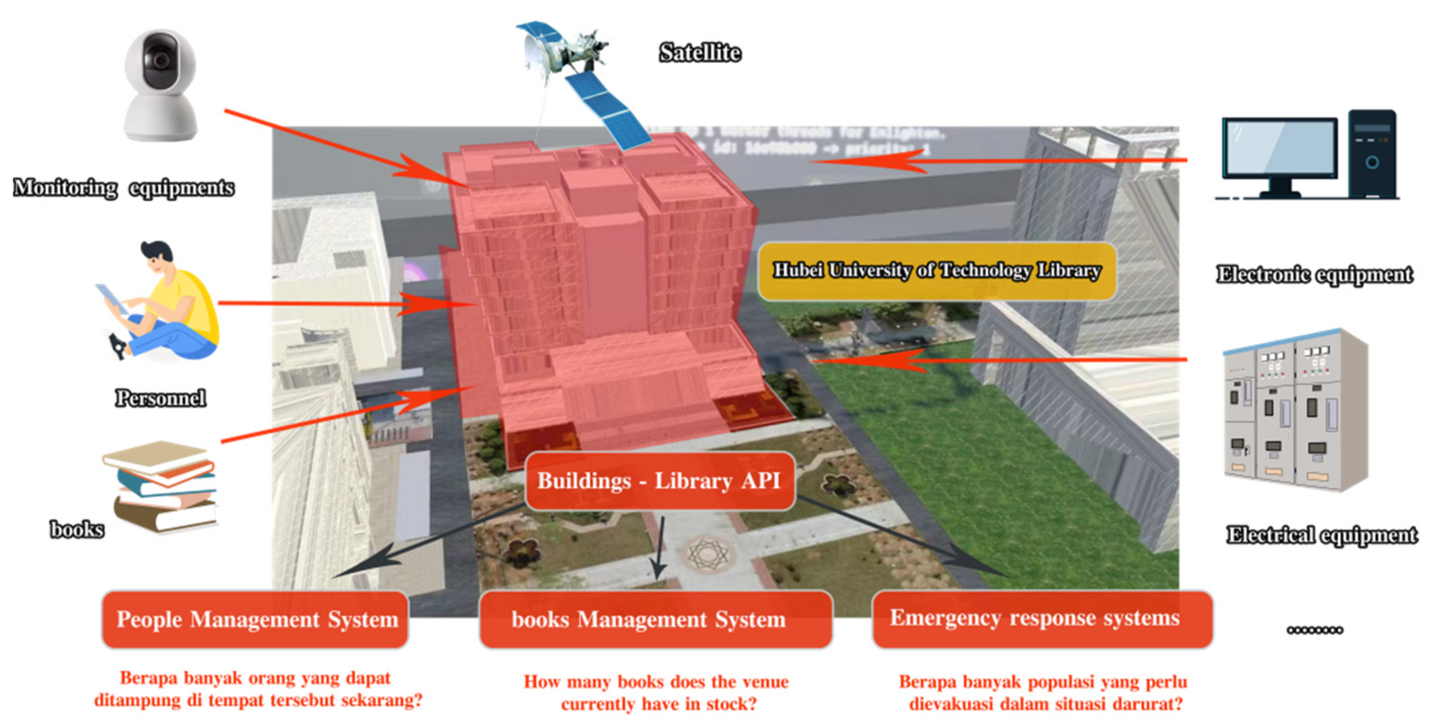
This study will take the library, a landmark building of the university, as an example to detail how to achieve campus data integration. With the library as the associated identifier, data integration is achieved through dynamic data collection by associating various attribute information of the library in multiple dimensions, such as people, books, and electrical systems, and ultimately monitoring and decision-making for each monitoring module, as detailed in Figure 8.
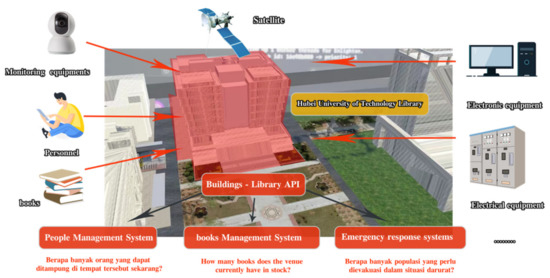
Figure 8.
Dynamic data presentation in the library.
Dynamic data exist not only in individual elements, but also in the integration of data between elements, such as the flow of students in classes, associated with many elements. The system can support the interface between data monitored in real-time and data recorded historically, ultimately enabling the correlation of campus data.
4.4. Framework of Smart Campus System
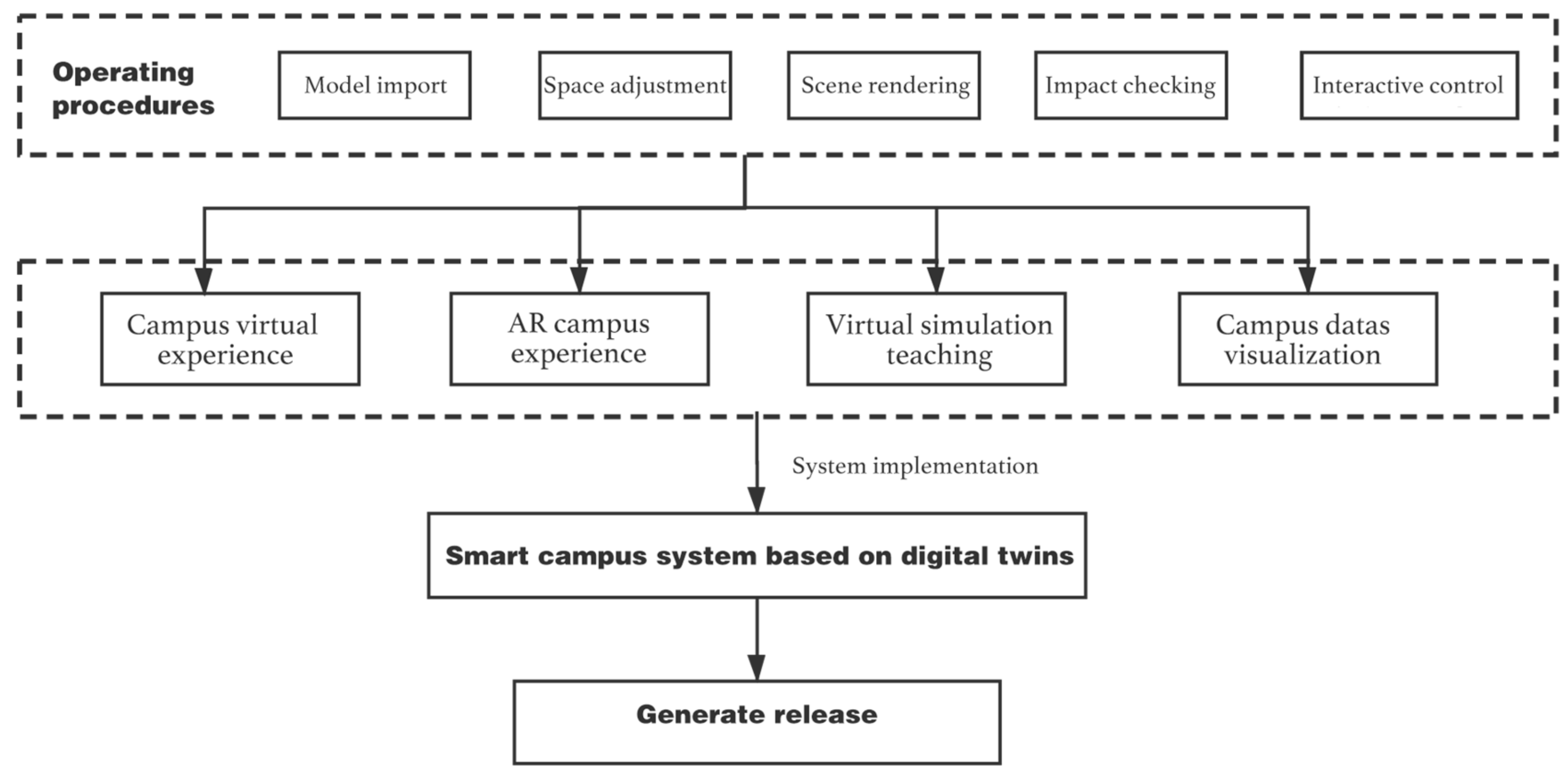
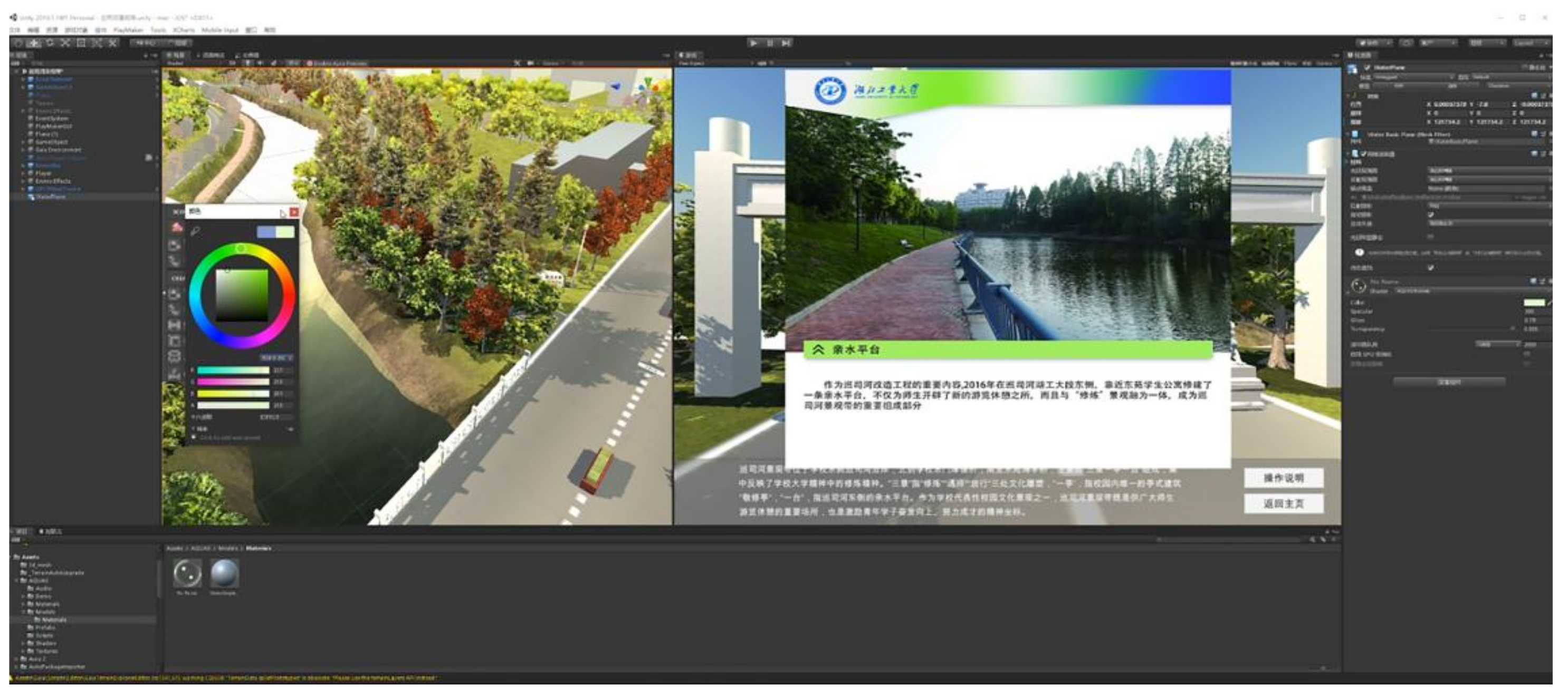
The use of the Unity 3D engine to build a virtual simulation campus system has the advantages of strong tolerance, stable system operation, and diversified interactive forms [35]. The system specifically implements the following operational procedures: model import, space adjustment, scene rendering, collision detection, interactive control, and other functional requirements. Apply the system operation process to each functional section, and formulate a system design plan with campus characteristics, as shown in Figure 9 and Figure 10.
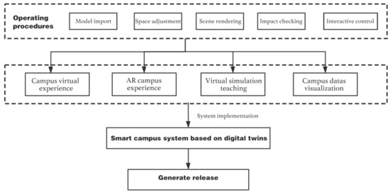
Figure 9.
System implementation.
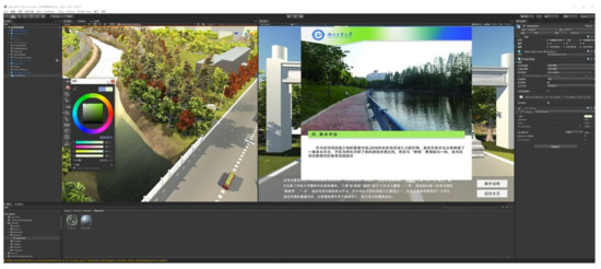
Figure 10.
Unity3D implementation of scene manipulation.
5. The Specific Smart Campus System
The use of Unity 3D Engine to build a virtual simulation campus system has the advantages of strong tolerance, stable system operation, and diversified interactive forms. Throughout the construction process of the twin smart campus system, we have applied the entire operation process to the main campus building, campus cultural building, campus ecological environment, and teaching classroom, ultimately realizing a smart campus system solution that integrates reality with reality.
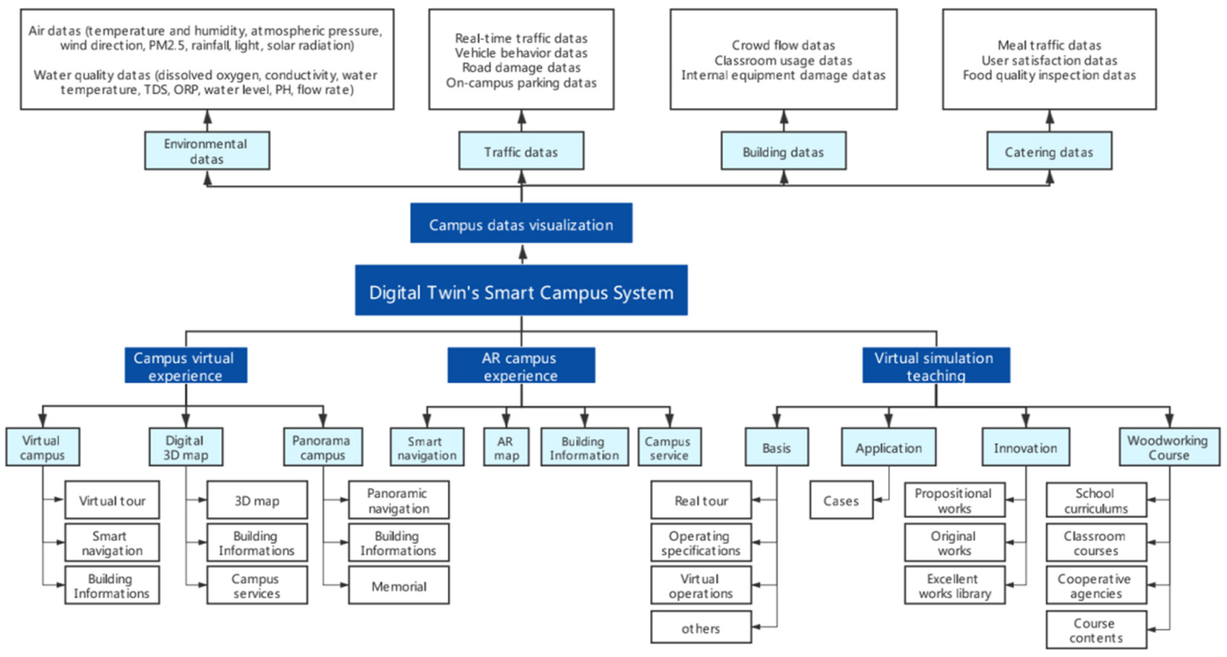
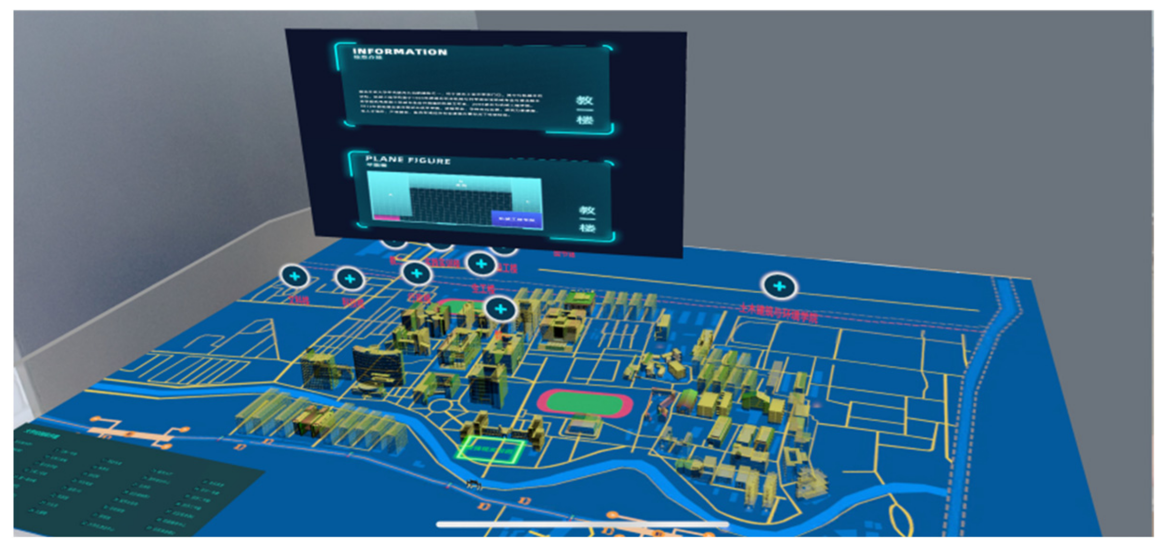
This study has completed the construction of the campus virtual scenario and the realization of the supply of data in the virtual scenario in Section 4, and the logical closure of the fusion monitoring, analysis, prevention, and decision-making through data fusion. This system uses the “Hubei University of Technology” as a case to design a mobile terminal “smart campus” application system. The functional modules required by users are designed for different roles on campus. The digital twin technology-based smart campus system mainly has the following functions: campus navigation experience, campus data visualization, augmented reality campus, and virtual simulation teaching, as shown in Figure 11.
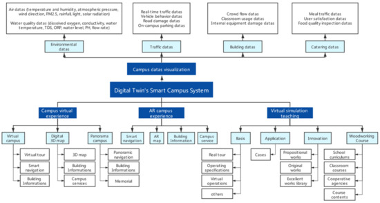
Figure 11.
Digital twin smart campus system.
Based on the above diagram, the system is divided into four main functional modules with the following main functions.
- (1)
- Campus navigation experience: It can support users to experience the campus in an immersive way. Users can walk into the virtual campus space and experience the beautiful scenery of the campus, and this function module supports three types of tours: fully immersive VR tour, semi-immersive panoramic campus, and three-dimensional 3D digital map, which can allow users to better understand and feel the campus landscape and culture.
- (2)
- Augmented Reality Campus: The augmented reality campus also works as a way to promote campus culture, already providing users with smart navigation, AR maps, and process services. However, what is essentially different from the former is that the former is a way for users to walk into a virtual space and feel it, while the AR function is a way to show the information of the virtual campus in a physical space, providing a new way for users.
- (3)
- Campus data visualization: The twin campus has achieved access to real-time and historical data on the environment, traffic, buildings, and dining to help managers understand the current status of the campus. The visualization of campus scenes can achieve controlled scene monitoring and simulation extrapolation. For example, we can accurately determine the source of sewage in the river Patuxent by detecting the nitrogen, sulfur, and phosphorus content of the river.
- (4)
- Virtual simulation teaching: The study is a digital display of our excellent and innovative woodworking courses, mainly covering four functions basic courses, actual cases, innovative works, and cooperative courses. Through virtual space for more intuitive learning, students can perform virtual hands-on exercises and the system can monitor the course learning, which can greatly enhance the learning effect of the courses.
5.1. Campus Guided Tour Experience
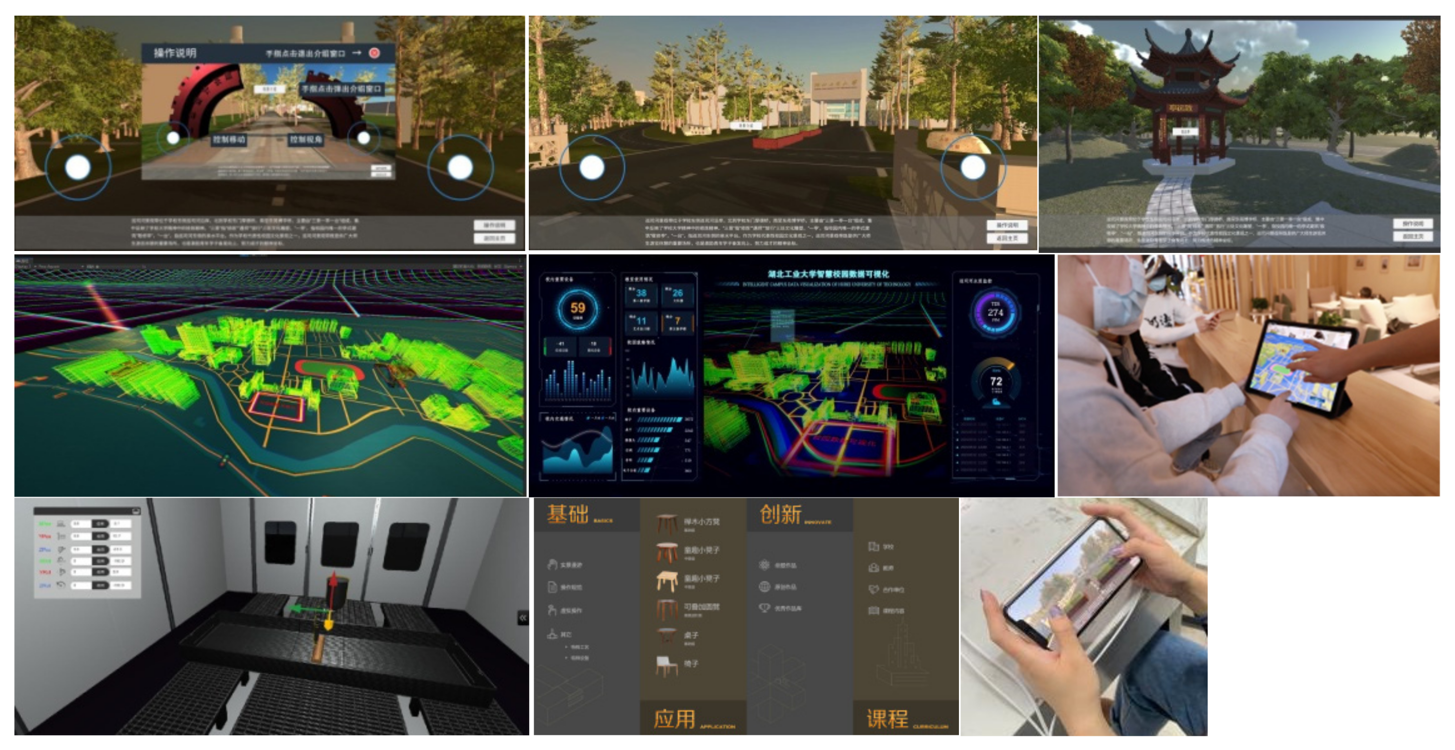
The campus is developed based on Unity 3D, providing users with an immersive roaming experience, and they can enjoy the three-dimensional panorama of the campus without leaving home. The system uses sensors to monitor user location information, behavior information, operating habits, etc., to provide users with more precise and personalized Service, a multi-mode navigation experience for users to choose from, bring users a unique experience, and promote the spread of campus culture. As shown in Figure 12, different environments in the campus scene are demonstrated.

Figure 12.
Presentation of the different environments of the virtual campus.
Based on the Monodelevop script editor C# language in Unity3D, the design of the campus tour is to load the script to the camera and the target model to realize the interactive process. The main script contains:
- button event, Button, click event, and click interaction of scene UI;
- DesktopTreesPackage, the Speedtree placed by plants in the scene changes randomly;
- CameraController, its camera moves according to joystick touch, and assigns moving speed variable;
- CameraRefocus, according to the Vector3 space vector, the switch, and change of the camera focus of the scene;
- UI Tips, the picture information in the scene is automatically hidden and clicked to call;
- Scene jump, interface jump;
- Touch Camera realizes the gesture control in the scene to control the camera’s angle of view rotation and zooming in and out;
- PlayerMove Controller, Rigibody realizes the movement of characters;
- Joystick, which realizes the movement and steering of the characters and the camera controlled by the joystick;
- Timed Object Activator, time changes in the scene, day and night switching;
- Look At MainCamera, the model is always facing the camera and can change its direction with the movement of its orientation.
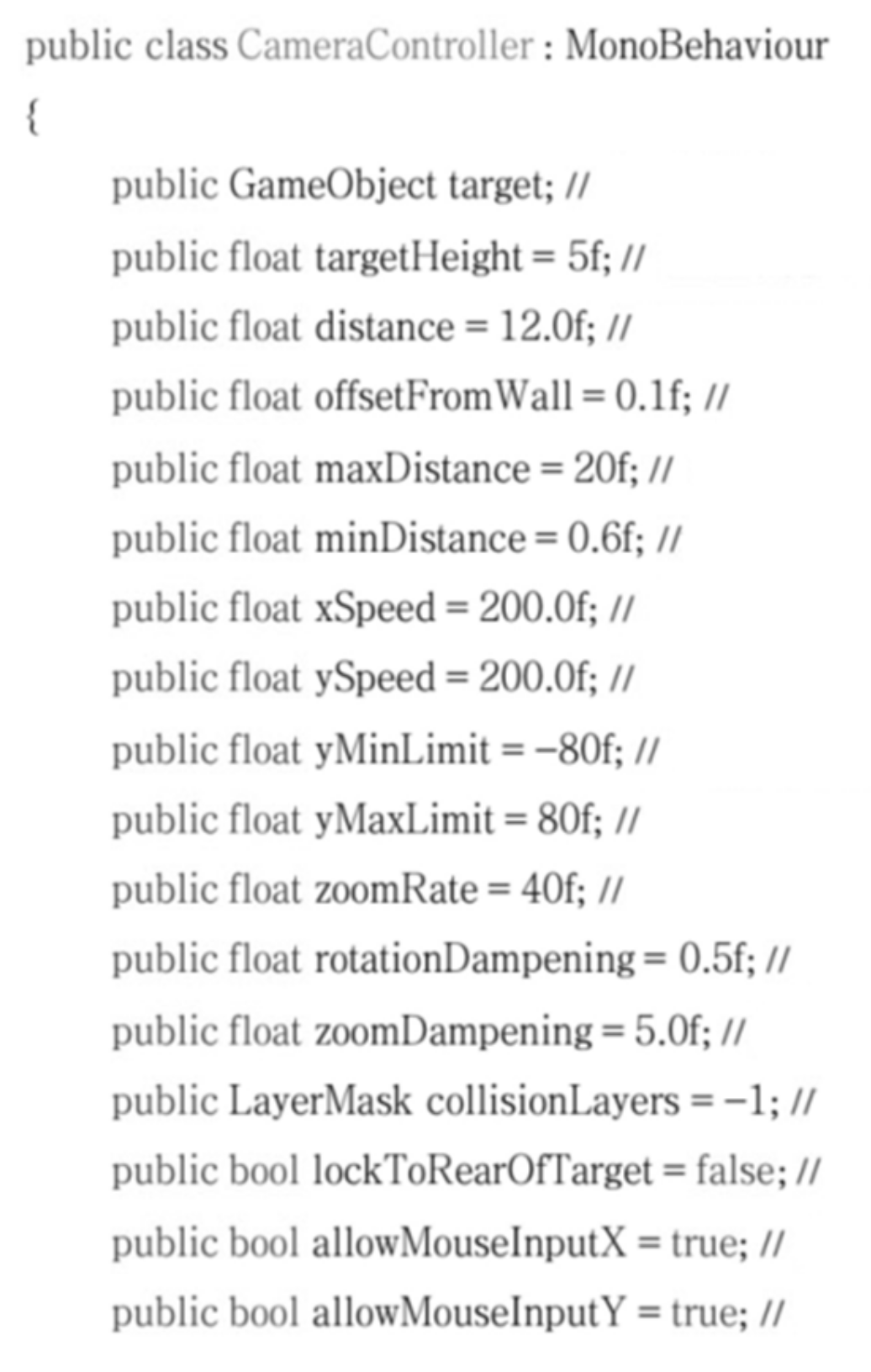
The important code design of the campus navigation function Camera Controller to control the moving speed variable is shown in Figure 13.
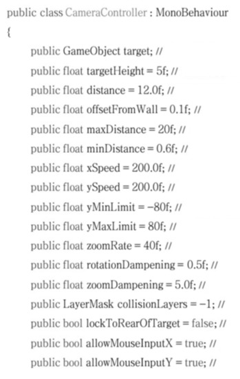
Figure 13.
The camera Controller controls the moving speed variable part of the code.
5.2. Augmented Reality Campus
The system uses AR Foundation in Unity3D to build this function. Open campus scene—iOS and Android platform settings—ARSessionOrigin build a scene—move 3D Object to Cube—set Scale—Trackable Managers to track objects—add level detection AR Plane Manager—add AR Default Plane in Hierarchy—generate prefab—add feature points Cloud—add ray detection—add script. Finally, we can experience the campus system of augmented reality in the system. The virtual campus for AR is shown in Figure 14.
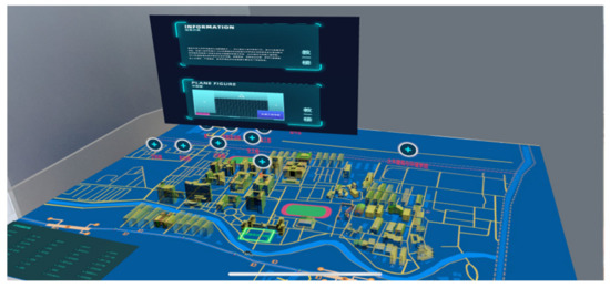
Figure 14.
Smart campus in the form of AR.
Virtual reality, augmented reality, and mixed reality are called 3R technologies. Applying them to campuses is an effective means of realizing digital twin interaction and collaboration [33]. The digital twin technology is used to monitor the campus environment, and the twins perform a virtual simulation to achieve real-time control of the physical domain, effective optimization from multiple angles, and complete campus management for decision-making. For example, in the hot summer, the sensor device monitors the temperature and presents it in the AR scene, observes the discoloration of the building’s appearance, and provides the school with the best cooling and energy-saving decision-making plan to apply to the campus based on the actual measurement and historical data model analysis and virtual simulation. At the same time, users can also use the AR navigation and other functions available to experience semi-immersive tours.
5.3. Virtual Simulation Teaching
Using science and technology to empower education, through the realistic interaction of the environment, interpersonal interaction, and self-imagining, can bring people the characteristics of immersion, interactivity, and imagination [36].
The woodworking course based on simulation technology has a visualized operation process and an immersive learning experience, which can reduce the occurrence of teaching accidents and ensure the safety of teaching. The Animation Controller in Unity3D is used to realize the teaching function. First, add the woodworking course teaching animation-create animator component management, double-click to enter the Animation Controller, create a new clip create new clip-adjust the animation time, and add object scripts to realize virtual space teaching simulation. As shown in Figure 15, the operating system for the virtual woodworking course on campus is demonstrated.

Figure 15.
Operating system of the virtual woodworking laboratory.
Taking digital twin technology as the basic point of understanding, mining teaching data, exploring personalized teaching plans, innovating teaching methods, and improving the governance and application of the teaching environment represent a certain forward-looking value for cultivating future innovative talents [37]. The integration of digital twins and education and teaching also refreshes people’s redefinition of the education industry.
5.4. Visualization of Campus Data
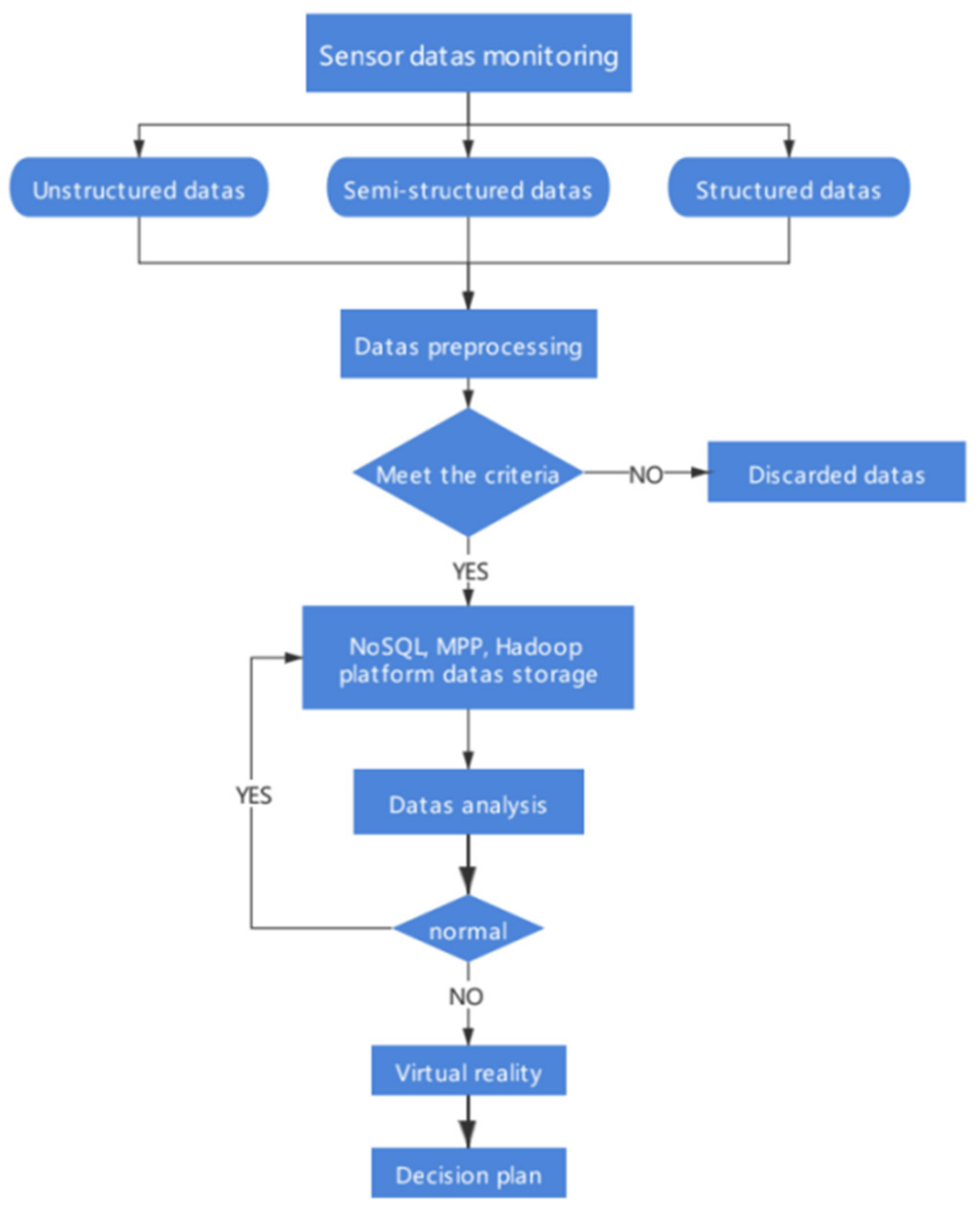
Visualize campus data through monitoring and application to the entire system. In the process of building visualization, it visualizes the progress of the campus environment, construction, transportation, and catering. By comparing real-time data with predicted data, it can be judged whether various indicators are normal. The specific data monitoring process is shown in Figure 9. The sensors are used to monitor real-time data on campus, the monitored data (structured data, semi-structured data, unstructured data) are synchronously transmitted for data preprocessing, and the eligible data are stored in the cloud, Use computer collaboration technology to integrate, analyze, and mine massive, multi-source governance data, store normal data as historical data in the cloud, improve the accuracy of data analysis, analyze abnormal data, perform virtual simulation operations, and finally propose the best. The decision-making plan realizes the closed-loop system and helps the campus management to continuously optimize.
The main functions of DT Technology’s Smart Campus serve different user roles. For example, two functions, Campus Guided Experience and Augmented Reality Campus, can serve anyone, and the development of this function can greatly enhance the cultural image of the campus. The virtual simulation teaching function, on the other hand, has been developed mainly for students at school and teachers of woodworking courses. Intuitive teaching methods and real-time learning monitoring can greatly improve the effectiveness of the courses. The data visualization function is more for the campus management, such as the security office and the logistics office.
6. System Application Analysis
6.1. Research Results
The system availability scale is one of the commonly used report metrics for evaluating the availability and effectiveness of the system, and it is the most representative scale [38]. Aaron Bangor et al. collected system availability scale (SUS) data at all stages of the life cycle for analysis, and the results showed that SUS is a universal tool for high compliance assessment [39].
The scale consists of 10 simple questions, where odd-numbered items are positive statements, and even-numbered items are negative statements. After experiencing the system, the tester is required to give 5 points to the system based on user experience. Questions 4 and 10 constitute the system’s learnability subscale, and the remaining questions constitute the system usability subscale. The final score is calculated according to the following formula, the total score is calculated by Formula (2), the system availability is calculated by Formula (3), and Formula (4) is the ease of system learning.
G = 2.5 (Sood − Seven + 20)
GA = 12.5 (n4 + n10 − 2)
GL = 3.125 (G − n4 − n10 + 2)
According to the relationship between the acceptable range of users and the SUS score proposed by Bangor, those with a score of 73 and above are considered to have a good user experience. Figure 16 and Figure 17 shows the system and user experience process.
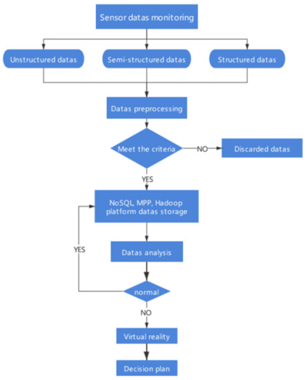
Figure 16.
Data monitoring and analysis process.
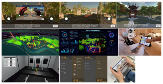
Figure 17.
Functions of the smart campus system and user experience.
Based on the different functional modules serving different user roles in the project development, Table 3 was compiled to introduce the relationship between the system’s usage roles, functions, and the users’ evaluation criteria. These roles were invited to participate in the experience phase of the project, and all roles were given one week to use the system, after which they were given a comprehensive score for the smart campus system based on the system usability scale.

Table 3.
Systematic evaluation criteria.
Firstly, current students, teachers, retired teachers, and graduate students were invited to use the Campus Tour and AR Campus features, scoring full marks according to: 1. no problems in basic operation and being able to navigate around the campus; 2. medium marks if they could use the system basically and felt good about it, and 3. zero marks if they could not understand the system and had difficulties using it.
Secondly, in-service teachers and students were invited to participate in the virtual teaching function, answering the questions posed by the system based on the criteria: 1. the time taken to receive knowledge; 2. the error rate in operating the woodwork; and 3. the quality of the student’s final output.
Finally, staff from the logistics and security offices were invited to participate in the data visualization process, based on: 1. the probability of emergencies; 2. trends in environmental, traffic, and other data; and 3. the cost of management and maintenance.
The exact process of the experience is shown in Figure 14. The different user experiences correspond to the modules and are scored on a five-point scale according to the scoring criteria and questionnaire responses. A total of 426 questionnaires were output, of which 413 were valid. The results are shown in Table 4, Table 5, Table 6 and Table 7.

Table 4.
Questionnaire contents.

Table 5.
Total system availability scale results.

Table 6.
System Usability Scale results.

Table 7.
Systematic learnability results.
The 413 valid questionnaires were collated and analyzed. We first collected questionnaires for individual functions, calculated the mean score for each function, then integrated the four functions to calculate the mean score, and finally retained the results to three decimal places.
According to the comparative analysis of the SUS general database proposed by Jeff Sauro, the results show that the overall availability data result is 78.281 (>73), which meets the B+ level (77.2–78.8). The result of the usability subscale was 77.739, which also reached the B+ level, and the system learnability survey was 80.447, which was in line with the A− level (78.9–80.7) in the scale. Participants generally report that the system is simple and easy to operate, which helps users have a deeper understanding of the campus.
6.2. Comparison with Other Smart Campuses
A truly intelligent campus has to meet services, real-time monitoring of the school, rational analysis, prognosis, to making decisions for the campus. At present, Beijing University of Aeronautics and Astronautics is at the forefront of building a smart campus. Based on the concept of “Internet+”, Beihang has built the ihome integrated application platform, which mainly includes ihome+ teaching, ihome+ management, ihome+ services and ihome+ community space. In teaching services, online courses and teaching evaluation have been provided, and in management, students, personnel, finance, assets and office integration have been integrated and coordinated, as shown in Table 8.

Table 8.
Comparison with ihome.
In contrast to the ihome system, its wisdom is reflected in the integrated and integrated campus service function, which focuses on serving teachers and students and monitoring the environment, traffic, teaching, etc. Pre-judgement and decision-making of campus scenarios are neglected in the whole system. The HUT system based on the digital twin has been able to make up for the pre-judgment and decision-making, forming a closed loop of campus services.
7. Conclusions and the Future Work
Technology empowers the rapid development of campus intelligence and better promotes the application and implementation of digital twin technology. Based on explaining the concept, technical characteristics, and logical structure of the digital twin, this system combines the top-level design and construction goals of the smart campus to propose a sustainable digital twin campus. In the course of practice. Firstly, we have completed the collection of spatial data for the physical campus scenes. Secondly, we have also completed the work of digitally representing the full elements of the scene, which include building level, road level, river level, vegetation level, and terrain level. Then, the state of the physical space running in real-time is sensed through sensing technology, and the simulation of the system is developed in Unity3D.
Our twin smart campus system can do the following. First, real-time campus data sensing, which has been completed to digitally mark the physical campus, build graphics (e.g., terrain, roads, greenery, water) and physical models (e.g., building entities, traffic entities, facility entities, underground pipelines, etc.) of the scene, and use the markers to achieve data updates to the scene. Secondly, with the campus data model fusion, the twin campus can understand the real-time traffic status by accessing environmental data, traffic data, building data, and dining data, and accurately discover the source of sewage in the patrol river, to achieve the visualization of the campus scene, which can achieve the scene monitoring controllable and simulation deduction. Finally, the virtual-real fusion interaction of the campus space realizes the real-time rendering of the natural campus scenes and teaching scenes through the graphics engine, realizing the integration of multiple terminals for real presentation. The two-way fusion interaction allows users to enter the virtual campus and achieve zero-touch roaming campus and learning, while the virtual campus can also react to the physical campus, such as AR technology, to experience the industrial culture of the university and enhance campus culture promotion through virtual interaction.
Users are invited to participate in the digital twin smart campus experience, and research shows that users believe that having this system will greatly reduce campus operation and maintenance costs, improve the campus environment, and enhance the quality of teaching and learning. The smart campus based on digital twin technology brings new opportunities and challenges for digital, intelligent, and efficient development and innovation in universities. Of course, the current depth of application of digital twin technology in campus scenarios is still far from adequate, and we will continue to persist on this path and make the campus system increasingly perfect from a more subtle perspective.
Author Contributions
Conceptualization, X.H., H.Y. and X.Z.; methodology, W.Y., C.H., B.T. and X.H; software, X.H., H.Y. and X.Z.; validation, W.Y., C.H., X.Z. and B.T.; formal analysis, C.H., W.Y. and B.T; writing—original draft preparation, B.T., X.H. and H.Y.; writing—review and editing, W.Y., H.Y., X.H., B.T. and N.N.X.; supervision, B.T., X.H. and N.N.X.; project administration, B.T. and X.H.; funding acquisition, B.T. and X.H. All authors have read and agreed to the published version of the manuscript.
Funding
This work is supported by Youth Foundation of Social Science and Humanity, China Ministry of Education (Grants no. 20YJC760025), the Major Project of Research on Philosophy and Social Science of Higher Education Institutions in Hubei Province (21ZD054), the Major Project of Hubei Key Laboratory of intelligent transportation technology and device in Hubei Polytechnic University (2022XZ106), the scientific research project of Hubei Provincial Department of Education (Grants no. q20191402), the Funding of The Innovation and Entrepreneurship Program for College Students of the Ministry of Education of China (Grants no. 201810500024), the Key Projects of the Open Fund of the Hubei Cultural and Creative Industrialization Design and Research Center (Grants no. HBCY201901 and Grants no. HBCY2005), the Funding of The Innovation and Entrepreneurship Program for College Students of the Education department of Hubei province, China (Grants no. 201910500044), and the Innovation and the green technology leadership program of the Hubei University of Technology (Grants no. CPYF2018009).
Institutional Review Board Statement
Not applicable.
Informed Consent Statement
Not applicable.
Data Availability Statement
Not applicable.
Conflicts of Interest
The authors declare no conflict of interest.
References
- Xinhua News Agency. The Fourteenth Five-Year Plan for the National Economic and Social Development of the People’s Republic of China and the Outline of the 2035 Vision Goals. China Water Resour. 2021, 6, 1–38. [Google Scholar]
- Meng, L.L.; Ji, K.; Wang, J.Q. Development of web-based virtual campus roaming system. Comput. Eng. Des. 2021, 42, 896–901. [Google Scholar]
- Song, N.Q.; Zheng, Z.Y.; Zhou, Y.L.H. Big data empowerment and direction of basic education evaluation reform in the new era. China Audio-Visual Educ. 2021, 02, 1–7. [Google Scholar]
- Torres-Sospedra, J.; Avariento, J.; Rambla, D.; Montoliu, R.; Casteleyn, S.; Benedito-Bordonau, M.; Gould, M.; Huerta, J. Enhancing integrated indoor/outdoor mobility in a smart campus. Int. J. Geogr. Inf. Sci. 2015, 29, 1955–1968. [Google Scholar] [CrossRef]
- Chang, K.M.; Dzeng, R.J.; Wu, Y.J. An Automated IoT Visualization BIM Platform for Decision Support in Facilities Management. Appl. Sci. 2018, 8, 1086. [Google Scholar] [CrossRef]
- Li, Z.M.; Lu, C.; Wang, J.L.; Li, F.H. Design and Application of Intelligent Monitoring and Management System for Campus Weak Current Pipeline Network Based on IoT+GIS Technology. J. Shenzhen Univ. 2020, 37 (Suppl. 1), 155–159. [Google Scholar]
- Chen, L.; Wang, W.; Li, P.P.; Li, B.B. Study on the essence of wisdom in the smart campus: On the “lack of wisdom” and the construction strategy of the smart campus. J. Distance Educ. 2016, 34, 17–24. [Google Scholar]
- Lin, C.; He, Y.-X.; Xiong, N. An energy-efficient dynamic power management in wireless sensor networks. In Proceedings of the 2006 Fifth International Symposium on Parallel and Distributed Computing, Timisoara, Romania, 6–9 July 2006. [Google Scholar]
- Xia, F.; Hao, R.; Li, J.; Xiong, N.; Yang, L.T.; Zhang, Y. Adaptive GTS allocation in IEEE 802.15. 4 for real-time wireless sensor networks. J. Syst. Archit. 2013, 59, 1231–1242. [Google Scholar] [CrossRef]
- Kumar, P.; Kumar, R.; Srivastava, G.; Gupta, G.P.; Tripathi, R.; Gadekallu, T.R.; Xiong, N.N. PPSF: A privacy-preserving and secure framework using blockchain-based machine-learning for IoT-driven smart cities. IEEE Trans. Netw. Sci. Eng. 2021, 8, 2326–2341. [Google Scholar] [CrossRef]
- Yao, Y.; Xiong, N.; Park, J.H.; Ma, L.; Liu, J. Privacy-preserving max/min query in two-tiered wireless sensor networks. Comput. Math. Appl. 2013, 65, 1318–1325. [Google Scholar] [CrossRef]
- Huang, S.; Zeng, Z.; Ota, K.; Dong, M.; Wang, T.; Xiong, N.N. An intelligent collaboration trust interconnections system for mobile information control in ubiquitous 5G networks. IEEE Trans. Netw. Sci. Eng. 2020, 8, 347–365. [Google Scholar] [CrossRef]
- Wang, Y.T.; Cao, Y.S.; Wang, F.Y. Anomaly Detection in Digital Twin Model. In Proceedings of the 2021 IEEE 1st International Conference on Digital Twins and Parallel Intelligence (DTPI), Beijing, China, 15 July–15 August 2021; pp. 208–211. [Google Scholar]
- Classens, K.; Heemels, W.P.M.H.M.; Oomen, T. Digital Twins in Mechatronics: From Model-based Control to Predictive Maintenance. In Proceedings of the 2021 IEEE 1st International Conference on Digital Twins and Parallel Intelligence (DTPI), Beijing, China, 15 July–15 August 2021; pp. 336–339. [Google Scholar]
- Hebei Xiongan New Area Planning Outline. Available online: http://www.xiongan.gov.cn/2018-04/21/c_129855813.htm (accessed on 21 April 2018).
- Singapore. Virtual Singapore. Available online: http://nrf.gov.sg/programmes/virtual-singapore (accessed on 27 February 2021).
- Digital Twin Cities White Paper. Available online: http://www.caict.ac.cn/kxyj/qwfb/bps/202012/P020201217506214048036.pdf (accessed on 18 December 2020).
- Liu, Z.S.; Zhang, A.S.; Wang, W.S. A framework for an indoor safety management system based on digital twin. Sensors 2020, 20, 5771. [Google Scholar] [CrossRef] [PubMed]
- Yun, S.-J.; Kwon, J.-W.; Kim, W.-T. A Novel Digital Twin Architecture with Similarity-Based Hybrid Modeling for Supporting Dependable Disaster Management Systems. Sensors 2022, 22, 4774. [Google Scholar] [CrossRef]
- Wu, Z.H.; Wu, X.B.; Wang, L. Prospect of Development Trend of Smart Transportation under the Background of Building China into a Country with Strong Transportation Network. Transp. Res. 2019, 5, 26–36. [Google Scholar]
- Peng, W.; Wang, J.; Yin, S. Short-term load forecasting model based on Attention-LSTM in electricity market. Power Grid Technol. 2019, 43, 1745–1751. [Google Scholar]
- Chang, C.; Ji, X.Y.; Piao, Y.X.; Wang, J.H. Study on Steady-state Reverse Modeling for Power System Operation Digital Twin System. J. Shandong Electr. Power High. Inst. 2021, 24, 1–4. [Google Scholar]
- Zhang, L. Cold thinking on digital twinning and its modeling and simulation technology. J. Syst. Simul. 2020, 32, 744–753. [Google Scholar]
- Zhuang, C.; Liu, J.; Xiong, H.; Ding, X.; Liu, S.; Weng, G. Connotation architecture and trends of product digital twin. Comput. Integr. Manuf. Syst. 2017, 23, 753–768. [Google Scholar]
- Tao, F.; Liu, W.R.; Liu, J.H.; Liu, X.J.; Liu, Q.; Qu, T.; Hu, T.L.; Zhang, Z.N.; Xiang, F.; Xu, W.J.; et al. Digital twin and its potential application exploration. Comput. Integr. Manuf. Syst. 2018, 24, 1–18. [Google Scholar] [CrossRef]
- Zou, X.J.; Sun, J.; He, H.W.; Zheng, D.T.; Chen, X. The Development and Prospects of Virtual Reality. J. Syst. Simul. 2004, 09, 1905–1909. [Google Scholar]
- Urbina Coronado, P.D.; Lynn, R.; Louhichi, W.; Parto, M.; Wescoat, E.; Kurfess, T. Part data integration in the shop floor digitaltwin: Mobile and cloud technologies to enable a manufac⁃turing execution system. J. Manuf. Syst. 2018, 48, 25–33. [Google Scholar] [CrossRef]
- Liu, Z.S.; Liu, Z.S.; Sun, J.J.; Du, X. Intelligent construc⁃tion methods and model experiments based on digital twins. J. Build. Struct. 2021, 42, 26–36. [Google Scholar]
- Fan, Q.; Lin, P.; Wei, P.; Ning, Z.; Li, G. Closed-loop controltheory of intelligent construction. J. Tsinghua Univ. (Sci. Technol.) 2021, 61, 660–670. [Google Scholar]
- Xu, H. Research and Implementation of 3D Campus Modeling Method Based on CGA Parameterization. Master’s Thesis, East China University of Science and Technology, Shanghai, China, 2015. [Google Scholar]
- Tan, R.C.; Li, P.P.; Wen, L.; Pan, C. Optimization of 3D urban modeling method based on UAV tilt photography. Bull. Surv. Mapp. 2016, 11, 39–42. [Google Scholar] [CrossRef]
- Lv, C. Research on Mining Ventilation System Based on Virtual Reality. Master’s Thesis, Sichuan Normal University, Chengdu, China, 2011. [Google Scholar]
- Bai, Y.Y.; Huang, Y.H.; Cheng, S.Y.; Zhang, J.; Li, B.; Wang, F. Cloud edge intelligence: Edge Computing Method for Power System Operation Control and Its Application Status and Prospects. Acta Autom. Sin. 2020, 46, 397–410. [Google Scholar]
- Ye, T.; Chen, F.; Wang, W.; Yang, K. Design and Realization of Ship Fire Simulation Training System Based on Unity3D. IOP Conf. Ser. Earth Environ. Sci. 2018, 108, 052101. [Google Scholar]
- Yang, L.Y.; Chen, S.Y.; Wang, X.; Zhang, J.; Wang, C.H. Digital twinning and parallel systems: Status, comparison and prospect. Acta Autom. Sinica. 2019, 45, 31. [Google Scholar]
- Gao, Y.; Liu, D.J.; Huang, Z.Z.; Huang, R.H. Key elements and challenges of virtual reality technology for learning. E-Educ. Res. 2016, 37, 77–87+103. [Google Scholar]
- Chu, L.Y.; Chen, W.D.; Tan, Y.; Zheng, S.S.; Xu, R.B.Y.; Xu, H.R. Digital Twin (DT) Technology and Its Application in Education: A Review of the Reconstruction of Ubiubiquitous Intelligent Learning Space. J. Distance Educ. 2019, 37, 3–12. [Google Scholar]
- Li, Y.F.; Li, H.F.; Zhu, L.P. Research on Interface Design of Vehicle Information System Based on Eye Movement Tracking Technology. Packag. Eng. 2015, 36, 65–68. [Google Scholar]
- Bangor, A.; Kortum, P.T.; Miller, J.T. An Empirical Evaluation of the System Usability Scale. Int. J. Hum. -Comput. Interact. 2008, 24, 574–794. [Google Scholar] [CrossRef]
Publisher’s Note: MDPI stays neutral with regard to jurisdictional claims in published maps and institutional affiliations. |
© 2022 by the authors. Licensee MDPI, Basel, Switzerland. This article is an open access article distributed under the terms and conditions of the Creative Commons Attribution (CC BY) license (https://creativecommons.org/licenses/by/4.0/).

