Quantitative and Qualitative Assessment of the “El Sexmo” Tourist Gold Mine (Zaruma, Ecuador) as A Geosite and Mining Site

 ,
,  , ,
, ,  ,
,  ,
, 
Abstract
1. Introduction
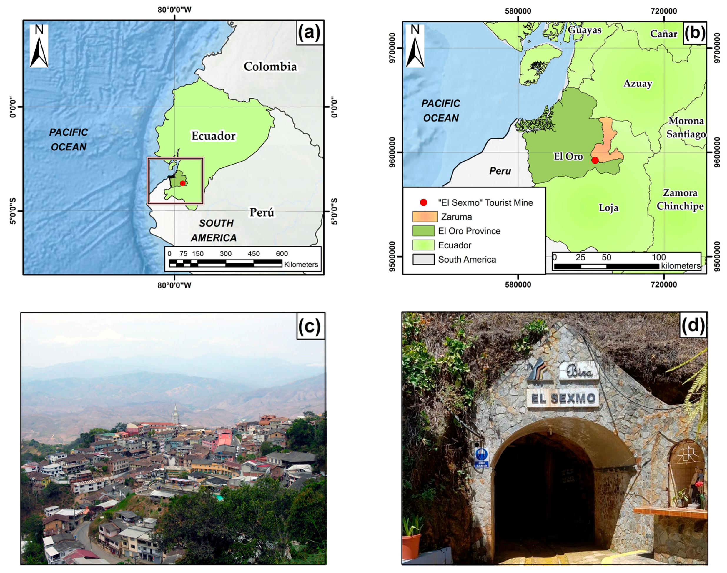
1.1. Study Zone
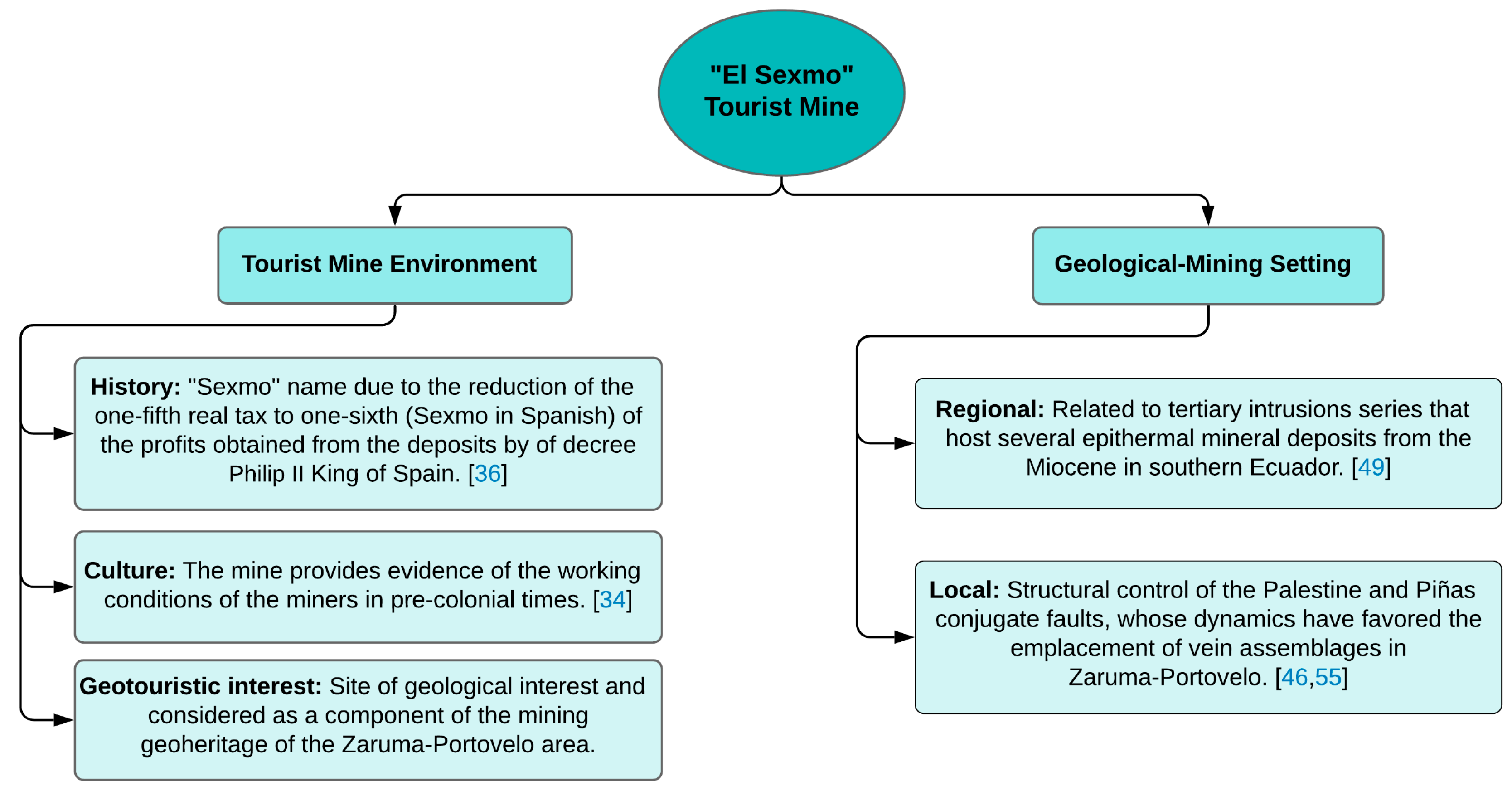
1.2. “El Sexmo” Tourist Mine History
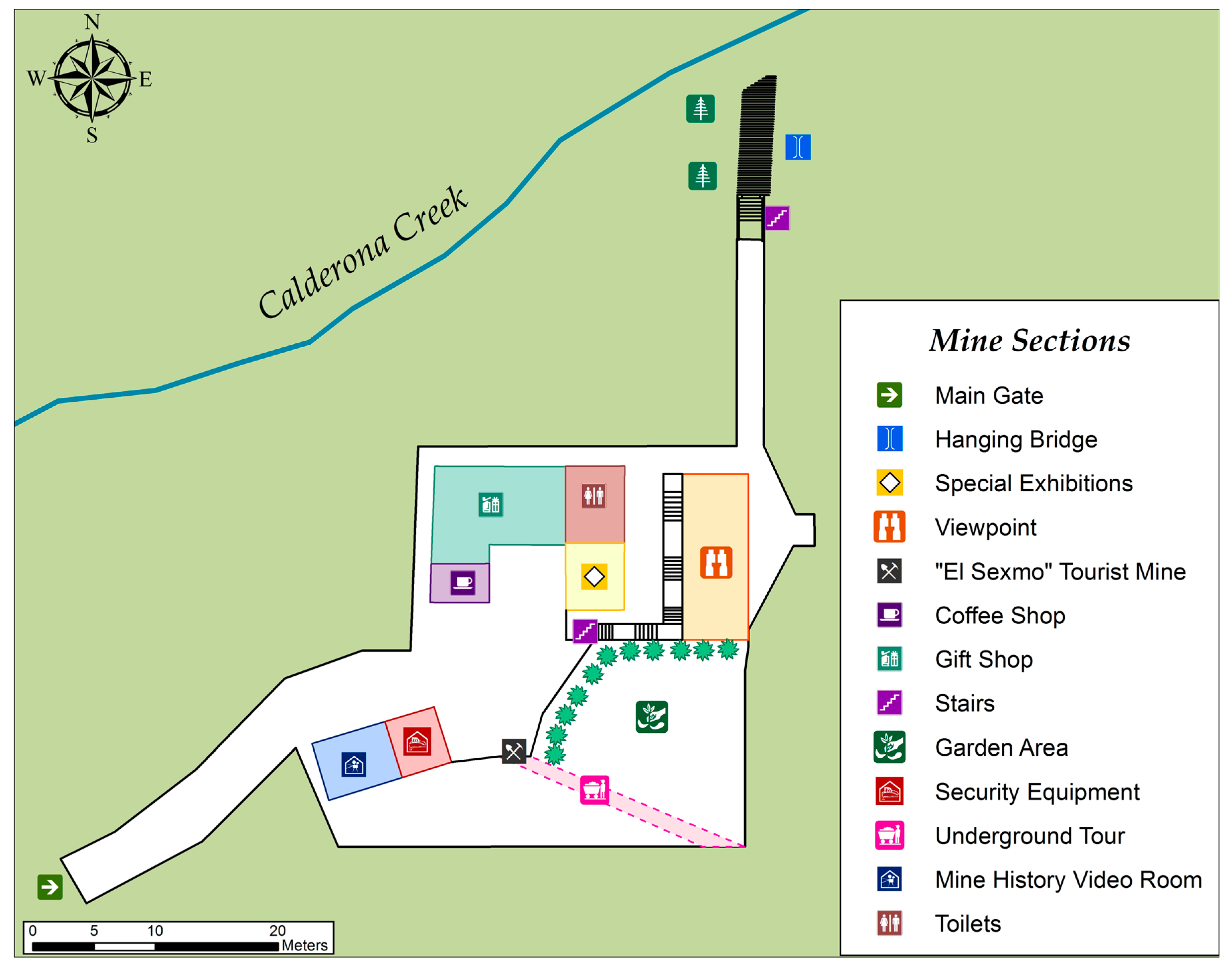
1.3. “El Sexmo” Tourist Mine Services Offered to Visitors
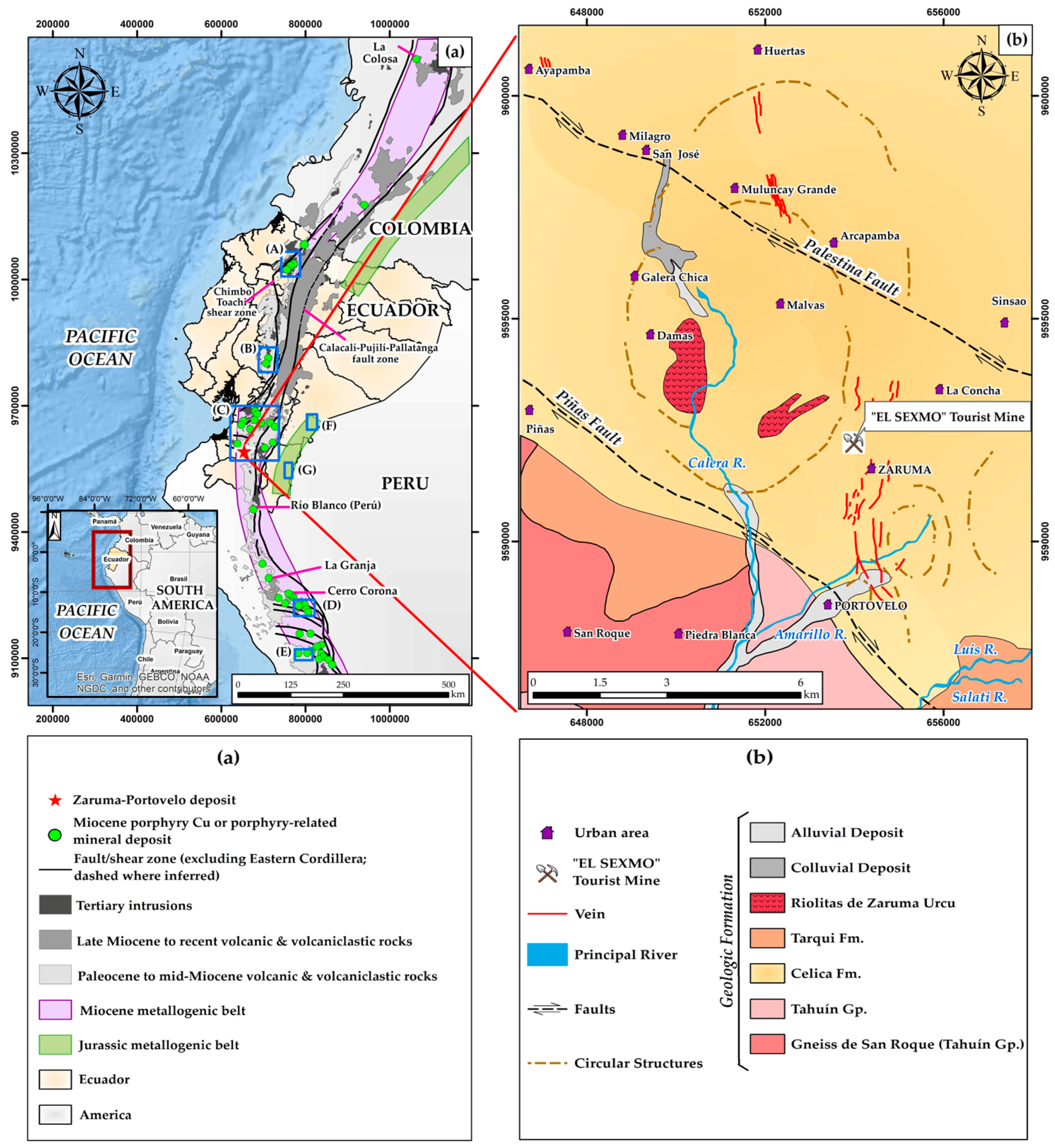
2. Geological Setting
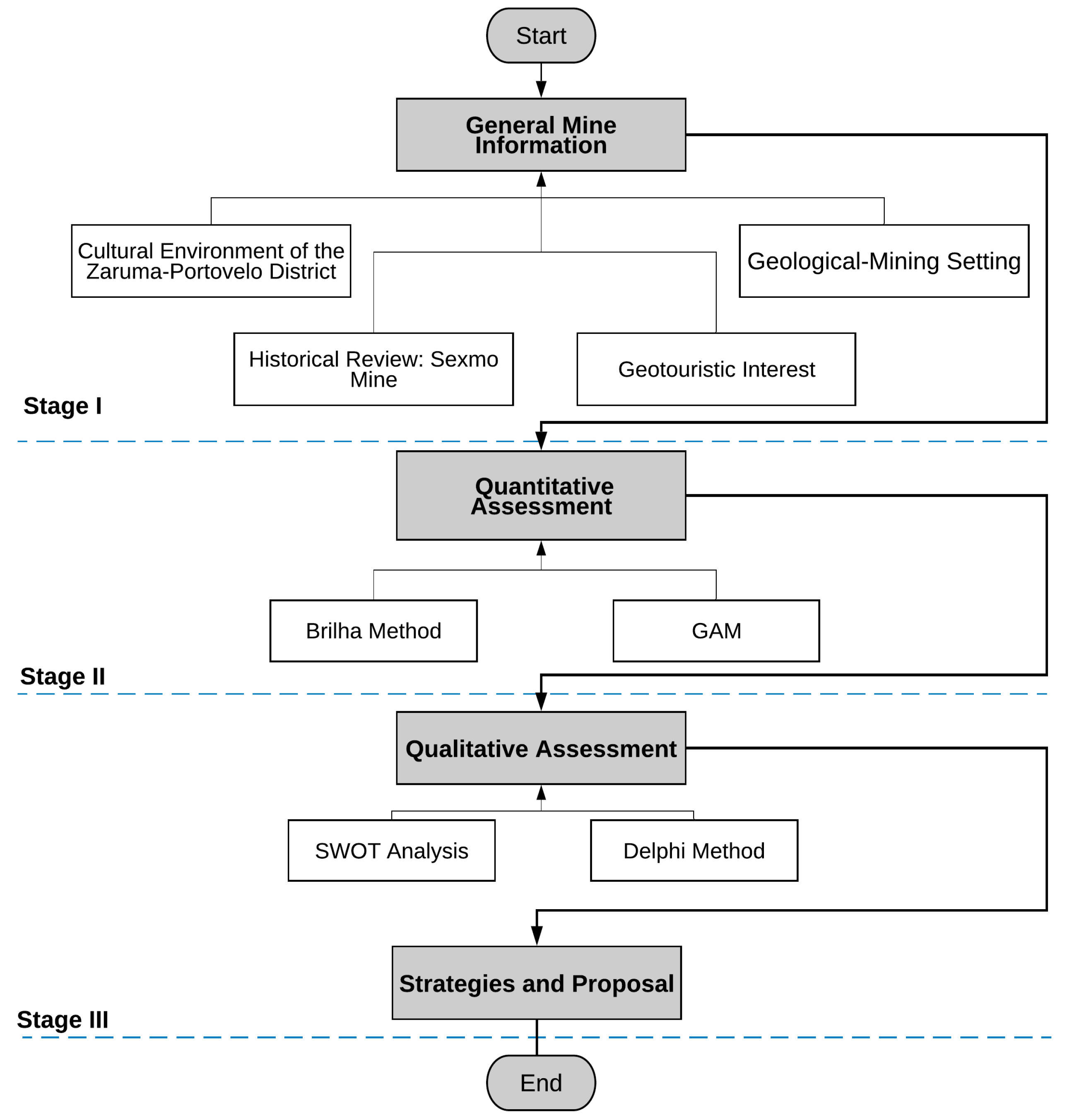
3. Methodology
3.1. First Stage: General Mine Information
3.2. Second Stage: Quantitative Assessment
3.2.1. The Geosite Assessment Model (GAM)
3.2.2. The Brilha Method
3.3. Third Stage: Qualitative Assessment
4. Results
4.1. General Mine Information
4.2. Quantitative Assessment: GAM and Brilha
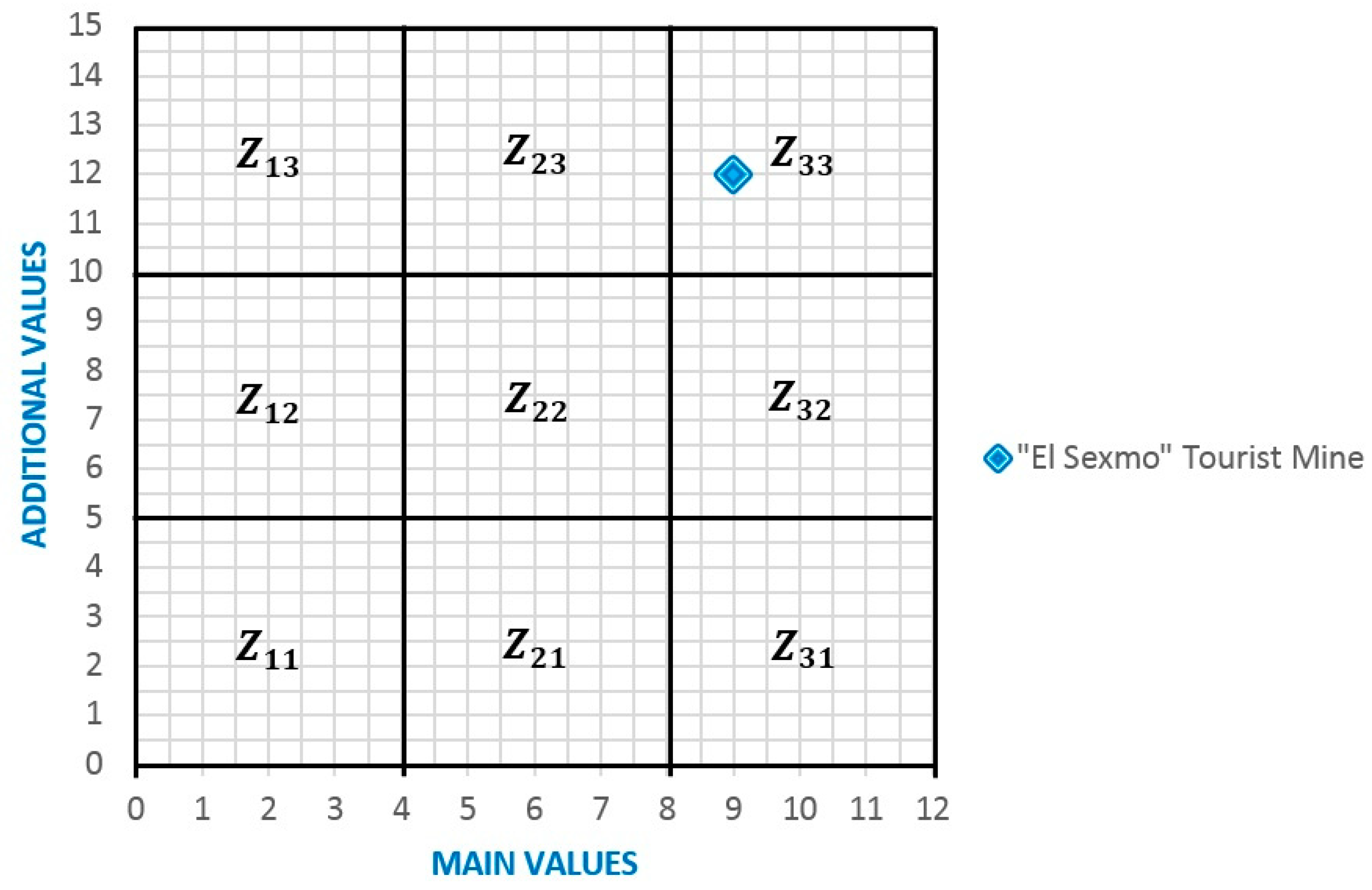
4.2.1. GAM Results
4.2.2. The Brilha Method Results
4.3. The Delphi Method Results
4.4. The SWOT Matrix
4.5. Initiatives and Proposals
- The official presentation of the evaluation work of the “El Sexmo” Tourist Mine as a site with potential for local authorities (Zaruma City Council) for the achievement of official recognition as a UNESCO Global Geopark. In addition, the strategies derived from the SWOT analysis will be delivered in detail as a reference for developing initiatives to take advantage of this important resource.
- The definition of complementary activities to those currently offered at the “El Sexmo” Tourist Mine. Specifically, the creation of a gold-panning zone in the facilities, creation of informative panels of the geological and mining interest of the mine and the locality, and the organization of periodical visits of students from schools and colleges. A general estimate of the increase in the average tourist visit duration time, with the materialization of the proposals described above, would reach 100% (from one and a half to three hours).
- The development of a detailed inventory and evaluation proposal of other locations with potential to be considered as geosites (e.g., Cerro de Arcos) and mining sites (e.g., Magner Turner Mineralogical Museum) in the Zaruma and Portovelo municipalities [15]. A general estimate of the increase in the average tourist view visit duration in the area, with the inclusion of two additional points of interest would mean having a visit offered for one full day.
- Scientific support for the initiative to create a geopark that would be called “Ruta del Oro” (Gold Route) that has its starting point at the “El Sexmo” Tourist Mine, which also includes 27 sites of geological and mining interest in its proposal. This initiative would be based on previous studies that already addressed this possibility (e.g., [15,64]). This initiative would mean being able to offer a broader visit to achieve at least a couple of days’ worth of visitation possibilities, with the corresponding economic benefit for the involved stakeholders.
5. Interpretation of Results and Discussion
6. Conclusions
Supplementary Materials
Author Contributions
Funding
Acknowledgments
Conflicts of Interest
References
- Mert, Y. Contribution to sustainable development: Re-development of post-mining brownfields. J. Clean. Prod. 2019, 240, 118212. [Google Scholar] [CrossRef]
- Cao, X. Regulating mine land reclamation in developing countries: The case of China. Land Use Policy 2007, 24, 472–483. [Google Scholar] [CrossRef]
- Kuter, N. Ulusal Mermer ve Taş¸ Onarım Teknikleri Sempozyumu, Isparta. Terk Edilmiş Açık Ocak Maden Sahalarında Doğaya Yeniden Kazandırma Çalışmaları. 2014, pp. 354–367. Available online: http://ormanweb.isparta.edu.tr/mermerteknik/belgeler/BildirilerKitabi_v2.pdf (accessed on 3 March 2020).
- Mancini, L.; Sala, S. Social impact assessment in the mining sector: Review and comparison of indicators frameworks. Resour. Policy 2018, 57, 98–111. [Google Scholar] [CrossRef]
- Orman ve Su işleri Bakanlığı. Maden SAhaları Rehabilitasyon Eylem Planı 2014–2018; OSİB: Ankara, Turkey, 2014. [Google Scholar]
- Belediyesi, Selçuklu. Selçuklu Kanyon Park 2007. Available online: http://www.selcuklu.bel.tr/ilcemiz/detay/305/selcuklu-kanyon-park.html (accessed on 23 March 2019).
- Garofano, M.; Govoni, D. Underground geotourism: A historic and economic overview of show caves and show mines in Italy. Geoheritage 2012, 4, 79–92. [Google Scholar] [CrossRef]
- Williams, P. World heritage caves and karst. IUCN Gland 2008, 57. Available online: https://portals.iucn.org/library/sites/library/files/documents/2008-037.pdf (accessed on 23 March 2019).
- Zięba, K. Reales minas de sal de Wieliczka y Bochnia: Museo subterráneo, pero aún una mina. Rev. Del Patrim. Mund. 2017, 84, 44–47. [Google Scholar]
- Saltmine, Wieliczka. ”Wieliczka” Salt Mine 2017. Available online: http://www.wieliczka-saltmine.com/ (accessed on 4 July 2019).
- Cai, Y.; Wu, F.; Han, J.; Chu, H. Geoheritage and Sustainable Development in Yimengshan Geopark. Geoheritage 2019, 11, 991–1003. [Google Scholar] [CrossRef]
- Mata-Perelló, J.; Carrión, P.; Molina, J.; Villas-Boas, R. Geomining Heritage as a Tool to Promote the Social Development of Rural Communities. In Geoheritage: Assessment, Protection and Management; Reynard, E., Brilha, J., Eds.; Elsevier: Amsterdam, The Netherlands, 2017; pp. 167–177. [Google Scholar] [CrossRef]
- Brilha, J. Inventory and quantitative assessment of geosites and geodiversity sites: A review. Geoheritage 2016, 8, 119–134. [Google Scholar] [CrossRef]
- Brilha, J. Geoheritage and geoparks. In Geoheritage. Assessment, Protection, and Management; Brilha, J., Ed.; Elsevier: Amsterdam, The Netherlands, 2018; pp. 323–335. [Google Scholar] [CrossRef]
- Carrión Mero, P.; Herrera Franco, G.; Briones, J.; Caldevilla, P.; Domínguez-Cuesta, M.; Berrezueta, E. Geotourism and local development based on geological and mining sites utilization, Zaruma-Portovelo, Ecuador. Geosciences 2018, 8, 205. [Google Scholar] [CrossRef]
- Sánchez-Cortez, J.L. Conservation of geoheritage in Ecuador: Situation and perspectives. Int. J. Geoherit. Parks 2019, 7, 91–101. [Google Scholar] [CrossRef]
- Herrera, G.; Carrión, P.; Briones, J. Geotourism potencial in the context of the geopark project for the development of Santa Elena province, Ecuador. Wit Trans. Ecol. Environ. 2018, 217, 557–568. [Google Scholar]
- Jaramillo, J.P.; García, T.; Bolaños, M. Bosque Petrificado de Puyango y sus alrededores: Inventario de lugares de interés geológico. Rev. Científica Geolatitud 2017, 1, 18. [Google Scholar]
- García-Cortés, A.; Carcavilla, L.; Díaz-Martínez, E.; Vegas, J. Inventario de Lugares de Interés Geológico de la Cordillera Ibérica. 2012. Available online: http://www.igme.es/patrimonio/Informe%20Ib%C3%A9rica%20Final.pdf (accessed on 5 July 2019).
- Pereira, P.; Pereira, D.I.; Alves, M.I. Geomorphosite assessment in Montesinho natural park (Portugal). Geogr. Helv. 2007, 62, 159–168. [Google Scholar] [CrossRef]
- Reynard, E.; Fontana, G.; Kozlik, L.; Scapozza, C. A method for assessing the scientific and additional values of geomorphosites. Geogr. Helv. 2007, 62, 148–158. [Google Scholar] [CrossRef]
- Erhartič, B. Geomorphosite assessment. Acta Geogr. Slov. 2010, 50, 295–319. [Google Scholar] [CrossRef]
- Feuillet, T.; Sourp, E. Geomorphological heritage of the Pyrenees National Park (France): Assessment, clustering, and promotion of geomorphosites. Geoheritage 2011, 3, 151–162. [Google Scholar] [CrossRef]
- Kubalíková, L. Geomorphosite assessment for geotourism purposes. Czech J. Tour. 2013, 2, 80–104. [Google Scholar] [CrossRef]
- Dmytrowski, P.; Kicinska, A. Waloryzacja geoturystyczna obiektów przyrody nieożywionej i jej znaczenie w perspektywie rozwoju geoparków. Probl. Ekol. Kraj. 2011, 29, 11–20. [Google Scholar]
- Vujičić, M.D.; Vasiljević, D.A.; Marković, S.B.; Hose, T.A.; Lukić, T.; Hadžić, O.; Janićević, S. Preliminary geosite assessment model (GAM) and its application on Fruška Gora Mountain, potential geotourism destination of Serbia. Acta Geogr. Slov. 2011, 51, 361–376. [Google Scholar] [CrossRef]
- Petrović, M.; Vasiljević, D.; Vujičić, M.; Hose, T.; Marković, S.; Lukić, T. Geoparque global y análisis candidato-comparativo del geoparque de la montaña Papuk (Croacia) y la montaña Fruška Gora (Serbia) utilizando el modelo GAM. Carpathian J. Earth Environ. Sci. 2013, 8, 105–116. [Google Scholar]
- Álvarez-Jurado, Á. El papel del patrimonio geológico en la gestión de espacios naturales protegidos. Apl. Sierra Mágina 2018, 35–43. Available online: http://tauja.ujaen.es/jspui/handle/10953.1/6431 (accessed on 20 March 2019).
- Culturaypatrimonio. Available online: http://picultural.culturaypatrimonio.gob.ec/ (accessed on 20 March 2019).
- UNESCO World Heritage Centre. Available online: http://whc.unesco.org/en/tentativelists/6089 (accessed on 18 March 2019).
- Spencer, R.M.; Montenegro, J.L.; Gaibor, A.; Perez, E.P.; Mantilla, G.; Viera, F.; Spencer, C.E. The Portovelo-Zaruma mining camp, SW Ecuador: Porphyry and epithermal environments. Seg Newsl. 2002, 49, 8–14. [Google Scholar]
- Herrera, G.; Carrión, P.; Jimenez, S.; Mina, A. Oportunidades para el turismo de patrimonio geológico y minero a partir de modificaciones recientes al marco legal en el Ecuador, El caso de la mina El Sexmo. In Patrimonio Minero y Sustentabilidad: Propuestas y Experiencias de Reutilización; López, M., Pérez, L., Eds.; Ediciones Universidad del Bío-Bío-CYTED: Concepción, Chile, 2014; pp. 167–177. [Google Scholar]
- Vangsnes, G.F. The meanings of mining: A perspective on the regulation of artisanal andsmall-scale gold mining in southern Ecuador. Extr. Ind. Soc. 2018, 5, 317–326. [Google Scholar]
- Carrión, P.; Ladines, L.; Morante, F.; Blanco, R.A. Diagnóstico de la situación geomecánica y de contaminación de Zaruma y Portovelo (Ecuador). In Actas del IV Congreso Internacional Sobre Patrimonio Geológico y Minero; Sedpgym, V.S., Ed.; Aragón, España, 2003; pp. 283–295. Available online: http://www.sedpgym.es/18-publicaciones/actas-congresos/78-actas-del-iv-congreso-internacional-sobre-patrimonio-geologico-y-minero-teruel-2004 (accessed on 20 March 2019).
- Barrantes, C. Reservas Probadas de Mineral y su Valor in Situ; CIMA: Portovelo, Ecuador, 1977. [Google Scholar]
- Murillo, R. ZARUMA, Historia Minera. Identidad en Portovelo; ABYA-YALA: Quito, Ecuador, 2000; Volume 1. [Google Scholar]
- Poma, V. Historia Orense: Documentos de Zaruma; P&C DOS MIL 3: Machala, Ecuador, 1992; Available online: https://issuu.com/historiografiaorense/docs/documentos_de_zaruma (accessed on 20 March 2019).
- Levillier, R. Gobernantes del Perú: Cartas y Papeles: Siglo XVI; Sucesores de Rivadeneira (S.A.): Madrid, España, 1921. [Google Scholar]
- Ramón, G. Loja y Zaruma: Entre las minas y las mulas, 1557–1700. Rev. Ecuat. Hist. Económica 1990, 7, 111–143. [Google Scholar]
- Lane, K. Unlucky strike: Gold and labor in Zaruma, Ecuador, 1699–1820. Colonial Lat. Am. Rev. 2004, 13, 65–84. [Google Scholar] [CrossRef]
- Rengel, J. Desarrollo Nacional de la Minería Ecuatoriana; Escuela Superior Politécnica del Litoral: Guayaquil, Ecuador, 1985. [Google Scholar]
- Bonilla, W. Metalogenia del Distrito minero Zaruma-Portovelo, República del Ecuador. Ph.D. Thesis, Universidad de Buenos Aires, Buenos Aires, Argentina, 2009. [Google Scholar]
- Astudillo, C. El Sudor del Sol: Historia de la Minería Orense; LaTierra, Ed.; Corporación de Ediciones la Tierra: Quito, Ecuador, 2007. [Google Scholar]
- Velásquez-López, P.C.; Veiga, M.M.; Hall, K. Mercury balance in amalgamation in artisanal and small-scale gold mining: Identifying strategies for reducing environmental pollution in Portovelo-Zaruma, Ecuador. J. Clean. Prod. 2010, 18, 226–232. [Google Scholar] [CrossRef]
- Sandoval, F. Small-scale mining in Ecuador. Environ. Soc. Found. 2001, 75. Available online: https://pubs.iied.org/pdfs/G00720.pdf (accessed on 20 March 2019).
- Van Thournout, F.; Salemink, J.; Valenzuela, G.; Merlyn, M.; Boven, A.; Muchez, P. Portovelo: A volcanic-hosted epithermal vein-system in Ecuador, South America. Miner. Depos. 1996, 31, 269–276. [Google Scholar] [CrossRef]
- Meyer, C.; Hemley, J.J. Wall rock alterations, 166–235. In Geochemistry of Hydrothermal ore Deposits (HG Barnes, ed.); Winston Inc.: New York, NY, USA, 1967; p. 670. [Google Scholar]
- Heald, P.; Foley, N.K.; Hayba, D.O. Comparative anatomy of volcanic-hosted epithermal deposits; acid-sulfate and adularia-sericite types. Econ. Geol. 1987, 82, 1–26. [Google Scholar] [CrossRef]
- Schütte, P.; Chiaradia, M.; Barra, F.; Villagómez, D.; Beate, B. Metallogenic features of Miocene porphyry Cu and porphyry-related mineral deposits in Ecuador revealed by Re-Os, 40 Ar/39 Ar, and U-Pb geochronology. Miner. Depos. 2012, 47, 383–410. [Google Scholar] [CrossRef]
- Schütte, P.; Chiaradia, M.; Beate, B. Petrogenetic evolution of arc magmatism associated with Late Oligocene to Late Miocene porphyry-related ore deposits in Ecuador. Econ. Geol. 2010, 105, 1243–1270. [Google Scholar] [CrossRef]
- PRODEMINCA. Depósitos epitermales en la Cordillera Andina. In Evaluación de Distritos Mineros del Ecuador; UCP PRODEMINCA Proyecto MEM BIRF: Quito, Ecuador, 2000; Volume 2, pp. 36–55. [Google Scholar]
- PRODEMINCA. Depósitos porfídicos y epi-mesotermales relacionados con intrusiones de las Cordilleras Occidental y Real. In Evaluación de Distritos Mineros del Ecuador; UCP PRODEMINCA Proyecto MEM BIRF: Quito, Ecuador, 2000; Volume 4, pp. 36–55. [Google Scholar]
- Aspden, J.A.; Bonilla, W.; Duque, P. The El Oro Metamorphic Complex, Ecuador: Geology and Economic Mineral Deposits; British Geological Survey: Nottingham, UK, 1995. [CrossRef]
- Riel, N.; Martelat, J.E.; Guillot, S.; Jaillard, E.; Monié, P.; Yuquilema, J.; Mercier, J. Fore arc tectonothermal evolution of the El Oro metamorphic province (Ecuador) during the Mesozoic. Tectonics 2014, 33, 1989–2012. [Google Scholar]
- Berrezueta, E.; Ordóñez-Casado, B.; Bonilla, W.; Banda, R.; Castroviejo, R.; Carrión, P.; Puglla, S. Ore petrography using optical image analysis: Application to Zaruma-Portovelo deposit (Ecuador). Geosciences 2016, 6, 30. [Google Scholar] [CrossRef]
- Paladines, A.P.; Rosero, G. Zonificación Mineralogénica del Ecuador; Laser Editores S.A.: Quito, Ecuador, 1996. [Google Scholar]
- Vikentyev, I.; Banda, R.; Tsepin, A.; Prokofiev, V.; Vikentyeva, O. Mineralogy and formation conditions of Portovelo-Zaruma gold-sulphide vein deposit, Ecuador. Geochem. Mineral. Petrol. 2005, 43, 148–154. [Google Scholar]
- Chiaradia, M.; Fontboté, L.; Beate, B. Cenozoic continental arc magmatism and associated mineralization in Ecuador. Miner. Depos. 2004, 39, 204–222. [Google Scholar] [CrossRef]
- La Misión Británica y la Dirección General de Geología y Minas. Hoja Geológica Zaruma 38 CT-NVI-E escala 1:100,000; Instituto de Investigación Geológico y Energético, Ministerio de Recursos Naturales y Energéticos, Dirección General de Geología y Minas: Quito, Ecuador, 1980. [Google Scholar]
- McKenna, H.P. he Delphi technique: A worthwhile research approach for nursing? J. Adv. Nurs. 1994, 19, 1221–1225. [Google Scholar] [CrossRef] [PubMed]
- Hasson, F.; Keeney, S. Enhancing rigour in the Delphi technique research. Technol. Forecast. Soc. Chang. 2011, 78, 1695–1704. [Google Scholar] [CrossRef]
- Dyson, R.G. Strategic development and SWOT analysis at the University of Warwick. Eur. J. Oper. Res. 2004, 152, 631–640. [Google Scholar] [CrossRef]
- INEC. Instituto Nacional de Estadística y Censos 2010. Available online: https://www.ecuadorencifras.gob.ec/censo-de-poblacion-y-vivienda/ (accessed on 1 January 2020).
- Berrezueta, E.; Domínguez-Cuesta, M.J.; Carrión, P.; Berrezueta, T.; Herrero, G. Propuesta metodológica para el aprovechamiento del patrimonio geológico minero de la zona Zaruma-Portovelo (Ecuador). Trab. Geol. 2006, 26, 103–109. [Google Scholar]


| Geosite Assessment Model (GAM) | |||
|---|---|---|---|
| Indicators/Subindicators | Indicators/Subindicators | ||
| Main Values | Scientific/Educational values (VSE) | Additional Values | Functional values (VFn) |
| 1. Rarity 2. Representativeness 3. Knowledge on geo-scientific issues 4. Level of interpretation | 1. Accessibility 2. Additional natural values 3. Additional anthropogenic values 4. Vicinity of emissive centres 5. Vicinity of important road networks 6. Additional functional values | ||
| Scenic/Aesthetic values (VSA) | Touristic values (VTr) | ||
| 1. Viewpoints 2. Surface 3. Surrounding landscape and nature 4. Environmental fitting of sites | 1. Promotion 2. Organized visits 3. Vicinity of the visitors’ center 4. Interpretative panels 5. Number of visitors 6. Tourism infrastructure 7. Tour guide service 8. Hostel service 9. Restaurant service | ||
| Protection values (VPr) | |||
| 1. Current condition 2. Protection level 3. Vulnerability 4. Suitable number of visitors | |||
| Brilha Method | ||||
|---|---|---|---|---|
| Indicators/Subindicators | Values | Weight | ||
| Scientific Value (SV) | ||||
| A. Representativeness | 1–4 | 30 | ||
| B. Key locality | 20 | |||
| C. Scientific knowledge | 5 | |||
| D. Integrity | 15 | |||
| E. Geological diversity | 5 | |||
| F. Rarity | 15 | |||
| G. Use limitations | 10 | |||
| Total | 100 | |||
| Use Educational Potential (UEP) and Potential Tourism Use (PTU) | Values | Weight | ||
| UEP | PTU | 1–4 | UEP | PTU |
| A. Vulnerability B. Accessibility C. Use limitations D. Safety E. Logistics F. Density of population G. Association with other values H. Scenery I. Uniqueness J. Observation conditions K. Didactic potential L. Geological diversity | 10 | 10 | ||
| 10 | 10 | |||
| 5 | 5 | |||
| 10 | 10 | |||
| 5 | 5 | |||
| 5 | 5 | |||
| 5 | 5 | |||
| 5 | 15 | |||
| 5 | 10 | |||
| 10 | 5 | |||
| K. Interpretative potential L. Economic level M. Proximity of recreational areas | 20 | 10 | ||
| 10 | 5 | |||
| 5 | ||||
| Total | 100 | 100 | ||
| Degradation Risk (DR) | Values | Weight | ||
| A. Deterioration of geological elements | 1–4 | 35 | ||
| B. Proximity to areas/activities with potential to cause degradation | 20 | |||
| C. Legal protection | 100 | |||
| D. Accessibility | 15 | |||
| E. Density of population | 10 | |||
| Total | 100 | |||
| Total Weight | Degradation Risk |
|---|---|
| <200 | Low |
| 201–300 | Moderate |
| 301–400 | High |
| Values | Indicators/Subindicators | Description |
|---|---|---|
| Scientific Value | Representativeness | The mine is a symbol of artisanal mining identity of Zaruma city, recognized as the first mine of the area. It has unique geological characteristics, highlighting the rosary-style veins belonging to part of a regional vein system: Nicole, Gaby, and Octubrina, of hydrothermal origin with a predominance of sulphides and the presence of gold, belonging to the Zaruma–Portovelo intermediate sulphuration deposit. Its average orientation is N-S, associated with the trend of regional fracture of the NW–SE direction (Palestina and Piñas Fault). It is also possible to visualize the city and its unique geomorphological landscape with very steep slopes. |
| Geological diversity | It has a high scientific interest; the mineralogical aspect stands out as the primary geological interest, whereas the intrusive, geomorphological, hydrological, petrological, tectonic, landscape, and artisanal exploitation techniques are secondary interests. | |
| Key locality | The site of geological interest is a good example of mineralization in the south of the country, near the mine is the trend of mineralization formed by the structural dynamics of the Piñas and Palestine faults, which have favored the formation of dilating spaces for the location of vein assemblages with gold content. | |
| Scientific knowledge | There are studies by universities that have been published in national and international impact journals under different themes (geological, economic, tourism, and cultural). | |
| Integrity | The good state of conservation of the site allows us to visualize the veins present with mineralization; at the beginning of the tour (“bocamina”), the mine presents stabilization with concrete and drains, which prevent detachment by water and fracture action in the massif. | |
| Rarity | The regional mineralogical environment is identified as epi-mesothermal; however, in the study area, the minerals present indicate a uniquely epithermal environment. The site of geological interest is the only one recognized as a founder of artisanal mining in Ecuador. This mine has characteristics of the development of artisanal mining in the precolonial times, as well as stories of Spanish mining. | |
| Use limitations | The mine allows studies of scientific interest after requesting the necessary permits. It is a site of geotouristic interest that collaborates and maintains a relationship with the scientific community. | |
| Potential Educational and Touristic Uses | Vulnerability | The site is in proximity to areas with illegal mining, an anthropic activity that has caused subsidence events in Zaruma, such as the sinking of the “La Inmaculada Fe y Alegría” school and surrounding houses. |
| Accessibility | The site is located less than 900 m from a Zaruma urban center by paved road (Estimated duration: 3 min per car and 15 min on foot). | |
| Use limitations | The mine tour is free (no need to pay an entrance fee); operating hours: Monday–Sunday (8:00 to 16:00), and the site has no limitations for use by students and tourists. | |
| Safety | The site provides personal protective equipment such as a helmet and rubber boots for underground tours; the mine entrance is reinforced concrete and is drained to ensure its stability. Additionally, there is an account mobile phone coverage, and the mine is located less than 1.5 km from emergency services. | |
| Logistics | Lodging and restaurants for groups of 50 persons are less than 15 km away from the site. | |
| Density of population | The site is located in a municipality with 37.14 inhabitants/km² [63]. | |
| Association with other values | An illustrative example of the cultural heritage of Zaruma town is the “El Sexmo” Tourist Mine; the site reflects mining activity carried out in precolonial times, and it is the oldest mine in Ecuador. The mine is named after the king, due to the historic event of a reduction of the fifth real tax by one-sixth by decree of Philip II King of Spain in gratitude for the discovery of "pepa de oro" (gold nugget), whose weight was more than three pounds. In addition, the site shows the good side of mining as one of the initiatives of reclamation in a post-mining environmentally friendly and sustainable way. | |
| Scenery | The site is currently used as a tourism destination in national campaigns such as field visits by universities (e.g., ESPOL Polytechnic University) by students of mining and geology engineering, in addition to visits organized by groups of students from local secondary and elementary schools. | |
| Uniqueness | The site shows unique and uncommon features in Ecuador due to the mine being an artisanal and small-scale gold mining example that keeps aspects of the cultural heritage of the mining area. | |
| Observation conditions | All geological elements are observed to be in good condition. | |
| Didactic potential | After the mine history video, visitors navigate inside a 500 m long underground tunnel on slippery ground along the railway that hauled tons of ore out of the mine, wearing equipment used by geologists and miners, attempting to understand the difficult work of miners (artisanal and small-scale gold mining in SW Ecuador) as they learn about the mining history of the area, objects related to former mining activities, and the geological context of hydrothermal alterations in one type of rock (igneous rock). The information can be easily understood by students with different educational levels. | |
| Geological diversity | The site has more than three types of geodiverse elements that occur in the site (mining, intrusive, geomorphological, hydrological, petrological, tectonic, landscape, and artisanal exploitation techniques). | |
| Interpretative potential | The site presents artisanal and small-scale gold mining elements in a very clear and expressive way to all members of the public. | |
| Economic level | The average of the Zaruma Canton of unsatisfied basic needs (NBI) referring to the poor population is 75.9% and that of the nonpoor population 24.1%. In other words, nine out of 10 parishes have a poor population in excess of 60%, and one parish in a nonpoor population exceeds 60% [63]. | |
| Proximity of recreational areas | The site is located less than 5 km from recreational areas and tourist attractions (Zaruma Center Historic, Zaruma Municipal Museum, Shrine of the Virgen del Carmen, Zaruma Urcu hill, Calvario hill, a coffee shop, and Zaruma’s traditional meals). | |
| Degradation Risk (DR) | Deterioration of geological elements | There is a possibility of deterioration of secondary geological elements. |
| Proximity to areas/activities with potential to cause degradation | The site is located less than 1 km from a potential degrading area/activity. | |
| Legal protection | The mine lacks legal support, which ensures sustainability and validity, but it is located within a new area of exclusion of mining activity delimited under the urban area of the city of Zaruma according to the Ministerial Agreement 2019–0050-AM. | |
| Scenic/Aesthetic values | Viewpoints | The mine has a main gate with a sign displaying its name that can be seen from at least two vantage points. |
| Surface | The underground tunnel is 500 m long, and the surface zone of the mine (mine history video room, gift shop, hanging bridge, viewpoint, and coffee shop) has an approximate area of 1300 m2. | |
| Surrounding landscape and nature | Tourists can enjoy a spectacular view of the valley below and of the surrounding mountains. | |
| Environmental fitting of sites | The site fits perfectly with the natural environment of the study area. |
| Geosite Assessment Model (GAM) | |||||
|---|---|---|---|---|---|
| Values | Indicators/Subindicators | Score | Values | Indicators/Subindicators | Score |
| MAIN VALUES | Scientific/Educational values (VSE) | Functional values (VFn) | |||
| 1. Rarity | 0.5 | ADDITIONAL VALUES | 1. Accessibility | 1 | |
| 2. Representativeness | 0.75 | 2. Additional natural values | 1 | ||
| 3. Knowledge on geoscientific issues | 1 | 3. Additional anthropogenic values | 1 | ||
| 4. Level of interpretation | 0.75 | 4. Vicinity of emissive centres | 1 | ||
| (VSE) Total | 3.00 | 5. Vicinity of important road network | 0.75 | ||
| 6. Additional functional values | 1 | ||||
| Scenic/Aesthetic values (VSA) | (VFn) Total | 5.75 | |||
| 1. Viewpoints | 0.5 | Touristic values (VTr) | |||
| 2. Surface | 0 | 1. Promotion | 1 | ||
| 3. Surrounding landscape and nature | 1 | 2. Organized visits | 0.75 | ||
| 4. Environmental fitting of sites | 1 | 3. Vicinity of the visitors’ center | 0.25 | ||
| (VSA) Total | 2.5 | 4. Interpretative panels | 0.5 | ||
| Protection (VPr) | 5. Number of visitors | 0.5 | |||
| 1. Current condition | 1 | 6. Tourism infrastructure | 0.75 | ||
| 2. Protection level | 1 | 7. Tour guide serve | 0.75 | ||
| 3. Vulnerability | 0.5 | 8. Hostel service | 1 | ||
| 4. Suitable number of visitors | 1 | 9. Restaurant service | 0.75 | ||
| (VPr) Total | 3.5 | (VTr) Total | 6.25 | ||
| Brilha Method | ||||
|---|---|---|---|---|
| Indicators/Subindicators | Values | Weight | ||
| Scientific Value (SV) | ||||
| A. Representativeness B. Key locality C. Scientific knowledge D. Integrity E. Geological diversity F. Rarity G. Use limitations Total | 4 2 4 4 4 4 2 | 120 40 20 60 20 60 10 340 | ||
| Potential Educational and Touristic Uses | Values | Weight | ||
| UEP | PTU | 3 3 4 4 4 1 4 4 3 4 4 4 4 1 4 | UEP | PTU |
| A. Vulnerability B. Accessibility C. Use limitations D. Safety E. Logistics F. Density of population G. Association with other values H. Scenery I. Uniqueness J. Observation conditions K. Didactic potential L. Geological diversity | 30 | 30 | ||
| 30 | 30 | |||
| 20 | 20 | |||
| 40 | 40 | |||
| 20 | 20 | |||
| 5 | 5 | |||
| 20 | 20 | |||
| 20 | 60 | |||
| 15 | 30 | |||
| 40 | 20 | |||
| K. Interpretative potential L. Economic level M. Proximity of recreational areas | 80 | 40 | ||
| 40 | 5 | |||
| 20 | ||||
| Total | 330 | 340 | ||
| Degradation Risk (DR) | Values | Weight | ||
| A. Deterioration of geological elements B. Proximity to areas/activities with potential to cause degradation C. Legal protection D. Accessibility E. Density of population Total | 2 1 3 4 4 | 70 20 60 60 40 250 | ||
| Internal Environment | Strengths | Weaknesses | |
| External Environment | S1. “El Sexmo” Tourist Mine, a symbol of mining identity. S2. Strategic location. S3. It has a variety of services of a tourist mine such as free underground tours, free surface tours, gift shop, special exhibitions, and a mine history video. S4. Area of geological-mining interest (geosite potential). | W1. The parking service and roads of the geosite and the place are limited. W2. The mine does not present a virtual tour, and there is no official website of the site. W3. There is a lack of a recreational park for children as a learning tool. W4. Limited educational and scientific publications. | |
| Opportunities | Strategies: Strengths + Opportunities | Strategies: Weaknesses + Opportunities | |
| O1. Support the creation of a geopark. O2. Use the mine as an example of environmental awareness projection for cultural and natural conservation through tourism. O3. Invest in basic services and road infrastructure. O4. Exploit the mine as an alternative for the scientific/educational interest, tourism, and economic development of the area. | S1.O1. Bolster the recognition of several geosites in the study area and the creation of a geopark proposal. S1.O2. Boost an innovation project for the mine to be considered an official geosite mining site. S4.O1.O3. Adapt the surrounding conditions for the repowering of the geosite. S3.O1.O4. Promote the “El Sexmo” Tourist Mine as a technical, social, environmental, and cultural example. | W1.O3. Redesign the road infrastructure taking advantage of underground spaces as parking spaces for visitors. W3.O4. Complement the services offered by the mine, implementing spaces that encourage child participation and scientific/educational development. W4.O4. Promote the site (geosite) through informative and scientific publications that involve the scientific–social–business nexus. | |
| Threats | Strategies: Strengths + Threats | Strategies: Weaknesses + Threats | |
| T1. High degradation because it is located near illegal mining activity, which has caused damage to the urban infrastructure. T2. Deterioration due to natural events. T3. The high density of abandoned underground spaces with the possibility of becoming tourist attractions in the study area would cause the mine to lose its uniqueness. T4. It lacks full legal support, which ensures its sustainability and validity. | S1.T1.T4. Protect the tourist mine as an identity of Zaruma in the inventory of the Tourism and Heritage Ministry. S2.T2. Generate studies/stabilization works for the mine due to its natural conditions. S1.T3. Promote a program of innovation strategies that add value to the site. | W1.T3. Take advantage of abandoned underground spaces for parking. W2.T3. Create a web page with virtual visitors to strengthen tourism activity. W4.T1.T2. Develop scientific publications to identify the possible threats to anthropic and natural events. | |
© 2020 by the authors. Licensee MDPI, Basel, Switzerland. This article is an open access article distributed under the terms and conditions of the Creative Commons Attribution (CC BY) license (http://creativecommons.org/licenses/by/4.0/).
Share and Cite
Carrión-Mero, P.; Loor-Oporto, O.; Andrade-Ríos, H.; Herrera-Franco, G.; Morante-Carballo, F.; Jaya-Montalvo, M.; Aguilar-Aguilar, M.; Torres-Peña, K.; Berrezueta, E. Quantitative and Qualitative Assessment of the “El Sexmo” Tourist Gold Mine (Zaruma, Ecuador) as A Geosite and Mining Site. Resources 2020, 9, 28. https://doi.org/10.3390/resources9030028
Carrión-Mero P, Loor-Oporto O, Andrade-Ríos H, Herrera-Franco G, Morante-Carballo F, Jaya-Montalvo M, Aguilar-Aguilar M, Torres-Peña K, Berrezueta E. Quantitative and Qualitative Assessment of the “El Sexmo” Tourist Gold Mine (Zaruma, Ecuador) as A Geosite and Mining Site. Resources. 2020; 9(3):28. https://doi.org/10.3390/resources9030028
Chicago/Turabian StyleCarrión-Mero, Paúl, Oscar Loor-Oporto, Héctor Andrade-Ríos, Gricelda Herrera-Franco, Fernando Morante-Carballo, María Jaya-Montalvo, Maribel Aguilar-Aguilar, Karen Torres-Peña, and Edgar Berrezueta. 2020. "Quantitative and Qualitative Assessment of the “El Sexmo” Tourist Gold Mine (Zaruma, Ecuador) as A Geosite and Mining Site" Resources 9, no. 3: 28. https://doi.org/10.3390/resources9030028
APA StyleCarrión-Mero, P., Loor-Oporto, O., Andrade-Ríos, H., Herrera-Franco, G., Morante-Carballo, F., Jaya-Montalvo, M., Aguilar-Aguilar, M., Torres-Peña, K., & Berrezueta, E. (2020). Quantitative and Qualitative Assessment of the “El Sexmo” Tourist Gold Mine (Zaruma, Ecuador) as A Geosite and Mining Site. Resources, 9(3), 28. https://doi.org/10.3390/resources9030028