1. Introduction
Geotourism can be defined as “the provision of interpretative and service facilities for geosites and geomorphosites and their encompassing topography, together with their associated in situ and ex situ artefacts, to constituency-build for their conservation by generating appreciation, learning and research by and for current and future generations” [
1] (p. 11). It employs an easily and globally accurate translatable vocabulary for the nature, focus and location of modern geology-based geotourism with a geoconservation purpose.
Geotourists can be divided in two groups, “casual” and “dedicated” [
2]. The former occasionally visit geosites and geomorphosites mainly for recreation and pleasure; populist guides, trails and visitor centres have recently been provided for them. The latter intentionally visit geosites for the purpose of personal educational or intellectual improvement and enjoyment; field guides and journal papers are a long-standing provision for them.
The geotourism offer is usually based on geoheritage sites of preeminent scientific value which directly translate into educational opportunities. However, at least from the perspective of tourism industry, the scenic component of geosites is equally important since modern geotourism provision meets geotourists’ needs by attracting them to particular localities with spectacular or readily-appreciated geomorphological features [
3]. This refers particularly to landforms marked by intriguing, unusual or even bizarre shapes that justifies the “devil” name attributed to them by local communities or first explorers. For example, the Times World Atlas reports numerous “devil” landforms such as mountains, hills, gorges, lakes and deserts. Some examples are the Devil’s City, a Serbian area marked out by about 200 earth pillars or the Devil’s Balls, a number of spheroidal boulders occurring at Northern Territories (Australia). However, the most famous devil’s landform in the world is most likely the Devil’s Tower placed in the Wyoming (United States), whose top surface has been the theatre of the first close meeting of mankind with aliens in the Spielberg’s movie “Close Encounters of the Third Kind” of 1997. This spectacular isolated relief of cylindrical shape shows its flat top surface at 1558 m altitude and elevates about 400 m from the surrounding plain. The sub-vertical slopes of this laccolith are marked by a well-developed columnar jointing. This relief is placed inside a natural park which receives about 400,000 visitors each year.
Thanks to their peculiar morphology, “devil” landforms can attract tourists whose interest in Earth history is minimal or non-existent. Then, an opportunity arises to provide more in-depth explanation and interpretation. Thus, it is assumed that telling the story about rocks may be easier at natural rock outcrops rather than in quarries, particularly since in the former case the story would be more comprehensive, involving near-surface processes and landform evolution too. In addition, strange landforms usually give rise to strange stories so that Serbian earth pillars are seen by local people as petrified men or aliens, Australian spheroidal blocks are the Rainbow Snake eggs, and columnar jointing at Devil’s Tower are the scratches produced by the paws of a huge grizzly which tried to catch seven little girls saved by the Great Spirit on the relief flat top surface. For this, devil landforms are generally useful links with the cultural heritage of the area, covering in this way a leading role in the geotourism development of the area. Geotourism, in fact, allows tourists to appreciate local geology but also to better understand its relationship to other assets of the territory, such as biodiversity, archaeological and cultural values [
4]. The geotourism offer should thus include abiotic, biotic and cultural components. These last ones include cultural, spiritual and historic meanings (e.g., folklore, sacred sites and sense of place) [
5].
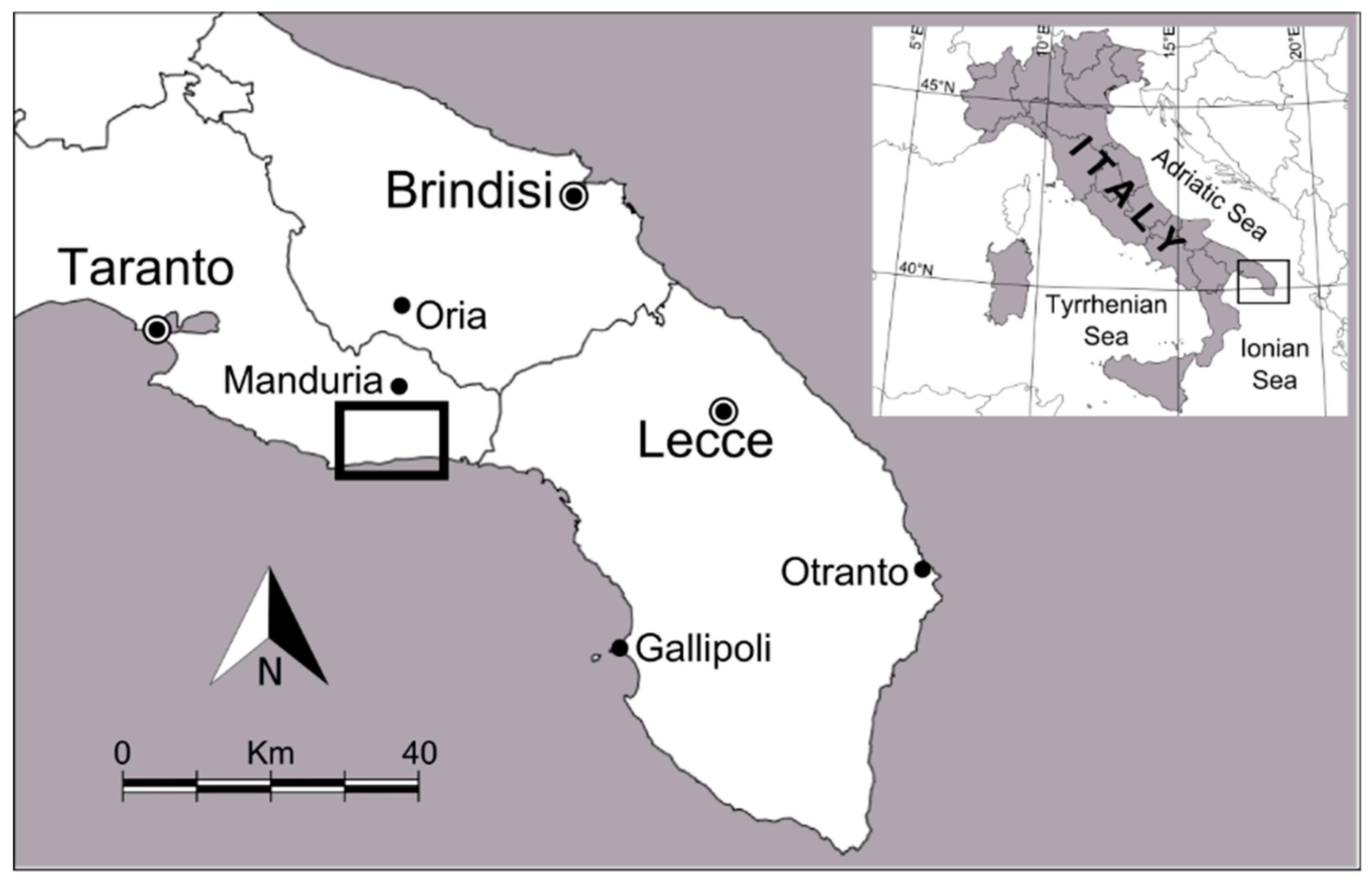
This paper reports the results of the geomorphological analysis carried out in a coastal area of southern Apulia area which is marked by a singular isolated small relief, the
Monte del Diavolo (i.e., the “Devil’s Mount”) (
Figure 1). Research was carried out by means of field survey integrated with interpretation of aerial photos; an accurate bibliographic analysis allowed data collection about geological features and archaeological and cultural heritage of the area as well.
Notwithstanding its morphological peculiarity,
Monte del Diavolo has received little attention from researchers so far [
6] and it has not been enclosed in the sites of the relevant geological interest inventory realized by Regione Puglia Administration [
7]. Nevertheless, the
Monte del Diavolo relief belongs to the history of the geological knowledge development of Apulia region since Earl Michele Milano (1820), in his pioneering paper about the geology of this region [
8], wrongly considered
Monte del Diavolo relief a geological proof of past volcanic activity in southern Apulia. He reported smoke coming from surficial fractures of the small relief as well as some strange lights; moreover, he compared the singular relief near
Manduria village to the homonymous relict volcano placed in the
Verona area and to the
Fossa del Diavolo (i.e., the Devil’s Graben) at
Lipari island, where, according to the local traditions, flames came out from a pothole. A further evidence of
Monte del Diavolo volcanic origin would have been the presence of a sulphurous water spring at the nearby
Li Cuturi wood which dried up in the 1778.
A detailed geomorphological study of the area was carried out aiming to fill up this gap. Collated data are the first step towards the construction of a geotourism offer in this area, which is already a well-known tourism locality.
In addition, the
Monte del Diavolo isolated relief is placed in an area of high archaeological interest (
Li Castelli locality), marked by the remains of a Messapic settlement referred to the period spanning between VIII century to III century B.C. [
9] and includes some regional natural reserves (
Riserva naturale regionale orientata del Litorale Tarantino Orientale) of high ecological value. Finally, it is crossed by several hiking trails and biking routes, which allow its natural heritage to be exploited in a sustainable way.
2. Geotourism in Apulia Region
The Apulia region is among the most visited Italian regions, with more than 15 million visitors recorded in 2018. The local tourism industry is rapidly growing with a tourism presence increase of about 12.2% in the period spanning from 2015 to 2018. Nowadays it represents about 5% of added regional value [
10].
Data collated by Regione Puglia Administration show that domestic tourists prevail (about 80%); they concentrate during summer because of the attractiveness of local beaches, the high quality of coastal waters, and the eno-gastronomic tradition as well. On the other hand, international tourists are more interested in the cultural and natural heritage of the region and their presence is recorded on a wider period of the year spanning from March to October.
The Apulia region shows a rich geological heritage and geodiversity since it comprises foreland–foredeep–chain domains. It has been the focus of the Puglia Regional Lawn, 33/2009 “
Tutela e valorizzazione del patrimonio geologico e speleologico” (Conservation and Promotion of Geological and Speleological Heritage), which promoted the compilation of a regional geosites inventory comprising 440 records [
7] and economic support to a number of measures for their valorisation and protection.
However, the geotourism potential of this region is largely unexploited since an organized geotourism provision is presently restricted to very few spots, like the Castellana Caves (more than 320,000 visitors in the 2018) or Zinzulusa Cave (more than 100,000 visitors per year). Guided field trips for the public, often carried out in the context of national and international events dedicated to geology themes as well as those organized by cultural associations, do not improve significantly the current situation.
3. Geological and Geomorphological Outline of the Area
The
Monte del Diavolo is placed between the
Manduria village (Province of
Taranto) and the coastline (
Figure 2), at the easternmost part of the
Murge Tarantine, one of the five morphological districts recognized in southern Apulia [
11] (
Figure 3), a narrow and flat peninsula stretching between the Ionian and the Adriatic Seas.
The
Murge Tarantine area (district 4 in
Figure 3) is made of a low-elevated and strongly asymmetric ridge, stretching in the W–E direction, interposed between the
Murge highplain, to the north, which is considered a horst bordered by NW–SE fault scarps [
12], and the
Salento peninsula, to the southeast, marked by narrow horsts and grabens elongated in NNW–SSE direction. These two different areas are separated by the
Brindisi-Taranto plain which is strongly affected by an E–W tectonic alignment [
13,
14], the North Salento Fault Zone, a dextral strike-slip fault of regional importance (
Figure 5).
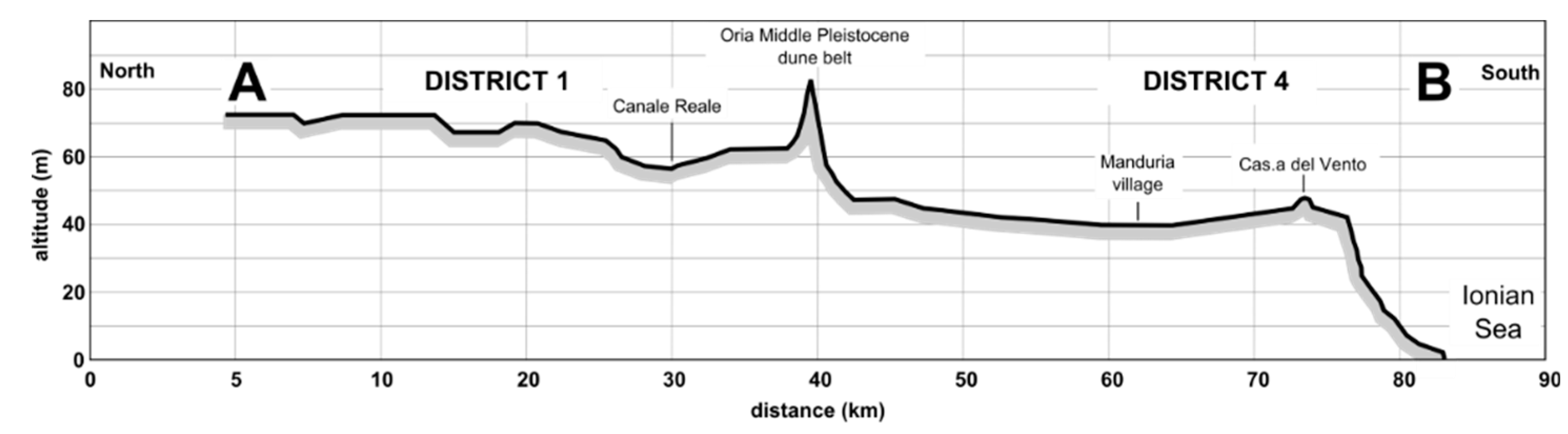
From a geomorphological point of view, the
Murge Tarantine area is a relief elongated in the E–W direction interposed between the
Brindisi-Taranto plain to the north and the coastline to the south. Its western border is the
S. Giorgio Jonico NNW–SSE horst whereas its altitude gradually lowers eastward. Its cross profile is highly asymmetric since the northern slope very gently dips toward the
Limitone dei Greci scarp, marked by the
Oria relict high dune belt, whereas southward it shows a steep slope bordered by three low elevated and narrow marine terraces (
Figure 4).
The local relief is in detail articulated by a sequence of NNW–SSE elongated graben and horst, the first ones filled up by Plio-pleistocene sediments and the latter made of Cretaceous limestones.
4. The Monte del Diavolo Local Geology and Landscape
Different rock units crop out in the
Monte del Diavolo area (
Figure 6). The oldest one is constituted by the
Calcari di Altamura, a Late Cretaceous limestone unit characterized by shallowing upward cycles with rudists facies and developed in inner carbonate-platform environments [
15]. It is covered by three younger formations: the
Calcarenite di Gravina formation, the Marine Terraced Deposits and the Aeolianites. The
Calcarenite di Gravina formation is a very fossiliferous biodetritical calcareous sediment with
Artica islandica Linneo deposited during the Lower Pleistocene. Marine Terraced Deposits formed during the Middle–Upper Pleistocene due to the superimposition of glacioeustatic sea level change and regional uplift [
16,
17]; they are made of bioclastic grainstones with high fossil content. Aeolianites are often associated to Marine Terraced Deposits.
The local landscape of Monte del Diavolo area is dominated by degraded fault scarps; a relict top palaeosurface and a sequence of marine terraces have been also recognized.
The field survey along with aerial photo analysis point out that fault scarps can be clustered into three main systems (
Figure 7). The first one is about E–W oriented and comprises two main scarps which constitute the southern steep border of
Murge Tarantine ridge and strongly influence shoreline position along
Campomarino—
S. Pietro in Bevagna coastal tract.
The other two systems are easily recognizable on the Murge Tarantine ridge, whereas they are less evident on the low elevated coastal area. The second system comprises NW–SE and NE–SW fault scarps which produce horst and graben structures in the area closest to the Monte del Diavolo relief. The last system, showing WNW–ESE- and WSW–ENE-oriented faults, is responsible for the development of horst structures (Monte Bagnolo and Monte della Marina) and indents the main complex tectonic scarp which locally divides the coastal plain from the Murge Tarantine top surface. Fault scarps belonging to the E–W tectonic alignment clearly cuts the other two fault scarp systems producing the main features of the landscape. They are most likely the most evident morphological effects of North Salento Fault Zone occurring in the region.
The landscape of
Monte del Diavolo area is marked at the highest parts of
Murge Tarantine ridge by the remains of an undulating palaeosurface showing a number of low dome-shaped reliefs whose elevation is comprised between 124 m, to the west, and 100 m to the east (
Figure 8):
Monte Bagnolo (124 m),
Casina del Vento (108 m),
Monte dei Castelli (112 m),
Monte dei Serpenti (109 m),
Monte della Marina (100 m) (
Figure 8).
Three narrow eastward sloping marine terraces mark the area stretching between the Murge Tarantine ridge and the shoreline. The first and the highest one is mainly a narrow abrasion platform cut on the limestone basement between 65 and 45 m above m.s.l. The second and the third marine terraces shows a thin sedimentary body covering Mesozoic limestone as well as Lower Quaternary deposits. The higher of two stretches between 32 m above m.s.l. to the west and 15 m above m.s.l. to the east whereas the lower one can be recognized between 12 and 3 m of elevation.
Relict dune belts are associated to marine terraces. They have been found at Specchiarica locality, where the maximum altitude of 27 m is reached, and near Mass. Mirante locality (19 m).
A continuous well-developed mid-Holocene dune belt, up to 14 m high and 150 m wide, borders the present shoreline [
18].
5. The Monte del Diavolo Isolated Relief Morphology and Evolution
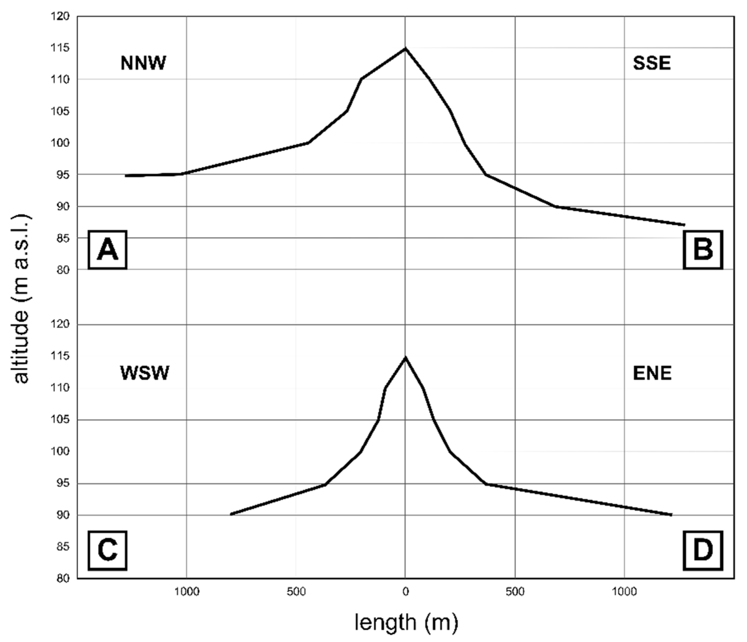
The Monte del Diavolo isolated relief is placed on the top surface of Monti Castelli limestone horst, close to two main fault scarps. It elevates about 20 m from a plain surface, stretching around 95 m altitude, reaching, at its top, 115 m above m.s.l.
The
Monte del Diavolo shows an oblique conical shape; its ellipsoidal basal area has a major axis 1700 m long and a minor one 900 m long. The steeper southern slope has a mean inclination of 5.7%, whereas the northern gentler slope is about 2.8% (
Figure 9 and
Figure 10).
In the area, Mesozoic limestones (
Calcare di Altamura formation) widely crop out. However, at
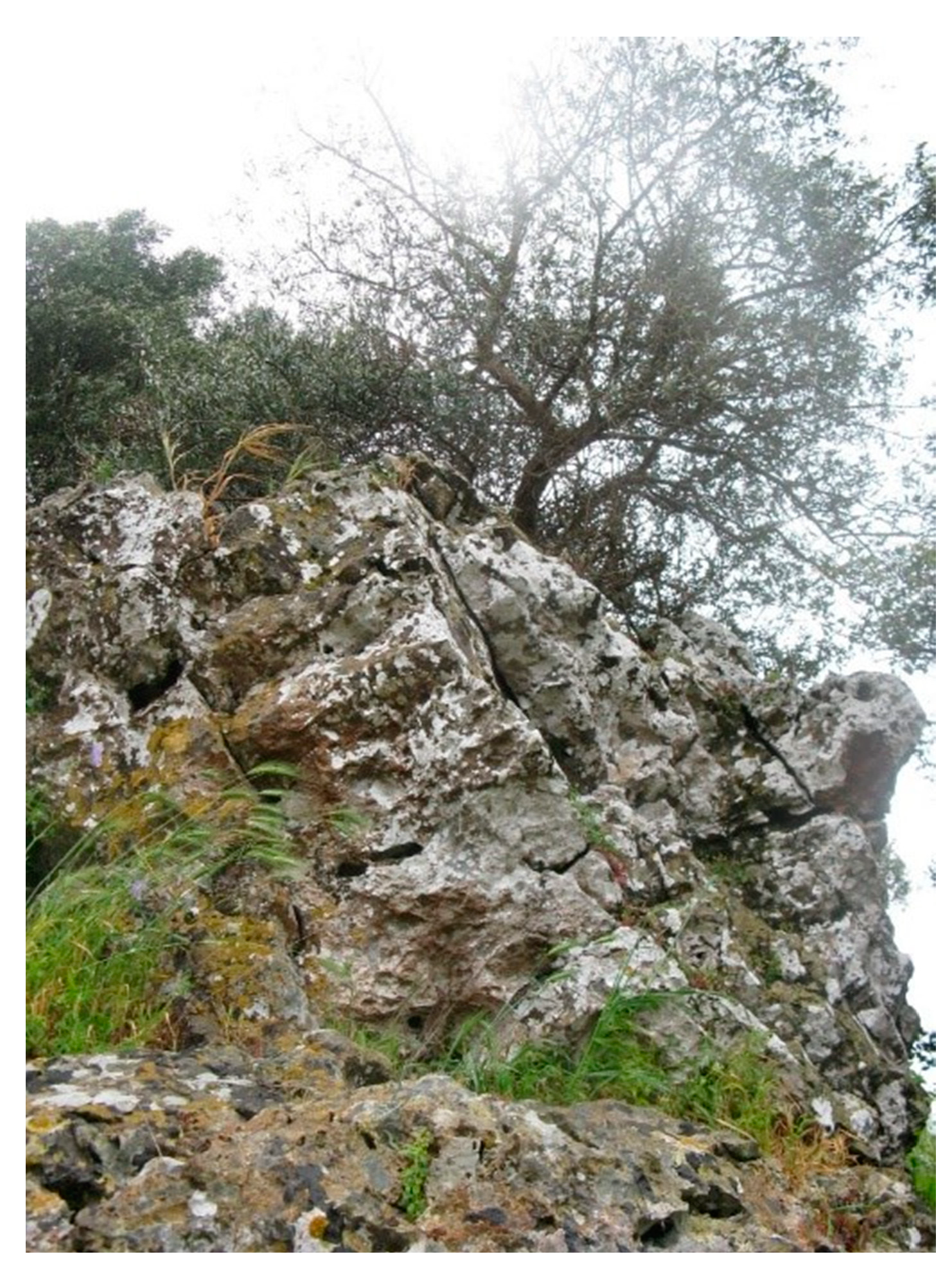
Monte del Diavolo, a massive and well-cemented grain-supported
breccia made of hazel limestone clasts of decametric size was detected; voids are filled with a matrix-supported finer
breccia marked by iron oxides and centimetric limestone clasts (
Figure 11).
According to the classification of palaeo cave deposits proposed by [
19] the detected clastic deposits can be referred to the coarse-clast chaotic
breccia facies produced by cave ceiling and wall collapse. This facies is characterized by a mass of very poorly sorted, granule- to boulder-sized chaotic breccia clasts (i.e., clasts approximately 0.3 to 3 m long), that form a ribbon to tabular shaped body as much as 15 m across and hundreds of meters long.
The deposit is affected by a sub-vertical system of joints dipping northward (
Figure 12); joints widening due to present karst solution is responsible for the detachment of
breccia blocks by gravity (
Figure 13).
Unfortunately, the exposure conditions do not allow the geometry of Monte del Diavolo breccia deposits to be reconstructed. However, a sharp change in the slope angle would suggest that breccia deposits crop out in the upper half of the studied relief.
The lithological difference between the layered limestone bedrock cropping out widely around
Monte del Diavolo area and the
breccia deposits detected at its top could explain the genesis of this isolated relief (
Figure 14).
Breccia deposits are most likely the filling of karst underground voids and are more resistant to denudation processes than the limestone bedrock. The progressive lowering of ground surface, mainly due to surface karst processes, has been faster in the bedrock than areas where
breccia deposits crop out so that an isolated relief gradually has been shaped. The asymmetry of the relief can be attributed to the high-angle joint system that affects
breccia deposits miming stratification, so that a dip and a scarp slope developed.
Small isolated hills due to this particular evolution have been not recorded yet in classical karst areas. However, small hills with a conical or truncated conical shape, or similar to a dome or a tower. have been surveyed in the
Santa Ninfa karst area (
Trapani province, Sicily) [
20]. Their origin is due to the evolution of jointed evaporitic limestone caprock which is deformed along its edge because of chemical erosion of underlying gypsum deposits. Chemical erosion is linked to water infiltrating through the carbonate caprock, which is higher in the area close to its border, whereas it is lower in its centre.
In particular, [
21] defines karst features like
Monte del Diavolo as “
breccia pipe hills”, which are areas of relatively high relief in gypsum karst areas that result from the selective denudation of
breccias composed of different rock types.
Breccias originate due to the collapse of gypsiferous beds and other rocks into cavities formed within deep-seated gypsum beds. Such
breccias commonly have a pipe-like form and locally they can offer more resistance to erosion than do the surrounding rocks. In conclusion, the
Monte del Diavolo isolated relief can be defined as a “
breccia hills” due to differential karstic processes in a limestone area.
6. Developing Geotourism in the Monte del Diavolo Area
The Monte del Diavolo isolated relief could be a valuable source for the development of a local geotourism offer since it shows a number of favourable features. In particular:
- (1)
Its name is particularly attractive;
- (2)
it is part of the history of the local geological knowledge development;
- (3)
it shows peculiar geological and geomorphological features;
- (4)
it displays a unique natural scenery not affected by urbanization;
- (5)
it is inside an archaeological area of great interest;
- (6)
it comprises some natural reserve areas;
- (7)
it is crossed by hiking trails and bike routes;
- (8)
it is close to a coastal area already very popular to tourists.
The promotion of geotourism in the Monte del Diavolo area can be realized following different strategies dedicated to the two main types of involved tourists.
Maps and field guide books illustrating the area stretching from Oria relic belt to the coastline crossing the Monte del Diavolo area could attract “specialized” tourists which visit geosites for the purpose of personal educational or intellectual improvement and enjoyment. The availability of GPS tracks and waypoints as well as remote resources to deepen main topics would facilitate the self-guided visit of the area.
Guided group field trips along bike routes and footpaths should be the main strategy to promote geotourism in the Monte del Diavolo, involving casual tourists which visit geosites and geomorphosites mainly for recreation and pleasure. A geotourism guide can lead a group safely through existing trails, introducing, with a popular language, the main geological, geomorphological, cultural and environmental aspects of the area. In this way the recreation activity is enriched without further effort by a cultural experience. A visitors’ centre at S. Pietro in Bevagna, the most frequented locality occurring along the coast, is needed to promote guided field trips and as a meeting point for interested people. Popular guides can be realized both to advertise field trips and to keep the memory of the lived experience.
7. Conclusions
A small isolated relief, the Monte del Diavolo, marks the morphological district of Murge Tarantine, an area of great geological interest since it shows the morphological effects of the North Salento Fault Zone, a dextral strike-slip fault of regional importance.
The geomorphological survey of Monte del Diavolo revealed that its peculiar morphology can be referred to the presence of well cemented karst breccia deposits produced by cave ceiling and wall collapse. The major resistance to the karst solution of breccia deposits compared to surrounding limestones would be responsible for the shaping of the unusual isolated relief.
Monte del Diavolo is placed in an area marked by a valuable archaeological, cultural and natural heritage that has been unexploited so far notwithstanding the remarkable tourism flow along the nearby coastline. Thanks to its peculiar morphology and name, the Monte del Diavolo isolated relief could represent the focal point of bike routes and footpaths crossing the area between the Oria relic dune belt and the coastline. Maps and field guide books illustrating the main geological and geomorphological features of the area could be produced for “specialized” tourists, whereas “casual” tourist can take advantage of guided field trips, thus joining recreation activity with geotourism.

